Airborne Laser Scanning NEW. Topo-Hydrographic Airborne Laser Scanning System with Online Waveform Processing and Full Waveform Recording
|
|
|
- Matilda Black
- 6 years ago
- Views:
Transcription

 up to two integrated digital cameras NEW form factor with reduced height optimized for")


1 Topo-Hydrographic Airborne Laser Scanning System with Online Waveform Processing and Full Waveform Recording RIEGL VQ-880-GH designed for combined topographic and hydrographic airborne survey high accuracy ranging based on echo digitization and online waveform processing with multiple-target capability multiple-time-around processing for straightforward mission planning and operation concurrent full waveform output for all measurements for subsequent full waveform analysis high spatial resolution due to measurement rate of up to 550 khz and high scanning speed of up to 160 scans/sec integrated inertial navigation system additional, fully integrated infrared laser scanner (optional) up to two integrated digital cameras NEW form factor with reduced height optimized for helicopter integrations The RIEGL VQ-880-GH is a fully integrated airborne laser scanning system for combined hydrographic and topographic surveying. The system is offered with integrated and factory-calibrated high-end GNSS/IMU system and up to two cameras. The design allows flexible application of these components to meet specific requirements. Complemented by a RIEGL data recorder, the RIEGL VQ-880-GH LIDAR system can be installed on various platforms in a straightforward way. The RIEGL VQ-880-GH carries out laser range measurements for high resolution surveying of underwater topography with a narrow, visible green laser beam, emitted from a powerful pulsed laser source. Subject to clarity, at this particular wavelength the laser beam penetrates water enabling measurement of submerged targets. The distance measurement is based on the time-of-flight measurement with very short laser pulses and subsequent echo digitization and online waveform processing. To handle target situations with most complex multiple echo signals, beside the online waveform processing the digitized echo waveforms can be stored on the RIEGL solid state data recorder for subsequent off-line waveform analysis. The laser beam is deflected in a circular scan pattern and hits the water surface at a nominally constant incidence angle. The VQ-880-GH comprises a high precision inertial measurement sensor for subsequent precise estimation of the instrument s exact location and orientation. Two high-resolution digital cameras and an additional infrared laser scanner are integrated to supplement the data gained by the green laser scanner. The rugged internal mechanical structure together with the dust- und splash water proof housing enables long-term operation on airborne platforms. Typical applications include coastline and shallow water mapping acquiring base data for flood prevention measurement for aggradation zones habitat mapping surveying for hydraulic engineering hydro-archeological-surveying visit our website Airborne Laser Scanning


2 RIEGL VQ-880-GH Scan Pattern transmitted laser pulse circular scan of green laser scanner typ. topographic targets line scan of infrared laser scanner received echo signal surface echo bottom echo shore line water surface bottom echo surface echo seabed RIEGL VQ-880-GH Elements of Function and Operation 2


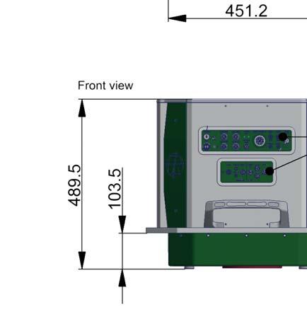
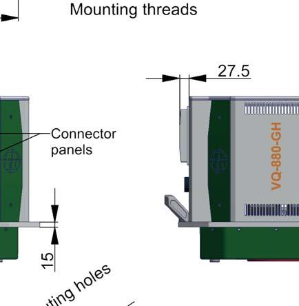
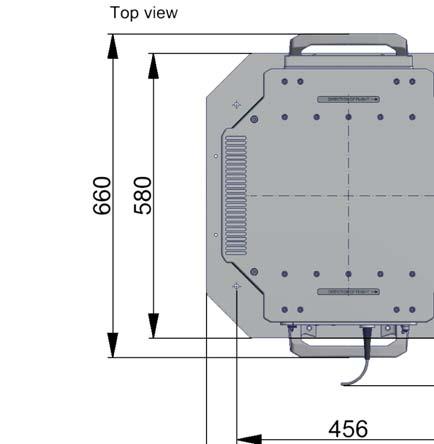
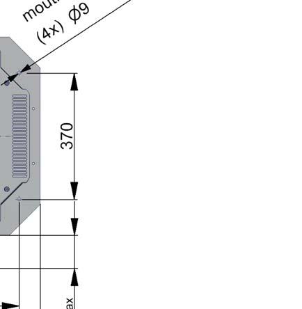
3 RIEGL VQ-880-GH RIEGL VQ-880-G Main Dimensions Housing all dimensions in mm 3

4 RIEGL VQ-880-GH Technical Data of Additional Infrared Laser Scanner Important Note: Laser Product Classification Laser Class The following technical data is relevant for a RIEGL VQ-880-GH Topo-Hydrographic Airborne Laser Scanning System equipped with an additional Infrared Laser Scanner and is to be seen as a supplement to the Technical Data of the Basic System with Green Laser Scanner. for RIEGL VQ-880-GH with additional Infrared Laser Scanner Class 3B Laser Product according to IEC :2014 The following clause applies for instruments delivered into the United States: Complies with 21 CFR and except for deviations pursuant to Laser Notice No. 50, dated June 24, The Instrument must be used only in combination with the appropriate laser safety box. NOHD 1) 175 m 2) 1) NOHD... Nominal Ocular Hazard Distance, based upon MPE according to IEC :2014, for single pulse condition 2) NOHD is determined by green laser scanner. NOHD of the infrared laser scanner: 8 m Range Measurement Performance Measuring Principle time of flight measurement, echo signal digitization, online waveform processing 3) 4) 5) Max. Unambiguous Measurement Laser Pulse Repetition Rate 145 khz 245 khz 550 khz natural targets 20 % 900 m 700 m 500 m natural targets 60 % 1500 m 1200 m 850 m Max. Operating Flight Altitude 6) 800 m (2600 ft.) 650 m (2130 ft.) 450 m (1480 ft.) Above Ground Level (AGL) Minimum Range 7) 8) 10) Accuracy 25 9) 10) Precision 25 11) 12) Laser Pulse Repetition Rate up 6) 12) Max. Effective Measurement Rate m mm mm to 550 khz 000 meas./sec (@ 145 khz PRR & 40 FOV) meas./sec (@245 khz PRR 40 FOV) meas./sec (@ 550 khz PRR & 40 FOV) Echo Signal Intensity for each echo signal, high-resolution 16 bit intensity information is provided Number of Targets per Pulse practically unlimited (details on request) 13) Laser Wavelength nm (near infrared) Laser Beam Divergence 0.2 mrad 14) Laser Beam Footprint (Gaussian Beam Definition) m, m, m Scanner Performance Scanning Mechanism / Scan Pattern rotating polygon mirror / curved parallel lines Field of View (selectable) ± 20 = 40 Scan Speed (selectable) scans/sec Angular Step Width (selectable) between consecutive laser shots Angle Measurement Resolution better (3.6 arcsec) 3) The following conditions are assumed: target larger than the footprint of the laser beam, average ambient brightness, visibility 23 km, perpendicular angle of incidence. 4) In bright sunlight, the operational range may be considerably shorter and the operational flight altitude may be considerably lower than under an overcast sky. 5) Ambiguity to be resolved by post-processing with RiMTA ALS software. 6) Reflectivity 20%, 20 FOV, additional roll angle ±5 7) Limitations for range measurement capability does not consider laser safety. 8) Accuracy is the degree of conformity of a measured quantity to its actual (true) value. 9) Precision, also called reproducibility or repeatability, is the degree to which further measurements show the same result. 10) One 150m range under RIEGL test conditions. 11) Rounded values. 12) User selectable. 13) If the laser beam hits, in part, more than one target, the laser s pulse power is split accordingly. Thus, the achievable range is reduced. 14) Measured at the 1/e² points mrad corresponds to an increase of 20 cm of beam diameter per 1000 m distance. 4
5 RIEGL VQ-880-GH Technical Data of Green Laser Scanner Export Classification The Topo-Hydrographic Airborne Laser Scanner VQ-880-GH has been designed and developed for commercial topographic, hydrographic and bathymetric surveying applications. Laser Product Classification Laser Class NOHD 1) 2) 175 The VQ-880-GH is subject to export restrictions as set up by the Wassenaar Arrangement. It is classified as dual-use good according to position number 6A8j3 of the official Dual-Use-List has to be found on site Within the European Union, Council Regulation (EC) No 428/2009 implements the export restrictions of the Wassenaar Arrangement. The corresponding position number is 6A008j3. for Basic System with Green Laser Scanner Class 3B Laser Product according to IEC :2014 The following clause applies for instruments delivered into the United States: Complies with 21 CFR and except for deviations pursuant to Laser Notice No. 50, dated June 24, The Instrument must be used only in combination with the appropriate laser safety box. m 1) NOHD... Nominal Ocular Hazard Distance 2) If it can be assumed that potential viewers are hit by a single pulse only (e.g., when the instrument is mounted on a platform moving so fast that the pulses do not overlap at the NOHD.) Range Measurement Performance Measuring Principle time of flight measurement, echo signal digitization, online waveform processing, full waveform recording for post processing Hydrography Typ. Measurement Range 3) 1.5 Secchi depth for bright ground ( 80 %) 4) Typ. Operating Flight Altitude 5) 600 m (1970 ft.) Above Ground Level (AGL) Topography (diffusely reflecting targets) 6) 7) 8) Max. Measurement Range natural targets 20 % 2500 m natural targets 60 % 3600 m 8) 5) Typ. Operating Flight Altitude 2200 m (7200 ft.) Above Ground Level (AGL) Minimum Range 10 m 9) 11) Accuracy 25 mm 10) 11) Precision 25 mm Laser Pulse Repetition Rate up to 550 khz 5) Max. Effective Measurement Rate 5) up to meas./sec (@ 550 khz PRR) Echo Signal Intensity for each echo signal, high-resolution 16 bit intensity information is provided Number of Targets per Pulse online waveform processing: up to 9, depending on measurement program 12) Laser Wavelength 532 nm, green Laser Beam Divergence selectable, 0.7 up to 2.0 mrad 13) Laser Beam Footprint (Gaussian Beam Definition) m, m, m 14) Scanner Performance Scanning Mechanism / Scan Pattern rotating prism / circular Field of View (selectable) ± 20 = 40 Scan Speed (selectable) revolutions/sec, equivalent to scans/sec Angular Step Width (selectable) (for PRR 550 khz) between consecutive laser shots Angle Measurement Resolution better (3.6 arcsec) 15) 16) IMU/GNSS Performance IMU Accuracy 17) Roll, Pitch Heading IMU Sampling Rate 200 Hz Position Accuracy (typ.) horizontal / vertical <0.05 m / <0.1 m 3) The Secchi depth is defined as the depth at which a standard black and white disc deployed into the water is no longer visible to the human eye. 4) at typ. operating flight altitude 5) rounded values 6) The following conditions are assumed: target larger than the footprint of the laser beam, average ambient brightness, visibility 23 km, perpendicular angle of incidence, ambiguity to be resolved multiple-time-around processing. 7) In bright sunlight, the operational range may be considerably shorter than under an overcast sky. 8) Reflectivity 20%, 40 FOV, additional roll angle ±5 9) Accuracy is the degree of conformity of a measured quantity to its actual (true) value. 10) Precision, also called reproducibility or repeatability, is the degree to which further measurements show the same result. 11) Topography, one 150m range under RIEGL test conditions. 12) If the laser beam hits, in part, more than one target, the laser s pulse power is split accordingly. Thus, the achievable range is reduced. 13) Measured at the 1/e² points. 1.0 mrad corresponds to an increase of 100 mm of beam diameter per 100 m distance. 14) The laser beam footprint values correspond to a beam divergence of 1mrad. 15) The INS configuration of the RIEGL VQ-880-GH Laser Scanning System can be modified to the customer s requirements. 16) The installed IMU is listed neither in the European Export Control List (i.e. Annex 1 of Council Regulation 428/2009) nor in the Canadian Export Control List. Detailed information on certain cases will be provided on request. 17) one sigma values, no GNSS outages, post-processed during base station data 5
6 RIEGL VQ-880-GH Technical Data Integrated Digital Cameras 1) RGB Camera Sensor Resolution up to 100 MPixel CMOS without FMC 2) or up to 80 MPixel CCD with FMC 2) Sensor Dimensions (diagonal) 67.2 mm (medium format) Focal Length of Camera Lens 50 mm Field of View (FOV) approx x 43.7 Interface USB 3.0 Data Storage separate dedicated data recorder Data Interfaces Configuration Scan Data Output GNSS Interface 3) LAN 10/100/1000 Mbit/sec LAN 10/100/1000 Mbit/sec, High Speed Serial Dual Glass Fiber Link to RIEGL Data Recorder DR1560 Serial RS232 interface for data string with GNSS-time information, TTL input for 1 PPS synchronization pulse General Technical Data Power Supply Input Voltage Power Consumption Main Dimensions (LxWxH) Weight Humidity Protection Class Scan Head Max. Flight Altitude 5) operating not operating) Temperature Range operation / storage 1) The camera configuration of the RIEGL VQ-880-GH Laser Scanning System can be modified to the customer s requirements. 2) Forward Motion Compensation V DC typ. 330 W (without IMU/GNSS/cameras) typ. 370 W (with IMU/GNSS/cameras) 4) max. 400 W mm x 660 mm x 580 mm, mounting flange 580 mm x 580 mm approx. 70 kg (with IMU/GNSS/cameras and optional infrared laser scanner) non condensing IP54, dust and splash-proof ft (5 000 m) above Mean Sea Level (MSL) ft (5 500 m) above MSL 0 C up to +40 C / -10 C up to +50 C 3) to be used for external GNSS receiver 20 C ambient temperature, 100 khz PRR, 100 scans/sec 5) For standard atmospheric conditions: 1013 mbar, +15 C at sea level RIEGL Laser Measurement Systems GmbH Riedenburgstraße Horn, Austria Phone: Fax: office@riegl.co.at Use of this data sheet other than for personal purposes requires RIEGL s written consent. This data sheet is compiled with care. However, errors cannot be fully excluded and alternations might be necessary. RIEGL USA Inc. Orlando, Florida info@rieglusa.com RIEGL Japan Ltd. Tokyo, Japan info@riegl-japan.co.jp RIEGL China Ltd. Beijing, China info@riegl.cn RIEGL VQ-880-GH,
Airborne Laser Scanning. Topo-Hydrographic Airborne Laser Scanning System with Online Waveform Processing and Full Waveform Recording
 Topo-Hydrographic Airborne Laser Scanning System with Online Waveform Processing and Full Waveform Recording RIEGL VQ-880-GH designed for combined topographic and hydrographic airborne survey high accuracy
RIEGL VQ-880-G NEW. Airborne Laser Scanning
 Topo-Hydrographic Airborne Laser Scanning System with Online Waveform Processing and Full Waveform Recording NEW RIEGL VQ-880-G II designed for combined topographic and hydrographic airborne survey green
RIEGL VUX-240 PRELIMINARY NEW. Airborne Laser Scanning. Lightweight UAV Laser Scanner with Online Waveform Processing. visit our website
 Lightweight UAV Laser Scanner with Online Waveform Processing NEW RIEGL VUX-240 laser pulse repetition rate up to 1.8 MHz measurement rate up to 1,500,000 meas./sec scan speed up to 400 lines/second operating
Full Waveform Digitizing, Dual Channel Airborne LiDAR Scanning System for Ultra Wide Area Mapping
 Full Waveform Digitizing, Dual Channel Airborne LiDAR Scanning System for Ultra Wide Area Mapping RIEGL LMS-Q56 high laser pulse repetition rate up to 8 khz digitization electronics for full waveform data
Mobile Laser Scanning. High-Performance LiDAR Sensor for KINEMATIC Laser Scanning. visit our website
 High-Performance LiDAR Sensor for KINEMATIC Laser Scanning RIEGL VUX-1HA very high measurement rate up to 1,, meas./sec very high scan speed up to 25 scans / second 5 mm survey-grade accuracy field of
The V-Line Airborne Laser Scanner RIEGL
 Airborne Laser Scanner with Online Waveform Processing RIEGL VQ-48i high-accuracy ranging based on echo digitization and online waveform processing high laser repetition rate - fast data acquisition multiple
Dual Channel Waveform Processing Airborne LiDAR Scanning System for High Point Density and Ultra Wide Area Mapping
 Dual Channel Waveform Processing Airborne LiDAR Scanning System for High Point Density and Ultra Wide Area Mapping RIEGL VQ-156i high laser pulse repetition rate: up to 2 MHz up to 1.33 million measurements
RIEGL VQ-480-U. Airborne Laser Scanning. Lightweight Airborne Laser Scanner with Online Waveform Processing. visit our website
 Lightweight Airborne Laser Scanner with Online Waveform Processing RIEGL VQ-48-U high-accuracy ranging based on echo digitization and online waveform processing high laser repetition rate - fast data acquisition
RIEGL VQ -780i NEW. Airborne Laser Scanning. Waveform Processing Airborne Laser Scanner for Ultra Wide Area Mapping and High Productivity.
 Waveform Processing Airborne Laser Scanner for Ultra Wide Area Mapping and High Productivity. NEW RIEGL VQ -78i online waveform processing as well as smart and full waveform recording excellent multiple
NEW. Airborne Laser Scanning. Waveform Processing Airborne Laser Scanner for Wide Area Mapping and High Productivity. visit our website
 Waveform Processing Airborne Laser Scanner for Wide Area Mapping and High Productivity. NEW RIEGL VQ -780i online waveform processing as well as smart and full waveform recording excellent multiple target
RIEGL VQ-580. Airborne Laser Scanning. Airborne Laser Scanner with Online Waveform Processing. visit our website
 Airborne Laser Scanner with Online Waveform Processing RIEGL VQ-580 especially designed to measure on snow & ice high-accuracy ranging based on echo digitization and online waveform processing high laser
NEW. Airborne Laser Scanning. Dual Wavelength Waveform Processing Airborne LiDAR Scanning System for High-Point Density Mapping Applications
 Dual Wavelength Waveform Processing Airborne LiDAR Scanning System for High-Point Density Mapping Applications NEW RIEGL VQ-156i-DW enhanced target characterization based upon simultaneous measurements
RIEGL VQ-580. Airborne Laser Scanning. Airborne Laser Scanner with Online Waveform Processing. visit our website Preliminary Datasheet
 Airborne Laser Scanner with Online Waveform Processing RIEGL VQ-580 especially designed to measure on snow & ice high-accuracy ranging based on echo digitization and online waveform processing high laser
Dual Channel Waveform Processing Airborne LiDAR Scanning System for High-Point Density and Ultra-Wide Area Mapping
 Dual Channel Waveform Processing Airborne LiDAR Scanning System for High-Point Density and Ultra-Wide Area Mapping RIEGL VQ-156i high laser pulse repetition rate up to 2 MHz up to 1.33 million measurements
Airborne Laser Scanning. Lightweight Airborne Laser Scanner with Online Waveform Processing. visit our website
 Lightweight Airborne Laser Scanner with Online Waveform Processing RIEGL VUX-1LR 15 mm survey-grade accuracy scan speed up to 2 scans / second measurement rate up to 75, meas./sec operating flight altitude
RIEGL s VUX-1HA High Accuracy kinematic LiDAR sensor is a very high
 High-Performance LiDAR Sensor for KINEMATIC Laser Scanning RIEGL VUX-1HA very high measurement rate up to 1,, meas./sec very high scan speed up to 25 scans / second 5 mm survey-grade accuracy field of
RIEGL VUX-1UAV. Unmanned Laser Scanning. Lightweight UAV Laser Scanner with Online Waveform Processing. visit our website
 Lightweight UAV Laser Scanner with Online Waveform Processing RIEGL VUX-1UAV 1 mm survey-grade accuracy scan speed up to 2 scans / second measurement rate up to 5, meas./sec (@ 55 khz PRR & 33 FOV) operating
Airborne Laser Scanning. Lightweight Airborne Laser Scanner with Online Waveform Processing. visit our website
 Lightweight Airborne Laser Scanner with Online Waveform Processing RIEGL VUX-1LR 15 mm survey-grade accuracy scan speed up to 2 scans / second measurement rate up to 75, meas./sec operating flight altitude
Mobile Laser Scanning. High-Performance LiDAR Sensor for KINEMATIC Laser Scanning. visit our website
 High-Performance LiDAR Sensor for KINEMATIC Laser Scanning RIEGL VUX-1HA very high measurement rate up to 1,, meas./sec very high scan speed up to 25 scans / second 5 mm survey-grade accuracy field of
LMS-Q780. Airborne Laser Scanning. Full Waveform Digitizing Airborne Laser Scanner for Wide Area Mapping. visit our website
 Full Waveform Digitizing Airborne Laser Scanner for Wide Area Mapping LMS-Q78 up to 266 measurements/sec on the ground even from a typical operating altitude of 67 ft multiple time around processing: up
Dual Wavelength Waveform Processing Airborne LiDAR Scanning System for High-Point Density Mapping Applications
 Dual Wavelength Waveform Processing Airborne LiDAR Scanning System for High-Point Density Mapping Applications NEW RIEGL VQ-156i-DW enhanced target characterization based upon simultaneous measurements
RIEGL VZ Terrestrial Laser Scanning. 3D Very Long Range Terrestrial Laser Scanner with Online Waveform Processing
 3D Very Long Range Terrestrial Laser Scanner with Online Waveform Processing RIEGL VZ- very long range up to 4 m eye safe operation at Laser Class 1 wide field of view, 6 x 36 high speed data acquisition
Terrestrial Laser Scanning. 3D Very Long Range Terrestrial Laser Scanner with Online Waveform Processing. visit our website e
 3D Very Long Range Terrestrial Laser Scanner with Online Waveform Processing RIEGL VZ- very long range up to 4 m eye safe operation at Laser Class 1 wide field of view, 6 x 36 high speed data acquisition
AIRBORNE LASER SCANNER FOR FULL WAVEFORM ANALYSIS. visit our webpage
 AIRBORNE LASER SCANNER LMS-Q560 FOR FULL WAVEFORM ANALYSIS The RIEGL LMS-Q560 is a revolutionary D laser scanner using the latest state-of-the-art digital signal processing, which meets the most challenging
AIRBORNE LASER SCANNER FOR FULL WAVEFORM ANALYSIS. visit our webpage
 AIRBORNE LASER SCANNER LMS-Q560 FOR FULL WAVEFORM ANALYSIS The RIEGL LMS-Q560 is a revolutionary new D laser scanner using the latest state-of-the-art digital signal processing, which meets the most challenging
Preliminary Datasheet
 LONG-RANGE AIRBORNE LASER SCANNER LMS-Q680 FOR FULL WAVEFORM ANALYSIS The new long-range RIEGL LMS-Q680 airborne laser scanner makes use of a powerful laser source and of RIEGL s proprietary digital full
Airborne Laser Scanning. Long-Range Airborne Laser Scanner for Full Waveform Analysis. visit our webpage LASER MEASUREMENT SYSTEMS
 Long-Range Airborne Laser Scanner for Full Waveform Analysis LMS-Q680 The long-range RIEGL LMS-Q680 airborne laser scanner makes use of a powerful laser source and of RIEGL s proprietary digital full waveform
DIGITAL LASER DISTANCE METER
 DIGITAL LASER DISTANCE METER LD05-A80 The RIEGL LD05-A80 is a multi-purpose laser distance meter based on precise time-of-flight laser range measurement. It uses state-of-the-art digital signal processing
LMS-Q780. Airborne Laser Scanning. Full Waveform Digitizing Airborne Laser Scanner for Wide Area Mapping. Preliminary Datasheet
 Full Waveform Digitizing Airborne Laser Scanner for Wide Area Mapping LMS-Q78 l up to 66 measurements/sec on the ground even from a typical operating altitude of 67 ft l multiple time around processing:
DIGITAL LASER DISTANCE METER
 DIGITAL LASER DISTANCE METER LD05-A10GF with glass-fiber coupled remote optical head The RIEGL LD05-A10GF is a multi-purpose laser distance meter based on precise timeof-flight laser range measurement
Terrestrial Laser Scanning. 3D Laser Scanner with Real-Time Registration & Processing. Preliminary Data Sheet
 VZ 4 3D Laser Scanner with Real-Time Registration & Processing RIEGL VZ-4i new, innovative processing architecture for data acquisition and simultaneous geo-referencing, filtering and analysis in real-time
Long Range, High Speed 3D Terrestrial Laser Scanner with Online Waveform Processing. RIEGL s unique V-Line technology, based on echo digitization,
 Long Range, High Speed 3D Terrestrial Laser Scanner with Online Waveform Processing RIEGL VZ-2 very long range up to more than 2, m very high effective measurement rate up to 4, meas./sec eye safe operation
Airborne Laser Scanning. Lightweight Airborne Laser Scanner with Online Waveform Processing. visit our website Preliminary Data Sheet
 Lightweight Airborne Laser Scanner with Online Waveform Processing RIEGL VUX-1 The RIEGL VUX-1 is a very lightweight and compact laser scanner, 1 mm survey-grade accuracy scan speed up to 2 scans / second
Sampling the World in 3D by Airborne LIDAR Assessing the Information Content of LIDAR Point Clouds
 Sampling the World in 3D by Airborne LIDAR Assessing the Information Content of LIDAR Point Clouds PhoWo 2013 September 11 th, 2013 Stuttgart, Germany Andreas Ullrich RIEGL LMS GmbH sequential data acquisition
NEW. Terrestrial Laser Scanning. Long Range, Very High Speed 3D Laser Scanner. visit our website Preliminary Data Sheet
 Long Range, Very High Speed 3D Laser Scanner NEW RIEGL RIEGL VZ-2000i high laser pulse repetition rate of up to 1.2 MHz high speed data acquisition with up to 500,000 measurements/sec eye safe operation
Terrestrial Laser Scanning. Ultra High Performance 3D Laser Scanner. visit our website Preliminary Data Sheet
 Ultra High Performance 3D Laser Scanner RIEGL VZ-400i high laser pulse repetition rate of up to 1.2 MHz high speed data acquisition with up to 500,000 measurements/sec eye safe operation at Laser Class
Terrestrial Laser Scanning. Ultra High Performance 3D Laser Scanner. visit our website
 Ultra High Performance 3D Laser Scanner RIEGL VZ-400i high laser pulse repetition rate of up to 1.2 MHz high speed data acquisition with up to 500,000 measurements/sec eye safe operation at Laser Class
Think of LASER as a tool
 Mini DPSS Lasers Mini DPSS Lasers Think of LASER as a tool Mini DPSS Mini DPSS Lasers Lasers Versatility. Flexibility. Reliability. The mosquitoo and mosquitoo X series of mini DPSS lasers are designed
zforce AIR Touch Sensor Specifications
 zforce AIR Touch Sensor 2017-12-21 Legal Notice Neonode may make changes to specifications and product descriptions at any time, without notice. Do not finalize a design with this information. Neonode
14 Technical Data Angle Measurement. Accuracy. Available angular accuracies. Display resolution. Standard deviation Hz, V, ISO
 14 Technical Data 14.1 Angle Measurement Accuracy Available angular accuracies Standard deviation Hz, V, ISO 17123-3 Display resolution ["] [mgon] ["] [ ] [mgon] [mil] 1 0.3 1 0.0001 0.1 0.01 2 0.6 1 0.0001
Q-SWITCHED LASERS. Engineered Reliability. Rugged Design. No Water. Applications. Features
 Q-SWITCHED LASERS nanio nanio air* air* Industrial DPSS Industrial DPSS Lasers Lasers Engineered Reliability. Rugged Design. No Water. The NANIO AIR lasers are a family of Q-switched DPSS lasers engineered
IR Laser Illuminators
 Eagle Vision PAN/TILT THERMAL & COLOR CAMERAS - All Weather Rugged Housing resist high humidity and salt water. - Image overlay combines thermal and video image - The EV3000 CCD colour night vision camera
Atlantic. Industrial High Power Picosecond Lasers. features
 Atlantic Industrial High Power Picosecond Lasers lasers have been designed as a versatile tool for a variety of industrial material processing applications. They are compact, OEM rugged, with up to 8 W
Microwave Remote Sensing (1)
") Microwave Remote Sensing (1) Microwave sensing encompasses both active and passive forms of remote sensing. The microwave portion of the spectrum covers the range from approximately 1cm to 1m in wavelength.
Microwave Remote Sensing (1) Microwave sensing encompasses both active and passive forms of remote sensing. The microwave portion of the spectrum covers the range from approximately 1cm to 1m in wavelength.
Helicopter Aerial Laser Ranging
 Helicopter Aerial Laser Ranging Håkan Sterner TopEye AB P.O.Box 1017, SE-551 11 Jönköping, Sweden 1 Introduction Measuring distances with light has been used for terrestrial surveys since the fifties.
Features. Applications. Optional Features
 Features Compact, Rugged Design TEM Beam with M 2 < 1.2 Pulse Rates from Single Shot to 15 khz IR, Green, UV, and Deep UV Wavelengths Available RS232 Computer Control Patented Harmonic Generation Technology
DOC_ID:SS Introduction sheet. CCD linear scan engine. Product name MDC-100. Issue NO DM DOC_ID SS13070
 DOC_ID:SS13070 Introduction sheet CCD linear scan engine Product name MDC-100 Issue NO DM-140312 DOC_ID SS13070 Issue Date 2014/03/26 Version Preliminary DOC_ID:SS13070 INDEX 1. ABSTRACT...1 2. OVERVIEW...1
Fugro commence new Airborne Lidar Bathymetry trials
 Fugro commence new Airborne Lidar Bathymetry trials Laurent Pronier 20 May 2011 Marrakech, Morocco, 18-22 May 2011 Contents Menu LADS Technology - History LADS Mk I (RAN LADS I) LADS Mk II RAN LADS II
Scanner Basic Configuration Part-No. 21R
 Scanner Basic Configuration Part-No. 21R09-00-101-00 3D Laser Scanner Part-No. 21R09-00-001-00 laser transmitter & receiver front end motorized mirror scanning mechanism signal processing electronics with
LTE. Tester of laser range finders. Integrator Target slider. Transmitter channel. Receiver channel. Target slider Attenuator 2
 a) b) External Attenuators Transmitter LRF Receiver Transmitter channel Receiver channel Integrator Target slider Target slider Attenuator 2 Attenuator 1 Detector Light source Pulse gene rator Fiber attenuator
Spatially Resolved Backscatter Ceilometer
 Spatially Resolved Backscatter Ceilometer Design Team Hiba Fareed, Nicholas Paradiso, Evan Perillo, Michael Tahan Design Advisor Prof. Gregory Kowalski Sponsor, Spectral Sciences Inc. Steve Richstmeier,
PRODUCT OVERVIEW FOR THE. Corona 350 II FLIR SYSTEMS POLYTECH AB
 PRODUCT OVERVIEW FOR THE Corona 350 II FLIR SYSTEMS POLYTECH AB Table of Contents Table of Contents... 1 Introduction... 2 Overview... 2 Purpose... 2 Airborne Data Acquisition and Management Software (ADAMS)...
The Normal Baseline. Dick Gent Law of the Sea Division UK Hydrographic Office
 The Normal Baseline Dick Gent Law of the Sea Division UK Hydrographic Office 2 The normal baseline for measuring the breadth of the territorial sea is the low water line along the coast as marked on large
SYSTEM 5900 SIDE SCAN SONAR
 SYSTEM 5900 SIDE SCAN SONAR HIGH-RESOLUTION, DYNAMICALLY FOCUSED, MULTI-BEAM SIDE SCAN SONAR Klein Marine System s 5900 sonar is the flagship in our exclusive family of multi-beam technology-based side
DM Dual Head Green Series
 DM Dual Head Green Series DM20/30/40-527-DH DM50/60-527-DH DM100-527-DH DM60-532-DH DM100-532-DH DM150-532-DH DM200-532-DH PI offers any of its DM Series lasers in a Dual Head (DH) option. This option,
Z+F IMAGER 5006i. IMAGER 5006EX the world s only explosion proof 3D laser scanner.
 Z+F IMAGER 5006i IMAGER 5006EX the world s only explosion proof 3D laser scanner www.zf-laser.com IMAGER 5 0 0 6 EX Kabellose Bedienung mit einem PDA über WLAN Based on the high quality laser scanner Z+F
Sub-system and System Level Testing and Calibration of Space Altimeters and LIDARS.
 Sub-system and System Level Testing and Calibration of Space Altimeters and LIDARS. Haris Riris, Pete Liiva, Xiaoli Sun, James Abshire Laser Remote Sensing Branch Goddard Space Flight Center, Greenbelt,
Continuous-Wave (CW) Single-Frequency IR Laser. NPRO 125/126 Series
 Single-Frequency IR Laser. NPRO 125/126 Series") Continuous-Wave (CW) Single-Frequency IR Laser NPRO 125/126 Series www.lumentum.com Data Sheet The Lumentum NPRO 125/126 diode-pumped lasers produce continuous-wave (CW), singlefrequency output at either
Continuous-Wave (CW) Single-Frequency IR Laser NPRO 125/126 Series www.lumentum.com Data Sheet The Lumentum NPRO 125/126 diode-pumped lasers produce continuous-wave (CW), singlefrequency output at either
Three-dimensional investigation of buried structures with multi-transducer parametric sub-bottom profiler as part of hydrographical applications
 Three-dimensional investigation of buried structures with multi-transducer parametric sub-bottom profiler as part Jens LOWAG, Germany, Dr. Jens WUNDERLICH, Germany, Peter HUEMBS, Germany Key words: parametric,
A LATERAL SENSOR FOR THE ALIGNMENT OF TWO FORMATION-FLYING SATELLITES
 A LATERAL SENSOR FOR THE ALIGNMENT OF TWO FORMATION-FLYING SATELLITES S. Roose (1), Y. Stockman (1), Z. Sodnik (2) (1) Centre Spatial de Liège, Belgium (2) European Space Agency - ESA/ESTEC slide 1 Outline
Phase One 190MP Aerial System
 White Paper Phase One 190MP Aerial System Introduction Phase One Industrial s 100MP medium format aerial camera systems have earned a worldwide reputation for its high performance. They are commonly used
Triple-IN. Selection table: 3D Scanner PSCXXX-90 Summary: Technical Data. PSCXXX-90 preliminary Technical Data. Triple-IN GmbH PSCXXX-90/14.
 Selection table: 3D Scanner PSC-90 Summary: Technical Data Triple-IN GmbH PSC-90 preliminary Technical Data Sensor PSC300-90 PSC250-90 PSC150-90 PSC100-90 Order No. 5300 5200 5100 5000 2D Scanner is based
9/12/2011. Training Course Remote Sensing Basic Theory & Image Processing Methods September 2011
 Training Course Remote Sensing Basic Theory & Image Processing Methods 19 23 September 2011 Remote Sensing Platforms Michiel Damen (September 2011) damen@itc.nl 1 Overview Platforms & missions aerial surveys
CODEVINTEC. Miniature and accurate IMU, AHRS, INS/GNSS Attitude and Heading Reference Systems
 45 27 39.384 N 9 07 30.145 E Miniature and accurate IMU, AHRS, INS/GNSS Attitude and Heading Reference Systems Aerospace Land/Automotive Marine Subsea Miniature inertial sensors 0.1 Ellipse Series New
Super High Vertical Resolution Non-Contact 3D Surface Profiler BW-S500/BW-D500 Series
 Super High Vertical Resolution Non-Contact 3D Surface Profiler BW-S500/BW-D500 Series Nikon's proprietary scanning-type optical interference measurement technology achieves 1pm* height resolution. * Height
Cost efficient design Operates in full sunlight Low power consumption Wide field of view Small footprint Simple serial connectivity Long Range
 Cost efficient design Operates in full sunlight Low power consumption Wide field of view Small footprint Simple serial connectivity Long Range sweep v1.0 CAUTION This device contains a component which
How-to guide. Working with a pre-assembled THz system
 How-to guide 15/06/2016 1 Table of contents 0. Preparation / Basics...3 1. Input beam adjustment...4 2. Working with free space antennas...5 3. Working with fiber-coupled antennas...6 4. Contact details...8
Laser Telemetric System (Metrology)
") Laser Telemetric System (Metrology) Laser telemetric system is a non-contact gauge that measures with a collimated laser beam (Refer Fig. 10.26). It measure at the rate of 150 scans per second. It basically
Laser Telemetric System (Metrology) Laser telemetric system is a non-contact gauge that measures with a collimated laser beam (Refer Fig. 10.26). It measure at the rate of 150 scans per second. It basically
DECISION NUMBER FOURTEEN TO THE TREATY ON OPEN SKIES
 DECISION NUMBER FOURTEEN TO THE TREATY ON OPEN SKIES OSCC.DEC 14 12 October 1994 METHODOLOGY FOR CALCULATING THE MINIMUM HEIGHT ABOVE GROUND LEVEL AT WHICH EACH VIDEO CAMERA WITH REAL TIME DISPLAY INSTALLED
By Pierre Olivier, Vice President, Engineering and Manufacturing, LeddarTech Inc.
 Leddar optical time-of-flight sensing technology, originally discovered by the National Optics Institute (INO) in Quebec City and developed and commercialized by LeddarTech, is a unique LiDAR technology
Preliminary Specification
 Preliminary Specification CONTENTS 1.1 SCOPE 2 1.2 OPTICAL SPECIFICATION 2 1.3 BEAM DELIVERY FIBER SPECIFICATION 3 1.4 ALIGNMENT LASER 3 1.5 POWER DISTRIBUTION 3 1.6 WATER COOLING REQUIREMENTS 4 1.7 CONTROL
Technical Explanation for Displacement Sensors and Measurement Sensors
 Technical Explanation for Sensors and Measurement Sensors CSM_e_LineWidth_TG_E_2_1 Introduction What Is a Sensor? A Sensor is a device that measures the distance between the sensor and an object by detecting
1 Introduction integrated 3D sonar system for underwater inspection applications
 1 Introduction The Underwater Inspection System (UIS TM ) is an integrated 3D sonar system for underwater inspection applications, specifically port and harbor construction, maintenance, port expansion,
INPROX sensors. displacement MLS compact ccd-laser distance sensor
 compact ccd- distance sensor MLS7-250 high vibration and shock resistant -CCD specifications measuring range 250mm resolution >50µm measuring frequency 1000Hz small dimensions (mm) (65x50x20) high shock
Vision Lighting Seminar
 Creators of Evenlite Vision Lighting Seminar Daryl Martin Midwest Sales & Support Manager Advanced illumination 734-213 213-13121312 dmartin@advill.com www.advill.com 2005 1 Objectives Lighting Source
Govt. Engineering College Jhalawar Model Question Paper Subject- Remote Sensing & GIS
 Govt. Engineering College Jhalawar Model Question Paper Subject- Remote Sensing & GIS Time: Max. Marks: Q1. What is remote Sensing? Explain the basic components of a Remote Sensing system. Q2. What is
200W 500W, Air Cooled QUBE Fiber Lasers
 Technical Specification 200W 500W, Air Cooled QUBE Fiber Lasers CONTENTS 1.1 SCOPE 2 1.2 OPTICAL SPECIFICATION 2 1.3 BEAM DELIVERY FIBER SPECIFICATION 3 1.4 ALIGNMENT LASER 4 1.5 POWER DISTRIBUTION 4 1.6
NA DigiParts GmbH. Small / Slim Object Detection Area Sensor
 953 PHOTO PHOTO MEASURE ITY Object Area Sensor General terms and conditions... F-7 Related Information Glossary of terms... P.1455~ Cross-beam scanning system to detect slim objects Letters or business
NA1-11. Small / Slim Object Detection Area Sensor. Cross-beam scanning system to detect slim objects. Letters or business cards detectable!
 891 Object Area Sensor General terms and conditions... F-17 Related Information Glossary of terms... P.1359~ Sensor selection guide...p.831~ General precautions... P.1405 PHOTO PHOTO Conforming to EMC
Passive Microwave Sensors LIDAR Remote Sensing Laser Altimetry. 28 April 2003
 Passive Microwave Sensors LIDAR Remote Sensing Laser Altimetry 28 April 2003 Outline Passive Microwave Radiometry Rayleigh-Jeans approximation Brightness temperature Emissivity and dielectric constant
Laser Contour Log Profiling System
 Sitronic Laser Contour Log Profiling System LKM-400 LKM-700 LKM-900 LKM-1100 LKM-1400 2 Laser Log Profiling System (Log Measuring System) The Laser Profiling System LKM is a complete measuring system that
RPLIDAR A1. Introduction and Datasheet. Low Cost 360 Degree Laser Range Scanner rev.2.1. Model: A1M8. Shanghai Slamtec.Co.
 www.slamtec.com 2018-02-05 rev.2.1 RPLIDAR A1 Low Cost 360 Degree Laser Range Scanner Introduction and Datasheet Model: A1M8 Shanghai Slamtec.Co.,Ltd Contents CONTENTS... 1 INTRODUCTION... 3 SYSTEM CONNECTION...
Autotracker III. Applications...
 Autotracker III Harmonic Generation System Model AT-III Applications... Automatic Second Harmonic and Third Harmonic Generation of UV Wavelengths Automatic Production of IR Wavelengths by Difference Frequency
APPLICATIONS FOR TELECENTRIC LIGHTING
 APPLICATIONS FOR TELECENTRIC LIGHTING Telecentric lenses used in combination with telecentric lighting provide the most accurate results for measurement of object shapes and geometries. They make attributes
Intermediate 2 Waves & Optics Past Paper questions
 Intermediate 2 Waves & Optics Past Paper questions 2000-2010 2000 Q29. A converging lens has a focal length of 30 mm. (a) Calculate the power of this lens. (i) In the diagram below, which is drawn to scale,
Emitting and receiving element pitch: 10 mm in
 Small / Slim Object Detection Area Sensor Cross-beam scanning system to detect slim objects Letter or visiting card detectable! Slim objects can be detected by using the cross-beam scanning system. Emitting
Safety Issues of the Baseband IR PHY
 Aueust 1994 doc: IEEE P802.11-94/174 IEEE 802.11 Wireless Access Method and Physical Layer Specification Title: Safety Issues of the Baseband IR PHY Authors: Cipriano R. A. T. Lomba, Rui T. Valadas, A.M.
Survey Sensors. 18/04/2018 Danny Wake Group Surveyor i-tech Services
 Survey Sensors 18/04/2018 Danny Wake Group Surveyor i-tech Services What do we need sensors for? For pure hydrographic surveying: Depth measurements Hazard identification Seabed composition Tides & currents
Genesis CX STM-Series
 Coherent s unique Optically Pumped Semiconductor Laser (OPSL) technology powers the Genesis CX-STM Series, providing up to 250 mw of UV laser light or up to 10W of visible laser light from either OEM or
From the First Flight of SEAHAWK
 From the First Flight of SEAHAWK Joong Yong Park (ELiT Geomatics), Hyunsuk Kim, Eunyoung Kim, Gwangjae We (Geostory), Thomas Craney, Eric Brown, Domenic Carr, Christopher R. Valenta (Georgia Tech Research
Inertial Sensors. Ellipse 2 Series MINIATURE HIGH PERFORMANCE. Navigation, Motion & Heave Sensing IMU AHRS MRU INS VG
 Ellipse 2 Series MINIATURE HIGH PERFORMANCE Inertial Sensors IMU AHRS MRU INS VG ITAR Free 0.1 RMS Navigation, Motion & Heave Sensing ELLIPSE SERIES sets up new standard for miniature and cost-effective
LECTURE NOTES 2016 CONTENTS. Sensors and Platforms for Acquisition of Aerial and Satellite Image Data
 LECTURE NOTES 2016 Prof. John TRINDER School of Civil and Environmental Engineering Telephone: (02) 9 385 5020 Fax: (02) 9 313 7493 j.trinder@unsw.edu.au CONTENTS Chapter 1 Chapter 2 Sensors and Platforms
Inertial Sensors. Ellipse 2 Series MINIATURE HIGH PERFORMANCE. Navigation, Motion & Heave Sensing IMU AHRS MRU INS VG
 Ellipse 2 Series MINIATURE HIGH PERFORMANCE Inertial Sensors IMU AHRS MRU INS VG ITAR Free 0.1 RMS Navigation, Motion & Heave Sensing ELLIPSE SERIES sets up new standard for miniature and cost-effective
Inertial Systems. Ekinox Series TACTICAL GRADE MEMS. Motion Sensing & Navigation IMU AHRS MRU INS VG
 Ekinox Series TACTICAL GRADE MEMS Inertial Systems IMU AHRS MRU INS VG ITAR Free 0.05 RMS Motion Sensing & Navigation AEROSPACE GROUND MARINE EKINOX SERIES R&D specialists usually compromise between high
This series of lasers are available with a choice of Nd:YAG, Nd:YLF, and Nd:YVO 4. System Reliability
 Photonics Industries DS Series of UV (351/355 nm) diode pumped solid-state Q-switched lasers offer a compact, hands-free system with the long-term reliability that the manufacturing industry demands. Utilizing
Wuxi OptonTech Ltd. Structured light DOEs without requiring collimation: For surface-emitting lasers (e.g. VCSELs)
") . specializes in diffractive optical elements (DOEs) and computer generated holograms (CGHs)for beam shaping, beam splitting and beam homogenizing (diffusing). We design and provide standard and custom
. specializes in diffractive optical elements (DOEs) and computer generated holograms (CGHs)for beam shaping, beam splitting and beam homogenizing (diffusing). We design and provide standard and custom
Inertial Sensors. Ellipse Series MINIATURE HIGH PERFORMANCE. Navigation, Motion & Heave Sensing IMU AHRS MRU INS VG
 Ellipse Series MINIATURE HIGH PERFORMANCE Inertial Sensors IMU AHRS MRU INS VG ITAR Free 0.1 RMS Navigation, Motion & Heave Sensing ELLIPSE SERIES sets up new standard for miniature and cost-effective
HPJSeries HPJ. Ultraminiature Photoelectric Sensors with Self-contained Amplifier
 Ultraminiature Photoelectric Sensors with Self-contained Amplifier HPJSeries HPJ Fingertip-size, Provided with a various slit attachments. (six types) Fingertip-size 22 x 11 x 8mm (thru scan model) 30
Observational Astronomy
 Observational Astronomy Instruments The telescope- instruments combination forms a tightly coupled system: Telescope = collecting photons and forming an image Instruments = registering and analyzing the
Advanced Camera and Image Sensor Technology. Steve Kinney Imaging Professional Camera Link Chairman
 Advanced Camera and Image Sensor Technology Steve Kinney Imaging Professional Camera Link Chairman Content Physical model of a camera Definition of various parameters for EMVA1288 EMVA1288 and image quality