2/9/2018. Fun with Drones Raymond J. Hintz, PLS, PhD University of Maine
|
|
|
- Marvin Greene
- 6 years ago
- Views:
Transcription
1 Fun with Drones Raymond J. Hintz, PLS, PhD University of Maine 2 types (1)Fixed wing (airplane) -can be cheaper -can be faster and last longer on a battery -Need a take-off and landing area -turns between flight lines take space (2) Rotary (helicopter-ish) - Can be more expensive - Less space required - More non-survey applications (inspection) Non-Ray assessments of fixed wing vs. rotary drones 1
2 Can a hybrid fixed wing/rotary drone be created? Of course! The California company Arcturus UAV have developed a drone that combines the best of both fixed wing and multi-rotor aircraft. The vertical takeoff and landing system of their T-20 and T-16 fixed wing UAVs allows the plane to make vertical takeoff using A multi-rotor design built into the aircraft wings. Once the plane is high enough in the air the front motor of the aircraft takes over and converts the plane from hover to forward flight. Really, when you think about it, a very logical design. All flight control is fully autonomous. But battery life stinks!!!! So German inventor Holger Willeke took a different approach with his Yeair drone, unveiled on Kickstarter today. Instead of relying solely on batteries and electric motors, it uses a mixture of battery power and good oldfashioned combustion engines. The result? A quadcopter that can do 60 mph, carry nearly 12 pounds, and stay airborne for 60 minutes straight. In a lot of ways, drone s hybrid gas-electric approach gives it the best of both worlds, like a Prius. Combustion engines allow it to harness the incredible energy density of hydrocarbon fuel, while electric components help keep the craft light and responsive. And when you do run out of power, you don t have to twiddle your thumbs for two hours while you wait for a battery to recharge you can just refuel and start flying again right away. 2
3 4.2 oz of hydrogen at 5076 psi gives up to 4 hours of flight time Drones usually have (1)Camera (small and light) (2)GPS could be real time or post processed RTK but that adds to cost (3)IMU measure 3 angles of camera actually an accelerometer and gyroscope with a stabilizer (4) wind speed monitor (5)Ground sensing device (6)Radio communication to lap top Etc. Could have (1)Gimball mount allows camera to be easily pointed non-vertical (building, bridge, or dam face) (2)Different camera sensors (thermal) (3)Lidar (heavy, expensive) 3
4 Terminology (from ebee) AMSL Above Mean Sea Level Your ebee s altitude can be shown and set in emotion using ATO or AMSL. Your drone uses the EGM96 mean sea level standard for navigation. ATO Above the Take-off Altitude Your ebee s altitude can be shown and set in emotion using ATO or AMSL. Altitudes in ATO are relative to the place your ebee started its motor just before take-off. DSM Digital Surface Model A 3D digital representation of a surface. Terminology (from ebee) geo-reference A data point associated with a specific location on the earth s surface. GSD Ground Sampling Distance The distance measured on the ground between pixel centres in an image or DSM. The smaller the GSD, the higher the spatial resolution of the image. For example, a GSD of 5 cm means that one pixel in the image represents 5 cm on the ground. mosaic A single map or terrain model created from several map sections that have been placed side-by-side and merged together. orthomosaic A single, corrected image constructed either from several images taken from different angles, or from several orthophotos. Distortions due to different camera positions, ground curvature and relief are corrected for so that the image displays accurately in the given map projection. Terminology (from ebee) photogrammetry A technique in which measurements taken from photographs are used to reconstruct a 3D surface or a series of points in space. point cloud A set of data points within a coordinate system. raycloud A feature unique to Postflight Terra 3D that combines the 3D point cloud with the original images. Multi ray matching with the raycloud extends the stereo view triangulation and increases the accuracy of 3D point estimates while providing a full understanding of 3D results. triangle model An approximate representation of a surface, constructed from connected triangles. 4
5 In a perfect world see (1)Check image quality in the field quality report with low resolution ortho mosaic preview (2)Generate orthomosaics, 3-D models, and point clouds (3)Assess and edit (or import to GIS, CAD, photogrammetry softwares (4)Compute break lines, contours, profiles, earthwork/volumes, etc. Need examples You can download a wide variety of different types of information for a wide variety of projects. Planning a flight - Software accesses all available photography such as Google, Mapquest, etc. - You have a visual interface that first allows you to enter a location by lat./long or by city/state/country - You then use graphics to zoom in on your desired flight area 5
6 Planning a flight Mission planning (1)Flight area is selected graphically by moving, scaling and rotating a flight area rectangle (note complex areas can use a polygon) (2)Correct camera is selected along with desired flying height or desired pixel resolution (the two are directly related) (3)Overlap along flight lines (>=60%)and between flight (>=20%)lines is selected Planning a flight Overlap since no film exists higher overlaps simply increase redundancy and thus can enhance accuracy but obviously the processing time increase as overlaps increase (4) Upload (store) flight parameters are ready to go when you reach the job site (5) Review flight plan (usually in Google Earth) to make sure no obstructions will limit your intended flight (ha-ha I am sure this will always work) Planning a flight (6) Select a takeoff location (perhaps may need to be changed in field) In the field (1) Weather check small drones do not like big winds!! (2) Inspect the unit based on vendor recommendations (3) Put in fully charged batteries and make sure camera is ready per vendor recommendations 6
7 In the field (4) Your drone goes through a series of preflight checks and any problems will be relayed to your lap top connected by radio to the drone 7
8 8
9 Previous photos are from approximately m. above ground with a Sony DSC WX-220 camera which is 3.4 cm./ pixel Camera image has 18.2 megapixels/image Effective pixels are 4896 x 3672 = 17,978,112 Frame size is 6.17 x 4.55 mm Which produces pixel size of 6.17/4896 = mm Focal length is 4.55 mm. when flying Ground dist = photo dist * flying hgt./focal length Scale equation mm * (120.1 m / 4.55 mm) =.034 m = 3.4 cm!! Yeah!!! Frame size is 6.17 x 4.55 mm Focal length is 4.55 mm. when flying Flying hgt is approximately 120 meters. How much ground is covered? By scale (flying hgt/focal length) 6.17 mm ( 120 m/4.55 mm) = 163 m 4.55 mm (120 m/4.55 mm) = 120 m On an ebee the shorter distance is in the direction of flight Old school photogrammetry Along flight line 60% endlap (longitudinal in ebee default 70%) Across flight lines 20% sidelap (latitudinal in ebee default 60%) Old school thought was to minimize # of photos but keep some points on 3 photos along flight lines and make sure between flight lines no gaps exist 9
10 Photogrammetry old school (1)Flying time (airplane) is expensive (2) Film (especially from a 9 in. format metric camera) is expensive and also expensive to process Drone Photogrammetry (1)Flying time is cheap battery life is your limit (2) No film!! Storing jpegs is no big deal thanks to big harddrives Evolution to Multi_ray Photogrammetry (1)More photos add little expense (2) If an image is on lots of photos it can be positioned more precisely than if only on 2-3 photos (3)If an image is on a lot of photos, but in a couple photos the image is not clear (shadow, reflectance, etc.) it can still be positioned from the photos where it is clear (4) Only issue is can processing time of many photos become a concern Evolution to multi-ray Photogrammetry (1)Higher overlaps between flight lines and photos along a line (2) Possible cross flights (right angle to original flight lines) (3) possible flight lines at angled line of sight extremely useful to obtain sides of buildings 10
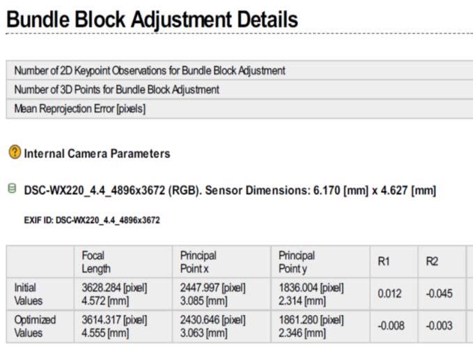
11 The fundamental least square routine that brings all exposures and all image points into one common coordinate system is called the bundle adjustment or aerotriangulation. It uses the principle of collinearity: A ground point, the nodal point of the lens, and its image location lie on a straight line Old school aerotriangulation (1)Unknown exposure stations (duh!) (2)Manual measurement of image points (3)Limited image points due to the slowness of manual measurement (4)Ground control allows one to solve for all exposure (coordinates and 3 rotation angles) and unknown image station positions) Modern bundle adjustment (1)Measured exposure station positions (by GPS) and angles (by IMU) (2)Automated image matching of same point (pixel) on multiple photos no human involved!!! (3) Limited ground control (due to (1)) that is manually measured 11
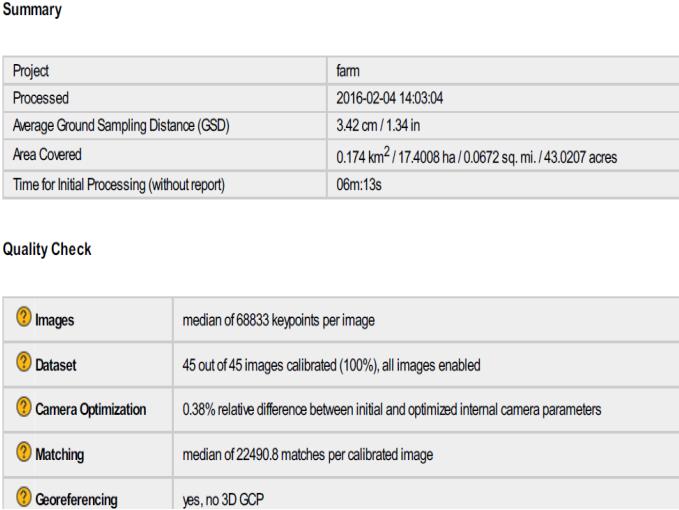
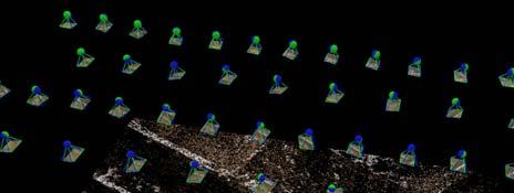
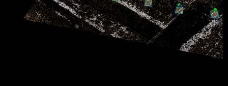
12 Modern bundle adjustment Why does automated image matching work? (1)Due to known camera positions and orientations, and known focal length and image frame size, software can predict where image match points should be (2) These pixel s ROY G. BIV integer image returns are attempted to be matched. If initial guess does not match neighboring pixels are examined for a better match. Modern bundle adjustment Why does automated image matching work? (3) Only excellent matches are used (4) A preliminary bundle adjustment refines the initial GPS IMU positions of exposures they get better (5) With better exposure positions the matching algorithm works better (6) Once matches are found, they are no longer match candidates so the search algorithm has fewer candidates to match on later examinations When the bundle adjustment is complete all exposure stations and image points have been best fit by least squares to fit into one common coordinate system (UTM or state plane normally) Lets look at some results from a 2 flight line job of 45 photos over a large field at the University of Maine under fairly lousy flying conditions (a little foggy as it was 50 degrees in February!!) From arriving at job site to leaving job site the exercise took 20 minutes!!!!!! 12

13 13

14 14
 Orthophotomosaic what a one photo of the entire area would look like except you are looking down at all points, not from a perspective of")
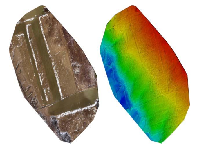
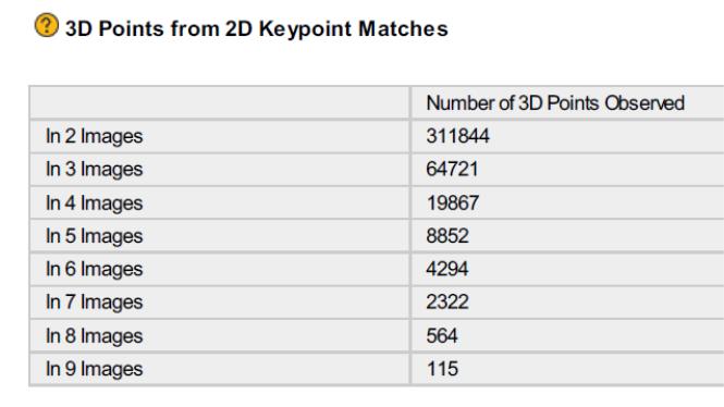
15 Now that you have fallen asleep looking at bundle adjustment statistics: We have mathematical product that is the control survey of photogrammetry now we can create products (1)Point cloud densification very detailed x,y,z on every unique image (2) Orthophotomosaic what a one photo of the entire area would look like except you are looking down at all points, not from a perspective of each individual exposure Point Cloud just a couple of point like more than 6 million! Point cloud also contains the image information for each pixel/each xyz Standard format in industry for point clouds (can be from Lidar, too is binary.las or a.laz which is.las which has been zipped) Note it is so huge it has to be binary as text files take up huge space. Note it contains the image of each x,y,z too! 15
 Example Two football fields at different elevations on one photo will")
 because they have been projected to a common elevation (usually the projection plane through the ellipsoid) What follows (1)Exposures in Map type look (2) Exposures in")
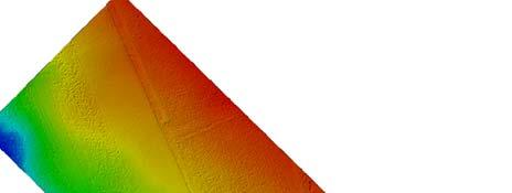
16 Orthophoto Based on initial flying height each 3.43 cm Square is an image with a projection x,y that has been corrected for elevation (relief distortion) Example Two football fields at different elevations on one photo will have different lengths. They will be the same length (300 ft. goal to goal if a ground not grid coor. System) because they have been projected to a common elevation (usually the projection plane through the ellipsoid) What follows (1)Exposures in Map type look (2) Exposures in 3D type look (3)Elevation model (DSM) color coded (4)Job on conventional map (5).las brought into other software (Fugroviewer) and 0.5 m. contours drawn (note the contours need smoothing for production) 16

17 17


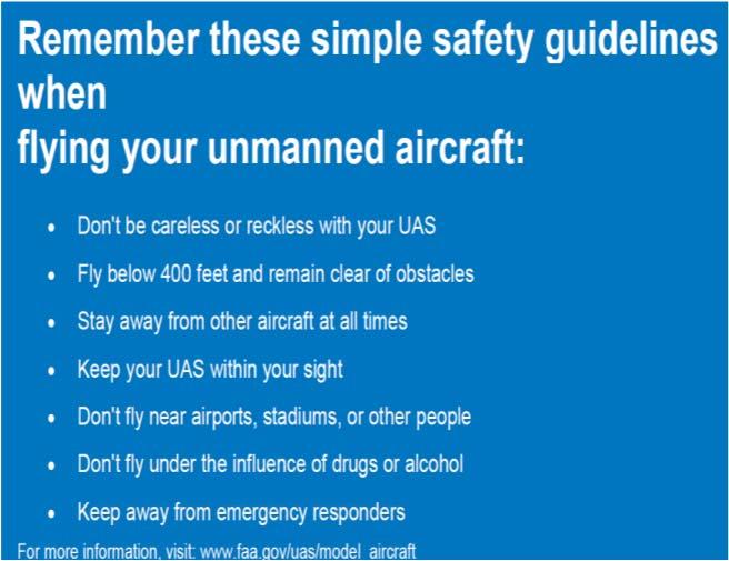
18 Does this controversial in a licensure sense? Check out Here is an interesting article from a drone owner who is providing volume calculations but doesn't feel a survey license is necessary. I think this is a very slippery slope. I don't think our profession is based on our ability to accurately measure alone, but licensure dues help to ensure the public is protected in this area. Here is a case where a user thinks he knows better than the state board because he's a software developer and had done a lot of "quality control." He may be correct and his results may be accurate, but there is little doubt he is probably breaking a surveying law in some states. I think we are going to all be battling this a lot more as the technology becomes more widely available and software easier to use. A joe-schmoe citizen with no education or training in photogrammetry or even ground control, has a $500 drone a whiz-bang software package starts providing a volume calculation (and eventually mapping) to the public. I have very strong opinions about this automated photogrammetry software and its potential for misuse by uninformed drone owners who may over state it's capabilities. I think it poses a legitimate threat to public welfare. Thoughts? FAA things on (could change quickly) (general info) (register a UAV) or_work_business/becoming_a_pilot/ (become a UAS pilot) cs/media/uas_acs.pdf (remote pilot standards) 18
19 FAA things on (could change quickly) est_guides/media/remote_pilot_ktg.pdf (test guide) dbooks_manuals/aviation/media/remote_pil ot_study_guide.pdf (study guide) est_questions/media/uag_sample_exam.pdf (sample test questions) Do I need a regular airplane pilot s license? No, but it is a faster process to become a licensed commercial UAS operator if you do. (request waivers to the rules) (shows why a hobby UAS or an educator is easier to fly than a commercial operation) Pilot Requirements: Must be at least 16 years old Must pass an initial aeronautical knowledge test at an FAA-approved knowledge testing center+ Must be vetted by the Transportation Safety Administration (TSA) +A person who already holds a pilot certificate issued under 14 CFR part 61 and has successfully completed a flight review within the previous 24 months can complete a part 107 online training course at to satisfy this requirement. 19
20 Questions? Maybe no answers!! 20
Fun with Drones Raymond J. Hintz, PLS, PhD University of Maine
 Fun with Drones Raymond J. Hintz, PLS, PhD University of Maine Raymond.hintz@umit.maine.edu 2 types (1)Fixed wing (airplane) -can be cheaper -can be faster and last longer on a battery -Need a take-off
RPAS Photogrammetric Mapping Workflow and Accuracy
 RPAS Photogrammetric Mapping Workflow and Accuracy Dr Yincai Zhou & Dr Craig Roberts Surveying and Geospatial Engineering School of Civil and Environmental Engineering, UNSW Background RPAS category and
UAV PHOTOGRAMMETRY COMPARED TO TRADITIONAL RTK GPS SURVEYING
 UAV PHOTOGRAMMETRY COMPARED TO TRADITIONAL RTK GPS SURVEYING Brad C. Mathison and Amber Warlick March 20, 2016 Fearless Eye Inc. Kansas City, Missouri www.fearlesseye.com KEY WORDS: UAV, UAS, Accuracy
EnsoMOSAIC Aerial mapping tools
 EnsoMOSAIC Aerial mapping tools Jakarta and Kuala Lumpur, 2013 Contents MosaicMill MM Application examples Software introduction System introduction Rikola HS sensor UAV platform examples SW Syst HS UAV
AIRPORT MAPPING JUNE 2016 EXPLORING UAS EFFECTIVENESS GEOSPATIAL SLAM TECHNOLOGY FEMA S ROMANCE WITH LIDAR VOLUME 6 ISSUE 4
 VOLUME 6 ISSUE 4 JUNE 2016 AIRPORT MAPPING 18 EXPLORING UAS EFFECTIVENESS 29 GEOSPATIAL SLAM TECHNOLOGY 36 FEMA S ROMANCE WITH LIDAR Nearly 2,000 U.S. landfill facilities stand to gain from cost-effective
Aerial photography: Principles. Frame capture sensors: Analog film and digital cameras
 Aerial photography: Principles Frame capture sensors: Analog film and digital cameras Overview Introduction Frame vs scanning sensors Cameras (film and digital) Photogrammetry Orthophotos Air photos are
The survey-grade mapping drone
 The survey-grade mapping drone 3 reasons to choose the ebee RTK 01. Survey-grade accuracy Absolute orthomosaic / Digital Elevation Model accuracy of down to 3 cm (1.2 in) without the need for GCPs meaning
Volume 1 - Module 6 Geometry of Aerial Photography. I. Classification of Photographs. Vertical
 RSCC Volume 1 Introduction to Photo Interpretation and Photogrammetry Table of Contents Module 1 Module 2 Module 3.1 Module 3.2 Module 4 Module 5 Module 6 Module 7 Module 8 Labs Volume 1 - Module 6 Geometry
Validation of the QuestUAV PPK System
 Validation of the QuestUAV PPK System 3cm in xy, 400ft, no GCPs, 100Ha, 25 flights Nigel King 1, Kerstin Traut 2, Cameron Weeks 3 & Ruairi Hardman 4 1 Director QuestUAV, 2 Data Analyst QuestUAV, 3 Production
Overview. Objectives. The ultimate goal is to compare the performance that different equipment offers us in a photogrammetric flight.
 Overview At present, one of the most commonly used technique for topographic surveys is aerial photogrammetry. This technique uses aerial images to determine the geometric properties of objects and spatial
Experimental aerial photogrammetry with professional non metric camera Canon EOS 5D
 Experimental aerial photogrammetry with professional non metric camera Canon EOS 5D Ante Sladojević, Goran Mrvoš Galileo Geo Sustavi, Croatia 1. Introduction With this project we wanted to test professional
Introduction to Photogrammetry
 Introduction to Photogrammetry Presented By: Sasanka Madawalagama Geoinformatics Center Asian Institute of Technology Thailand www.geoinfo.ait.asia Content Introduction to photogrammetry 2D to 3D Drones
UAV Technologies for 3D Mapping. Rolf Schaeppi Director Geospatial Solutions APAC / India
 UAV Technologies for 3D Mapping Rolf Schaeppi Director Geospatial Solutions APAC / India Some main application areas? Market situation Analyst statements billion dollars 7,3 defense market 2,5 civil market
Sample Copy. Not For Distribution.
 Photogrammetry, GIS & Remote Sensing Quick Reference Book i EDUCREATION PUBLISHING Shubham Vihar, Mangla, Bilaspur, Chhattisgarh - 495001 Website: www.educreation.in Copyright, 2017, S.S. Manugula, V.
Deliverable 5-B: Review and Update on AURA System Requirements, Sensors, and Platforms Supplemental Report
 Deliverable 5-B: Review and Update on AURA System Requirements, Sensors, and Platforms Supplemental Report Focusing on education, research, and development of technology to sense and understand natural
White Paper Reaching 1 cm (0.4 in) drone survey accuracy
 drone survey accuracy") White Paper Reaching 1 cm (0.4 in) drone survey accuracy 3x higher absolute accuracy with WingtraOne Latest tests in USA and Switzerland prove that the VTOL WingtraOne drone repeatably reaches the best-in-class
White Paper Reaching 1 cm (0.4 in) drone survey accuracy 3x higher absolute accuracy with WingtraOne Latest tests in USA and Switzerland prove that the VTOL WingtraOne drone repeatably reaches the best-in-class
AERIAL SURVEY TEST PROJECT WITH DJI PHANTOM 3 QUADROCOPTER DRONE
 T. Jancso, P. Engler, P. Udvardy Aerial Survey Test Project with DJI Phantom 3 Quadrocopter Drone AERIAL SURVEY TEST PROJECT WITH DJI PHANTOM 3 QUADROCOPTER DRONE Tamas JANCSO, Associate Professor Phd
Lesson 4: Photogrammetry
 This work by the National Information Security and Geospatial Technologies Consortium (NISGTC), and except where otherwise Development was funded by the Department of Labor (DOL) Trade Adjustment Assistance
White Paper Reaching 1 cm (0.4 in) drone survey accuracy
 drone survey accuracy") White Paper Reaching 1 cm (0.4 in) drone survey accuracy 3x higher absolute accuracy with WingtraOne Latest tests in the USA and Switzerland prove that the VTOL WingtraOne drone repeatedly reaches the
White Paper Reaching 1 cm (0.4 in) drone survey accuracy 3x higher absolute accuracy with WingtraOne Latest tests in the USA and Switzerland prove that the VTOL WingtraOne drone repeatedly reaches the
2019 NYSAPLS Conf> Fundamentals of Photogrammetry for Land Surveyors
 2019 NYSAPLS Conf> Fundamentals of Photogrammetry for Land Surveyors George Southard GSKS Associates LLC Introduction George Southard: Master s Degree in Photogrammetry and Cartography 40 years working
The drone for precision agriculture
 The drone for precision agriculture Reap the benefits of scouting crops from above If precision technology has driven the farming revolution of recent years, monitoring crops from the sky will drive the
Phase One 190MP Aerial System
 White Paper Phase One 190MP Aerial System Introduction Phase One Industrial s 100MP medium format aerial camera systems have earned a worldwide reputation for its high performance. They are commonly used
UltraCam and UltraMap Towards All in One Solution by Photogrammetry
 Photogrammetric Week '11 Dieter Fritsch (Ed.) Wichmann/VDE Verlag, Belin & Offenbach, 2011 Wiechert, Gruber 33 UltraCam and UltraMap Towards All in One Solution by Photogrammetry ALEXANDER WIECHERT, MICHAEL
GEO 428: DEMs from GPS, Imagery, & Lidar Tuesday, September 11
 GEO 428: DEMs from GPS, Imagery, & Lidar Tuesday, September 11 Global Positioning Systems GPS is a technology that provides Location coordinates Elevation For any location with a decent view of the sky
Aerial efficiency, photogrammetric accuracy
 Aerial efficiency, photogrammetric accuracy Why sensefly 3 reasons to choose the ebee Plus Large coverage for optimal efficiency The ebee Plus can map more square kilometres per flight, than any drone
Helicopter Aerial Laser Ranging
 Helicopter Aerial Laser Ranging Håkan Sterner TopEye AB P.O.Box 1017, SE-551 11 Jönköping, Sweden 1 Introduction Measuring distances with light has been used for terrestrial surveys since the fifties.
MSB Imagery Program FAQ v1
 MSB Imagery Program FAQ v1 (F)requently (A)sked (Q)uestions 9/22/2016 This document is intended to answer commonly asked questions related to the MSB Recurring Aerial Imagery Program. Table of Contents
Flood modelling and management. Glasgow University. 8 September Paul Shaw - GeoVision
 Flood modelling and management Glasgow University 8 September 2004 Paul Shaw - GeoVision How important are heights in flood modelling? Comparison of data collection technologies GPS - Global Positioning
ACCURACY ASSESSMENT OF DIRECT GEOREFERENCING FOR PHOTOGRAMMETRIC APPLICATIONS ON SMALL UNMANNED AERIAL PLATFORMS
 ACCURACY ASSESSMENT OF DIRECT GEOREFERENCING FOR PHOTOGRAMMETRIC APPLICATIONS ON SMALL UNMANNED AERIAL PLATFORMS O. Mian a, J. Lutes a, G. Lipa a, J. J. Hutton a, E. Gavelle b S. Borghini c * a Applanix
PHOTOGRAMMETRY STEREOSCOPY FLIGHT PLANNING PHOTOGRAMMETRIC DEFINITIONS GROUND CONTROL INTRODUCTION
 PHOTOGRAMMETRY STEREOSCOPY FLIGHT PLANNING PHOTOGRAMMETRIC DEFINITIONS GROUND CONTROL INTRODUCTION Before aerial photography and photogrammetry became a reliable mapping tool, planimetric and topographic
HIGH RESOLUTION COLOR IMAGERY FOR ORTHOMAPS AND REMOTE SENSING. Author: Peter Fricker Director Product Management Image Sensors
 HIGH RESOLUTION COLOR IMAGERY FOR ORTHOMAPS AND REMOTE SENSING Author: Peter Fricker Director Product Management Image Sensors Co-Author: Tauno Saks Product Manager Airborne Data Acquisition Leica Geosystems
Processing of stereo scanner: from stereo plotter to pixel factory
 Photogrammetric Week '03 Dieter Fritsch (Ed.) Wichmann Verlag, Heidelberg, 2003 Bignone 141 Processing of stereo scanner: from stereo plotter to pixel factory FRANK BIGNONE, ISTAR, France ABSTRACT With
HD aerial video for coastal zone ecological mapping
 HD aerial video for coastal zone ecological mapping Albert K. Chong University of Otago, Dunedin, New Zealand Phone: +64 3 479-7587 Fax: +64 3 479-7586 Email: albert.chong@surveying.otago.ac.nz Presented
An Introduction to Geomatics. Prepared by: Dr. Maher A. El-Hallaq خاص بطلبة مساق مقدمة في علم. Associate Professor of Surveying IUG
 An Introduction to Geomatics خاص بطلبة مساق مقدمة في علم الجيوماتكس Prepared by: Dr. Maher A. El-Hallaq Associate Professor of Surveying IUG 1 Airborne Imagery Dr. Maher A. El-Hallaq Associate Professor
Baldwin and Mobile Counties, AL Orthoimagery Project Report. Submitted: March 23, 2016
 2015 Orthoimagery Project Report Submitted: Prepared by: Quantum Spatial, Inc 523 Wellington Way, Suite 375 Lexington, KY 40503 859-277-8700 Page i of iii Contents Project Report 1. Summary / Scope...
White Paper Reaching 1 cm (0.4 in) drone survey accuracy
 drone survey accuracy") White Paper Reaching 1 cm (0.4 in) drone survey accuracy 3x higher absolute accuracy with WingtraOne Latest tests in USA and Switzerland prove that the VTOL WingtraOne drone repeatably reaches the best-in-class
White Paper Reaching 1 cm (0.4 in) drone survey accuracy 3x higher absolute accuracy with WingtraOne Latest tests in USA and Switzerland prove that the VTOL WingtraOne drone repeatably reaches the best-in-class
Some Notes on Using Balloon Photography For Modeling the Landslide Area
 Some Notes on Using Balloon Photography For Modeling the Landslide Area Catur Aries Rokhmana Department of Geodetic-Geomatics Engineering Gadjah Mada University Grafika No.2 Yogyakarta 55281 - Indonesia
Five Sensors, One Day: Unmanned vs. Manned Logistics and Accuracy
 Five Sensors, One Day: Unmanned vs. Manned Logistics and Accuracy ASPRS UAS Mapping Technical Symposium Sept 13 th, 2016 Presenter: David Day, CP, GISP Keystone Aerial Surveys, Inc. Summary of activities
VisionMap A3 Edge A Single Camera for Multiple Solutions
 Photogrammetric Week '15 Dieter Fritsch (Ed.) Wichmann/VDE Verlag, Belin & Offenbach, 2015 Raizman, Gozes 57 VisionMap A3 Edge A Single Camera for Multiple Solutions Yuri Raizman, Adi Gozes, Tel-Aviv ABSTRACT
Aerial Image Acquisition and Processing Services. Ron Coutts, M.Sc., P.Eng. RemTech, October 15, 2014
 Aerial Image Acquisition and Processing Services Ron Coutts, M.Sc., P.Eng. RemTech, October 15, 2014 Outline Applications & Benefits Image Sources Aircraft Platforms Image Products Sample Images & Comparisons
Photogrammetry. Lecture 4 September 7, 2005
 Photogrammetry Lecture 4 September 7, 2005 What is Photogrammetry Photogrammetry is the art and science of making accurate measurements by means of aerial photography: Analog photogrammetry (using films:
Introduction to Remote Sensing Lab 6 Dr. Hurtado Wed., Nov. 28, 2018
 Lab 6: UAS Remote Sensing Due Wed., Dec. 5, 2018 Goals 1. To learn about the operation of a small UAS (unmanned aerial system), including flight characteristics, mission planning, and FAA regulations.
Photomod Lite Contest 2013 Creating vegetation map using UAV at Seaside Palouki forest (Greece) by Apostolos Nteris
 by Apostolos Nteris") P r o j e c t I n f o r m a t i o n Title: Creating vegetation map using UAV at seaside Palouki forest (Greece) Author: Apostolos Nteris, Surveyor engineer OLYZON consulting - Trikala Greece Contact: Apostolos
P r o j e c t I n f o r m a t i o n Title: Creating vegetation map using UAV at seaside Palouki forest (Greece) Author: Apostolos Nteris, Surveyor engineer OLYZON consulting - Trikala Greece Contact: Apostolos
CHARLES MONDELLO PAST PRESIDENT PDC ASPRS FELLOW
 SMALL UNMANNED AERIAL SYSTEMS (SUAS) IN EMERGENCY MANAGEMENT RANDY FRANK MARION COUNTY DIRECTOR EMERGENCY MANAGEMENT CHARLES MONDELLO PAST PRESIDENT PDC ASPRS FELLOW SUAS OR DRONE OR UAV 1) Small Unmanned
Assessing the Accuracy of Ortho-image using Photogrammetric Unmanned Aerial System
 Assessing the Accuracy of Ortho-image using Photogrammetric Unmanned Aerial System H. H. Jeong a, J. W. Park a, J. S. Kim a, C. U. Choi a, * a Dept. of Spatial Information Engineering, Pukyong National
Drones and Ham Radio. Bob Schatzman KD9AAD
 Drones and Ham Radio Bob Schatzman KD9AAD Not Your Childhood RC Toy! Highly Accurate GPS receiver! Magnetic Compass! R/C Transmitter/Receiver! Accelerometers/Gyros! HDTV & HQ Still Camera on a Smart Gimbal!
SENSITIVITY ANALYSIS OF UAV-PHOTOGRAMMETRY FOR CREATING DIGITAL ELEVATION MODELS (DEM)
") SENSITIVITY ANALYSIS OF UAV-PHOTOGRAMMETRY FOR CREATING DIGITAL ELEVATION MODELS (DEM) G. Rock a, *, J.B. Ries b, T. Udelhoven a a Dept. of Remote Sensing and Geomatics. University of Trier, Behringstraße,
SENSITIVITY ANALYSIS OF UAV-PHOTOGRAMMETRY FOR CREATING DIGITAL ELEVATION MODELS (DEM) G. Rock a, *, J.B. Ries b, T. Udelhoven a a Dept. of Remote Sensing and Geomatics. University of Trier, Behringstraße,
[GEOMETRIC CORRECTION, ORTHORECTIFICATION AND MOSAICKING]
![[GEOMETRIC CORRECTION, ORTHORECTIFICATION AND MOSAICKING]](/thumbs/78/78211997.jpg "[GEOMETRIC CORRECTION, ORTHORECTIFICATION AND MOSAICKING]") 2013 Ogis-geoInfo Inc. IBEABUCHI NKEMAKOLAM.J [GEOMETRIC CORRECTION, ORTHORECTIFICATION AND MOSAICKING] [Type the abstract of the document here. The abstract is typically a short summary of the contents
2013 Ogis-geoInfo Inc. IBEABUCHI NKEMAKOLAM.J [GEOMETRIC CORRECTION, ORTHORECTIFICATION AND MOSAICKING] [Type the abstract of the document here. The abstract is typically a short summary of the contents
High Fidelity 3D Reconstruction
 High Fidelity 3D Reconstruction Adnan Ansar, California Institute of Technology KISS Workshop: Gazing at the Solar System June 17, 2014 Copyright 2014 California Institute of Technology. U.S. Government
Geo-localization and Mosaicing System (GEMS): Enabling Precision Image Feature Location and Rapid Mosaicing General:
: Enabling Precision Image Feature Location and Rapid Mosaicing General:") Geo-localization and Mosaicing System (GEMS): Enabling Precision Image Feature Location and Rapid Mosaicing General: info@senteksystems.com www.senteksystems.com 12/6/2014 Precision Agriculture Multi-Spectral
Geo-localization and Mosaicing System (GEMS): Enabling Precision Image Feature Location and Rapid Mosaicing General: info@senteksystems.com www.senteksystems.com 12/6/2014 Precision Agriculture Multi-Spectral
ASPECTS OF DEM GENERATION FROM UAS IMAGERY
 ASPECTS OF DEM GENERATION FROM UAS IMAGERY A. Greiwea,, R. Gehrke a,, V. Spreckels b,, A. Schlienkamp b, Department Architecture, Civil Engineering and Geomatics, Fachhochschule Frankfurt am Main, Germany
Leica ADS80 - Digital Airborne Imaging Solution NAIP, Salt Lake City 4 December 2008
 Luzern, Switzerland, acquired at 5 cm GSD, 2008. Leica ADS80 - Digital Airborne Imaging Solution NAIP, Salt Lake City 4 December 2008 Shawn Slade, Doug Flint and Ruedi Wagner Leica Geosystems AG, Airborne
accuracy. You even hear the terms subcentimeter or even millimeter absolute accuracy during some of these
 Question: I would like to get your expert opinion on a dataset I just received. It is UAS-based imagery collected to produce a 50cm Digital Elevation Models (DEM) and 5cm resolution true color orthos.
22/11/2013. UAV: Overview of systems, applications and processing Kris Nackaerts, Peter Strigencz
 22/11/2013 UAV: Overview of systems, applications and processing Kris Nackaerts, Peter Strigencz Introduction» Systems» Applications» Non-imaging» Imaging» Processing, focus on photogrammetry» Use case
High Resolution Sensor Test Comparison with SPOT, KFA1000, KVR1000, IRS-1C and DPA in Lower Saxony
 High Resolution Sensor Test Comparison with SPOT, KFA1000, KVR1000, IRS-1C and DPA in Lower Saxony K. Jacobsen, G. Konecny, H. Wegmann Abstract The Institute for Photogrammetry and Engineering Surveys
not to be republished NCERT Introduction To Aerial Photographs Chapter 6
 Chapter 6 Introduction To Aerial Photographs Figure 6.1 Terrestrial photograph of Mussorrie town of similar features, then we have to place ourselves somewhere in the air. When we do so and look down,
RESEARCH ON LOW ALTITUDE IMAGE ACQUISITION SYSTEM
 RESEARCH ON LOW ALTITUDE IMAGE ACQUISITION SYSTEM 1, Hongxia Cui, Zongjian Lin, Jinsong Zhang 3,* 1 Department of Information Science and Engineering, University of Bohai, Jinzhou, Liaoning Province,11,
Unmanned Aerial Vehicle Data Acquisition for Damage Assessment in. Hurricane Events
 Unmanned Aerial Vehicle Data Acquisition for Damage Assessment in Hurricane Events Stuart M. Adams a Carol J. Friedland b and Marc L. Levitan c ABSTRACT This paper examines techniques for data collection
The survey-grade mapping drone
 The survey-grade mapping drone +380,000 +110,000 +19,000,000 FLIGHTS TO DATE FLIGHT HOURS HA COVERAGE 3 reasons to choose the ebee RTK Survey-grade accuracy Fully integrated workflow Compatible with existing
Classical Control Based Autopilot Design Using PC/104
 Classical Control Based Autopilot Design Using PC/104 Mohammed A. Elsadig, Alneelain University, Dr. Mohammed A. Hussien, Alneelain University. Abstract Many recent papers have been written in unmanned
sensefly Camera Collection
 Camera Collection A professional sensor for every application Introducing S.O.D.A. 3D 3D mapping, redefined Image: S.O.D.A. 3D oblique image (left) merging into 3D mesh (right). Stunning digital 3D reconstructions
MULTISPECTRAL AGRICULTURAL ASSESSMENT. Normalized Difference Vegetation Index. Federal Robotics INSPECTION & DOCUMENTATION
 MULTISPECTRAL AGRICULTURAL ASSESSMENT Normalized Difference Vegetation Index INSPECTION & DOCUMENTATION Federal Robotics Clearwater Dr. Amherst, New York 14228 716-221-4181 Sales@FedRobot.com www.fedrobot.com
Free Flight Mapping: Pix4Dcapture & dji Spark Jerry Davis, SFSU Institute for Geographic Information Science
 Free Flight Mapping: Pix4Dcapture & dji Spark Jerry Davis, SFSU Institute for Geographic Information Science The best way to do mapping is using a GPS guided grid pattern programmed by an app like Tower
Heterogeneous Control of Small Size Unmanned Aerial Vehicles
 Magyar Kutatók 10. Nemzetközi Szimpóziuma 10 th International Symposium of Hungarian Researchers on Computational Intelligence and Informatics Heterogeneous Control of Small Size Unmanned Aerial Vehicles
Technical information about PhoToPlan
 Technical information about PhoToPlan The following pages shall give you a detailed overview of the possibilities using PhoToPlan. kubit GmbH Fiedlerstr. 36, 01307 Dresden, Germany Fon: +49 3 51/41 767
PHOTOGRAMMETRIC RESECTION DIFFERENCES BASED ON LABORATORY vs. OPERATIONAL CALIBRATIONS
 PHOTOGRAMMETRIC RESECTION DIFFERENCES BASED ON LABORATORY vs. OPERATIONAL CALIBRATIONS Dean C. MERCHANT Topo Photo Inc. Columbus, Ohio USA merchant.2@osu.edu KEY WORDS: Photogrammetry, Calibration, GPS,
VisionMap Sensors and Processing Roadmap
 Vilan, Gozes 51 VisionMap Sensors and Processing Roadmap YARON VILAN, ADI GOZES, Tel-Aviv ABSTRACT The A3 is a family of digital aerial mapping cameras and photogrammetric processing systems, which is
EXAMPLES OF TOPOGRAPHIC MAPS PRODUCED FROM SPACE AND ACHIEVED ACCURACY CARAVAN Workshop on Mapping from Space, Phnom Penh, June 2000
 EXAMPLES OF TOPOGRAPHIC MAPS PRODUCED FROM SPACE AND ACHIEVED ACCURACY CARAVAN Workshop on Mapping from Space, Phnom Penh, June 2000 Jacobsen, Karsten University of Hannover Email: karsten@ipi.uni-hannover.de
Drones for Telecommunications
 April 6, 2017 Drones for Telecommunications How AT&T uses drones to support and enhance its network Art Pregler AT&T UAS Program Director 2017 AT&T Intellectual Property. All rights reserved. AT&T, Globe
MEDIUM FORMAT CAMERA EVALUATION BASED ON THE LATEST PHASE ONE TECHNOLOGY
 MEDIUM FORMAT CAMERA EVALUATION BASED ON THE LATEST PHASE ONE TECHNOLOGY T.Tölg a, G. Kemper b, D. Kalinski c a Phase One / Germany tto@phaseone.com b GGS GmbH, Speyer / Germany kemper@ggs-speyer.de c
A New Capability for Crash Site Documentation
 A New Capability for Crash Site Documentation By Major Adam Cybanski, Directorate of Flight Safety, Ottawa Major Adam Cybanski is the officer responsible for helicopter investigation (DFS 2-4) at the Canadian
PEGASUS : a future tool for providing near real-time high resolution data for disaster management. Lewyckyj Nicolas
 PEGASUS : a future tool for providing near real-time high resolution data for disaster management Lewyckyj Nicolas nicolas.lewyckyj@vito.be http://www.pegasus4europe.com Overview Vito in a nutshell GI
Phase One ixu-rs1000 Accuracy Assessment Report Yu. Raizman, PhaseOne.Industrial, Israel
 17 th International Scientific and Technical Conference FROM IMAGERY TO DIGITAL REALITY: ERS & Photogrammetry Phase One ixu-rs1000 Accuracy Assessment Report Yu. Raizman, PhaseOne.Industrial, Israel 1.
OughtToPilot. Project Report of Submission PC128 to 2008 Propeller Design Contest. Jason Edelberg
 OughtToPilot Project Report of Submission PC128 to 2008 Propeller Design Contest Jason Edelberg Table of Contents Project Number.. 3 Project Description.. 4 Schematic 5 Source Code. Attached Separately
CSI: Rombalds Moor Photogrammetry Photography
 Photogrammetry Photography Photogrammetry Training 26 th March 10:00 Welcome Presentation image capture Practice 12:30 13:15 Lunch More practice 16:00 (ish) Finish or earlier What is photogrammetry 'photo'
IGI Ltd. Serving the Aerial Survey Industry for more than 20 Years
 'Photogrammetric Week 05' Dieter Fritsch, Ed. Wichmann Verlag, Heidelberg 2005. Kremer 33 IGI Ltd. Serving the Aerial Survey Industry for more than 20 Years JENS KREMER, Kreuztal ABSTRACT Since 1982 IGI
Visual inspection strategies for large bridges using Unmanned Aerial Vehicles (UAV)
") Visual inspection strategies for large bridges using Unmanned Aerial Vehicles (UAV) Norman Hallermann & Guido Morgenthal Bauhaus-Universität Weimar, Chair of Modeling and Simulation of Structures, Weimar,
Visual inspection strategies for large bridges using Unmanned Aerial Vehicles (UAV) Norman Hallermann & Guido Morgenthal Bauhaus-Universität Weimar, Chair of Modeling and Simulation of Structures, Weimar,
Some Enhancement in Processing Aerial Videography Data for 3D Corridor Mapping
 Some Enhancement in Processing Aerial Videography Data for 3D Corridor Mapping Catur Aries ROKHMANA, Indonesia Key words: 3D corridor mapping, aerial videography, point-matching, sub-pixel enhancement,
UAS Photogrammetry Best Practices
 UAS Photogrammetry Best Practices Pennsylvania Society of Land Surveyors January 15, 2019 Bryan Baker Certified Mapping Scientist (UAS) Bryan Baker UAS Sales Manager Leica Geosystems Reality Capture Team
Geometry of Aerial Photographs
 Geometry of Aerial Photographs Aerial Cameras Aerial cameras must be (details in lectures): Geometrically stable Have fast and efficient shutters Have high geometric and optical quality lenses They can
NREM 345 Week 2, Material covered this week contributes to the accomplishment of the following course goal:
 NREM 345 Week 2, 2010 Reading assignment: Chapter. 4 and Sec. 5.1 to 5.2.4 Material covered this week contributes to the accomplishment of the following course goal: Goal 1: Develop the understanding and
Calibration Certificate
 Calibration Certificate Digital Mapping Camera (DMC) DMC Serial Number: DMC01-0053 CBU Serial Number: 0100053 For MPPG AERO Sp. z. o. o., ul. Kaczkowskiego 6 33-100 Tarnow Poland System Overview Flight
Mapping with the Phantom 4 Advanced & Pix4Dcapture Jerry Davis, Institute for Geographic Information Science, San Francisco State University
 Mapping with the Phantom 4 Advanced & Pix4Dcapture Jerry Davis, Institute for Geographic Information Science, San Francisco State University The DJI Phantom 4 is a popular, easy to fly UAS that integrates
Lecture # 7 Coordinate systems and georeferencing
 Lecture # 7 Coordinate systems and georeferencing Coordinate Systems Coordinate reference on a plane Coordinate reference on a sphere Coordinate reference on a plane Coordinates are a convenient way of
MINNESOTA DEPARTMENT OF TRANSPORTATION OFFICE OF LAND MANAGEMENT SURVEYING AND MAPPING SECTION PHOTOGRAMMETRY UNIT
 SEP. 2011 MINNESOTA DEPARTMENT OF TRANSPORTATION OFFICE OF LAND MANAGEMENT SURVEYING AND MAPPING SECTION PHOTOGRAMMETRY UNIT SPECIAL PROVISIONS FOR: GROUP 1: AERIAL PHOTOGRAPHY/PHOTOGRAMMETRIC LAB SERVICES
USE OF IMPROVISED REMOTELY SENSED DATA FROM UAV FOR GIS AND MAPPING, A CASE STUDY OF GOMA CITY, DR CONGO
 USE OF IMPROVISED REMOTELY SENSED DATA FROM UAV FOR GIS AND MAPPING, A CASE STUDY OF GOMA CITY, DR CONGO Cung Chin Thang United Nations Global Support Center, Brindisi, Italy, Email: thang@un.org KEY WORDS:
Lecture 7. Leica ADS 80 Camera System and Imagery. Ontario ADS 80 FRI Imagery. NRMT 2270, Photogrammetry/Remote Sensing
 NRMT 2270, Photogrammetry/Remote Sensing Lecture 7 Leica ADS 80 Camera System and Imagery. Ontario ADS 80 FRI Imagery. Tomislav Sapic GIS Technologist Faculty of Natural Resources Management Lakehead University
Basics of Photogrammetry Note#6
 Basics of Photogrammetry Note#6 Photogrammetry Art and science of making accurate measurements by means of aerial photography Analog: visual and manual analysis of aerial photographs in hard-copy format
Leica - 3 rd Generation Airborne Digital Sensors Features / Benefits for Remote Sensing & Environmental Applications
 Leica - 3 rd Generation Airborne Digital Sensors Features / Benefits for Remote Sensing & Environmental Applications Arthur Rohrbach, Sensor Sales Dir Europe, Middle-East and Africa (EMEA) Luzern, Switzerland,
Chapters 1 & 2. Definitions and applications Conceptual basis of photogrammetric processing
 Chapters 1 & 2 Chapter 1: Photogrammetry Definitions and applications Conceptual basis of photogrammetric processing Transition from two-dimensional imagery to three-dimensional information Automation
IMAGE ACQUISITION GUIDELINES FOR SFM
 IMAGE ACQUISITION GUIDELINES FOR SFM a.k.a. Close-range photogrammetry (as opposed to aerial/satellite photogrammetry) Basic SfM requirements (The Golden Rule): minimum of 60% overlap between the adjacent
ENVI Tutorial: Orthorectifying Aerial Photographs
 ENVI Tutorial: Orthorectifying Aerial Photographs Table of Contents OVERVIEW OF THIS TUTORIAL...2 ORTHORECTIFYING AERIAL PHOTOGRAPHS IN ENVI...2 Building the interior orientation...3 Building the exterior
INVESTIGATION OF PHOTOTRIANGULATION ACCURACY WITH USING OF VARIOUS TECHNIQUES LABORATORY AND FIELD CALIBRATION
 INVESTIGATION OF PHOTOTRIANGULATION ACCURACY WITH USING OF VARIOUS TECHNIQUES LABORATORY AND FIELD CALIBRATION A. G. Chibunichev 1, V. M. Kurkov 1, A. V. Smirnov 1, A. V. Govorov 1, V. A. Mikhalin 2 *
KEY WORDS: Animation, Architecture, Image Rectification, Multi-Media, Texture Mapping, Visualization
 AUTOMATED PROCESSING OF DIGITAL IMAGE DATA IN ARCHITECTURAL SURVEYING Günter Pomaska Prof. Dr.-Ing., Faculty of Architecture and Civil Engineering FH Bielefeld, University of Applied Sciences Artilleriestr.
Capture the invisible
 Capture the invisible A Capture the invisible The Sequoia multispectral sensor captures both visible and invisible images, providing calibrated data to optimally monitor the health and vigor of your crops.
SCIENCE & TECHNOLOGY
 Pertanika J. Sci. & Technol. 21 (2): 387-396 (2013) SCIENCE & TECHNOLOGY Journal homepage: http://www.pertanika.upm.edu.my/ Production of Orthophoto and Volume Determination Using Low-Cost Digital Cameras
DatuGram 2D. User Guide. Version 2.0 August Datumate Geomatics Expert Systems
 DatuGram 2D User Guide Version 2.0 August 2013 Datumate Geomatics Expert Systems Using DatuGram, land surveying is made easier, faster and with excellent geodetic accuracy. For more information please
Project Planning and Cost Estimating
 CHAPTER 17 Project Planning and Cost Estimating 17.1 INTRODUCTION Previous chapters have outlined and detailed technical aspects of photogrammetry. The basic tasks and equipment required to create various
MULTIPURPOSE QUADCOPTER SOLUTION FOR AGRICULTURE
 MULTIPURPOSE QUADCOPTER SOLUTION FOR AGRICULTURE Powered by COVERS UP TO 30HA AT 70M FLIGHT ALTITUDE PER BATTERY PHOTO & VIDEO FULL HD 1080P - 14MP 3-AXIS STABILIZATION INCLUDES NDVI & ZONING MAPS SERVICE
Close-Range Photogrammetry for Accident Reconstruction Measurements
 Close-Range Photogrammetry for Accident Reconstruction Measurements iwitness TM Close-Range Photogrammetry Software www.iwitnessphoto.com Lee DeChant Principal DeChant Consulting Services DCS Inc Bellevue,