MSRC Tactical Oil Spill Surveillance and Remote Sensing
|
|
|
- Hilary Shields
- 5 years ago
- Views:
Transcription
1 MSRC Tactical Oil Spill Surveillance and Remote Sensing Industry Technical Advisory Committee for Oil spill Response October 25,
2 Historical Perspective -- Oil Spill Surveillance in U.S Exxon Valdez Gulf Hurricanes of mid-2000 period Deepwater Horizon Strategic Surveillance Satellite - Optical - Radar (detection mapping) Strategic COP Enhanced satellite imagery Relative thickness mapping (delayed basis) Limited tactical value Tactical Surveillance Visual Aerial Spotting - Eye - Photography - Video Tactical Surveillance Same reliance on visual Day light only Boat positioning challenges Thickest Oil False Targets Compressed Window (Daylight positioning) 1


3 Provoking Questions: Where would we want to position a Responding OSRV? More importantly --- How do we do it? Inefficient Recovery Maximal Recovery Inefficient recovery Maximal recovery 2

4 Post DWH Observations Surveillance Timely operating decisions Earlier recognition of where to position/ reposition assets as oil moves Distinguishing recoverable vs. sheen Key to response efficiency Avoiding false targets Expanding operating window beyond daylight 3
5 Post DWH Observations Surveillance Challenges Oil/Water fingerprints are complex -- more so than human targets No single sensor provides all answers Some only work in daylight (optical/near visual) Technical Challenges Some only provide detection Do not distinguish recoverable targets vs. sheen (radar/most satellite images) Some do not work through clouds or humidity (thermal infrared) 4
6 MSRC Taking Surveillance To New Levels Exxon Valdez Gulf Hurricanes of mid-2000 period Deepwater Horizon Since Deepwater Horizon Strategic Surveillance Satellite - Optical - Radar (detection mapping) Tactical Surveillance Visual Aerial Spotting - Eye - Photography - Video Strategic COP Enhanced satellite imagery Relative thickness mapping (delayed basis) Tactical Surveillance Same reliance on visual Day light only MSRC Systems Approach Tactical Priority With Strategic Application Level V Visual Non dedicated aircraft Level A Aircraft Non dedicated with sensors Level B Balloons/Tethered with sensors Level C Close-in ship-mounted with sensors Level D Drones/sUAS with sensors Level S Satellite (Pending) 5
7 MSRC Level V -- Visual Regulatory Requirement OSROs provides this capability with Aircraft of Opportunity (AOO) to meet Federal regulations MSRC has enhanced this capability with our Visual Observation Report (VOR) Internally developed ipad app o Combined use of camera (video and still) o Integrated geo-referencing information o ASTM and NOAA documentation templates 6


8 MSRC Visual Observation Report (VOR)

9 MSRC Visual Observation Report (VOR)

 Multi-spectral (color not")
10 Level A -- Aircraft Using Ocean Imaging TRACS System Pre-identified Aircraft of Opportunity Audited operating standards Appropriate ports to utilize TRACS system High height of eye with 24-hr operations potential ~500 to ~12,500 Fast speed of advance ( mph) Three dedicated TRACS systems Operated by trained MSRC personnel Located in Edison, NJ; Houston, TX; and Long Beach, CA Sensors Thermal Infrared (TIR) Multi-spectral (color not seen with eye) 9
 Fully Processed Oil Distribution Mapping by Ocean Imaging for COP purposes 10")
11 Level A -- Aircraft Using Ocean Imaging TRACS System System mounted with pre-engineered adapter plates on airplane floor porthole Tactical real-time imagery MSRC developed WiFi network for image transfer to Recovery vessels (up to several miles) Fully Processed Oil Distribution Mapping by Ocean Imaging for COP purposes 10


12 Example: Visual vs. Digital Imaging of a Slick Visual or Photo OI Sensor: Visual Multispectral OI Sensor: Thermal Source: Ocean Imaging,

13 MSRC Level A -- Imagery Example MSRC/Ocean Imaging Training Flight Natural Seeps, Platform Holly Santa Barbara, CA March 12, 2014 Standard digital photo representative of a visual observers view 12


14 MSRC Level A Imagery Imagery from Multi-spectral Camera Imagery from Thermal IR Camera MSRC/Ocean Imaging Training Flight Santa Barbara, CA March 12, 2014 Fully Processed Oil Distribution Map 13

15 MSRC Level B Tethered Balloon (Aerostat) Battery powered Up to 12-hour hang time Rechargeable battery Package includes: HD Camera TIR Camera AIS Repeater NOFO: OOW 12 Small, compact easily transportable package Proprietary viewing software and gimbal WiFi transfer to host vessel 14


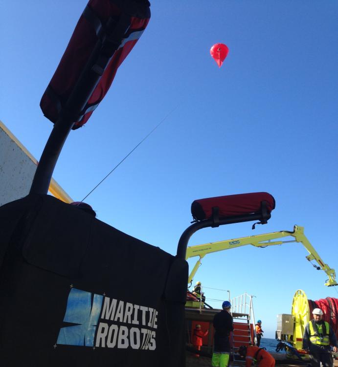
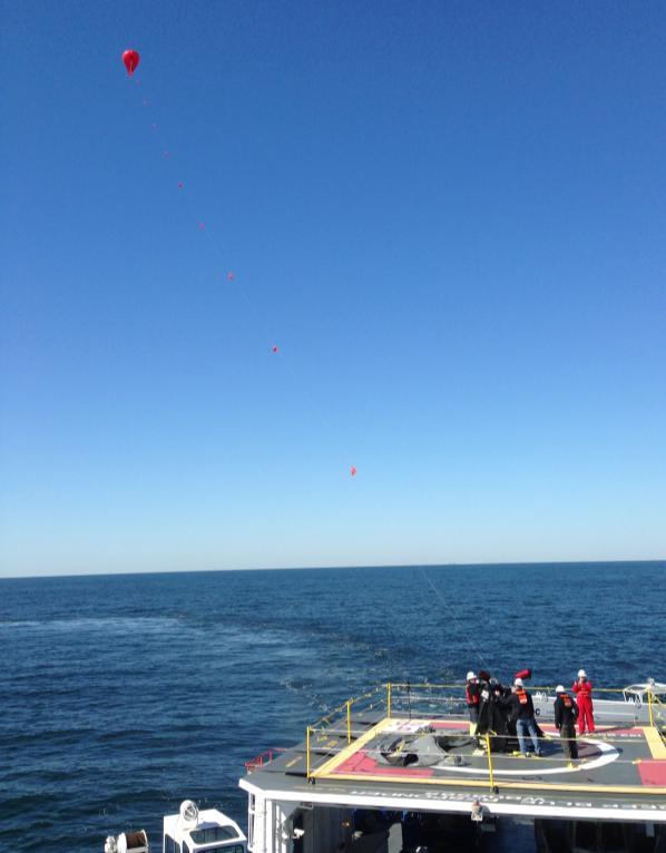
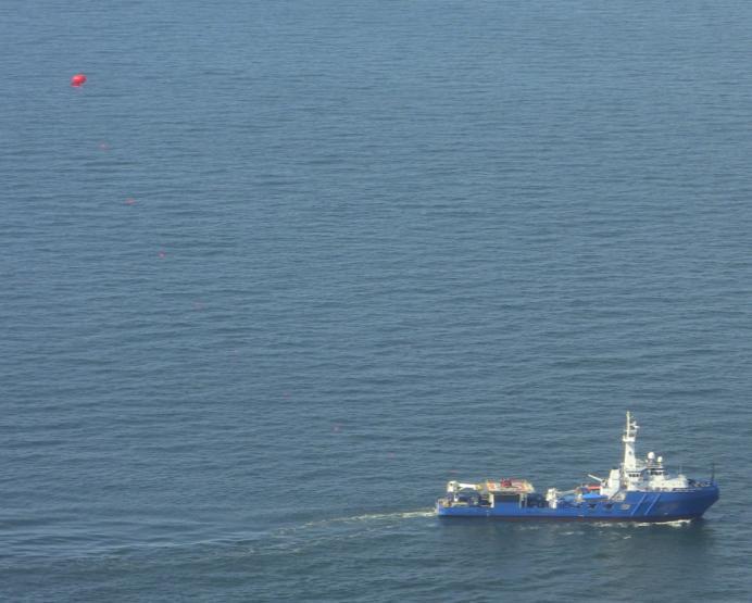
16 MSRC Level B Balloons (Aerostats) Deep Blue Responder /23/


17 MSRC Level B Imagery Examples Viewing: IR/HD Image Fusion ~75% IR overlaid with ~25% HD Visual


18 MSRC Level C -- Close In Vessel Mounted Systems for Tactical Optimization (NOFO OOW 13) Oil X Band Radar Oil Detection Infra-Red: Thermal Infrared Camera Mounted On Crow s Nest Of MSRC Responder Class OSRV Imagery From Camera Allowing Spill Responders To Optimize Recovery 17


19 MSRC Level C -- Close-In Containerized X Band/TIR Transportable Containers For Use with Barges and Large Vessels of Opportunity 18
20 MSRC Level D -- Drones/sUAS Current regulations Day time operations only Must maintain line of sight Certified pilot required Section 333 permit holders have blanket authorization up to 400 feet altitude subject to: Distance from airports or helipads Depends on flight rules and operational control towers Restriction ranges from 2-5 NM from airport or helipads 19
 and Infrared Nationwide coverage through individual Areas of Interest Most likely used for near shore and shoreline assessment o SCAT priorities")
21 MSRC Level D -- Drones/sUAS Pre-established contracts with four operators Pre-vetted capabilities (demonstrated raw videos, screen shots, and mosaics) Both fixed wing and rotary Optical (HD Video) and Infrared Nationwide coverage through individual Areas of Interest Most likely used for near shore and shoreline assessment o SCAT priorities 20
22 MSRC Level S Satellite (Pending) Primarily for general oil spill mapping (Common Operating Picture Typically optical and radar (detection) images Pre-established boilerplate terms and conditions to expedite use at time of spill Working with two satellite providers 21
23 Airplane Or Helicopter MSRC Level V Visual Incident Management Over-flight Assessment (ipad App) Initial On Water Asset Deployment On-going On Water Asset Deployment Airplane (AOO) Suitable For Ocean Imaging TRACS System Large Swath Surveillance Tactical Operations Real Time Remote Sensing Tactical Decisions Oil Thickness Distribution Mapping Common Operating Picture (COP) MSRC Level A OSRV Or Other Platform (Tethered Balloon/Aerost at) MSRC Level B Close-In Ship Mounted Sensors MSRC Level C Mid Swath Surveillance Move with Oil Day or Night Positioning On Water Asset Recovery Optimization On Water Asset Deployment Drones (suas) MSRC Level D MSRC Developed WiFi Data Transfer Prime For Hard To Access Areas (Near shore/shorelin e) Primarily Optical and Radar Detection of Oil MSRC Level S
24 Summary A concluding quote from the December 2012 API JITF report on Remote Sensing In Support of Oil Spill Response Planning Guidance: Spill response readiness must be actively managed to ensure that the capabilities, technologies, infrastructure, and logistics are in place and that they are sustained, ready, and continuously improved. The report emphasized the need for a prominent role in the Incident Command Structure MSRC has developed an industry-unique systems approach Multi-platform, multi-sensor capability Comprehensive knowledge of oil surveillance through our internal 17 employee strike team 23
TRACS A-B-C Acquisition and Processing and LandSat TM Processing
 TRACS A-B-C Acquisition and Processing and LandSat TM Processing Mark Hess, Ocean Imaging Corp. Kevin Hoskins, Marine Spill Response Corp. TRACS: Level A AIRCRAFT Ocean Imaging Corporation Multispectral/TIR
Phone:
 Derek Burrage (P.I. & Technical lead/poc), Sonia Gallegos, Joel Wesson, Richard Gould, and Sean McCarthy Oceanography Division, Ocean Sciences Branch, Naval Research Lab., Stennis Space Center, MS, USA
Sensors, Tools and the Common Operating Picture. Sensors, Tools and the Common Operating Picture 14 th April Middleburg
 Sensors, Tools and the Common Operating Picture 14 th April 2015 - Middleburg Aptomar Established in 2005 Owned by Statoil, Investinor, Proventure Seed, Verdane Capitol Have developed and control all IPR
Deepwater Horizon Mechanical Recovery System Evaluation Interim Report
 Deepwater Horizon Mechanical Recovery System Evaluation Interim Report API TECHNICAL REPORT 1143 SEPTEMBER 2013 Special Notes API publications necessarily address problems of a general nature. With respect
UAV applications for oil spill detection, suspended matter distribution and ice monitoring first tests and trials in Estonia 2015/2016
 UAV applications for oil spill detection, suspended matter distribution and ice monitoring first tests and trials in Estonia 2015/2016 Sander Rikka Marine Systems Institute at TUT 1.11.2016 1 Outlook Introduction
PEGASUS : a future tool for providing near real-time high resolution data for disaster management. Lewyckyj Nicolas
 PEGASUS : a future tool for providing near real-time high resolution data for disaster management Lewyckyj Nicolas nicolas.lewyckyj@vito.be http://www.pegasus4europe.com Overview Vito in a nutshell GI
Polaris Sensor Technologies, Inc. Visible - Limited Detection Thermal - No Detection Polarization - Robust Detection etherm - Ultimate Detection
 Polaris Sensor Technologies, Inc. DETECTION OF OIL AND DIESEL ON WATER Visible - Limited Detection - No Detection - Robust Detection etherm - Ultimate Detection Pyxis Features: Day or night real-time sensing
FLIGHT SUMMARY REPORT
 FLIGHT SUMMARY REPORT Flight Number: 97-011 Calendar/Julian Date: 23 October 1996 297 Sensor Package: Area(s) Covered: Wild-Heerbrugg RC-10 Airborne Visible and Infrared Imaging Spectrometer (AVIRIS) Southern
MANNED AIRBORNE REAL-TIME SURVEILLANCE OBSERVATION SYSTEM
 MARSO WWW.MARSO.AERO MANNED AIRBORNE REAL-TIME SURVEILLANCE OBSERVATION & SYSTEM THE MARSO SYSTEM is a versatile surveillance system for a large class of missions ranging from large area ship detection
MULTISPECTRAL AGRICULTURAL ASSESSMENT. Normalized Difference Vegetation Index. Federal Robotics INSPECTION & DOCUMENTATION
 MULTISPECTRAL AGRICULTURAL ASSESSMENT Normalized Difference Vegetation Index INSPECTION & DOCUMENTATION Federal Robotics Clearwater Dr. Amherst, New York 14228 716-221-4181 Sales@FedRobot.com www.fedrobot.com
Abstract. 1. Introduction
 Title: Satellite surveillance for maritime border monitoring Author: H. Greidanus Number: File: GMOSSBordMon1-2.doc Version: 1-2 Project: GMOSS Date: 25 Aug 2004 Distribution: Abstract Present day remote
Innovation Never Stops. Tactical Aerostat System
 Tactical Aerostat System Benefits & Features Sky crow [Skahy- kroh] noun Small, tethered lighter- than- air (LTA) sta;onary pla=orms that can support a variety of payloads, including mul;- spectral imaging
Marine Monitor (M ) A Low Cost Radar Solution for Monitoring Nearshore Marine Protected Areas
 A Low Cost Radar Solution for Monitoring Nearshore Marine Protected Areas") 2 Marine Monitor (M ) A Low Cost Radar Solution for Monitoring Nearshore Marine Protected Areas 1 Problem The number of Marine Protected Areas (MPAs) are increasing globally making it challenging to effectively
2 Marine Monitor (M ) A Low Cost Radar Solution for Monitoring Nearshore Marine Protected Areas 1 Problem The number of Marine Protected Areas (MPAs) are increasing globally making it challenging to effectively
Chapter 8. Remote sensing
 1. Remote sensing 8.1 Introduction 8.2 Remote sensing 8.3 Resolution 8.4 Landsat 8.5 Geostationary satellites GOES 8.1 Introduction What is remote sensing? One can describe remote sensing in different
Targeting a Safer World
 Targeting a Safer World INTRODUCTION Accipiter Radar is a global provider of high performance radar surveillance solutions built upon its patented Radar Intelligence Network (RIN) Platform Technology.
Aerial Image Acquisition and Processing Services. Ron Coutts, M.Sc., P.Eng. RemTech, October 15, 2014
 Aerial Image Acquisition and Processing Services Ron Coutts, M.Sc., P.Eng. RemTech, October 15, 2014 Outline Applications & Benefits Image Sources Aircraft Platforms Image Products Sample Images & Comparisons
Tracking Surface Oil. Ian R. MacDonald Florida State University
 Tracking Surface Oil Ian R. MacDonald Florida State University White et al. 2016 Oceanography 29 76-87 Overview Oil spill methods where does remote sensing fit in? A flow-chart of remote sensing applications
KONGSBERG SATELLITE SERVICES Earth Observation for Maritime Operations Current Capabilities and Future Potential
 KONGSBERG SATELLITE SERVICES 2017 Earth Observation for Maritime Operations Current Capabilities and Future Potential Andreas Hay Kaljord Project Manager KSAT HQ IN TROMSØ - 69N WELCOME TO TROMSØ Established
Review of Oil Spill Remote Sensing Technologies. Merv Fingas Spill Science, Edmonton, Alberta, Canada, T6W 1J6,
 Review of Oil Spill Remote Sensing Technologies Merv Fingas Spill Science, Edmonton, Alberta, Canada, T6W 1J6, fingasmerv@shaw.ca Abstract Remote-sensing for oil spills is reviewed. The technical aspects
Status of the Joint Industry. Spill Preparedness and Response
 Status of the Joint Industry Research Program to Improve Oil Spill Preparedness and Response David Fritz BP America Latest API report providing update of activities: http://www.api.org/~/media /Files/Oil-and-Natural-
An Introduction to Geomatics. Prepared by: Dr. Maher A. El-Hallaq خاص بطلبة مساق مقدمة في علم. Associate Professor of Surveying IUG
 An Introduction to Geomatics خاص بطلبة مساق مقدمة في علم الجيوماتكس Prepared by: Dr. Maher A. El-Hallaq Associate Professor of Surveying IUG 1 Airborne Imagery Dr. Maher A. El-Hallaq Associate Professor
Aerial photography and Remote Sensing. Bikini Atoll, 2013 (60 years after nuclear bomb testing)
") Aerial photography and Remote Sensing Bikini Atoll, 2013 (60 years after nuclear bomb testing) Computers have linked mapping techniques under the umbrella term : Geomatics includes all the following spatial
Aerial photography and Remote Sensing Bikini Atoll, 2013 (60 years after nuclear bomb testing) Computers have linked mapping techniques under the umbrella term : Geomatics includes all the following spatial
GEOSPATIAL THERMAL MAPPING WITH THE SECOND GENERATION AIRBORNE FIREMAPPER 2.0 AND OILMAPPER SYSTEMS INTRODUCTION
 GEOSPATIAL THERMAL MAPPING WITH THE SECOND GENERATION AIRBORNE FIREMAPPER 2.0 AND OILMAPPER SYSTEMS James W. Hoffman, Technical Director William H. Grush Space Instruments, Inc. 4403 Manchester Avenue,
RPAS Photogrammetric Mapping Workflow and Accuracy
 RPAS Photogrammetric Mapping Workflow and Accuracy Dr Yincai Zhou & Dr Craig Roberts Surveying and Geospatial Engineering School of Civil and Environmental Engineering, UNSW Background RPAS category and
Polaris Sensor Technologies, Inc. SMALLEST THERMAL POLARIMETER
 Polaris Sensor Technologies, Inc. SMALLEST THERMAL POLARIMETER Pyxis LWIR 640 Industry s smallest polarization enhanced thermal imager Up to 400% greater detail and contrast than standard thermal Real-time
Helicopter Aerial Laser Ranging
 Helicopter Aerial Laser Ranging Håkan Sterner TopEye AB P.O.Box 1017, SE-551 11 Jönköping, Sweden 1 Introduction Measuring distances with light has been used for terrestrial surveys since the fifties.
Improvements in Intervention and Response since Macondo.
 Improvements in Intervention and Response since Macondo. Robert M. Limb CEO Oil Spill Response Limited Copyright 2013. Oil Spill Response Limited. 1 Who is Oil Spill Response Limited OSRL? Largest industry-owned
Copyright 2016 Raytheon Company. All rights reserved. Customer Success Is Our Mission is a registered trademark of Raytheon Company.
 Make in India Paradigm : Roadmap for a Future Ready Naval Force Session 9: Coastal Surveillance, Response Systems and Platforms Nik Khanna, President, India April 19, 2016 "RAYTHEON PROPRIETARY DATA THIS
Unmanned Aerial Vehicles: A New Approach for Coastal Habitat Assessment
 Unmanned Aerial Vehicles: A New Approach for Coastal Habitat Assessment David Ryan Principal Marine Scientist WorleyParsons Western Operations 2 OUTLINE Importance of benthic habitat assessment. Common
APPENDIX H IMAGERY INTELLIGENCE SUPPORT TO LOW-INTENSITY CONFLICT
 APPENDIX H IMAGERY INTELLIGENCE SUPPORT TO LOW-INTENSITY CONFLICT This appendix providcs information that intelligence personnel must consider if imagery intelligence is to be used advantageously in LIC.
Advancing Global Deepwater Capabilities
 Advancing Global Deepwater Capabilities BP s Commitment The Deepwater Horizon incident was a tragic accident that took 11 lives and impacted thousands of people and the Gulf environment Going forward,
Oil Spill Detection (OSD) by using X-band radar
 by using X-band radar") Oil Spill Detection (OSD) by using X-band radar Ina Adegeest, Rutter Inc./ OceanWaveS GmbH, Germany Head Office: Rutter Inc. Canadian company Head Office in St. John s, NL, Canada Incorporated in 1998
Oil Spill Detection (OSD) by using X-band radar Ina Adegeest, Rutter Inc./ OceanWaveS GmbH, Germany Head Office: Rutter Inc. Canadian company Head Office in St. John s, NL, Canada Incorporated in 1998
Geo/SAT 2 INTRODUCTION TO REMOTE SENSING
 Geo/SAT 2 INTRODUCTION TO REMOTE SENSING Paul R. Baumann, Professor Emeritus State University of New York College at Oneonta Oneonta, New York 13820 USA COPYRIGHT 2008 Paul R. Baumann Introduction Remote
Detection and Monitoring Through Remote Sensing....The Need For A New Remote Sensing Platform
 WILDFIRES Detection and Monitoring Through Remote Sensing...The Need For A New Remote Sensing Platform Peter Kimball ASEN 5235 Atmospheric Remote Sensing 5/1/03 1. Abstract This paper investigates the
Remote Sensing Platforms
 Types of Platforms Lighter-than-air Remote Sensing Platforms Free floating balloons Restricted by atmospheric conditions Used to acquire meteorological/atmospheric data Blimps/dirigibles Major role - news
Identification of Oil Spills from offshore installations.
 Identification of Oil Spills from offshore installations. Presentation of methods and preliminary results from the OSIS, Oil Spill Identification Sensor project. By: Jesper Holst OSIS International Tirsbaekvej
Using Unmanned Aircraft Systems for Communications Support
 A NPSTC Public Safety Communications Report Using Unmanned Aircraft Systems for Communications Support NPSTC Technology and Broadband Committee Unmanned Aircraft Systems and Robotics Working Group National
(IN PRESS IN PHOTOGRAMMETRIC ENGINEERING & REMOTE SENSING) 2/2/2012
 2/2/2012") Operational Utilization of Aerial Multispectral Remote Sensing during Oil Spill Response: Lessons Learned During the Deepwater Horizon (MC-252) Spill. (IN PRESS IN PHOTOGRAMMETRIC ENGINEERING & REMOTE
Operational Utilization of Aerial Multispectral Remote Sensing during Oil Spill Response: Lessons Learned During the Deepwater Horizon (MC-252) Spill. (IN PRESS IN PHOTOGRAMMETRIC ENGINEERING & REMOTE
Introduction to Remote Sensing Fundamentals of Satellite Remote Sensing. Mads Olander Rasmussen
 Introduction to Remote Sensing Fundamentals of Satellite Remote Sensing Mads Olander Rasmussen (mora@dhi-gras.com) 01. Introduction to Remote Sensing DHI What is remote sensing? the art, science, and technology
BSEE Oil Spill Preparedness Division Response Research Branch
 BSEE Oil Spill Preparedness Division Response Research Branch Jay Cho, Ph.D Remote Sensing Research Program To promote safety, protect the environment and conserve resources offshore through vigorous regulatory
Table of Contents. Page # Title Name Department Arctic Research Team John Hedengren Multiple. C-UAS Center for Unmanned Aircraft Systems 12-20
 Table of Contents Page # Title Name Department 2-11 Arctic Research Team John Hedengren Multiple 12-20 C-UAS Center for Unmanned Aircraft Systems John Hedengren Multiple Proposed Arctic Research Center
Mission Solution 100
 Mission Solution 100 Standard configuration for littoral security Member of the Thales Mission Solution family Standard configuration of integrated sensors, effectors, CMS, communication system and navigation
Adaptation and Application of Aerospace and Defense Industry Technologies to the Oil and Gas Industry
 ELTA Systems Group & Subsidiary of ISRAEL AEROSPACE INDUSTRIES Adaptation and Application of Aerospace and Defense Industry Technologies to the Oil and Gas Industry Dr. Nathan Weiss Israel Aerospace Industries
Targeting a Safer World. Public Safety & Security
 Targeting a Safer World Public Safety & Security WORLD S MOST EFFECTIVE AND AFFORDABLE WIDE-AREA SITUATIONAL AWARENESS Accipiter provides the world s most effective and affordable wide-area situational
MUSIC. MUlti Spectral Infrared Countermeasure. Andrew Lovett M.Sc, MBA Senior Director Lasers and EOCM Division
 MUlti Spectral Infrared Countermeasure MUSIC Andrew Lovett M.Sc, MBA Senior Director Lasers and EOCM Division 1 Elbit Systems Electro-Optics Proprietary Information MUSIC MUSIC is a fiber laser-based Directed
Who are IPIECA and IOGP?
 Who are IPIECA and IOGP? IPIECA is the global association for environmental and social issues for both the upstream and downstream oil and gas industry It is a non-advocacy Association formed in 1974 following
e-navigation Underway International February 2016 Kilyong Kim(GMT Co., Ltd.) Co-author : Seojeong Lee(Korea Maritime and Ocean University)
 Co-author : Seojeong Lee(Korea Maritime and Ocean University)") e-navigation Underway International 2016 2-4 February 2016 Kilyong Kim(GMT Co., Ltd.) Co-author : Seojeong Lee(Korea Maritime and Ocean University) Eureka R&D project From Jan 2015 to Dec 2017 15 partners
e-navigation Underway International 2016 2-4 February 2016 Kilyong Kim(GMT Co., Ltd.) Co-author : Seojeong Lee(Korea Maritime and Ocean University) Eureka R&D project From Jan 2015 to Dec 2017 15 partners
ARCTIC OPERATIONS COMMON OPERATIONAL PICTURE
 Working Document of the NPC Study: Arctic Potential: Realizing the Promise of U.S. Arctic Oil and Gas Resources Made Available March 27, 2015 Paper #6-9 ARCTIC OPERATIONS COMMON OPERATIONAL PICTURE Prepared
Microwave Remote Sensing (1)
") Microwave Remote Sensing (1) Microwave sensing encompasses both active and passive forms of remote sensing. The microwave portion of the spectrum covers the range from approximately 1cm to 1m in wavelength.
Microwave Remote Sensing (1) Microwave sensing encompasses both active and passive forms of remote sensing. The microwave portion of the spectrum covers the range from approximately 1cm to 1m in wavelength.
HALS-H1 Ground Surveillance & Targeting Helicopter
 ARATOS-SWISS Homeland Security AG & SMA PROGRESS, LLC HALS-H1 Ground Surveillance & Targeting Helicopter Defense, Emergency, Homeland Security (Border Patrol, Pipeline Monitoring)... Automatic detection
KONGSBERG SATELLITE SERVICES 2017 Line Steinbakk, Director Programs. Himmel og hav - Ålesund 3. Oktober 2017
 KONGSBERG SATELLITE SERVICES 2017 Line Steinbakk, Director Programs Himmel og hav - Ålesund 3. Oktober 2017 KSAT HQ IN TROMSØ 69N Established in 1967 Kongsberg Satellite Services since 2002 World leading
Cost Effective Control of your Coastal Waters
 Cost Effective Control of your Coastal Waters Olov Fäst SSC Airborne Systems 2013-07-03 SSC: A comprehensive space industry Founded in 1972 ~650 employees (2012) ~100 M turnover (2012) Since the start
JOINT INDUSTRY OFFSHORE OPERATING PROCEDURES TASK FORCE, JOINT INDUSTRY OFFSHORE EQUIPMENT TASK FORCE, JOINT INDUSTRY SUBSEA WELL CONTROL AND
 JOINT INDUSTRY OFFSHORE OPERATING PROCEDURES TASK FORCE, JOINT INDUSTRY OFFSHORE EQUIPMENT TASK FORCE, JOINT INDUSTRY SUBSEA WELL CONTROL AND CONTAINMENT TASK FORCE, and JOINT INDUSTRY OIL SPILL PREPAREDNESS
RECONNAISSANCE PAYLOADS FOR RESPONSIVE SPACE
 3rd Responsive Space Conference RS3-2005-5004 RECONNAISSANCE PAYLOADS FOR RESPONSIVE SPACE Charles Cox Stanley Kishner Richard Whittlesey Goodrich Optical and Space Systems Division Danbury, CT Frederick
Consultation Paper on Using a Portion of the Band GHz for Tactical Common Data Link (TCDL) Systems
 Systems") December 2008 Spectrum Management and Telecommunications Consultation Paper on Using a Portion of the Band 14.5-15.35 GHz for Tactical Common Data Link (TCDL) Systems Aussi disponible en français Department
December 2008 Spectrum Management and Telecommunications Consultation Paper on Using a Portion of the Band 14.5-15.35 GHz for Tactical Common Data Link (TCDL) Systems Aussi disponible en français Department
NOIA FALL MEETING - OCTOBER JOINT INDUSTRY OIL SPILL PREPAREDNESS and RESPONSE TASK FORCE T JAY COLLINS
 NOIA FALL MEETING - OCTOBER 2010 JOINT INDUSTRY OIL SPILL PREPAREDNESS and RESPONSE TASK FORCE T JAY COLLINS The Joint Industry Oil Spill Preparedness & Response Task Force (JITF) is comprised of 60+ task
TECHNOLOGY COMMONALITY FOR SIMULATION TRAINING OF AIR COMBAT OFFICERS AND NAVAL HELICOPTER CONTROL OFFICERS
 TECHNOLOGY COMMONALITY FOR SIMULATION TRAINING OF AIR COMBAT OFFICERS AND NAVAL HELICOPTER CONTROL OFFICERS Peter Freed Managing Director, Cirrus Real Time Processing Systems Pty Ltd ( Cirrus ). Email:
Ozobot Bit. Computer Science Engineering Program
 3 rd Grade Ozobot Bit Computer Science Engineering Program Post Visit Activity Resources 2018 Winter/Spring 2018 Dear Third Grade Visiting Classroom Teacher, It is hoped that you and your students enjoyed
Phase One 190MP Aerial System
 White Paper Phase One 190MP Aerial System Introduction Phase One Industrial s 100MP medium format aerial camera systems have earned a worldwide reputation for its high performance. They are commonly used
Capture the invisible
 Capture the invisible A Capture the invisible The Sequoia multispectral sensor captures both visible and invisible images, providing calibrated data to optimally monitor the health and vigor of your crops.
Ghazanfar A. Khattak National Centre of Excellence in Geology University of Peshawar
 INTRODUCTION TO REMOTE SENSING Ghazanfar A. Khattak National Centre of Excellence in Geology University of Peshawar WHAT IS REMOTE SENSING? Remote sensing is the science of acquiring information about
Unmanned Aerial Vehicle Data Acquisition for Damage Assessment in. Hurricane Events
 Unmanned Aerial Vehicle Data Acquisition for Damage Assessment in Hurricane Events Stuart M. Adams a Carol J. Friedland b and Marc L. Levitan c ABSTRACT This paper examines techniques for data collection
MSB Imagery Program FAQ v1
 MSB Imagery Program FAQ v1 (F)requently (A)sked (Q)uestions 9/22/2016 This document is intended to answer commonly asked questions related to the MSB Recurring Aerial Imagery Program. Table of Contents
Abstract Quickbird Vs Aerial photos in identifying man-made objects
 Abstract Quickbird Vs Aerial s in identifying man-made objects Abdullah Mah abdullah.mah@aramco.com Remote Sensing Group, emap Division Integrated Solutions Services Department (ISSD) Saudi Aramco, Dhahran
Oil spill detection in the Chinese Seas by spaceborne synthetic aperture radars: challenges and pitfalls (Project: OPAC )
") Oil spill detection in the Chinese Seas by spaceborne synthetic aperture radars: challenges and pitfalls (Project: 10705 OPAC ) Werner Alpers Institute of Oceanography, University of Hamburg, Hamburg,
Oil spill detection in the Chinese Seas by spaceborne synthetic aperture radars: challenges and pitfalls (Project: 10705 OPAC ) Werner Alpers Institute of Oceanography, University of Hamburg, Hamburg,
PARROT SKYCONTROLLER 2 PARROT COCKPITGLASSES 2 2 POWER BATTERIES
 F P V P A C K L I M I T L E S S F R E E D O M PARROT SKYCONTROLLER 2 PARROT COCKPITGLASSES 2 2 POWER BATTERIES PARROT BEBOP 2 POWER Parrot BEBOP 2 POWER is a compact drone equipped with cutting-edge technology,
Rutter High Resolution Radar Solutions
 Rutter High Resolution Radar Solutions High Resolution Imagery, Target Detection, and Tracking At the core of our enhanced radar capabilities are proprietary radar processing and imaging technologies.
Future Soldier Countering Emerging/Future Threats 3D RADAR MULTI-SENSOR by Weibel/CST proprietary 1
 Future Soldier Countering Emerging/Future Threats 3D RADAR MULTI-SENSOR by 2018-05-23 Weibel/CST proprietary 1 AUTHORITIES CHALLENGES Increasing number of intrusions on critical infrastructures, prisons,
Cisco IPICS: Comprehensive Emergency Management & Communications Interoperability
 Riyadh, Saudi Arabia Country February 5 th, 2013 Cisco IPICS: Comprehensive Emergency Management & Communications Interoperability Hani Khalaf Customer Solutions Manager Physical Safety and Security Solutions
Joint Industry Program: Development of Improved Ice Management Capabilities for Operations in Arctic and Harsh Environments.
 Joint Industry Program: Development of Improved Ice Management Capabilities for Operations in Arctic and Harsh Environments November 2014 This page is intentionally blank. 2 Introduction Petroleum Research
Enterprise Control Systems Ltd. systems
 Enterprise Control Systems Ltd systems Enterprise Control Systems Ltd (ECS) Specialist design through innovation and technology ECS has developed and supplied COFDM encrypted links for more than 10 years
CHARLES MONDELLO PAST PRESIDENT PDC ASPRS FELLOW
 SMALL UNMANNED AERIAL SYSTEMS (SUAS) IN EMERGENCY MANAGEMENT RANDY FRANK MARION COUNTY DIRECTOR EMERGENCY MANAGEMENT CHARLES MONDELLO PAST PRESIDENT PDC ASPRS FELLOW SUAS OR DRONE OR UAV 1) Small Unmanned
Valuable New Information for Precision Agriculture. Mike Ritter Founder & CEO - SLANTRANGE, Inc.
 Valuable New Information for Precision Agriculture Mike Ritter Founder & CEO - SLANTRANGE, Inc. SENSORS Accurate, Platform- Agnostic ANALYTICS On-Board, On-Location SLANTRANGE Delivering Valuable New Information
Introduction to KOMPSAT
 Introduction to KOMPSAT September, 2016 1 CONTENTS 01 Introduction of SIIS 02 KOMPSAT Constellation 03 New : KOMPSAT-3 50 cm 04 New : KOMPSAT-3A 2 KOMPSAT Constellation KOMPSAT series National space program
Drones and Ham Radio. Bob Schatzman KD9AAD
 Drones and Ham Radio Bob Schatzman KD9AAD Not Your Childhood RC Toy! Highly Accurate GPS receiver! Magnetic Compass! R/C Transmitter/Receiver! Accelerometers/Gyros! HDTV & HQ Still Camera on a Smart Gimbal!
PRODUCT OVERVIEW FOR THE. Corona 350 II FLIR SYSTEMS POLYTECH AB
 PRODUCT OVERVIEW FOR THE Corona 350 II FLIR SYSTEMS POLYTECH AB Table of Contents Table of Contents... 1 Introduction... 2 Overview... 2 Purpose... 2 Airborne Data Acquisition and Management Software (ADAMS)...
Our position in 2010: life was good and getting better ITOPF 2010
 Our position in 2010: life was good and getting better ITOPF 2010 The Global Industry Response Group (GIRG) set up by IOGP identified five key capability areas 5 Crisis Management 4 Oil Spill Response
Introduction to Remote Sensing
 Introduction to Remote Sensing Outline Remote Sensing Defined Resolution Electromagnetic Energy (EMR) Types Interpretation Applications Remote Sensing Defined Remote Sensing is: The art and science of
"Are lessons truly learnt?"
 Author: Arti Chopra, Spill Response Specialist, Oil Spill Response Limited Abstract In a fiercely competitive energy industry, one area where the oil industry never normally competes is oil spill response.
Fire View Infrared Downlink (FirstNet)
") Fire View Infrared Downlink (FirstNet) Wildland Fire Common Operating Picture and Interactive Drawing by Mark Zaller, markz@courtneyaviation.com 408-623-4303 Infrared sensors sees through smoke, improving
Fire View Infrared Downlink (FirstNet) Wildland Fire Common Operating Picture and Interactive Drawing by Mark Zaller, markz@courtneyaviation.com 408-623-4303 Infrared sensors sees through smoke, improving
DISCO-PRO AG ALL-IN-ONE DRONE SOLUTION FOR PRECISION AGRICULTURE. 80ha COVERAGE PARROT SEQUOIA INCLUDES MULTI-PURPOSE TOOL SAFE ANALYZE & DECIDE
 DISCO-PRO AG ALL-IN-ONE DRONE SOLUTION FOR PRECISION AGRICULTURE Powered by 80ha COVERAGE AT 120M * FLIGHT ALTITUDE (200AC @ 400FT) MULTI-PURPOSE TOOL PHOTO 14MPX VIDEO 1080P FULL HD PARROT SEQUOIA RGB
The Challenge. SPOT Vegetation. miniaturization. Proba Vegetation. Technology assessment:
 The Challenge Spot-5 lifetime expires in 2012. The next French satellite, Pleiades, is solely dedicated to HiRes. The Belgian Federal Science Policy Office (BELSPO) declared their interest to develop an
9/12/2011. Training Course Remote Sensing Basic Theory & Image Processing Methods September 2011
 Training Course Remote Sensing Basic Theory & Image Processing Methods 19 23 September 2011 Popular Remote Sensing Sensors & their Selection Michiel Damen (September 2011) damen@itc.nl 1 Overview Low resolution
Industry & Govt Changes Post Macondo. Charlie Williams Chief Scientist Shell Executive Director - Center for Offshore Safety
 Industry & Govt Changes Post Macondo Charlie Williams Chief Scientist Shell Executive Director - Center for Offshore Safety 1 Deepwater Industry Focus/Approach Joint Industry Task Force Groups Offshore
Monitoring water pollution in the river Ganga with innovations in airborne remote sensing and drone technology
 Monitoring water pollution in the river Ganga with innovations in airborne remote sensing and drone technology RAJIV SINHA, DIPRO SARKAR DEPARTMENT OF EARTH SCIENCES, INDIAN INSTITUTE OF TECHNOLOGY KANPUR,
Hyper-spectral, UHD imaging NANO-SAT formations or HAPS to detect, identify, geolocate and track; CBRN gases, fuel vapors and other substances
 Hyper-spectral, UHD imaging NANO-SAT formations or HAPS to detect, identify, geolocate and track; CBRN gases, fuel vapors and other substances Arnold Kravitz 8/3/2018 Patent Pending US/62544811 1 HSI and
Sikorsky S-70i BLACK HAWK Training
 Sikorsky S-70i BLACK HAWK Training Serving Government and Military Crewmembers Worldwide U.S. #15-S-0564 Updated 11/17 FlightSafety offers pilot and maintenance technician training for the complete line
Co-ReSyF RA lecture: Vessel detection and oil spill detection
 This project has received funding from the European Union s Horizon 2020 Research and Innovation Programme under grant agreement no 687289 Co-ReSyF RA lecture: Vessel detection and oil spill detection
WHITE PAPER LIGHTWEIGHT AEROSTAT SYSTEM (LAS) Models 11M3 and 24M3
 Models 11M3 and 24M3") WHITE PAPER LIGHTWEIGHT AEROSTAT SYSTEM (LAS) Models 11M3 and 24M3 Persistent Surveillance and Communications Capability For Military And Homeland Security Operations Low Cost Long Mission Duration Minimum
WHITE PAPER LIGHTWEIGHT AEROSTAT SYSTEM (LAS) Models 11M3 and 24M3 Persistent Surveillance and Communications Capability For Military And Homeland Security Operations Low Cost Long Mission Duration Minimum
Microwave Remote Sensing
 Provide copy on a CD of the UCAR multi-media tutorial to all in class. Assign Ch-7 and Ch-9 (for two weeks) as reading material for this class. HW#4 (Due in two weeks) Problems 1,2,3 and 4 (Chapter 7)
Towards a Management Plan for a Tropical Reef-Lagoon System Using Airborne Multispectral Imaging and GIS
 Towards a Management Plan for a Tropical Reef-Lagoon System Using Airborne Multispectral Imaging and GIS This paper was presented at the Fourth International Conference on Remote Sensing for Marine and
OIL SPILLS IN ICE Remote Sensing
 OIL SPILLS IN ICE Remote Sensing Technology Overview and Upcoming JIP Research David Dickins Chevron IOSC2014 Savannah COLLABORATION AMONG TEN COMPANIES International arctic research programme Builds upon
Airborne High-resolution, Panoramic Camera Systems Floating Debris Detection
 SR-71 Optical Bar Film Camera NASA WB-57 Argus Digital Camera Airborne High-resolution, Panoramic Camera Systems Floating Debris Detection John Arvesen January 20, 2016 Marine Debris Mapping System - Guidelines
Coastal Surveillance. SCANTER Radar Solutions
 Coastal Surveillance SCANTER Radar Solutions Protecting Your Coastlines and Maritime Domain We provide radar coverage of the coastline to detect and track all types of surface vessels and air targets.
SURVEILLANCE and BROADCAST SERVICES OVERVIEW
 Place image here (10 x 3.5 ) SURVEILLANCE and BROADCAST SERVICES OVERVIEW 11/13/2018 HARRIS.COM #HARRISCORP SBS Program Overview The SBS Program: FAA contract awarded to Harris on 8/30/07, extending over
Sources of Geographic Information
 Sources of Geographic Information Data properties: Spatial data, i.e. data that are associated with geographic locations Data format: digital (analog data for traditional paper maps) Data Inputs: sampled
High Resolution Nearshore Substrate Mapping and Persistence Analysis with Multi-spectral Aerial Imagery.
 High Resolution Nearshore Substrate Mapping and Persistence Analysis with Multi-spectral Aerial Imagery. 1 st Project Year Annual Report Submitted to the California Sea Grant Program Grant no: MPA 09-015
Remote Sensing is the observation of the Earth from satellites or aircrafts.
 Remote Sensing? Remote Sensing is the observation of the Earth from satellites or aircrafts. Sensors mounted on these platforms capture images of the Earth that reveal features may or may not apparent
REMOTE SENSING. Topic 10 Fundamentals of Digital Multispectral Remote Sensing MULTISPECTRAL SCANNERS MULTISPECTRAL SCANNERS
 REMOTE SENSING Topic 10 Fundamentals of Digital Multispectral Remote Sensing Chapter 5: Lillesand and Keifer Chapter 6: Avery and Berlin MULTISPECTRAL SCANNERS Record EMR in a number of discrete portions
Warren Cartwright, Product Manager MDA Geospatial Services, Canada
 Advanced InSAR Techniques for Urban Infrastructure Monitoring Warren Cartwright, Product Manager MDA Geospatial Services, Canada www.mdacorporation.com RESTRICTION ON USE, PUBLICATION OR DISCLOSURE OF