Development of BeiDou Navigation Satellite System
|
|
|
- Annabella Lawrence
- 5 years ago
- Views:
Transcription

1 Development of BeiDou Navigation Satellite System May Krasnoyarsk, Russian Federation
2 Contents System Overview System Application International Cooperation Recent Plan Summary
3 Contents System Overview System Application International Cooperation Recent Plan Summary
4 Development Objectives The BeiDou System is committed: Ø To provide continuous, stable and reliable positioning, navigation and timing services to global users; Ø To meet the requirements derived from national security, economic and social development sectors, to accelerate IT applications and the transformation of economic development methods, and to improve both economic and social benefits; Ø To serve the world and benefit the mankind through joint efforts with other navigation satellite systems across the globe.
5 Basic Principles Openness The BeiDou System will offer open services free of charge for global users. Independency Develop and operate BeiDou system independently. Compatibility The BeiDou System is devoted to pursue compatibility and interoperability with other navigation satellite systems, and enable users to obtain better services. Basic Principles Gradualness The establishment of BeiDou System follows a stepwise manner in the light of Chinese actual technical and economic conditions.


6 Development Steps The BeiDou System has been developing in line with the threestep roadmap and the thinking of from regional to global, and from active to passive, and forms a development path as region-highlighted, worldoriented, with its own features. The 1st step: 1994~2000, provide regional active services The 3rd step: 2013~2020, provide global passive services 第 一步第 二步第三步 The 2nd step: 2004~2012, provide regional passive services

 Uplink Stations (US)")


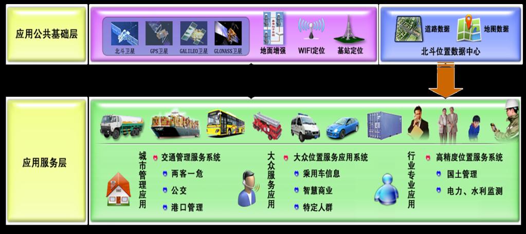
7 System Architecture Space Segment Ground Segment User Segment 5 GEO satellites 3 IGSO satellites 27 MEO satellites Master Control Stations (MCS) Uplink Stations (US) Monitoring Stations (MS) BeiDou terminals Terminals compatible with other satellite navigation systems Four types of services: open, authorized, wide area differential and short message services.
8 System Architecture l Ground & Satellite based l Positioning and navigation services meter/decimeter-level (wide area) centimeter-level (real time, China and its neighboring areas) 175 reference stations (backbone network),1000+ stations (regional density network) l CAT-I services for civil aviation users Dual-frequency multi-system augmentation signals Preliminary Scheme Argumentation & Integrity

 14 operational satellites in orbit (5GEO+5IGSO+4MEO) Global")
9 Current Status l Since formal regional services provision on December , the BeiDou System has maintained continuous and stable operation, and the service performance has met with the specification requirements. Constellation(Now) 14 operational satellites in orbit (5GEO+5IGSO+4MEO) Global constellation(2020) 35 satellites (5GEO+30 Non-GEO)

10 Current Status BDS System Performancei region l Most parts of the Asia-Pacific region: 55 N-55 S, 55 E-180 E B1I Horizontal Positioning Accuracy l Open Service Performance Specification: Position Accuracy: better than 10 m, Velocity Accuracy: better than 0.2 m/ s. Time Accuracy: better than 20 ns. B1I Elevation Positioning Accuracy


11 Current Status l With 14 fresh BeiDou satellites in orbit, there is the largest number of available GNSS satellites in the BeiDou coverage area. l A hybrid, asymmetric constellation consisting of GEOs, IGSOs and MEOs l IGSOs and GEOs could provide better elevation angle. Service performance is more outstanding in the city canyon, multi-level traffic interchange, and tree-sheltered environment Distribution of visible in-orbit BeiDou satellites


12 Current Status l The 1st new-generation satellites satellite successfully launched on March 30, l New signals and inter-satellite link, and other technologies is undergoing in-orbit test as scheduled. l Right now, the new-generation satellite has preliminarily verified the new technology structure and performance specifications, which meet the designed requirements. The first next-generation BeiDou satellite
13 Fundamental Policies Ø Provide open services free of charge for users. Ø Maintain and perfect the system constantly, improve service performance continuously, and offer services with higher quality. Ø Release open service performance specifications on schedule, bring the function of government and market to full play, promote innovation, popularization and internationalization of BeiDou/GNSS applications, and lay foundation for the national strategic emerging industries. Ø Adhere to the concept of development and win-win cooperation, realize compatibility and interoperability between BeiDou and other GNSS, give the system efficiency into full play and increase users benefits.
14 Contents System Overview System Application International Cooperation Recent Plan Summary


15 Fundamental Products l Promote the R&D and industrialization of fundamental navigation products with independent IPR in an all-round way, with the core as BDS/GNSS compatible chips. Ø the sales volume of BDS/GNSS navigation chip/module has surpassed 6 million pieces Ø the sales volume of high-precision surveying boards has surpassed 85, 000 sets, which amounts to 1/3 of the domestic market share Ø the sales volume of navigation antenna is approximately 3 million sets Ø the sales volume of high-precision antenna is approximately 280, 000 pieces, which amounts to 90% of the domestic market share


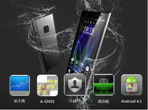
16 Fundamental Products The research and development of next-generation BDS/GNSS chips which integrate baseband with RF has made great breakthroughs, and will meet global users' demands in the mass market, such as smart phones, PAD, wearable equipment, etc. Smart phones PAD Wearable equipment


17 Industrial/Regional Applications In view of the significant orientation and fields which have impact on the national welfare, the people's livelihood, and national security, carry out demonstrative applications in selected industries and regions with relevantly large application scales and outstanding marketing prospects. Harbin 18 Demonstration area Shihezi Beijing Shanxi Xi'an Xinyang Mianyang Hefei Hubei Chengdu Hunan Guizhou Weifang Jiangsu Pearl River Delta Shanghai Yangtze River Delta Zhangzhou Totally 750,000 sets of BeiDou terminals have been promoted and applied. Shenzhen


18 Mass Market Applications


19 Applications Cases Road Transportation Management Cargo, personnel and dangerous goods transportation management Over 80 thousand BeiDou vehicle terminals installed in 9 provinces and cities More than 2 thousand BeiDou/GPS handheld terminals equipped for regional law enforcement


20 Applications Cases Marine Fishery Vessel position monitoring Emergency alarm and rescue Port entry and departure management

21 Applications Cases Maritime Ship Management Integrating BeiDou/GNSS, GIS, satellite communications, mobile communications, etc Tracking & monitoring personnel and cargo logistics Information exchanges services among ships, between ships and the monitoring authority


 Beidou")


22 Applications Cases Disaster Early Warning Air-land-sea integrated disaster surveillance network Collect and transmit real-time information through BeiDou Short message services, mobile/satellite communication Beidou/GNSS Government Buoy Deformation monitoring Communication (DDN/Radio/Mobile) Beidou Receiver Alerts to Meteorological Dept. Weather balloon Meteorological Instruments Monitoring Networks Servers Disaster Early Warning Platform Industry Dept. General Public
 Satellites (Beidou/CAPS/INMARSAT/Thuraya) Communication Disaster")
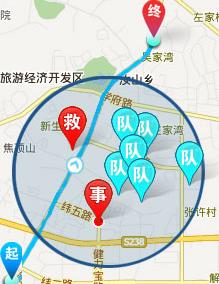
23 Applications Cases Map Emergency Rescue & Command Integrate BeiDou/GNSS, GIS, RS, communication technology Provide positioning and navigation services to rescue staff and vehicles Plan the path for supplies Report information to the commanding center Command Platform, Command Receiver of Beidou, Gateway, Screen (Command Center) Satellites (Beidou/CAPS/INMARSAT/Thuraya) Communication Disaster List MAP Satellites Communication DGNSS Signal Beidou/GPS Position Satellites/ Mobile DGNSS Server Mobile Communication DGNSS Signal Wireless Base Station (GPRS/CDMA2000/WCDMA) Communication Disaster List MAP Picture Disaster Area Disaster Area
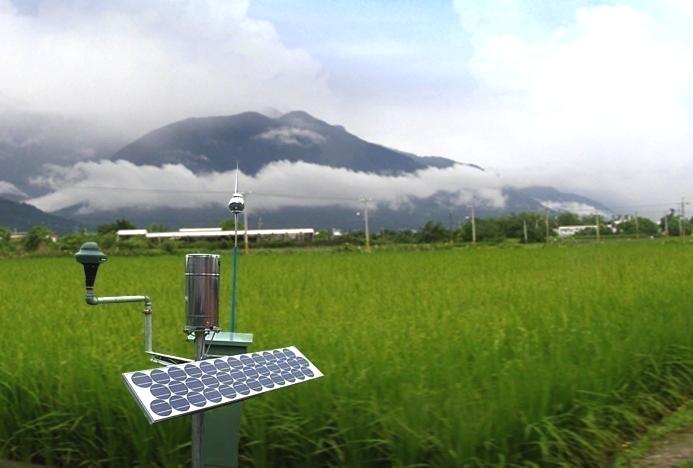


24 Applications Cases Agriculture
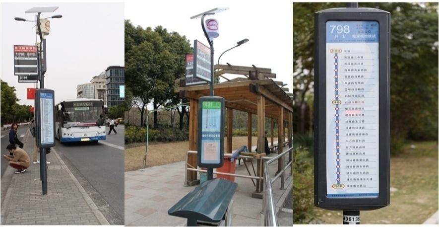
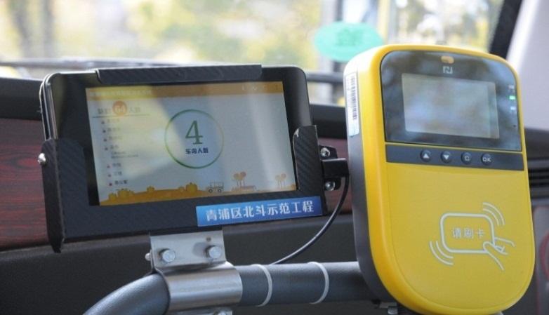
25 Applications Cases City Bus Management
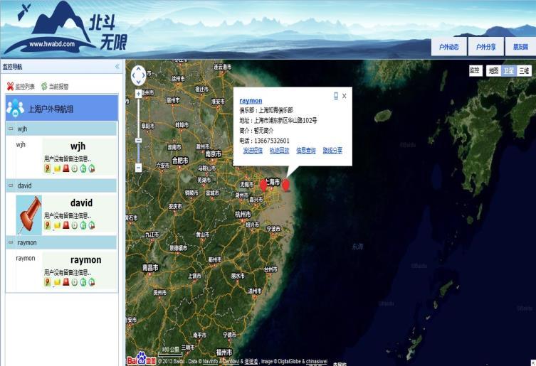


26 Applications Cases Outdoor Tourism
 BeiDou Signal-In-Space Interface Control Document (version 2.")
27 Published Document Related technical documents BeiDou Open Service Performance Standard (version 1.0) BeiDou Signal-In-Space Interface Control Document (version 2.0) Two civil signals of BeiDou- B1I &B2I (Both Chinese and English versions of above documents are available at
28 Contents System Overview System Application International Cooperation Recent Plan Summary


29 Bilateral Cooperation Keep coordinating with other navigation satellite systems in the sector of compatibility and interoperability, to jointly provide high quality services for users.


30 Bilateral Cooperation l The Project Committee on China-Russia GNSS cooperation l The first bilateral round table meeting on GNSS cooperation l The MOU on China-Russia cooperation in the field of satellite navigation l GLONASS ground stations in China and BeiDou ground stations in Russia l The joint statement on compatibility and interoperability.of BeiDou and GLONASS

31 Bilateral Cooperation The first bilateral meeting of China- U.S. civil GNSS cooperation has been held, the cooperation mechanism between BeiDou and GPS has been set up, and the Joint Statement between these two systems have been signed.


32 Bilateral Cooperation The frequency coordination towards navigation frequency channel between BeiDou and Galileo has been completed, and the cooperation mechanism between these systems are under discussion.


33 Multilateral Cooperation Actively undertake international responsibility, promote the compatibility and coexistence among navigation satellite systems. Actively participate in the 9th Meeting of the ICG, IWG, ITU and other GNSS activities organized by the United Nations Deeply join in the coordination of important subjects, such as the compatibility and interoperability among basic systems and Satellite-Bases Augmentation Systems, service performance parameter, GNSS monitoring and assessment, etc.


34 Applications Cooperation Advocate integrated applications of multiple systems, push forward the BeiDou services to spread abroad and benefit neighboring countries, and include applying BeiDou System into the national strategic planning of jointly building the Silk Road Economic Belt and 21st- Century Maritime Silk Road, namely "One Belt and One Road". Carry out cooperation with Korea, Australia, Indonesia, Pakistan, Thailand, Singapore, the United Arab States, Nigeria, etc. Continue to hold BeiDou ASEAN Tour and BeiDou Asia-Pacific Tour, and promote system applications. Satellite navigation cooperation meeting between China-Australia Visit Egypt for on-site survey in 2015 BeiDou ASEAN Tour Thailand


35 International Standardization Actively propel the recognition of the BeiDou System in international organizations, such as IMO, ICAO and 3GPP. The Ship-borne BeiDou-based Receivers Performance Standard has been approved by IMO, making the BeiDou System the third navigation satellite system worldwide recognized by IMO.


36 International Standardization Promote the establishment of BeiDou Working Group affiliated to the 104th professional committee of RTCM. 16 technical standards which support positioning function of the BeiDou System have been approved by the 3rd and 4th Generation Partnership Projects.


37 Technical Exchanges Encourage academic exchanges, host the China Satellite Navigation Conference, and keep attending other international academic conferences in the field of satellite navigation. In the aspect of International Exchange and Training, CSNO has organized three sessions of Master Program majored in satellite navigation, while 44 trainees from 8 countries in the Asia- Pacific and African areas have been recruited. Three sessions of Summer School on Frontier Technology in the field of satellite navigation have successfully organized, and more than 200 trainees have completed their studies.

38 Contents System Overview System Application International Cooperation Recent Plan Summary
39 System Construction 1. Keep improving the continuous stability and service accuracy of the BeiDou System, ensure its regional service performance maintain stable and grow better. 2. Launch another 3-4 next-generation BeiDou satellites in 2015, and steadily accelerate the deployment of next-generation global constellation, to lay foundations for serving the areas along the Silk Road Economic Belt and 21st-Century Maritime Silk Road by Complete the construction of 150 reference stations for the frame network of BeiDou ground based augmentation system, and 300 reference stations for regional density network before the end of 2015, and broadcast the correction data, with meter/decimeter-level positioning accuracy available to major regions nationwide, centimeter level to density regions, and millimeter level correction data for post-processing services. The regional density network will be established within the whole country before the end of 2018.
40 Application Promotion 1. Carry out all-round R&D and industrialization of new generation BDS/GNSS fundamental products, to promote mass market applications amount to tenmillion units. 2. Bring GNSS to full play in the integration procedure between industrialization and IT applications, push forward all-scale industrial and regional demonstrative applications. 3. Comprehensively implement industrial policies and action plans on products quality monitoring, standardization and IPR protection. Improve the industry chain of satellite navigation.
41 International Cooperation 1. Publicize the white paper of the BeiDou System and explain its development concepts, policies and opinions. 2. Perfect the cooperation mechanism among GNSS, deeply participate in the tasks under the ICG, ITU, IMO, ICAO, 3GPP and other international organizations, enhance coordination between BeiDou and GPS, GLONASS, Galileo in the field of compatibility and interoperability. 3. Grasp the opportunity of jointly building the One Belt and One Road national strategy, promote the international applications of BeiDou/ GNSS.
42 Contents System Overview System Application International Cooperation Recent Plan Summary
43 Summary The BeiDou System has been providing stable services to the Asia-Pacific area, successfully launched the first next-generation BeiDou satellite to verify new technologies, deploy the BeiDou augmentation system from allround scale, and steadily push forward the construction of BeiDou System. The BeiDou applications market has been preliminarily fostered, expanding from the typical industries to mass market, and the application industry is under fast development. The BeiDou system deeply promotes cooperation among GNSS, and keeps strengthening international exchanges. "BeiDou" becomes one of the Chinese brands.


44 Thanks
China Satellite Navigation Office
 01 03 Development Plan 02 Latest Progress Recent Plan 01 03 Development Plan 02 Development Objectives Basic Principles Development Steps Latest Progress System Components Fundamental Policies Recent Plan
Operation and Development of BeiDou Navigation Satellite System
 Operation and Development of BeiDou Navigation Satellite System Jing Li IAIN 2015, 20 23 October Prague, Czech Republic 2 01 03 Plan and Policy 02 Status and Near-term Goal International Cooperation 3
Update of BeiDou Navigation Satellite System
 Update of BeiDou Navigation Satellite System 01 03 Development Plan 02 Latest Progress Recent Plans 01 03 Development Plan 02 Development Objectives Basic Principles Development Steps Latest Progress System
Development of BeiDou Navigation Satellite System
 The 8 th Meeting of the International Committee on GNSS Development of BeiDou Navigation Satellite System China Satellite Navigation Office Dubai, UAE November, 2013 Contents Contents 1. Objectives and
International Cooperation Research Center, China Satellite Navigation Office
 International Cooperation Research Center, ICG-8, Nov 10, 2013 Dubai Overview BeiDou Navigation Satellite System (hereinafter referred to as BDS") has provide regional service by the end of 2012, which
Jun Shen International Cooperation Center. China Satellite Navigation Office
 Jun Shen (shenjun@beidou.gov.cn) International Cooperation Center Tenth Meeting of the International Committee on Global Navigation Satellite Systems (ICG) November 1-6, 2015 1 Introduction and Background
BeiDou: Bring the World and China to Your Doorstep
 IGS Workshop 2012-ICG Working Group A BeiDou: Bring the World and China to Your Doorstep China Satellite Navigation Office 2012.7.25 Olsztyn, Poland 1 Contents I. Development Schemes II. Performance III.
China Satellite Navigation Office
 MA Changdou Kathmandu, Nepal 12December 2016 01 Policy of Development 02 Latest Progress 03 Recent Plan The whitepaper on BDS has been released in June 2016, to interpret its development concepts and propositions.
Update on BeiDou Navigation Satellite System
 Update on BeiDou Navigation Satellite System 1 BDS Development 2 Near-term Plans BD-2 System FOC services from December, 2012 (5GEO+5IGSO+4MEO) Two on-orbit backup satellites launched in 2016 (1 IGSO+1
Status of COMPASS/BeiDou Development
 Status of COMPASS/BeiDou Development Stanford s 2009 PNT Challenges and Opportunities Symposium October 21-22,2009 Cao Chong China Technical Application Association for GPS Contents 1. Basic Principles
Status of the European EGNOS and Galileo Programmes. Frank Udnaes Galileo policy and Infrastructure group EC DG-TREN. June 2008
 Status of the European EGNOS and Galileo Programmes Frank Udnaes Galileo policy and Infrastructure group EC DG-TREN EUROPEAN COMMISSION z June 2008 Galileo An infrastructure 30 satellite Constellation
ASSEMBLY 37TH SESSION
 International Civil Aviation Organization WORKING PAPER A37-WP/195 1 22/9/10 (Information paper) ASSEMBLY 37TH SESSION TECHNICAL COMMISSION Agenda Item 35: The Global Air Traffic Management (ATM) System
Update of BeiDou System and its Applications
 Update of BeiDou System and its Applications Prof. Dr. WENG Jingnong International School, Beihang University, P. R. China Beidou International Exchange and Training Center Email: wengjn@buaa.edu.cn April
Nigerian Communications Satellite Ltd. (NIGCOMSAT)
") OVERVIEW OF NIGERIAN SATELLITE AUGMENTATION SYSTEM COMMENCING WITH PILOT DEMONSTRATION TO VALIDATE NATIONAL WORK PLAN presented by Dr. Lawal Lasisi Salami, NIGERIAN COMMUNICATIONS SATELLITE LTD UNDER FEDERAL
OVERVIEW OF NIGERIAN SATELLITE AUGMENTATION SYSTEM COMMENCING WITH PILOT DEMONSTRATION TO VALIDATE NATIONAL WORK PLAN presented by Dr. Lawal Lasisi Salami, NIGERIAN COMMUNICATIONS SATELLITE LTD UNDER FEDERAL
Principal Investigator Co-Principal Investigator Co-Principal Investigator Prof. Talat Ahmad Vice-Chancellor Jamia Millia Islamia Delhi
 Subject Paper No and Title Module No and Title Module Tag Geology Remote Sensing and GIS Concepts of Global Navigation Satellite RS & GIS XXXIII Principal Investigator Co-Principal Investigator Co-Principal
General Assembly. United Nations A/AC.105/946
 United Nations A/AC.105/946 General Assembly Distr.: General 16 November 2009 Original: English Committee on the Peaceful Uses of Outer Space Report on the United Nations/Azerbaijan/United States of America/European
International GNSS Monitoring & Assessment Service for OS (igmas) ICG September 2011, Tokyo, Japan
 ICG September 2011, Tokyo, Japan") Presentation on igmas FOR WORKING GROUP A International GNSS Monitoring & Assessment Service for OS (igmas) by Xurong Dong International Cooperation Research Centre, CSNO ICG 6 5 9 September 2011, Tokyo,
Presentation on igmas FOR WORKING GROUP A International GNSS Monitoring & Assessment Service for OS (igmas) by Xurong Dong International Cooperation Research Centre, CSNO ICG 6 5 9 September 2011, Tokyo,
«Current state and prospects of development of commercial application GLONASS/GNSS in the Russian Federation»
 «Current state and prospects of development of commercial application GLONASS/GNSS in the Russian Federation» United Nations SYMPOSIUM TO STRENGTHEN THE PARTNERSHIP WITH INDUSTRY COMMERCIAL APPLICATIONS
High Precision Applications with BeiDou
 High Precision Applications with BeiDou Lei HUANG Unicore Communications, Inc May 14, 2013 Contents 1 2 3 4 Background Overview of BeiDou high precision products Applications of BeiDou high precision products
PRELIMINARY PROGRAMME
 ICG EXPERTS MEETING: GLOBAL NAVIGATION SATELLITE SYSTEMS SERVICES 14-18 December 2015 Vienna International Centre, Vienna, Austria Organized by International Committee on Global Navigation Satellite Systems
GNSS Programme. Overview and Status in Europe
 GNSS Programme Overview and Status in Europe Inaugural Forum Satellite Positioning Research and Application Center 23 April 2007 Tokyo Presented by Thomas Naecke (European Commission) Prepared by Daniel
SATELLITE BASED AUGMENTATION SYSTEM (SBAS) FOR AUSTRALIA
 FOR AUSTRALIA") SATELLITE BASED AUGMENTATION SYSTEM (SBAS) FOR AUSTRALIA AN AIN POSITION PAPER SUBMITTED TO VARIOUS GOVERNMENT DEPARTMENTS BY MR KYM OSLEY AM, CSC, EXEC SECRETARY AIN What are GNSS Augmentation Systems?
SATELLITE BASED AUGMENTATION SYSTEM (SBAS) FOR AUSTRALIA AN AIN POSITION PAPER SUBMITTED TO VARIOUS GOVERNMENT DEPARTMENTS BY MR KYM OSLEY AM, CSC, EXEC SECRETARY AIN What are GNSS Augmentation Systems?
ISU Symposium The Public Face of Space Strasbourg, France February A quiet and sustainable success story.
 ISU Symposium The Public Face of Space Strasbourg, France 16 18 February 2010 The International Cospas-Sarsat Programme: A quiet and sustainable success story Dany St-Pierre Cospas-Sarsat Secretariat ISU
GLONASS Status and Modernization
 GLONASS Status and Modernization Ekaterina Oleynik Central Research Institute of Roscosmos Federal Space Agency United Nations/Latvia Workshop on the Applications of Global Navigation Satellite Systems
10 th APEC TRANSPORTATION MINISTERIAL MEETING 7 th October 2017 Port Moresby, Papua New Guinea Ministerial Statement
 10 th APEC TRANSPORTATION MINISTERIAL MEETING 7 th October 2017 Port Moresby, Papua New Guinea Ministerial Statement 1. We, the Ministers responsible for transportation, met in Port Moresby, Papua New
ICG-12 Kyoto Japan WG-B December Dr. Lisa Mazzuca
 ICG-12 Kyoto Japan WG-B December 5 2017 Dr. Lisa Mazzuca MEOSAR: SPACE SEGMENT BDS & Cospas-Sarsat: C-S JC-31 (Oct 2017) China Working Papers BDS 406 MHz MEOSAR REPEATER TECHNOLOGY STATUS (JC31-9/2) Executive
IMO WORLD-WIDE RADIONAVIGATION SYSTEM (WWRNS) GALILEO receiver performance standards. Submitted by the European Commission
 GALILEO receiver performance standards. Submitted by the European Commission") INTERNATIONAL MARITIME ORGANIZATION E IMO SUB-COMMITTEE ON SAFETY OF NAVIGATION 50th session Agenda item 13 2 April 2004 Original: ENGLISH WORLD-WIDE RADIONAVIGATION SYSTEM (WWRNS) GALILEO receiver performance
INTERNATIONAL MARITIME ORGANIZATION E IMO SUB-COMMITTEE ON SAFETY OF NAVIGATION 50th session Agenda item 13 2 April 2004 Original: ENGLISH WORLD-WIDE RADIONAVIGATION SYSTEM (WWRNS) GALILEO receiver performance
Understanding GPS/GNSS
 Understanding GPS/GNSS Principles and Applications Third Edition Contents Preface to the Third Edition Third Edition Acknowledgments xix xxi CHAPTER 1 Introduction 1 1.1 Introduction 1 1.2 GNSS Overview
Overview of the global GNSS market and status of Galileo
 2012 GNSS.asia workshop Overview of the global GNSS market and status of Galileo 6 November, 2012 Taipei Justyna Redelkiewicz, European GNSS Agency European GNNS Agency supports European Commission in
GPS/WAAS Program Update
 GPS/WAAS Program Update UN/Argentina Workshop on the Applications of GNSS 19-23 March 2018 Cordoba, Argentina GNSS: A Global Navigation Satellite System of Systems Global Constellations GPS (24+3) GLONASS
GLObal Navigation Satellite System (GLONASS)
") FEDERAL SPACE AGENCY GLObal Navigation Satellite System (GLONASS) Sergey Revnivykh Deputy Director General Central Research Institute of Machine Building Head of PNT Center 4-th meeting of International
FEDERAL SPACE AGENCY GLObal Navigation Satellite System (GLONASS) Sergey Revnivykh Deputy Director General Central Research Institute of Machine Building Head of PNT Center 4-th meeting of International
Current status of Quasi-Zenith Satellite System. Japan Aerospace Exploration Agency QZSS Project Team
 Current status of Quasi-Zenith Satellite System Japan Aerospace Exploration Agency QZSS Project Team 1 Quasi-Zenith Satellite System The QZSS is a regional space-based PNT (Positioning, Navigation and
European GNSS Evolution
 Ref. Ares(204)902599 - /06/204 European GNSS Evolution Hermann Ebner Galileo and EGNOS Programme Management DG Enterprise and Industry Content Introduction 2 2 Major Challenges for EGNSS Evolution 3 EGNSS
European GNSS Applications in H2020
 European GNSS Applications in H2020 Countdown to H2020 12.12.2013, Brussels Carmen Aguilera European GNSS Agency Agenda European GNSS Agency EU-GNSS market potential FP7- experience and results H2020 opportunities
Dimov Stojče Ilčev. CNS Systems
 Stratospheric Platform Systems (SPS) Presentation by: Dimov Stojče Ilčev Durban University of Technology (DUT) Space Science Centre (SSC) CNS Systems August 2011 SPS for Mobile CNS Applications Stratospheric
SDCM present status and future. GLONASS signals development.
 The Eighth Meeting of the International Committee on Global Navigation Satellite Systems, November 9 14, 2013, Dubai SDCM present status and future. GLONASS signals development. Prof. Grigory Stupak, Dr.
CLICK HERE TO KNOW MORE
 CLICK HERE TO KNOW MORE Should GNSS Become a National Critical Infrastructure? Ooi Wei Han, Noordin Ahmad, Shahrizal IM National Space Agency (ANGKASA) Ministry of Science, Technology and Innovation (MOSTI)
DYNAMIC POSITIONING CONFERENCE October 7-8, Sensors II. Redundancy in Dynamic Positioning Systems Based on Satellite Navigation
 Return to Session Directory DYNAMIC POSITIONING CONFERENCE October 7-8, 2008 Sensors II Redundancy in Dynamic Positioning Systems Based on Satellite Navigation Ole Ørpen, Tor Egil Melgård, Arne Norum Fugro
Understanding GPS: Principles and Applications Second Edition
 Understanding GPS: Principles and Applications Second Edition Elliott Kaplan and Christopher Hegarty ISBN 1-58053-894-0 Approx. 680 pages Navtech Part #1024 This thoroughly updated second edition of an
IMO WORLDWIDE RADIONAVIGATION SYSTEM (WWRNS) Study on Communication Techniques for High Accuracy DGPS in the Republic of Korea
 Study on Communication Techniques for High Accuracy DGPS in the Republic of Korea") INTERNATIONAL MARITIME ORGANIZATION E IMO SUB-COMMITTEE ON SAFETY OF NAVIGATION 52nd session Agenda item 12 NAV 52/INF.8 12 May 2006 ENGLISH ONLY WORLDWIDE RADIONAVIGATION SYSTEM (WWRNS) Study on Communication
INTERNATIONAL MARITIME ORGANIZATION E IMO SUB-COMMITTEE ON SAFETY OF NAVIGATION 52nd session Agenda item 12 NAV 52/INF.8 12 May 2006 ENGLISH ONLY WORLDWIDE RADIONAVIGATION SYSTEM (WWRNS) Study on Communication
GAGAN Initiatives Jan 18, 2018
 GAGAN Initiatives Jan 18, 2018 Topics covered 1. Brief profile of GAGAN 2. Features / Accuracy of GAGAN System 3. GAGAN Architecture 4. GAGAN services and Coverage 5. GAGAN utilization in aviation sector
GAGAN-Extension to the Gulf Region. Joint ACAC/ICAO MID Workshop on GNSS 7 th & 8 th November 2017
 GAGAN-Extension to the Gulf Region Joint ACAC/ICAO MID Workshop on GNSS 7 th & 8 th November 2017 P.N.S. KUSHWAHA EXECUTIVE DIRECTOR (CNS P) Airports Authority of India New Delhi Topics covered : 1. GAGAN
King AbdulAziz University. Faculty of Environmental Design. Geomatics Department. Mobile GIS GEOM 427. Lecture 3
 King AbdulAziz University Faculty of Environmental Design Geomatics Department Mobile GIS GEOM 427 Lecture 3 Ahmed Baik, Ph.D. Email: abaik@kau.edu.sa Eng. Fisal Basheeh Email: fbasaheeh@kau.edu.sa GNSS
DEFINING THE FUTURE OF SATELLITE SURVEYING WITH TRIMBLE R-TRACK TECHNOLOGY
 DEFINING THE FUTURE OF SATELLITE SURVEYING WITH TRIMBLE R-TRACK TECHNOLOGY EDMOND NORSE, GNSS PORTFOLIO MANAGER, TRIMBLE SURVEY DIVISION WESTMINSTER, CO USA ABSTRACT In September 2003 Trimble introduced
RESOLUTION MSC.401(95) (Adopted on 8 June 2015) PERFORMANCE STANDARDS FOR MULTI-SYSTEM SHIPBORNE RADIONAVIGATION RECEIVERS
 (Adopted on 8 June 2015) PERFORMANCE STANDARDS FOR MULTI-SYSTEM SHIPBORNE RADIONAVIGATION RECEIVERS") ANNEX 17 MSC 95/22/Add.2 Annex 17, page 1 THE MARITIME SAFETY COMMITTEE, RECALLING Article 28(b) of the Convention on the International Maritime Organization concerning the functions of the Committee,
ANNEX 17 MSC 95/22/Add.2 Annex 17, page 1 THE MARITIME SAFETY COMMITTEE, RECALLING Article 28(b) of the Convention on the International Maritime Organization concerning the functions of the Committee,
Perspective of Eastern Global Satellite Navigation Systems
 POSTER 2015, PRAGUE MAY 14 1 Perspective of Eastern Global Satellite Navigation Systems Jiří SVATOŇ Dept. of Radioengineering, Czech Technical University, Technická 2, 166 27 Praha, Czech Republic svatoji2@fel.cvut.cz
EUROPEAN GNSS ADOPTION OPPORTUNITIES IN TRANSPORT WITH FOCUS ON RAIL
 EUROPEAN GNSS ADOPTION OPPORTUNITIES IN TRANSPORT WITH FOCUS ON RAIL Gian Gherardo Calini European GNSS Agency III Workshop GNSS Technology Advances in a Multi-Constellation Framework 22 January 2016 This
New Funding Opportunities to Support Safety of Navigation: EGNOS and Galileo
 New Funding Opportunities to Support Safety of Navigation: EGNOS and Galileo e-navigation Underway 31 January-2 February 2017 GSA 2016 The European GNSS Agency (GSA) today: Staff: about 145 Nationalities:
COMMUNICATIONS FOR MARITIME SAFETY AND EFFICIENCY. Francis Zachariae, Secretary-General, IALA
 COMMUNICATIONS FOR MARITIME SAFETY AND EFFICIENCY Francis Zachariae, Secretary-General, IALA IALA and its Purpose Non profit, international technical association established in 1957 Two Goals aimed at
Report on GNSS Training
 Report on GNSS Training Course ID: T141-30 Afghanistan, Australia, Austria, Bangladesh, Bhutan, Cambodia, India, Indonesia, Japan, Maldives, Mongolia, Nepal, The Philippines, Sri Lanka, Tajikistan, Thailand,
GNSS in Maritime and Education in Egypt
 GNSS in Maritime and Education in Egypt GNSS IN MARITIME PORTS SHIPS PORTS WATERWAYS GNSS maritime applications will help to improve: navigation. Ship operations. Traffic management. Seaport operations.
System Status and Performance Improvement Prospects
 Communication Геодезия Navigation GLOBAL NAVIGATION SATELLITE SYSTEM (GLONASS): System Status and Performance Improvement Prospects Viktor KOSENKO, First Deputy General Designer First Deputy General Director
Indian GNSS Industry Overview Challenges and future prospects
 Indian GNSS Industry Overview Challenges and future prospects Expert Presentation By Dr. S.V. Kibe Consultant, SATCOM & GNSS, Bangalore, India (Former Programme Director, SATNAV,ISRO HQ) On February 20,2013
One Source for Positioning Success
 novatel.com One Source for Positioning Success RTK, PPP, SBAS OR DGNSS. NOVATEL CORRECT OPTIMIZES ALL CORRECTION SOURCES, PUTTING MORE POWER, FLEXIBILITY AND CONTROL IN YOUR HANDS. NovAtel CORRECT is the
Experiences with Fugro's Real Time GPS/GLONASS Orbit/Clock Decimeter Level Precise Positioning System
 Return to Session Directory DYNAMIC POSITIONING CONFERENCE October 13-14, 2009 Sensors Experiences with Fugro's Real Time GPS/GLONASS Orbit/Clock Decimeter Level Precise Positioning System Ole Ørpen and
Report on the United Nations/Croatia Workshop on the Applications of Global Navigation Satellite Systems
 United Nations General Assembly Distr.: General 3 September 2013 Original: English Committee on the Peaceful Uses of Outer Space Report on the United Nations/Croatia Workshop on the Applications of Global
Overview of Intellectual Property Policy and Law of China in 2017
 CPI s Asia Column Presents: Overview of Intellectual Property Policy and Law of China in 2017 By LIU Chuntian 1 & WANG Jiajia 2 (Renmin University of China) October 2018 As China s economic development
GPS Civil Service Update & U.S. International GNSS Activities
 GPS Civil Service Update & U.S. International GNSS Activities International GNSS (IGNSS) Conference Sydney, Australia Jeffrey Auerbach Office of Space and Advanced Technology U.S. Department of State 06
Lecture-1 CHAPTER 2 INTRODUCTION TO GPS
 Lecture-1 CHAPTER 2 INTRODUCTION TO GPS 2.1 History of GPS GPS is a global navigation satellite system (GNSS). It is the commonly used acronym of NAVSTAR (NAVigation System with Time And Ranging) GPS (Global
International Cospas-Sarsat Programme : From operations to MEOSAR prospects
 International Cospas-Sarsat Programme : From operations to MEOSAR prospects Presented by Jean-Charles CORNILLOU MRCC Corsen director with the help of Michel MARGERY (CNES) & Alex GENICOT (FMCC) UN/USA
Protection Augmentation Toughness and Alternatives of GNSS. Melaha 2016 Concord Al-Salam Hotel Cairo, April 25,2016 Refaat Rashad
 Protection Augmentation Toughness and Alternatives of GNSS Melaha 2016 Concord Al-Salam Hotel Cairo, April 25,2016 Refaat Rashad Road Map of the Presentation 1- How Good are GNSS 2- How Vulnerable are
International Committee on Global Navigation Satellite Systems (ICG)
") International Committee on Global Navigation Satellite Systems (ICG) A forum to discuss global navigation satellite systems to benefit people around the world Sharafat Gadimova United Nations Office for
International Committee on Global Navigation Satellite Systems (ICG) A forum to discuss global navigation satellite systems to benefit people around the world Sharafat Gadimova United Nations Office for
VIIIth European Interparliamentary Space. Mr. Rainer Grohe Executive Director Galileo Joint Undertaking
 The European Institutional Framework for Galileo VIIIth European Interparliamentary Space Conference Mr. Rainer Grohe Executive Director Galileo Joint Undertaking Brussels, 12th June 2006 Galileo Architecture
GMDSS modernisation and e-navigation: spectrum needs
 ETSI Workshop "Future Evolution of Marine Communication", 7-8 November 2017, Sophia Antipolis, France GMDSS modernisation and e-navigation: spectrum needs Karlis Bogens BR Terrestrial Services Department
Technical Specifications Document. for. Satellite-Based Augmentation System (SBAS) Testbed
 Testbed") Technical Specifications Document for Satellite-Based Augmentation System (SBAS) Testbed Revision 3 13 June 2017 Table of Contents Acronym Definitions... 3 1. Introduction... 4 2. SBAS Testbed Realisation...
Technical Specifications Document for Satellite-Based Augmentation System (SBAS) Testbed Revision 3 13 June 2017 Table of Contents Acronym Definitions... 3 1. Introduction... 4 2. SBAS Testbed Realisation...
Introduction to Total Station and GPS
 Introduction to Total Station and GPS Dr. P. NANJUNDASWAMY Professor of Civil Engineering J S S Science and Technology University S J College of Engineering Mysuru 570 006 Introduction History GPS Overview
GLOBAL NAVIGATION SATELLITE SYSTEMS (GNSS) ECE 2526E Tuesday, 24 April 2018
 ECE 2526E Tuesday, 24 April 2018") GLOBAL NAVIGATION SATELLITE SYSTEMS (GNSS) ECE 2526E Tuesday, 24 April 2018 MAJOR GLOBAL NAVIGATION SATELLITE SYSTEMS (GNSS) Global Navigation Satellite System (GNSS) includes: 1. Global Position System
GLOBAL NAVIGATION SATELLITE SYSTEMS (GNSS) ECE 2526E Tuesday, 24 April 2018 MAJOR GLOBAL NAVIGATION SATELLITE SYSTEMS (GNSS) Global Navigation Satellite System (GNSS) includes: 1. Global Position System
The technical contribution of QZSS and GNSS to Tsunami early warning system
 0/17 Tsunami Workshop by Sentinel Asia @Sendai International Center Meeting Room 5 The technical contribution of QZSS and GNSS to Tsunami early warning system July 3, 2012 K. Mutoh, J. Yamashita, and S.
IPSTAR Project. Shin Satellite Public Company Limited 19
 IPSTAR Project This is SATTEL s next satellite project to be launched in 2004 and will cover Asia and Australia. The region is known for its fast-growing telecommunications business. The Company is currently
Comprehensive Study of GNSS Systems
 Quest Journals Journal of Software Engineering and Simulation Volume 3 ~ Issue 2 (2016) pp: 01-06 ISSN(Online) :2321-3795 ISSN (Print):2321-3809 www.questjournals.org Research Paper Comprehensive Study
RESOLUTION MSC.233(82) (adopted on 5 December 2006) ADOPTION OF THE PERFORMANCE STANDARDS FOR SHIPBORNE GALILEO RECEIVER EQUIPMENT
 (adopted on 5 December 2006) ADOPTION OF THE PERFORMANCE STANDARDS FOR SHIPBORNE GALILEO RECEIVER EQUIPMENT") MSC 82/24/Add.2 RESOLUTION MSC.233(82) THE MARITIME SAFETY COMMITTEE, RECALLING Article 28(b) of the Convention on the International Maritime Organization concerning the functions of the Committee, RECALLING
MSC 82/24/Add.2 RESOLUTION MSC.233(82) THE MARITIME SAFETY COMMITTEE, RECALLING Article 28(b) of the Convention on the International Maritime Organization concerning the functions of the Committee, RECALLING
ICG 9 PRAGUE 10 November 2014
 ICG 9 PRAGUE 10 November 2014 GNSS and applications GNSS is technology powerfully enabler of a multitude of applications. Italy, recognizing that, have undertaken initiatives to develop pre-operational
Galileo - European Global Navigation Satellite System
 Abstract Galileo - European Global Navigation Satellite System Wu Chen Department of Land Surveying and Geoinformatics Hong Kong Polytechnic University e-mail: Lswuchen@polyu.du.hk Washington Yotto Ochieng
Prospect for Global Positioning Augmentation Service by QZSS
 Prospect for Global Positioning Augmentation Service by QZSS Global Positioning Augmentation Service Corporation Director, Yoshikatsu Iotake Feb. 6, 2018 Copyright 2018 Global Positioning Augmentation
Developments in Satellite Navigation and Wireless Spectrum
 Developments in Satellite Navigation and Wireless Spectrum Chris Hegarty 14 June 2010 Christopher J. Hegarty, D.Sc. The MITRE Corporation chegarty@mitre.org 781-271-2127 (Tel) The contents of this material
Status of Multi-GNSS Monitoring Network Establishment
 Status of Multi-GNSS Monitoring Network Establishment Japan Aerospace Exploration Agency Satoshi Kogure ICG-6 6 WG-A/D cross-session session @Tokyo, JAPAN 7 September, 2011 Contents Introduction Overview
Report of the Working Group B: Enhancement of Global Navigation Satellite Systems (GNSS) Services Performance
 Services Performance") Report of the Working Group B: Enhancement of Global Navigation Satellite Systems (GNSS) Services Performance 1. The Working Group on Enhancement of Global Navigation Satellite Systems (GNSS) Service Performance
Report of the Working Group B: Enhancement of Global Navigation Satellite Systems (GNSS) Services Performance 1. The Working Group on Enhancement of Global Navigation Satellite Systems (GNSS) Service Performance
Precise Point Positioning with BeiDou
 Precise Point Positioning with BeiDou Ole Ørpen Fugro Satellite Positioning AS Geodesi- og Hydrografidagene Stavanger, 12-13 Nov. 2014 Fugro 2013 Contents The G2 service Galileo Testing 2013 BeiDou Testing
RECOMMENDATION ITU-R M *
 Rec. ITU-R M.823-3 1 RECOMMENDATION ITU-R M.823-3 * Technical characteristics of differential transmissions for global navigation satellite systems from maritime radio beacons in the frequency band 283.5-315
European GNSS: Galileo and EGNOS for next generation Road Charging
 European GNSS: Galileo and EGNOS for next generation Road Charging 20 th October 2014 Gian Gherardo Calini European GNSS Agency (GSA) GNSS have made a huge impact in our society it is key in Road transportation
Challenges and Solutions for GPS Receiver Test
 Challenges and Solutions for GPS Receiver Test Presenter: Mirin Lew January 28, 2010 Agenda GPS technology concepts GPS and GNSS overview Assisted GPS (A-GPS) Basic tests required for GPS receiver verification
The EU Satellite Navigation programmes status Applications for the CAP
 The EU Satellite Navigation programmes status Applications for the CAP Michaël MASTIER European Commission DG ENTR GP3 GNSS Applications, Security and International aspects GPS Workshop 2010 Montpellier
Precise Positioning... what does it mean? Precise GNSS Positioning Not just a niche technology. Chris Rizos 15/12/15
 Precise GNSS Positioning Not just a niche technology Chris Rizos Precise Positioning... what does it mean? 1 Precise Positioning... a spectrum of users... Few mm 1cm 2cm < dm 1dm sub-m Precision agriculture
EGNOS Operations Oper and T and heir T Planned Ev E olution v
 EGNOS Operations a Th P Evo EGNOS Laurent Gauthier, Javier Ventura-Traveset, Felix Toran Navigation Department, ESA Directorate of European Union and Industrial Programmes, Toulouse, France Chantal de
GBAS FOR ATCO. June 2017
 GBAS FOR ATCO June 2017 Disclaimer This presentation is for information purposes only. It should not be relied on as the sole source of information, and should always be used in the context of other authoritative
Where Next for GNSS?
 Where Next for GNSS? Professor Terry Moore Professor of Satellite Navigation Nottingham The University of Nottingham Where Next for GNSS Back to the Future? Professor Terry Moore Professor of Satellite
Building Sustainable and Resilient Communities
 2015/SOM1/EPWG/032 Agenda Item: 8.6 Building Sustainable and Resilient Communities Purpose: Information Submitted by: China 7 th Emergency Preparedness Working Group Meeting Subic, Philippines 28-29 January
International Committee on Global Navigation Satellite Systems (ICG) and its Programme on Global Navigation Satellite Systems (GNSS) Applications
 and its Programme on Global Navigation Satellite Systems (GNSS) Applications") and its Programme on Global Navigation Satellite Systems (GNSS) Applications Sharafat Gadimova ICG Executive Secretariat Office for Outer Space Affairs United Nations Office at Vienna a forum to discuss
and its Programme on Global Navigation Satellite Systems (GNSS) Applications Sharafat Gadimova ICG Executive Secretariat Office for Outer Space Affairs United Nations Office at Vienna a forum to discuss
Update on GNSS Time Creation and Distribution - How well does it really work?
 Update on GNSS Time Creation and Distribution - How well does it really work? ITSF November 1, 2016 Prague Marc A. Weiss, Ph.D. Consultant for National Institute of Standards and Technology marcweissconsulting@gmail.com
Indian Regional Navigation Satellite System (IRNSS) / Navigation with Indian Constellation (NavIC) and GPS Aided Geo Augmented Navigation (GAGAN)
 / Navigation with Indian Constellation (NavIC) and GPS Aided Geo Augmented Navigation (GAGAN)") Indian Regional Navigation Satellite System (IRNSS) / Navigation with Indian Constellation (NavIC) and GPS Aided Geo Augmented Navigation (GAGAN) IRNSS-1A Gsat-8 IRNSS 7 November, 2016 Nilesh M. Desai
Indian Regional Navigation Satellite System (IRNSS) / Navigation with Indian Constellation (NavIC) and GPS Aided Geo Augmented Navigation (GAGAN) IRNSS-1A Gsat-8 IRNSS 7 November, 2016 Nilesh M. Desai
Current Status of the Japanese Quasi-Zenith Satellite System (QZSS)
") Current Status of the Japanese Quasi-Zenith Satellite System (QZSS) 12 November 2008 Koji TERADA QZSS Project Manager Japan Aerospace Exploration Agency Contents Introduction Concept of the QZSS System
Current Status of the Japanese Quasi-Zenith Satellite System (QZSS) 12 November 2008 Koji TERADA QZSS Project Manager Japan Aerospace Exploration Agency Contents Introduction Concept of the QZSS System
GE 113 REMOTE SENSING
 GE 113 REMOTE SENSING Topic 9. Introduction to Global Positioning Systems (GPS) and Other GNSS Technologies Lecturer: Engr. Jojene R. Santillan jrsantillan@carsu.edu.ph Division of Geodetic Engineering
BeiDou Next Generation Signal Design and Expected Performance
 International Technical Symposium on Navigation and Timing ENAC, 17 Nov 2015 BeiDou Next Generation Signal Design and Expected Performance Challenges and Proposed Solutions Zheng Yao Tsinghua University
Global Navigation Satellite Systems (GNSS)Part I EE 570: Location and Navigation
Part I EE 570: Location and Navigation") Lecture Global Navigation Satellite Systems (GNSS)Part I EE 570: Location and Navigation Lecture Notes Update on April 25, 2016 Aly El-Osery and Kevin Wedeward, Electrical Engineering Dept., New Mexico
Lecture Global Navigation Satellite Systems (GNSS)Part I EE 570: Location and Navigation Lecture Notes Update on April 25, 2016 Aly El-Osery and Kevin Wedeward, Electrical Engineering Dept., New Mexico
Remarks by Mr. Sun Chengyong. Head of Delegation. Ministry of Science and Technology, China. May 15-16, 2017
 Remarks by Mr. Sun Chengyong Head of Delegation Ministry of Science and Technology, China the 2 nd Annual Multi-Stakeholder Forum on Science, Technology and Innovation for Sustainable Development May 15-16,
GALILEO Research and Development Activities. Second Call. Area 1A. Statement of Work
 GALILEO Research and Development Activities Second Call Area 1A GNSS Introduction in the Maritime Sector Statement of Work Rue du Luxembourg, 3 B 1000 Brussels Tel +32 2 507 80 00 Fax +32 2 507 80 01 www.galileoju.com
Public Workshop on Optimising the Use of the Radio Spectrum by the Public Sector in the EU. Applications and Technologies
 Public Workshop on Optimising the Use of the Radio Spectrum by the Public Sector in the EU Applications and Technologies John Burns, Aegis Systems Ltd 1st April 2008 0 Scope of Presentation Overview of
GLOBAL POSITIONING SYSTEMS
 GLOBAL POSITIONING SYSTEMS GPS & GIS Fall 2017 Global Positioning Systems GPS is a general term for the navigation system consisting of 24-32 satellites orbiting the Earth, broadcasting data that allows
European Radio Navigation Plan. Gilles LEQUEUX, European Commission Policy Development and Strategies
 European Radio Navigation Plan Gilles LEQUEUX, European Commission Policy Development and Strategies CONTEXT - BENEFITS Space Strategy for Europe Introduction of EGNSS in EU sectoral policies Better strategic
Demonstrator of a Data Processing Centre (DPC) for satellite-based AIS services
 for satellite-based AIS services") Page 1 Demonstrator of a Data Processing Centre (DPC) for satellite-based AIS services 19/20 April 2012 gfabritius@cls.fr Overview of the presentation Page 2 Introducing CLS Introducing AIS / SAT-AIS Scope
Page 1 Demonstrator of a Data Processing Centre (DPC) for satellite-based AIS services 19/20 April 2012 gfabritius@cls.fr Overview of the presentation Page 2 Introducing CLS Introducing AIS / SAT-AIS Scope