International GNSS Monitoring & Assessment Service for OS (igmas) ICG September 2011, Tokyo, Japan
|
|
|
- Jacob Griffin
- 5 years ago
- Views:
Transcription
1 Presentation on igmas FOR WORKING GROUP A International GNSS Monitoring & Assessment Service for OS (igmas) by Xurong Dong International Cooperation Research Centre, CSNO ICG September 2011, Tokyo, Japan
2 Presentation overview 1. Background 2. The Scientific Research Activities on GNSS Performance Monitoring 3. igmas: Objective, Methods and Infrastructure 4. International Cooperation proposals on igmas 5. Concluding remarks
3 1. Background GNSS performance monitoring has become part of the work of ICG Working Group A key issues in the pursuit of better service provision Providers have agreed to consider proposals to widely monitor signals and service performance provide timely updates to users regarding critical performance characteristics e.g. timing, positioning accuracy and service availability[icg/pf/wp/sep2009,item 6,item7] igmas jointly proposed by co-chairs and ICRC of CSNO at the WG- A co-chairs intersessional meeting
4 igmas is complementary to IGS network etc. in terms of SIS quality and constellation status monitoring etc. essential to ensure the interoperability of OS signals able to promote service assurance and improve service performance useful to study on developing international standards of OS
5 In summary, igmas will benefit a lot for not only users to get assured open services with an unified standards. but also Providers to make their own GNSS system sustainable development
6 2. Scientific Research Activities on GNSS Monitoring A lot of scientific research work on GNSS monitoring and assessment have been done worldwide


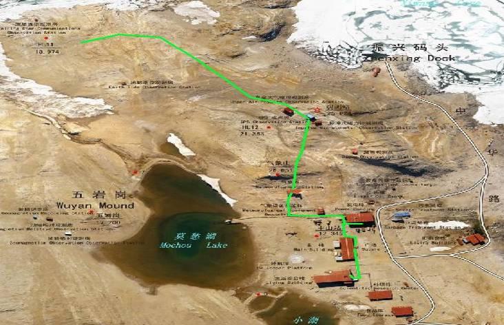
7 2.1 BeiDou Monitoring and Assessment system In China In 2007, a BeiDou tracking network was established: with 6 tracking stations Urumqi Xi an, Changchun Kashi Lasa Lingtong Shanghai Kunming Sanya


8 Antarctic station Swans mountain


9 Analyzing center


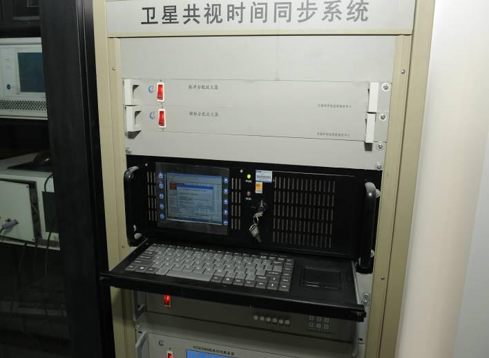
10 . In Feb. 2009, the BeiDou signal quality monitoring system was built by National Time Service Center, Chinese academy of sciences Since April, 2009, this system have performed : signal quality monitoring and assessment for BeiDou GEOs and IGSOs successfully also collecting and analyzing GPS signals and Galileo Glove-B signals 7.3m antenna


11 2.2 Other research activities of GNSS signal monitoring At Stanford Univ.and DLR of Germany At Ohio Univ. Achievements also from other organizations such as a 3-station monitoring network established (with Chibolton observatory intermediate frequency sampling data) to monitor GPS signal anomalies in real time and to provide timely information to the public high-gain antennas to monitor GNSS signals
12 2.3 Multi GNSS Continuous Tracking Network IGS network with about 400 sites worldwide serving GNSS world raw data and products for many years Updating to Multi GNSS currently, M GEX recently proposed MGM net by JAXA designed with 60 sites Benefits of igmas were demonstrated and confirmed by above activities.
13 3. igmas: Tasks, Methods & Infrastructure 3.1 main ideas: to setup a global tracking network to monitor the Multi-GNSS open signal and service performance with not only Multi-GNSS geodetic receivers but also high gain omni-directional antennas, multi-beam antennas to share information to public 3.2 main tasks: to monitor multi-gnss SIS, constellation status, navigation data, and serice performance to contribute to IGS and MGM network by co-location and data sharing To serve GNSS world with data, products, information To evaluate the parameters for interoperability
14 The elements for Monitoring and Assessment of GNSS Constellation status SIS Navigation data Service performance Number Number of of inorbit inorbit satellites satellites Time Time domain domain characteristics characteristics Message Message validity validity Accuracy Accuracy Orbit Orbit distribution distribution Status Status of of each each satellite satellite Constellation Constellation DOP DOP Frequency Frequency domain domain characteristics characteristics Modulation Modulation domain domain characteristics characteristics Correlation Correlation domain domain characteristics characteristics Ionosphere Ionosphere delay delay GNSS GNSS time time bias bias Validity Validity of of Tgd Tgd Availability Availability Integrity Integrity Continuity Continuity


15 3.3 Infrastructure of of igmas Communication satellite GPS GLONASS BeiDou GALILEO Satellite communication Internet Ground tracking network Data Center Satellite communication Internet Analyzing Center Users
16 four main components: The basic functions modules of igmas include: 1)Data monitoring and collecting 2)Data communication 3)Data store 4)Data analyzing and information release
17 3.4 igmas s Complementary aspects to to IGS & MGM networks Common points Complementary igmas IGS network dealing with OS signals tracking Multi GNSS signals based on int. cooperation providing data and product sharing information etc. MGM net Mainly Co location with IGS.MGM stations code + carrier+sis quality+constellation status etc. providing RINEX formatted data to the IGS in support of its multi GNSS project
18 3.4 igmas s Complementary aspects to to IGS & MGM networks igmas IGS MGM net network Data and products sharing with IGS, etc. Precise ephemeris, clocks PM parameter. Station coordinates, velocities Constellation status monitoring Navigation signal power anomalies navigation data monitoring etc
19 4. International Cooperation proposals on igmas 4.1 cooperation issues regarding igmas Recommendations: to set up a technical working group or subgroup to deal with issues of igmas To optimize existing and planed capabilities To identify additional activities,and operational models To deal with the technical things regarding igmas, such as: OS Performance parameters, elements for monitoring, information sharing, jointly setting up stations, etc.
20 4.2 recent activities suggested for the TWG A workshop scheduled during Vienna meeting in Dec. to receive valuable inputs to igmas from Providers to user community, academic organizations and manufacturers etc. to give Providers, industry, and user communities the chance to provide their views on igmas
21 International BeiDou/GNSS demostration Campaign is recommended(initial service in Asia and Pacific region) to test and demonstrate the capabilities of BeiDou/GNSS systems to provide an opportunity to develop potential new GNSS applications enabled by BeiDou/Multi GNSS systems. order to contribute to the above campaign activities. Other All sites will be required to make available RINEX
22 6. Concluding remarks 1. igmas is beneficial to all sides: for the Providers improving their own system, for users, enterprises, academic organizations etc. 2. igmas is complementary to IGS and MGM net etc. 3. igmas is a long term work, needing international cooperation A TWG or subgroup needed. All sides encouraged to take part in this group
23 Thanks for your attention. Dr. Xurong Dong International cooperation research center, China Satellite Navigation Office tel.: fax ; rongerdx@163.com
24 Mandatory requirements: for igmas station selection tracking stations installed with high-gain antennas should meet 1-overlap coverage to satellites at least; those tracking stations for SIS monitoring should meet 4-overlap coverage to satellites; Intended number of sites : 30 at least, Mainly Co-location with IGS.MGM stations Provision of RINEX formatted data to the IGS in support of its multi-gnss project.
BeiDou: Bring the World and China to Your Doorstep
 IGS Workshop 2012-ICG Working Group A BeiDou: Bring the World and China to Your Doorstep China Satellite Navigation Office 2012.7.25 Olsztyn, Poland 1 Contents I. Development Schemes II. Performance III.
Update of BeiDou Navigation Satellite System
 Update of BeiDou Navigation Satellite System 01 03 Development Plan 02 Latest Progress Recent Plans 01 03 Development Plan 02 Development Objectives Basic Principles Development Steps Latest Progress System
Progress of igmas and
 2017 ICG-12 Progress of igmas and IGMA Joint Trial Project igmas TEAM Kyoto Japan 2th Dec. 2017 Contents 1. Introduction 2. Progress of IGMA Joint Trial Project 3. Reference for Monitoring and Assessment
Multi-GNSS / Multi-Signal code bias determination from raw GNSS observations
 Multi-GNSS / Multi-Signal code bias determination from raw GNSS observations F. Reckeweg, E. Schönemann, T. Springer, M. Becker, W. Enderle Geodätische Woche 2016 InterGEO 11.-13. October 2016 Hamburg,
Status of Multi-GNSS Monitoring Network Establishment
 Status of Multi-GNSS Monitoring Network Establishment Japan Aerospace Exploration Agency Satoshi Kogure ICG-6 6 WG-A/D cross-session session @Tokyo, JAPAN 7 September, 2011 Contents Introduction Overview
Report on a Multi-GNSS Demonstration project in the Asia/Oceania region
 Report on a Multi-GNSS Demonstration project in the Asia/Oceania region - Asia Oceania is the Showcase of New GNSS Era - Japan Aerospace Exploration Agency ICG 5@Turin, Italy October 19, 2010 1 Back Ground
ICG-12 Kyoto Japan WG-B December Dr. Lisa Mazzuca
 ICG-12 Kyoto Japan WG-B December 5 2017 Dr. Lisa Mazzuca MEOSAR: SPACE SEGMENT BDS & Cospas-Sarsat: C-S JC-31 (Oct 2017) China Working Papers BDS 406 MHz MEOSAR REPEATER TECHNOLOGY STATUS (JC31-9/2) Executive
ESA Proposal for Multi GNSS Ensemble Time MGET. Werner Enderle Erik Schoenemann
 ESA Proposal for Multi GNSS Ensemble Time MGET Werner Enderle Erik Schoenemann Overview Introduction - Multi GNSS Ensemble Time (MGET) Impact on User - PVT and POD Impact on System Level Who could provide
International Cooperation Research Center, China Satellite Navigation Office
 International Cooperation Research Center, ICG-8, Nov 10, 2013 Dubai Overview BeiDou Navigation Satellite System (hereinafter referred to as BDS") has provide regional service by the end of 2012, which
Operation and Development of BeiDou Navigation Satellite System
 Operation and Development of BeiDou Navigation Satellite System Jing Li IAIN 2015, 20 23 October Prague, Czech Republic 2 01 03 Plan and Policy 02 Status and Near-term Goal International Cooperation 3
Development of BeiDou Navigation Satellite System
 The 8 th Meeting of the International Committee on GNSS Development of BeiDou Navigation Satellite System China Satellite Navigation Office Dubai, UAE November, 2013 Contents Contents 1. Objectives and
THE CURRENT STATUS OF ASIA OCEANIA MULTI-GNSS DEMONSTRATION CAMPAIGN. Multi-GNSS Asia Secretariat June 4 th, th ICG Providers Forum
 THE CURRENT STATUS OF ASIA OCEANIA MULTI-GNSS DEMONSTRATION CAMPAIGN 1 Multi-GNSS Asia Secretariat June 4 th, 2012 8 th ICG Providers Forum ASIA OCEANIA MULTI-GNSS DEMONSTRATION CAMPAIGN Multi-GNSS Monitoring
International Committee on Global Navigation Satellite Systems (ICG) and its Programme on Global Navigation Satellite Systems (GNSS) Applications
 and its Programme on Global Navigation Satellite Systems (GNSS) Applications") and its Programme on Global Navigation Satellite Systems (GNSS) Applications Sharafat Gadimova ICG Executive Secretariat Office for Outer Space Affairs United Nations Office at Vienna a forum to discuss
and its Programme on Global Navigation Satellite Systems (GNSS) Applications Sharafat Gadimova ICG Executive Secretariat Office for Outer Space Affairs United Nations Office at Vienna a forum to discuss
Status of COMPASS/BeiDou Development
 Status of COMPASS/BeiDou Development Stanford s 2009 PNT Challenges and Opportunities Symposium October 21-22,2009 Cao Chong China Technical Application Association for GPS Contents 1. Basic Principles
Report of the Systems, Signals and Services Working Group (formerly Working Group A)
") ICG/WG-S/NOV2015 Report of the Systems, Signals and Services Working Group (formerly Working Group A) 1. The International Committee on Global Navigation Satellite Systems (ICG) Working Group A (WG-A)
ICG/WG-S/NOV2015 Report of the Systems, Signals and Services Working Group (formerly Working Group A) 1. The International Committee on Global Navigation Satellite Systems (ICG) Working Group A (WG-A)
Report of the Working Group B: Enhancement of Global Navigation Satellite Systems (GNSS) Services Performance
 Services Performance") Report of the Working Group B: Enhancement of Global Navigation Satellite Systems (GNSS) Services Performance 1. The Working Group on Enhancement of Global Navigation Satellite Systems (GNSS) Service Performance
Report of the Working Group B: Enhancement of Global Navigation Satellite Systems (GNSS) Services Performance 1. The Working Group on Enhancement of Global Navigation Satellite Systems (GNSS) Service Performance
Precise Point Positioning with BeiDou
 Precise Point Positioning with BeiDou Ole Ørpen Fugro Satellite Positioning AS Geodesi- og Hydrografidagene Stavanger, 12-13 Nov. 2014 Fugro 2013 Contents The G2 service Galileo Testing 2013 BeiDou Testing
Challenges and Solutions for GPS Receiver Test
 Challenges and Solutions for GPS Receiver Test Presenter: Mirin Lew January 28, 2010 Agenda GPS technology concepts GPS and GNSS overview Assisted GPS (A-GPS) Basic tests required for GPS receiver verification
Eleventh meeting of the International Committee on Global Navigation Satellite Systems
 United Nations A/AC.105/1134 General Assembly Distr.: General 1 December 2016 Original: English Committee on the Peaceful Uses of Outer Space Eleventh meeting of the International Committee on Global Navigation
China Satellite Navigation Office
 01 03 Development Plan 02 Latest Progress Recent Plan 01 03 Development Plan 02 Development Objectives Basic Principles Development Steps Latest Progress System Components Fundamental Policies Recent Plan
Real-Time and Multi-GNSS Key Projects of the International GNSS Service
 Real-Time and Multi-GNSS Key Projects of the International GNSS Service Urs Hugentobler, Chris Rizos, Mark Caissy, Georg Weber, Oliver Montenbruck, Ruth Neilan EUREF 2013 Symposium Budapest, Hungary, May
COMPARISON BETWEEN BROADCAST AND PRECISE ORBITS: GPS GLONASS GALILEO AND BEIDOU. A. Caporali and L. Nicolini University of Padova, Italy
 COMPARISON BETWEEN BROADCAST AND PRECISE ORBITS: GPS GLONASS GALILEO AND BEIDOU A. Caporali and L. Nicolini University of Padova, Italy Summary Previous works Input data and method used Comparison between
PRELIMINARY PROGRAMME
 ICG EXPERTS MEETING: GLOBAL NAVIGATION SATELLITE SYSTEMS SERVICES 14-18 December 2015 Vienna International Centre, Vienna, Austria Organized by International Committee on Global Navigation Satellite Systems
THE CURRENT STATUS OF ASIA OCEANIA MULTI-GNSS DEMONSTRATION CAMPAIGN
 THE CURRENT STATUS OF ASIA OCEANIA MULTI-GNSS DEMONSTRATION CAMPAIGN 1 Multi-GNSS Asia Secretariat July 25, 2012 UN ICG WG-A intersession Mtg. Session4 @UWM Olstzyn, Poland ASIA OCEANIA MULTI-GNSS DEMONSTRATION
Where Next for GNSS?
 Where Next for GNSS? Professor Terry Moore Professor of Satellite Navigation Nottingham The University of Nottingham Where Next for GNSS Back to the Future? Professor Terry Moore Professor of Satellite
Update on BeiDou Navigation Satellite System
 Update on BeiDou Navigation Satellite System 1 BDS Development 2 Near-term Plans BD-2 System FOC services from December, 2012 (5GEO+5IGSO+4MEO) Two on-orbit backup satellites launched in 2016 (1 IGSO+1
Assessment of the Contribution of QZSS Combined GPS/BeiDou Positioning in Asia-Pacific Areas
 Assessment of the Contribution of QZSS Combined GPS/BeiDou Positioning in Asia-Pacific Areas Yize Zhang, Nobuaki Kubo, Junping Chen, Hu Wang and Jiexian Wang Abstract Three QZSS satellites are launched
THE CURRENT STATUS OF ASIA OCEANIA MULTI-GNSS DEMONSTRATION CAMPAIGN
 THE CURRENT STATUS OF ASIA OCEANIA MULTI-GNSS DEMONSTRATION CAMPAIGN 1 7th Meeting of the International Committee on Global Navigation Satellite Systems (ICG) November 5-9, 2012 @Beijing, China ASIA OCEANIA
European GNSS Evolution
 Ref. Ares(204)902599 - /06/204 European GNSS Evolution Hermann Ebner Galileo and EGNOS Programme Management DG Enterprise and Industry Content Introduction 2 2 Major Challenges for EGNSS Evolution 3 EGNSS
International Committee on Global Navigation Satellite Systems
 International Committee on Global Navigation Satellite Systems Training Course on Global Navigation Satellite Systems 14 18 January 2019, Asian Institute of Technology, Bangkok, Thailand Sharafat Gadimova
GNSS: orbits, signals, and methods
 Part I GNSS: orbits, signals, and methods 1 GNSS ground and space segments Global Navigation Satellite Systems (GNSS) at the time of writing comprise four systems, two of which are fully operational and
Posicionamento por ponto com. Posicionamento por satélite UNESP PP 2017 Prof. Galera
 Posicionamento por ponto com multiconstelação GNSS Posicionamento por satélite UNESP PP 2017 Prof. Galera Single-GNSS Observation Equations Considering j = 1; : : : ; f S the frequencies of a certain GNSS
Development of BeiDou Navigation Satellite System
 Development of BeiDou Navigation Satellite System May 18 2015 Krasnoyarsk, Russian Federation Contents 1 2 3 4 5 System Overview System Application International Cooperation Recent Plan Summary Contents
BeiDou Space Service Volume Parameters and its Performance
 BeiDou Space Service Volume Parameters and its Performance Prof. Xingqun ZHAN, Shuai JING Shanghai Jiaotong University, China Xiaoliang WANG China Academy of Space Technology Contents 1 Background and
Preparing for the Future The IGS in a Multi-GNSS World
 Preparing for the Future The IGS in a Multi-GNSS World O. Montenbruck DLR/GSOC 1 The International GNSS Service is a federation of more than 200 institutions and organizations worldwide a Service of the
The International GNSS Service (IGS): Product and Services
: Product and Services") The International GNSS Service (IGS): Product and Services Ruth E. Neilan 1, Chris Rizos 2 1 Director, IGS Central Bureau, NASA/JPL, Pasadena, USA 2 VP IAG, IGS Governing Board, UNSW, Sydney, Australia
The International GNSS Service (IGS): Product and Services Ruth E. Neilan 1, Chris Rizos 2 1 Director, IGS Central Bureau, NASA/JPL, Pasadena, USA 2 VP IAG, IGS Governing Board, UNSW, Sydney, Australia
ICG WG-B Achievements on Interoperable GNSS Space Service Volume (SSV) November, 2016 Sochi, Russian Federation
 November, 2016 Sochi, Russian Federation") ICG WG-B Achievements on Interoperable GNSS Space Service Volume (SSV) November, 2016 Sochi, Russian Federation ICG WG-B Action Group on SSV Action group on SSV was formed within WG-B in order to Establish
ICG WG-B Achievements on Interoperable GNSS Space Service Volume (SSV) November, 2016 Sochi, Russian Federation ICG WG-B Action Group on SSV Action group on SSV was formed within WG-B in order to Establish
Multi-GNSS Environment. Chris Rizos UNSW, Australia President IAG
 Multi-GNSS Environment Chris Rizos UNSW, Australia President IAG Visit official GNSS web sites: GPS - www.navcen.uscg.gov & www.gps.gov GLONASS - glonass-ianc.rsa.ru/en/ Galileo - www.esa.int/our_activities/navigation
Global Positioning Systems Directorate
 Space and Missile Systems Center Global Positioning Systems Directorate GPS Program Update to 8 th Stanford PNT Symposium 30 Oct 2014 Col Matt Smitham Deputy Director, GPS Directorate Global Positioning
Time and frequency transfer methods based on GNSS. LIANG Kun, National Institute of Metrology(NIM), China
, China") Time and frequency transfer methods based on GNSS LIANG Kun, National Institute of Metrology(NIM), China Outline Remote time and frequency transfer GNSS time and frequency transfer methods Data and results
Time and frequency transfer methods based on GNSS LIANG Kun, National Institute of Metrology(NIM), China Outline Remote time and frequency transfer GNSS time and frequency transfer methods Data and results
Fast convergence of Trimble CenterPoint RTX by regional augmentation
 Fast convergence of Trimble CenterPoint RTX by regional augmentation Dr. Ralf Drescher Trimble Terrasat GmbH, Munich EGU General Assembly 2015, Vienna Thursday, 16 April 2015 Outline Introduction CenterPoint
Principal Investigator Co-Principal Investigator Co-Principal Investigator Prof. Talat Ahmad Vice-Chancellor Jamia Millia Islamia Delhi
 Subject Paper No and Title Module No and Title Module Tag Geology Remote Sensing and GIS Concepts of Global Navigation Satellite RS & GIS XXXIII Principal Investigator Co-Principal Investigator Co-Principal
Understanding GPS: Principles and Applications Second Edition
 Understanding GPS: Principles and Applications Second Edition Elliott Kaplan and Christopher Hegarty ISBN 1-58053-894-0 Approx. 680 pages Navtech Part #1024 This thoroughly updated second edition of an
The technical contribution of QZSS and GNSS to Tsunami early warning system
 0/17 Tsunami Workshop by Sentinel Asia @Sendai International Center Meeting Room 5 The technical contribution of QZSS and GNSS to Tsunami early warning system July 3, 2012 K. Mutoh, J. Yamashita, and S.
GNSS MONITORING NETWORKS
 SPACE GNSS MONITORING NETWORKS Satellite communications, earth observation, navigation and positioning and control stations indracompany.com GNSS MONITORING NETWORKS GNSS MONITORING NETWORKS Indra s solutions
GLONASS Status and Modernization
 GLONASS Status and Modernization Ekaterina Oleynik Central Research Institute of Roscosmos Federal Space Agency United Nations/Latvia Workshop on the Applications of Global Navigation Satellite Systems
GFZ Analysis Centre: Multi-GNSS Processing and Products
 GFZ Analysis Centre: Multi-GNSS Processing and Products Mathias Fritsche, Zhiguo Deng, Maik Uhlemann,Thomas Nischan, Markus Bradke, Markus Ramatschi, Andre Brand, Gerda Beeskow DeutschesGeoforschungsZentrum
Trimble GPSNet 2.5 Software for GNSS Infrastructure: New Features. Martin Janousek - Trimble Technical Support - Infrastructure
 Trimble GPSNet 2.5 Software for GNSS Infrastructure: New Features Martin Janousek - Trimble Technical Support - Infrastructure GPSNet Users Seminar Munich, March 30 th /31 th 2006 Overview Support for
GPS/WAAS Program Update
 GPS/WAAS Program Update UN/Argentina Workshop on the Applications of GNSS 19-23 March 2018 Cordoba, Argentina GNSS: A Global Navigation Satellite System of Systems Global Constellations GPS (24+3) GLONASS
High Precision Navigation Capabilities(L1-SAIF) and Applications Using Japanese Quasi-Zenith Satellite System (QZSS)
 and Applications Using Japanese Quasi-Zenith Satellite System (QZSS)") High Precision Navigation Capabilities(L1-SAIF) and Applications Using Japanese Quasi-Zenith Satellite System (QZSS) ICG WG-B Application SG Meeting Munich, Germany March 12, 2012 Satellite Positioning
High Precision Navigation Capabilities(L1-SAIF) and Applications Using Japanese Quasi-Zenith Satellite System (QZSS) ICG WG-B Application SG Meeting Munich, Germany March 12, 2012 Satellite Positioning
PosKEN Related Activities in the Czech Republic
 Research Institute of Geodesy, Topography, and Cartography Geodetic Observatory Pecny Land Survey Office, Prague PosKEN Related Activities in the Czech Republic 2014-2015 National Report J. Šimek 1 and
Precise Common-View Time and Frequency Transfer (PCVTFT) based on BDS GEO Satellite
 based on BDS GEO Satellite") IGS workshop 2016, UNSW, Australia Precise Common-View Time and Frequency Transfer (PCVTFT) based on BDS GEO Satellite Yang Xuhai,Wei Pei,Sun Baoqi,Liu Jihua,Wang Wei National Time Service Center (NTSC),Chinese
IGS workshop 2016, UNSW, Australia Precise Common-View Time and Frequency Transfer (PCVTFT) based on BDS GEO Satellite Yang Xuhai,Wei Pei,Sun Baoqi,Liu Jihua,Wang Wei National Time Service Center (NTSC),Chinese
GLOBAL POSITIONING SYSTEMS
 GLOBAL POSITIONING SYSTEMS GPS & GIS Fall 2017 Global Positioning Systems GPS is a general term for the navigation system consisting of 24-32 satellites orbiting the Earth, broadcasting data that allows
IGS workshop 2018 Multi-GNSS through Global Collaboration Datum: 29 October - 2 November 2018 Plats: Wuhan, China Deltagare: Tong Ning (I0101)
") 2018-11-19 RESERAPPORT IGS workshop 2018 Multi-GNSS through Global Collaboration Datum: 29 October - 2 November 2018 Plats: Wuhan, China Deltagare: Tong Ning (I0101) Syfte med mötet The workshop programme
2018-11-19 RESERAPPORT IGS workshop 2018 Multi-GNSS through Global Collaboration Datum: 29 October - 2 November 2018 Plats: Wuhan, China Deltagare: Tong Ning (I0101) Syfte med mötet The workshop programme
MAGICGNSS RTCM-BASED SERVICE, A LEAP FORWARD TOWARDS MULTI- GNSS HIGH ACCURACY REAL-TIME PROCESSING
 ION GNSS 2015 MAGICGNSS RTCM-BASED SERVICE, A LEAP FORWARD TOWARDS MULTI- GNSS HIGH ACCURACY REAL-TIME PROCESSING SEPTEMBER 16 TH, 2015 - ION GNSS 2015, TAMPA, FLORIDA, USA SESSION E2A: NEXT GENERATION
GPS and GNSS from the International Geosciences Perspective
 GPS and GNSS from the International Geosciences Perspective G. Beutler Astronomical Institute, University of Bern Member of IAG Executive Committee and of IGS Governing Board National Space-Based Positioning,
WHU s developments for the MGEX precise products and the GNSS ultra-rapid products
 IGS Workshop 2016 WHU s developments for the MGEX precise products and the GNSS ultra-rapid products Chuang Shi; Qile Zhao; Min Li; Jing Guo; Jingnan Liu Presented by Jianghui Geng GNSS Research Center,
Terms of Reference for IGMA-IGS Joint Trial Project
 Terms of Reference for IGMA-IGS Joint Trial Project Note: [ ] indicates items request further discussion May11, 2016 IGMA-TF 1. Scope of Trial Project This brief document is aimed at defining the IGMA-IGS
Development of an Open Source Multi GNSS Data Processing Software
 2nd Asia Oceania Regional Workshop on GNSS 2010 Development of an Open Source Multi GNSS Data Processing Software Tomoji TAKASU Tokyo University of Marine Science and Technology Contents Introduction Issues
ProMark 500 White Paper
 ProMark 500 White Paper How Magellan Optimally Uses GLONASS in the ProMark 500 GNSS Receiver How Magellan Optimally Uses GLONASS in the ProMark 500 GNSS Receiver 1. Background GLONASS brings to the GNSS
Broadcasting System Time Scales Offsets in Navigation Messages. Assessment of Feasibility
 Broadcasting System Time Scales Offsets in Navigation Messages. Assessment of Feasibility A. Druzhin, A. Tyulyakov. A. Pokhaznikov Working Group A ICG-8, Dubai, United Arab Emirates 2 Rastrelli Square,
Studies On GNSS Open Service Performance Standard Template
 The 8th Meeting of International Committee on GNSS Studies On GNSS Open Service Performance Standard Template Li Jianwen ZZLJW@126.com Zhengzhou Institute of Surveying and Mapping, China BACKGROUND ICG
BDS Real-time Precise Products from WHU and its application in NBASS
 BDS Real-time Precise Products from WHU and its application in NBASS Shi C., Lou YD., Li M., Gu SF., Zhang WX., Zheng F., Li XJ., Song WW., Dai XL., Yi WT. GNSS Research Center of Wuhan University, GRC
Analysis of GNSS Receiver Biases and Noise using Zero Baseline Techniques
 1 Analysis of GNSS Receiver Biases and Noise using Zero Baseline Techniques Ken MacLeod, Simon Banville, Reza Ghoddousi-Fard and Paul Collins Canadian Geodetic Survey, Natural Resources Canada Plenary
EUPOS: Unified GNSS Augmentation Infrastructure and International Cooperation in Central and Eastern Europe
 EUPOS: Unified GNSS Augmentation Infrastructure and International Cooperation in Central and Eastern Europe Senate Department for Urban Development Geodetic Reference Systems Fehrbelliner Platz 1, 10707
ICG GNSS Interoperability Workshop A Civil Aviation Perspective
 Approved for Public Release; Distribution Unlimited. 13-1907. ICG GNSS Interoperability Workshop A Civil Aviation Perspective C h r i s t o p h e r J. H e g a r t y A p r i l 2 0 1 3 Disclaimer: The contents
Space and Missile Systems Center
 Space and Missile Systems Center Global Positioning Systems Directorate GPS Status & Modernization Progress: Service, Satellites, Control Segment, and Military GPS User Equipment 3 Nov 2016 Col Steve Whitney,
General Assembly. United Nations A/AC.105/946
 United Nations A/AC.105/946 General Assembly Distr.: General 16 November 2009 Original: English Committee on the Peaceful Uses of Outer Space Report on the United Nations/Azerbaijan/United States of America/European
GPS and Recent Alternatives for Localisation. Dr. Thierry Peynot Australian Centre for Field Robotics The University of Sydney
 GPS and Recent Alternatives for Localisation Dr. Thierry Peynot Australian Centre for Field Robotics The University of Sydney Global Positioning System (GPS) All-weather and continuous signal system designed
King AbdulAziz University. Faculty of Environmental Design. Geomatics Department. Mobile GIS GEOM 427. Lecture 3
 King AbdulAziz University Faculty of Environmental Design Geomatics Department Mobile GIS GEOM 427 Lecture 3 Ahmed Baik, Ph.D. Email: abaik@kau.edu.sa Eng. Fisal Basheeh Email: fbasaheeh@kau.edu.sa GNSS
GLObal Navigation Satellite System (GLONASS)
") FEDERAL SPACE AGENCY GLObal Navigation Satellite System (GLONASS) Sergey Revnivykh Deputy Director General Central Research Institute of Machine Building Head of PNT Center 4-th meeting of International
FEDERAL SPACE AGENCY GLObal Navigation Satellite System (GLONASS) Sergey Revnivykh Deputy Director General Central Research Institute of Machine Building Head of PNT Center 4-th meeting of International
International Committee on Global Navigation Satellite Systems (ICG)
") International Committee on Global Navigation Satellite Systems (ICG) A forum to discuss global navigation satellite systems to benefit people around the world Sharafat Gadimova United Nations Office for
International Committee on Global Navigation Satellite Systems (ICG) A forum to discuss global navigation satellite systems to benefit people around the world Sharafat Gadimova United Nations Office for
High Precision Applications with BeiDou
 High Precision Applications with BeiDou Lei HUANG Unicore Communications, Inc May 14, 2013 Contents 1 2 3 4 Background Overview of BeiDou high precision products Applications of BeiDou high precision products
Satellite Bias Corrections in Geodetic GPS Receivers
 Satellite Bias Corrections in Geodetic GPS Receivers Demetrios Matsakis, The U.S. Naval Observatory (USNO) Stephen Mitchell, The U.S. Naval Observatory Edward Powers, The U.S. Naval Observatory BIOGRAPHY
The International Scene: How Precise Positioning Will Underpin Critical GNSS Applications
 The International Scene: How Precise Positioning Will Underpin Critical GNSS Applications School of Civil & Environmental Engineering, UNSW, Sydney, Australia Chris Rizos Member of the IGS Governing Board
PageNET: In Support of the Surveying Community
 Philippine Active Geodetic Network : In Support of the Surveying Community ICG Experts Meeting: Global Navigation Satellite Systems Services Vienna International Center, Vienna, Austria December 14-18,
The Promise and Challenges of Accurate Low Latency GNSS for Environmental Monitoring and Response
 Technical Seminar Reference Frame in Practice, The Promise and Challenges of Accurate Low Latency GNSS for Environmental Monitoring and Response John LaBrecque Geohazards Focus Area Global Geodetic Observing
ESOC s Multi-GNSS Processing
 ESOC s Multi-GNSS Processing Cristina Garcia-Serrano, Tim Springer, Florian Dilssner, Claudia Flohrer, Erik Schönemann, Werner Enderle ESOC - Navigation Support Office, Darmstadt, Germany IGS Workshop
Recommendation 16-A for Committee Decision
 Recommendation 16-A for Committee Decision Information on the works related to the proposed redefinition of UTC (revision of Recommendation 16 (2012) Considering that: the navigation systems have unique
Status Report on BeiDou International Exchange and Training Center
 Status Report on BeiDou International Exchange and Training Center Associate Prof. Dr. JIN Tian Expert, BeiDou International Exchange and Training Center The UN Regional Centre (RCSSTEAP) in China Deputy
GPS Civil Service Update & U.S. International GNSS Activities
 GPS Civil Service Update & U.S. International GNSS Activities International GNSS (IGNSS) Conference Sydney, Australia Jeffrey Auerbach Office of Space and Advanced Technology U.S. Department of State 06
SSR & RTCM Current Status
 SSR & RTCM Current Status Gerhard Wübbena, Martin Schmitz, Jannes Wübbena Geo++ GmbH 30827 Garbsen, Germany www.geopp.de Outline RTCM SC104 WG s SSR Today SSR Formats SC104 RTCM-SSR Geo++ RTCM 4090 SSR
Global and Regional Real-Time Infrastructure for open access use
 Global and Regional Real-Time Infrastructure for open access use Axel Rülke Federal Agency for Cartography and Geodesy Branch Office Leipzig, Germany Tutorial on (Open) Real-Time Infrastructure and Applications
Understanding GPS/GNSS
 Understanding GPS/GNSS Principles and Applications Third Edition Contents Preface to the Third Edition Third Edition Acknowledgments xix xxi CHAPTER 1 Introduction 1 1.1 Introduction 1 1.2 GNSS Overview
Prospect for Global Positioning Augmentation Service by QZSS
 Prospect for Global Positioning Augmentation Service by QZSS Global Positioning Augmentation Service Corporation Director, Yoshikatsu Iotake Feb. 6, 2018 Copyright 2018 Global Positioning Augmentation
Current status of Quasi-Zenith Satellite System. Japan Aerospace Exploration Agency QZSS Project Team
 Current status of Quasi-Zenith Satellite System Japan Aerospace Exploration Agency QZSS Project Team 1 Quasi-Zenith Satellite System The QZSS is a regional space-based PNT (Positioning, Navigation and
GNSS Programme. Overview and Status in Europe
 GNSS Programme Overview and Status in Europe Inaugural Forum Satellite Positioning Research and Application Center 23 April 2007 Tokyo Presented by Thomas Naecke (European Commission) Prepared by Daniel
Thirteenth meeting of the International Committee on Global Navigation Satellite Systems
 United Nations General Assembly Distr.: General 30 November 2018 Original: English Committee on the Peaceful Uses of Outer Space Thirteenth meeting of the International Committee on Global Navigation Satellite
The Current Status of QZSS Program
 The Current Status of QZSS Program Satoshi Kogure Japan Aerospace Exploration Agency (JAXA) October 21, 2015 International Association of Institute of Navigation World Cogress 2015 @Prague, Czech Republic
PRECISE RECEIVER CLOCK OFFSET ESTIMATIONS ACCORDING TO EACH GLOBAL NAVIGATION SATELLITE SYSTEMS (GNSS) TIMESCALES
 TIMESCALES") ARTIFICIAL SATELLITES, Vol. 52, No. 4 DOI: 10.1515/arsa-2017-0009 PRECISE RECEIVER CLOCK OFFSET ESTIMATIONS ACCORDING TO EACH GLOBAL NAVIGATION SATELLITE SYSTEMS (GNSS) TIMESCALES Thayathip Thongtan National
ARTIFICIAL SATELLITES, Vol. 52, No. 4 DOI: 10.1515/arsa-2017-0009 PRECISE RECEIVER CLOCK OFFSET ESTIMATIONS ACCORDING TO EACH GLOBAL NAVIGATION SATELLITE SYSTEMS (GNSS) TIMESCALES Thayathip Thongtan National
The topic we are going to see in this unit, the global positioning system, is not directly related with the computer networks we use everyday, but it
 The topic we are going to see in this unit, the global positioning system, is not directly related with the computer networks we use everyday, but it is indeed a kind of computer network, as the specialised
Towards a EUREF Service Providing Real-time GNSS Clock and Orbit Corrections
 Towards a EUREF Service Providing Real-time GNSS Clock and Orbit Corrections G. Weber 1), W. Söhne 1), A. Stürze 1), L. Mervart 2) 1) Federal Agency for Cartography and Geodesy, Frankfurt am Main, Germany
GNSS Integrity Monitoring
 www.dlr.de Chart 1 GNSS Integrity Monitoring Martini - Rome, 22 June 2017 GNSS Integrity Monitoring Dr. Ilaria Martini Institute of Communications and Navigation German Aerospace Center Rome, 22.06.2017
Report on GNSS Training
 Report on GNSS Training Course ID: T141-30 Afghanistan, Australia, Austria, Bangladesh, Bhutan, Cambodia, India, Indonesia, Japan, Maldives, Mongolia, Nepal, The Philippines, Sri Lanka, Tajikistan, Thailand,
Approach to the era of Multi-GNSS (GEONET by GSI : part2)
") Approach to the era of Multi-GNSS (GEONET by GSI : part2) Tetsuro IMAKIIRE (Geospatial Information Authority of Japan) Contents 1. Multi GNSS environment 1.1 Expansion of GNSS 1.2 QZSS 2. Utility of Multi
Approach to the era of Multi-GNSS (GEONET by GSI : part2) Tetsuro IMAKIIRE (Geospatial Information Authority of Japan) Contents 1. Multi GNSS environment 1.1 Expansion of GNSS 1.2 QZSS 2. Utility of Multi
Effect of Quasi Zenith Satellite (QZS) on GPS Positioning
 on GPS Positioning") Effect of Quasi Zenith Satellite (QZS) on GPS ing Tomoji Takasu 1, Takuji Ebinuma 2, and Akio Yasuda 3 Laboratory of Satellite Navigation, Tokyo University of Marine Science and Technology 1 (Tel: +81-5245-7365,
Effect of Quasi Zenith Satellite (QZS) on GPS ing Tomoji Takasu 1, Takuji Ebinuma 2, and Akio Yasuda 3 Laboratory of Satellite Navigation, Tokyo University of Marine Science and Technology 1 (Tel: +81-5245-7365,
Influence of Ground Station Number and its Geographical Distribution on Combined Orbit Determination of Navigation Satellite
 Available online at www.sciencedirect.com Procedia Environmental Sciences 10 (2011 ) 2058 2066 2011 3rd International Conference on Environmental Science and Information Conference Application Title Technology
The Stability Analysis of GNSS Satellite DCB
 The Stability Analysis of GNSS Satellite DCB Shuli Song, Junchen Xue, Zhengbiao Zou ShangHai Astronomical Observatory 216-2-12 Sydeny Outline l Introduction l GPS DCB analysis l GLONASS DCB analysis l
GNSS in Maritime and Education in Egypt
 GNSS in Maritime and Education in Egypt GNSS IN MARITIME PORTS SHIPS PORTS WATERWAYS GNSS maritime applications will help to improve: navigation. Ship operations. Traffic management. Seaport operations.
SSR Technology for Scalable Real-Time GNSS Applications
 SSR Technology for Scalable Real-Time GNSS Applications Gerhard Wübbena, Jannes Wübbena, Temmo Wübbena, Martin Schmitz Geo++ GmbH 30827 Garbsen, Germany www.geopp.de Abstract SSR Technology for scalable