Multi-GNSS Environment. Chris Rizos UNSW, Australia President IAG
|
|
|
- Melissa French
- 6 years ago
- Views:
Transcription
1 Multi-GNSS Environment Chris Rizos UNSW, Australia President IAG

2 Visit official GNSS web sites: GPS - & GLONASS - glonass-ianc.rsa.ru/en/ Galileo - BeiDou en.beidou.gov.cn QZSS - ICG -
3 Outline Status of Multi-GNSS Multi-GNSS & the ICG Multi-GNSS & PPP/DGNSS The International GNSS Service
4 Status of Multi-GNSS


5 + Multi-Constellation GNSS Global Constellations: GPS (32)(32) GLONASS (30?)(24) Galileo (30)(4) BeiDou (35)(14) Regional Constellations: QZSS (3-5+)(1) IRNSS (7)(?) SBAS: WAAS (3) MSAS (2) EGNOS (3) GAGAN (2) SDCM (2)


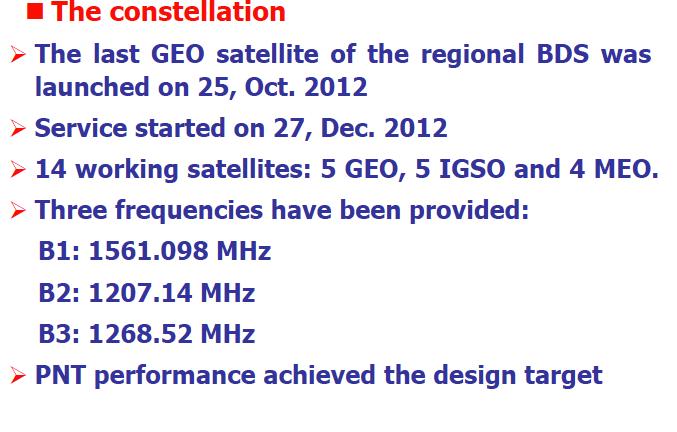
6 GPS Modernization Block IIA/IIR, 1990 from Dec /12 sats from May sats sats 2014
7 GNSS Frequency Bands & Interoperability GPS SBAS M C/A L1C ( P(Y C/A ( P(Y SBAS M L MHz GLONASS Future signal L MHz FDMA signals CDMA signals L MHz Future signal GALILEO MHz MHz E5a MHz E5b MHz E MHz L MHz BeiDou B MHz B MHz B MHz IRNSS QZSS (Japan) QZSS (Japan) L MHz L MHz LEX MHz L MHz IRNSS In S-band

8 Future GNSS Visibility 148 sat constellation Hot Spot
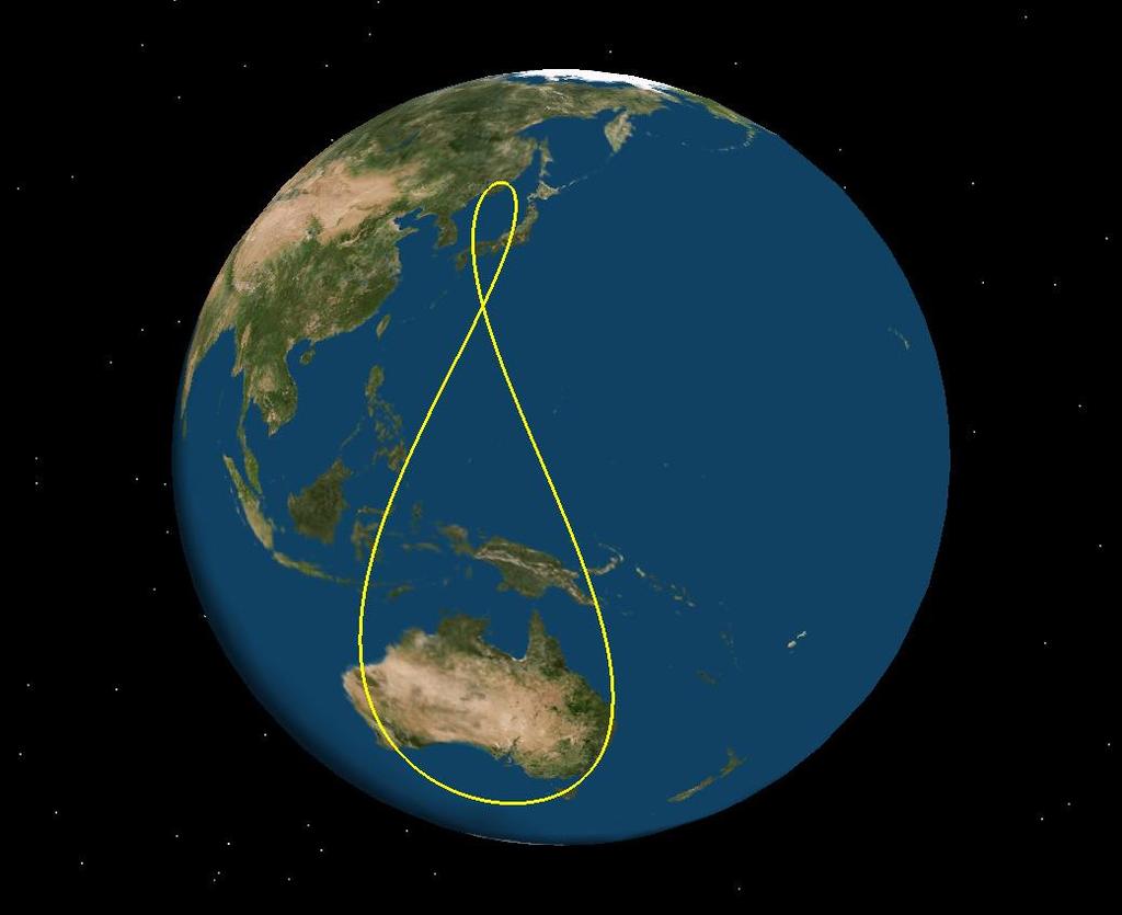
9 BeiDou Mixed Constellation: MEO, IGSO, GEO QZSS IGSO
10
11
12
13 Multi-GNSS and the ICG
14
15 International Committee on GNSS (ICG) A forum to discuss Global Navigation Satellite Systems to benefit people around the world. 2005: Establishment of ICG ICG Membership: Members, Associate Members and Observers 9 nations & the European Union 20 organisations (UN system entities, IGOs, NGOs) IAG & FIG: founding members ICG participation is open to all countries and entities that are either GNSS providers or users of GNSS services, and are interested and willing to actively engage in ICG activities.
16 International Committee on GNSS (ICG) : ICG Annual Meetings UNOOSA (2006), India (2007), USA (2008), Russia (2009), Italy & EU (2010), Japan (2011) 2007: Establishment of Providers Forum China (BeiDou), India (GAGAN/IRNSS), Japan (QZSS/MSAS), Russia (GLONASS), US (GPS), EU (Galileo/EGNOS) 2012: ICG-7, Beijing, China, 5 9 November 2013: ICG-8, Dubai, United Arab Emirates
 Enhancement of performance of GNSS services (India and ESA) Information")
 ICG Executive Secretariat: UNOOSA ICG website: www.icgsecretariat.")

17 International Committee on GNSS (ICG) ICG Working Groups: Compatibility and Interoperability (USA and Russia) Enhancement of performance of GNSS services (India and ESA) Information dissemination and capacity building (UNOOSA) Reference Frame, Timing and Applications (IAG, IGS, FIG) ICG Executive Secretariat: UNOOSA ICG website: Achievements of providers and users of positioning, navigation, and timing services, under the umbrella of the United Nations, in promoting GNSS over the past 10 years.
18 International Committee on GNSS (ICG) WG-A: Compatibility & Interoperability Definitions of Compatibility & Interoperability GNSS Spectrum Protection and Interference Detection and Mitigation Consensus on Open Service GNSS performance parameters, including definitions and calculation methods International GNSS Monitoring and Assessment (IGMA), what parameters to monitor?
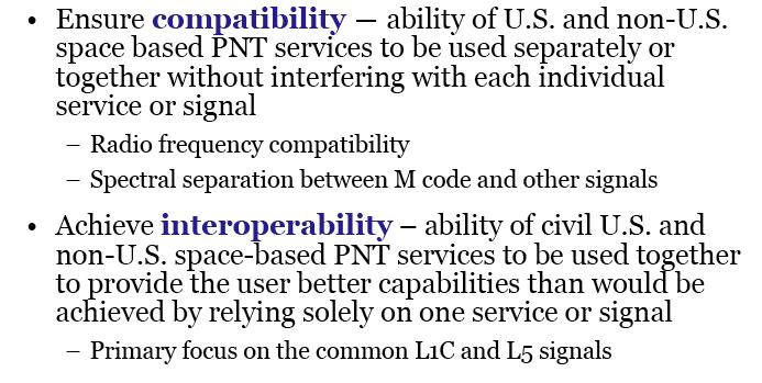
19 Compatibility & Interoperability
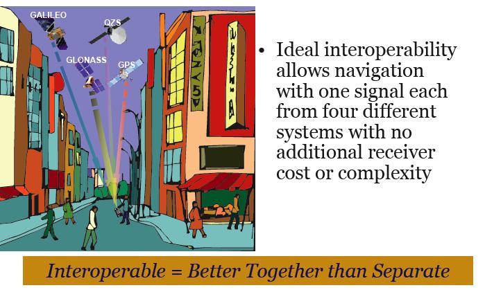
20 Benefits of Interoperability
m, >99% of the Time Actual 2.")
21 GPS Constellation Performance Specification values from the Standard Positioning Service (SPS) Performance Standard (L1-only), September 2008 PDOP (Geometry) Availability Specification - PDOP of 6 or Less, 98% of the time Actual % Horizontal Service Availability Specification - 95% Threshold of 17(36*)m, >99% of the Time Actual 2.74m Vertical Service Availability Specification - 95% Threshold of 37(77*)m, >99% of the Time Actual 3.89m User Range Error (SIS) Specification - 4(6*)m or Less, Constellation Average Actual < 1m System accuracy and availability far exceed 2008 specifications (* 2001 specs)
22 International Committee on GNSS (ICG) WG-B: Enhancement of the Performance on GNSS Services Integrity via ARAIM Satellite Navigation in Natural Disasters Workshop on New Message Broadcasts in New Signals Establishment of a subgroup on GNSS Applications Interoperable GNSS Space Service Volume Standardisation for Maritime Applications
23 International Committee on GNSS (ICG) WG-C: Information Dissemination and Capacity Building Education and Training programmes on GNSS Promoting the use of GNSS technologies as tools for scientific applications Observation of space weather phenomena through the deployment of ground-based instrument arrays such as GPS receivers, magnetometers, solar telescopes, very low frequency (VLF) monitors, solar particle detectors, and data analysis and the sharing of recorded data Regional workshops on applications of GNSS
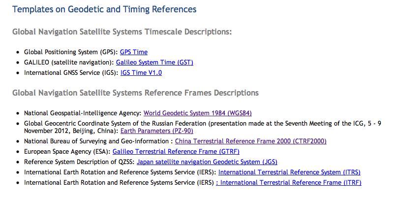
24 International Committee on GNSS (ICG) WG-D: Reference Frames, Timing and Applications Finalization and publication of Templates on Geodetic and Timing References Interoperability of geodetic references among the different GNSS systems IGS M-GEX, as follow up to JAXA s Multi-GNSS Demonstration Campaign in Asia and Oceania
25
26 The WGS84 Reference Frame The general GPS user want coords in the WGS84 datum accessed by SPP solutions using the Navigation Message. In mid-1994 WGS84 was re(de)fined to align it with ITRF91 (at decimetre level) -- WGS84(G730), at the beginning of 1997 WGS84 was again re(de)fined to align it with ITRF94 (sub-decimetre level) -- WGS84(G873), at the beginning of 2002 realigned to ITRF2000 (cm level) -- WGS84(G1150), and in Feb 2012 realigned to ITRF2008 (cm level) WGS(G1674). WGS84 therefore uses ITRF to give it stability. Ref Epoch is (same as ITRF2008). Changes in GPS Ground Segment coords (& therefore users SPP) occur each year, referred to the mid-year epoch not clear what other GNSSs will do.
27 Multi-GNSS and PPP/DGNSS
28 DGNSS techniques have evolved over many years... balancing constraints of accuracy, complexity, timeliness, cost & performance... specialised HW, SW & operations, supported by considerable CORS investment... Hence user GNSS coords expressed in datum defined by fixed coords of CORS

29 CORS Spacing full coverage single-base RTK L1+L2 GPS Rxs Accuracy, Reliability, Availability Good Bad

30 CORS Spacing gaps in coverage single-base RTK L1+L2 GPS Rxs Accuracy, Reliability, Availability Good Bad
31 CORS Spacing full coverage Network-RTK L1+L2 GPS Rxs Accuracy, Reliability, Availability Good Bad
32 CORS Spacing in the future? full coverage N-RTK with dual-freq MGNSS L1+L5 GNSS Rxs Same spacing, but faster AR & better reliability Accuracy, Reliability, Availability Good Bad
33 CORS Spacing in the Future? full coverage single-base RTK with triple-freq MGNSS Multi-GNSS Rxs Accuracy, Reliability, Availability Good Bad
 GNSS Satellite")
 GNSS")


34 PPP: How It Works CORS Network GNSS Constellation(s) GNSS Satellite Orbit and Clock Corrections (Real-time or post-processed) GNSS User Reduction in CORS infrastructure! But currently less efficient & less accurate than DGNSS Coordinate datum now ephemeris datum (not CORES), i.e. IGS08/ITRF2008
35 How will PPP be used? Using DGNSS for T3 surveys to densify or connect to ITRF (e.g. via IGS T1 or national T2 CORS)... But if PPP technique used for T3 surveys, then CORS can be used to monitor stability of national datum... i.e. 4-D coords... In BOTH cases need CORS investment.
36 The International GNSS Service


 International Association for Geodesy/Global Geodetic Observing System (IAG/GGOS) International Earth Rotation and Reference System Service (IERS) Bureau")
37 IGS Associate Members External Interfaces IAG/GGOS IERS BIPM ICSU/WDS UNOOSA/ICG Governing Board Oversight Committees of the GB Executive Committee Strategic Planning Committee Elections Committees Infrastructure Committee Associate Member Committee Pilot Projects and Working Groups Product Coordinators Reference Frame Clock Products Analysis Coordinator Central Bureau Executive Management Network Coordination Information Portal Support Organisations IGS Institute UNAVCO Antenna WG Bias & Calibration WG Clock Product WG Data Centres WG GNSS WG Ionosphere WG Real-time WG & PP Reference Frame WG Space Vehicle Orbit Dynamics WG Troposphere WG Tide Gauge PP Analysis Centres 10 ACs 30 AACs Global Network ACs Global Network AACs Regional Network AACs Other AACs (Ionosphere, Real-Time) Data Centres 4 GDCs 25+ R/ODCs Global Data Centres Regional Data Centres Operational Data Centres Project Data Centres Tracking Stations Reference Frame Stations Multi GNSS Stations Real-time Stations Application Stations (e.g., Tide Gauge) International Association for Geodesy/Global Geodetic Observing System (IAG/GGOS) International Earth Rotation and Reference System Service (IERS) Bureau International des Poids et Mesures (BIPM) International Council for Science/Word Data Systems (ICS/WDS) United Nations Office for Outer Space Affairs/International Committee on GNSS (UNOOSA/ICG) Analysis Centre (AC) Associate Analysis Centre (AAC)
38 Motivation for M-GNSS IGS is the International GNSS Service Well established infrastructure, data and service for GPS (+ GLONASS) IGS Strategic Plan foresees extension to all new GNSSs IGS Strategic Plan includes (multi-gnss) Real-Time Service (RTS) Ongoing deployment of new GNSSs with new signals and satellites BeiDou, Galileo, QZSS, SBAS Continued evolution of products supporting multi-constellation, multi-frequency GNSS Multi-GNSS Experiment (MGEX) Steered by Multi-GNSS Working Group (MGWG) MGEX call-for-participation released in mid-2011 (ongoing) Build-up of new multi-gnss tracking network during 2012 (ongoing) First MGEX results in 2013 Launch of RTS 1 April 2013
39 IGS Working Groups & M-GNSS Working Groups Data Centre WG Reference Frame WG Tide Gauges WG Space Vehicle Orbit Dynamics WG Clock Product WG Troposphere WG Ionosphere WG Antenna WG Bias and Calibration WG MGNSS WG RINEX WG Real Time PP how to convert IGS network to multi-gnss? radiation pressure modelling for new satellites? clock products for new signals? atmospheric remote sensing new systems and signals patterns for new frequencies biases of new signals MGEX observation format (RINEX 3.0) real-time service/ pilot project

40 MGEX Network (April 2013) ~10 contributing agencies >70 stations worldwide Numerous R-T stations (NTRIP, RTCM3-MSM) 6 major receiver types, 7 major antenna types Tracking of Galileo, BeiDou, QZSS Data archives at CDDIS, IGN, BKG RINEX 3.x R-T caster at BKG Free data/product access R/T stations Offline stations ftp://cddis.gsfc.nasa.gov/pub/gps/data/campaign/mgex
 Recommendations, conventions and processing standards: Attitude models Antenna offsets and patterns Data formats: Observations and navigation data (RINEX, RTCM3-MSM)")
41 Standardisation Efforts Continued interactions of MGWG with: GNSS system providers Equipment manufacturers Other IGS Working Groups (esp. R-T WG) Recommendations, conventions and processing standards: Attitude models Antenna offsets and patterns Data formats: Observations and navigation data (RINEX, RTCM3-MSM) Biases (DCBs, intersystem - SINEX?) Orbits
42 IGS MGEX Equipment One to four systems in addition to GPS+GLO GPS+GAL+SBAS GPS+GLO+GAL GPS+GLO+QZSS GPS+GLO+GAL+SBAS GPS+GLO+GAL+BDS GPS+GLO+GAL+BDS+SBAS GPS+GLO+GAL+BDS+QZSS GPS+GLO+GAL+QZSS+SBAS GPS+GLO+GAL+BDS+QZSS+SBAS Receivers IfEN SX_NSR_RT_800 Javad TRE_G3TH Delta Javad TRE_G3T Delta Leica GR10 Leica GR25 Leica GRX1200+GNSS Novatel OEM6 Septentrio PolarX4TR Septentrio PolarXS Trimble NETR8 Trimble NETR9 heterogeneous equipment environment many combinations cross-validation of equipment performance high robustness open to new equipment similar to future user environment Antennas AOAD/M_T JAV_RINGANT_DM JAV_RINGANT_G3T LEIAR10 LEIAR25 LEIAR25.R3 LEIAR25.R4 TPSCR.G3 TRM TRM TRM

43 MGEX Website IGS multi-gnss portal Links to data and products Network status Constellation status Conventions
 ~200 Stations streaming data to IGS")
44 IGS Real-Time Network Larger than any private network, and more redundancy... Will support RT-PPP (& other services) ~200 Stations streaming data to IGS
45 Real-Time Service RTS launched 1 April 2013 Note: IGS01/IGC01 (GPS-only) and IGS02 (GPS-only) streams now fully configured and running on 2 or more servers IGS03 (GPS+GLONASS) experimental stream RTCM3EPH streams Reference is ITRF2008 Stream access via BKG NTRIP Client (BNC) or RTKLIB Register for user access (next slide) Products:

46 Real-Time Service 10 Analysis Centres:
")
47 RTS Product Performance Satellite orbit RMS (compared to IGS Rapid) 1745

48 RTS Product Performance Satellite clock std.dev. (compared to IGS Rapid) 1745

49 RTS IGS02 Products 1745

50 RTS IGS02 Products 1745
51 RTS PPP Results (1) IGS01 Frankfurt a.m.

52 RTS PPP Results (2) IGS02 Frankfurt a.m.

53 RTS PPP Results (3) IGS03 Frankfurt a.m.
54 RTS Who Appears Interested? 80 user registrations within days of launch 142 user registrations by 22 April, from 38 countries
55 IGS Multi-GNSS Plan (tentative) High quality GPS/GLONASS network and products High quality multi-gnss network and products MGEX Build-up and share multi-gnss know-how Build-up network and provide access to multi-gnss data Develop prototype multi-gnss products Develop recommendations and standards Engage with receiver manufacturers and system providers RTS GPS PP Transition Merge legacy and multi- GNSS networks Achieve interoperability of legacy and multi-gnss products and services RTS GPS+ GLONASS Multi-GNSS Pilot Service Incorporate BeiDou, Galileo, and QZSS into standard IGS processing Issue combined and quality controlled multi-gnss IGS orbit, clock and iono products Regular multi-gnss intersystem, interfrequency and intersignal bias estimation Link GNSS system times with IGS system time Embed new GNSSs into IGS/IAG reference frames RTS for multi-gnss
56 Summary Remarks IGS has made important steps towards a multi-gnss service: New global multi-gnss network is being built up First experimental multi-gnss products released Real-Time Service (GPS, GPS+GLONASS) launched Next steps: Engagement with industry, system providers, service providers, manufacturers Network extension for greater Galileo, BeiDou and QZSS coverage Bias and ionosphere products System characterisation (ground and space segment) Recruitment of additional analysis centres Challenges: Resources (three new constellations, new products, improved performance) Lack of tools (in particular: automated quality control) Lack of information from system providers (exception: QZSS)

57 Thank You
Real-Time and Multi-GNSS Key Projects of the International GNSS Service
 Real-Time and Multi-GNSS Key Projects of the International GNSS Service Urs Hugentobler, Chris Rizos, Mark Caissy, Georg Weber, Oliver Montenbruck, Ruth Neilan EUREF 2013 Symposium Budapest, Hungary, May
The International Scene: How Precise Positioning Will Underpin Critical GNSS Applications
 The International Scene: How Precise Positioning Will Underpin Critical GNSS Applications School of Civil & Environmental Engineering, UNSW, Sydney, Australia Chris Rizos Member of the IGS Governing Board
International Committee on Global Navigation Satellite Systems (ICG) and its Programme on Global Navigation Satellite Systems (GNSS) Applications
 and its Programme on Global Navigation Satellite Systems (GNSS) Applications") and its Programme on Global Navigation Satellite Systems (GNSS) Applications Sharafat Gadimova ICG Executive Secretariat Office for Outer Space Affairs United Nations Office at Vienna a forum to discuss
and its Programme on Global Navigation Satellite Systems (GNSS) Applications Sharafat Gadimova ICG Executive Secretariat Office for Outer Space Affairs United Nations Office at Vienna a forum to discuss
Precise Positioning GNSS Applications
 Precise Point Positioning: Is the Era of Differential GNSS Positioning Drawing to an End? School of Surveying & Spatial Information Systems, UNSW, Sydney, Australia Chris Rizos 1, Volker Janssen 2, Craig
Preparing for the Future The IGS in a Multi-GNSS World
 Preparing for the Future The IGS in a Multi-GNSS World O. Montenbruck DLR/GSOC 1 The International GNSS Service is a federation of more than 200 institutions and organizations worldwide a Service of the
The International GNSS Service (IGS): Product and Services
: Product and Services") The International GNSS Service (IGS): Product and Services Ruth E. Neilan 1, Chris Rizos 2 1 Director, IGS Central Bureau, NASA/JPL, Pasadena, USA 2 VP IAG, IGS Governing Board, UNSW, Sydney, Australia
The International GNSS Service (IGS): Product and Services Ruth E. Neilan 1, Chris Rizos 2 1 Director, IGS Central Bureau, NASA/JPL, Pasadena, USA 2 VP IAG, IGS Governing Board, UNSW, Sydney, Australia
INTEROPERABILITY OF THE GNSS'S FOR POSITIONING AND TIMING. A. Caporali, L. Nicolini University of Padova, Italy
 INTEROPERABILITY OF THE GNSS'S FOR POSITIONING AND TIMING A. Caporali, L. Nicolini University of Padova, Italy Outlook Monitor 31 European GNSS sites with 5 different receivers (Javad, Leica, Septentrio,
Report on a Multi-GNSS Demonstration project in the Asia/Oceania region
 Report on a Multi-GNSS Demonstration project in the Asia/Oceania region - Asia Oceania is the Showcase of New GNSS Era - Japan Aerospace Exploration Agency ICG 5@Turin, Italy October 19, 2010 1 Back Ground
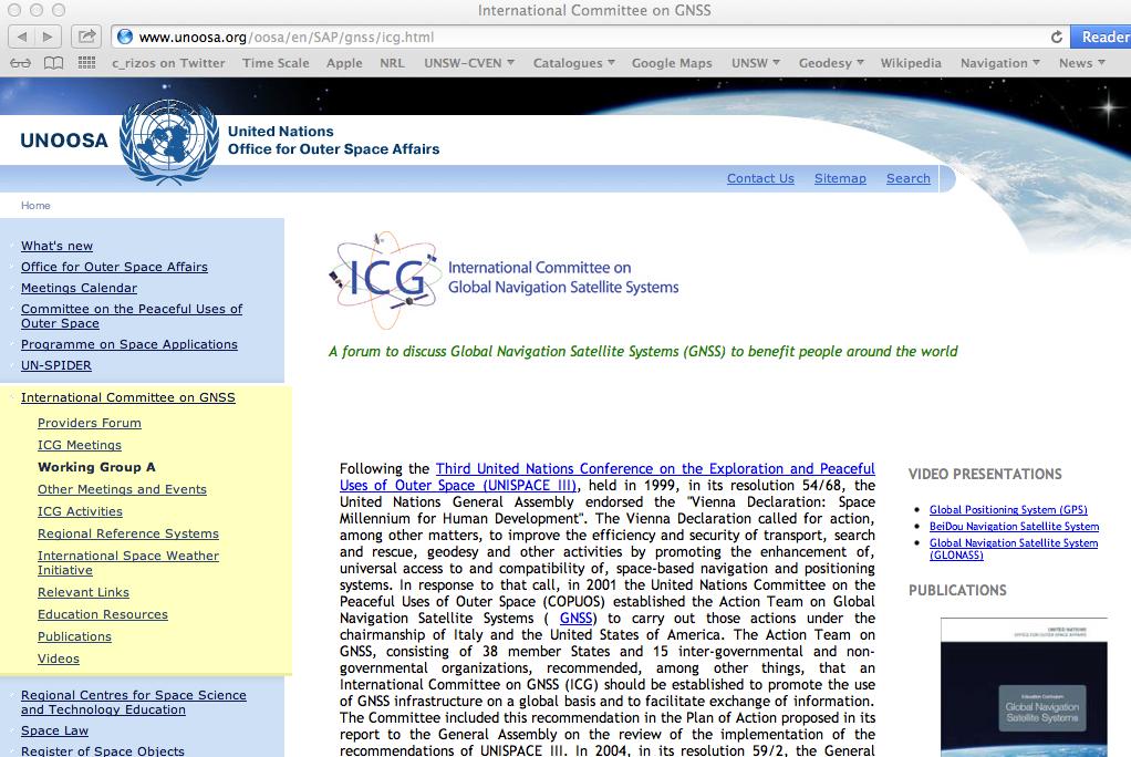
International Committee on Global Navigation Satellite Systems (ICG)
") International Committee on Global Navigation Satellite Systems (ICG) A forum to discuss global navigation satellite systems to benefit people around the world Sharafat Gadimova United Nations Office for
International Committee on Global Navigation Satellite Systems (ICG) A forum to discuss global navigation satellite systems to benefit people around the world Sharafat Gadimova United Nations Office for
Real-time Stream Conversion to RTCM-3 MSM and RINEX-3 in IGS/MGEX Context
 Real-time Stream Conversion to RTCM-3 MSM and RINEX-3 in IGS/MGEX Context Georg Weber (BKG), Ken MacLeod (NRCan), Leos Mervart (CTU), Oliver Montenbruck (DLR), James Perlt (BKG), Dirk Stöcker (Alberding),
International Committee on Global Navigation Satellite Systems and its Programme on the Applications of Global Navigation Satellite Systems
 International Committee on Global Navigation Satellite Systems and its Programme on the Applications of Global Navigation Satellite Systems Sharafat Gadimova United Nations Office for Outer Space Affairs
Development of an Open Source Multi GNSS Data Processing Software
 2nd Asia Oceania Regional Workshop on GNSS 2010 Development of an Open Source Multi GNSS Data Processing Software Tomoji TAKASU Tokyo University of Marine Science and Technology Contents Introduction Issues
GNSS Technology Update
 GNSS Technology Update Speaker: Eric Gakstatter Contributing Editor GPS World Editor - Geospatial Solutions Presented at: Association of Petroleum Surveying & Geomatics Houston, TX April 7, 2015 Agenda
Quasi-Zenith Satellite System (QZSS)
") Transmission of Augmentation Corrections using the Japanese QZSS for Real-Time Precise Point Positioning in Australia Ken Harima 1, Suelynn Choy 1, Mazher Choudhury 2, Chris Rizos 2, Satoshi Kogure 3 1
Transmission of Augmentation Corrections using the Japanese QZSS for Real-Time Precise Point Positioning in Australia Ken Harima 1, Suelynn Choy 1, Mazher Choudhury 2, Chris Rizos 2, Satoshi Kogure 3 1
International Committee on Global Navigation Satellite Systems
 International Committee on Global Navigation Satellite Systems Training Course on Global Navigation Satellite Systems 14 18 January 2019, Asian Institute of Technology, Bangkok, Thailand Sharafat Gadimova
Compact multi-gnss PPP corrections messages for transmission through a 250 bps channel
 Compact multi-gnss PPP corrections messages for transmission through a 250 bps channel Ken Harima, School of Science, RMIT University Suelynn Choy, School of Science, RMIT University Chris Rizos, School
GFZ Analysis Centre: Multi-GNSS Processing and Products
 GFZ Analysis Centre: Multi-GNSS Processing and Products Mathias Fritsche, Zhiguo Deng, Maik Uhlemann,Thomas Nischan, Markus Bradke, Markus Ramatschi, Andre Brand, Gerda Beeskow DeutschesGeoforschungsZentrum
Precise Positioning... what does it mean? Precise GNSS Positioning Not just a niche technology. Chris Rizos 15/12/15
 Precise GNSS Positioning Not just a niche technology Chris Rizos Precise Positioning... what does it mean? 1 Precise Positioning... a spectrum of users... Few mm 1cm 2cm < dm 1dm sub-m Precision agriculture
WHU s developments for the MGEX precise products and the GNSS ultra-rapid products
 IGS Workshop 2016 WHU s developments for the MGEX precise products and the GNSS ultra-rapid products Chuang Shi; Qile Zhao; Min Li; Jing Guo; Jingnan Liu Presented by Jianghui Geng GNSS Research Center,
INTEROPERABILITY OF THE GNSS'S FOR POSITIONING AND TIMING. A. Caporali, L. Nicolini University of Padova, Italy
 INTEROPERABILITY OF THE GNSS'S FOR POSITIONING AND TIMING A. Caporali, L. Nicolini University of Padova, Italy Outlook Monitor 31 European GNSS sites with 5 different receivers (Javad, Leica, Septentrio,
PosKEN Related Activities in the Czech Republic
 Research Institute of Geodesy, Topography, and Cartography Geodetic Observatory Pecny Land Survey Office, Prague PosKEN Related Activities in the Czech Republic 2014-2015 National Report J. Šimek 1 and
Global and Regional Real-Time Infrastructure for open access use
 Global and Regional Real-Time Infrastructure for open access use Axel Rülke Federal Agency for Cartography and Geodesy Branch Office Leipzig, Germany Tutorial on (Open) Real-Time Infrastructure and Applications
One Source for Positioning Success
 novatel.com One Source for Positioning Success RTK, PPP, SBAS OR DGNSS. NOVATEL CORRECT OPTIMIZES ALL CORRECTION SOURCES, PUTTING MORE POWER, FLEXIBILITY AND CONTROL IN YOUR HANDS. NovAtel CORRECT is the
The IGS Real-time Pilot Project
 The IGS Real-time Pilot Project The Development of Real-time IGS Correction Products for Precise Point Positioning Mark Caissy, Georg Weber, Loukis Agrotis, Gerhard Wübbena, and Manuel Hernández-Pajares
Asia Oceania Regional Workshop on GNSS Precise Point Positioning Experiment by using QZSS LEX
 Asia Oceania Regional Workshop on GNSS 2010 Precise Point Positioning Experiment by using QZSS LEX Tomoji TAKASU Tokyo University of Marine Science and Technology Contents Introduction of QZSS LEX Evaluation
MAGICGNSS RTCM-BASED SERVICE, A LEAP FORWARD TOWARDS MULTI- GNSS HIGH ACCURACY REAL-TIME PROCESSING
 ION GNSS 2015 MAGICGNSS RTCM-BASED SERVICE, A LEAP FORWARD TOWARDS MULTI- GNSS HIGH ACCURACY REAL-TIME PROCESSING SEPTEMBER 16 TH, 2015 - ION GNSS 2015, TAMPA, FLORIDA, USA SESSION E2A: NEXT GENERATION
Multi-Constellation GNSS Precise Point Positioning using GPS, GLONASS and BeiDou in Australia
 International Global Navigation Satellite Systems Society IGNSS Symposium 2015 Multi-Constellation GNSS Precise Point Positioning using GPS, GLONASS and BeiDou in Australia Xiaodong Ren 1,Suelynn Choy
Status of Multi-GNSS Monitoring Network Establishment
 Status of Multi-GNSS Monitoring Network Establishment Japan Aerospace Exploration Agency Satoshi Kogure ICG-6 6 WG-A/D cross-session session @Tokyo, JAPAN 7 September, 2011 Contents Introduction Overview
Future GNSS Precision Applications. Stuart Riley
 Future GNSS Precision Applications Stuart Riley Major Trimble Precision Markets Survey Mostly person portable equipment Construction Machine control and person carried equipment Includes Marine applications
GNSS Analysis with Galileo Observations in the Subnetwork of the BEK Analysis Centre
 GNSS Analysis with Galileo Observations in the Subnetwork of the BEK Analysis Centre Christof Völksen Bavarian Academy of Sciences and Humanities (BAdW) Tomasz Liwosz Warsaw University of Technology, Warsaw,
Prospect for Global Positioning Augmentation Service by QZSS
 Prospect for Global Positioning Augmentation Service by QZSS Global Positioning Augmentation Service Corporation Director, Yoshikatsu Iotake Feb. 6, 2018 Copyright 2018 Global Positioning Augmentation
GNSS Accuracy Improvements through Multipath Mitigation with New Signals and services
 GNSS Accuracy Improvements through Multipath Mitigation with New Signals and services Andrey Veytsel, Ph.D Moscow Technical University 10 Meeting of the International Committee on Global Navigation Satellite
QZSS and LEX Signal. Performance of Real-Time Precise Point Positioning Using MADOCA-LEX Augmentation Messages. Outline
 Performance of Real-Time Precise Point Positioning Using MADOCA-LEX Augmentation Messages Suelynn Choy 1, Ken Harima 1, Mohammad Choudhury 2, Yong Li 2, Yaka Wakabayashi 3, Thomas Grinter 4, Satoshi Kogure
BeiDou: Bring the World and China to Your Doorstep
 IGS Workshop 2012-ICG Working Group A BeiDou: Bring the World and China to Your Doorstep China Satellite Navigation Office 2012.7.25 Olsztyn, Poland 1 Contents I. Development Schemes II. Performance III.
Fast convergence of Trimble CenterPoint RTX by regional augmentation
 Fast convergence of Trimble CenterPoint RTX by regional augmentation Dr. Ralf Drescher Trimble Terrasat GmbH, Munich EGU General Assembly 2015, Vienna Thursday, 16 April 2015 Outline Introduction CenterPoint
International GNSS Monitoring & Assessment Service for OS (igmas) ICG September 2011, Tokyo, Japan
 ICG September 2011, Tokyo, Japan") Presentation on igmas FOR WORKING GROUP A International GNSS Monitoring & Assessment Service for OS (igmas) by Xurong Dong International Cooperation Research Centre, CSNO ICG 6 5 9 September 2011, Tokyo,
Presentation on igmas FOR WORKING GROUP A International GNSS Monitoring & Assessment Service for OS (igmas) by Xurong Dong International Cooperation Research Centre, CSNO ICG 6 5 9 September 2011, Tokyo,
GPS/WAAS Program Update
 GPS/WAAS Program Update UN/Argentina Workshop on the Applications of GNSS 19-23 March 2018 Cordoba, Argentina GNSS: A Global Navigation Satellite System of Systems Global Constellations GPS (24+3) GLONASS
Multisystem Real Time Precise-Point-Positioning, today with GPS+GLONASS in the near future also with QZSS, Galileo, Compass, IRNSS
 2 International Symposium on /GNSS October 26-28, 2. Multisystem Real Time Precise-Point-Positioning, today with +GLONASS in the near future also with QZSS, Galileo, Compass, IRNSS Álvaro Mozo García,
King AbdulAziz University. Faculty of Environmental Design. Geomatics Department. Mobile GIS GEOM 427. Lecture 3
 King AbdulAziz University Faculty of Environmental Design Geomatics Department Mobile GIS GEOM 427 Lecture 3 Ahmed Baik, Ph.D. Email: abaik@kau.edu.sa Eng. Fisal Basheeh Email: fbasaheeh@kau.edu.sa GNSS
International Committee on GNSS: The Way Forward to Provide Positioning, Navigation and Timing Globally
 High Level Forum: Space as a Driver for Socio-Economic Sustainable Development, 20 24 November 2016, Dubai, UAE International Committee on GNSS: The Way Forward to Provide Positioning, Navigation and Timing
The added value of new GNSS to monitor the ionosphere
 The added value of new GNSS to monitor the ionosphere R. Warnant 1, C. Deprez 1, L. Van de Vyvere 2 1 University of Liege, Liege, Belgium. 2 M3 System, Wavre, Belgium. Monitoring TEC for geodetic applications
Towards a EUREF Service Providing Real-time GNSS Clock and Orbit Corrections
 Towards a EUREF Service Providing Real-time GNSS Clock and Orbit Corrections G. Weber 1), W. Söhne 1), A. Stürze 1), L. Mervart 2) 1) Federal Agency for Cartography and Geodesy, Frankfurt am Main, Germany
PRELIMINARY PROGRAMME
 ICG EXPERTS MEETING: GLOBAL NAVIGATION SATELLITE SYSTEMS SERVICES 14-18 December 2015 Vienna International Centre, Vienna, Austria Organized by International Committee on Global Navigation Satellite Systems
Multi-GNSS real-time troposphere delay estimation
 Multi-GNSS real-time troposphere delay estimation Jaroslaw Bosy, Tomasz Hadas, Jak Kaplon, Kamil Kazmierski The 7th China Satellite Navigation Conference, May 18-20 Changsha China, Session S1: BDS/GNSS
Where Next for GNSS?
 Where Next for GNSS? Professor Terry Moore Professor of Satellite Navigation Nottingham The University of Nottingham Where Next for GNSS Back to the Future? Professor Terry Moore Professor of Satellite
BeiDou Orbit Determination Processes and Products in JPL's GDGPS System
 BeiDou Orbit Determination Processes and Products in JPL's GDGPS System Ant Sibthorpe, Yoaz Bar-Sever, Willy Bertiger, Wenwen Lu, Robert Meyer, Mark Miller and Larry Romans Outline GNSS (GPS/BDS) with
Assessment of GNSS Ionospheric Scintillation and TEC Monitoring Using the Multi-constellation GPStation-6 Receiver
 Assessment of GNSS Ionospheric Scintillation and TEC Monitoring Using the Multi-constellation GPStation-6 Receiver Rod MacLeod Regional Manager Asia/Pacific NovAtel Australia Pty Ltd Outline Ionospheric
Report of the Working Group B: Enhancement of Global Navigation Satellite Systems (GNSS) Services Performance
 Services Performance") Report of the Working Group B: Enhancement of Global Navigation Satellite Systems (GNSS) Services Performance 1. The Working Group on Enhancement of Global Navigation Satellite Systems (GNSS) Service Performance
Report of the Working Group B: Enhancement of Global Navigation Satellite Systems (GNSS) Services Performance 1. The Working Group on Enhancement of Global Navigation Satellite Systems (GNSS) Service Performance
Analysis of GNSS Receiver Biases and Noise using Zero Baseline Techniques
 1 Analysis of GNSS Receiver Biases and Noise using Zero Baseline Techniques Ken MacLeod, Simon Banville, Reza Ghoddousi-Fard and Paul Collins Canadian Geodetic Survey, Natural Resources Canada Plenary
Time and frequency transfer methods based on GNSS. LIANG Kun, National Institute of Metrology(NIM), China
, China") Time and frequency transfer methods based on GNSS LIANG Kun, National Institute of Metrology(NIM), China Outline Remote time and frequency transfer GNSS time and frequency transfer methods Data and results
Time and frequency transfer methods based on GNSS LIANG Kun, National Institute of Metrology(NIM), China Outline Remote time and frequency transfer GNSS time and frequency transfer methods Data and results
Facility. Development and Testing. What s Next? GNSS Modernization and Next Generation Hardware for the UNAVCO Community
 Facility Development and Testing What s Next? GNSS Modernization and Next Generation Hardware for the UNAVCO Community Frederick Blume UNAVCO Science Workshop, 9 March, 2010 Motivation Last formal hardware
Effect of Quasi Zenith Satellite (QZS) on GPS Positioning
 on GPS Positioning") Effect of Quasi Zenith Satellite (QZS) on GPS ing Tomoji Takasu 1, Takuji Ebinuma 2, and Akio Yasuda 3 Laboratory of Satellite Navigation, Tokyo University of Marine Science and Technology 1 (Tel: +81-5245-7365,
Effect of Quasi Zenith Satellite (QZS) on GPS ing Tomoji Takasu 1, Takuji Ebinuma 2, and Akio Yasuda 3 Laboratory of Satellite Navigation, Tokyo University of Marine Science and Technology 1 (Tel: +81-5245-7365,
International Committee on Global Navigation Satellite Systems (ICG): Building a System of Systems
: Building a System of Systems") International Committee on Global Navigation Satellite Systems (ICG): Building a System of Systems Outline of Presentation Executive Secretariat of the ICG United Nations Office for Outer Space Affairs
International Committee on Global Navigation Satellite Systems (ICG): Building a System of Systems Outline of Presentation Executive Secretariat of the ICG United Nations Office for Outer Space Affairs
NTRIP Background History, Development & BKG. Networked Transport of RTCM via Internet Protocol
 Networked Transport of RTCM via Internet Protocol Networked Transport of RTCM via Internet Protocol Bundesamt für Kartographie und Geodäsie Motivation: Use Internet to transport GNSS corrections Communication
Geoscience & Positioning, Navigation and Timing Services for Canadians
 Geoscience & Positioning, Navigation and Timing Services for Canadians Calvin Klatt, Ph.D. Director and Chief Geodesist Natural Resources Canada / Directeur et géodésien principal Ressources naturelles
The Future of Global Navigation Satellite Systems
 The Future of Global Navigation Satellite Systems Chris RIZOS School of Surveying & Spatial Information Systems University of New South Wales Sydney, NSW 2052, AUSTRALIA E-mail: c.rizos@unsw.edu.au Abstract
Challenges and Solutions for GPS Receiver Test
 Challenges and Solutions for GPS Receiver Test Presenter: Mirin Lew January 28, 2010 Agenda GPS technology concepts GPS and GNSS overview Assisted GPS (A-GPS) Basic tests required for GPS receiver verification
High Precision Navigation Capabilities(L1-SAIF) and Applications Using Japanese Quasi-Zenith Satellite System (QZSS)
 and Applications Using Japanese Quasi-Zenith Satellite System (QZSS)") High Precision Navigation Capabilities(L1-SAIF) and Applications Using Japanese Quasi-Zenith Satellite System (QZSS) ICG WG-B Application SG Meeting Munich, Germany March 12, 2012 Satellite Positioning
High Precision Navigation Capabilities(L1-SAIF) and Applications Using Japanese Quasi-Zenith Satellite System (QZSS) ICG WG-B Application SG Meeting Munich, Germany March 12, 2012 Satellite Positioning
Recommendation 16-A for Committee Decision
 Recommendation 16-A for Committee Decision Information on the works related to the proposed redefinition of UTC (revision of Recommendation 16 (2012) Considering that: the navigation systems have unique
Development of Multi-GNSS Orbit and Clock Determination Software "MADOCA"
 The 5th Asia Oceania Regional Workshop on GNSS Development of Multi-GNSS Orbit and Clock Determination Software "MADOCA" Tokyo Univ. of Marine Science and Technology Tomoji TAKASU December 1-3, 2013 @Hanoi
Alberding solutions for GNSS infrastructure operators
 Tamás Horváth Alberding solutions for GNSS infrastructure operators 21.11.2017 1/35 Alberding solutions for GNSS infrastructure operators Tamás Horváth Alberding GmbH 4 th EUPOS Technical Meeting 21-22
DYNAMIC RT TECHNOLOGY
 DYNAMIC RT TECHNOLOGY GLOBAL NAVIGATION SATELLITE SYSTEMS (GNSS) POTENTIAL FUTURE DEVELOPMENTS(2005 2017?) GPS MODERNIZATION BLOCK IIF & III GLONASS ENHANCEMENTS (K & M) EUROPEAN UNION - GALILEO CHINA
The last 25 years - GPS to multi-gnss: from a military tool to the most widely used civilian positioning solution
 1 The last 25 years - GPS to multi-gnss: from a military tool to the most widely used civilian positioning solution B. Hofmann-Wellenhof Institute of Geodesy / Navigation, Graz University of Technology
GNSS analysis software GSILIB for utilizing Multi- GNSS data
 Technical Seminar Reference Frame in Practice, GNSS analysis software GSILIB for utilizing Multi- GNSS data *Satoshi Kawamoto, Naofumi Takamatsu Geospatial Information Authority of Japan Sponsors: Geospatial
The Global Positioning Sytem II 10/19/2017
 The Global Positioning System II Field Experiments 10/19/2017 5-1 Mexico DGPS Field Campaign Cenotes in Tamaulipas, MX, near Aldama 10/19/2017 5-2 Are Cenote Water Levels Related? 10/19/2017 5-3 M. Helper,
Report of Working Group B: Enhancement of Global Navigation Satellite Systems Services Performance
 Report of : Enhancement of Global Navigation Satellite Systems Services Performance 1. The Working Group on Enhancement of Global Navigation Satellite Systems (GNSS) Service Performance (WG-B) of the International
Satellite-Based Augmentation System (SBAS) Integrity Services
 Integrity Services") Satellite-Based Augmentation System (SBAS) Integrity Services Presented To: Munich, Germany Date: March 8, 2010 By: Leo Eldredge, Manager GNSS Group, FAA FAA Satellite Navigation Program 2 Wide Area Augmentation
Satellite-Based Augmentation System (SBAS) Integrity Services Presented To: Munich, Germany Date: March 8, 2010 By: Leo Eldredge, Manager GNSS Group, FAA FAA Satellite Navigation Program 2 Wide Area Augmentation
The Global Positioning System II Field Experiments
 The Global Positioning System II Field Experiments 5-1 Mexico DGPS Field Campaign Cenotes in Tamaulipas, MX, near Aldama 5-2 Are Cenote Water Levels Related? 5-3 DGPS Static Survey of Cenote Water Levels
Performance Evaluation of Differential Global Navigation Satellite System with RTK Corrections
 IOSR Journal of Electronics and Communication Engineering (IOSR-JECE) e-issn: 2278-2834,p- ISSN: 2278-8735.Volume 9, Issue 2, Ver. VI (Mar - Apr. 2014), PP 43-47 Performance Evaluation of Differential
The technical contribution of QZSS and GNSS to Tsunami early warning system
 0/17 Tsunami Workshop by Sentinel Asia @Sendai International Center Meeting Room 5 The technical contribution of QZSS and GNSS to Tsunami early warning system July 3, 2012 K. Mutoh, J. Yamashita, and S.
Development of BeiDou Navigation Satellite System
 The 8 th Meeting of the International Committee on GNSS Development of BeiDou Navigation Satellite System China Satellite Navigation Office Dubai, UAE November, 2013 Contents Contents 1. Objectives and
Positioning Techniques. João F. Galera Monico - UNESP Tuesday 12 Sep
 Positioning Techniques João F. Galera Monico - UNESP Tuesday 12 Sep Positioning methods Absolute Positioning Static and kinematic SPP and PPP Relative Positioning Static Static rapid Semi kinematic Kinematic
European GNSS Evolution
 Ref. Ares(204)902599 - /06/204 European GNSS Evolution Hermann Ebner Galileo and EGNOS Programme Management DG Enterprise and Industry Content Introduction 2 2 Major Challenges for EGNSS Evolution 3 EGNSS
GPS (GNSS) Telecom Time Now and Future 2011 Telcordia-NIST-ATIS Workshop on Synchronization in Telecommunications Systems May 10-12, 2011
 Telecom Time Now and Future 2011 Telcordia-NIST-ATIS Workshop on Synchronization in Telecommunications Systems May 10-12, 2011") GPS (GNSS) Telecom Time Now and Future 2011 Telcordia-NIST-ATIS Workshop on Synchronization in Telecommunications Systems May 10-12, 2011 Marc A. Weiss, Ph.D. Time and Frequency Division National Institute
GPS (GNSS) Telecom Time Now and Future 2011 Telcordia-NIST-ATIS Workshop on Synchronization in Telecommunications Systems May 10-12, 2011 Marc A. Weiss, Ph.D. Time and Frequency Division National Institute
Eleventh meeting of the International Committee on Global Navigation Satellite Systems
 United Nations A/AC.105/1134 General Assembly Distr.: General 1 December 2016 Original: English Committee on the Peaceful Uses of Outer Space Eleventh meeting of the International Committee on Global Navigation
MGEX Clock Determination at CODE
 source: http://boris.unibe.ch/74079/ downloaded: 13.3.2017 MGEX Clock Determination at CODE E. Orliac, L. Prange, R. Dach, S. Schaer and A. Jäggi Astronomical Institute of University of Bern (AIUB) Bern,
ION GNSS Galileo, an ace up in the sleeve for PPP techniques
 ION GNSS+ 2016 an ace up in the sleeve for PPP techniques September 15 TH, 2016 Session D3: High Precision GNSS Positioning I. Rodríguez-Pérez, L. Martínez-Fernández, G. Tobías-González, J. D. Calle-Calle,
Progress of igmas and
 2017 ICG-12 Progress of igmas and IGMA Joint Trial Project igmas TEAM Kyoto Japan 2th Dec. 2017 Contents 1. Introduction 2. Progress of IGMA Joint Trial Project 3. Reference for Monitoring and Assessment
Introduction to Global Navigation Satellite System (GNSS) Module: 1
 Module: 1") Introduction to Global Navigation Satellite System (GNSS) Module: 1 Dinesh Manandhar Center for Spatial Information Science The University of Tokyo Contact Information: dinesh@iis.u-tokyo.ac.jp Slide :
Introduction to Global Navigation Satellite System (GNSS) Module: 1 Dinesh Manandhar Center for Spatial Information Science The University of Tokyo Contact Information: dinesh@iis.u-tokyo.ac.jp Slide :
Europe s Premier Professional GNSS Receiver Manufacturer
 Europe s Premier Professional GNSS Receiver Manufacturer MundoGEO#Connect LatinAmerica 2013 June 18 to 20 São Paulo (SP) Brazil ir. Peter A. GROGNARD Founder& CEO, Septentrio Septentrio Company Introduction
THE CURRENT STATUS OF ASIA OCEANIA MULTI-GNSS DEMONSTRATION CAMPAIGN. Multi-GNSS Asia Secretariat June 4 th, th ICG Providers Forum
 THE CURRENT STATUS OF ASIA OCEANIA MULTI-GNSS DEMONSTRATION CAMPAIGN 1 Multi-GNSS Asia Secretariat June 4 th, 2012 8 th ICG Providers Forum ASIA OCEANIA MULTI-GNSS DEMONSTRATION CAMPAIGN Multi-GNSS Monitoring
PRECISE RECEIVER CLOCK OFFSET ESTIMATIONS ACCORDING TO EACH GLOBAL NAVIGATION SATELLITE SYSTEMS (GNSS) TIMESCALES
 TIMESCALES") ARTIFICIAL SATELLITES, Vol. 52, No. 4 DOI: 10.1515/arsa-2017-0009 PRECISE RECEIVER CLOCK OFFSET ESTIMATIONS ACCORDING TO EACH GLOBAL NAVIGATION SATELLITE SYSTEMS (GNSS) TIMESCALES Thayathip Thongtan National
ARTIFICIAL SATELLITES, Vol. 52, No. 4 DOI: 10.1515/arsa-2017-0009 PRECISE RECEIVER CLOCK OFFSET ESTIMATIONS ACCORDING TO EACH GLOBAL NAVIGATION SATELLITE SYSTEMS (GNSS) TIMESCALES Thayathip Thongtan National
GNSS Programme. Overview and Status in Europe
 GNSS Programme Overview and Status in Europe Inaugural Forum Satellite Positioning Research and Application Center 23 April 2007 Tokyo Presented by Thomas Naecke (European Commission) Prepared by Daniel
Asian Journal of Science and Technology Vol. 08, Issue, 11, pp , November, 2017 RESEARCH ARTICLE
 Available Online at http://www.journalajst.com ASIAN JOURNAL OF SCIENCE AND TECHNOLOGY ISSN: 0976-3376 Asian Journal of Science and Technology Vol. 08, Issue, 11, pp.6697-6703, November, 2017 ARTICLE INFO
magicgnss: QUALITY DATA, ALGORITHMS AND PRODUCTS FOR THE GNSS USER COMMUNITY
 SEMANA GEOMATICA 2009 magicgnss: QUALITY DATA, ALGORITHMS AND PRODUCTS FOR THE GNSS USER COMMUNITY MARCH 3, 2009 BARCELONA, SPAIN SESSION: GNSS PRODUCTS A. Mozo P. Navarro R. Píriz D. Rodríguez March 3,
Monitoring the EGNOS SYSTEM TEST BED at the Radio Navigation Experimentation Unit (RNEU)
") Monitoring the EGNOS SYSTEM TEST BED at the Radio Navigation Experimentation Unit (RNEU) ESTEC/ESA 2nd ESTB Workshop, Nice, 12th November 2001 What is the RNEU? Specialised facilities located at ESTEC/TOS-ET
Monitoring the EGNOS SYSTEM TEST BED at the Radio Navigation Experimentation Unit (RNEU) ESTEC/ESA 2nd ESTB Workshop, Nice, 12th November 2001 What is the RNEU? Specialised facilities located at ESTEC/TOS-ET
GLONASS Status and Modernization
 GLONASS Status and Modernization Ekaterina Oleynik Central Research Institute of Roscosmos Federal Space Agency United Nations/Latvia Workshop on the Applications of Global Navigation Satellite Systems
SSR Technology for Scalable Real-Time GNSS Applications
 SSR Technology for Scalable Real-Time GNSS Applications Gerhard Wübbena, Jannes Wübbena, Temmo Wübbena, Martin Schmitz Geo++ GmbH 30827 Garbsen, Germany www.geopp.de Abstract SSR Technology for scalable
GNSS 101 Bringing It Down To Earth
 GNSS 101 Bringing It Down To Earth Steve Richter Frontier Precision, Inc. UTM County Coordinates NGVD 29 State Plane Datums Scale Factors Projections Session Agenda GNSS History & Basic Theory Coordinate
NCS TITAN. The most powerful GNSS Simulator available. NCS TITAN Datasheet. Scalability. Extendability. In co-operation with
 NCS TITAN The most powerful GNSS Simulator available Scalability Fidelity Reliability Usability Extendability Flexibility Upgradability Features Signal Capabilities Support of all global (GNSS) and regional
GNSS Training for ITS Developers. 1 - GNSS Principles
 GNSS Training for ITS Developers 1 - GNSS Principles Table of Content Introduction to Satellite Navigation Systems Basics on GNSS Receivers Galileo, the European GNSS EGNOS, the European Augmentation System
SSR & RTCM Current Status
 SSR & RTCM Current Status Gerhard Wübbena, Martin Schmitz, Jannes Wübbena Geo++ GmbH 30827 Garbsen, Germany www.geopp.de Outline RTCM SC104 WG s SSR Today SSR Formats SC104 RTCM-SSR Geo++ RTCM 4090 SSR
GNSS & Coordinate Systems
 GNSS & Coordinate Systems Matthew McAdam, Marcelo Santos University of New Brunswick, Department of Geodesy and Geomatics Engineering, Fredericton, NB May 29, 2012 Santos, 2004 msantos@unb.ca 1 GNSS GNSS
Technical Specifications Document. for. Satellite-Based Augmentation System (SBAS) Testbed
 Testbed") Technical Specifications Document for Satellite-Based Augmentation System (SBAS) Testbed Revision 3 13 June 2017 Table of Contents Acronym Definitions... 3 1. Introduction... 4 2. SBAS Testbed Realisation...
Technical Specifications Document for Satellite-Based Augmentation System (SBAS) Testbed Revision 3 13 June 2017 Table of Contents Acronym Definitions... 3 1. Introduction... 4 2. SBAS Testbed Realisation...
The EU Satellite Navigation programmes status Applications for the CAP
 The EU Satellite Navigation programmes status Applications for the CAP Michaël MASTIER European Commission DG ENTR GP3 GNSS Applications, Security and International aspects GPS Workshop 2010 Montpellier
Lecture-1 CHAPTER 2 INTRODUCTION TO GPS
 Lecture-1 CHAPTER 2 INTRODUCTION TO GPS 2.1 History of GPS GPS is a global navigation satellite system (GNSS). It is the commonly used acronym of NAVSTAR (NAVigation System with Time And Ranging) GPS (Global
General Assembly. United Nations A/AC.105/946
 United Nations A/AC.105/946 General Assembly Distr.: General 16 November 2009 Original: English Committee on the Peaceful Uses of Outer Space Report on the United Nations/Azerbaijan/United States of America/European
Relative positioning with Galileo E5 AltBOC code measurements
 Relative positioning with Galileo E5 AltBOC code measurements Dissertation submitted to the University of Liège in requirements for a Master s degree in Geomatics and Geometrology Cécile Deprez PhD Candidate
Approach to the era of Multi-GNSS (GEONET by GSI : part2)
") Approach to the era of Multi-GNSS (GEONET by GSI : part2) Tetsuro IMAKIIRE (Geospatial Information Authority of Japan) Contents 1. Multi GNSS environment 1.1 Expansion of GNSS 1.2 QZSS 2. Utility of Multi
Approach to the era of Multi-GNSS (GEONET by GSI : part2) Tetsuro IMAKIIRE (Geospatial Information Authority of Japan) Contents 1. Multi GNSS environment 1.1 Expansion of GNSS 1.2 QZSS 2. Utility of Multi
Understanding GPS/GNSS
 Understanding GPS/GNSS Principles and Applications Third Edition Contents Preface to the Third Edition Third Edition Acknowledgments xix xxi CHAPTER 1 Introduction 1 1.1 Introduction 1 1.2 GNSS Overview