Future GNSS Precision Applications. Stuart Riley
|
|
|
- Owen Brown
- 5 years ago
- Views:
Transcription
1 Future GNSS Precision Applications Stuart Riley
2 Major Trimble Precision Markets Survey Mostly person portable equipment Construction Machine control and person carried equipment Includes Marine applications GIS From autonomous to RTK Agriculture Precision OEM Infrastructure Includes deformation monitoring RTK/CORS Base stations VRS, RTX services etc
3 Customer goal is productivity Increase GNSS Allows more rapid data collection Provides workflows that were not possible before GNSS In many applications higher accuracy results Multiple other key technologies Communications Integration with the customer workflow Integrate into CAD packages Project and material planning Billing Business Intelligence etc Other key Trimble positioning technologies Laser instruments Inertial Pseudolites (Terralites in mining) VRS Network Infrastructure RTX Infrastructure
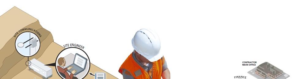
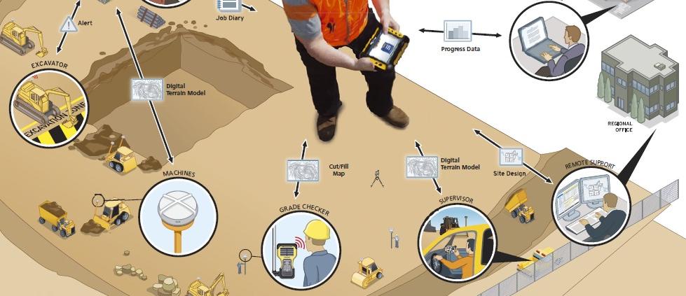
4 Trimble Construction Connected Site


5 Accuracy is application dependent Trimble DGPS: 0.5m Trimble SparseVRS: <10cm Trimble VRS RTK: 1 2 cm Trimble RTX: 2 4 cm Standalone GPS: 5 10 m
6 Example Trimble Products GPS/GLN/Galileo/QZSS/BeiDou/SBAS/OmniSTAR
7 Trimble High Level GNSS Requirements As many satellites as possible Allows operation in GNSS Hostile environments Trimble track all GNSS signals in space today Improves accuracy (averages multipath / better geometry) Compatible signals Different codes, modulations are easy to manage Moore s law continues to shrink the digital electronics Increasing number of RF bands harder to shrink Result in higher power and more expensive products Known coordinate reference frame offsets Spectrum Protection Open access to ICDs 2 or 3 frequencies per system RTK/RTX etc.
8 Frequencies Already capable of tracking everything in space today L1, L2, L5, E5A, E5B, E5AltBOC, LEX, B1, B2 etc Where possible new signals should stick to the existing 4 bands: L1 - Greater L1 band (B1 thru to the top of GLONASS L1) L2 - GPS/GLONASS L2 L5 - L5/E5A/E5B/B2 L6 - E6/LEX/B3 Due to the number of available satellites on each band Trimble products are as follows: L1 + L2 low end legacy devices L1 + L2 + L5 becoming the minimum for precision markets L1 + L2 + L5 + L6 high end devices Sticking to these frequencies prevents the need for more complex antennas (larger) and additional radio front-ends (size/power) Frequency offsets within this band are relatively easy to handle in the digital baseband and data processing CDMA is the preferred modulation, avoids biases of FDMA Although committed to supporting GLONASS FDMA We have not fully evaluated frequencies beyond L-Band Challenge is developing a small antenna with a very stable phase center Requires an extra down-converter (size/power) Already have tri-lane RTK capability in shipping products
9 Modulation Key requirement is low noise measurements Navigation data message is important, but the measurements are the most critical Preference would be more power in a pilot versus data channel TTFF not as important in the precision market Common Spectrum (e.g. GPS MBOC and Galileo CBOC) Both signals providing a lower noise (esp. multipath) signal compared to BPSK is very positive However to optimally demodulate these signals there are differences required in the channel configuration for MBOC and CBOC. Favour future modulations that have inherent multipath mitigation, e.g. AltBOC compared to regular BPSK. Wider bandwidths help with multipath mitigation Select the lowest noise signal from each band/system (e.g. on Galileo E5 the preferred signal is AltBOC although the engine is capable of using the other signals) Code and carrier need to be locked together at transmission All navigation signals transmitted from a common point in space
10 Data Processing Today compute GPS, GLONASS, Galileo clock offsets QZSS is treated as a GPS satellite and we have the advantage of not needing to compute the clock offset When Galileo is active we ll evaluate whether the transmitted offset of the receiver calculated one is the most accurate Preferred method of getting data is over the satellite to cover all user cases Although internet delivery in some applications has advantages to rapidly bootstrap a receiver Datum Offsets For short to moderate length baselines small datum offsets have minimal impact Large datum offsets are an issue (e.g. PZ90 prior to PZ90.1) For RTX Trimble compute our own orbits and clocks in the current epoch of ITRF BeiDou s transmission of differential corrections on the GEOs is an interesting concept and is being evaluated. Trimble s philosophy is track everything that is available Analyze the data in real time and use everything that meets selection criteria In a benign environment more signals relative to today have a marginal impact The benefit is in a hostile environment (masking, trees etc)
11 Operators / International Community Spectrum Protection is very important Products in the precision market have a very long life While small datum shifts can be tolerated knowledge of the datums is important Open ICD access Preferably before the satellites are launched (the precision market has a lot of early adopters) All current systems are now open! Publication of guaranteed performance levels Even better real time access to current global performance
GNSS Accuracy Improvements through Multipath Mitigation with New Signals and services
 GNSS Accuracy Improvements through Multipath Mitigation with New Signals and services Andrey Veytsel, Ph.D Moscow Technical University 10 Meeting of the International Committee on Global Navigation Satellite
GNSS Signal Structures
 GNSS Signal Structures Tom Stansell Stansell Consulting Tom@Stansell.com Bangkok, Thailand 23 January 2018 S t a n s e l l C o n s u l t i n g RL Introduction It s a pleasure to speak with you this morning.
High Precision Applications with BeiDou
 High Precision Applications with BeiDou Lei HUANG Unicore Communications, Inc May 14, 2013 Contents 1 2 3 4 Background Overview of BeiDou high precision products Applications of BeiDou high precision products
The report of Japan GNSS Interoperability Workshop. November 12th 2014 Quasi-Zenith Satellite System Services Inc.
 The report of Japan GNSS Interoperability Workshop November 12th 2014 Quasi-Zenith Satellite System Services Inc. Quasi-Zenith Satellite System Services Inc. 2014 Japan GNSS Interoperability Workshop Date
BeiDou Next Generation Signal Design and Expected Performance
 International Technical Symposium on Navigation and Timing ENAC, 17 Nov 2015 BeiDou Next Generation Signal Design and Expected Performance Challenges and Proposed Solutions Zheng Yao Tsinghua University
Field experience with future GNSS ranging signals (a review). A.Simsky, J.-M. Sleewaegen, W. De Wilde Septentrio, Belgium
. A.Simsky, J.-M. Sleewaegen, W. De Wilde Septentrio, Belgium") Field experience with future GNSS ranging signals (a review). A.Simsky, J.-M. Sleewaegen, W. De Wilde Septentrio, Belgium Technical University of Munich June 07 2010 Contents Septentrio: company profile
Field experience with future GNSS ranging signals (a review). A.Simsky, J.-M. Sleewaegen, W. De Wilde Septentrio, Belgium Technical University of Munich June 07 2010 Contents Septentrio: company profile
The International Scene: How Precise Positioning Will Underpin Critical GNSS Applications
 The International Scene: How Precise Positioning Will Underpin Critical GNSS Applications School of Civil & Environmental Engineering, UNSW, Sydney, Australia Chris Rizos Member of the IGS Governing Board
One Source for Positioning Success
 novatel.com One Source for Positioning Success RTK, PPP, SBAS OR DGNSS. NOVATEL CORRECT OPTIMIZES ALL CORRECTION SOURCES, PUTTING MORE POWER, FLEXIBILITY AND CONTROL IN YOUR HANDS. NovAtel CORRECT is the
Relative positioning with Galileo E5 AltBOC code measurements
 Relative positioning with Galileo E5 AltBOC code measurements Dissertation submitted to the University of Liège in requirements for a Master s degree in Geomatics and Geometrology Cécile Deprez PhD Candidate
Trimble GNSS Infrastructure
 Trimble GNSS Infrastructure A History of Innovation Trimble, the first company to offer commercial GPS products company to integrate GPS with communications technology RTK system in the market in 1994
New Signal Structures for BeiDou Navigation Satellite System
 Stanford's 2014 PNT Symposium New Signal Structures for BeiDou Navigation Satellite System Mingquan Lu, Zheng Yao Tsinghua University 10/29/2014 1 Outline 1 Background and Motivation 2 Requirements and
Update on GPS L1C Signal Modernization. Tom Stansell Aerospace Consultant GPS Wing
 Update on GPS L1C Signal Modernization Tom Stansell Aerospace Consultant GPS Wing Glossary BOC = Binary Offset Carrier modulation C/A = GPS Coarse/Acquisition code dbw = 10 x log(signal Power/1 Watt) E1
Foreword by Glen Gibbons About this book Acknowledgments List of abbreviations and acronyms List of definitions
 Table of Foreword by Glen Gibbons About this book Acknowledgments List of abbreviations and acronyms List of definitions page xiii xix xx xxi xxv Part I GNSS: orbits, signals, and methods 1 GNSS ground
An Industry View on Realistic Benefits for High Precision GNSS Applications due to GNSS Modernisation The Future of High Precision GNSS
 An Industry View on Realistic Benefits for High Precision GNSS Applications due to GNSS Modernisation The Future of High Precision GNSS Bernhard Richter GNSS Business Director at Leica Geosystems 1 Content
Assessment of GNSS Ionospheric Scintillation and TEC Monitoring Using the Multi-constellation GPStation-6 Receiver
 Assessment of GNSS Ionospheric Scintillation and TEC Monitoring Using the Multi-constellation GPStation-6 Receiver Rod MacLeod Regional Manager Asia/Pacific NovAtel Australia Pty Ltd Outline Ionospheric
Future GNSS: Improved Signals and Constellations
 Future GNSS: Improved Signals and Constellations Guillermo Martínez Morán 1 1 Airbus Defense & Space. Paseo John Lennon s/n 28096 Getafe (Madrid Spain) Guillermo.M.Martinez@military.airbus.com Abstract:
GNSS Low-Cost High-Accuracy Receiver (L-CHAR)
") GNSS Low-Cost High-Accuracy Receiver (L-CHAR) Dinesh Manandhar Center for Spatial Information Science The University of Tokyo Contact Information: dinesh@iis.u-tokyo.ac.jp Slide : 1 High Accuracy Receivers
GNSS Low-Cost High-Accuracy Receiver (L-CHAR) Dinesh Manandhar Center for Spatial Information Science The University of Tokyo Contact Information: dinesh@iis.u-tokyo.ac.jp Slide : 1 High Accuracy Receivers
GNSS Technology Update
 GNSS Technology Update Speaker: Eric Gakstatter Contributing Editor GPS World Editor - Geospatial Solutions Presented at: Association of Petroleum Surveying & Geomatics Houston, TX April 7, 2015 Agenda
ION ITM Tokyo University of Marine Science and Technology H. Sridhara, N. Kubo, R.Kikuchi
 Single-Frequency Multi-GNSS RTK Positioning for Moving Platform ION ITM 215 215.1.27-29 Tokyo University of Marine Science and Technology H. Sridhara, N. Kubo, R.Kikuchi 1 Agenda Motivation and Background
Signal Structures for Satellite-Based Navigation: Past, Present, and Future*
 Signal Structures for Satellite-Based Navigation: Past, Present, and Future* John W. Betz 23 April 2013 *Approved for Public Release; Distribution Unlimited. 13-0908. The contents of this material reflect
GNSS Interoperability Enabling the Unknown Future
 GNSS Interoperability Enabling the Unknown Future Tom Stansell Consultant to The Aerospace Corporation Tom@Stansell.com CSNC 2014 Nanjing, China The Aerospace Corporation 2014 Disclaimer: The views and
Future of GNSS Receivers. Éamonn Glennon
 Future of GNSS Receivers Éamonn Glennon Future of GNSS Receivers? What have we got now? What do customers want? What does government want? What are the problems with current receivers? What type of receivers?
Webinar. 9 things you should know about centimeter-level GNSS accuracy
 Webinar 9 things you should know about centimeter-level GNSS accuracy Webinar agenda 9 things you should know about centimeter-level GNSS accuracy 1. High precision GNSS challenges 2. u-blox F9 technology
Professional GNSS solutions in challenging environments
 Professional GNSS solutions in challenging environments Company history 2000 Septentrio is founded as a spin-off from IMEC, world s premier semiconductor research center and still a strong partner & shareholder.
Status of COMPASS/BeiDou Development
 Status of COMPASS/BeiDou Development Stanford s 2009 PNT Challenges and Opportunities Symposium October 21-22,2009 Cao Chong China Technical Application Association for GPS Contents 1. Basic Principles
CHC MINING DEFORMATION MONITORING SOLUTION
 CHC MINING DEFORMATION MONITORING SOLUTION Safety is first in mining. CHC offers solutions designed to improve safety for personnel on the ground and in the cab with 24/7 precision positioning for automatic
Introduction to Global Navigation Satellite System (GNSS) Signal Structure
 Signal Structure") Introduction to Global Navigation Satellite System (GNSS) Signal Structure Dinesh Manandhar Center for Spatial Information Science The University of Tokyo Contact Information: dinesh@iis.u-tokyo.ac.jp
Introduction to Global Navigation Satellite System (GNSS) Signal Structure Dinesh Manandhar Center for Spatial Information Science The University of Tokyo Contact Information: dinesh@iis.u-tokyo.ac.jp
Understanding GPS: Principles and Applications Second Edition
 Understanding GPS: Principles and Applications Second Edition Elliott Kaplan and Christopher Hegarty ISBN 1-58053-894-0 Approx. 680 pages Navtech Part #1024 This thoroughly updated second edition of an
The added value of new GNSS to monitor the ionosphere
 The added value of new GNSS to monitor the ionosphere R. Warnant 1, C. Deprez 1, L. Van de Vyvere 2 1 University of Liege, Liege, Belgium. 2 M3 System, Wavre, Belgium. Monitoring TEC for geodetic applications
Specifications. Trimble BX982 Modular GNSS Heading Receiver
 Name Configuration Option Base and Rover interchangeability Rover position update rate Rover maximum range from base radio Rover operation within a VRS network Heading and Moving Base operation Factory
Surveying in the Year 2020
 Surveying in the Year 2020 Johannes Schwarz Leica Geosystems My first toys 2 1 3 Questions Why is a company like Leica Geosystems constantly developing new surveying products and instruments? What surveying
NovAtel Precise Thinking Makes it Possible
 NovAtel Precise Thinking Makes it Possible Advantages of Multi-Frequency Multi-Constellation GNSS Thomas Morley, Product Manager Outline Who am I? What is GNSS? Where are we today with respect to GNSS?
SSR Technology for Scalable Real-Time GNSS Applications
 SSR Technology for Scalable Real-Time GNSS Applications Gerhard Wübbena, Jannes Wübbena, Temmo Wübbena, Martin Schmitz Geo++ GmbH 30827 Garbsen, Germany www.geopp.de Abstract SSR Technology for scalable
The Benefits of Three Frequencies for the High Accuracy Positioning
 The Benefits of Three Frequencies for the High Accuracy Positioning Nobuaki Kubo (Tokyo University of Marine and Science Technology) Akio Yasuda (Tokyo University of Marine and Science Technology) Isao
Introduction to GNSS Base-Station
 Introduction to GNSS Base-Station Dinesh Manandhar Center for Spatial Information Science The University of Tokyo Contact Information: dinesh@iis.u-tokyo.ac.jp Slide : 1 Introduction GPS or GNSS observation
CNES contribution to GALILEO signals design JC2. Jean-Luc Issler
 CNES contribution to GALILEO signals design JC2 Jean-Luc Issler INTRODUCTION GALILEO Signals have been designed by the members of the "GALILEO Signal Task Force(STF)" of the European Commission. CNES was
Understanding GPS/GNSS
 Understanding GPS/GNSS Principles and Applications Third Edition Contents Preface to the Third Edition Third Edition Acknowledgments xix xxi CHAPTER 1 Introduction 1 1.1 Introduction 1 1.2 GNSS Overview
GNSS & Coordinate Systems
 GNSS & Coordinate Systems Matthew McAdam, Marcelo Santos University of New Brunswick, Department of Geodesy and Geomatics Engineering, Fredericton, NB May 29, 2012 Santos, 2004 msantos@unb.ca 1 GNSS GNSS
GNSS 101 Bringing It Down To Earth
 GNSS 101 Bringing It Down To Earth Steve Richter Frontier Precision, Inc. UTM County Coordinates NGVD 29 State Plane Datums Scale Factors Projections Session Agenda GNSS History & Basic Theory Coordinate
GLONASS: Current status and perspectives
 Federal Space Agency GLONASS: Current status and perspectives 3rd ALLSAT Open conference Hannover, June 22, 2006 Vyacheslav DVORKIN, Sergey KARUTIN Russian Institute of Space Device Engineering 53, Aviamotornaya
What is a GPS How does GPS work? GPS Segments GPS P osition Position Position Accuracy Accuracy Accuracy GPS A pplications Applications Applications
 What is GPS? What is a GPS How does GPS work? GPS Segments GPS Position Accuracy GPS Applications What is GPS? The Global Positioning System (GPS) is a precise worldwide radio-navigation system, and consists
King AbdulAziz University. Faculty of Environmental Design. Geomatics Department. Mobile GIS GEOM 427. Lecture 3
 King AbdulAziz University Faculty of Environmental Design Geomatics Department Mobile GIS GEOM 427 Lecture 3 Ahmed Baik, Ph.D. Email: abaik@kau.edu.sa Eng. Fisal Basheeh Email: fbasaheeh@kau.edu.sa GNSS
High Precision GNSS in Automotive
 High Precision GNSS in Automotive Jonathan Auld, VP Engineering and Safety 6, March, 2018 2 Global OEM Positioning Solutions and Services for Land, Sea, and Air. GNSS in Automotive Today Today the primary
Development of an Open Source Multi GNSS Data Processing Software
 2nd Asia Oceania Regional Workshop on GNSS 2010 Development of an Open Source Multi GNSS Data Processing Software Tomoji TAKASU Tokyo University of Marine Science and Technology Contents Introduction Issues
Real-Time and Multi-GNSS Key Projects of the International GNSS Service
 Real-Time and Multi-GNSS Key Projects of the International GNSS Service Urs Hugentobler, Chris Rizos, Mark Caissy, Georg Weber, Oliver Montenbruck, Ruth Neilan EUREF 2013 Symposium Budapest, Hungary, May
FieldGenius Technical Notes GPS Terminology
 FieldGenius Technical Notes GPS Terminology Almanac A set of Keplerian orbital parameters which allow the satellite positions to be predicted into the future. Ambiguity An integer value of the number of
ORBITAL NAVIGATION SYSTEMS PRESENT AND FUTURE TENDS
 ORBITAL NAVIGATION SYSTEMS PRESENT AND FUTURE TENDS CONTENT WHAT IS COVERED A BRIEF HISTORY OF SYSTEMS PRESENT SYSTEMS IN USE PROBLEMS WITH SATELLITE SYSTEMS PLANNED IMPROVEMENTS CONCLUSION CONTENT WHAT
GNSS MONITORING NETWORKS
 SPACE GNSS MONITORING NETWORKS Satellite communications, earth observation, navigation and positioning and control stations indracompany.com GNSS MONITORING NETWORKS GNSS MONITORING NETWORKS Indra s solutions
MGA Webinar Series : 1 Very Cheap RTK Receivers: Changing the Landscape of Positioning Services
 MGA Webinar Series : 1 Very Cheap RTK Receivers: Changing the Landscape of Positioning Services Dinesh Manandhar Center for Spatial Information Science The University of Tokyo Contact Information: dinesh@iis.u-tokyo.ac.jp
A GLONASS Observation Message Compatible With The Compact Measurement Record Format
 A GLONASS Observation Message Compatible With The Compact Measurement Record Format Leica Geosystems AG 1 Introduction Real-time kinematic (RTK) Global Navigation Satellite System (GNSS) positioning has
Signals, and Receivers
 ENGINEERING SATELLITE-BASED NAVIGATION AND TIMING Global Navigation Satellite Systems, Signals, and Receivers John W. Betz IEEE IEEE PRESS Wiley CONTENTS Preface Acknowledgments Useful Constants List of
Precise Positioning with Smartphones running Android 7 or later
 Precise Positioning with Smartphones running Android 7 or later * René Warnant, * Cécile Deprez, + Quentin Warnant * University of Liege Geodesy and GNSS + Augmenteo, Plaine Image, Lille (France) Belgian
Positioning with Single and Dual Frequency Smartphones Running Android 7 or Later
 Positioning with Single and Dual Frequency Smartphones Running Android 7 or Later * René Warnant, *Laura Van De Vyvere, + Quentin Warnant * University of Liege Geodesy and GNSS + Augmenteo, Plaine Image,
Preparing for the Future The IGS in a Multi-GNSS World
 Preparing for the Future The IGS in a Multi-GNSS World O. Montenbruck DLR/GSOC 1 The International GNSS Service is a federation of more than 200 institutions and organizations worldwide a Service of the
CH GPS/GLONASS/GALILEO/SBAS Signal Simulator. General specification Version 0.2 Eng. Preliminary
 CH-380 GPS/GLONASS/GALILEO/SBAS Signal Simulator General specification Version 0.2 Eng Preliminary Phone: +7 495 665 648 Fax: +7 495 665 649 navis@navis.ru NAVIS-UKRAINE Mazura str. 4 Smela, Cherkassy
Prospect for Global Positioning Augmentation Service by QZSS
 Prospect for Global Positioning Augmentation Service by QZSS Global Positioning Augmentation Service Corporation Director, Yoshikatsu Iotake Feb. 6, 2018 Copyright 2018 Global Positioning Augmentation
Where Next for GNSS?
 Where Next for GNSS? Professor Terry Moore Professor of Satellite Navigation Nottingham The University of Nottingham Where Next for GNSS Back to the Future? Professor Terry Moore Professor of Satellite
DEFINING THE FUTURE OF SATELLITE SURVEYING WITH TRIMBLE R-TRACK TECHNOLOGY
 DEFINING THE FUTURE OF SATELLITE SURVEYING WITH TRIMBLE R-TRACK TECHNOLOGY EDMOND NORSE, GNSS PORTFOLIO MANAGER, TRIMBLE SURVEY DIVISION WESTMINSTER, CO USA ABSTRACT In September 2003 Trimble introduced
GPS for. Land Surveyors. Jan Van Sickle. Fourth Edition. CRC Press. Taylor & Francis Group. Taylor & Francis Croup, an Informa business
 GPS for Land Surveyors Fourth Edition Jan Van Sickle CRC Press Taylor & Francis Group Boca Raton London New York CRC Press is an imprint of the Taylor & Francis Croup, an Informa business Contents Preface
POWERGPS : A New Family of High Precision GPS Products
 POWERGPS : A New Family of High Precision GPS Products Hiroshi Okamoto and Kazunori Miyahara, Sokkia Corp. Ron Hatch and Tenny Sharpe, NAVCOM Technology Inc. BIOGRAPHY Mr. Okamoto is the Manager of Research
Introduction to Total Station and GPS
 Introduction to Total Station and GPS Dr. P. NANJUNDASWAMY Professor of Civil Engineering J S S Science and Technology University S J College of Engineering Mysuru 570 006 Introduction History GPS Overview
GNSS Modernisation and Its Effect on Surveying
 Lawrence LAU and Gethin ROBERTS, China/UK Key words: GNSS Modernisation, Multipath Effect SUMMARY GPS and GLONASS modernisation is being undertaken. The current GPS modernisation plan is expected to be
Precise positioning in multi-gnss mode
 Precise positioning in multi-gnss mode Novembre 2017 ± Compatibilities between GNSS Lower L-Band Upper L-Band E5a+b E1 E5a E5b E6 L1 L5 B2 B2 L2 B3 B1 B1 Frequency (Mhz) GPS Galileo BeiDou BeiDou BeiDou
Best field practices for GIS Data collection: Presented by, Jacob Wittenberg Frontier Precision, Inc.
 Best field practices for GIS Data collection: Presented by, Jacob Wittenberg Frontier Precision, Inc. Agenda What is GNSS Code and Carrier Data H-Star Processing Best Practices Code and Carrier Solutions
Evaluation of Multi-Constellation GNSS Precise Point Positioning (PPP) Techniques in Egypt
 Techniques in Egypt") Evaluation of Multi-Constellation GNSS Precise Point Positioning (PPP) Techniques in Egypt Mahmoud Abd Rabbou and Adel El-Shazly Department of Civil Engineering, Cairo University Presented by; Dr. Mahmoud
Evaluation of Multi-Constellation GNSS Precise Point Positioning (PPP) Techniques in Egypt Mahmoud Abd Rabbou and Adel El-Shazly Department of Civil Engineering, Cairo University Presented by; Dr. Mahmoud
Asian Journal of Science and Technology Vol. 08, Issue, 11, pp , November, 2017 RESEARCH ARTICLE
 Available Online at http://www.journalajst.com ASIAN JOURNAL OF SCIENCE AND TECHNOLOGY ISSN: 0976-3376 Asian Journal of Science and Technology Vol. 08, Issue, 11, pp.6697-6703, November, 2017 ARTICLE INFO
DYNAMIC POSITIONING CONFERENCE October 7-8, Sensors I. Integrating Other GNSS with GPS and its Implication for DP Positioning
 Return to Session Directory DYNAMIC POSITIONING CONFERENCE October 7-8, 2008 Sensors I Integrating Other GNSS with GPS and its Implication for DP Positioning Dr. David Russell Veripos/Subsea 7 (Aberdeen,
Multi-GNSS Environment. Chris Rizos UNSW, Australia President IAG
 Multi-GNSS Environment Chris Rizos UNSW, Australia President IAG Visit official GNSS web sites: GPS - www.navcen.uscg.gov & www.gps.gov GLONASS - glonass-ianc.rsa.ru/en/ Galileo - www.esa.int/our_activities/navigation
Precise Positioning... what does it mean? Precise GNSS Positioning Not just a niche technology. Chris Rizos 15/12/15
 Precise GNSS Positioning Not just a niche technology Chris Rizos Precise Positioning... what does it mean? 1 Precise Positioning... a spectrum of users... Few mm 1cm 2cm < dm 1dm sub-m Precision agriculture
Benefits and Limitations of New GNSS Signal Designs. Dr. A. J. Van Dierendonck AJ Systems, USA November 18, 2014
 Benefits and Limitations of New GNSS Signal Designs Dr. A. J. Van Dierendonck AJ Systems, USA November 18, 2014 My Opinions on New GNSS Signal Designs This briefing is loosely based upon Leadership Series
Effect of Quasi Zenith Satellite (QZS) on GPS Positioning
 on GPS Positioning") Effect of Quasi Zenith Satellite (QZS) on GPS ing Tomoji Takasu 1, Takuji Ebinuma 2, and Akio Yasuda 3 Laboratory of Satellite Navigation, Tokyo University of Marine Science and Technology 1 (Tel: +81-5245-7365,
Effect of Quasi Zenith Satellite (QZS) on GPS ing Tomoji Takasu 1, Takuji Ebinuma 2, and Akio Yasuda 3 Laboratory of Satellite Navigation, Tokyo University of Marine Science and Technology 1 (Tel: +81-5245-7365,
RELEASE NOTES. Trimble Infrastructure GNSS Series Receivers. Introduction. New features or changes. Updating the firmware
 RELEASE NOTES Trimble Infrastructure GNSS Series Receivers Introduction New features or changes Updating the firmware Version 4.42 Revision A June 2011 F Corporate office Trimble Navigation Limited Engineering
Introduction to Geographic Information Science. Last Lecture. Today s Outline. Geography 4103 / GNSS/GPS Technology
 Geography 4103 / 5103 Introduction to Geographic Information Science GNSS/GPS Technology Last Lecture Geoids Ellipsoid Datum Projection Basics Today s Outline GNSS technology How satellite based navigation
RACELOGIC Antenna and Mount Options
 Antenna Options Your choice of antenna is critical to the accuracy of measurement. Racelogic provide a number of different antenna options, depending upon the measurement system, the type of vehicle being
PRINCIPLES AND FUNCTIONING OF GPS/ DGPS /ETS ER A. K. ATABUDHI, ORSAC
 PRINCIPLES AND FUNCTIONING OF GPS/ DGPS /ETS ER A. K. ATABUDHI, ORSAC GPS GPS, which stands for Global Positioning System, is the only system today able to show you your exact position on the Earth anytime,
Fast convergence of Trimble CenterPoint RTX by regional augmentation
 Fast convergence of Trimble CenterPoint RTX by regional augmentation Dr. Ralf Drescher Trimble Terrasat GmbH, Munich EGU General Assembly 2015, Vienna Thursday, 16 April 2015 Outline Introduction CenterPoint
ProMark 500 White Paper
 ProMark 500 White Paper How Magellan Optimally Uses GLONASS in the ProMark 500 GNSS Receiver How Magellan Optimally Uses GLONASS in the ProMark 500 GNSS Receiver 1. Background GLONASS brings to the GNSS
DYNAMIC RT TECHNOLOGY
 DYNAMIC RT TECHNOLOGY GLOBAL NAVIGATION SATELLITE SYSTEMS (GNSS) POTENTIAL FUTURE DEVELOPMENTS(2005 2017?) GPS MODERNIZATION BLOCK IIF & III GLONASS ENHANCEMENTS (K & M) EUROPEAN UNION - GALILEO CHINA
As is well known, Galileo will. Airborne Applications. Issues and Perspectives
 GLONASS-K for Airborne Applications Issues and Perspectives Pierre-Yves Dumas Thales Avionics As the Russian GLONASS constellation approaches completion, the planned addition of new CDMA signals has renewed
Applications, Products and Services of GPS Technology
 Applications, Products and Services of GPS Technology Enrico C. Paringit. Dr. Eng. University of the Philippines Training Center for Applied Geodesy and Photogrammetry 1 Outline of this Presentation GPS
Precise Positioning with NovAtel CORRECT Including Performance Analysis
 Precise Positioning with NovAtel CORRECT Including Performance Analysis NovAtel White Paper April 2015 Overview This article provides an overview of the challenges and techniques of precise GNSS positioning.
AGENDA. NEI Overview. Mobile platforms with the new R1 / R2 GNSS receiver. High Accuracy Cloud Based Data Collection. Geo 7X Higher Accuracy Option
 AGENDA NEI Overview Mobile platforms with the new R1 / R2 GNSS receiver High Accuracy Cloud Based Data Collection Geo 7X Higher Accuracy Option Selecting - the Right Tool for the Right Job Field to Finish.
GE 113 REMOTE SENSING
 GE 113 REMOTE SENSING Topic 9. Introduction to Global Positioning Systems (GPS) and Other GNSS Technologies Lecturer: Engr. Jojene R. Santillan jrsantillan@carsu.edu.ph Division of Geodetic Engineering
Comparative analysis of GNSS Real Time Kinematic methods for navigation
 IAV Hassan II Comparative analysis of GNSS Real Time Kinematic methods for navigation Mourad BOUZIANI School of Geomatic Sciences, IAV Hassan II, Rabat, Morocco. Coordinator of the Master - GNSS, IAV&
Case sharing of the use of RF Localization Techniques. Dr. Frank Tong LSCM R&D Centre LSCM Summit 2015
 Case sharing of the use of RF Localization Techniques Dr. Frank Tong LSCM R&D Centre LSCM Summit 2015 Outline A. LBS tracking and monitoring 1) Case of anti-wandering-off tracking vest system in elderly
GALILEO Applications. Andreas Schütz Training on GNSS T131 / T151 Bangkok, January 14th 2019
 GALILEO Applications Andreas Schütz Training on GNSS T131 / T151 Bangkok, January 14th 201 Overview GNSS Downstream Applications overview The GALILEO Open Service The GALILEO Public Regulated Service The
SURVEYORS BOARD OF QUEENSLAND. RTK GNSS for Cadastral Surveys. Guideline
 SURVEYORS BOARD OF QUEENSLAND RTK GNSS for Cadastral Surveys Guideline 30 November 2012 RTK GNSS for Cadastral Surveys General The Surveyors Board of Queensland has recently become aware of some issues
GNSS for UAV Navigation. Sandy Kennedy Nov.15, 2016 ITSNT
 GNSS for UAV Navigation Sandy Kennedy Nov.15, 2016 ITSNT Sounds Easy Enough Probably clear open sky conditions?» Maybe not on take off and landing Straight and level flight?» Not a valid assumption for
DYNAMIC POSITIONING CONFERENCE October 7-8, Sensors II. Redundancy in Dynamic Positioning Systems Based on Satellite Navigation
 Return to Session Directory DYNAMIC POSITIONING CONFERENCE October 7-8, 2008 Sensors II Redundancy in Dynamic Positioning Systems Based on Satellite Navigation Ole Ørpen, Tor Egil Melgård, Arne Norum Fugro
Positioning Australia for its farming future
 Positioning Australia for its farming future Utilizing the Japanese satellite navigation QZSS system to provide centimetre positioning accuracy across ALL Australia David Lamb 1,2 and Phil Collier 2 1
GLObal Navigation Satellite System (GLONASS)
") FEDERAL SPACE AGENCY GLObal Navigation Satellite System (GLONASS) Sergey Revnivykh Deputy Director General Central Research Institute of Machine Building Head of PNT Center 4-th meeting of International
FEDERAL SPACE AGENCY GLObal Navigation Satellite System (GLONASS) Sergey Revnivykh Deputy Director General Central Research Institute of Machine Building Head of PNT Center 4-th meeting of International
GBAS FOR ATCO. June 2017
 GBAS FOR ATCO June 2017 Disclaimer This presentation is for information purposes only. It should not be relied on as the sole source of information, and should always be used in the context of other authoritative
Indian GNSS Industry Overview Challenges and future prospects
 Indian GNSS Industry Overview Challenges and future prospects Expert Presentation By Dr. S.V. Kibe Consultant, SATCOM & GNSS, Bangalore, India (Former Programme Director, SATNAV,ISRO HQ) On February 20,2013
Current status of Quasi-Zenith Satellite System. Japan Aerospace Exploration Agency QZSS Project Team
 Current status of Quasi-Zenith Satellite System Japan Aerospace Exploration Agency QZSS Project Team 1 Quasi-Zenith Satellite System The QZSS is a regional space-based PNT (Positioning, Navigation and
SERVIR: The Portuguese Army CORS Network for RTK
 SERVIR: The Portuguese Army CORS Network for RTK António Jaime Gago AFONSO, Rui Francisco da Silva TEODORO and Virgílio Brito MENDES, Portugal Key words: GNSS, RTK, VRS, Network ABSTRACT Traditionally
Specifications. Trimble SPS555H Heading Add-on Receiver
 Receiver Name Configuration Option Base and Rover interchangeability Rover position update rate Rover maximum range from base radio Rover operation within a VRS network Heading and Moving Base operation
PPP with Ambiguity Resolution (AR) using RTCM-SSR
 using RTCM-SSR") PPP with Ambiguity Resolution (AR) using RTCM-SSR Gerhard Wübbena, Martin Schmitz, Andreas Bagge Geo++ GmbH 30827 Garbsen Germany www.geopp.de PPP with Ambiguity Resolution (AR) using RTCM-SSR Abstract
PPP with Ambiguity Resolution (AR) using RTCM-SSR Gerhard Wübbena, Martin Schmitz, Andreas Bagge Geo++ GmbH 30827 Garbsen Germany www.geopp.de PPP with Ambiguity Resolution (AR) using RTCM-SSR Abstract
Report of Working Group B: Enhancement of Global Navigation Satellite Systems Services Performance
 Report of : Enhancement of Global Navigation Satellite Systems Services Performance 1. The Working Group on Enhancement of Global Navigation Satellite Systems (GNSS) Service Performance (WG-B) of the International
Recommendation 16-A for Committee Decision
 Recommendation 16-A for Committee Decision Information on the works related to the proposed redefinition of UTC (revision of Recommendation 16 (2012) Considering that: the navigation systems have unique
Accuracy assessment of free web-based online GPS Processing services and relative GPS solution software
 82 Accuracy assessment of free web-based online GPS Processing services and relative GPS solution software Khaled Mahmoud Abdel Aziz Department of Surveying Engineering, Shoubra Faculty of Engineering,