GLONASS: Current status and perspectives
|
|
|
- Alice Lawson
- 6 years ago
- Views:
Transcription
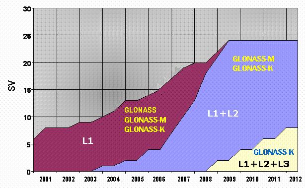
1 Federal Space Agency GLONASS: Current status and perspectives 3rd ALLSAT Open conference Hannover, June 22, 2006 Vyacheslav DVORKIN, Sergey KARUTIN Russian Institute of Space Device Engineering 53, Aviamotornaya str, Moscow Russia
2 Content State Policy principles GLONASS current status GLONASS modernization plans GLONASS augmentations
3 State policy principles No direct user fees exist for the GLONASS service Open access is guaranteed to the GLONASS signal structure for user equipment and applications development Application of combined GLONASS/GPS receivers is promoted within Russian territory Compatibility and interoperability of GLONASS with GPS and future GALILEO has to be maintained GLONASS involvement in the GNSS global markets is a target
4 State policy juristic fundamentals President Resolution, 1999 Government Resolution, 1999 Federal Program «Global Navigation System» (GLONASS program),, 2001 Concept of Russian Federation united position navigation and time system, 2004 GLONASS is a basement of united position navigation and time service
5 Basic topics of federal GLONASS program GLONASS system maintenance and development Minimum constellation size (18 satellites) 2007 Full constellation (24 satellites) 2009 Development and production of the GNSS user equipment for all applications Combined GNSS receivers Integrated systems based on GNSS technology Receiver components creation Navigation technology integration into transport infrastructure Geodetic reference frames modernization Federal GLONASS Programme is is directly funded from from the the Federal Budget with with annual corrections
6 Content State Policy principles GLONASS current status GLONASS modernization plans GLONASS augmentations
7 15 15 satellites on on orbit Constellation status 11 SV «GLONASS» (3 yrs life-time): 4 SV «GLONASS-M» (7 yrs life-time time) 2 operational 2 undergo flight test Blok GLONASS-M 15 LT 7yrs GLONASS-M 16 LT 7 yrs GLONASS-M 17 LT 7yrs 5 GLONASS LT 3 yrs GLONASS LT 3 yrs GLONASS LT 3 yrs GLONASS LT 3 yrs GLONASS-M 11Л LT 7 yrs GLONASS-M 12Л LT 7 yrs GLONASS LT 3 yrs Flight test GLONASS LT 3 yrs GLONASS LT 3 yrs GLONASS LT 3 yrs GLONASS LT 3 yrs GLONASS LT 3 yrs GLONASS LT 3 yrs GLONASS-M 13L LT 7 yrs GLONASS-M 14L LT 7 yrs

8 Constellation history and perspectives GLONASS deployment milestones: 18 satellites in constellation satellites in constellation 2009
9 Content State Policy principles GLONASS current status GLONASS modernization plans GLONASS augmentations
10 GLONASS modernization plans Modernization of on-board major components, including payload Navigation signals modernization Upgrade GLONASS ground segment
11 Satellite equipment modernization plans New signals additional transmitters development Intersatellite link creation Navigation message self-descriptiveness increasing
12 Navigation signals
13 GLONASS signals modernization MHz GPS L1 BPSK 5.11/0.511 MHz MHz F = MHz MHz MHz R/A GPS L BPSK 5.11/0.511 MHz MHz F = MHz L2f(i) = 7/9 L1f(i) F MHz MHz E4 GALILEO L3 GPS/GALILEO E5A BPSK MHz MHz F = MHz L3f(i) = 94/125 L1f(i) F E5B GALILEO MHz MHz GLONASS GLONASS-M GLONASS-K

14 GLONASS control segment modernization Modernization program One-way measurement and ephemeris computation stations network development One-way measurement stations network creation Two-way way measurement stations deployment Communication channels modernization
15 Navigation accuracy Ephemeris and clock accuracy (σ)( along track, м 5 3,5 1,5 1,2 1 cross track, м 5 3,5 1 0,8 0,5 radius, м 1 0, ,25 0,25 synchronization, ns Positioning accuracy (σ)( horizontal, m vertical, m Positioning error (3σ), m
16 Content State Policy principles GLONASS current status GLONASS modernization plans GLONASS augmentations
17 GLONASS augmentations Russian wide-area differential subsystem GLONASS/GPS integrity monitoring subsystem Regional differential subsystems
18 Russian system for differential correction and monitoring (SDCM) SDCM goals Based on GLONASS/GPS signals: 1) Provide «meter level» of position determination accuracy in real time horizontal: : m vertical: : m 2) Provide «centimeter level» of position determination in real time (with ground stations support) horizontal: : 1-2 cm по vertical: : 4 6 cm 3) Making operative integrity monitoring 4) Making a posteriori integrity monitoring
19 SDCM architecture GLONASS SV Processing Center GEO. 3 Data gathering points located abroad Upload station. 7 Data gathering points in Russia (as of 2006): 1 Moscow; 2 Pulkovo (S.Petersburg); 3 Kislovodsk; 4 Norilsk; 5 Irkutsk; 6 Petropavlovsk; 7 Khabarovsk; 8 Novosibirsk
20 SDCM development plans Data gathering network development Satellite transponder design and manufacturing 2008 Ground uplink station creation 2008 System flight test
21 Data collection network development program Existing station (end 2005 ): 1 Moscow; 2 Pulkovo (S.Petersburg); 3 Kislovodsk; 4 Norilsk; 5 Irkutsk; 6 Petropavlovsk; 7 Khabarovsk; 8 Novosibirsk Data gathering point (future): 9 Tiksi; 10 Bilibino; 11 Magadan; 12 Yugno-Sahalinsk; 13 Yakutsk; 14 Vladivostok; 15- Ekaterinburg; 16- Lovozero; 17 Voroneg; 18 Anapa; 19 Pecheri.
22 Federal Space Agency Thank you for attention!
23 GLONASS modernization plans Retrofitting ground segment Modernization of the GLONASS time keeping system Improving ground measurement processing techniques to achieve better ephemeris and clock accuracy based on combination of one-way and two-way way measurement Improving stability of onboard satellite clock Improving Geodetic Reference Frame PZ-90 to agree it with ITRF Introduction of the third civil signal in L3 starting with GLONASS-K K in 2008 Providing GLONASS with Search and Rescue capability (starting with GLONASS-K) in a way similar to COSPAS-SARSAT SARSAT
24 Basic Improvements in GLONASS-M M Compared with GLONASS Spacecraft (Details: GLONASS Interface Control Document (ICD), version 5, ) L2 signal is modulated with civil code Better onboard frequency standard (1 10 vs ) Extra parameters are added into navigation message: Accuracy factor (URA analog), temporarily set to not monitored B1,B2 coefficients for calculating UT1 KP sing of coming leap second N4 sequential number of 4-year 4 interval starting with 1996 N T day sequential number within 4-year 4 interval τ n onboard L1/L2 signal delay difference τ GPS GPS/GLONASS time offset τ GPS
GLObal Navigation Satellite System (GLONASS)
") FEDERAL SPACE AGENCY GLObal Navigation Satellite System (GLONASS) Sergey Revnivykh Deputy Director General Central Research Institute of Machine Building Head of PNT Center 4-th meeting of International
FEDERAL SPACE AGENCY GLObal Navigation Satellite System (GLONASS) Sergey Revnivykh Deputy Director General Central Research Institute of Machine Building Head of PNT Center 4-th meeting of International
SDCM present status and future. GLONASS signals development.
 The Eighth Meeting of the International Committee on Global Navigation Satellite Systems, November 9 14, 2013, Dubai SDCM present status and future. GLONASS signals development. Prof. Grigory Stupak, Dr.
System Status and Performance Improvement Prospects
 Communication Геодезия Navigation GLOBAL NAVIGATION SATELLITE SYSTEM (GLONASS): System Status and Performance Improvement Prospects Viktor KOSENKO, First Deputy General Designer First Deputy General Director
GLONASS PROGRAMME UPDATE
 GLONASS PROGRAMME UPDATE Ivan Revnivykh Roscosmos State Space Corporation 11 th Meeting of the International Committee on Global Navigation Satellite System November 7, 2016 Sochi, Russian Federation CONTENTS
Global Navigation Satellite System (GLONASS): Status and Development
: Status and Development") Global Navigation Satellite System (GLONASS): Status and Development Tatiana Mirgorodskaya Information and Analysis Center for Positioning, Navigation and Timing Roscosmos State Corporation UN-Nepal Workshop
Global Navigation Satellite System (GLONASS): Status and Development Tatiana Mirgorodskaya Information and Analysis Center for Positioning, Navigation and Timing Roscosmos State Corporation UN-Nepal Workshop
GLONASS Status and Modernization
 GLONASS Status and Modernization Ekaterina Oleynik Central Research Institute of Roscosmos Federal Space Agency United Nations/Latvia Workshop on the Applications of Global Navigation Satellite Systems
ASSEMBLY 37TH SESSION
 International Civil Aviation Organization WORKING PAPER A37-WP/195 1 22/9/10 (Information paper) ASSEMBLY 37TH SESSION TECHNICAL COMMISSION Agenda Item 35: The Global Air Traffic Management (ATM) System
Lecture-1 CHAPTER 2 INTRODUCTION TO GPS
 Lecture-1 CHAPTER 2 INTRODUCTION TO GPS 2.1 History of GPS GPS is a global navigation satellite system (GNSS). It is the commonly used acronym of NAVSTAR (NAVigation System with Time And Ranging) GPS (Global
MEOSAR & GPS ICG WG-B Vienna Austria, June 2016
 MEOSAR & GPS ICG WG-B Vienna Austria, June 2016 Dr. Lisa Mazzuca, Mission Manager NASA Search and Rescue Office Goddard Space Flight Center 1 Overview Cospas-Sarsat System GNSS-enabled Medium Earth Orbit
Results of the PZ reference frame implementation to GLONASS
 Joint-stock company «RESEARCH-AND-PRODUCTION CORPORATION «PRECISION SYSTEMS AND INSTRUMENTS» Results of the PZ-90.11 reference frame implementation to GLONASS Speaker: Deputy General Director, Deputy Chief
«Current state and prospects of development of commercial application GLONASS/GNSS in the Russian Federation»
 «Current state and prospects of development of commercial application GLONASS/GNSS in the Russian Federation» United Nations SYMPOSIUM TO STRENGTHEN THE PARTNERSHIP WITH INDUSTRY COMMERCIAL APPLICATIONS
GLOBAL NAVIGATION SATELLITE SYSTEMS (GNSS) ECE 2526E Tuesday, 24 April 2018
 ECE 2526E Tuesday, 24 April 2018") GLOBAL NAVIGATION SATELLITE SYSTEMS (GNSS) ECE 2526E Tuesday, 24 April 2018 MAJOR GLOBAL NAVIGATION SATELLITE SYSTEMS (GNSS) Global Navigation Satellite System (GNSS) includes: 1. Global Position System
GLOBAL NAVIGATION SATELLITE SYSTEMS (GNSS) ECE 2526E Tuesday, 24 April 2018 MAJOR GLOBAL NAVIGATION SATELLITE SYSTEMS (GNSS) Global Navigation Satellite System (GNSS) includes: 1. Global Position System
Challenges and Solutions for GPS Receiver Test
 Challenges and Solutions for GPS Receiver Test Presenter: Mirin Lew January 28, 2010 Agenda GPS technology concepts GPS and GNSS overview Assisted GPS (A-GPS) Basic tests required for GPS receiver verification
Future GNSS Precision Applications. Stuart Riley
 Future GNSS Precision Applications Stuart Riley Major Trimble Precision Markets Survey Mostly person portable equipment Construction Machine control and person carried equipment Includes Marine applications
Galileo. 7th ITFS, Rome, Italy, 3-5 November Dr. Stefan Bedrich. Kayser-Threde GmbH Wolfratshauser Str Munich
 Kayser-Threde GmbH Wolfratshauser Str. 48 81379 Munich spacetech@kayser-threde.com Galileo 7th ITFS, Rome, Italy, 3-5 November 2009 Dr. Stefan Bedrich w w w. k a y s e r - t h r e d e. c o m Outline Motivation
THE CREATION OF DIFFERENTIAL CORRECTION SYSTEMS AND THE SYSTEMS OF GLOBAL NAVIGATION SATELLITE SYSTEM MONITORING
 THE CREATION OF DIFFERENTIAL CORRECTION SYSTEMS AND THE SYSTEMS OF GLOBAL NAVIGATION SATELLITE SYSTEM MONITORING G. M. Polishchuk, V. I. Kozlov, Y. M. Urlichich, V. V. Dvorkin, and V. V. Gvozdev Russian
National time scale UTC(SU) and GLONASS system time scale: current status and perspectives
 and GLONASS system time scale: current status and perspectives") State Scientific Center of the Russian Federation National Research Institute for Physical-Technical and Radio Engineering Measurements National time scale UTC(SU) and GLONASS system time scale: current
State Scientific Center of the Russian Federation National Research Institute for Physical-Technical and Radio Engineering Measurements National time scale UTC(SU) and GLONASS system time scale: current
Status of COMPASS/BeiDou Development
 Status of COMPASS/BeiDou Development Stanford s 2009 PNT Challenges and Opportunities Symposium October 21-22,2009 Cao Chong China Technical Application Association for GPS Contents 1. Basic Principles
GNSS Accuracy Improvements through Multipath Mitigation with New Signals and services
 GNSS Accuracy Improvements through Multipath Mitigation with New Signals and services Andrey Veytsel, Ph.D Moscow Technical University 10 Meeting of the International Committee on Global Navigation Satellite
GPS (GNSS) Telecom Time Now and Future 2011 Telcordia-NIST-ATIS Workshop on Synchronization in Telecommunications Systems May 10-12, 2011
 Telecom Time Now and Future 2011 Telcordia-NIST-ATIS Workshop on Synchronization in Telecommunications Systems May 10-12, 2011") GPS (GNSS) Telecom Time Now and Future 2011 Telcordia-NIST-ATIS Workshop on Synchronization in Telecommunications Systems May 10-12, 2011 Marc A. Weiss, Ph.D. Time and Frequency Division National Institute
GPS (GNSS) Telecom Time Now and Future 2011 Telcordia-NIST-ATIS Workshop on Synchronization in Telecommunications Systems May 10-12, 2011 Marc A. Weiss, Ph.D. Time and Frequency Division National Institute
GNSS Programme. Overview and Status in Europe
 GNSS Programme Overview and Status in Europe Inaugural Forum Satellite Positioning Research and Application Center 23 April 2007 Tokyo Presented by Thomas Naecke (European Commission) Prepared by Daniel
Where Next for GNSS?
 Where Next for GNSS? Professor Terry Moore Professor of Satellite Navigation Nottingham The University of Nottingham Where Next for GNSS Back to the Future? Professor Terry Moore Professor of Satellite
Global Navigation Satellite Systems (GNSS)
") Global Navigation Satellite Systems (GNSS) Pat Norris MRAeS, FRIN LogicaCMG Business Development Manager Chairman, RAeS Space Group LogicaCMG 2006. All rights reserved 2 Global Navigation Satellite Systems
Global Navigation Satellite Systems (GNSS) Pat Norris MRAeS, FRIN LogicaCMG Business Development Manager Chairman, RAeS Space Group LogicaCMG 2006. All rights reserved 2 Global Navigation Satellite Systems
Current status of Quasi-Zenith Satellite System. Japan Aerospace Exploration Agency QZSS Project Team
 Current status of Quasi-Zenith Satellite System Japan Aerospace Exploration Agency QZSS Project Team 1 Quasi-Zenith Satellite System The QZSS is a regional space-based PNT (Positioning, Navigation and
Global Positioning Systems Directorate
 Space and Missile Systems Center Global Positioning Systems Directorate GPS Program Update to 8 th Stanford PNT Symposium 30 Oct 2014 Col Matt Smitham Deputy Director, GPS Directorate Global Positioning
Development of BeiDou Navigation Satellite System
 The 8 th Meeting of the International Committee on GNSS Development of BeiDou Navigation Satellite System China Satellite Navigation Office Dubai, UAE November, 2013 Contents Contents 1. Objectives and
LASER GLONASS. Dr. Shargorodskiy Victor, dr. Kosenko Victor, dr. Chubykin Alexey, dr. Pasynkov Vladimir, dr. Sadovnikov Mikhail
 Dr. Shargorodskiy Victor, dr. Kosenko Victor, dr. Chubykin Alexey, dr. Pasynkov Vladimir, dr. Sadovnikov Mikhail Open Joint-stock Company «Research-and-Production Corporation «Precision Systems and Instruments»
GBAS FOR ATCO. June 2017
 GBAS FOR ATCO June 2017 Disclaimer This presentation is for information purposes only. It should not be relied on as the sole source of information, and should always be used in the context of other authoritative
The Indian Regional Navigation. First Position Fix with IRNSS. Successful Proof-of-Concept Demonstration
 Successful Proof-of-Concept Demonstration First Position Fix with IRNSS A. S. GANESHAN, S. C. RATNAKARA, NIRMALA SRINIVASAN, BABU RAJARAM, NEETHA TIRMAL, KARTIK ANBALAGAN INDIAN SPACE RESEARCH ORGANISATION
GNSS: orbits, signals, and methods
 Part I GNSS: orbits, signals, and methods 1 GNSS ground and space segments Global Navigation Satellite Systems (GNSS) at the time of writing comprise four systems, two of which are fully operational and
Principal Investigator Co-Principal Investigator Co-Principal Investigator Prof. Talat Ahmad Vice-Chancellor Jamia Millia Islamia Delhi
 Subject Paper No and Title Module No and Title Module Tag Geology Remote Sensing and GIS Concepts of Global Navigation Satellite RS & GIS XXXIII Principal Investigator Co-Principal Investigator Co-Principal
Views on Interoperability
 Views on Interoperability International Committee on Global Navigation Satellite Systems Prague, November 10 th 14 th 2014 Navigation solutions powered by Europe INTRODUCTION The original purpose of the
DYNAMIC POSITIONING CONFERENCE October 7-8, Sensors II. Redundancy in Dynamic Positioning Systems Based on Satellite Navigation
 Return to Session Directory DYNAMIC POSITIONING CONFERENCE October 7-8, 2008 Sensors II Redundancy in Dynamic Positioning Systems Based on Satellite Navigation Ole Ørpen, Tor Egil Melgård, Arne Norum Fugro
Russian Federation in GNSS Open Service Performance Parameters Template Creation
 Russian Federation in GNSS Open Service Performance Parameters Template Creation Bolkunov Alexey Russian Federal Space Agency Central Scientific-Research Institute for Machine building Information and
NovAtel Precise Thinking Makes it Possible
 NovAtel Precise Thinking Makes it Possible Advantages of Multi-Frequency Multi-Constellation GNSS Thomas Morley, Product Manager Outline Who am I? What is GNSS? Where are we today with respect to GNSS?
Satellite Laser Retroreflectors for GNSS Satellites: ILRS Standard
 Satellite Laser Retroreflectors for GNSS Satellites: ILRS Standard Michael Pearlman Director Central Bureau International Laser Ranging Service Harvard-Smithsonian Center for Astrophysics Cambridge MA
The EU Satellite Navigation programmes status Applications for the CAP
 The EU Satellite Navigation programmes status Applications for the CAP Michaël MASTIER European Commission DG ENTR GP3 GNSS Applications, Security and International aspects GPS Workshop 2010 Montpellier
Technical Specifications Document. for. Satellite-Based Augmentation System (SBAS) Testbed
 Testbed") Technical Specifications Document for Satellite-Based Augmentation System (SBAS) Testbed Revision 3 13 June 2017 Table of Contents Acronym Definitions... 3 1. Introduction... 4 2. SBAS Testbed Realisation...
Technical Specifications Document for Satellite-Based Augmentation System (SBAS) Testbed Revision 3 13 June 2017 Table of Contents Acronym Definitions... 3 1. Introduction... 4 2. SBAS Testbed Realisation...
Application of GNSS for the high orbit spacecraft navigation
 Application of GNSS for the high orbit spacecraft navigation JSC Academician M.F.Reshetnev Information Satellite Systems V. Kosenko, A. Grechkoseev, M. Sanzharov ICG-8 WG-B, Dubai, UAE November 2013 Objectives
A GLONASS Observation Message Compatible With The Compact Measurement Record Format
 A GLONASS Observation Message Compatible With The Compact Measurement Record Format Leica Geosystems AG 1 Introduction Real-time kinematic (RTK) Global Navigation Satellite System (GNSS) positioning has
INTRODUCTION The validity of dissertation Object of investigation Subject of investigation The purpose: of the tasks The novelty:
 INTRODUCTION The validity of dissertation. According to the federal target program "Maintenance, development and use of the GLONASS system for 2012-2020 years the following challenges were determined:
Status of the European EGNOS and Galileo Programmes. Frank Udnaes Galileo policy and Infrastructure group EC DG-TREN. June 2008
 Status of the European EGNOS and Galileo Programmes Frank Udnaes Galileo policy and Infrastructure group EC DG-TREN EUROPEAN COMMISSION z June 2008 Galileo An infrastructure 30 satellite Constellation
Update on BeiDou Navigation Satellite System
 Update on BeiDou Navigation Satellite System 1 BDS Development 2 Near-term Plans BD-2 System FOC services from December, 2012 (5GEO+5IGSO+4MEO) Two on-orbit backup satellites launched in 2016 (1 IGSO+1
European GNSS Evolution
 Ref. Ares(204)902599 - /06/204 European GNSS Evolution Hermann Ebner Galileo and EGNOS Programme Management DG Enterprise and Industry Content Introduction 2 2 Major Challenges for EGNSS Evolution 3 EGNSS
Global Navigation Satellite Systems (GNSS)Part I EE 570: Location and Navigation
Part I EE 570: Location and Navigation") Lecture Global Navigation Satellite Systems (GNSS)Part I EE 570: Location and Navigation Lecture Notes Update on April 25, 2016 Aly El-Osery and Kevin Wedeward, Electrical Engineering Dept., New Mexico
Lecture Global Navigation Satellite Systems (GNSS)Part I EE 570: Location and Navigation Lecture Notes Update on April 25, 2016 Aly El-Osery and Kevin Wedeward, Electrical Engineering Dept., New Mexico
The Global Positioning Sytem II 10/19/2017
 The Global Positioning System II Field Experiments 10/19/2017 5-1 Mexico DGPS Field Campaign Cenotes in Tamaulipas, MX, near Aldama 10/19/2017 5-2 Are Cenote Water Levels Related? 10/19/2017 5-3 M. Helper,
GNSS Technology Update
 GNSS Technology Update Speaker: Eric Gakstatter Contributing Editor GPS World Editor - Geospatial Solutions Presented at: Association of Petroleum Surveying & Geomatics Houston, TX April 7, 2015 Agenda
GPS (Introduction) References. Terms
 References. Terms") GPS (Introduction) MSE, Rumc, GPS, 1 Terms NAVSTAR GPS ( Navigational Satellite Timing and Ranging - Global Positioning System) is a GNSS (Global Navigation Satellite System), developed by the US-DoD in
GPS (Introduction) MSE, Rumc, GPS, 1 Terms NAVSTAR GPS ( Navigational Satellite Timing and Ranging - Global Positioning System) is a GNSS (Global Navigation Satellite System), developed by the US-DoD in
GALILEO Workshop, 26.Sep Marco FALCONE GALILEO System Engineering Manager GALILEO Project Office Tel
 GALILEO Workshop, 26.Sep.2005 European Space Agency A g ence spatiale européenne ESTEC Postbus 299 - NL2200 AG Noordwijk - Keplerlaan - NL 2201 AZ Noordwijk ZH - Tel. (31) 71 5656565 - Fax (31) 71 5656040
Indian Regional Navigation Satellite System (IRNSS) / Navigation with Indian Constellation (NavIC) and GPS Aided Geo Augmented Navigation (GAGAN)
 / Navigation with Indian Constellation (NavIC) and GPS Aided Geo Augmented Navigation (GAGAN)") Indian Regional Navigation Satellite System (IRNSS) / Navigation with Indian Constellation (NavIC) and GPS Aided Geo Augmented Navigation (GAGAN) IRNSS-1A Gsat-8 IRNSS 7 November, 2016 Nilesh M. Desai
Indian Regional Navigation Satellite System (IRNSS) / Navigation with Indian Constellation (NavIC) and GPS Aided Geo Augmented Navigation (GAGAN) IRNSS-1A Gsat-8 IRNSS 7 November, 2016 Nilesh M. Desai
Understanding GPS/GNSS
 Understanding GPS/GNSS Principles and Applications Third Edition Contents Preface to the Third Edition Third Edition Acknowledgments xix xxi CHAPTER 1 Introduction 1 1.1 Introduction 1 1.2 GNSS Overview
Understanding GPS: Principles and Applications Second Edition
 Understanding GPS: Principles and Applications Second Edition Elliott Kaplan and Christopher Hegarty ISBN 1-58053-894-0 Approx. 680 pages Navtech Part #1024 This thoroughly updated second edition of an
ICG-12 Kyoto Japan WG-B December Dr. Lisa Mazzuca
 ICG-12 Kyoto Japan WG-B December 5 2017 Dr. Lisa Mazzuca MEOSAR: SPACE SEGMENT BDS & Cospas-Sarsat: C-S JC-31 (Oct 2017) China Working Papers BDS 406 MHz MEOSAR REPEATER TECHNOLOGY STATUS (JC31-9/2) Executive
GPS Geodetic Reference System WGS 84
 GPS Geodetic Reference System WGS 84 International Committee on GNSS Working Group D Saint Petersburg, Russia 16 September 2009 Barbara Wiley National Geospatial-Intelligence Agency United States of America
DEFINING THE FUTURE OF SATELLITE SURVEYING WITH TRIMBLE R-TRACK TECHNOLOGY
 DEFINING THE FUTURE OF SATELLITE SURVEYING WITH TRIMBLE R-TRACK TECHNOLOGY EDMOND NORSE, GNSS PORTFOLIO MANAGER, TRIMBLE SURVEY DIVISION WESTMINSTER, CO USA ABSTRACT In September 2003 Trimble introduced
Radio Navigation Aids Flight Test Seminar
 Radio Navigation Aids Flight Test Seminar FLIGHT INSPECTION IN THE NEW MILLENNIUM Curt Keedy FAA Flight Inspection Policy and Standards Change, Challenge, and Opportunity CHANGES Global Positioning system
THE GLOBAL NAVIGATION SATELLITE SYSTEM GLONASS: DEVELOPMENT AND USAGE IN THE 21ST CENTURY
 THE GLOBAL NAVIGATION SATELLITE SYSTEM GLONASS: DEVELOPMENT AND USAGE IN THE 21ST CENTURY Mr. G. M. Polischuk, Mr. V. I. Kozlov Russian Aerospace Agency Schepkina 42, Moscow 129090, Russia Tel: (+7-095)
Broadcasting System Time Scales Offsets in Navigation Messages. Assessment of Feasibility
 Broadcasting System Time Scales Offsets in Navigation Messages. Assessment of Feasibility A. Druzhin, A. Tyulyakov. A. Pokhaznikov Working Group A ICG-8, Dubai, United Arab Emirates 2 Rastrelli Square,
Signal Quality Monitoring. Authors: Yury Yaskin, General Director, Chief designer. Valeriy Tyubalin, Deputy Chief designer
 Signal Quality Monitoring Authors: Yury Yaskin, General Director, Chief designer. Valeriy Tyubalin, Deputy Chief designer ICG-7 Meeting, Beijing, China, 4-9 November 2012 Avnues of development: 1. Controlling
SOME ASPECT AND PERSPECTIVES OF IMPLEMENTATION OF THE NATIONAL POLICY IN THE FIELD OF EXPLORATION AND PEACEFUL USES OF OUTER SPACE
 SOME ASPECT AND PERSPECTIVES OF IMPLEMENTATION OF THE NATIONAL POLICY IN THE FIELD OF EXPLORATION AND PEACEFUL USES OF OUTER SPACE 1 Folie 1 NKS Raumfahrt, Dr. Adrian klein Background National Academy
King AbdulAziz University. Faculty of Environmental Design. Geomatics Department. Mobile GIS GEOM 427. Lecture 3
 King AbdulAziz University Faculty of Environmental Design Geomatics Department Mobile GIS GEOM 427 Lecture 3 Ahmed Baik, Ph.D. Email: abaik@kau.edu.sa Eng. Fisal Basheeh Email: fbasaheeh@kau.edu.sa GNSS
IMO WORLD-WIDE RADIONAVIGATION SYSTEM (WWRNS) GALILEO receiver performance standards. Submitted by the European Commission
 GALILEO receiver performance standards. Submitted by the European Commission") INTERNATIONAL MARITIME ORGANIZATION E IMO SUB-COMMITTEE ON SAFETY OF NAVIGATION 50th session Agenda item 13 2 April 2004 Original: ENGLISH WORLD-WIDE RADIONAVIGATION SYSTEM (WWRNS) GALILEO receiver performance
INTERNATIONAL MARITIME ORGANIZATION E IMO SUB-COMMITTEE ON SAFETY OF NAVIGATION 50th session Agenda item 13 2 April 2004 Original: ENGLISH WORLD-WIDE RADIONAVIGATION SYSTEM (WWRNS) GALILEO receiver performance
Resection. We can measure direction in the real world! Lecture 10: Position Determination. Resection Example: Isola, Slovenia. Professor Keith Clarke
 Geography 12: Maps and Spatial Reasoning Lecture 10: Position Determination We can measure direction in the real world! Professor Keith Clarke Resection Resection Example: Isola, Slovenia Back azimuth
Report of the Working Group B: Enhancement of Global Navigation Satellite Systems (GNSS) Services Performance
 Services Performance") Report of the Working Group B: Enhancement of Global Navigation Satellite Systems (GNSS) Services Performance 1. The Working Group on Enhancement of Global Navigation Satellite Systems (GNSS) Service Performance
Report of the Working Group B: Enhancement of Global Navigation Satellite Systems (GNSS) Services Performance 1. The Working Group on Enhancement of Global Navigation Satellite Systems (GNSS) Service Performance
Galileo. Development Status. Navigare'09 à Neuchâtel DR. MARTIN HOLLREISER GALILEO PROJECT OFFICE - EUROPEAN SPACE AGENCY
 Galileo Development Status DR. MARTIN HOLLREISER GALILEO PROJECT OFFICE - EUROPEAN SPACE AGENCY Munich Satellite Navigation Summit 2009 Navigare'09 à Neuchâtel Programme Phases 2011-2013 4 GIOVE A/B IOV
GPS/WAAS Program Update
 GPS/WAAS Program Update UN/Argentina Workshop on the Applications of GNSS 19-23 March 2018 Cordoba, Argentina GNSS: A Global Navigation Satellite System of Systems Global Constellations GPS (24+3) GLONASS
Current Status of the Japanese Quasi-Zenith Satellite System (QZSS)
") Current Status of the Japanese Quasi-Zenith Satellite System (QZSS) 12 November 2008 Koji TERADA QZSS Project Manager Japan Aerospace Exploration Agency Contents Introduction Concept of the QZSS System
Current Status of the Japanese Quasi-Zenith Satellite System (QZSS) 12 November 2008 Koji TERADA QZSS Project Manager Japan Aerospace Exploration Agency Contents Introduction Concept of the QZSS System
EE 570: Location and Navigation
 EE 570: Location and Navigation Global Navigation Satellite Systems (GNSS) Part I Aly El-Osery Kevin Wedeward Electrical Engineering Department, New Mexico Tech Socorro, New Mexico, USA In Collaboration
National Reference Systems of the RUSSIAN FEDERATION, used in GLONASS. including the user and fundamental segments
 National Reference Systems of the RUSSIAN FEDERATION, used in GLONASS. including the user and fundamental segments 8-th Meeting of the International Committee on Global Navigation Satellite Systems Dubai,
COMPARISON BETWEEN BROADCAST AND PRECISE ORBITS: GPS GLONASS GALILEO AND BEIDOU. A. Caporali and L. Nicolini University of Padova, Italy
 COMPARISON BETWEEN BROADCAST AND PRECISE ORBITS: GPS GLONASS GALILEO AND BEIDOU A. Caporali and L. Nicolini University of Padova, Italy Summary Previous works Input data and method used Comparison between
GALILEO Applications. Andreas Schütz Training on GNSS T131 / T151 Bangkok, January 14th 2019
 GALILEO Applications Andreas Schütz Training on GNSS T131 / T151 Bangkok, January 14th 201 Overview GNSS Downstream Applications overview The GALILEO Open Service The GALILEO Public Regulated Service The
GPS (Introduction) References. Terms
 References. Terms") GPS (Introduction) WCOM2, GPS, 1 Terms NAVSTAR GPS ( Navigational Satellite Timing and Ranging - Global Positioning System) is a GNSS (Global Navigation Satellite System), developed by the US-DoD in 197x
GPS (Introduction) WCOM2, GPS, 1 Terms NAVSTAR GPS ( Navigational Satellite Timing and Ranging - Global Positioning System) is a GNSS (Global Navigation Satellite System), developed by the US-DoD in 197x
About compliance of GLONASS S/C retroreflectors system with the requirements of International Laser Ranging Service standard
 FEDERAL SPACE AGENCY FGUP «Science-Research Institute for Precise Instrument Engineering» About compliance of GLONASS S/C retroreflectors system with the requirements of International Laser Ranging Service
SBAS solution GCC, Yemen and Iraq System baseline and performance
 SBAS solution GCC, Yemen and Iraq System baseline and performance ACAC Workshop Rabat 7 & 8 November 2017 1 2017 Thales Alenia Space PROPRIETARY C O M MINFORMATION E R C I A L I N THALES C O ALENIA N F
What is a GPS How does GPS work? GPS Segments GPS P osition Position Position Accuracy Accuracy Accuracy GPS A pplications Applications Applications
 What is GPS? What is a GPS How does GPS work? GPS Segments GPS Position Accuracy GPS Applications What is GPS? The Global Positioning System (GPS) is a precise worldwide radio-navigation system, and consists
ICG WG-B Achievements on Interoperable GNSS Space Service Volume (SSV) November, 2016 Sochi, Russian Federation
 November, 2016 Sochi, Russian Federation") ICG WG-B Achievements on Interoperable GNSS Space Service Volume (SSV) November, 2016 Sochi, Russian Federation ICG WG-B Action Group on SSV Action group on SSV was formed within WG-B in order to Establish
ICG WG-B Achievements on Interoperable GNSS Space Service Volume (SSV) November, 2016 Sochi, Russian Federation ICG WG-B Action Group on SSV Action group on SSV was formed within WG-B in order to Establish
High Precision Applications with BeiDou
 High Precision Applications with BeiDou Lei HUANG Unicore Communications, Inc May 14, 2013 Contents 1 2 3 4 Background Overview of BeiDou high precision products Applications of BeiDou high precision products
Compact multi-gnss PPP corrections messages for transmission through a 250 bps channel
 Compact multi-gnss PPP corrections messages for transmission through a 250 bps channel Ken Harima, School of Science, RMIT University Suelynn Choy, School of Science, RMIT University Chris Rizos, School
Dimov Stojče Ilčev. CNS Systems
 Stratospheric Platform Systems (SPS) Presentation by: Dimov Stojče Ilčev Durban University of Technology (DUT) Space Science Centre (SSC) CNS Systems August 2011 SPS for Mobile CNS Applications Stratospheric
The Global Positioning System II Field Experiments
 The Global Positioning System II Field Experiments 5-1 Mexico DGPS Field Campaign Cenotes in Tamaulipas, MX, near Aldama 5-2 Are Cenote Water Levels Related? 5-3 DGPS Static Survey of Cenote Water Levels
Indian Regional Navigation Satellite System (IRNSS)
") Indian Regional Navigation Satellite System (IRNSS) Presentation By Mr. K.N.Suryanarayana Rao Project Director, IRNSS ISRO Satellite Centre, Airport Road, Bangalore. IRNSS IRNSS Refers to Indian Regional
Indian Regional Navigation Satellite System (IRNSS) Presentation By Mr. K.N.Suryanarayana Rao Project Director, IRNSS ISRO Satellite Centre, Airport Road, Bangalore. IRNSS IRNSS Refers to Indian Regional
CONSIDERATIONS FOR GNSS MEASUREMENTS
 CONSIDERATIONS FOR GNSS MEASUREMENTS Cornel PĂUNESCU 1, Cristian VASILE 2, Cosmin CIUCULESCU 3 1 PhD University of Bucharest, e-mail: cornelpaun@gmail.com 2 Lecturer PhD University of Craiova, cristi_vasile_4you@yahoo.com
TECHNICAL STATUS OF THE GALILEO SYSTEM DEVELOPMENT
 TECHNICAL STATUS OF THE GALILEO SYSTEM DEVELOPMENT Jörg H. Hahn Galileo Project Office, European Space Agency/ESTEC Noordwijk, The Netherlands E-mail: joerg.hahn@esa.int Abstract The development of the
Nigerian Communications Satellite Ltd. (NIGCOMSAT)
") OVERVIEW OF NIGERIAN SATELLITE AUGMENTATION SYSTEM COMMENCING WITH PILOT DEMONSTRATION TO VALIDATE NATIONAL WORK PLAN presented by Dr. Lawal Lasisi Salami, NIGERIAN COMMUNICATIONS SATELLITE LTD UNDER FEDERAL
OVERVIEW OF NIGERIAN SATELLITE AUGMENTATION SYSTEM COMMENCING WITH PILOT DEMONSTRATION TO VALIDATE NATIONAL WORK PLAN presented by Dr. Lawal Lasisi Salami, NIGERIAN COMMUNICATIONS SATELLITE LTD UNDER FEDERAL
Galileo Programme Update
 Galileo Programme Update Pieter De Smet, European Commission ICTP Conference, Prague, 10 November, 2014 1 December 2014 The European GNSS Programmes 2 Secure Foundations ü A stable 7 years perspective
Introduction to Advanced RAIM. Juan Blanch, Stanford University July 26, 2016
 Introduction to Advanced RAIM Juan Blanch, Stanford University July 26, 2016 Satellite-based Augmentation Systems Credit: Todd Walter Receiver Autonomous Integrity Monitoring (556 m Horizontal Error Bound)
Operation and Development of BeiDou Navigation Satellite System
 Operation and Development of BeiDou Navigation Satellite System Jing Li IAIN 2015, 20 23 October Prague, Czech Republic 2 01 03 Plan and Policy 02 Status and Near-term Goal International Cooperation 3
The Geodetic Reference Antenna in Space (GRASP): A Mission to Enhance the Terrestrial Reference Frame
: A Mission to Enhance the Terrestrial Reference Frame") The Geodetic Reference Antenna in Space (GRASP): A Mission to Enhance the Terrestrial Reference Frame Yoaz Bar-Sever, R. Steven Nerem, and the GRASP Team The Most Complete Geodesy Mission Collocate all
The Geodetic Reference Antenna in Space (GRASP): A Mission to Enhance the Terrestrial Reference Frame Yoaz Bar-Sever, R. Steven Nerem, and the GRASP Team The Most Complete Geodesy Mission Collocate all
Special Committee SC-159 Navigation Equipment Using the Global Navigation Satellite System (GNSS) (Version 13)
 (Version 13)") RTCA Paper No. 307-18/PMC-1839 December 13, 2018 TERMS OF REFERENCE Special Committee SC-159 Navigation Equipment Using the Global Navigation Satellite System (GNSS) (Version 13) REQUESTOR: Organization
RTCA Paper No. 307-18/PMC-1839 December 13, 2018 TERMS OF REFERENCE Special Committee SC-159 Navigation Equipment Using the Global Navigation Satellite System (GNSS) (Version 13) REQUESTOR: Organization
Proceedings of Al-Azhar Engineering 7 th International Conference Cairo, April 7-10, 2003.
 Proceedings of Al-Azhar Engineering 7 th International Conference Cairo, April 7-10, 2003. MODERNIZATION PLAN OF GPS IN 21 st CENTURY AND ITS IMPACTS ON SURVEYING APPLICATIONS G. M. Dawod Survey Research
RAPID DEVELOPMENT OF NAVIGATION PAYLOADS FOR GALILEO FULL OPERATIONAL CAPABILITY
 Changing the economics of space RAPID DEVELOPMENT OF NAVIGATION PAYLOADS FOR GALILEO FULL OPERATIONAL CAPABILITY Alex da Silva Curiel Dubai, January 2011 SSTL - the company UK-based satellite manufacturing
MAGICGNSS RTCM-BASED SERVICE, A LEAP FORWARD TOWARDS MULTI- GNSS HIGH ACCURACY REAL-TIME PROCESSING
 ION GNSS 2015 MAGICGNSS RTCM-BASED SERVICE, A LEAP FORWARD TOWARDS MULTI- GNSS HIGH ACCURACY REAL-TIME PROCESSING SEPTEMBER 16 TH, 2015 - ION GNSS 2015, TAMPA, FLORIDA, USA SESSION E2A: NEXT GENERATION
Introduction. Global Positioning System. GPS - Intro. Space Segment. GPS - Intro. Space Segment - Contd..
 Introduction Global Positioning System Prof. D. Nagesh Kumar Dept. of Civil Engg., IISc, Bangalore 560 012, India URL: http://www.civil.iisc.ernet.in/~nagesh GPS is funded and controlled by U. S. Department
Recommendation 16-A for Committee Decision
 Recommendation 16-A for Committee Decision Information on the works related to the proposed redefinition of UTC (revision of Recommendation 16 (2012) Considering that: the navigation systems have unique
HORIZONTAL ARAIM AVAILABILITY FOR CIVIL AVIATION OPERATIONS. ARAIM Outreach event
 HORIZONTAL ARAIM AVAILABILITY FOR CIVIL AVIATION OPERATIONS ARAIM Outreach event Moses1978 copyright April 7, 2017 H-ARAIM availability for civil aviation operations 07/04/2017 1 INTRODUCTION Space Segment
Special Committee SC-159 Navigation Equipment Using the Global Navigation Satellite System (GNSS) (Version 11)
 (Version 11)") RTCA Paper No. 094-18/PMC-1737 March 22, 2018 TERMS OF REFERENCE Special Committee SC-159 Navigation Equipment Using the Global Navigation Satellite System (GNSS) (Version 11) REQUESTOR: Organization Person
RTCA Paper No. 094-18/PMC-1737 March 22, 2018 TERMS OF REFERENCE Special Committee SC-159 Navigation Equipment Using the Global Navigation Satellite System (GNSS) (Version 11) REQUESTOR: Organization Person
The International Scene: How Precise Positioning Will Underpin Critical GNSS Applications
 The International Scene: How Precise Positioning Will Underpin Critical GNSS Applications School of Civil & Environmental Engineering, UNSW, Sydney, Australia Chris Rizos Member of the IGS Governing Board
Surveying in the Year 2020
 Surveying in the Year 2020 Johannes Schwarz Leica Geosystems My first toys 2 1 3 Questions Why is a company like Leica Geosystems constantly developing new surveying products and instruments? What surveying
Indian GNSS Industry Overview Challenges and future prospects
 Indian GNSS Industry Overview Challenges and future prospects Expert Presentation By Dr. S.V. Kibe Consultant, SATCOM & GNSS, Bangalore, India (Former Programme Director, SATNAV,ISRO HQ) On February 20,2013
Comprehensive Study of GNSS Systems
 Quest Journals Journal of Software Engineering and Simulation Volume 3 ~ Issue 2 (2016) pp: 01-06 ISSN(Online) :2321-3795 ISSN (Print):2321-3809 www.questjournals.org Research Paper Comprehensive Study