GNSS Signal Structures
|
|
|
- Clifton Gibbs
- 6 years ago
- Views:
Transcription
1 GNSS Signal Structures Tom Stansell Stansell Consulting Bangkok, Thailand 23 January 2018 S t a n s e l l C o n s u l t i n g RL

2 Introduction It s a pleasure to speak with you this morning. What follows are excerpts from three separate presentations. Regards, Tom Stansell RL S t a n s e l l C o n s u l t i n g Slide 2

3 Source Presentations S t a n s e l l C o n s u l t i n g RL Slide 3
4 GNSS Modernization and Interoperability Tom Stansell Stansell Consulting Slide 1

5 The Goal of Interoperability Ideal interoperability allows navigation with one signal each from four or more systems with no additional receiver cost or complexity Interoperable = Better Together than Separate Slide 2
6 Main Benefits of Interoperability More Satellites Better Geometry Improves: Satellite coverage Navigate where could not before Dilution of Precision Accuracy is better everywhere Eliminates DOP holes (with open sky) RAIM* Integrity checked everywhere, all the time Eliminates RAIM holes (with open sky) Phase ambiguity resolution For survey and machine control applications Accuracy Allows higher elevation angle cutoff which reduces multipath, ionospheric, and tropospheric errors * Receiver Autonomous Integrity Monitoring Slide 3

7 Spectrum of GNSS Signals NAVIC Slide 4
8 Slide 5
9 2018 Originally presented December 2008; Updated to current status and plans
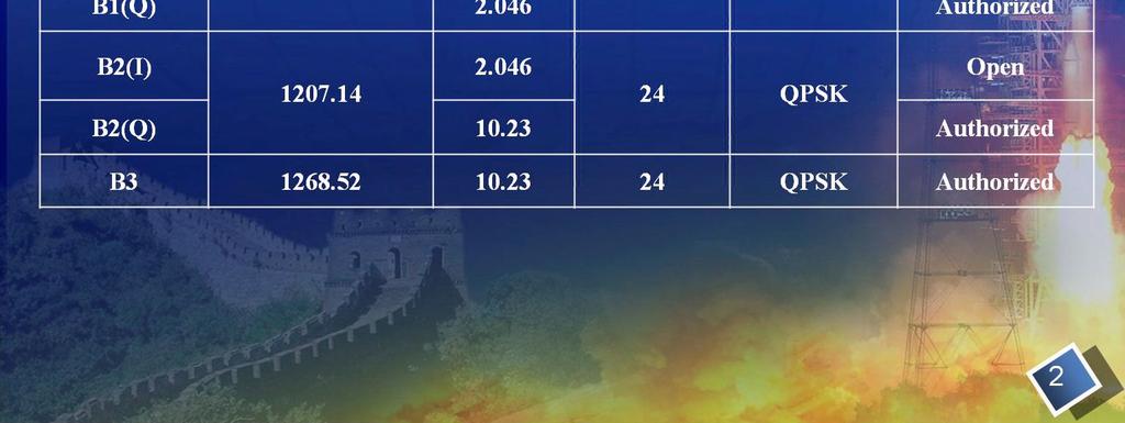
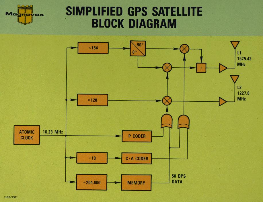
10 GPS Signals Summary Band Center Frequency Signal Waveform Notes C/A BPSK(1) Open Service L MHz P(Y) BPSK(10) L1C TMBOC Open Service, Separate Pilot and Data Channels M BOC(10,5) L MHz P(Y) BPSK(10) L2C BPSK(1) Open Service, Separate Pilot and Data Channels M BOC(10,5) L MHz L5 BPSK(10) Open Service, Separate Pilot and Data Channels Slide 7
11 Slide 8
12
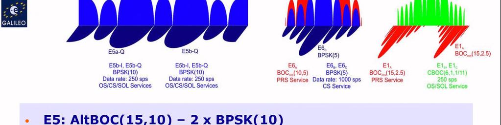
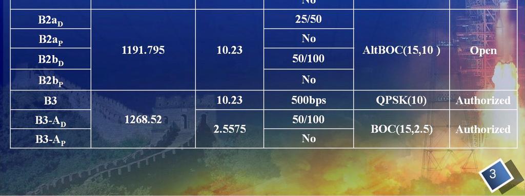
13 Galileo Signals Summary Band Center Frequency Signals Waveform Notes E MHz E1 OS CBOC Open Service, Separate Pilot and Data Channels PRS BOC(15,2.5) E MHz CS BPSK(5) Commercial Service, Separate Pilot and Data Channels PRS BOC(10,5) E MHz E5a & E5b AltBOC(15,10) Open Service, Separate Pilot and Data Channels Slide 10
14 Slide 11

15 Note: Some signal changes are being evaluated
16 Signal Plans Slide 13
17


18 Future GLONASS Signal Spectrum Slide 15
19 Signal Plans (From Several Presentations) Slide 16
20
21
22

23 QBOC
24 GNSS Signals, Spectra, and Receiver Fundamentals 1
25 2
26 3
27 Simple Pseudorandom Code Generator Code length = = = 15 C/A Code length = = =

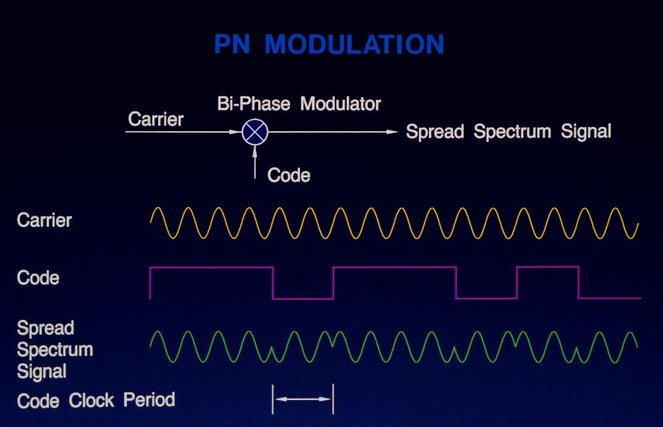
28 Code Modulation Spreads the Spectrum 5

29 Frequency Domain 6


30 GNSS Spectra E5b/B2b B3 E6 NAVIC Note: NAVIC L1, L2, & L5 are paramount, but also GLONASS, PRS, E5b, B3, & E6 7

")
31 GNSS L1 Spectrum Power Spectral Density (dbw/mhz) Frequency (MHz) 8
32 Receiver Signal Processing 9
33 10
34 27 Years with Just 3 GPS Signals Direct civil access to C/A code Indirect civil access by codeless and semi-codeless means 1978 to
35 IIR-M Satellites Added Three More Direct civil access to L2C code 1978 to

36 IIF Satellites Added L5 Safety service in ARNS band 1978 to

37 GPS III Will Add L1C Better performance 1978 to ? 14
38 Modernized Signal Structures The most important improvements in GNSS signal structures since1978 have been adopted for essentially every new and modernized signal Including GPS, Galileo, BeiDou, and QZSS Hopefully also for NAVIC and GLONASS CDMA The improvements are (a) to have a data-less pilot carrier and (b) to use Forward Error Control (FEC) to enhance data reception There are many other variations, e.g., Binary Offset Carrier (BOC) combinations, spreading code structures, FEC techniques, power split between data and pilot channels, symbol interleaving, etc. Each has a purpose, e.g., spectrum separation 15


39 Signal Structure, Interoperability, and Geometry Tom Stansell Consultant to the Aerospace Corporation 23 January 2018 ICG Workshop, Bangkok, Thailand The Aerospace Corporation 2015
40 Disclaimer The views and opinions expressed herein are those of the author and do not necessarily reflect the official policy or position of The Aerospace Corporation or of any agency of the U.S. government. Portions of this work have been sponsored by The Aerospace Corporation 2 The Aerospace Corporation 2015
41 The Most Important Ingredient Only Navigation by Satellite can provide excellent Geometry Continuous, worldwide, four dimensional, with excellent accuracy GDOP, Geometric Dilution of Precision, and its important children: PDOP, HDOP, VDOP, and TDOP Although the satellite signals may be weak, the geometry is strong No terrestrial navigation aid delivers the most important ingredient Do users need better geometry than GPS alone can provide? The answer is a definite YES as demonstrated by: Widespread use of GLONASS in products from consumer mobile phones to commercial survey and machine control products In spite of the difficulty of using GLONASS FDMA with GPS CDMA Plus widespread development of receivers to use all available GNSS Aircraft at altitude and ships at sea may not need more than GPS But integrity by A-RAIM requires many more satellites Users subject to signal blockage or outage do need more satellites Thus, the second most important ingredient is signal interoperability Enabling the best geometry by using every interoperable satellite signal 3 The Aerospace Corporation 2015
42 Signal Structure and Interoperability Considerations Interoperability is in the eye of the beholder For example, L1C and E1 OS have identical center frequencies and identical spectra, but almost everything else is different Spreading Code Length (chips) Spreading Code Duration Channel with BOC(6,1) Data Power Percent Pilot Power Percent Forward Error Correction Pilot Overlay Code Duration Receivers will handle the differences and hide them from the user The user will experience better performance due to more satellites However, different types of receivers will take advantage of some of the signal differences between systems Identical center frequency is important for high precision receivers and for bandwidth limited GNSS antennas on aircraft Many receivers will use GPS L1 C/A for fast signal acquisition but the other signal structures for navigation, positioning, and timing Message Frame Length Symbol Signal Modulation Rate Bit Rate L1C 10, ms TMBOC Pilot 25% 75% 100 SPS 50 BPS LDPC 18 sec 18 sec E1 OS 4,092 4 ms CBOC Both 50% 50% 250 SPS 125 BPS Convolutional 100 ms 720 sec 4 The Aerospace Corporation 2015
43 Predicting the Future If there are three global interoperable GNSS constellations in 2020 GPS, Galileo, and BeiDou, with a total of 72 to 90 operational satellites 1. Use of GLONASS FDMA will decrease for precision applications The current demand for more satellites will be satisfied by interoperable CDMA signals, leaving little demand for the more difficult FDMA signals 2. Users will not say this is my GNSS or this is my BeiDou There will be few if any GPS-only or BeiDou-only or Galileo-only receivers Users won t know and they won t care where the signals originate They will just enjoy the better performance provided by better geometry And they probably will continue to call their device a GPS (sorry!) 3. Special, unique, or orphan signals will be little used Use of GPS L2C will decline because no other GNSS provides it The standard dual-frequency pair will become and MHz E5b and B2b will be little used, whereas E5a and B2a will be widely used A lively discussion topic! 5 The Aerospace Corporation 2015
44 Future Decrease in High Precision FDMA Use A pure time delay Δt is characterized by a linear slope of phase versus frequency / f / ( / t) t However, a bandpass filter must rapidly attenuate signals outside the bandpass region This introduces nonlinearities in phase versus frequency, especially at the band edges In high precision applications it is desirable for every signal from every satellite to experience the same nonlinearities so there are no time delay differences between signals due to receiver filtering This will be true if every signal has the same center frequency Because this is not true for GLONASS FDMA signals, very careful calibration of each channel is required for near-precision results This is why high precision use of GLONASS FDMA will likely decrease substantially with deployment of Galileo and BeiDou Phase Frequency 6 The Aerospace Corporation 2015
45 Growth Continues and Should Accelerate Application growth is fueled primarily by the private sector Heavily regulated products, e.g., for aviation and the military, are slow to change and generally lag in innovation (sad but true) Factors that encourage innovation and application growth: Competition, Moore s law, opportunity, fear, and the profit motive What in the future will stimulate growth: Much better GNSS geometry improves availability, continuity, integrity, and accuracy, especially in difficult environments Urban canyons, real canyons, open pit mining, even aviation A-RAIM will become practical and begin to displace SBAS use Ambiguity resolution for Real Time Kinematic (RTK) in survey and machine control will become almost instantaneous and more reliable Improved vertical accuracy will displace some laser plane requirements Alternate means to communicate message parameters will promote instant navigation for all applications (push to navigate) 7 The Aerospace Corporation 2015
Future GNSS: Improved Signals and Constellations
 Future GNSS: Improved Signals and Constellations Guillermo Martínez Morán 1 1 Airbus Defense & Space. Paseo John Lennon s/n 28096 Getafe (Madrid Spain) Guillermo.M.Martinez@military.airbus.com Abstract:
Update on GPS L1C Signal Modernization. Tom Stansell Aerospace Consultant GPS Wing
 Update on GPS L1C Signal Modernization Tom Stansell Aerospace Consultant GPS Wing Glossary BOC = Binary Offset Carrier modulation C/A = GPS Coarse/Acquisition code dbw = 10 x log(signal Power/1 Watt) E1
Signal Structures for Satellite-Based Navigation: Past, Present, and Future*
 Signal Structures for Satellite-Based Navigation: Past, Present, and Future* John W. Betz 23 April 2013 *Approved for Public Release; Distribution Unlimited. 13-0908. The contents of this material reflect
GNSS Interoperability Enabling the Unknown Future
 GNSS Interoperability Enabling the Unknown Future Tom Stansell Consultant to The Aerospace Corporation Tom@Stansell.com CSNC 2014 Nanjing, China The Aerospace Corporation 2014 Disclaimer: The views and
Understanding GPS/GNSS
 Understanding GPS/GNSS Principles and Applications Third Edition Contents Preface to the Third Edition Third Edition Acknowledgments xix xxi CHAPTER 1 Introduction 1 1.1 Introduction 1 1.2 GNSS Overview
BeiDou Next Generation Signal Design and Expected Performance
 International Technical Symposium on Navigation and Timing ENAC, 17 Nov 2015 BeiDou Next Generation Signal Design and Expected Performance Challenges and Proposed Solutions Zheng Yao Tsinghua University
Future GNSS Precision Applications. Stuart Riley
 Future GNSS Precision Applications Stuart Riley Major Trimble Precision Markets Survey Mostly person portable equipment Construction Machine control and person carried equipment Includes Marine applications
Signal Quality Monitoring. Authors: Yury Yaskin, General Director, Chief designer. Valeriy Tyubalin, Deputy Chief designer
 Signal Quality Monitoring Authors: Yury Yaskin, General Director, Chief designer. Valeriy Tyubalin, Deputy Chief designer ICG-7 Meeting, Beijing, China, 4-9 November 2012 Avnues of development: 1. Controlling
NovAtel Precise Thinking Makes it Possible
 NovAtel Precise Thinking Makes it Possible Advantages of Multi-Frequency Multi-Constellation GNSS Thomas Morley, Product Manager Outline Who am I? What is GNSS? Where are we today with respect to GNSS?
Benefits and Limitations of New GNSS Signal Designs. Dr. A. J. Van Dierendonck AJ Systems, USA November 18, 2014
 Benefits and Limitations of New GNSS Signal Designs Dr. A. J. Van Dierendonck AJ Systems, USA November 18, 2014 My Opinions on New GNSS Signal Designs This briefing is loosely based upon Leadership Series
New Signal Structures for BeiDou Navigation Satellite System
 Stanford's 2014 PNT Symposium New Signal Structures for BeiDou Navigation Satellite System Mingquan Lu, Zheng Yao Tsinghua University 10/29/2014 1 Outline 1 Background and Motivation 2 Requirements and
CNES contribution to GALILEO signals design JC2. Jean-Luc Issler
 CNES contribution to GALILEO signals design JC2 Jean-Luc Issler INTRODUCTION GALILEO Signals have been designed by the members of the "GALILEO Signal Task Force(STF)" of the European Commission. CNES was
Understanding GPS: Principles and Applications Second Edition
 Understanding GPS: Principles and Applications Second Edition Elliott Kaplan and Christopher Hegarty ISBN 1-58053-894-0 Approx. 680 pages Navtech Part #1024 This thoroughly updated second edition of an
GNSS Modernisation and Its Effect on Surveying
 Lawrence LAU and Gethin ROBERTS, China/UK Key words: GNSS Modernisation, Multipath Effect SUMMARY GPS and GLONASS modernisation is being undertaken. The current GPS modernisation plan is expected to be
Satellite-based positioning (II)
") Lecture 11: TLT 5606 Spread Spectrum techniques Lecturer: Simona Lohan Satellite-based positioning (II) Outline GNSS navigation signals&spectra: description and details Basics: signal model, pilots, PRN
Lecture 11: TLT 5606 Spread Spectrum techniques Lecturer: Simona Lohan Satellite-based positioning (II) Outline GNSS navigation signals&spectra: description and details Basics: signal model, pilots, PRN
The report of Japan GNSS Interoperability Workshop. November 12th 2014 Quasi-Zenith Satellite System Services Inc.
 The report of Japan GNSS Interoperability Workshop November 12th 2014 Quasi-Zenith Satellite System Services Inc. Quasi-Zenith Satellite System Services Inc. 2014 Japan GNSS Interoperability Workshop Date
Where Next for GNSS?
 Where Next for GNSS? Professor Terry Moore Professor of Satellite Navigation Nottingham The University of Nottingham Where Next for GNSS Back to the Future? Professor Terry Moore Professor of Satellite
Assessment of GNSS Ionospheric Scintillation and TEC Monitoring Using the Multi-constellation GPStation-6 Receiver
 Assessment of GNSS Ionospheric Scintillation and TEC Monitoring Using the Multi-constellation GPStation-6 Receiver Rod MacLeod Regional Manager Asia/Pacific NovAtel Australia Pty Ltd Outline Ionospheric
Introduction to Global Navigation Satellite System (GNSS) Module: 1
 Module: 1") Introduction to Global Navigation Satellite System (GNSS) Module: 1 Dinesh Manandhar Center for Spatial Information Science The University of Tokyo Contact Information: dinesh@iis.u-tokyo.ac.jp Slide :
Introduction to Global Navigation Satellite System (GNSS) Module: 1 Dinesh Manandhar Center for Spatial Information Science The University of Tokyo Contact Information: dinesh@iis.u-tokyo.ac.jp Slide :
TEST YOUR SATELLITE NAVIGATION PERFORMANCE ON YOUR ANDROID DEVICE GLOSSARY
 TEST YOUR SATELLITE NAVIGATION PERFORMANCE ON YOUR ANDROID DEVICE GLOSSARY THE GLOSSARY This glossary aims to clarify and explain the acronyms used in GNSS and satellite navigation performance testing
Proceedings of Al-Azhar Engineering 7 th International Conference Cairo, April 7-10, 2003.
 Proceedings of Al-Azhar Engineering 7 th International Conference Cairo, April 7-10, 2003. MODERNIZATION PLAN OF GPS IN 21 st CENTURY AND ITS IMPACTS ON SURVEYING APPLICATIONS G. M. Dawod Survey Research
GPS and Recent Alternatives for Localisation. Dr. Thierry Peynot Australian Centre for Field Robotics The University of Sydney
 GPS and Recent Alternatives for Localisation Dr. Thierry Peynot Australian Centre for Field Robotics The University of Sydney Global Positioning System (GPS) All-weather and continuous signal system designed
GPS (Introduction) References. Terms
 References. Terms") GPS (Introduction) MSE, Rumc, GPS, 1 Terms NAVSTAR GPS ( Navigational Satellite Timing and Ranging - Global Positioning System) is a GNSS (Global Navigation Satellite System), developed by the US-DoD in
GPS (Introduction) MSE, Rumc, GPS, 1 Terms NAVSTAR GPS ( Navigational Satellite Timing and Ranging - Global Positioning System) is a GNSS (Global Navigation Satellite System), developed by the US-DoD in
Compact multi-gnss PPP corrections messages for transmission through a 250 bps channel
 Compact multi-gnss PPP corrections messages for transmission through a 250 bps channel Ken Harima, School of Science, RMIT University Suelynn Choy, School of Science, RMIT University Chris Rizos, School
DESIGN AND IMPLEMENTATION OF INTEGRATED GLOBAL NAVIGATION SATELLITE SYSTEM (GNSS) RECEIVER. B.Tech Thesis Report
 RECEIVER. B.Tech Thesis Report") Indian Institute of Technology Jodhpur DESIGN AND IMPLEMENTATION OF INTEGRATED GLOBAL NAVIGATION SATELLITE SYSTEM (GNSS) RECEIVER B.Tech Thesis Report Submitted by Arun Balajee V, Aswin Suresh and Mahesh
Indian Institute of Technology Jodhpur DESIGN AND IMPLEMENTATION OF INTEGRATED GLOBAL NAVIGATION SATELLITE SYSTEM (GNSS) RECEIVER B.Tech Thesis Report Submitted by Arun Balajee V, Aswin Suresh and Mahesh
Report of the Working Group B: Enhancement of Global Navigation Satellite Systems (GNSS) Services Performance
 Services Performance") Report of the Working Group B: Enhancement of Global Navigation Satellite Systems (GNSS) Services Performance 1. The Working Group on Enhancement of Global Navigation Satellite Systems (GNSS) Service Performance
Report of the Working Group B: Enhancement of Global Navigation Satellite Systems (GNSS) Services Performance 1. The Working Group on Enhancement of Global Navigation Satellite Systems (GNSS) Service Performance
King AbdulAziz University. Faculty of Environmental Design. Geomatics Department. Mobile GIS GEOM 427. Lecture 3
 King AbdulAziz University Faculty of Environmental Design Geomatics Department Mobile GIS GEOM 427 Lecture 3 Ahmed Baik, Ph.D. Email: abaik@kau.edu.sa Eng. Fisal Basheeh Email: fbasaheeh@kau.edu.sa GNSS
IMO WORLD-WIDE RADIONAVIGATION SYSTEM (WWRNS) GALILEO receiver performance standards. Submitted by the European Commission
 GALILEO receiver performance standards. Submitted by the European Commission") INTERNATIONAL MARITIME ORGANIZATION E IMO SUB-COMMITTEE ON SAFETY OF NAVIGATION 50th session Agenda item 13 2 April 2004 Original: ENGLISH WORLD-WIDE RADIONAVIGATION SYSTEM (WWRNS) GALILEO receiver performance
INTERNATIONAL MARITIME ORGANIZATION E IMO SUB-COMMITTEE ON SAFETY OF NAVIGATION 50th session Agenda item 13 2 April 2004 Original: ENGLISH WORLD-WIDE RADIONAVIGATION SYSTEM (WWRNS) GALILEO receiver performance
GPS Application. Global Positioning System. We provide GPS module ODM / OEM service, any GPS receiver you want, we can provide customized services.
 GPS Application Global Positioning System We provide GPS module ODM / OEM service, any GPS receiver you want, we can provide customized services. www.win-tec.com.tw sales@win-tec.com.tw GNSS Receiver WGM-303
DEFINING THE FUTURE OF SATELLITE SURVEYING WITH TRIMBLE R-TRACK TECHNOLOGY
 DEFINING THE FUTURE OF SATELLITE SURVEYING WITH TRIMBLE R-TRACK TECHNOLOGY EDMOND NORSE, GNSS PORTFOLIO MANAGER, TRIMBLE SURVEY DIVISION WESTMINSTER, CO USA ABSTRACT In September 2003 Trimble introduced
ICG GNSS Interoperability Workshop A Civil Aviation Perspective
 Approved for Public Release; Distribution Unlimited. 13-1907. ICG GNSS Interoperability Workshop A Civil Aviation Perspective C h r i s t o p h e r J. H e g a r t y A p r i l 2 0 1 3 Disclaimer: The contents
Webinar. 9 things you should know about centimeter-level GNSS accuracy
 Webinar 9 things you should know about centimeter-level GNSS accuracy Webinar agenda 9 things you should know about centimeter-level GNSS accuracy 1. High precision GNSS challenges 2. u-blox F9 technology
Errors in GPS. Errors in GPS. Geodetic Co-ordinate system. R. Khosla Fall Semester
 Errors in GPS Errors in GPS GPS is currently the most accurate positioning system available globally. Although we are talking about extreme precision and measuring distances by speed of light, yet there
GPS Modernization. The configuration of the GPS Space Segment is well-known. A minimum of 24 GPS
 1 GPS Modernization The configuration of the GPS Space Segment is well-known. A minimum of 24 GPS satellites ensure 24-hour worldwide coverage. But today there are more than that minimum on orbit. There
Effect of Quasi Zenith Satellite (QZS) on GPS Positioning
 on GPS Positioning") Effect of Quasi Zenith Satellite (QZS) on GPS ing Tomoji Takasu 1, Takuji Ebinuma 2, and Akio Yasuda 3 Laboratory of Satellite Navigation, Tokyo University of Marine Science and Technology 1 (Tel: +81-5245-7365,
Effect of Quasi Zenith Satellite (QZS) on GPS ing Tomoji Takasu 1, Takuji Ebinuma 2, and Akio Yasuda 3 Laboratory of Satellite Navigation, Tokyo University of Marine Science and Technology 1 (Tel: +81-5245-7365,
INTEGRITY AND CONTINUITY ANALYSIS FROM GPS JULY TO SEPTEMBER 2016 QUARTERLY REPORT
 INTEGRITY AND CONTINUITY ANALYSIS FROM GPS JULY TO SEPTEMBER 2016 QUARTERLY REPORT Name Responsibility Date Signature Prepared by M Pattinson (NSL) 07/10/16 Checked by L Banfield (NSL) 07/10/16 Authorised
Introduction to Global Navigation Satellite System (GNSS) Signal Structure
 Signal Structure") Introduction to Global Navigation Satellite System (GNSS) Signal Structure Dinesh Manandhar Center for Spatial Information Science The University of Tokyo Contact Information: dinesh@iis.u-tokyo.ac.jp
Introduction to Global Navigation Satellite System (GNSS) Signal Structure Dinesh Manandhar Center for Spatial Information Science The University of Tokyo Contact Information: dinesh@iis.u-tokyo.ac.jp
Integrity of Satellite Navigation in the Arctic
 Integrity of Satellite Navigation in the Arctic TODD WALTER & TYLER REID STANFORD UNIVERSITY APRIL 2018 Satellite Based Augmentation Systems (SBAS) in 2018 2 SBAS Networks in 2021? 3 What is Meant by Integrity?
GLOBAL NAVIGATION SATELLITE SYSTEMS (GNSS) ECE 2526E Tuesday, 24 April 2018
 ECE 2526E Tuesday, 24 April 2018") GLOBAL NAVIGATION SATELLITE SYSTEMS (GNSS) ECE 2526E Tuesday, 24 April 2018 MAJOR GLOBAL NAVIGATION SATELLITE SYSTEMS (GNSS) Global Navigation Satellite System (GNSS) includes: 1. Global Position System
GLOBAL NAVIGATION SATELLITE SYSTEMS (GNSS) ECE 2526E Tuesday, 24 April 2018 MAJOR GLOBAL NAVIGATION SATELLITE SYSTEMS (GNSS) Global Navigation Satellite System (GNSS) includes: 1. Global Position System
FieldGenius Technical Notes GPS Terminology
 FieldGenius Technical Notes GPS Terminology Almanac A set of Keplerian orbital parameters which allow the satellite positions to be predicted into the future. Ambiguity An integer value of the number of
Field experience with future GNSS ranging signals (a review). A.Simsky, J.-M. Sleewaegen, W. De Wilde Septentrio, Belgium
. A.Simsky, J.-M. Sleewaegen, W. De Wilde Septentrio, Belgium") Field experience with future GNSS ranging signals (a review). A.Simsky, J.-M. Sleewaegen, W. De Wilde Septentrio, Belgium Technical University of Munich June 07 2010 Contents Septentrio: company profile
Field experience with future GNSS ranging signals (a review). A.Simsky, J.-M. Sleewaegen, W. De Wilde Septentrio, Belgium Technical University of Munich June 07 2010 Contents Septentrio: company profile
Global Navigation Satellite System (GNSS) GPS Serves Over 400 Million Users Today. GPS is used throughout our society
 GPS Serves Over 400 Million Users Today. GPS is used throughout our society") Global avigation Satellite System (GSS) For freshmen at CKU AA December 10th, 2009 by Shau-Shiun Jan ICA & IAA, CKU Global avigation Satellite System (GSS) GSS (Global Positioning System, GPS) Basics Today
Global avigation Satellite System (GSS) For freshmen at CKU AA December 10th, 2009 by Shau-Shiun Jan ICA & IAA, CKU Global avigation Satellite System (GSS) GSS (Global Positioning System, GPS) Basics Today
Universal Acquisition and Tracking Apparatus for Global Navigation Satellite System (GNSS) Signals: Research Patent Introduction (RPI)
 Signals: Research Patent Introduction (RPI)") Universal Acquisition and Tracking Apparatus for Global Navigation Satellite System (GNSS) Signals: Research Patent Introduction (RPI) 27/01/2014 PAR R.JR. LANDRY, M.A. FORTIN ET J.C. GUAY 0 An RPI is
Universal Acquisition and Tracking Apparatus for Global Navigation Satellite System (GNSS) Signals: Research Patent Introduction (RPI) 27/01/2014 PAR R.JR. LANDRY, M.A. FORTIN ET J.C. GUAY 0 An RPI is
High Precision Applications with BeiDou
 High Precision Applications with BeiDou Lei HUANG Unicore Communications, Inc May 14, 2013 Contents 1 2 3 4 Background Overview of BeiDou high precision products Applications of BeiDou high precision products
GNSS Accuracy Improvements through Multipath Mitigation with New Signals and services
 GNSS Accuracy Improvements through Multipath Mitigation with New Signals and services Andrey Veytsel, Ph.D Moscow Technical University 10 Meeting of the International Committee on Global Navigation Satellite
GNSS Technologies. GNSS Acquisition Dr. Zahidul Bhuiyan Finnish Geospatial Research Institute, National Land Survey
 GNSS Acquisition 25.1.2016 Dr. Zahidul Bhuiyan Finnish Geospatial Research Institute, National Land Survey Content GNSS signal background Binary phase shift keying (BPSK) modulation Binary offset carrier
GPS for. Land Surveyors. Jan Van Sickle. Fourth Edition. CRC Press. Taylor & Francis Group. Taylor & Francis Croup, an Informa business
 GPS for Land Surveyors Fourth Edition Jan Van Sickle CRC Press Taylor & Francis Group Boca Raton London New York CRC Press is an imprint of the Taylor & Francis Croup, an Informa business Contents Preface
Signals, and Receivers
 ENGINEERING SATELLITE-BASED NAVIGATION AND TIMING Global Navigation Satellite Systems, Signals, and Receivers John W. Betz IEEE IEEE PRESS Wiley CONTENTS Preface Acknowledgments Useful Constants List of
RESOLUTION MSC.233(82) (adopted on 5 December 2006) ADOPTION OF THE PERFORMANCE STANDARDS FOR SHIPBORNE GALILEO RECEIVER EQUIPMENT
 (adopted on 5 December 2006) ADOPTION OF THE PERFORMANCE STANDARDS FOR SHIPBORNE GALILEO RECEIVER EQUIPMENT") MSC 82/24/Add.2 RESOLUTION MSC.233(82) THE MARITIME SAFETY COMMITTEE, RECALLING Article 28(b) of the Convention on the International Maritime Organization concerning the functions of the Committee, RECALLING
MSC 82/24/Add.2 RESOLUTION MSC.233(82) THE MARITIME SAFETY COMMITTEE, RECALLING Article 28(b) of the Convention on the International Maritime Organization concerning the functions of the Committee, RECALLING
A TSB business Support Solution Delivered through the Technology Programme
 1 Where to now with GNSS? Peter Lancaster Technology Translator Location & Timing KTN What is the Location & Timing KTN? Knowledge Transfer Networks are funded by the UK government, through the Technology
Benefits of combining systems The Receiver s Perspective Dr Philip G Mattos
 Benefits of combining systems The Receiver s Perspective Dr Philip G Mattos October 2011 Contents Who we are What s missing in GPS alone Other constellations available Improving GPS only receivers Add
Benefits of amulti-gnss Receiver inaninterference Environment
 Benefits of amulti-gnss Receiver inaninterference Environment Ulrich Engel Fraunhofer Institute for Communication, Information Processing and Ergonomics FKIE Department Sensor Data and Information Fusion
Sources of Error in Satellite Navigation Positioning
 http://www.transnav.eu the International Journal on Marine Navigation and Safety of Sea Transportation Volume 11 Number 3 September 2017 DOI: 10.12716/1001.11.03.04 Sources of Error in Satellite Navigation
Tracking New Signals from Space GPS Modernization and Trimble R-Track Technology
 Tracking New Signals from Space GPS Modernization and Trimble R-Track Technology Edmond T. Norse Trimble Integrated Surveying Group, Westminster, Colorado U.S. TRIMBLE 2 Tracking New Signals from Space
CHC MINING DEFORMATION MONITORING SOLUTION
 CHC MINING DEFORMATION MONITORING SOLUTION Safety is first in mining. CHC offers solutions designed to improve safety for personnel on the ground and in the cab with 24/7 precision positioning for automatic
Probability of Secondary Code Acquisition for Multi-Component GNSS Signals
 Author manuscript, published in "EWGNSS 23, 6th European Workshop on GNSS Signals and Signal Processing, Munich : Germany (23)" Probability of Secondary Code Acquisition for Multi-Component GNSS Signals
The Benefits of Three Frequencies for the High Accuracy Positioning
 The Benefits of Three Frequencies for the High Accuracy Positioning Nobuaki Kubo (Tokyo University of Marine and Science Technology) Akio Yasuda (Tokyo University of Marine and Science Technology) Isao
INTEGRITY AND CONTINUITY ANALYSIS FROM GPS JANUARY TO MARCH 2017 QUARTERLY REPORT
 INTEGRITY AND CONTINUITY ANALYSIS FROM GPS JANUARY TO MARCH 2017 QUARTERLY REPORT Name Responsibility Date Signature Prepared by M Pattinson (NSL) 11/04/17 Checked by L Banfield (NSL) 11/04/17 Authorised
Bernhard Hofnlann-Wellenhof Herbert Lichtenegger Elmar Wasle. GNSS - Global Navigation Satellite Systenls. GPS, GLONASS, Galileo, and nl0re
 Bernhard Hofnlann-Wellenhof Herbert Lichtenegger Elmar Wasle GNSS - Global Navigation Satellite Systenls GPS, GLONASS, Galileo, and nl0re SpringerWienNewYork Contents Abbreviations xxi 1 Introduction 1
Indian GNSS Industry Overview Challenges and future prospects
 Indian GNSS Industry Overview Challenges and future prospects Expert Presentation By Dr. S.V. Kibe Consultant, SATCOM & GNSS, Bangalore, India (Former Programme Director, SATNAV,ISRO HQ) On February 20,2013
GNSS Programme. Overview and Status in Europe
 GNSS Programme Overview and Status in Europe Inaugural Forum Satellite Positioning Research and Application Center 23 April 2007 Tokyo Presented by Thomas Naecke (European Commission) Prepared by Daniel
Fundamentals of GPS Navigation
 Fundamentals of GPS Navigation Kiril Alexiev 1 /76 2 /76 At the traditional January media briefing in Paris (January 18, 2017), European Space Agency (ESA) General Director Jan Woerner explained the knowns
What to Expect with the Current Constellation
 FIGURE 1 Galileo constellation and occupation status of orbital slots (RAAN: right ascension of the ascending node, May 9, 2017). Source: ESA HOW GALILEO BENEFITS HIGH-PRECISION RTK What to Expect with
Foreword by Glen Gibbons About this book Acknowledgments List of abbreviations and acronyms List of definitions
 Table of Foreword by Glen Gibbons About this book Acknowledgments List of abbreviations and acronyms List of definitions page xiii xix xx xxi xxv Part I GNSS: orbits, signals, and methods 1 GNSS ground
One Source for Positioning Success
 novatel.com One Source for Positioning Success RTK, PPP, SBAS OR DGNSS. NOVATEL CORRECT OPTIMIZES ALL CORRECTION SOURCES, PUTTING MORE POWER, FLEXIBILITY AND CONTROL IN YOUR HANDS. NovAtel CORRECT is the
Resection. We can measure direction in the real world! Lecture 10: Position Determination. Resection Example: Isola, Slovenia. Professor Keith Clarke
 Geography 12: Maps and Spatial Reasoning Lecture 10: Position Determination We can measure direction in the real world! Professor Keith Clarke Resection Resection Example: Isola, Slovenia Back azimuth
UPDATE ON GALILEO DEVELOPMENTS AND THE AVAILABLE SERVICES
 UPDATE ON GALILEO DEVELOPMENTS AND THE AVAILABLE SERVICES 3 rd EUPOS Council and Technical Meeting The third meeting of the Positioning Knowledge Exchange Network (PosKEN) Prague, The Czech Republic 14-16
The last 25 years - GPS to multi-gnss: from a military tool to the most widely used civilian positioning solution
 1 The last 25 years - GPS to multi-gnss: from a military tool to the most widely used civilian positioning solution B. Hofmann-Wellenhof Institute of Geodesy / Navigation, Graz University of Technology
GUIDANCE NOTES FOR GNSS NETWORK RTK SURVEYING IN GREAT BRITAIN
 GUIDANCE NOTES FOR GNSS NETWORK RTK SURVEYING IN GREAT BRITAIN ISSUE 4 MAY 2015 TSA Collaboration between: This leaflet has been produced to provide surveyors, engineers and their clients with guidelines
GPS/WAAS Program Update
 GPS/WAAS Program Update UN/Argentina Workshop on the Applications of GNSS 19-23 March 2018 Cordoba, Argentina GNSS: A Global Navigation Satellite System of Systems Global Constellations GPS (24+3) GLONASS
The Global Positioning System
 The Global Positioning System 5-1 US GPS Facts of Note DoD navigation system First launch on 22 Feb 1978, fully operational in 1994 ~$15 billion (?) invested to date 24 (+/-) Earth-orbiting satellites
GPS (Introduction) References. Terms
 References. Terms") GPS (Introduction) WCOM2, GPS, 1 Terms NAVSTAR GPS ( Navigational Satellite Timing and Ranging - Global Positioning System) is a GNSS (Global Navigation Satellite System), developed by the US-DoD in 197x
GPS (Introduction) WCOM2, GPS, 1 Terms NAVSTAR GPS ( Navigational Satellite Timing and Ranging - Global Positioning System) is a GNSS (Global Navigation Satellite System), developed by the US-DoD in 197x
Current status of Quasi-Zenith Satellite System. Japan Aerospace Exploration Agency QZSS Project Team
 Current status of Quasi-Zenith Satellite System Japan Aerospace Exploration Agency QZSS Project Team 1 Quasi-Zenith Satellite System The QZSS is a regional space-based PNT (Positioning, Navigation and
Monitoring the Ionosphere and Neutral Atmosphere with GPS
 Monitoring the Ionosphere and Neutral Atmosphere with GPS Richard B. Langley Geodetic Research Laboratory Department of Geodesy and Geomatics Engineering University of New Brunswick Fredericton, N.B. Division
GPS Milestones, cont. GPS Milestones. The Global Positioning Sytem, Part 1 10/10/2017. M. Helper, GEO 327G/386G, UT Austin 1. US GPS Facts of Note
 The Global Positioning System US GPS Facts of Note DoD navigation system First launch on 22 Feb 1978, fully operational in 1994 ~$15 billion (?) invested to date 24 (+/-) Earth-orbiting satellites (SVs)
Performance Evaluation of Differential Global Navigation Satellite System with RTK Corrections
 IOSR Journal of Electronics and Communication Engineering (IOSR-JECE) e-issn: 2278-2834,p- ISSN: 2278-8735.Volume 9, Issue 2, Ver. VI (Mar - Apr. 2014), PP 43-47 Performance Evaluation of Differential
Preparing for the Future The IGS in a Multi-GNSS World
 Preparing for the Future The IGS in a Multi-GNSS World O. Montenbruck DLR/GSOC 1 The International GNSS Service is a federation of more than 200 institutions and organizations worldwide a Service of the
ICG WG-B Achievements on Interoperable GNSS Space Service Volume (SSV) November, 2016 Sochi, Russian Federation
 November, 2016 Sochi, Russian Federation") ICG WG-B Achievements on Interoperable GNSS Space Service Volume (SSV) November, 2016 Sochi, Russian Federation ICG WG-B Action Group on SSV Action group on SSV was formed within WG-B in order to Establish
ICG WG-B Achievements on Interoperable GNSS Space Service Volume (SSV) November, 2016 Sochi, Russian Federation ICG WG-B Action Group on SSV Action group on SSV was formed within WG-B in order to Establish
The EU Satellite Navigation programmes status Applications for the CAP
 The EU Satellite Navigation programmes status Applications for the CAP Michaël MASTIER European Commission DG ENTR GP3 GNSS Applications, Security and International aspects GPS Workshop 2010 Montpellier
GE 113 REMOTE SENSING
 GE 113 REMOTE SENSING Topic 9. Introduction to Global Positioning Systems (GPS) and Other GNSS Technologies Lecturer: Engr. Jojene R. Santillan jrsantillan@carsu.edu.ph Division of Geodetic Engineering
BeiDou: Bring the World and China to Your Doorstep
 IGS Workshop 2012-ICG Working Group A BeiDou: Bring the World and China to Your Doorstep China Satellite Navigation Office 2012.7.25 Olsztyn, Poland 1 Contents I. Development Schemes II. Performance III.
Comprehensive Study of GNSS Systems
 Quest Journals Journal of Software Engineering and Simulation Volume 3 ~ Issue 2 (2016) pp: 01-06 ISSN(Online) :2321-3795 ISSN (Print):2321-3809 www.questjournals.org Research Paper Comprehensive Study
Testing of GNSS Dual-Frequency with Smartphones
 Testing of GNSS Dual-Frequency with Smartphones Towards better location performance in mass market applications P. Crosta, G. Galluzzo, R. Orus, R. Lucas, ESA J. Redelkiewicz, GSA ESA UNCLASSIFIED - For
GNSS analysis software GSILIB for utilizing Multi- GNSS data
 Technical Seminar Reference Frame in Practice, GNSS analysis software GSILIB for utilizing Multi- GNSS data *Satoshi Kawamoto, Naofumi Takamatsu Geospatial Information Authority of Japan Sponsors: Geospatial
Introduction to Advanced RAIM. Juan Blanch, Stanford University July 26, 2016
 Introduction to Advanced RAIM Juan Blanch, Stanford University July 26, 2016 Satellite-based Augmentation Systems Credit: Todd Walter Receiver Autonomous Integrity Monitoring (556 m Horizontal Error Bound)
Direct Comparison of the Multipath Performance of L1 BOC and C/A using On-Air Galileo and QZSS Transmissions
 Direct Comparison of the Multipath Performance of L BOC and C/A using On-Air Galileo and QZSS Transmissions Yu Hsuan Chen, Sherman Lo, Per Enge Department of Aeronautics & Astronautics Stanford University
Dynamic Reconfiguration in a GNSS Software Defined Radio for Multi-Constellation Operation
 Dynamic Reconfiguration in a GNSS Software Defined Radio for Multi-Constellation Operation Alison K. Brown and D Arlyn Reed, NAVSYS Corporation BIOGRAPHY Alison Brown is the President and Chief Executive
Developments in Satellite Navigation and Wireless Spectrum
 Developments in Satellite Navigation and Wireless Spectrum Chris Hegarty 14 June 2010 Christopher J. Hegarty, D.Sc. The MITRE Corporation chegarty@mitre.org 781-271-2127 (Tel) The contents of this material
2 INTRODUCTION TO GNSS REFLECTOMERY
 2 INTRODUCTION TO GNSS REFLECTOMERY 2.1 Introduction The use of Global Navigation Satellite Systems (GNSS) signals reflected by the sea surface for altimetry applications was first suggested by Martín-Neira
Lecture-1 CHAPTER 2 INTRODUCTION TO GPS
 Lecture-1 CHAPTER 2 INTRODUCTION TO GPS 2.1 History of GPS GPS is a global navigation satellite system (GNSS). It is the commonly used acronym of NAVSTAR (NAVigation System with Time And Ranging) GPS (Global
Demonstrations of Multi-Constellation Advanced RAIM for Vertical Guidance using GPS and GLONASS Signals
 Demonstrations of Multi-Constellation Advanced RAIM for Vertical Guidance using GPS and GLONASS Signals Myungjun Choi, Juan Blanch, Stanford University Dennis Akos, University of Colorado Boulder Liang
The Galileo signal in space (SiS)
") GNSS Solutions: Galileo Open Service and weak signal acquisition GNSS Solutions is a regular column featuring questions and answers about technical aspects of GNSS. Readers are invited to send their questions
GNSS Solutions: Galileo Open Service and weak signal acquisition GNSS Solutions is a regular column featuring questions and answers about technical aspects of GNSS. Readers are invited to send their questions
Delay Trackers for Galileo CBOC Modulated Signals and Their Simulink-based Implementations
 TAMPERE UNIVERSITY OF TECHNOLOGY Department of Communications Engineering ZHANG JIE Delay Trackers for Galileo CBOC Modulated Signals and Their Simulink-based Implementations Master of Science Thesis Subject
Study and Analysis on Binary Offset Carrier (BOC) Modulation in Satellite Navigation Systems
 Modulation in Satellite Navigation Systems") IOSR Journal of Electronics and Communication Engineering (IOSR-JECE) e-issn: 2278-2834,p- ISSN: 2278-8735.Volume 11, Issue 5, Ver. I (Sep.-Oct.2016), PP 115-123 www.iosrjournals.org Study and Analysis
IOSR Journal of Electronics and Communication Engineering (IOSR-JECE) e-issn: 2278-2834,p- ISSN: 2278-8735.Volume 11, Issue 5, Ver. I (Sep.-Oct.2016), PP 115-123 www.iosrjournals.org Study and Analysis
GLOBAL POSITIONING SYSTEM (GPS) PERFORMANCE APRIL TO JUNE 2017 QUARTERLY REPORT
 PERFORMANCE APRIL TO JUNE 2017 QUARTERLY REPORT") GLOBAL POSITIONING SYSTEM (GPS) PERFORMANCE APRIL TO JUNE 2017 QUARTERLY REPORT Name Responsibility Date Signature Prepared by M Pattinson (NSL) 06/07/17 Checked by L Banfield (NSL) 06/07/17 Authorised
GLOBAL POSITIONING SYSTEM (GPS) PERFORMANCE APRIL TO JUNE 2017 QUARTERLY REPORT Name Responsibility Date Signature Prepared by M Pattinson (NSL) 06/07/17 Checked by L Banfield (NSL) 06/07/17 Authorised
Global Positioning System: what it is and how we use it for measuring the earth s movement. May 5, 2009
 Global Positioning System: what it is and how we use it for measuring the earth s movement. May 5, 2009 References Lectures from K. Larson s Introduction to GNSS http://www.colorado.edu/engineering/asen/
GPS Adjacent Band Compatibility Assessment
 GPS Adjacent Band Compatibility Assessment Space-Based PNT Advisory Board Meeting May 18, 2016 EXCOM Co-Chair Letter to NTIA... without affecting existing and evolving uses of space-based PNT services
Design and Implementation of Global Navigation Satellite System (GNSS) Receiver. Final Presentation
 Receiver. Final Presentation") Design and Implementation of Global Navigation Satellite System (GNSS) Receiver Final Presentation Introduction Emerging applications of location based solutions automobiles, location based ads, emergency
Design and Implementation of Global Navigation Satellite System (GNSS) Receiver Final Presentation Introduction Emerging applications of location based solutions automobiles, location based ads, emergency
GLOBAL POSITIONING SYSTEM (GPS) PERFORMANCE JANUARY TO MARCH 2016 QUARTERLY REPORT
 PERFORMANCE JANUARY TO MARCH 2016 QUARTERLY REPORT") GLOBAL POSITIONING SYSTEM (GPS) PERFORMANCE JANUARY TO MARCH 2016 QUARTERLY REPORT Name Responsibility Date Signature Prepared by M Pattinson (NSL) 22/04/16 Checked by L Banfield (NSL) 22/04/16 Authorised
GLOBAL POSITIONING SYSTEM (GPS) PERFORMANCE JANUARY TO MARCH 2016 QUARTERLY REPORT Name Responsibility Date Signature Prepared by M Pattinson (NSL) 22/04/16 Checked by L Banfield (NSL) 22/04/16 Authorised
Satellite-Based Augmentation System (SBAS) Integrity Services
 Integrity Services") Satellite-Based Augmentation System (SBAS) Integrity Services Presented To: Munich, Germany Date: March 8, 2010 By: Leo Eldredge, Manager GNSS Group, FAA FAA Satellite Navigation Program 2 Wide Area Augmentation
Satellite-Based Augmentation System (SBAS) Integrity Services Presented To: Munich, Germany Date: March 8, 2010 By: Leo Eldredge, Manager GNSS Group, FAA FAA Satellite Navigation Program 2 Wide Area Augmentation