Alberding solutions for GNSS infrastructure operators
|
|
|
- Karin Bradley
- 6 years ago
- Views:
Transcription
1 Tamás Horváth Alberding solutions for GNSS infrastructure operators /35 Alberding solutions for GNSS infrastructure operators Tamás Horváth Alberding GmbH 4 th EUPOS Technical Meeting November 2017, Bratislava, Slovakia
2 Tamás Horváth Alberding solutions for GNSS infrastructure operators /35 Outline Alberding Ntrip Caster Alberding GNSS Status Software Correction service monitoring Alberding GNSS receivers
3 Tamás Horváth Alberding solutions for GNSS infrastructure operators /35 Alberding GmbH German GNSS software and hardware development company Based in Wildau (near Berlin) More than 20 years of experience in high-accuracy GNSS positioning Specialised in GNSS data communication, management, processing and monitoring Customised solutions for GNSS infrastructure operators and RTK service providers Independent from GNSS receiver manufacturers
4 Tamás Horváth Alberding solutions for GNSS infrastructure operators /35 Alberding Ntrip Caster Alberding GNSS Status Software Correction service monitoring Alberding GNSS receivers
5 Tamás Horváth Alberding solutions for GNSS infrastructure operators /35 Alberding Ntrip Caster Professional Ntrip Caster software for Linux OS Supports both Ntrip versions 1.0 and 2.0 Dirk Stöcker (Alberding GmbH) is chair of the RTCM SC-104 Internet Protocol WG: Ntrip standardisation Designed for mass usage can handle hundreds of reference stations (mountpoints) and thousands of simultaneous user connections minimal latency times, low system requirements
6 Tamás Horváth Alberding solutions for GNSS infrastructure operators /35 Alberding Ntrip Caster advantages Brand neutral solution no GNSS receiver priorities Separation of network RTK correction service from raw data provision to neighbouring countries, other service providers, etc. optimise licencing Scalable, easily expandable software Supports multiple ports and domain names (virtual casters) User NMEA position forwarding to 3 rd party Ntrip Casters Fault-tolerant architecture: backup Ntrip Caster

 Map display with fleet management functionality and rover quality control")
7 Tamás Horváth Alberding solutions for GNSS infrastructure operators /35 Alberding Ntrip Caster advantages Nearest base station auto-selection and auto-switch Web interface for system configuration, data and user management and monitoring Different levels of access to the web interface (admin, subadmin, basic) Map display with fleet management functionality and rover quality control SQL export of user connection information
8 Tamás Horváth Alberding solutions for GNSS infrastructure operators /35 Alberding Ntrip Caster Alberding GNSS Status Software Correction service monitoring Alberding GNSS receivers

 Data logging and redirection RINEX logging (v 2.11, v 3.")

9 Alberding GNSS Status Software Modular software for monitoring GNSS observation data quality Reference station antenna stability (post-processed PPP) DGNSS/RTK/PPP service quality External sensor data Troposphere (real-time PPP) Data logging and redirection RINEX logging (v 2.11, v 3.0x) Real-time data redirection (TCP, Ntrip) Web interface Visualisation Alarming Reporting Tamás Horváth Alberding solutions for GNSS infrastructure operators /35

 Statistical values External sensor data Weather station Tilt sensor Geotechnical sensors")
10 Tamás Horváth Alberding solutions for GNSS infrastructure operators /35 Alberding GNSS Status Software GNSS observation data quality Raw data availability, latency, completeness Number of satellites DOP values, skyplot Multipath Cycle slips Signal quality (C/N 0 ) Position quality Accuracy (N,E,H) Statistical values External sensor data Weather station Tilt sensor Geotechnical sensors Troposphere Zenith Total Delay Integrated Water Vapour

11 Tamás Horváth Alberding solutions for GNSS infrastructure operators /35 GNSS Status Software web interface The Surveying and Mapping Authority of the Republic of Slovenia

12 Tamás Horváth Alberding solutions for GNSS infrastructure operators /35 Observation data monitoring The Surveying and Mapping Authority of the Republic of Slovenia


13 Tamás Horváth Alberding solutions for GNSS infrastructure operators /35 Post-processed PPP monitoring Reference station coordinates Independent from the RTK networking algorithms Post processing of 24h RINEX files Web based status monitoring History data on time series plots Comparative analysis, differential plots Customisable alarm generation
")
 HUSKROUA/1101/252 \"Space Emergency System cross-border")
14 Tamás Horváth Alberding solutions for GNSS infrastructure operators /35 Troposphere monitoring Real-time Precise Point Positioning (PPP) based troposphere estimation Tropospheric Zenith Total Delay (ZTD) Integrated Water Vapour (IWV) HUSKROUA/1101/252 "Space Emergency System cross-border project


15 Tamás Horváth Alberding solutions for GNSS infrastructure operators /35 Troposphere monitoring ZTD and IWV time series plots Temperature and pressure differences HUSKROUA/1101/252 "Space Emergency System cross-border project


16 Tamás Horváth Alberding solutions for GNSS infrastructure operators /35 Troposphere monitoring Real-time ZTD, IWV, temperature and pressure surface maps HUSKROUA/1101/252 "Space Emergency System cross-border project
17 Tamás Horváth Alberding solutions for GNSS infrastructure operators /35 Alberding Ntrip Caster Alberding GNSS Status Software Correction service monitoring Alberding GNSS receivers


18 Tamás Horváth Alberding solutions for GNSS infrastructure operators /35 Alberding-QC service monitoring Quality control software for DGNSS, RTK and PPP service providers Multi-purpose tool: 3 modules integrated into a single web interface Monitors service availability, accuracy and data contents Software licence or service provided by Alberding GmbH


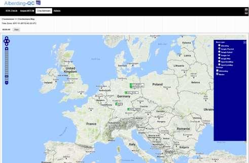
19 Alberding-QC software modules Checkstream Ntrip stream availability and data consistency RTK-Check Positioning accuracy and ambiguity fixing time InspectRTCM GNSS binary data decoding and visualisation Tamás Horváth Alberding solutions for GNSS infrastructure operators /35
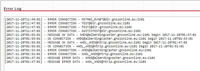
20 Tamás Horváth Alberding solutions for GNSS infrastructure operators /35 Checkstream Ntrip monitoring Ntrip stream availability and Ntrip Caster server accessibility monitoring Periodic connections and data sampling Data decoding - format verification (RTCM, CMR, raw binary data ) Data content analysis message types (incl. MSM, SSR) and update rates Data age analysis Monitoring multiple casters from a single website Monitoring hundreds of Ntrip mountpoints NMEA output for network RTK streams Availability statistics for 24/7 and normal working hours Automatic /sms warnings with flexible settings PDF reporting


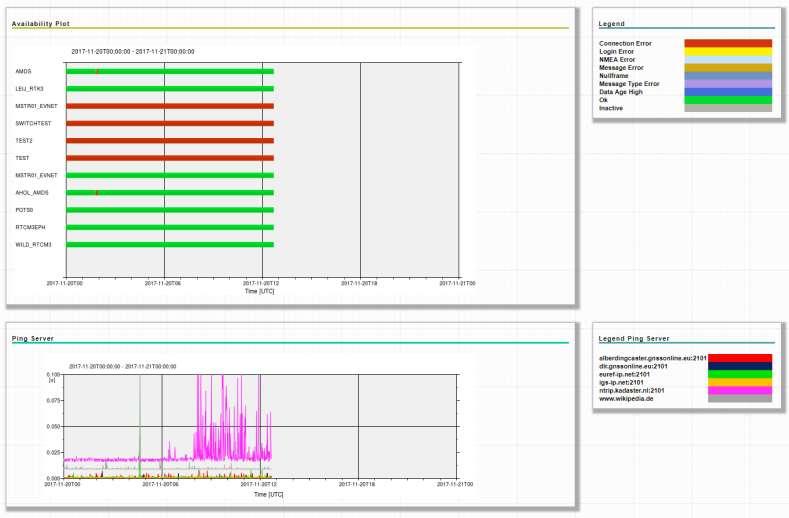
21 Tamás Horváth Alberding solutions for GNSS infrastructure operators /35 Checkstream web interface
 RTKLIB")

22 Tamás Horváth Alberding solutions for GNSS infrastructure operators /35 RTK-Check Positioning accuracy and RTK fixing time monitoring Physical monitor station receiver (fw solution) RTKLIB algorithms (sw solution) Periodic connection sessions Statistics generation Visualisation of the results warnings with customisable warning thresholds no NMEA data, no RTK Fix, high position error, low number of SVs, high data age Multiple position computations Supports RTCM 3.x incl. MSM and SSR PDF reports, CSV export Alberding A10


23 Tamás Horváth Alberding solutions for GNSS infrastructure operators /35 RTK-Check web interface


24 Tamás Horváth Alberding solutions for GNSS infrastructure operators /35 RTK-Check history data analysis
25 Tamás Horváth Alberding solutions for GNSS infrastructure operators /35 InspectRTCM GNSS binary data decoder software for detailed data content analysis RTCM binary InspectRTCM RTCM ASCII Real-time visualisation RTCM (incl. MSM, SSR, etc.), CMR, RTCA, raw binary input NMEA GGA output for network RTK streams Transmission delay analysis Data rate analysis of individual message types Real-time streams (TCP/UDP/Ntrip/serial) and file input

26 Tamás Horváth Alberding solutions for GNSS infrastructure operators /35 InspectRTCM web interface
27 Alberding DataConv Real-time GNSS data translation Raw data Leica Trimble Topcon Ashtech Septentrio Javad NovAtel Hemisphere GPS U-blox NVS etc. DataConv RTCM, CMR RINEX RTCM 2.x RTCM 3.x CMR CMR+ RINEX 2.11 RINEX 3.0x Tamás Horváth Alberding solutions for GNSS infrastructure operators /35
28 Alberding DataConv Real-time GNSS data translation Raw data DataConv RTCM, CMR RINEX RTCM DataConv CMR RINEX RTCA DataConv RTCM Tamás Horváth Alberding solutions for GNSS infrastructure operators /35
29 Tamás Horváth Alberding solutions for GNSS infrastructure operators /35 Alberding Ntrip Caster Alberding GNSS Status Software Correction service monitoring Alberding GNSS receivers
 Centimetre accuracy Integrated GPRS")
 for field data collection Applications: GIS /")
30 Tamás Horváth Alberding solutions for GNSS infrastructure operators /35 Alberding A07-RTK Low-cost L1 GNSS RTK receiver Multi-constellation (GPS, GLONASS, BeiDou) Centimetre accuracy Integrated GPRS modem, Bluetooth module Integrated processor for data management Data storage (32 GB memory card) RS232 serial port Li-Po battery Available in 2 different housings: A07-RTK Standard and A07-RTK Robust Alberding AGIS software (Android) for field data collection Applications: GIS / surveying, machine positioning, wireless data transfer, geo-monitoring


31 Tamás Horváth Alberding solutions for GNSS infrastructure operators /35 GIS data collection Effective geo data capture in the field Simple, lightweight and productive The A07-RTK receives corrections via Ntrip RTK position solution Position transmission via Bluetooth A07-RTK + AGIS Mapping Software Low-cost L1 GNSS multiconstellation receiver GIS field software for Android


32 Tamás Horváth Alberding solutions for GNSS infrastructure operators /35 Geo-monitoring with Alberding A07 A07-MON: GNSS measurements and telemetry On the server: automatic processing Sub-cm level displacement monitoring Alarming / SMS Visualisation of time series plots, PDF reports, CSV output


33 Tamás Horváth Alberding solutions for GNSS infrastructure operators /35 Alberding A10 Multi-constellation, dual-frequency RTK GNSS receiver with telemetry functionality Different compatible GNSS OEM boards Integrated 4G LTE modem Bluetooth module with antenna Cortex M3 processor with Alberding GNSS data management software 26-pin multi-port connector Embedded PC with Linux OS Applications: RTK surveying GNSS monitor station Machine auto-steering Service development and testing


34 Tamás Horváth Alberding solutions for GNSS infrastructure operators /35 Alberding A10 PPP-RTK test SAPOS SSR performance test in Germany SSR data generated and broadcast by SAPOS Bavaria SSR2OSR conversion on board A10 Geo++ SSR2OSR algorithm installed on the embedded Linux computer PPP-RTK position computation directly on the receiver
35 Tamás Horváth Alberding solutions for GNSS infrastructure operators /35 Thank you for your attention! Tamás Horváth Alberding GmbH Schmiedestraße 2 D Wildau Tel.: Mobile: horvath@alberding.eu Web:
Tamás Horváth. 06 June 2012
 Tamás Horváth Software solutions for GNSS infrastructure monitoring 06 June 2012 1/18 Software solutions for GNSS infrastructure monitoring Tamás Horváth Alberding GmbH 06 June 2012 Tamás Horváth Software
Monitoring with low-cost GNSS receivers
 Monitoring with low-cost GNSS receivers GNSS monitoring with low-cost receivers 1 Why GNSS? Your advantages! free of charge and available worldwide No line of sight connection is necessary to the measuring
al T TD ) ime D Faamily Products The RTD Family of products offers a full suite of highprecision GPS sensor positioning and navigation solutions for:
 ime D Faamily Products The RTD Family of products offers a full suite of highprecision GPS sensor positioning and navigation solutions for:") Reeal ynnamics al T amics (R TD ) ime D RTD) Time Dy Faamily mily ooff P roducts Products The RTD Family of products offers a full suite of highprecision GPS sensor positioning and navigation solutions
Reeal ynnamics al T amics (R TD ) ime D RTD) Time Dy Faamily mily ooff P roducts Products The RTD Family of products offers a full suite of highprecision GPS sensor positioning and navigation solutions
The role of EGNOS in the recapitalised DGNSS service of WSV - concept and implementation
 The role of EGNOS in the recapitalised DGNSS service of WSV - concept and implementation Tamás Horváth 1, Michael Hoppe 2 1 Alberding GmbH 2 German Federal Waterways and Shipping Administration (WSV) EGNOS
Leica Spider Infrastructure HW Solutions Introducing: Leica GR30 & GR50
 Leica Spider Infrastructure HW Solutions Introducing: Leica GR30 & GR50 Reliable solutions for today and tomorrow Leica Spider Integrated Solutions Introducing: Leica GR30 & GR50 Outline Introducing Leica
Trimble GPSNet 2.5 Software for GNSS Infrastructure: New Features. Martin Janousek - Trimble Technical Support - Infrastructure
 Trimble GPSNet 2.5 Software for GNSS Infrastructure: New Features Martin Janousek - Trimble Technical Support - Infrastructure GPSNet Users Seminar Munich, March 30 th /31 th 2006 Overview Support for
Towards a EUREF Service Providing Real-time GNSS Clock and Orbit Corrections
 Towards a EUREF Service Providing Real-time GNSS Clock and Orbit Corrections G. Weber 1), W. Söhne 1), A. Stürze 1), L. Mervart 2) 1) Federal Agency for Cartography and Geodesy, Frankfurt am Main, Germany
SSR & RTCM Current Status
 SSR & RTCM Current Status Gerhard Wübbena, Martin Schmitz, Jannes Wübbena Geo++ GmbH 30827 Garbsen, Germany www.geopp.de Outline RTCM SC104 WG s SSR Today SSR Formats SC104 RTCM-SSR Geo++ RTCM 4090 SSR
SLX-1 NG Multi-Application GNSS Receiver
 SLX-1 NG Multi-Application GNSS Receiver w w w.sa tla b g p s. c o m SLX-1 NG Multi-Application GNSS Receiver Designed for CORS Ready for Anything European Standards GPS GLONASS BEIDOU GALILEO SBAS QZSS
SSR Technology for Scalable Real-Time GNSS Applications
 SSR Technology for Scalable Real-Time GNSS Applications Gerhard Wübbena, Jannes Wübbena, Temmo Wübbena, Martin Schmitz Geo++ GmbH 30827 Garbsen, Germany www.geopp.de Abstract SSR Technology for scalable
Trimble GNSS Infrastructure
 Trimble GNSS Infrastructure A History of Innovation Trimble, the first company to offer commercial GPS products company to integrate GPS with communications technology RTK system in the market in 1994
European Position Determination System. Technical Standards
 European Position Determination System Technical Standards Revised 2 nd Edition 24 April 2008 Resolution of the International EUPOS Steering Committee 13 th Conference, Bucharest, Romania, 23 24 April
SUPPORT OF NETWORK FORMATS BY TRIMBLE GPSNET NETWORK RTK SOLUTION
 SUPPORT OF NETWORK FORMATS BY TRIMBLE GPSNET NETWORK RTK SOLUTION TRIMBLE TERRASAT GMBH, HARINGSTRASSE 19, 85635 HOEHENKIRCHEN, GERMANY STATUS The Trimble GPSNet network RTK solution was first introduced
EGNOS correction transmission via IALA beacons and AIS
 EGNOS correction transmission via IALA beacons and GSA SC24 pilot project results Tamás Horváth Alberding GmbH Danube Information Services Conference DISC 2018 12-13 December 2018, Bratislava, Slovakia
SLX-1 Multi-Application GNSS Receiver
 SLX-1 Multi-Application GNSS Receiver w w w.sa tla b g p s. c o m SLX-1 Multi-Application GNSS Receiver Designed for CORS Ready for Anything European Standards GPS GLONASS BEIDOU GALILEO SBAS QZSS Long
SL 300 GNSS Receiver. w w w.sa tla b g p s. c o m
 SL 300 GNSS Receiver w w w.sa tla b g p s. c o m SL 300 GNSS Receiver The Ultimate Expandable Handheld Smart GNSS Sensor with Multi Constellation Tracking European Standards Lightweight Bluetooth Multi
SKPOS. Slovak real-time positioning service - a multifunctional tool for precise object and phenomena positioning
 SKPOS Slovak real-time positioning service - a multifunctional tool for precise object and phenomena positioning WHAT IS SKPOS AND HOW DOES IT WORK? Slovak real-time positioning service is a multifunctional
NTRIP Background History, Development & BKG. Networked Transport of RTCM via Internet Protocol
 Networked Transport of RTCM via Internet Protocol Networked Transport of RTCM via Internet Protocol Bundesamt für Kartographie und Geodäsie Motivation: Use Internet to transport GNSS corrections Communication
Motion & Navigation Solution
 Navsight Land & Air Solution Motion & Navigation Solution FOR SURVEYING APPLICATIONS Motion, Navigation, and Geo-referencing NAVSIGHT LAND/AIR SOLUTION is a full high performance inertial navigation solution
MGA Webinar Series : 1 Very Cheap RTK Receivers: Changing the Landscape of Positioning Services
 MGA Webinar Series : 1 Very Cheap RTK Receivers: Changing the Landscape of Positioning Services Dinesh Manandhar Center for Spatial Information Science The University of Tokyo Contact Information: dinesh@iis.u-tokyo.ac.jp
SL 300 GNSS Receiver. w w w. s a t l a b g p s. c o m
 SL 300 GNSS Receiver w w w. s a t l a b g p s. c o m SL 300 6G GNSS Receiver The Ultimate Expandable Handheld Smart GNSS Sensor with 6G Tracking European Standards Lightweight Bluetooth GPS GLONASS BEIDOU
RELEASE NOTES. Introduction. Trimble Infrastructure GNSS Series Receivers
 RELEASE NOTES Trimble Infrastructure GNSS Series Receivers These release notes describe the latest improvements made to the Trimble NetR9 GNSS Infrastructure series receivers. Introduction New Features
Precise Positioning GNSS Applications
 Precise Point Positioning: Is the Era of Differential GNSS Positioning Drawing to an End? School of Surveying & Spatial Information Systems, UNSW, Sydney, Australia Chris Rizos 1, Volker Janssen 2, Craig
Leica GRX1200+ Series High Performance GNSS Reference Receivers
 Leica GRX1200+ Series High Performance GNSS Reference Receivers Leica GRX1200+ Series For permanent reference stations The Leica GRX1200+ Series, part of Leica's future proof System 1200, is designed specifically
Monitoring Lecture ETH Zürich, Michael Rutschmann
 Monitoring Lecture 5.11.2008 ETH Zürich, Michael Rutschmann Monitoring lecture Contents 1. Monitoring System Intro 2. Different Setup of Monitoring Systems 3. GeoMoS (Monitor and Analyzer) 4. Setup of
Guide to GNSS Base stations
 Guide to GNSS Base stations Outline Introduction Example of a base station (TUMSAT) Preparation for setting up a base station Procedure for setting up a base station Examples at two other universities
Article Number: 457 Rating: Unrated Last Updated: Wed, Sep 2, 2009 at 3:46 PM
 T opcon GB-1000 - Receiver Board Firmware Version 3.4 Article Number: 457 Rating: Unrated Last Updated: Wed, Sep 2, 2009 at 3:46 PM Topcon has recently released GNSS receiver board firmware version 3.4
Setting up i80 CHC receiver in RTK mode using TcpGPS
 Sumatra, 9 E-29190 Málaga (Spain) www.aplitop.com Phone: +34 952439771 Fax: +34 952431371 Technical Note (tcpgps_en_v41_002_setting_up_chc_i80_in_rtk_mode) Setting up i80 CHC receiver in RTK mode using
RELEASE NOTES. Introduction. Trimble NetR9 Infrastructure GNSS Series Receivers
 RELEASE NOTES Trimble NetR9 Infrastructure GNSS Series Receivers These release notes describe the latest improvements made to the Trimble Infrastructure GNSS series receivers. Introduction New Features
MAGICGNSS RTCM-BASED SERVICE, A LEAP FORWARD TOWARDS MULTI- GNSS HIGH ACCURACY REAL-TIME PROCESSING
 ION GNSS 2015 MAGICGNSS RTCM-BASED SERVICE, A LEAP FORWARD TOWARDS MULTI- GNSS HIGH ACCURACY REAL-TIME PROCESSING SEPTEMBER 16 TH, 2015 - ION GNSS 2015, TAMPA, FLORIDA, USA SESSION E2A: NEXT GENERATION
GNSS POST-PROCESSING SOFTWARE
 GNSS POST-PROCESSING SOFTWARE Product Overview // July 2018 EZSURV POST-PROCESSING SOFTWARE EZSurv software is designed to edit, process and analyze raw GNSS (Global Navigation Satellite System) data to
GNSS Low-Cost High-Accuracy Receiver (L-CHAR)
") GNSS Low-Cost High-Accuracy Receiver (L-CHAR) Dinesh Manandhar Center for Spatial Information Science The University of Tokyo Contact Information: dinesh@iis.u-tokyo.ac.jp Slide : 1 High Accuracy Receivers
GNSS Low-Cost High-Accuracy Receiver (L-CHAR) Dinesh Manandhar Center for Spatial Information Science The University of Tokyo Contact Information: dinesh@iis.u-tokyo.ac.jp Slide : 1 High Accuracy Receivers
SERVIR: The Portuguese Army CORS Network for RTK
 SERVIR: The Portuguese Army CORS Network for RTK António Jaime Gago AFONSO, Rui Francisco da Silva TEODORO and Virgílio Brito MENDES, Portugal Key words: GNSS, RTK, VRS, Network ABSTRACT Traditionally
GNSS POST-PROCESSING SOFTWARE
 GNSS POST-PROCESSING SOFTWARE Product Overview // June 2014 EZSURV POST-PROCESSING SOFTWARE EZSurv software is designed to edit, process and analyze raw GNSS (Global Navigation Satellite System) data to
EUPOS: Unified GNSS Augmentation Infrastructure and International Cooperation in Central and Eastern Europe
 EUPOS: Unified GNSS Augmentation Infrastructure and International Cooperation in Central and Eastern Europe Senate Department for Urban Development Geodetic Reference Systems Fehrbelliner Platz 1, 10707
Cross-Border EUPOS Data Exchange First Experience
 Cross-Border EUPOS Data Exchange First Experience Eimuntas Paršeliūnas, Marius Petniūnas, Domantas Bručas (Institute of Geodesy of Vilnius Gediminas Technical University, Lithuania) Wieslaw Graszka (Head
Leica GRX1200 Series High Performance GNSS Reference Receivers
 Leica GRX1200 Series High Performance GNSS Reference Receivers Leica GRX1200 Series For permanent reference stations The Leica GRX1200 Series, part of Leica s new System 1200, is designed specifically
PPP with Ambiguity Resolution (AR) using RTCM-SSR
 using RTCM-SSR") PPP with Ambiguity Resolution (AR) using RTCM-SSR Gerhard Wübbena, Martin Schmitz, Andreas Bagge Geo++ GmbH 30827 Garbsen Germany www.geopp.de PPP with Ambiguity Resolution (AR) using RTCM-SSR Abstract
PPP with Ambiguity Resolution (AR) using RTCM-SSR Gerhard Wübbena, Martin Schmitz, Andreas Bagge Geo++ GmbH 30827 Garbsen Germany www.geopp.de PPP with Ambiguity Resolution (AR) using RTCM-SSR Abstract
ProMark 3 RTK. White Paper
 ProMark 3 RTK White Paper Table of Contents 1. Introduction... 1 2. ProMark3 RTK Operational Environment... 2 3. BLADE TM : A Unique Magellan Technology for Quicker Convergence... 3 4. ProMark3 RTK Fixed
The Reasons to Succeed or to Fail a GNSS Network RTK Project
 The Reasons to Succeed or to Fail a GNSS Network RTK Project Joël van Cranenbroeck, Managing Director CGEOS Creative Geosensing sprl-s, Belgium Andy Yin, International Sales Director ComNav Technology
Trimble NetR9 Reference Receiver Series: Frequently Asked Questions
 July 2010 Trimble NetR9 Reference Receiver Series: Frequently Asked Questions What is the Trimble NetR9 GNSS reference receiver? The Trimble NetR9 GNSS (Global Navigation Satellite System) reference receiver
The new geo-fennel. FGS 1 GNSS Receiver
 The new geo-fennel FGS 1 GNSS Receiver 1 FGS 1 Unique GPS Set for multipurpose applications The geo-fennel FGS 1 is a robust receiver designed for challenging environments integrated into a compact device
The new geo-fennel. FGS 1 GNSS Receiver
 The new geo-fennel FGS 1 GNSS Receiver 1 FGS 1 Unique GPS Set for multipurpose applications The geo-fennel FGS 1 is a robust receiver designed for challenging environments integrated into a compact device
Inertial Navigation System
 Apogee Series ULTIMATE ACCURACY MEMS Inertial Navigation System INS MRU AHRS ITAR Free 0.005 RMS Motion Sensing & Georeferencing APOGEE SERIES makes high accuracy affordable for all surveying companies.
Real-time Stream Conversion to RTCM-3 MSM and RINEX-3 in IGS/MGEX Context
 Real-time Stream Conversion to RTCM-3 MSM and RINEX-3 in IGS/MGEX Context Georg Weber (BKG), Ken MacLeod (NRCan), Leos Mervart (CTU), Oliver Montenbruck (DLR), James Perlt (BKG), Dirk Stöcker (Alberding),
When do you expect Athena to be available for VS330? This is currently being beta-tested and will be released in the very near future.
 Why Athena? Athena GNSS Engine What improvements does Athena offer over the RTK firmware I m running now? Compared to the Hemisphere firmware most users are currently using (Qf4), there are significant
RTCM State Space Representation (SSR) Overall Concepts Towards PPP-RTK
 Overall Concepts Towards PPP-RTK") RTCM State Space Representation (SSR) Overall Concepts Towards PPP-RTK Gerhard Wübbena Geo++ GmbH 30827 Garbsen Germany www.geopp.de Contents Terms and Abbreviations RTCM-SSR Working Group GNSS Error Sources
RTCM State Space Representation (SSR) Overall Concepts Towards PPP-RTK Gerhard Wübbena Geo++ GmbH 30827 Garbsen Germany www.geopp.de Contents Terms and Abbreviations RTCM-SSR Working Group GNSS Error Sources
IMO WORLDWIDE RADIONAVIGATION SYSTEM (WWRNS) Study on Communication Techniques for High Accuracy DGPS in the Republic of Korea
 Study on Communication Techniques for High Accuracy DGPS in the Republic of Korea") INTERNATIONAL MARITIME ORGANIZATION E IMO SUB-COMMITTEE ON SAFETY OF NAVIGATION 52nd session Agenda item 12 NAV 52/INF.8 12 May 2006 ENGLISH ONLY WORLDWIDE RADIONAVIGATION SYSTEM (WWRNS) Study on Communication
INTERNATIONAL MARITIME ORGANIZATION E IMO SUB-COMMITTEE ON SAFETY OF NAVIGATION 52nd session Agenda item 12 NAV 52/INF.8 12 May 2006 ENGLISH ONLY WORLDWIDE RADIONAVIGATION SYSTEM (WWRNS) Study on Communication
A GLONASS Observation Message Compatible With The Compact Measurement Record Format
 A GLONASS Observation Message Compatible With The Compact Measurement Record Format Leica Geosystems AG 1 Introduction Real-time kinematic (RTK) Global Navigation Satellite System (GNSS) positioning has
Global Correction Services for GNSS
 Global Correction Services for GNSS Hemisphere GNSS Whitepaper September 5, 2015 Overview Since the early days of GPS, new industries emerged while existing industries evolved to use position data in real-time.
Skytraq Manual (Single frequency receiver) Procedure to logging skytraq data with RTKNAVI
 Procedure to logging skytraq data with RTKNAVI") Tokyo University of Marine Science and Technology Skytraq Manual (Single frequency receiver) Procedure to logging skytraq data with RTKNAVI TUMSAT 1 Skytraq Receiver http://www.skytraq.com.tw/products/products.html
Tokyo University of Marine Science and Technology Skytraq Manual (Single frequency receiver) Procedure to logging skytraq data with RTKNAVI TUMSAT 1 Skytraq Receiver http://www.skytraq.com.tw/products/products.html
Global and Regional Real-Time Infrastructure for open access use
 Global and Regional Real-Time Infrastructure for open access use Axel Rülke Federal Agency for Cartography and Geodesy Branch Office Leipzig, Germany Tutorial on (Open) Real-Time Infrastructure and Applications
The IGS Real-time Pilot Project
 The IGS Real-time Pilot Project The Development of Real-time IGS Correction Products for Precise Point Positioning Mark Caissy, Georg Weber, Loukis Agrotis, Gerhard Wübbena, and Manuel Hernández-Pajares
G10 G10 G10 LAND SURVEYING RTK GNSS SYSTEM RTK GNSS SYSTEM RTK GNSS SYSTEM. GENEQ inc. GNSS RTK measurement technology revolution
 GENEQ inc. S C I E N T I F I C I N S T R U M E N T S LAND SURVEYING RTK GNSS SYSTEM RTK GNSS SYSTEM RTK GNSS SYSTEM G10 G10 G10 The new generation full function GNSS Receiver GNSS RTK measurement technology
Specifications. Trimble BX982 Modular GNSS Heading Receiver
 Name Configuration Option Base and Rover interchangeability Rover position update rate Rover maximum range from base radio Rover operation within a VRS network Heading and Moving Base operation Factory
Performance Evaluation of Differential Global Navigation Satellite System with RTK Corrections
 IOSR Journal of Electronics and Communication Engineering (IOSR-JECE) e-issn: 2278-2834,p- ISSN: 2278-8735.Volume 9, Issue 2, Ver. VI (Mar - Apr. 2014), PP 43-47 Performance Evaluation of Differential
Receiver Technology CRESCENT OEM WHITE PAPER AMY DEWIS JENNIFER COLPITTS
 CRESCENT OEM WHITE PAPER AMY DEWIS JENNIFER COLPITTS With offices in Kansas City, Hiawatha, Calgary and Scottsdale, Hemisphere GPS is a global leader in designing and manufacturing innovative, costeffective,
Sokkia GNSS Receiver. Product Portfolio. Price GRX2 GCX2. GHX2 MESA Field Tablet SA300 S-10. Features
 Only from Sokkia GNSS Receiver Price Product Portfolio GRX2 GCX2 S-10 GHX2 MESA Field Tablet SA300 Features Product Overview Smallest and lightest GNSS integrated receiver Innovative and ergonomic shape
GeoMax GNSS Zenith10 & Zenith20 Series
 GeoMax GNSS Zenith10 & Zenith20 Series GeoMax About Us At GeoMax we provide a com- group with strong market At GeoMax, we concentrate on prehensive portfolio of inte- positions within measurement providing
Multi-GNSS real-time troposphere delay estimation
 Multi-GNSS real-time troposphere delay estimation Jaroslaw Bosy, Tomasz Hadas, Jak Kaplon, Kamil Kazmierski The 7th China Satellite Navigation Conference, May 18-20 Changsha China, Session S1: BDS/GNSS
ASG-EUPOS reference system
 Head Office of Geodesy and Cartography Department of Geodesy, Cartography and GIS ASG-EUPOS reference system Last year activities and future plans Szymon Wajda Prime specialist Bratislava, 21-22.11.2017
PosKEN Related Activities in the Czech Republic
 Research Institute of Geodesy, Topography, and Cartography Geodetic Observatory Pecny Land Survey Office, Prague PosKEN Related Activities in the Czech Republic 2014-2015 National Report J. Šimek 1 and
Facility. Development and Testing. What s Next? GNSS Modernization and Next Generation Hardware for the UNAVCO Community
 Facility Development and Testing What s Next? GNSS Modernization and Next Generation Hardware for the UNAVCO Community Frederick Blume UNAVCO Science Workshop, 9 March, 2010 Motivation Last formal hardware
Guide to GNSS Base stations
 Guide to GNSS Base stations Outline Introduction Example of Base Station (TUMSAT) Preparation for setting up a base station Procedure for setting up a base station Example of each Univ. Based on documents
The GNSS-CONTROL System has been designed in house by Position-Control and is the result of over 15 years experience using different Sensor Systems.
 GNSS Control BASE 1 Robust fanless GNSS System The GNSS-CONTROL System has been designed in house by Position-Control and is the result of over 15 years experience using different Sensor Systems. GNSS-CONTROL
NYSNET 11/28/2014 GPS/GLONASS (GG) January 2015 NYSAPLS Conference
 January 2015 NYSAPLS Conference") GPS/GLONASS (GG) January 2015 NYSAPLS Conference 2015 1 NYSNet 2015 GLONASS Upgrades Antenna Types Single Base/Network RTK GPS/GLONASS (GG) Single Base GPS/GLONASS (GG) Network RTK RT Products (NTRIP Mount
GPS/GLONASS (GG) January 2015 NYSAPLS Conference 2015 1 NYSNet 2015 GLONASS Upgrades Antenna Types Single Base/Network RTK GPS/GLONASS (GG) Single Base GPS/GLONASS (GG) Network RTK RT Products (NTRIP Mount
FieldGenius Technical Notes GPS Differential Corrections
 FieldGenius Technical tes GPS Differential Corrections Introduction The accuracy requirement of survey grade or mapping grade GPS applications for real time positioning requires the use of differential
New Guide to GNSS Base stations
 New Guide to GNSS Base stations Asian Base Stations Project Updated on December 2017 Outline 1 st Chapter (page3 page25) -Setting of The Base Station- Introduction Example of base Station (TUMSAT) Preparation
Real-Time and Multi-GNSS Key Projects of the International GNSS Service
 Real-Time and Multi-GNSS Key Projects of the International GNSS Service Urs Hugentobler, Chris Rizos, Mark Caissy, Georg Weber, Oliver Montenbruck, Ruth Neilan EUREF 2013 Symposium Budapest, Hungary, May
SETTOP M1 MULTIFUNCTION DEVICE ALL IN ONE GPS L1/L2/L5 3,5G USB
 SETTOP MULTIFUNCTION DEVICE ALL IN ONE GPS L1/L2/L5 Glonass 3,5G Router Wifi Memory Web Internet Radio Tx Rx COM Control Series Com Control USB Bluetooth Sensor Control Sensor Control Station COntrol GSM
Role of Manufacturers to support Geodetic Infrastructure
 FIG / UN-GGIM-AP / JUPEM Geospatial and GNSS CORS Infrastructure Forum Kuala Lumpur, Malaysia 16-17 Oct 2016 Role of Manufacturers to support Geodetic Infrastructure Neil Ashcroft Leica Geosystems Information
GNSS High Precision Systems for Cadastre: development, experiences and Galileo perspectives
 GNSS High Precision Systems for Cadastre: development, experiences and Galileo perspectives CLGE Plenary Workshop 29 September 2017 Roberto Capua, Flavio Ferrante DO-11-DO-03 1 Agenda GNSS High Precision
CHC i80 GNSS Receiver QuickTour with LandStar7. (PDA Network Mode)
") CHC i80 GNSS Receiver QuickTour with LandStar7 (PDA Network Mode) 1.Prerequisites Hardware: CHC i80 rover, Controller Kit, SIM card,lithium Battery, pole Software: LandStar7 2.Steps to set i80 working
CHC i80 GNSS Receiver QuickTour with LandStar7 (PDA Network Mode) 1.Prerequisites Hardware: CHC i80 rover, Controller Kit, SIM card,lithium Battery, pole Software: LandStar7 2.Steps to set i80 working
Quick Start. Tersus GNSS Center. Configuration Tools for Tersus GNSS RTK Systems.
 Quick Start Tersus GNSS Center Configuration Tools for Tersus GNSS RTK Systems www.tersus-gnss.com July, 2016 1. Quick Start Guide of Tersus GNSS Center This quick start guide provides the basic information
RELEASE NOTES. Trimble. SPS Series Receivers. Introduction. New features and changes
 RELEASE NOTES Trimble SPS Series Receivers Introduction New features and changes Version 4.42 Revision A June 2011 F Corporate office Trimble Navigation Limited Engineering and Construction group 5475
Evaluation of RTKLIB's Positioning Accuracy Using low-cost GNSS Receiver and ASG-EUPOS
 http://www.transnav.eu the International Journal on Marine Navigation and Safety of Sea Transportation Volume 7 Number 1 March 2013 DOI: 10.12716/1001.07.01.10 Evaluation of RTKLIB's Positioning Accuracy
Radio Navigation Laboratory (TOS-ETL) European Space Agency (ESA)
 European Space Agency (ESA)") Radio Navigation Laboratory (TOS-ETL) European Space Agency (ESA) Simon Johns (ESA) Michel Tossaint (ESA) Receiver Technical Workshop 3 rd July 2003 Paris 09/07/2003 1 Objectives of the Navigation Laboratory
Radio Navigation Laboratory (TOS-ETL) European Space Agency (ESA) Simon Johns (ESA) Michel Tossaint (ESA) Receiver Technical Workshop 3 rd July 2003 Paris 09/07/2003 1 Objectives of the Navigation Laboratory
EUPOS - European Position Determination System Status and current issues
 EUPOS - European Position Determination System Status and current issues Office of the International EUPOS Steering Committee Senate Department for Urban Development, Land Berlin, Germany Symposium of
RTCM-SSR Strategy of Bias Treatment
 RTCM-SSR Strategy of Bias Treatment Gerhard Wübbena Geo++ GmbH 30827 Garbsen Germany www.geopp.de Chair of RTCM-SSR WG www.rtcm.org RTCM-SC104 SSR Development working group established in 2007 3 message
EUPOS - EUROPEAN POSITION DETERMINATION SYSTEM INITIATIVE
 EUPOS - EUROPEAN POSITION DETERMINATION SYSTEM INITIATIVE Dr. Branislav Droščák EUPOS chairman & Geodetic and Cartographic institute Bratislava CLGE General Assembly March 22.-23. 2019. Sofia, Bulgaria
SETTOP M1 MULTIFUNCTION DEVICE MULTIFUNCTION GNSS THEINTERNET OFTHINGS GPS L1/L2/L5 3,5G USB 2017/09
 SETTOP MULTIFUNCTION DEVICE MULTIFUNCTION GNSS THEINTERNET OFTHINGS GPS L1/L2/L5 Glonass 3,5G Router Wifi Memory Web Internet Radio Tx Rx COM Control Series Com Control USB Bluetooth Sensor Control Sensor
Safety Information. CHC M6 GNSS Receiver. Revision 1.0 October 2017
 Safety Information il CHC M6 GNSS Receiver Revision 1.0 October 2017 Copyright Copyright 2016-2017 CHC Shanghai Huace Navigation Technology Ltd. All rights reserved. The CHC are trademark of Shanghai Huace
David GNSS Receiver Base & Rover Kits
 A ffordable Centimeter Precision for Everyone Base & Rover Kits METER Tersus The Tersus is a cost-efficient, palm-sized GNSS receiver designed for UAVs, AGVs, and surveying applica ons. Using an external
GPS Application. Global Positioning System. We provide GPS module ODM / OEM service, any GPS receiver you want, we can provide customized services.
 GPS Application Global Positioning System We provide GPS module ODM / OEM service, any GPS receiver you want, we can provide customized services. www.win-tec.com.tw sales@win-tec.com.tw GNSS Receiver WGM-303
PPS usable by timing applications via serial port emulation
 Timing & Navigation Module z051 USB GNSS Dongle with PPS* PPS usable by timing applications via serial port emulation * The Pulse Per Second (PPS) is an electrical signal that very precisely indicates
New Tools for Network RTK Integrity Monitoring
 New Tools for Network RTK Integrity Monitoring Xiaoming Chen, Herbert Landau, Ulrich Vollath Trimble Terrasat GmbH BIOGRAPHY Dr. Xiaoming Chen is a software engineer at Trimble Terrasat. He holds a PhD
Indian Institute of Technology Kanpur Department of Civil Engineering
 Indian Institute of Technology Kanpur Department of Civil Engineering Inquiry No- CE/JNM/2013-14/R-10 30 December, 2013 Subject: Quotation for supply of Integrated System/Smart System Reflectorless Robotic
MULTIFUNCTION GNSS SETTOP M1 MULTIFUNCTION DEVICE THEINTERNET OFTHINGS GPS L1/L2/L5 GLONASS WEB INTERNET MEMORY RADIO TX RX ROUTER WIFI 3,5G
 SETTOP MULTIFUNCTION DEVICE MULTIFUNCTION GNSS GPS L1/L2/L5 GLONASS 3,5G ROUTER WIFI MEMORY WEB INTERNET TX RX COM SERIES COM USB BLUETOOTH SENSOR SENSOR STATION 2018/09 GSM 3.5G GSM 3,5G SURVEY BASE APPLICATION
One Source for Positioning Success
 novatel.com One Source for Positioning Success RTK, PPP, SBAS OR DGNSS. NOVATEL CORRECT OPTIMIZES ALL CORRECTION SOURCES, PUTTING MORE POWER, FLEXIBILITY AND CONTROL IN YOUR HANDS. NovAtel CORRECT is the
The GNSS Active Control Point Concept Get the {dynamic} Reference Points when You Need
 The GNSS Active Control Point Concept Get the {dynamic} Reference Points when You Need Joel van Cranenbroeck Chair of Commission 6 WG 6.2 International Federation of Surveyors (FIG) Belgium, Europa 2 3
GNSS Receivers, Sensors, Desktop Solutions
 GNSS Receivers, Sensors, Desktop Solutions keep it simple high performance: the best GNSS tracking in field ready, reliable packages coupled with the best field and desktop software tools support and service
Leica GRX1200 Series Technical Data
 Leica GRX1200 Series Technical Data GRX1200 Series Technical Data Summary Description GRX1200 Lite GRX1200 Classic GRX1200 GG Pro Continuously Operating Reference Station (CORS) GPS GNSS Survey, geodetic,
A Novel Device for Autonomous Real-Time Precise Positioning with Global Coverage
 A Novel Device for Autonomous Real-Time Precise Positioning with Global Coverage D. Calle, P. Navarro, A. Mozo, R. Píriz, D. Rodríguez, G. Tobías. GMV, Spain BIOGRAPHY David Calle has a Master of Science
Accuracy Evaluation Internet-Based GNSS for Kinematic Surveying the Case Study in Thailand
 Accuracy Evaluation Internet-Based GNSS for Kinematic Surveying the Case Study in Thailand Kritsada Anantakarn 1 1 Faculty of Engineering and Architectural : Uthenthawai campus. Rajamongala University
Development of Multi-GNSS Orbit and Clock Determination Software "MADOCA"
 The 5th Asia Oceania Regional Workshop on GNSS Development of Multi-GNSS Orbit and Clock Determination Software "MADOCA" Tokyo Univ. of Marine Science and Technology Tomoji TAKASU December 1-3, 2013 @Hanoi
Overview and Setup Guide
 October 8, 2009. Application Note Page 1 of 10 Firmware 3.700 ALIGN Release With Y-Model Feature: 1 Introduction Overview and Setup Guide This application note provides an overview of the new ALIGN feature
Version 5.0 Release Notes
 Version 5.0 Release Notes Carlson Software, 2016 Table of Contents Improvements and Resolved Issues By Release 3 3 Improvements And Resolved Issues By Manufacturer 5 GNSS Receivers 5 Altus 6 Carlson 7
ALPHA RTK RECEIVER USER GUIDE
 ALPHA RECEIVER USER GUIDE Version 0.8 October 25, 2018 info@polaris-gnss.com https://www.polaris-gnss.com 1 Table of Contents 1. Overview... 3 1-1 Introduction... 3 1-2 Operation Guidelines... 3 1-3 Alpha
STRUCTURAL BRIDGE HEALTH MONITORING WITH GLONASS AND GPS THE YEONG-JONG BRIDGE IN SOUTH KOREA
 Joël VAN CRANENBROECK Leica Geosystems AG, Switzerland, joel.vancranenbroeck@leica-geosystems.com STRUCTURAL BRIDGE HEALTH MONITORING WITH GLONASS AND GPS THE YEONG-JONG BRIDGE IN SOUTH KOREA Key words:
Inertial Navigation System
 Apogee Marine Series ULTIMATE ACCURACY MEMS Inertial Navigation System INS MRU AHRS ITAR Free 0.005 RMS Navigation, Motion & Heave Sensing APOGEE SERIES makes high accuracy affordable for all surveying