NTRIP Background History, Development & BKG. Networked Transport of RTCM via Internet Protocol
|
|
|
- Caren Warner
- 5 years ago
- Views:
Transcription
1 Networked Transport of RTCM via Internet Protocol


2
3 Networked Transport of RTCM via Internet Protocol Bundesamt für Kartographie und Geodäsie
4 Motivation: Use Internet to transport GNSS corrections Communication satellite Radio link: AM, FM, VHF Mobile phone: GSM NTRIP Internet + Mobile Internet: GPRS Reference Rover
5 Motivation: Mass usage Server Splitter Caster Client 100+ x 10 kbit/s x 10 kbit/s


6 Motivation: Make GNSS corrections accessible to a wider user range GSM, GPRS, EDGE, UMTS,... RTCM - Standard any NTRIP - capable hardware - and software can be used
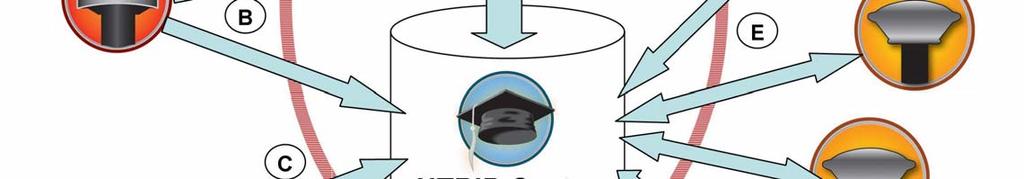
7 Motivation: Metadata
8 History Scientific Community: IGS-IP (Start: May 2006) - BKG operates (ports 80, 2101) - cooperate with RTIGS Working Group - offer world-wide data streams via NTRIP - following Open Data Policy - support RTCM 2.x, RTCM 3 and RTIGS data formats - Strategic Planning Meeting 8-9 Dec 2006
9
10 Radio Technical Commission for Maritime Services: Non-profit organisation ~ 100 members Develops industry standards for marine and land-based applications SC-104: Differential GNSS data formats RTCM 2.x and RTCM 3.0 data formats
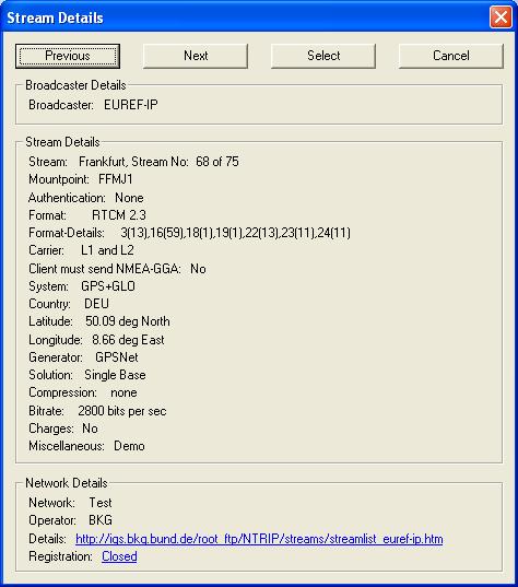
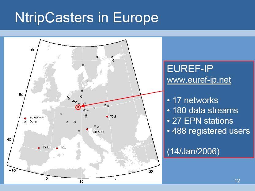
11 History Scientific Community: EUREF Symposium set up and maintain a differential GNSS infrastructure based on selected EPN stations through the Internet - upgrade respective EPN stations - enable real-time data stream dissemination - Broadcaster: (ports 80, 2101) EUREF Symposium Stream also carrier phase data
12 History Scientific Community: EUREF IP (Start: 2002) - Real-time access to reference frame - Disseminate real-time data from EPN stations - Develop NTRIP software tools (GPL) - Run network of NTRIP casters - Promote NTRIP technology - Enable generation of EUREF real-time products - Support scientific community in generating real-time products: Orbits & clocks Atmospheric parameters, disaster monitoring,...

13 NTRIP Streams Europe: June 2003

14 NTRIP Streams Europe: October 2006
15 World-wide NTRIP Streams: December 2003

16 World-wide NTRIP Streams: October 2006
17 Formats RTCM-SC104 Versions 2.0, 2.1, 2.2, 3.0 Type 1 Fixed GPS corrections (1 sec) Type 3 GPS reference station parameters (10) Type 16 GPS special message (30,60) Type 18 RTK uncorrected carrier phases (1) Type 19 RTK uncorrected pseudoranges (1) Type 22 Extended station parameters (15) Type 59 Proprietary messages (1) Raw Topcon/Javad Compact (1) Ashtech MBEN (5) / PBEN (5) / SNAV Thales ASCII SP3 ASCII Trimble RT17, concise Leica LB2 RINEX BINEX
18
19

20 INTERNET Central Processing Center NTRIP Caster Port 80 or 8080
 used to get user data from the caster Download a free client for testing, training (and correction relaying) from: http://igs.bkg.bund.")
21 NTRIP network Transportation of RTCM via Internet Protocol Server what sends data to a caster (CORS or RTN Software) Caster the exchange for incoming and outgoing data Client application(s) used to get user data from the caster Download a free client for testing, training (and correction relaying) from:
22
23 Stream Sharing Beyond RTN Tectonic Plate Studies Geodetic Monitoring Agencies / Services / Programs National CORS Program National / World Iono & Tropo Modeling National / World Timing Modeling / Studies National Positioning Initiatives (e.g. NDGPS, HaNDGPS) International Positioning Initiatives (IGS PPP) Augmentation Systems (WAAS, AGPS)

24 BKG NTRIP Client Downloads

25 BKG NTRIP Server Downloads

26 BKG Misc. Downloads

27 NTRIP Caster

28 NTRIP Caster


29 NTRIP Tools and Solutions Onboard Client and Server Applications
Towards a EUREF Service Providing Real-time GNSS Clock and Orbit Corrections
 Towards a EUREF Service Providing Real-time GNSS Clock and Orbit Corrections G. Weber 1), W. Söhne 1), A. Stürze 1), L. Mervart 2) 1) Federal Agency for Cartography and Geodesy, Frankfurt am Main, Germany
IMO WORLDWIDE RADIONAVIGATION SYSTEM (WWRNS) Study on Communication Techniques for High Accuracy DGPS in the Republic of Korea
 Study on Communication Techniques for High Accuracy DGPS in the Republic of Korea") INTERNATIONAL MARITIME ORGANIZATION E IMO SUB-COMMITTEE ON SAFETY OF NAVIGATION 52nd session Agenda item 12 NAV 52/INF.8 12 May 2006 ENGLISH ONLY WORLDWIDE RADIONAVIGATION SYSTEM (WWRNS) Study on Communication
INTERNATIONAL MARITIME ORGANIZATION E IMO SUB-COMMITTEE ON SAFETY OF NAVIGATION 52nd session Agenda item 12 NAV 52/INF.8 12 May 2006 ENGLISH ONLY WORLDWIDE RADIONAVIGATION SYSTEM (WWRNS) Study on Communication
Tamás Horváth. 06 June 2012
 Tamás Horváth Software solutions for GNSS infrastructure monitoring 06 June 2012 1/18 Software solutions for GNSS infrastructure monitoring Tamás Horváth Alberding GmbH 06 June 2012 Tamás Horváth Software
Real-Time GNSS EUREF-IP Pilot Project
 Real-Time GNSS EUREF-IP Pilot Project G. Weber, BKG, Frankfurt 1. Status: Network, coverage, contributors 2. White Paper: Real-time GNSS in Routine EPN Operations 3. Real-time GNSS tools: BNC, client for
Global and Regional Real-Time Infrastructure for open access use
 Global and Regional Real-Time Infrastructure for open access use Axel Rülke Federal Agency for Cartography and Geodesy Branch Office Leipzig, Germany Tutorial on (Open) Real-Time Infrastructure and Applications
EUPOS: Unified GNSS Augmentation Infrastructure and International Cooperation in Central and Eastern Europe
 EUPOS: Unified GNSS Augmentation Infrastructure and International Cooperation in Central and Eastern Europe Senate Department for Urban Development Geodetic Reference Systems Fehrbelliner Platz 1, 10707
Leica Spider Infrastructure HW Solutions Introducing: Leica GR30 & GR50
 Leica Spider Infrastructure HW Solutions Introducing: Leica GR30 & GR50 Reliable solutions for today and tomorrow Leica Spider Integrated Solutions Introducing: Leica GR30 & GR50 Outline Introducing Leica
Precise Positioning GNSS Applications
 Precise Point Positioning: Is the Era of Differential GNSS Positioning Drawing to an End? School of Surveying & Spatial Information Systems, UNSW, Sydney, Australia Chris Rizos 1, Volker Janssen 2, Craig
Trimble GPSNet 2.5 Software for GNSS Infrastructure: New Features. Martin Janousek - Trimble Technical Support - Infrastructure
 Trimble GPSNet 2.5 Software for GNSS Infrastructure: New Features Martin Janousek - Trimble Technical Support - Infrastructure GPSNet Users Seminar Munich, March 30 th /31 th 2006 Overview Support for
FieldGenius Technical Notes GPS Differential Corrections
 FieldGenius Technical tes GPS Differential Corrections Introduction The accuracy requirement of survey grade or mapping grade GPS applications for real time positioning requires the use of differential
Cross-Border EUPOS Data Exchange First Experience
 Cross-Border EUPOS Data Exchange First Experience Eimuntas Paršeliūnas, Marius Petniūnas, Domantas Bručas (Institute of Geodesy of Vilnius Gediminas Technical University, Lithuania) Wieslaw Graszka (Head
Leica GRX1200+ Series High Performance GNSS Reference Receivers
 Leica GRX1200+ Series High Performance GNSS Reference Receivers Leica GRX1200+ Series For permanent reference stations The Leica GRX1200+ Series, part of Leica's future proof System 1200, is designed specifically
Alberding solutions for GNSS infrastructure operators
 Tamás Horváth Alberding solutions for GNSS infrastructure operators 21.11.2017 1/35 Alberding solutions for GNSS infrastructure operators Tamás Horváth Alberding GmbH 4 th EUPOS Technical Meeting 21-22
SERVIR: The Portuguese Army CORS Network for RTK
 SERVIR: The Portuguese Army CORS Network for RTK António Jaime Gago AFONSO, Rui Francisco da Silva TEODORO and Virgílio Brito MENDES, Portugal Key words: GNSS, RTK, VRS, Network ABSTRACT Traditionally
Leica GRX1200 Series High Performance GNSS Reference Receivers
 Leica GRX1200 Series High Performance GNSS Reference Receivers Leica GRX1200 Series For permanent reference stations The Leica GRX1200 Series, part of Leica s new System 1200, is designed specifically
Trimble GNSS Infrastructure
 Trimble GNSS Infrastructure A History of Innovation Trimble, the first company to offer commercial GPS products company to integrate GPS with communications technology RTK system in the market in 1994
Performance Evaluation Of Real Time Precise Point Positioning (RT-PPP) In Static & Kinematic Modes In Egypt
 In Static & Kinematic Modes In Egypt") Performance Evaluation Of Real Time Precise Point Positioning (RT-PPP) In Static & Kinematic Modes In Egypt Eng. Ahmed Mansour Abdallah Dr. Mahmoud Abd Rabbou Prof. Adel El.shazly Geomatic Branch, Civil
Performance Evaluation Of Real Time Precise Point Positioning (RT-PPP) In Static & Kinematic Modes In Egypt Eng. Ahmed Mansour Abdallah Dr. Mahmoud Abd Rabbou Prof. Adel El.shazly Geomatic Branch, Civil
European Position Determination System. Technical Standards
 European Position Determination System Technical Standards Revised 2 nd Edition 24 April 2008 Resolution of the International EUPOS Steering Committee 13 th Conference, Bucharest, Romania, 23 24 April
PosKEN Related Activities in the Czech Republic
 Research Institute of Geodesy, Topography, and Cartography Geodetic Observatory Pecny Land Survey Office, Prague PosKEN Related Activities in the Czech Republic 2014-2015 National Report J. Šimek 1 and
Setting up i80 CHC receiver in RTK mode using TcpGPS
 Sumatra, 9 E-29190 Málaga (Spain) www.aplitop.com Phone: +34 952439771 Fax: +34 952431371 Technical Note (tcpgps_en_v41_002_setting_up_chc_i80_in_rtk_mode) Setting up i80 CHC receiver in RTK mode using
The IGS Real-time Pilot Project
 The IGS Real-time Pilot Project The Development of Real-time IGS Correction Products for Precise Point Positioning Mark Caissy, Georg Weber, Loukis Agrotis, Gerhard Wübbena, and Manuel Hernández-Pajares
The Usefulness of Internet-based (NTrip) RTK for Navigation and Intelligent Transportation Systems
 RTK for Navigation and Intelligent Transportation Systems") The Usefulness of Internet-based (NTrip) RTK for Navigation and Intelligent Transportation Systems Marcin Uradzinski, University of Warmia and Mazury, Poland Don Kim and Richard B. Langley, University
The Usefulness of Internet-based (NTrip) RTK for Navigation and Intelligent Transportation Systems Marcin Uradzinski, University of Warmia and Mazury, Poland Don Kim and Richard B. Langley, University
Real-Time and Multi-GNSS Key Projects of the International GNSS Service
 Real-Time and Multi-GNSS Key Projects of the International GNSS Service Urs Hugentobler, Chris Rizos, Mark Caissy, Georg Weber, Oliver Montenbruck, Ruth Neilan EUREF 2013 Symposium Budapest, Hungary, May
al T TD ) ime D Faamily Products The RTD Family of products offers a full suite of highprecision GPS sensor positioning and navigation solutions for:
 ime D Faamily Products The RTD Family of products offers a full suite of highprecision GPS sensor positioning and navigation solutions for:") Reeal ynnamics al T amics (R TD ) ime D RTD) Time Dy Faamily mily ooff P roducts Products The RTD Family of products offers a full suite of highprecision GPS sensor positioning and navigation solutions
Reeal ynnamics al T amics (R TD ) ime D RTD) Time Dy Faamily mily ooff P roducts Products The RTD Family of products offers a full suite of highprecision GPS sensor positioning and navigation solutions
Guide to GNSS Base stations
 Guide to GNSS Base stations Outline Introduction Example of a base station (TUMSAT) Preparation for setting up a base station Procedure for setting up a base station Examples at two other universities
The International Scene: How Precise Positioning Will Underpin Critical GNSS Applications
 The International Scene: How Precise Positioning Will Underpin Critical GNSS Applications School of Civil & Environmental Engineering, UNSW, Sydney, Australia Chris Rizos Member of the IGS Governing Board
NYSNET 11/28/2014 GPS/GLONASS (GG) January 2015 NYSAPLS Conference
 January 2015 NYSAPLS Conference") GPS/GLONASS (GG) January 2015 NYSAPLS Conference 2015 1 NYSNet 2015 GLONASS Upgrades Antenna Types Single Base/Network RTK GPS/GLONASS (GG) Single Base GPS/GLONASS (GG) Network RTK RT Products (NTRIP Mount
GPS/GLONASS (GG) January 2015 NYSAPLS Conference 2015 1 NYSNet 2015 GLONASS Upgrades Antenna Types Single Base/Network RTK GPS/GLONASS (GG) Single Base GPS/GLONASS (GG) Network RTK RT Products (NTRIP Mount
Skytraq Manual (Single frequency receiver) Procedure to logging skytraq data with RTKNAVI
 Procedure to logging skytraq data with RTKNAVI") Tokyo University of Marine Science and Technology Skytraq Manual (Single frequency receiver) Procedure to logging skytraq data with RTKNAVI TUMSAT 1 Skytraq Receiver http://www.skytraq.com.tw/products/products.html
Tokyo University of Marine Science and Technology Skytraq Manual (Single frequency receiver) Procedure to logging skytraq data with RTKNAVI TUMSAT 1 Skytraq Receiver http://www.skytraq.com.tw/products/products.html
FIELD TEST OF THE GPS+GLONASS RTK AT THE CAGLIARI PERMANENT STATION VIA INTERNET. Giannina Sanna, Giuseppina Vacca
 FIELD TEST OF THE GPS+GLONASS RTK AT THE CAGLIARI PERMANENT STATION VIA INTERNET Giannina Sanna, Giuseppina Vacca University of Cagliari Department of Structural Engineering P.zza D Armi 913 Cagliari,
MGA Webinar Series : 1 Very Cheap RTK Receivers: Changing the Landscape of Positioning Services
 MGA Webinar Series : 1 Very Cheap RTK Receivers: Changing the Landscape of Positioning Services Dinesh Manandhar Center for Spatial Information Science The University of Tokyo Contact Information: dinesh@iis.u-tokyo.ac.jp
Possibility of precise positioning and precise inshore navigation using RTK and Internet
 Possibility of precise positioning and precise inshore navigation using RTK and Internet. Kujawa & J. Rogowski Warsaw University of Technology, Warsaw, Poland ASTRACT: The practical need for GNSS positioning
Development of Multi-GNSS Orbit and Clock Determination Software "MADOCA"
 The 5th Asia Oceania Regional Workshop on GNSS Development of Multi-GNSS Orbit and Clock Determination Software "MADOCA" Tokyo Univ. of Marine Science and Technology Tomoji TAKASU December 1-3, 2013 @Hanoi
Positioning Techniques. João F. Galera Monico - UNESP Tuesday 12 Sep
 Positioning Techniques João F. Galera Monico - UNESP Tuesday 12 Sep Positioning methods Absolute Positioning Static and kinematic SPP and PPP Relative Positioning Static Static rapid Semi kinematic Kinematic
Comparative analysis of GNSS Real Time Kinematic methods for navigation
 IAV Hassan II Comparative analysis of GNSS Real Time Kinematic methods for navigation Mourad BOUZIANI School of Geomatic Sciences, IAV Hassan II, Rabat, Morocco. Coordinator of the Master - GNSS, IAV&
Compact multi-gnss PPP corrections messages for transmission through a 250 bps channel
 Compact multi-gnss PPP corrections messages for transmission through a 250 bps channel Ken Harima, School of Science, RMIT University Suelynn Choy, School of Science, RMIT University Chris Rizos, School
SSR Technology for Scalable Real-Time GNSS Applications
 SSR Technology for Scalable Real-Time GNSS Applications Gerhard Wübbena, Jannes Wübbena, Temmo Wübbena, Martin Schmitz Geo++ GmbH 30827 Garbsen, Germany www.geopp.de Abstract SSR Technology for scalable
Real-time Stream Conversion to RTCM-3 MSM and RINEX-3 in IGS/MGEX Context
 Real-time Stream Conversion to RTCM-3 MSM and RINEX-3 in IGS/MGEX Context Georg Weber (BKG), Ken MacLeod (NRCan), Leos Mervart (CTU), Oliver Montenbruck (DLR), James Perlt (BKG), Dirk Stöcker (Alberding),
RELEASE NOTES. Introduction. Trimble NetR9 Infrastructure GNSS Series Receivers
 RELEASE NOTES Trimble NetR9 Infrastructure GNSS Series Receivers These release notes describe the latest improvements made to the Trimble Infrastructure GNSS series receivers. Introduction New Features
SUPPORT OF NETWORK FORMATS BY TRIMBLE GPSNET NETWORK RTK SOLUTION
 SUPPORT OF NETWORK FORMATS BY TRIMBLE GPSNET NETWORK RTK SOLUTION TRIMBLE TERRASAT GMBH, HARINGSTRASSE 19, 85635 HOEHENKIRCHEN, GERMANY STATUS The Trimble GPSNet network RTK solution was first introduced
SKPOS. Slovak real-time positioning service - a multifunctional tool for precise object and phenomena positioning
 SKPOS Slovak real-time positioning service - a multifunctional tool for precise object and phenomena positioning WHAT IS SKPOS AND HOW DOES IT WORK? Slovak real-time positioning service is a multifunctional
EUPOS - European Position Determination System Status and current issues
 EUPOS - European Position Determination System Status and current issues Office of the International EUPOS Steering Committee Senate Department for Urban Development, Land Berlin, Germany Symposium of
Real-time RTK messages for permanent reference station applications standardized by RTCM. Dr.-Ing. Hans-Juergen Euler Leica Research Fellow
 Real-time RTK messages for permanent reference station applications standardized by RTCM Dr.-Ing. Hans-Juergen Euler Leica Research Fellow Permanent Station Arrays Arrays with Permanent Stations are established
SLX-1 Multi-Application GNSS Receiver
 SLX-1 Multi-Application GNSS Receiver w w w.sa tla b g p s. c o m SLX-1 Multi-Application GNSS Receiver Designed for CORS Ready for Anything European Standards GPS GLONASS BEIDOU GALILEO SBAS QZSS Long
Leica GRX1200 Series Technical Data
 Leica GRX1200 Series Technical Data GRX1200 Series Technical Data Summary Description GRX1200 Lite GRX1200 Classic GRX1200 GG Pro Continuously Operating Reference Station (CORS) GPS GNSS Survey, geodetic,
DYNAMIC RT TECHNOLOGY
 DYNAMIC RT TECHNOLOGY GLOBAL NAVIGATION SATELLITE SYSTEMS (GNSS) POTENTIAL FUTURE DEVELOPMENTS(2005 2017?) GPS MODERNIZATION BLOCK IIF & III GLONASS ENHANCEMENTS (K & M) EUROPEAN UNION - GALILEO CHINA
Global Correction Services for GNSS
 Global Correction Services for GNSS Hemisphere GNSS Whitepaper September 5, 2015 Overview Since the early days of GPS, new industries emerged while existing industries evolved to use position data in real-time.
Fast convergence of Trimble CenterPoint RTX by regional augmentation
 Fast convergence of Trimble CenterPoint RTX by regional augmentation Dr. Ralf Drescher Trimble Terrasat GmbH, Munich EGU General Assembly 2015, Vienna Thursday, 16 April 2015 Outline Introduction CenterPoint
Drive-by DTM. and Navigation at our university in cooperation
 Drive-by DTM GPS and GSM/GPRS Power Cost-Effective Terrain Modeling A data teletransmission system for quick and efficient creation of digital terrain models (DTMs) forms the backbone of experimental work
HEAD OFFICE OF GEODESY AND CARTOGRAPHY. Wspolna 2 Str., Warsaw, Poland ASG-EUPOS THE POLISH CONTRIBUTION TO THE EUPOS PROJECT
 HEAD OFFICE OF GEODESY AND CARTOGRAPHY Wspolna 2 Str., 00-926 Warsaw, Poland ASG-EUPOS THE POLISH CONTRIBUTION TO THE EUPOS PROJECT Project Part-Financed by European Union European Regional Development
Status of Multi-GNSS Monitoring Network Establishment
 Status of Multi-GNSS Monitoring Network Establishment Japan Aerospace Exploration Agency Satoshi Kogure ICG-6 6 WG-A/D cross-session session @Tokyo, JAPAN 7 September, 2011 Contents Introduction Overview
A Distributed System for the Dissemination of DGPS Data through the Internet
 A Distributed System for the Dissemination of through the Internet Manuel G. Soares, Benedita Malheiro and Francisco J. Restivo Abstract In this paper we describe a low cost distributed system intended
ISG & ISPRS 2011, Sept , 2011 Shah Alam, MALAYSIA
 ISG & ISPRS 2011, Sept. 27-29, 2011 Shah Alam, MALAYSIA THE PERFORMANCE OF ISKANDARnet DGPS SERVICE Wan Aris. W. A. 1, Musa., T. A. 1, Othman. R 1 GNSS & Geodynamic Research Group, Faculty of Geoinformation
Facility. Development and Testing. What s Next? GNSS Modernization and Next Generation Hardware for the UNAVCO Community
 Facility Development and Testing What s Next? GNSS Modernization and Next Generation Hardware for the UNAVCO Community Frederick Blume UNAVCO Science Workshop, 9 March, 2010 Motivation Last formal hardware
TrigNet: The South African Network of Continuously Operating GNSS Base Stations
 TrigNet: The South African Network of Continuously Operating GNSS Base Stations R Wonnacott ESESA User Need Workshop Thread 2: Status of Current GNSS Applications in South Africa Somerset West 2 March
Trimble NetR9 Reference Receiver Series: Frequently Asked Questions
 July 2010 Trimble NetR9 Reference Receiver Series: Frequently Asked Questions What is the Trimble NetR9 GNSS reference receiver? The Trimble NetR9 GNSS (Global Navigation Satellite System) reference receiver
RELEASE NOTES. Introduction. Trimble Infrastructure GNSS Series Receivers
 RELEASE NOTES Trimble Infrastructure GNSS Series Receivers These release notes describe the latest improvements made to the Trimble NetR9 GNSS Infrastructure series receivers. Introduction New Features
Accuracy assessment of free web-based online GPS Processing services and relative GPS solution software
 82 Accuracy assessment of free web-based online GPS Processing services and relative GPS solution software Khaled Mahmoud Abdel Aziz Department of Surveying Engineering, Shoubra Faculty of Engineering,
A GLONASS Observation Message Compatible With The Compact Measurement Record Format
 A GLONASS Observation Message Compatible With The Compact Measurement Record Format Leica Geosystems AG 1 Introduction Real-time kinematic (RTK) Global Navigation Satellite System (GNSS) positioning has
ASG-EUPOS reference system
 Head Office of Geodesy and Cartography Department of Geodesy, Cartography and GIS ASG-EUPOS reference system Last year activities and future plans Szymon Wajda Prime specialist Bratislava, 21-22.11.2017
FieldGenius Technical Notes GPS Terminology
 FieldGenius Technical Notes GPS Terminology Almanac A set of Keplerian orbital parameters which allow the satellite positions to be predicted into the future. Ambiguity An integer value of the number of
Quasi-Zenith Satellite System (QZSS)
") Transmission of Augmentation Corrections using the Japanese QZSS for Real-Time Precise Point Positioning in Australia Ken Harima 1, Suelynn Choy 1, Mazher Choudhury 2, Chris Rizos 2, Satoshi Kogure 3 1
Transmission of Augmentation Corrections using the Japanese QZSS for Real-Time Precise Point Positioning in Australia Ken Harima 1, Suelynn Choy 1, Mazher Choudhury 2, Chris Rizos 2, Satoshi Kogure 3 1
MAGICGNSS RTCM-BASED SERVICE, A LEAP FORWARD TOWARDS MULTI- GNSS HIGH ACCURACY REAL-TIME PROCESSING
 ION GNSS 2015 MAGICGNSS RTCM-BASED SERVICE, A LEAP FORWARD TOWARDS MULTI- GNSS HIGH ACCURACY REAL-TIME PROCESSING SEPTEMBER 16 TH, 2015 - ION GNSS 2015, TAMPA, FLORIDA, USA SESSION E2A: NEXT GENERATION
ION GNSS 2011 FILLING IN THE GAPS OF RTK WITH REGIONAL PPP
 ION GNSS 2011 FILLING IN THE GAPS OF RTK WITH REGIONAL PPP SEPTEMBER 22 th, 2011 ION GNSS 2011. PORTLAND, OREGON, USA SESSION F3: PRECISE POSITIONING AND RTK FOR CIVIL APPLICATION C. García A. Mozo P.
CHC i80 GNSS Receiver QuickTour with LandStar7. (PDA Network Mode)
") CHC i80 GNSS Receiver QuickTour with LandStar7 (PDA Network Mode) 1.Prerequisites Hardware: CHC i80 rover, Controller Kit, SIM card,lithium Battery, pole Software: LandStar7 2.Steps to set i80 working
CHC i80 GNSS Receiver QuickTour with LandStar7 (PDA Network Mode) 1.Prerequisites Hardware: CHC i80 rover, Controller Kit, SIM card,lithium Battery, pole Software: LandStar7 2.Steps to set i80 working
GNSS Low-Cost High-Accuracy Receiver (L-CHAR)
") GNSS Low-Cost High-Accuracy Receiver (L-CHAR) Dinesh Manandhar Center for Spatial Information Science The University of Tokyo Contact Information: dinesh@iis.u-tokyo.ac.jp Slide : 1 High Accuracy Receivers
GNSS Low-Cost High-Accuracy Receiver (L-CHAR) Dinesh Manandhar Center for Spatial Information Science The University of Tokyo Contact Information: dinesh@iis.u-tokyo.ac.jp Slide : 1 High Accuracy Receivers
The Reasons to Succeed or to Fail a GNSS Network RTK Project
 The Reasons to Succeed or to Fail a GNSS Network RTK Project Joël van Cranenbroeck, Managing Director CGEOS Creative Geosensing sprl-s, Belgium Andy Yin, International Sales Director ComNav Technology
PRELIMINARY RESULTS OF THE USE OF EUREF-IP PILOT PROJECT IN WARSAW METROPOLIS BASED ON TWO NTRIP SERVERS OF EPN STATIONS BOGI AND JOZ2
 Jan Cisak, Magdalena Mank, Lukasz Zak Institute of Geodesy and Cartography 27 Modzelewskiego St., 02-679 Warsaw, Poland astro@igik.edu.pl PRELIMINARY RESULTS OF THE USE OF EUREF-IP PILOT PROJECT IN WARSAW
Introduction to GNSS Base-Station
 Introduction to GNSS Base-Station Dinesh Manandhar Center for Spatial Information Science The University of Tokyo Contact Information: dinesh@iis.u-tokyo.ac.jp Slide : 1 Introduction GPS or GNSS observation
Multi-GNSS real-time troposphere delay estimation
 Multi-GNSS real-time troposphere delay estimation Jaroslaw Bosy, Tomasz Hadas, Jak Kaplon, Kamil Kazmierski The 7th China Satellite Navigation Conference, May 18-20 Changsha China, Session S1: BDS/GNSS
A Novel Device for Autonomous Real-Time Precise Positioning with Global Coverage
 A Novel Device for Autonomous Real-Time Precise Positioning with Global Coverage D. Calle, P. Navarro, A. Mozo, R. Píriz, D. Rodríguez, G. Tobías. GMV, Spain BIOGRAPHY David Calle has a Master of Science
SSR & RTCM Current Status
 SSR & RTCM Current Status Gerhard Wübbena, Martin Schmitz, Jannes Wübbena Geo++ GmbH 30827 Garbsen, Germany www.geopp.de Outline RTCM SC104 WG s SSR Today SSR Formats SC104 RTCM-SSR Geo++ RTCM 4090 SSR
Article Number: 457 Rating: Unrated Last Updated: Wed, Sep 2, 2009 at 3:46 PM
 T opcon GB-1000 - Receiver Board Firmware Version 3.4 Article Number: 457 Rating: Unrated Last Updated: Wed, Sep 2, 2009 at 3:46 PM Topcon has recently released GNSS receiver board firmware version 3.4
SLX-1 NG Multi-Application GNSS Receiver
 SLX-1 NG Multi-Application GNSS Receiver w w w.sa tla b g p s. c o m SLX-1 NG Multi-Application GNSS Receiver Designed for CORS Ready for Anything European Standards GPS GLONASS BEIDOU GALILEO SBAS QZSS
CROPOS as Support of Geodetic Infrastructure in Croatia
 CROPOS as Support of Geodetic Infrastructure in Croatia Dr. Sc. Danko Markovinović - Croatia CLGE VicePresident The Geodetic Infrastructure in Europe - today and tomorrow Sweden...Umeå...22-23 June 2011
Real time GPS Networks (RTN) and their Implications with Geographic Information Systems (GIS)
 and their Implications with Geographic Information Systems (GIS)") Brent A. JONES, USA and Kevin M. KELLY, USA Key words: RTK (Real Time Kinematic), RTN (Real Time Networks), GPS (Global Positioning System), GIS (Geographic Information System), cadastral survey, data
Brent A. JONES, USA and Kevin M. KELLY, USA Key words: RTK (Real Time Kinematic), RTN (Real Time Networks), GPS (Global Positioning System), GIS (Geographic Information System), cadastral survey, data
Guide to GNSS Base stations
 Guide to GNSS Base stations Outline Introduction Example of Base Station (TUMSAT) Preparation for setting up a base station Procedure for setting up a base station Example of each Univ. Based on documents
UNAVCO's Community Planning for real-time GPS in Earthscope's Plate Boundary Observatory
 Click to edit Master slide title UNAVCO's Community Planning for real-time GPS in Earthscope's Plate Boundary Observatory Chuck Meertens (presenting Author) David Mencin William Hammond John Langbein Bob
Real-time PPP Results From Global Orbit and Clock Corrections
 BKG, Frankfurt a.m. Real-time PPP Results From Global Orbit and Clock Corrections Yüksel Altiner 1, Leos Mervart 2, Peter Neumaier 1, Wolfgang Söhne 1, Georg Weber 1 1 Federal Agency for Cartography and
Technical Specifications Document. for. Satellite-Based Augmentation System (SBAS) Testbed
 Testbed") Technical Specifications Document for Satellite-Based Augmentation System (SBAS) Testbed Revision 3 13 June 2017 Table of Contents Acronym Definitions... 3 1. Introduction... 4 2. SBAS Testbed Realisation...
Technical Specifications Document for Satellite-Based Augmentation System (SBAS) Testbed Revision 3 13 June 2017 Table of Contents Acronym Definitions... 3 1. Introduction... 4 2. SBAS Testbed Realisation...
Development and Testing of. a Portable GNSS Network Solution. using the Magellan ProMark3.
 University of Southern Queensland Faculty of Engineering and Surveying Development and Testing of a Portable GNSS Network Solution using the Magellan ProMark3. A dissertation submitted by Scott Taylor
Stations and Datum Transformation
 Continuously Operating Referene Stations and Datum Transformation (CORS-TR) Ali Kılıçoğlu Geodesy Department, GCM Turkey ali.kilicoglu@hgk.mil.tr EUREF 2009, 26-29 May 2009, Firenze, Italy 147 CORS 2 Control
LitPOS a part of EUPOS
 Project part-financed by the European Union LitPOS a part of EUPOS Eimuntas Parseliunas 1, Arunas Buga 1, Leonardas Marozas 1, Marius Petniunas 1, Saulius Urbanas 2 Abstract 1 Institute of Geodesy, Vilnius
RTN 101: RTN101. >> By Gavin Schrock, LS. Technological Approaches to Network-based Corrections (Part 7)
") RTN101 Approaches, Implementations, Brands & Choices Network corrected real-time is a technological approach to high precision GPS/ GNSS positioning that has been theorized about, studied, experimented
RTN101 Approaches, Implementations, Brands & Choices Network corrected real-time is a technological approach to high precision GPS/ GNSS positioning that has been theorized about, studied, experimented
Role of Manufacturers to support Geodetic Infrastructure
 FIG / UN-GGIM-AP / JUPEM Geospatial and GNSS CORS Infrastructure Forum Kuala Lumpur, Malaysia 16-17 Oct 2016 Role of Manufacturers to support Geodetic Infrastructure Neil Ashcroft Leica Geosystems Information
Real-Time Data Flow and Product Generation for GNSS. Jet Propulsion Laboratory. California Institute of Technology. Natural Resources Canada
 Real-Time Data Flow and Product Generation for GNSS Ronald J. Muellerschoen rjm @ mailhost4.jpl.nasa.gov Abstract Jet Propulsion Laboratory California Institute of Technology Mark Caissy caissy @NRCan.gc.ca
ADDENDUM NO. 2 DATE: August 14, Notice is hereby given of the following changes, Questions and Answers to the above referenced RFP:
 FLORIDA DEPARTMENT OF TRANSPORTATION Procurement Office 605 Suwannee Street, MS 20 Tallahassee, Florida 32399-0450 Phone: (850) 414-4568 Fax: (850) 414-4951 ADDENDUM NO. 2 DATE: August 14, 2012 RFP NO:
When do you expect Athena to be available for VS330? This is currently being beta-tested and will be released in the very near future.
 Why Athena? Athena GNSS Engine What improvements does Athena offer over the RTK firmware I m running now? Compared to the Hemisphere firmware most users are currently using (Qf4), there are significant
QZSS and LEX Signal. Performance of Real-Time Precise Point Positioning Using MADOCA-LEX Augmentation Messages. Outline
 Performance of Real-Time Precise Point Positioning Using MADOCA-LEX Augmentation Messages Suelynn Choy 1, Ken Harima 1, Mohammad Choudhury 2, Yong Li 2, Yaka Wakabayashi 3, Thomas Grinter 4, Satoshi Kogure
METIS Second Master Training & Seminar. Augmentation Systems Available in Egypt
 METIS Second Master Training & Seminar Augmentation Systems Available in Egypt By Eng. Ramadan Salem M. Sc. Surveying and Geodesy Email: ramadan_salem@link.net Page 1 Augmentation Systems Available in
Multi-GNSS Environment. Chris Rizos UNSW, Australia President IAG
 Multi-GNSS Environment Chris Rizos UNSW, Australia President IAG Visit official GNSS web sites: GPS - www.navcen.uscg.gov & www.gps.gov GLONASS - glonass-ianc.rsa.ru/en/ Galileo - www.esa.int/our_activities/navigation
SETTOPSURVEY, S.L. Bofarull 14, Barcelona (Spain) Phone: (+34) Fax: (+34)
 Phone: (+34) Fax: (+34)") USER MANUAL v.5 Settop Repeater 2 Index SETTOP Repeater... 3 Control Software... 5 SETTINGS: Configuration... 7 RADIO... 8 INTERNET SETUP: Configuration of the internet protocols... 10 CELLULAR MODEM:
USER MANUAL v.5 Settop Repeater 2 Index SETTOP Repeater... 3 Control Software... 5 SETTINGS: Configuration... 7 RADIO... 8 INTERNET SETUP: Configuration of the internet protocols... 10 CELLULAR MODEM:
EUREF Related Activities in the Czech Republic
 Research Institute of Geodesy, Topography, and Cartography Geodetic Observatory Pecny Land Survey Office, Prague EUREF Related Activities in the Czech Republic 2012-2013 National Report J. Šimek 1, J.
Transmission of RTK Corrections and Measurements using Optimal Coding
 Journal of Global Positioning Systems (26) Vol. 5, No. 1-2:127-134 Transmission of RTK Corrections and Measurements using Optimal Coding William J Kellar, Miles P Moody Cooperative Research Centre for
Korean Wide Area Differential Global Positioning System Development Status and Preliminary Test Results
 Technical Paper Int l J. of Aeronautical & Space Sci. 12(3), 274 282 (2011) DOI:10.5139/IJASS.2011.12.3.274 Korean Wide Area Differential Global Positioning System Development Status and Preliminary Test
RELEASE NOTES. Trimble. SPS Series Receivers. Introduction. New features and changes
 RELEASE NOTES Trimble SPS Series Receivers Introduction New features and changes Version 4.42 Revision A June 2011 F Corporate office Trimble Navigation Limited Engineering and Construction group 5475
A Multimodal Approach for Determination of Vehicle Position
 A Multimodal Approach for Determination of Vehicle Position Artis Mednis Digital Signal Processing Laboratory, Institute of Electronics and Computer Science, 14 Dzerbenes Str., Riga, LV 1006, Latvia, artis.mednis@edi.lv
The International GNSS Service (IGS): Product and Services
: Product and Services") The International GNSS Service (IGS): Product and Services Ruth E. Neilan 1, Chris Rizos 2 1 Director, IGS Central Bureau, NASA/JPL, Pasadena, USA 2 VP IAG, IGS Governing Board, UNSW, Sydney, Australia
The International GNSS Service (IGS): Product and Services Ruth E. Neilan 1, Chris Rizos 2 1 Director, IGS Central Bureau, NASA/JPL, Pasadena, USA 2 VP IAG, IGS Governing Board, UNSW, Sydney, Australia
Affordable Differential GPS. Ben Nizette and Andrew Tridgell Australian National University CanberraUAV
 Affordable Differential GPS Ben Nizette and Andrew Tridgell Australian National University CanberraUAV Better positioning cheaply! Very accurate GPS systems are possible, but expensive Can we build one
Connecting a Cadastral Survey to PNG94 using GNSS
 43rd Association of Surveyors PNG Congress, Lae, 12th-15th August 2009 Connecting a Cadastral Survey to PNG94 using GNSS Richard Stanaway QUICKCLOSE Workshop overview Legal requirements to connect surveys