The Promise and Challenges of Accurate Low Latency GNSS for Environmental Monitoring and Response
|
|
|
- Lorin McCarthy
- 6 years ago
- Views:
Transcription

1 Technical Seminar Reference Frame in Practice, The Promise and Challenges of Accurate Low Latency GNSS for Environmental Monitoring and Response John LaBrecque Geohazards Focus Area Global Geodetic Observing System Center for Space Research University of Texas, Austin With special appreciation to NASA SCAN for support Sponsors: Page 1
2 The Promise of GGOS Habits Technology Performance Page 2
3 And Our Challenges Technology Page 3
4 The Global Geodetic Observing System, International Terrestrial Reference Frame (ITRF) International Earth Rotation Service (IERS), Precision GPS Orbits and Clocks, Earth Rotation Parameters, Station Positions Very Long Baseline Interferometry (IVS) Satellite Laser Ranging (ILRS) Global Navigation Satellite Systems (IGS) Doppler Orbit Determination and Radiopositioning Integrated on Satellite (IDS) Page 4

5 GNSS utilization is nearly universal 14,700 Known and Publically Accessible Continuous GNSS sites Page 5
6 Global Navigation Satellite Systems (GNSS) Global Navigation Satellite Systems (GNSS) provide essential inputs to the ITRF (e.g. time transfer, polar motion, relative sensor positioning, tectonic motion ) and GNSS are the means by which the world utilizes the ITRF Page 6


7 GNSS provide accurate high rate positioning within the ITRF Topography Bathymetry Gravity Surface Change Page 7


8 Atmospheric and Ionospheric Dynamics GNSS occultation samples the occulting signal at up to 100 samples/sec Data must be downloaded processed rapidly to meet 3 hr weather model schedules Ground networks provide satellite navigation, navigation message and system biases Page 8
9 Atmospheric and Ionospheric Dynamics The current importance of GPS Occultation to ECMWF Weather Forecasting : Page 9

10 COSMIC 2: 12,000 Daily Global GPS and GLONASS Occultations Red Dots are Radiosonde launches Multi-GNSS Occultation density could quadruple after 2020 Page 10


11 The GGOS 2020: Ground Co-location to remove positioning biases The GGOS Core Station Concept The Ny Alesund Geodetic Observatory Page 11


12 GGOS 2020: Co-location in Space further removes biases Inter-technique biases and drifts are obstacles to achieving the required TRF stability GRASP/e-GRASP satellite concepts offer a common target for all techniques to identify technique-specific systematic errors GRASP Page 12


13 Coming in MEO, 9-GEO,13-GSO GNSS Satellites NAVIC (4-GSO,3-GEO) QZSS (6-GSO, 1-GEO) Galileo (30 MEO) GLONASS (24 MEO) GPS (31 MEO) Beidou (3-GSO, 5 GEO, 30 MEO) Page 13

14 The GGOS 2020 Global Geodetic Observing System Dynamic Terrestrial, Reference Frame mm accuracy International Earth Rotation Service (IERS) Real Time Geodetic Observations, GNSS Orbits and Clocks, e-vgos, Khz Laser Ranging, Multi-GNSS Monitoring Mass Transport Obs. Very Long Baseline Interferometry (IVS) Satellite Laser Ranging (ILRS) Global Navigation Satellite Systems (IGS) Doppler Orbit Determination and Radiopositioning Integrated on Satellite (IDS) Page 14
15 Real Time GNSS will bring significant new Benefits to society and science e.g. Exploration, Weather Prediction. Geohazards Mitigation, Commerce etc Political, Commercial and Communications limitations are Primary Causes for Restricted Access Page 15
. PPP can provide global solutions but convergence time is a challenge for rapid access.")
16 Multi-GNSS Real Time operations may present challenges to solution accuracy Precision Real Time GNSS relies upon differential corrections either through Real Time Kinematic (RTK) Corrections or via Precise Point Positioning (PPP). PPP can provide global solutions but convergence time is a challenge for rapid access. Multi-GNSS presents new challenges but may generating improve convergence time and stability. These are results or kinematic positioning Li et of al., one IGS2016 receiver. Li et al., IGS2016 Page 16

17 Recent works indicate overall improvement with Mult-GNSS solutions Li et al., IGS2016 Page 17

 Phuket Island, Thailand December 26, 2004")
18 Earthquake and Tsunami Early Warning Most tsunami deaths occur within first hour of an earthquake Early Warning requires accuracy and speed (~ 5 min) Phuket Island, Thailand December 26, 2004 Page 18

19 Seismo-Geodesy provides accurate, early warning of Earthquake Magnitude Seismology Near Field: Accurate inversions for earthquake moment magnitude, displacement, and predictive tsunami models within 5 minutes of major earthquakes. Far Field: GNSS provides validation and tracking of ionospheric gravity waves coupled to propagating tsunamis. Significant Infrastructure Development: GNSS constellations, Real time networks Analysis capabilities Geodesy Global Tsunami Magnitude (on Soloviev-Imamura scale) vs Earthquake Moment Magnitude since 1900 (from-gusiakov, 2015) Page 19

20 GSI s GEONET GPS Network Demonstrated the Capture of both Static and Dynamic Deformation Page 20
 yields rapid accurate earthquake")


21 Scaling GNSS Peak Ground Displacement (PGD) yields rapid accurate earthquake magnitude -GNSS directly measures ground displacement without clipping -Magnitude is determined by using regression parameters and range (Melgar et al.,2015) Page 21

22 GNSS surface displacement used for earthquake and tsunami estimate in less than 5 minutes From: Melgar, D., R. M. Allen, S. Riquelme, J. Geng, F. Bravo, J. Carlos Baez, H. Parra, S. Barrientos, P. Fang, Y. Bock, M. Bevis, D. J. Caccamise, C. Vigny, M. Moreno and R. Smalley Jr., Local Tsunami Warnings: Perspectives from Recent Large Events, Geophys. Res. Lett., Page 22

23 GSI s GPS Network GEONET Provided the first Images of Tsunami Generation and Propagation Ionospheric Response to Mw9.0 Tohoku Earthquake and Tsunami in Japan on March 11, 2011, A.Komjathy, D.A.Galvan, M.P Hickey, P.Stephens, Mark Butala, and A.Mannucci, ( Page 23


24 GNSS Over the Horizon Tsunami Tracking with Existing Network Yellow zones indicate region of ionospheric piercing point detection from existing GNSS receiver network. Assumes 10 degree elevation and the Ionospheric shell at 350 km yields about 1 hr advance tsunami detection William Hammond, 2010 Physics of GNSS imaged Ionospheric gravity waves Red zone is only circum-pacific gap in coverage assuming all stations are upgraded to real time operation. Page 24


25 Real Time Detection of Tsunami Ionospheric Disturbances (Savastano et al., 2017) Page 25

26 Hindcast detection of a 5 cm tsunami approaching the Hawaiian Islands from the Northeast Pacific Page 26
27 Technical Seminar Reference Frame in Practice, Sponsors: Page 27

28 GTEWS 2017 Workshop on GNSS Tsunami Early Warning Systems Germany France Italy Sri Lanka China US GTEWS 2017 Sendai Workshop July US Mexico Colombia Australia Chile New Zealand 11 Nations 16 member Agencies and Institutions Page 28
29 Conclusion: Promise vs. Challenges The Promise: Emerging real time multi-gnss capability will improve the effectiveness and efficiency of Environmental and Geohazards Monitoring. Challenge of Policy : Increase access and data sharing to real time GNSS network data. Challenge of Habit : Integration of Geodesy within Environmental and Geohazards Montoring Programs. Thank you!!! Page 29


30 Technical Seminar Reference Frame in Practice, Join the Global Geodetic Observing System of the IAG in strengthening the Global Tsunami Warning Systems through International Cooperation Thank you!! Sponsors: Page 30
Real-time Earthquake and Tsunami Early Warning System
 Real-time Earthquake and Tsunami Early Warning System Dr. Gerald Bawden NASA Mike Angove, Dr. Charles McCreery, Dr. Paul Huang NOAA Dr. Timothy Melbourne Central Washington University Dr. Yehuda Bock UC
A GNSS Based Tsunami Warning System Augmentation for the Indo-Pacific Region
 A GNSS Based Tsunami Warning System Augmentation for the Indo-Pacific Region John LaBrecque GGOS Geohazards Monitoring Focus Area IUGG GeoRisk Commission Japan, March 11, 2011 1 The Tsunami Warning System
The International Scene: How Precise Positioning Will Underpin Critical GNSS Applications
 The International Scene: How Precise Positioning Will Underpin Critical GNSS Applications School of Civil & Environmental Engineering, UNSW, Sydney, Australia Chris Rizos Member of the IGS Governing Board
Precise Positioning GNSS Applications
 Precise Point Positioning: Is the Era of Differential GNSS Positioning Drawing to an End? School of Surveying & Spatial Information Systems, UNSW, Sydney, Australia Chris Rizos 1, Volker Janssen 2, Craig
Geoscience & Positioning, Navigation and Timing Services for Canadians
 Geoscience & Positioning, Navigation and Timing Services for Canadians Calvin Klatt, Ph.D. Director and Chief Geodesist Natural Resources Canada / Directeur et géodésien principal Ressources naturelles
GPS and GNSS from the International Geosciences Perspective
 GPS and GNSS from the International Geosciences Perspective G. Beutler Astronomical Institute, University of Bern Member of IAG Executive Committee and of IGS Governing Board National Space-Based Positioning,
Fast convergence of Trimble CenterPoint RTX by regional augmentation
 Fast convergence of Trimble CenterPoint RTX by regional augmentation Dr. Ralf Drescher Trimble Terrasat GmbH, Munich EGU General Assembly 2015, Vienna Thursday, 16 April 2015 Outline Introduction CenterPoint
Co-location on Ground and in Space; GGOS Core Site
 Co-location on Ground and in Space; GGOS Core Site Michael Pearlman/CfA Harald Schuh/TUW Erricos Pavlis/UMBC Unified Analysis Workshop Zurich, Switzerland September 16 17, 2011 NRC Report Precise Geodetic
Geodetic Reference Frame Theory
 Technical Seminar Reference Frame in Practice, Geodetic Reference Frame Theory and the practical benefits of data sharing Geoffrey Blewitt University of Nevada, Reno, USA http://geodesy.unr.edu Sponsors:
GEONET -CORS Network of japan-
 GEONET -CORS Network of japan- Basara Miyahara Geospatial Information Authority of Japan Geospatial and GNSS CORS Infrastructure Forum Kuala Lumpur - Malaysia Geospatial Information Authority of Japan
Where Next for GNSS?
 Where Next for GNSS? Professor Terry Moore Professor of Satellite Navigation Nottingham The University of Nottingham Where Next for GNSS Back to the Future? Professor Terry Moore Professor of Satellite
GNSS buoy array in the ocean for natural hazard mitigation. Teruyuki KATO Earthquake Research Institute the University of Tokyo, Japan
 GNSS buoy array in the ocean for natural hazard mitigation Teruyuki KATO Earthquake Research Institute the University of Tokyo, Japan 1 GNSS applications in Earth science From static to high-rate observations
ION GNSS 2011 FILLING IN THE GAPS OF RTK WITH REGIONAL PPP
 ION GNSS 2011 FILLING IN THE GAPS OF RTK WITH REGIONAL PPP SEPTEMBER 22 th, 2011 ION GNSS 2011. PORTLAND, OREGON, USA SESSION F3: PRECISE POSITIONING AND RTK FOR CIVIL APPLICATION C. García A. Mozo P.
Satellite Laser Retroreflectors for GNSS Satellites: ILRS Standard
 Satellite Laser Retroreflectors for GNSS Satellites: ILRS Standard Michael Pearlman Director Central Bureau International Laser Ranging Service Harvard-Smithsonian Center for Astrophysics Cambridge MA
GNSS (GPS) buoy array in the Pacific for natural disaster mitigation. Teruyuki KATO Earthquake Research Institute the University of Tokyo, Japan
 buoy array in the Pacific for natural disaster mitigation. Teruyuki KATO Earthquake Research Institute the University of Tokyo, Japan") GNSS (GPS) buoy array in the Pacific for natural disaster mitigation Teruyuki KATO Earthquake Research Institute the University of Tokyo, Japan 1 (Modified from Oki & Koketsu, 2011) Historical megaquakes
GNSS (GPS) buoy array in the Pacific for natural disaster mitigation Teruyuki KATO Earthquake Research Institute the University of Tokyo, Japan 1 (Modified from Oki & Koketsu, 2011) Historical megaquakes
Precise Positioning with Smartphones running Android 7 or later
 Precise Positioning with Smartphones running Android 7 or later * René Warnant, * Cécile Deprez, + Quentin Warnant * University of Liege Geodesy and GNSS + Augmenteo, Plaine Image, Lille (France) Belgian
VLBI and DDOR activities at ESOC
 VLBI and DDOR activities at ESOC Claudia Flohrer 1, Mattia Mercolino 2, Erik Schönemann 1, Tim Springer 1, Joachim Feltens 1, René Zandbergen 1, Werner Enderle 1, Trevor Morley 3 1) Navigation Support
GNSS: orbits, signals, and methods
 Part I GNSS: orbits, signals, and methods 1 GNSS ground and space segments Global Navigation Satellite Systems (GNSS) at the time of writing comprise four systems, two of which are fully operational and
Current State and Future Developments of the IVS and Geodetic VLBI. H. Schuh, D. Behrend, A. Niell, B. Petrachenko, and R.
 Current State and Future Developments of the IVS and Geodetic VLBI H. Schuh, D. Behrend, A. Niell, B. Petrachenko, and R. Heinkelmann Bologna, 26-Sept-2008 Geodetic VLBI Unique technique for CRF Precession/Nutation
Multi-Constellation GNSS Precise Point Positioning using GPS, GLONASS and BeiDou in Australia
 International Global Navigation Satellite Systems Society IGNSS Symposium 2015 Multi-Constellation GNSS Precise Point Positioning using GPS, GLONASS and BeiDou in Australia Xiaodong Ren 1,Suelynn Choy
Real-Time and Multi-GNSS Key Projects of the International GNSS Service
 Real-Time and Multi-GNSS Key Projects of the International GNSS Service Urs Hugentobler, Chris Rizos, Mark Caissy, Georg Weber, Oliver Montenbruck, Ruth Neilan EUREF 2013 Symposium Budapest, Hungary, May
Multisystem Real Time Precise-Point-Positioning, today with GPS+GLONASS in the near future also with QZSS, Galileo, Compass, IRNSS
 2 International Symposium on /GNSS October 26-28, 2. Multisystem Real Time Precise-Point-Positioning, today with +GLONASS in the near future also with QZSS, Galileo, Compass, IRNSS Álvaro Mozo García,
IAG School on Reference Systems June 7 June 12, 2010 Aegean University, Department of Geography Mytilene, Lesvos Island, Greece SCHOOL PROGRAM
 IAG School on Reference Systems June 7 June 12, 2010 Aegean University, Department of Geography Mytilene, Lesvos Island, Greece SCHOOL PROGRAM Monday June 7 8:00-9:00 Registration 9:00-10:00 Opening Session
Fugro Marinestar Improvements
 Fugro Marinestar Improvements Hans Visser Fugro Intersite B.V. Improvements in Marinestar Positioning Hydro 2016 Warnemünde, 10 November 2016 Overview of presentation The Marinestar GNSS Networks The supplied
Understanding GPS/GNSS
 Understanding GPS/GNSS Principles and Applications Third Edition Contents Preface to the Third Edition Third Edition Acknowledgments xix xxi CHAPTER 1 Introduction 1 1.1 Introduction 1 1.2 GNSS Overview
Assessment of GNSS Ionospheric Scintillation and TEC Monitoring Using the Multi-constellation GPStation-6 Receiver
 Assessment of GNSS Ionospheric Scintillation and TEC Monitoring Using the Multi-constellation GPStation-6 Receiver Rod MacLeod Regional Manager Asia/Pacific NovAtel Australia Pty Ltd Outline Ionospheric
One Source for Positioning Success
 novatel.com One Source for Positioning Success RTK, PPP, SBAS OR DGNSS. NOVATEL CORRECT OPTIMIZES ALL CORRECTION SOURCES, PUTTING MORE POWER, FLEXIBILITY AND CONTROL IN YOUR HANDS. NovAtel CORRECT is the
Applications, Products and Services of GPS Technology
 Applications, Products and Services of GPS Technology Enrico C. Paringit. Dr. Eng. University of the Philippines Training Center for Applied Geodesy and Photogrammetry 1 Outline of this Presentation GPS
GNSS analysis software GSILIB for utilizing Multi- GNSS data
 Technical Seminar Reference Frame in Practice, GNSS analysis software GSILIB for utilizing Multi- GNSS data *Satoshi Kawamoto, Naofumi Takamatsu Geospatial Information Authority of Japan Sponsors: Geospatial
WHU s developments for the MGEX precise products and the GNSS ultra-rapid products
 IGS Workshop 2016 WHU s developments for the MGEX precise products and the GNSS ultra-rapid products Chuang Shi; Qile Zhao; Min Li; Jing Guo; Jingnan Liu Presented by Jianghui Geng GNSS Research Center,
Atelier GRASP 23 octobre 2014 Salle de l Espace CNES/Paris
 Atelier GRASP 23 octobre 2014 Salle de l Espace CNES/Paris 10h00 - introduction au projet de mission GRASP (R. Biancale) 10h15 - contexte programmatique CNES (P. Ultré-Guérard) 10h30 -proposition d'instrumentation
IGS workshop 2018 Multi-GNSS through Global Collaboration Datum: 29 October - 2 November 2018 Plats: Wuhan, China Deltagare: Tong Ning (I0101)
") 2018-11-19 RESERAPPORT IGS workshop 2018 Multi-GNSS through Global Collaboration Datum: 29 October - 2 November 2018 Plats: Wuhan, China Deltagare: Tong Ning (I0101) Syfte med mötet The workshop programme
2018-11-19 RESERAPPORT IGS workshop 2018 Multi-GNSS through Global Collaboration Datum: 29 October - 2 November 2018 Plats: Wuhan, China Deltagare: Tong Ning (I0101) Syfte med mötet The workshop programme
Positioning with Single and Dual Frequency Smartphones Running Android 7 or Later
 Positioning with Single and Dual Frequency Smartphones Running Android 7 or Later * René Warnant, *Laura Van De Vyvere, + Quentin Warnant * University of Liege Geodesy and GNSS + Augmenteo, Plaine Image,
Basics of Satellite Navigation an Elementary Introduction Prof. Dr. Bernhard Hofmann-Wellenhof Graz, University of Technology, Austria
 Basics of Satellite Navigation an Elementary Introduction Prof. Dr. Bernhard Hofmann-Wellenhof Graz, University of Technology, Austria Basic principles 1.1 Definitions Satellite geodesy (SG) comprises
Trimble Business Center:
 Trimble Business Center: Modernized Approaches for GNSS Baseline Processing Trimble s industry-leading software includes a new dedicated processor for static baselines. The software features dynamic selection
Introduction to GNSS Base-Station
 Introduction to GNSS Base-Station Dinesh Manandhar Center for Spatial Information Science The University of Tokyo Contact Information: dinesh@iis.u-tokyo.ac.jp Slide : 1 Introduction GPS or GNSS observation
An Industry View on Realistic Benefits for High Precision GNSS Applications due to GNSS Modernisation The Future of High Precision GNSS
 An Industry View on Realistic Benefits for High Precision GNSS Applications due to GNSS Modernisation The Future of High Precision GNSS Bernhard Richter GNSS Business Director at Leica Geosystems 1 Content
GPS STATIC-PPP POSITIONING ACCURACY VARIATION WITH OBSERVATION RECORDING INTERVAL FOR HYDROGRAPHIC APPLICATIONS (ASWAN, EGYPT)
") GPS STATIC-PPP POSITIONING ACCURACY VARIATION WITH OBSERVATION RECORDING INTERVAL FOR HYDROGRAPHIC APPLICATIONS (ASWAN, EGYPT) Ashraf Farah Associate Professor,College of Engineering, Aswan University,
GPS STATIC-PPP POSITIONING ACCURACY VARIATION WITH OBSERVATION RECORDING INTERVAL FOR HYDROGRAPHIC APPLICATIONS (ASWAN, EGYPT) Ashraf Farah Associate Professor,College of Engineering, Aswan University,
Quasi-Zenith Satellite System (QZSS)
") Transmission of Augmentation Corrections using the Japanese QZSS for Real-Time Precise Point Positioning in Australia Ken Harima 1, Suelynn Choy 1, Mazher Choudhury 2, Chris Rizos 2, Satoshi Kogure 3 1
Transmission of Augmentation Corrections using the Japanese QZSS for Real-Time Precise Point Positioning in Australia Ken Harima 1, Suelynn Choy 1, Mazher Choudhury 2, Chris Rizos 2, Satoshi Kogure 3 1
Performance Evaluation Of Real Time Precise Point Positioning (RT-PPP) In Static & Kinematic Modes In Egypt
 In Static & Kinematic Modes In Egypt") Performance Evaluation Of Real Time Precise Point Positioning (RT-PPP) In Static & Kinematic Modes In Egypt Eng. Ahmed Mansour Abdallah Dr. Mahmoud Abd Rabbou Prof. Adel El.shazly Geomatic Branch, Civil
Performance Evaluation Of Real Time Precise Point Positioning (RT-PPP) In Static & Kinematic Modes In Egypt Eng. Ahmed Mansour Abdallah Dr. Mahmoud Abd Rabbou Prof. Adel El.shazly Geomatic Branch, Civil
The technical contribution of QZSS and GNSS to Tsunami early warning system
 0/17 Tsunami Workshop by Sentinel Asia @Sendai International Center Meeting Room 5 The technical contribution of QZSS and GNSS to Tsunami early warning system July 3, 2012 K. Mutoh, J. Yamashita, and S.
VARIATION OF STATIC-PPP POSITIONING ACCURACY USING GPS-SINGLE FREQUENCY OBSERVATIONS (ASWAN, EGYPT)
") ARTIFICIAL SATELLITES, Vol. 52, No. 2 2017 DOI: 10.1515/arsa-2017-0003 VARIATION OF STATIC-PPP POSITIONING ACCURACY USING GPS-SINGLE FREQUENCY OBSERVATIONS (ASWAN, EGYPT) Ashraf Farah Associate professor,
ARTIFICIAL SATELLITES, Vol. 52, No. 2 2017 DOI: 10.1515/arsa-2017-0003 VARIATION OF STATIC-PPP POSITIONING ACCURACY USING GPS-SINGLE FREQUENCY OBSERVATIONS (ASWAN, EGYPT) Ashraf Farah Associate professor,
GPS for. Land Surveyors. Jan Van Sickle. Fourth Edition. CRC Press. Taylor & Francis Group. Taylor & Francis Croup, an Informa business
 GPS for Land Surveyors Fourth Edition Jan Van Sickle CRC Press Taylor & Francis Group Boca Raton London New York CRC Press is an imprint of the Taylor & Francis Croup, an Informa business Contents Preface
Developing systems for ionospheric data assimilation
 Developing systems for ionospheric data assimilation Making a quantitative comparison between observations and models A.C. Bushell, 5 th European Space Weather Week, Brussels, 20 th November 2008 Collaborators
Comparative analysis of GNSS Real Time Kinematic methods for navigation
 IAV Hassan II Comparative analysis of GNSS Real Time Kinematic methods for navigation Mourad BOUZIANI School of Geomatic Sciences, IAV Hassan II, Rabat, Morocco. Coordinator of the Master - GNSS, IAV&
Generation of Consistent GNSS SSR Corrections
 Generation of Consistent GNSS SSR Corrections for Distributed CORS Networks Jannes Wübbena, Martin Schmitz, Gerhard Wübbena Geo++ GmbH 30827 Garbsen, Germany www.geopp.de Abstract Generation of Consistent
GNSS CORS in the Pacific
 GNSS CORS in the Pacific FIG References Frame in Practice Seminar Operational Aspects of GNSS CORS Technical Workshop Holiday Inn, Suva - Fiji PGSC Partnership Desk, GEM Division, Pacific Community (SPC)
Enhancing global PPP with Local Ionospheric Corrections
 Enhancing global PPP with Local Ionospheric Corrections Suelynn Choy 1, Ken Harima 1, Satoshi Kogure 2 1 School of Mathematical and Geospatial Sciences, RMIT University, Australia 2 Satellite Navigation
Space Situational Awareness 2015: GPS Applications in Space
 Space Situational Awareness 2015: GPS Applications in Space James J. Miller, Deputy Director Policy & Strategic Communications Division May 13, 2015 GPS Extends the Reach of NASA Networks to Enable New
Asia Oceania Regional Workshop on GNSS Precise Point Positioning Experiment by using QZSS LEX
 Asia Oceania Regional Workshop on GNSS 2010 Precise Point Positioning Experiment by using QZSS LEX Tomoji TAKASU Tokyo University of Marine Science and Technology Contents Introduction of QZSS LEX Evaluation
Positioning Australia for its farming future
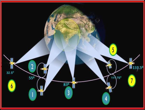
 Positioning Australia for its farming future Utilizing the Japanese satellite navigation QZSS system to provide centimetre positioning accuracy across ALL Australia David Lamb 1,2 and Phil Collier 2 1
Compact multi-gnss PPP corrections messages for transmission through a 250 bps channel
 Compact multi-gnss PPP corrections messages for transmission through a 250 bps channel Ken Harima, School of Science, RMIT University Suelynn Choy, School of Science, RMIT University Chris Rizos, School
GPS Geodetic Reference System WGS 84
 GPS Geodetic Reference System WGS 84 International Committee on GNSS Working Group D Saint Petersburg, Russia 16 September 2009 Barbara Wiley National Geospatial-Intelligence Agency United States of America
Other Space Geodetic Techniques. E. Calais Purdue University - EAS Department Civil 3273
 Other Space Geodetic Techniques E. Calais Purdue University - EAS Department Civil 3273 ecalais@purdue.edu Satellite Laser Ranging = SLR Measurement of distance (=range) between a ground station and a
Update on the International Terrestrial Reference Frame (ITRF)
") Update on the International Terrestrial Reference Frame (ITRF) Zuheir Altamimi Head of the IERS ITRF Product Center Institut National de l Information Géographique et Forestière IGN, France E-mail: zuheir.altamimi@ign.fr
Update on the International Terrestrial Reference Frame (ITRF) Zuheir Altamimi Head of the IERS ITRF Product Center Institut National de l Information Géographique et Forestière IGN, France E-mail: zuheir.altamimi@ign.fr
Global and Regional Real-Time Infrastructure for open access use
 Global and Regional Real-Time Infrastructure for open access use Axel Rülke Federal Agency for Cartography and Geodesy Branch Office Leipzig, Germany Tutorial on (Open) Real-Time Infrastructure and Applications
General Assembly. United Nations A/AC.105/946
 United Nations A/AC.105/946 General Assembly Distr.: General 16 November 2009 Original: English Committee on the Peaceful Uses of Outer Space Report on the United Nations/Azerbaijan/United States of America/European
Global Navigation Satellite System (GNSS) for Disaster Mitigation
 for Disaster Mitigation") Global Navigation Satellite System (GNSS) for Disaster Mitigation By Chathura H. Wickramasinghe Geoinformatics Center Asian Institute of Technology Establish in 1959 as a Post Graduate School Catering
Global Navigation Satellite System (GNSS) for Disaster Mitigation By Chathura H. Wickramasinghe Geoinformatics Center Asian Institute of Technology Establish in 1959 as a Post Graduate School Catering
GAVIN DOCHERTY & CRAIG ROBERTS School of Surveying & Spatial Information Systems. University of NSW
 FIG2010, Sydney, Australia 15 April 2010 The impact of Solar Cycle 24 on Network RTK in Australia GAVIN DOCHERTY & CRAIG ROBERTS School of Surveying & Spatial Information Systems University of NSW School
Future GNSS Precision Applications. Stuart Riley
 Future GNSS Precision Applications Stuart Riley Major Trimble Precision Markets Survey Mostly person portable equipment Construction Machine control and person carried equipment Includes Marine applications
Other Space Geodetic Techniques. E. Calais Purdue University - EAS Department Civil 3273
 Other Space Geodetic Techniques E. Calais Purdue University - EAS Department Civil 3273 ecalais@purdue.edu Satellite Laser Ranging Measurement of distance (=range) between a ground station and a satellite
What makes the positioning infrastructure work. Simon Kwok Chairman, Land Surveying Division Hong Kong Institute of Surveyors
 What makes the positioning infrastructure work The experience of the Hong Kong Satellite Positioning Reference Station Network Simon Kwok Chairman, Land Surveying Division Hong Kong Institute of Surveyors
Space Weather influence on satellite based navigation and precise positioning
 Space Weather influence on satellite based navigation and precise positioning R. Warnant, S. Lejeune, M. Bavier Royal Observatory of Belgium Avenue Circulaire, 3 B-1180 Brussels (Belgium) What this talk
Precise Positioning... what does it mean? Precise GNSS Positioning Not just a niche technology. Chris Rizos 15/12/15
 Precise GNSS Positioning Not just a niche technology Chris Rizos Precise Positioning... what does it mean? 1 Precise Positioning... a spectrum of users... Few mm 1cm 2cm < dm 1dm sub-m Precision agriculture
GAMIT/GLOBK for GNSS. Material from R. W. King, T. A. Herring, M. A. Floyd (MIT) and S. C. McClusky (now at ANU)
 and S. C. McClusky (now at ANU)") GAMIT/GLOBK for GNSS M. A. Floyd Massachusetts Institute of Technology, Cambridge, MA, USA GPS Data Processing and Analysis with GAMIT/GLOBK and track GNS Science, Lower Hutt, New Zealand 26 February 2
GAMIT/GLOBK for GNSS M. A. Floyd Massachusetts Institute of Technology, Cambridge, MA, USA GPS Data Processing and Analysis with GAMIT/GLOBK and track GNS Science, Lower Hutt, New Zealand 26 February 2
The realization of a 3D Reference System
 The realization of a 3D Reference System Standard techniques: topographic surveying and GNSS Observe angles and distances either between points on the Earth surface or to satellites and stars. Do not observe
Report of the Working Group B: Enhancement of Global Navigation Satellite Systems (GNSS) Services Performance
 Services Performance") Report of the Working Group B: Enhancement of Global Navigation Satellite Systems (GNSS) Services Performance 1. The Working Group on Enhancement of Global Navigation Satellite Systems (GNSS) Service Performance
Report of the Working Group B: Enhancement of Global Navigation Satellite Systems (GNSS) Services Performance 1. The Working Group on Enhancement of Global Navigation Satellite Systems (GNSS) Service Performance
The Geodetic Reference Antenna in Space (GRASP): A Mission to Enhance the Terrestrial Reference Frame
: A Mission to Enhance the Terrestrial Reference Frame") The Geodetic Reference Antenna in Space (GRASP): A Mission to Enhance the Terrestrial Reference Frame Yoaz Bar-Sever, R. Steven Nerem, and the GRASP Team The Most Complete Geodesy Mission Collocate all
The Geodetic Reference Antenna in Space (GRASP): A Mission to Enhance the Terrestrial Reference Frame Yoaz Bar-Sever, R. Steven Nerem, and the GRASP Team The Most Complete Geodesy Mission Collocate all
UNAVCO's Community Planning for real-time GPS in Earthscope's Plate Boundary Observatory
 Click to edit Master slide title UNAVCO's Community Planning for real-time GPS in Earthscope's Plate Boundary Observatory Chuck Meertens (presenting Author) David Mencin William Hammond John Langbein Bob
BeiDou Orbit Determination Processes and Products in JPL's GDGPS System
 BeiDou Orbit Determination Processes and Products in JPL's GDGPS System Ant Sibthorpe, Yoaz Bar-Sever, Willy Bertiger, Wenwen Lu, Robert Meyer, Mark Miller and Larry Romans Outline GNSS (GPS/BDS) with
Sounding the Atmosphere Ground Support for GNSS Radio-Occultation Processing
 Sounding the Atmosphere Ground Support for GNSS Radio-Occultation Processing Atmospheric Sounding René Zandbergen & John M. Dow Navigation Support Office, Ground Systems Engineering Department, Directorate
The added value of new GNSS to monitor the ionosphere
 The added value of new GNSS to monitor the ionosphere R. Warnant 1, C. Deprez 1, L. Van de Vyvere 2 1 University of Liege, Liege, Belgium. 2 M3 System, Wavre, Belgium. Monitoring TEC for geodetic applications
EXPERIMENTAL RESULTS OF LEX CORRECTIONS USING FARMING MACHINE
 Sixth Meeting of the International Committee on Global Navigation Satellite Systems (ICG) EXPERIMENTAL RESULTS OF LEX CORRECTIONS USING FARMING MACHINE Masayuki Kanzaki Hitachi Zosen Corporation Prof.
GNSS Buoy Array in the Ocean for a Synthetic Geohazards Monitoring System
 GNSS Buoy Array in the Ocean for a Synthetic Geohazards Monitoring System Teruyuki Kato, Earthq. Res. Inst., Univ. Tokyo, Japan Yukihiro Terada, Nat. Inst. Tech., Kochi Col., Japan Keiichi Tadokoro, Grad.
(CSES) Introduction for China Seismo- Electromagnetic Satellite
 Introduction for China Seismo- Electromagnetic Satellite") Introduction for China Seismo- Electromagnetic Satellite (CSES) Wang Lanwei Working Group of China Earthquake-related related Satellites Mission China Earthquake Administration Outline Project Objectives
Introduction for China Seismo- Electromagnetic Satellite (CSES) Wang Lanwei Working Group of China Earthquake-related related Satellites Mission China Earthquake Administration Outline Project Objectives
GPS and Recent Alternatives for Localisation. Dr. Thierry Peynot Australian Centre for Field Robotics The University of Sydney
 GPS and Recent Alternatives for Localisation Dr. Thierry Peynot Australian Centre for Field Robotics The University of Sydney Global Positioning System (GPS) All-weather and continuous signal system designed
Positioning, location data and GNSS as solution for Autonomous driving
 Positioning, location data and GNSS as solution for Autonomous driving Jarkko Koskinen, Heidi Kuusniemi, Juha Hyyppä, Sarang Thombre and Martti Kirkko-Jaakkola FGI, NLS Definition of the Arctic 66 34 N
GNSS Accuracy Improvements through Multipath Mitigation with New Signals and services
 GNSS Accuracy Improvements through Multipath Mitigation with New Signals and services Andrey Veytsel, Ph.D Moscow Technical University 10 Meeting of the International Committee on Global Navigation Satellite
The International GNSS Service: In the Service of Geoscience and the Geospatial Industry
 International Global Navigation Satellite Systems Society IGNSS Symposium 2007 The University of New South Wales, Sydney, Australia 4 6 December, 2007 The International GNSS Service: In the Service of
ESOC s Multi-GNSS Processing
 ESOC s Multi-GNSS Processing Cristina Garcia-Serrano, Tim Springer, Florian Dilssner, Claudia Flohrer, Erik Schönemann, Werner Enderle ESOC - Navigation Support Office, Darmstadt, Germany IGS Workshop
PRECISE RECEIVER CLOCK OFFSET ESTIMATIONS ACCORDING TO EACH GLOBAL NAVIGATION SATELLITE SYSTEMS (GNSS) TIMESCALES
 TIMESCALES") ARTIFICIAL SATELLITES, Vol. 52, No. 4 DOI: 10.1515/arsa-2017-0009 PRECISE RECEIVER CLOCK OFFSET ESTIMATIONS ACCORDING TO EACH GLOBAL NAVIGATION SATELLITE SYSTEMS (GNSS) TIMESCALES Thayathip Thongtan National
ARTIFICIAL SATELLITES, Vol. 52, No. 4 DOI: 10.1515/arsa-2017-0009 PRECISE RECEIVER CLOCK OFFSET ESTIMATIONS ACCORDING TO EACH GLOBAL NAVIGATION SATELLITE SYSTEMS (GNSS) TIMESCALES Thayathip Thongtan National
magicgnss: QUALITY DATA, ALGORITHMS AND PRODUCTS FOR THE GNSS USER COMMUNITY
 SEMANA GEOMATICA 2009 magicgnss: QUALITY DATA, ALGORITHMS AND PRODUCTS FOR THE GNSS USER COMMUNITY MARCH 3, 2009 BARCELONA, SPAIN SESSION: GNSS PRODUCTS A. Mozo P. Navarro R. Píriz D. Rodríguez March 3,
Athanassios Ganas, Research Director, NOA
 Advanced GNSS techniques for earthquake assessment and monitoring Athanassios Ganas, aganas@noa.gr Research Director, NOA NOA GPS Project http://www.gein.noa.gr/gps.html Hemus NET Project http://www.hemus-net.org/
GNSS Technologies. PPP and RTK
 PPP and RTK 29.02.2016 Content Carrier phase based positioning PPP RTK VRS Slides based on: GNSS Applications and Methods, by S. Gleason and D. Gebre-Egziabher (Eds.), Artech House Inc., 2009 http://www.gnssapplications.org/
Supplement to. Global navigation satellite systems (GNSS) L E C T U R E. Zuzana Bělinová. TELEMATIC SYSTEMS AND THEIR DESIGN part Systems Lecture 5
 L E C T U R E. Zuzana Bělinová. TELEMATIC SYSTEMS AND THEIR DESIGN part Systems Lecture 5") Zuzana Bělinová L E C T U R E 5 Supplement to Global navigation satellite systems (GNSS) Recapitulation Satellite navigation systems Zuzana Bělinová History of satellite navigation USA USA 1960 TRANSIT
Zuzana Bělinová L E C T U R E 5 Supplement to Global navigation satellite systems (GNSS) Recapitulation Satellite navigation systems Zuzana Bělinová History of satellite navigation USA USA 1960 TRANSIT
To Estimate The Regional Ionospheric TEC From GEONET Observation
 To Estimate The Regional Ionospheric TEC From GEONET Observation Jinsong Ping(Email: jsping@miz.nao.ac.jp) 1,2, Nobuyuki Kawano 2,3, Mamoru Sekido 4 1. Dept. Astronomy, Beijing Normal University, Haidian,
COMPARISON BETWEEN BROADCAST AND PRECISE ORBITS: GPS GLONASS GALILEO AND BEIDOU. A. Caporali and L. Nicolini University of Padova, Italy
 COMPARISON BETWEEN BROADCAST AND PRECISE ORBITS: GPS GLONASS GALILEO AND BEIDOU A. Caporali and L. Nicolini University of Padova, Italy Summary Previous works Input data and method used Comparison between
International GNSS Monitoring & Assessment Service for OS (igmas) ICG September 2011, Tokyo, Japan
 ICG September 2011, Tokyo, Japan") Presentation on igmas FOR WORKING GROUP A International GNSS Monitoring & Assessment Service for OS (igmas) by Xurong Dong International Cooperation Research Centre, CSNO ICG 6 5 9 September 2011, Tokyo,
Presentation on igmas FOR WORKING GROUP A International GNSS Monitoring & Assessment Service for OS (igmas) by Xurong Dong International Cooperation Research Centre, CSNO ICG 6 5 9 September 2011, Tokyo,
QZSS and LEX Signal. Performance of Real-Time Precise Point Positioning Using MADOCA-LEX Augmentation Messages. Outline
 Performance of Real-Time Precise Point Positioning Using MADOCA-LEX Augmentation Messages Suelynn Choy 1, Ken Harima 1, Mohammad Choudhury 2, Yong Li 2, Yaka Wakabayashi 3, Thomas Grinter 4, Satoshi Kogure
Precise Point Positioning with BeiDou
 Precise Point Positioning with BeiDou Ole Ørpen Fugro Satellite Positioning AS Geodesi- og Hydrografidagene Stavanger, 12-13 Nov. 2014 Fugro 2013 Contents The G2 service Galileo Testing 2013 BeiDou Testing
GPS the Interdisciplinary Chameleon: How Does it do That?
 GPS the Interdisciplinary Chameleon: How Does it do That? Geoff Blewitt Nevada Bureau of Mines and Geology & Seismological Laboratory University of Nevada, Reno, USA Cool Science using GPS Application
An overview of the COSMIC follow-on mission (COSMIC-II) and its potential for GNSS-R
 and its potential for GNSS-R") An overview of the COSMIC follow-on mission (COSMIC-II) and its potential for GNSS-R Lidia Cucurull (1), Dave Ector (2), and Estel Cardellach (3) (1) NOAA/NWS/NCEP/EMC (2) NOAA/NESDIS/OSD (3) IEEC/ICE-CSIC
An overview of the COSMIC follow-on mission (COSMIC-II) and its potential for GNSS-R Lidia Cucurull (1), Dave Ector (2), and Estel Cardellach (3) (1) NOAA/NWS/NCEP/EMC (2) NOAA/NESDIS/OSD (3) IEEC/ICE-CSIC
Report on GNSS Training
 Report on GNSS Training Course ID: T141-30 Afghanistan, Australia, Austria, Bangladesh, Bhutan, Cambodia, India, Indonesia, Japan, Maldives, Mongolia, Nepal, The Philippines, Sri Lanka, Tajikistan, Thailand,
International Committee on Global Navigation Satellite Systems (ICG)
") International Committee on Global Navigation Satellite Systems (ICG) A forum to discuss global navigation satellite systems to benefit people around the world Sharafat Gadimova United Nations Office for
International Committee on Global Navigation Satellite Systems (ICG) A forum to discuss global navigation satellite systems to benefit people around the world Sharafat Gadimova United Nations Office for
GLOBAL POSITIONING SYSTEMS. Knowing where and when
 GLOBAL POSITIONING SYSTEMS Knowing where and when Overview Continuous position fixes Worldwide coverage Latitude/Longitude/Height Centimeter accuracy Accurate time Feasibility studies begun in 1960 s.
PageNET: In Support of the Surveying Community
 Philippine Active Geodetic Network : In Support of the Surveying Community ICG Experts Meeting: Global Navigation Satellite Systems Services Vienna International Center, Vienna, Austria December 14-18,
FieldGenius Technical Notes GPS Terminology
 FieldGenius Technical Notes GPS Terminology Almanac A set of Keplerian orbital parameters which allow the satellite positions to be predicted into the future. Ambiguity An integer value of the number of
Prospect for Global Positioning Augmentation Service by QZSS
 Prospect for Global Positioning Augmentation Service by QZSS Global Positioning Augmentation Service Corporation Director, Yoshikatsu Iotake Feb. 6, 2018 Copyright 2018 Global Positioning Augmentation
King AbdulAziz University. Faculty of Environmental Design. Geomatics Department. Mobile GIS GEOM 427. Lecture 3
 King AbdulAziz University Faculty of Environmental Design Geomatics Department Mobile GIS GEOM 427 Lecture 3 Ahmed Baik, Ph.D. Email: abaik@kau.edu.sa Eng. Fisal Basheeh Email: fbasaheeh@kau.edu.sa GNSS
Asian Journal of Science and Technology Vol. 08, Issue, 11, pp , November, 2017 RESEARCH ARTICLE
 Available Online at http://www.journalajst.com ASIAN JOURNAL OF SCIENCE AND TECHNOLOGY ISSN: 0976-3376 Asian Journal of Science and Technology Vol. 08, Issue, 11, pp.6697-6703, November, 2017 ARTICLE INFO