Global Navigation Satellite System (GNSS) for Disaster Mitigation
|
|
|
- Mary O’Brien’
- 6 years ago
- Views:
Transcription
1 Global Navigation Satellite System (GNSS) for Disaster Mitigation By Chathura H. Wickramasinghe Geoinformatics Center Asian Institute of Technology

2 Establish in 1959 as a Post Graduate School Catering for higher education in Asia 1,967 students from 46 countries 18,020 alumni from 74 countries 22,000 short-term trainees from 71 countries 120 faculty from 26 countries
3 AIT Academic Structure School of Engineering and Technology Computer Science Design and Manufacturing Engineering Industrial Engineering and Management Information Management Remote Sensing and Geographic Information Systems Telecommunications Information and Communications Technologies Mechatronics Microelectronics Construction, Engineering and Infrastructure Management Geotechnical and Geoenvironmental Engineering Structural Engineering Transportation Engineering Water Engineering and Management GIC School of Environment Resources and Development Agricultural Systems and Engineering Aquaculture and Aquatic Resources Management Energy Environmental Engineering and Management Food Engineering and Bioprocess Technology Gender and Development Studies Natural Resources Management Pulp and Paper Technology Regional and Rural Development Planning Urban Environmental Management School of Management International Business International Public Management Management of Technology Service Marketing and Technology Executive MBA EMBA Bangkok EMBA Vietnam EMBA-HRM AIT Extension (Non-degree training, consultancy and services) Agriculture, Resources and Rural Development Business Management Development Management Education and Training Development Environment, Infrastructure and Urban Development Information and Communications Technology


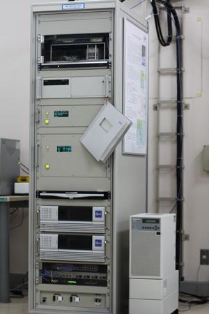
4 . Director : Dr Lal Samarakoon MODIS & NOAA Receiving station. QZSS Base station QZSS Base Station


5 Improving Real-Time PPP positioning by combining QZSS-LEX Massage and IGS Ultra-rapid products Mr. Chathura H Wickramasinghe Dr. Lal Samarkon Dr. Taravudh Tipdecho Dr. Manukid Parnichkun Geoinformatics Center Asian Institute of Technology
6 Content Multi GNSS Introduction QZSS Real Time Positioning Methods Research Question & Objectives PPP Positioning sensitivity Methodology Results Conclusion & recommendation
,QZSS(JAPAN) : GPS Augmentation system GNSS Satellite availability density for 24 hours when all the systems are fully functioning.")
7 Introduction to Multi GNSS Global Navigation Satellite System(GNSS) GPS(USA), GLONASS(RUSSIA), Galileo(EU), Compass(CHINA) : Global coverage IRNSS(INDIA): Regional coverage WASS(USA), EGNOS(EU),QZSS(JAPAN) : GPS Augmentation system GNSS Satellite availability density for 24 hours when all the systems are fully functioning. More than 30 satellites are visible Asia Oceania Region GNSS GPS GLONASS Galileo COMPASS IRNSS QZSS Source :


8 QZSS (Quasi-Zenith Satellite System) Japanese GPS Augmentation system. The consolation is to consist of 3 QZS satellites, First satellite was launched on 11 September 2011, Full operation is expected in Aims to improve GPS accuracy in Japan Urban environment Availability enhancement Near Zenith Orbit over Japan Performance improvement L1-SAIF and experimental LEX QZS transmit signals L1C/A,L1C, L2C, L5, L1-SAIF and LEX Source:
9 Post processing PPP accuracy is comparable with the DGPS accuracy (Kouba 2001), Real time positioning DGPS-RTK (Differential GPS-Real Time Kinematic) Uses an base station to calculate the error(differential correction) PPP(Precise Point Positioning) International GNSS Services (IGS) provides precise GPS Satellite ephemeris, clocks and Ionospheric correction data. Segment Standard deviation Errors source (m) Space Satellite clock stability 3.0 Control Ephemeris prediction 4.2 errors Ionospheric delay 5.0 Tropospheric delay 1.5 User Receiver noise and 1.5 resolution Multipath 2.5 Other 0.5 Table 2-2 GPS positioning error budget(kaplan 1996) Accuracy of PPP based positioning will depend the accuracy of the model


10 PPP vs DGPS-rtk PPP No need for base station Not limited to base line distance No ground infrastructure necessary No cost for country level implementation Need GSM coverage or LEX receiver DGPS-RTK Need Base station Limited to 100km of base line Need ground infrastructure High cost is necessary for country level network Need radio receiver or GSM module Automated Farming Self driving Car Auto landing Ground truth

11 Real time ppp There area two methods IGS(International GNSS services) Ultra rapid products GSM receiver: Good Internet connection Experimental QZS LEX signal QZSS LEX RF receiver Comparison of the two methods QZSS Limited to Satellite visibility Ideal for rural areas & urban areas Precise navigation and location in the sea Land side monitoring in hilly areas Precise Navigation for Aviation IGS Limited to GSM coverage Suited only for urban areas Not possible Not possible Not possible


12 Research Question? How accurate are the QZSS LEX correction data? Applicability of the LEX data for Thailand How can the LEX and IGS data be combined, to improve Realtime PPP positioning accuracy?
13 PPP Positioning accuracy Comparing PPP data products based positioning IGS Final products (post processing): IGS Ultra Rapid Products (real time) : LEX data (real time)
14 PPP Positioning accuracy CONT..

15 Objective Improve the accuracy of LEX PPP correction data by fusing with IGS PPP data products, to improve accuracy of real time positioning. Thus providing accurate positioning on land or sea without the limitation of IGS data.


16 Scope Research will only focus on the GPS ephemeris and clock errors and will consider that there are very little or no multipath errors in the observations. For the evaluation of QZS LEX massage data, IGS final product will be considered as the most accurate data for GPS satellite ephemeris and clocks(griffiths and Ray 2009).


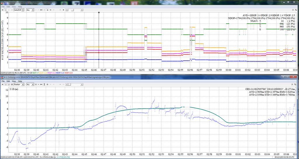
17 PPP sensitivity base on SV ephemeris & clocks How the accuracy of Ephemeris and Clocks will effect the positioning IGS Final product data was used. Constant error was added to the data. Clock correction accuracy has high sensitivity compared to Ephemeris Positioning error has exponential relationship

18 PPP sensitivity base on SV ephemeris & clocks cont.

19 Main Methodology Decode LEX data Analyze LEX & IGS Ephemeris and Clock correction data. Develop New Algorithm to fuse the data. Testing the New Algorithm


20 Decoding QZSS LEX massage LEX Massage In binary format Extracted Massage ID 10 data from LEX Massage


21 Extracted IGS data IGS data products are freely available online in SP3 format. IGS sp3 format New format
22 Analysis of LEX data Compare LEX SV (space vehicle) ephemeris and clock correction data with IGS products Daily error for all 30 GPS satellites Absolute Error for period of one week for all 30 GPS satellites PPP positioning analysis LEX based positioning LEX Corrected positioning IGS based positioning

23 IGS & LEX ephemeris data correlation Correlation coefficient between IGS Final products and LEX data quantifies the relationship between the two data sets. Ephemeris & Clock correction correlation coefficient Satellite SV X SV Y SV Z direction direction direction SV Clock Correlation High Low
24 LEX data ephemeris Error LEX X- axis error for SV 06 on Day 01 LEX data average ephemeris error is 1m
25 LEX axis Error variation throughout one week (SV-6 X) How the LEX X axis error varies through the week High Correlating Ephemeris error correlation coefficient SV X- axis SV Y - SV Z -axis axis Day 1 (6 th May ) Day 2 (7 th May ) Day 3(8 th May ) Day 4(9 th May ) Day 5(10 th May ) Day 6(11 th May )

26 LEX SV-6 Y axis Error variation throughout one week

27 LEX SV-6 Z axis error variation throughout one week Ephemeris error in LEX data is systematic and vary with time. Correction at the beginning of the week can be applied to the rest of the week
28 Polynomial fitting to remove the error Using Polynomial fitting to remove the error 14 th Order Polynomial for X,Y directions and 12 th Order for Z axis was analyzed as the best fit for all the satellites. First day error is used to calculate the coefficient values of the polynomial X = t t t t t t t t t t t X = poly fit equaiton forsv6 X axis t = daily time in seconds starting at ours daily X 10-3 X 10⁻⁴ Error after Polynomial fitting

29 Wavelet Analysis First approximation of Wavelet analysis was used to reduce the error even further Error Wavelet first approximation

30 Improvement in ephemeris error day 3: x-axis ephemeris error in SV 6 & 8 SV 6 Day 3 X axis error Poly fit + Wavelet has failed to improve the ephemeris SV 8 Day 3 X axis error Over all error is reduction is 0.4m

31 IMPROVEMENT IN EPHEMERIS ERROR DAY 3: Y-AXIS EPHEMERIS ERROR IN SV 6
32 IMPROVEMENT IN EPHEMERIS ERROR DAY 3: Z-AXIS EPHEMERIS ERROR IN SV 6 Poly fit Has failed to remove any errors More depth analysis of SV data must be carried out Because of the time constrain it was decided to use poly fit+ Wavelet


33 Five day absolute mean error value for Y axis To evaluate the performance of the new method through the week Error in LEX data due to outliers Error in correction Unable to correct outlier Over all 78% of satellites improved in the X, Y axis and 82% in the Z axis High Improvement in the ephemeris


34 Five day absolute mean error value for x, z axis
35 Single day improvement on selected satellites 7 th of May 2012 X direction absolute mean error improvement shows the error was reduced to 0.2m from 0.8m, Improvement of 24%. < 0.8 m < 0.2 m
 SV LEX Poly fit Poly fit + Wavelet 02 23.033 5.023 x10⁻⁴ 4.764 x10⁻⁴ 03 3.1591x0-3 7.773 x10⁻⁴ 5.11 x10⁻⁴ 08 6.362 0.338 4.932 x10⁻⁴ 13 1.")
36 Ephemeris improvement: quantitative Five day absolute mean error for selected satellites ephemeris show the correction method was effective in reducing the error through the week. Five day absolute mean error value in X direction (km) SV LEX Poly fit Poly fit + Wavelet x x x x x x x x x x x x10-4 Very low values after correction Correction method was able to reduce the error to around 0.4m compared to 1m error in LEX data.
37 Clock correction error variation Low correlation between the IGS and LEX clock is due to the fact the LEX clock correction is an constant value rather than the actual changing value Gradually changing clock correction Constant value for LEX clock correction
 11.30-12.30 hours 23.00-24.00 hours 02-0.0097-0.")
38 Clock correction New equation was developed for clock correction Based on the analysis of the LEX Clock correction data c = C IGS + g t c = SV clock correction C IGS = Initial IGS clock correction g = Calculated IGS clock drifting gradient t = Obervation time from C IGS initial epoc SV to hours Day 3 IGS Clock error drift (microseconds) hours hours Clock correction has almost the same gradient through the day
39 New Clock correction Accuracy Results show the new method has kept an a accuracy of 0.01 microseconds After 6 days. Where as LEX error is one microsecond SV LEX Clock Correction error :Day 04 (Microseconds ) Clock correction accuracy comparison New Method error : Day 4 (Microseconds) Clock correction value on 11 th (Day 6) May 1:00:00h (Microseconds) IGS New method LEX Starting day for the week is th May
40 New Algorithm for LEX data correction LEX Data Ephemeris Data IGS data Post process Calculate Error IGS Clock Correction Outlier remover Generate error Polynomial Error Correction Generate Wavelet Approximation SV clock drift Clock Correction drift calculation Real Time Process Ephemeris Data Real time LEX Correction New SV Ephemeris & Clocks PPP Observation time Observation data NEW POSITION
41 Positioning improvement cont... SV has not been taken for analysis as they did not improve accuracy In the ephemeris Day 2 Corrected LEX and LEX based PPP positioning comparison Corrected LEX LEX Root Mean Square Error Correct ed (m) LEX (m) E N U D hour period with 15 munities interval
42 Positioning improvement cont... Day 3 Corrected LEX and LEX based PPP positioning Corrected LEX LEX Root Mean Square Error Correct ed(m) LEX (m) E N U D
43 Positioning improvement cont... Day 4 Corrected LEX and LEX based PPP positioning Corrected LEX LEX Corrected LEX LEX Root Mean Square Error Correct LEX ed (m) (m) E N U D hour period with 15 munities interval
44 Positioning improvement cont... Day 5 Corrected LEX and LEX based PPP positioning Corrected LEX LEX Root Mean Square Error Correct ed (m) LEX (m) E N U D hour period with 15 munities interval
45 Positioning: LEX CORRECTED & IGS Day 5 IGS Ultra rapid and Corrected LEX based PPP positioning IGS Ultra rapid Corrected LEX Root Mean Square Error Corre cted (m) IGS (m) LEX (m) E N U D hour period with 15 munities interval
46 Positioning improvement cont... Day 6 Corrected LEX and LEX based PPP positioning comparison for Day 6 Corrected LEX LEX Root Mean Square Error Correct ed (m) LEX (m) E N U D hour period with 15 munities interval

 LEX Corrected LEX Day 2D Height 2D Height 02 0.206 0.7745 0.3786 0.8174 03 0.311 1.6844 0.4394 0.")
47 Positioning accuracy improvement Day 5 IGS Ultra rapid, LEX and LEX Corrected positioning error Root Mean Square (m) Standard Deviation (m) Position IGS LEX LEX IGS Ultra LEX LEX Ultra Rapid Corrected Rapid Corrected Nothing Easting D Elevation New algorithm has improved the 2D positioning accuracy by 0.15m It improve the Elevation accuracy with error of 0.47m Weekly average positioning errors for LEX and LEX Corrected data Positioning error RMS (M) LEX Corrected LEX Day 2D Height 2D Height Averag e LEX Corrected has high standard deviation compared to LEX New algorithm kept the improved 2D positioning accuracy by 0.15m But the average elevation is better in LEX due to 40% of corrected data showed high error.


48 Software Tools Developed LEX Massage decoder & data extractor. LEX to SP3 converter. LEX data Corrector. LEX Massage Generator.
49 Conclusion New Algorithm developed by fusing LEX, IGS data improved the over all LEX PPP positioning accuracy by 37%. The New Algorithm has improved the LEX based positioning The new algorithm was able to effectively identify and remove outliers in the LEX data. Analysis showed IGS Ultra Rapid data provides the best possible real time positioning solution for PPP given that GSM coverage is available.

50 Multi-GNSS Joint Experiment QZSS based real time PPP observation for slow moving flood detection


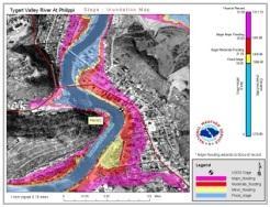
51 Flood Modeling Flood Models : HEC-RAS, MIKE11, and TELEMAC-2D Flood Modeling Accuracy Accuracy of the DEM Number of river gaging stations Changing ground situation


52 Research Question How to improve the flood modeling accuracy using GNSS? Accurate DEM. Changes with sand bags. Flood height data. Real ground situation
53 Objective First stage Identify measurable minimum vertical movement using real time PPP(Precise Point Positioning) QZSS-LEX. Develop algorithm to accurately calculate the flood water increasing rate using QZSS-LEX based PPP. Final Target Develop real time flood monitoring sensor network and new flood model that can use the data for real time dynamic flood modeling.
54 Why use PPP PPP No need for base station Not limited to base line distance No ground infrastructure necessary No cost for country level implementation DGPS-RTK Need Base station (can be flooded) Limited to 100km of base line Need ground infrastructure High cost is necessary for country level network Why QZSS LEX based PPP? Does not depend on Internet connection

55 Sensor GNSS receiver(qzss LEX) Height calculation GSM Module Transmit data Digital Rain Gage Rain fall data Gyroscope Detect movement Digital Camera Visual verification Micro computer To process the data and Identify accurate elevation changes


56 System Frame Work GPS Satellites QZSS Satellites QZSS Emergency massage Flood Modeling L1,LE X GSM Network Central Monitoring Station

57 Advantages Highly accurate flood monitoring. Any location Chang data gathering point according to the situation. Accurate mitigation Monitor how ground situation is deviation from the model and response. Sand bag walls will change the water flow. Centralized system. Relatively low implementation cost.
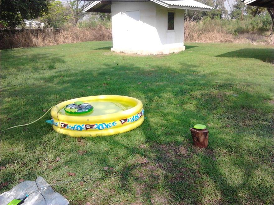
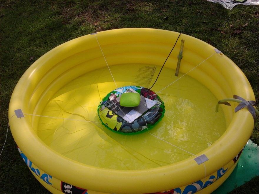
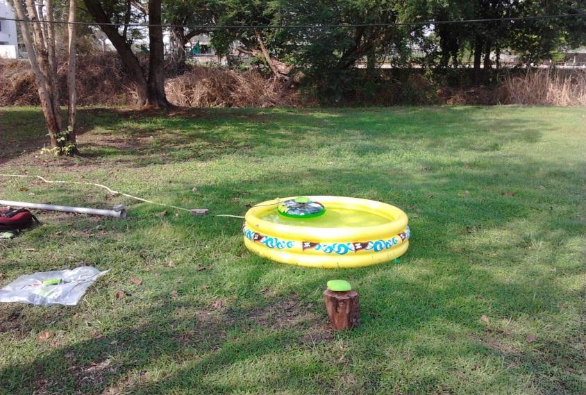
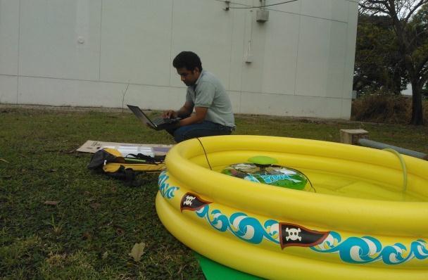
58 Data Collection
59 Initial observation data Average Water increasing rate cm/sec Linear fit Gradient cm/sec
60 Initial observation data Average Water increasing rate cm/sec Linear fit Gradient cm/sec
61 Initial observation data decreasing water Average Water increasing rate cm/sec Linear fit Gradient 0.03cm/sec
62 Initial observation data Average Water increasing rate cm/sec
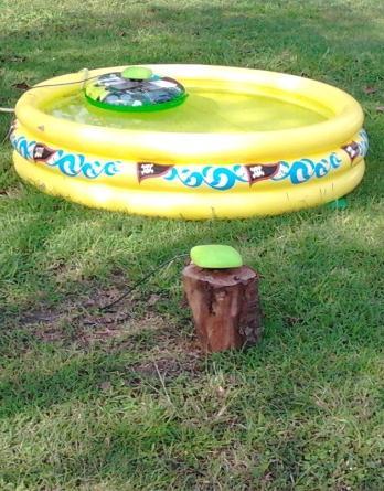
63 Initial observation data Cont..
64 Next step Analyzing the GNSS Observation data. Test with low cost IMU. Develop an algorithm that will accurately identify the flooding rate.


65
Potential use of QZSS monitoring station for future research. Kavinda Gunasekara Geoinformatics Center Asian Institute of Technology
 Potential use of QZSS monitoring station for future research Kavinda Gunasekara Geoinformatics Center Asian Institute of Technology Geoinformatics Center Established in 1999 Over 1,600 Graduate students
Quasi-Zenith Satellite System (QZSS)
") Transmission of Augmentation Corrections using the Japanese QZSS for Real-Time Precise Point Positioning in Australia Ken Harima 1, Suelynn Choy 1, Mazher Choudhury 2, Chris Rizos 2, Satoshi Kogure 3 1
Transmission of Augmentation Corrections using the Japanese QZSS for Real-Time Precise Point Positioning in Australia Ken Harima 1, Suelynn Choy 1, Mazher Choudhury 2, Chris Rizos 2, Satoshi Kogure 3 1
Effect of Quasi Zenith Satellite (QZS) on GPS Positioning
 on GPS Positioning") Effect of Quasi Zenith Satellite (QZS) on GPS ing Tomoji Takasu 1, Takuji Ebinuma 2, and Akio Yasuda 3 Laboratory of Satellite Navigation, Tokyo University of Marine Science and Technology 1 (Tel: +81-5245-7365,
Effect of Quasi Zenith Satellite (QZS) on GPS ing Tomoji Takasu 1, Takuji Ebinuma 2, and Akio Yasuda 3 Laboratory of Satellite Navigation, Tokyo University of Marine Science and Technology 1 (Tel: +81-5245-7365,
Current status of Quasi-Zenith Satellite System. Japan Aerospace Exploration Agency QZSS Project Team
 Current status of Quasi-Zenith Satellite System Japan Aerospace Exploration Agency QZSS Project Team 1 Quasi-Zenith Satellite System The QZSS is a regional space-based PNT (Positioning, Navigation and
The technical contribution of QZSS and GNSS to Tsunami early warning system
 0/17 Tsunami Workshop by Sentinel Asia @Sendai International Center Meeting Room 5 The technical contribution of QZSS and GNSS to Tsunami early warning system July 3, 2012 K. Mutoh, J. Yamashita, and S.
EXPERIMENTAL RESULTS OF LEX CORRECTIONS USING FARMING MACHINE
 Sixth Meeting of the International Committee on Global Navigation Satellite Systems (ICG) EXPERIMENTAL RESULTS OF LEX CORRECTIONS USING FARMING MACHINE Masayuki Kanzaki Hitachi Zosen Corporation Prof.
GPS and Recent Alternatives for Localisation. Dr. Thierry Peynot Australian Centre for Field Robotics The University of Sydney
 GPS and Recent Alternatives for Localisation Dr. Thierry Peynot Australian Centre for Field Robotics The University of Sydney Global Positioning System (GPS) All-weather and continuous signal system designed
Introduction to GNSS Base-Station
 Introduction to GNSS Base-Station Dinesh Manandhar Center for Spatial Information Science The University of Tokyo Contact Information: dinesh@iis.u-tokyo.ac.jp Slide : 1 Introduction GPS or GNSS observation
Assessment of GNSS Ionospheric Scintillation and TEC Monitoring Using the Multi-constellation GPStation-6 Receiver
 Assessment of GNSS Ionospheric Scintillation and TEC Monitoring Using the Multi-constellation GPStation-6 Receiver Rod MacLeod Regional Manager Asia/Pacific NovAtel Australia Pty Ltd Outline Ionospheric
GNSS Accuracy Improvements through Multipath Mitigation with New Signals and services
 GNSS Accuracy Improvements through Multipath Mitigation with New Signals and services Andrey Veytsel, Ph.D Moscow Technical University 10 Meeting of the International Committee on Global Navigation Satellite
High Precision Navigation Capabilities(L1-SAIF) and Applications Using Japanese Quasi-Zenith Satellite System (QZSS)
 and Applications Using Japanese Quasi-Zenith Satellite System (QZSS)") High Precision Navigation Capabilities(L1-SAIF) and Applications Using Japanese Quasi-Zenith Satellite System (QZSS) ICG WG-B Application SG Meeting Munich, Germany March 12, 2012 Satellite Positioning
High Precision Navigation Capabilities(L1-SAIF) and Applications Using Japanese Quasi-Zenith Satellite System (QZSS) ICG WG-B Application SG Meeting Munich, Germany March 12, 2012 Satellite Positioning
Asia Oceania Regional Workshop on GNSS Precise Point Positioning Experiment by using QZSS LEX
 Asia Oceania Regional Workshop on GNSS 2010 Precise Point Positioning Experiment by using QZSS LEX Tomoji TAKASU Tokyo University of Marine Science and Technology Contents Introduction of QZSS LEX Evaluation
Approach to the era of Multi-GNSS (GEONET by GSI : part2)
") Approach to the era of Multi-GNSS (GEONET by GSI : part2) Tetsuro IMAKIIRE (Geospatial Information Authority of Japan) Contents 1. Multi GNSS environment 1.1 Expansion of GNSS 1.2 QZSS 2. Utility of Multi
Approach to the era of Multi-GNSS (GEONET by GSI : part2) Tetsuro IMAKIIRE (Geospatial Information Authority of Japan) Contents 1. Multi GNSS environment 1.1 Expansion of GNSS 1.2 QZSS 2. Utility of Multi
QZSS and LEX Signal. Performance of Real-Time Precise Point Positioning Using MADOCA-LEX Augmentation Messages. Outline
 Performance of Real-Time Precise Point Positioning Using MADOCA-LEX Augmentation Messages Suelynn Choy 1, Ken Harima 1, Mohammad Choudhury 2, Yong Li 2, Yaka Wakabayashi 3, Thomas Grinter 4, Satoshi Kogure
Positioning Australia for its farming future
 Positioning Australia for its farming future Utilizing the Japanese satellite navigation QZSS system to provide centimetre positioning accuracy across ALL Australia David Lamb 1,2 and Phil Collier 2 1
Establishment of Regional Navigation Satellite System Utilizing Quasi-Zenith Satellite System
 Establishment of Regional Navigation Satellite System Utilizing Quasi-Zenith Satellite System Authors: Masayuki Saito*, Junichi Takiguchi* and Takeshi Okamoto* 1. Introduction The Global Navigation Satellite
Modelling GPS Observables for Time Transfer
 Modelling GPS Observables for Time Transfer Marek Ziebart Department of Geomatic Engineering University College London Presentation structure Overview of GPS Time frames in GPS Introduction to GPS observables
Challenges and Solutions for GPS Receiver Test
 Challenges and Solutions for GPS Receiver Test Presenter: Mirin Lew January 28, 2010 Agenda GPS technology concepts GPS and GNSS overview Assisted GPS (A-GPS) Basic tests required for GPS receiver verification
Prospect for Global Positioning Augmentation Service by QZSS
 Prospect for Global Positioning Augmentation Service by QZSS Global Positioning Augmentation Service Corporation Director, Yoshikatsu Iotake Feb. 6, 2018 Copyright 2018 Global Positioning Augmentation
King AbdulAziz University. Faculty of Environmental Design. Geomatics Department. Mobile GIS GEOM 427. Lecture 3
 King AbdulAziz University Faculty of Environmental Design Geomatics Department Mobile GIS GEOM 427 Lecture 3 Ahmed Baik, Ph.D. Email: abaik@kau.edu.sa Eng. Fisal Basheeh Email: fbasaheeh@kau.edu.sa GNSS
One Source for Positioning Success
 novatel.com One Source for Positioning Success RTK, PPP, SBAS OR DGNSS. NOVATEL CORRECT OPTIMIZES ALL CORRECTION SOURCES, PUTTING MORE POWER, FLEXIBILITY AND CONTROL IN YOUR HANDS. NovAtel CORRECT is the
Trimble GNSS Infrastructure
 Trimble GNSS Infrastructure A History of Innovation Trimble, the first company to offer commercial GPS products company to integrate GPS with communications technology RTK system in the market in 1994
Report on a Multi-GNSS Demonstration project in the Asia/Oceania region
 Report on a Multi-GNSS Demonstration project in the Asia/Oceania region - Asia Oceania is the Showcase of New GNSS Era - Japan Aerospace Exploration Agency ICG 5@Turin, Italy October 19, 2010 1 Back Ground
Current Status of the Japanese Quasi-Zenith Satellite System (QZSS)
") Current Status of the Japanese Quasi-Zenith Satellite System (QZSS) 12 November 2008 Koji TERADA QZSS Project Manager Japan Aerospace Exploration Agency Contents Introduction Concept of the QZSS System
Current Status of the Japanese Quasi-Zenith Satellite System (QZSS) 12 November 2008 Koji TERADA QZSS Project Manager Japan Aerospace Exploration Agency Contents Introduction Concept of the QZSS System
THE CURRENT STATUS OF ASIA OCEANIA MULTI-GNSS DEMONSTRATION CAMPAIGN. Multi-GNSS Asia Secretariat June 4 th, th ICG Providers Forum
 THE CURRENT STATUS OF ASIA OCEANIA MULTI-GNSS DEMONSTRATION CAMPAIGN 1 Multi-GNSS Asia Secretariat June 4 th, 2012 8 th ICG Providers Forum ASIA OCEANIA MULTI-GNSS DEMONSTRATION CAMPAIGN Multi-GNSS Monitoring
1. INTRODUCTION. Longitude, deg In contrast to the global systems such as GPS, GLONASS and
 SPECIAL REPORT Highly-Accurate Positioning Experiment Using QZSS at ENRI Ken Ito Electronic Navigation Research Institute (ENRI) 1. INTRODUCTION P ositioning with GPS is widely used in Japan in the area
Global Navigation Satellite Systems II
 Global Navigation Satellite Systems II AERO4701 Space Engineering 3 Week 4 Last Week Examined the problem of satellite coverage and constellation design Looked at the GPS satellite constellation Overview
Performance Evaluation of the Effect of QZS (Quasi-zenith Satellite) on Precise Positioning
 on Precise Positioning") Performance Evaluation of the Effect of QZS (Quasi-zenith Satellite) on Precise Positioning Nobuaki Kubo, Tomoko Shirai, Tomoji Takasu, Akio Yasuda (TUMST) Satoshi Kogure (JAXA) Abstract The quasi-zenith
Performance Evaluation of the Effect of QZS (Quasi-zenith Satellite) on Precise Positioning Nobuaki Kubo, Tomoko Shirai, Tomoji Takasu, Akio Yasuda (TUMST) Satoshi Kogure (JAXA) Abstract The quasi-zenith
High Precision GNSS in Automotive
 High Precision GNSS in Automotive Jonathan Auld, VP Engineering and Safety 6, March, 2018 2 Global OEM Positioning Solutions and Services for Land, Sea, and Air. GNSS in Automotive Today Today the primary
The Current Status of QZSS Program
 The Current Status of QZSS Program Satoshi Kogure Japan Aerospace Exploration Agency (JAXA) October 21, 2015 International Association of Institute of Navigation World Cogress 2015 @Prague, Czech Republic
The Global Positioning System
 The Global Positioning System 5-1 US GPS Facts of Note DoD navigation system First launch on 22 Feb 1978, fully operational in 1994 ~$15 billion (?) invested to date 24 (+/-) Earth-orbiting satellites
Development of an Open Source Multi GNSS Data Processing Software
 2nd Asia Oceania Regional Workshop on GNSS 2010 Development of an Open Source Multi GNSS Data Processing Software Tomoji TAKASU Tokyo University of Marine Science and Technology Contents Introduction Issues
GPS Milestones, cont. GPS Milestones. The Global Positioning Sytem, Part 1 10/10/2017. M. Helper, GEO 327G/386G, UT Austin 1. US GPS Facts of Note
 The Global Positioning System US GPS Facts of Note DoD navigation system First launch on 22 Feb 1978, fully operational in 1994 ~$15 billion (?) invested to date 24 (+/-) Earth-orbiting satellites (SVs)
Understanding GPS: Principles and Applications Second Edition
 Understanding GPS: Principles and Applications Second Edition Elliott Kaplan and Christopher Hegarty ISBN 1-58053-894-0 Approx. 680 pages Navtech Part #1024 This thoroughly updated second edition of an
GNSS & Coordinate Systems
 GNSS & Coordinate Systems Matthew McAdam, Marcelo Santos University of New Brunswick, Department of Geodesy and Geomatics Engineering, Fredericton, NB May 29, 2012 Santos, 2004 msantos@unb.ca 1 GNSS GNSS
Research Activities and Education in TUMSAT
 Research Activities and Education in TUMSAT 2011/09/07 @ ICG-6 Akio Yasuda Tokyo University of Marine Science & Technology 1 Content Tokyo University of Marine Science and Technology Etchujima Campus of
An Industry View on Realistic Benefits for High Precision GNSS Applications due to GNSS Modernisation The Future of High Precision GNSS
 An Industry View on Realistic Benefits for High Precision GNSS Applications due to GNSS Modernisation The Future of High Precision GNSS Bernhard Richter GNSS Business Director at Leica Geosystems 1 Content
Performance Evaluation of Differential Global Navigation Satellite System with RTK Corrections
 IOSR Journal of Electronics and Communication Engineering (IOSR-JECE) e-issn: 2278-2834,p- ISSN: 2278-8735.Volume 9, Issue 2, Ver. VI (Mar - Apr. 2014), PP 43-47 Performance Evaluation of Differential
The Benefits of Three Frequencies for the High Accuracy Positioning
 The Benefits of Three Frequencies for the High Accuracy Positioning Nobuaki Kubo (Tokyo University of Marine and Science Technology) Akio Yasuda (Tokyo University of Marine and Science Technology) Isao
GLOBAL POSITIONING SYSTEMS. Knowing where and when
 GLOBAL POSITIONING SYSTEMS Knowing where and when Overview Continuous position fixes Worldwide coverage Latitude/Longitude/Height Centimeter accuracy Accurate time Feasibility studies begun in 1960 s.
Report on GNSS Training
 Report on GNSS Training Course ID: T141-30 Afghanistan, Australia, Austria, Bangladesh, Bhutan, Cambodia, India, Indonesia, Japan, Maldives, Mongolia, Nepal, The Philippines, Sri Lanka, Tajikistan, Thailand,
Resection. We can measure direction in the real world! Lecture 10: Position Determination. Resection Example: Isola, Slovenia. Professor Keith Clarke
 Geography 12: Maps and Spatial Reasoning Lecture 10: Position Determination We can measure direction in the real world! Professor Keith Clarke Resection Resection Example: Isola, Slovenia Back azimuth
GPS for. Land Surveyors. Jan Van Sickle. Fourth Edition. CRC Press. Taylor & Francis Group. Taylor & Francis Croup, an Informa business
 GPS for Land Surveyors Fourth Edition Jan Van Sickle CRC Press Taylor & Francis Group Boca Raton London New York CRC Press is an imprint of the Taylor & Francis Croup, an Informa business Contents Preface
GE 113 REMOTE SENSING
 GE 113 REMOTE SENSING Topic 9. Introduction to Global Positioning Systems (GPS) and Other GNSS Technologies Lecturer: Engr. Jojene R. Santillan jrsantillan@carsu.edu.ph Division of Geodetic Engineering
Asian Journal of Science and Technology Vol. 08, Issue, 11, pp , November, 2017 RESEARCH ARTICLE
 Available Online at http://www.journalajst.com ASIAN JOURNAL OF SCIENCE AND TECHNOLOGY ISSN: 0976-3376 Asian Journal of Science and Technology Vol. 08, Issue, 11, pp.6697-6703, November, 2017 ARTICLE INFO
THE XXV FIG International Congress 2014
 THE XXV FIG International Congress 2014 1 ASIA OCEANIA MULTI-GNSS DEMONSTRATION CAMPAIGN Kazutoshi Sato, Hiroaki Tatashita, Wakabayashi Yaka, Hideshi Kakimoto, and Satoshi Kogure Multi-GNSS Asia Secretariat
Supplement to. Global navigation satellite systems (GNSS) L E C T U R E. Zuzana Bělinová. TELEMATIC SYSTEMS AND THEIR DESIGN part Systems Lecture 5
 L E C T U R E. Zuzana Bělinová. TELEMATIC SYSTEMS AND THEIR DESIGN part Systems Lecture 5") Zuzana Bělinová L E C T U R E 5 Supplement to Global navigation satellite systems (GNSS) Recapitulation Satellite navigation systems Zuzana Bělinová History of satellite navigation USA USA 1960 TRANSIT
Zuzana Bělinová L E C T U R E 5 Supplement to Global navigation satellite systems (GNSS) Recapitulation Satellite navigation systems Zuzana Bělinová History of satellite navigation USA USA 1960 TRANSIT
The Promise and Challenges of Accurate Low Latency GNSS for Environmental Monitoring and Response
 Technical Seminar Reference Frame in Practice, The Promise and Challenges of Accurate Low Latency GNSS for Environmental Monitoring and Response John LaBrecque Geohazards Focus Area Global Geodetic Observing
GNSS Low-Cost High-Accuracy Receiver (L-CHAR)
") GNSS Low-Cost High-Accuracy Receiver (L-CHAR) Dinesh Manandhar Center for Spatial Information Science The University of Tokyo Contact Information: dinesh@iis.u-tokyo.ac.jp Slide : 1 High Accuracy Receivers
GNSS Low-Cost High-Accuracy Receiver (L-CHAR) Dinesh Manandhar Center for Spatial Information Science The University of Tokyo Contact Information: dinesh@iis.u-tokyo.ac.jp Slide : 1 High Accuracy Receivers
Signals, and Receivers
 ENGINEERING SATELLITE-BASED NAVIGATION AND TIMING Global Navigation Satellite Systems, Signals, and Receivers John W. Betz IEEE IEEE PRESS Wiley CONTENTS Preface Acknowledgments Useful Constants List of
The International Scene: How Precise Positioning Will Underpin Critical GNSS Applications
 The International Scene: How Precise Positioning Will Underpin Critical GNSS Applications School of Civil & Environmental Engineering, UNSW, Sydney, Australia Chris Rizos Member of the IGS Governing Board
SSR Technology for Scalable Real-Time GNSS Applications
 SSR Technology for Scalable Real-Time GNSS Applications Gerhard Wübbena, Jannes Wübbena, Temmo Wübbena, Martin Schmitz Geo++ GmbH 30827 Garbsen, Germany www.geopp.de Abstract SSR Technology for scalable
Testing of GNSS Dual-Frequency with Smartphones
 Testing of GNSS Dual-Frequency with Smartphones Towards better location performance in mass market applications P. Crosta, G. Galluzzo, R. Orus, R. Lucas, ESA J. Redelkiewicz, GSA ESA UNCLASSIFIED - For
WHU s developments for the MGEX precise products and the GNSS ultra-rapid products
 IGS Workshop 2016 WHU s developments for the MGEX precise products and the GNSS ultra-rapid products Chuang Shi; Qile Zhao; Min Li; Jing Guo; Jingnan Liu Presented by Jianghui Geng GNSS Research Center,
Precise Positioning... what does it mean? Precise GNSS Positioning Not just a niche technology. Chris Rizos 15/12/15
 Precise GNSS Positioning Not just a niche technology Chris Rizos Precise Positioning... what does it mean? 1 Precise Positioning... a spectrum of users... Few mm 1cm 2cm < dm 1dm sub-m Precision agriculture
Enhancing global PPP with Local Ionospheric Corrections
 Enhancing global PPP with Local Ionospheric Corrections Suelynn Choy 1, Ken Harima 1, Satoshi Kogure 2 1 School of Mathematical and Geospatial Sciences, RMIT University, Australia 2 Satellite Navigation
Lecture-1 CHAPTER 2 INTRODUCTION TO GPS
 Lecture-1 CHAPTER 2 INTRODUCTION TO GPS 2.1 History of GPS GPS is a global navigation satellite system (GNSS). It is the commonly used acronym of NAVSTAR (NAVigation System with Time And Ranging) GPS (Global
Performance Evaluation Of Real Time Precise Point Positioning (RT-PPP) In Static & Kinematic Modes In Egypt
 In Static & Kinematic Modes In Egypt") Performance Evaluation Of Real Time Precise Point Positioning (RT-PPP) In Static & Kinematic Modes In Egypt Eng. Ahmed Mansour Abdallah Dr. Mahmoud Abd Rabbou Prof. Adel El.shazly Geomatic Branch, Civil
Performance Evaluation Of Real Time Precise Point Positioning (RT-PPP) In Static & Kinematic Modes In Egypt Eng. Ahmed Mansour Abdallah Dr. Mahmoud Abd Rabbou Prof. Adel El.shazly Geomatic Branch, Civil
FieldGenius Technical Notes GPS Terminology
 FieldGenius Technical Notes GPS Terminology Almanac A set of Keplerian orbital parameters which allow the satellite positions to be predicted into the future. Ambiguity An integer value of the number of
ION GNSS 2011 FILLING IN THE GAPS OF RTK WITH REGIONAL PPP
 ION GNSS 2011 FILLING IN THE GAPS OF RTK WITH REGIONAL PPP SEPTEMBER 22 th, 2011 ION GNSS 2011. PORTLAND, OREGON, USA SESSION F3: PRECISE POSITIONING AND RTK FOR CIVIL APPLICATION C. García A. Mozo P.
GNSS 101 Bringing It Down To Earth
 GNSS 101 Bringing It Down To Earth Steve Richter Frontier Precision, Inc. UTM County Coordinates NGVD 29 State Plane Datums Scale Factors Projections Session Agenda GNSS History & Basic Theory Coordinate
Tropospheric Delay Correction in L1-SAIF Augmentation
 International Global Navigation Satellite Systems Society IGNSS Symposium 007 The University of New South Wales, Sydney, Australia 4 6 December, 007 Tropospheric Delay Correction in L1-SAIF Augmentation
Preparing for the Future The IGS in a Multi-GNSS World
 Preparing for the Future The IGS in a Multi-GNSS World O. Montenbruck DLR/GSOC 1 The International GNSS Service is a federation of more than 200 institutions and organizations worldwide a Service of the
The Role of F.I.G. in Leading the Development of International Real-Time Positioning Guidelines
 The Role of F.I.G. in Leading the Development of International Real-Time Positioning Guidelines, USA Key Words: RTN, real-time, GNSS, Guidelines SUMMARY The rapid growth of real-time reference station
Status Update on the Quasi-Zenith Satellite System
 Status Update on the Quasi-Zenith Satellite System Satoshi KOGURE National Space Policy Secretariat (NSPS) 7 November 2016 ICG-11@Sochi, Russian Federation 1 Acknowledgment Slides in this presentation
Introduction to Total Station and GPS
 Introduction to Total Station and GPS Dr. P. NANJUNDASWAMY Professor of Civil Engineering J S S Science and Technology University S J College of Engineering Mysuru 570 006 Introduction History GPS Overview
DYNAMIC POSITIONING CONFERENCE October 7-8, Sensors II. Redundancy in Dynamic Positioning Systems Based on Satellite Navigation
 Return to Session Directory DYNAMIC POSITIONING CONFERENCE October 7-8, 2008 Sensors II Redundancy in Dynamic Positioning Systems Based on Satellite Navigation Ole Ørpen, Tor Egil Melgård, Arne Norum Fugro
Positioning Performance Study of the RESSOX System With Hardware-in-the-loop Clock
 International Global Navigation Satellite Systems Society IGNSS Symposium 27 The University of New South Wales, Sydney, Australia 4 6 December, 27 Positioning Performance Study of the RESSOX System With
Global Products for GPS Point Positioning Approaching Real-Time
 Global Products for GPS Point Positioning Approaching Real-Time Y. Gao 1, P. Heroux 2 and M. Caissy 2 1 Department of Geomatics Engineering, University of Calgary 2 Geodetic Survey Division, Natural Resources
CHC MINING DEFORMATION MONITORING SOLUTION
 CHC MINING DEFORMATION MONITORING SOLUTION Safety is first in mining. CHC offers solutions designed to improve safety for personnel on the ground and in the cab with 24/7 precision positioning for automatic
Fast convergence of Trimble CenterPoint RTX by regional augmentation
 Fast convergence of Trimble CenterPoint RTX by regional augmentation Dr. Ralf Drescher Trimble Terrasat GmbH, Munich EGU General Assembly 2015, Vienna Thursday, 16 April 2015 Outline Introduction CenterPoint
MGA Webinar Series : 1 Very Cheap RTK Receivers: Changing the Landscape of Positioning Services
 MGA Webinar Series : 1 Very Cheap RTK Receivers: Changing the Landscape of Positioning Services Dinesh Manandhar Center for Spatial Information Science The University of Tokyo Contact Information: dinesh@iis.u-tokyo.ac.jp
PRINCIPLES AND FUNCTIONING OF GPS/ DGPS /ETS ER A. K. ATABUDHI, ORSAC
 PRINCIPLES AND FUNCTIONING OF GPS/ DGPS /ETS ER A. K. ATABUDHI, ORSAC GPS GPS, which stands for Global Positioning System, is the only system today able to show you your exact position on the Earth anytime,
Future of GNSS Receivers. Éamonn Glennon
 Future of GNSS Receivers Éamonn Glennon Future of GNSS Receivers? What have we got now? What do customers want? What does government want? What are the problems with current receivers? What type of receivers?
Multisystem Real Time Precise-Point-Positioning, today with GPS+GLONASS in the near future also with QZSS, Galileo, Compass, IRNSS
 2 International Symposium on /GNSS October 26-28, 2. Multisystem Real Time Precise-Point-Positioning, today with +GLONASS in the near future also with QZSS, Galileo, Compass, IRNSS Álvaro Mozo García,
Precise Positioning with NovAtel CORRECT Including Performance Analysis
 Precise Positioning with NovAtel CORRECT Including Performance Analysis NovAtel White Paper April 2015 Overview This article provides an overview of the challenges and techniques of precise GNSS positioning.
magicgnss: QUALITY DATA, ALGORITHMS AND PRODUCTS FOR THE GNSS USER COMMUNITY
 SEMANA GEOMATICA 2009 magicgnss: QUALITY DATA, ALGORITHMS AND PRODUCTS FOR THE GNSS USER COMMUNITY MARCH 3, 2009 BARCELONA, SPAIN SESSION: GNSS PRODUCTS A. Mozo P. Navarro R. Píriz D. Rodríguez March 3,
GNSS buoy array in the ocean for natural hazard mitigation. Teruyuki KATO Earthquake Research Institute the University of Tokyo, Japan
 GNSS buoy array in the ocean for natural hazard mitigation Teruyuki KATO Earthquake Research Institute the University of Tokyo, Japan 1 GNSS applications in Earth science From static to high-rate observations
Foreword by Glen Gibbons About this book Acknowledgments List of abbreviations and acronyms List of definitions
 Table of Foreword by Glen Gibbons About this book Acknowledgments List of abbreviations and acronyms List of definitions page xiii xix xx xxi xxv Part I GNSS: orbits, signals, and methods 1 GNSS ground
Experiences with Fugro's Real Time GPS/GLONASS Orbit/Clock Decimeter Level Precise Positioning System
 Return to Session Directory DYNAMIC POSITIONING CONFERENCE October 13-14, 2009 Sensors Experiences with Fugro's Real Time GPS/GLONASS Orbit/Clock Decimeter Level Precise Positioning System Ole Ørpen and
Introduction to Global Navigation Satellite System (GNSS) Module: 1
 Module: 1") Introduction to Global Navigation Satellite System (GNSS) Module: 1 Dinesh Manandhar Center for Spatial Information Science The University of Tokyo Contact Information: dinesh@iis.u-tokyo.ac.jp Slide :
Introduction to Global Navigation Satellite System (GNSS) Module: 1 Dinesh Manandhar Center for Spatial Information Science The University of Tokyo Contact Information: dinesh@iis.u-tokyo.ac.jp Slide :
NCS TITAN. The most powerful GNSS Simulator available. NCS TITAN Datasheet. Scalability. Extendability. In co-operation with
 NCS TITAN The most powerful GNSS Simulator available Scalability Fidelity Reliability Usability Extendability Flexibility Upgradability Features Signal Capabilities Support of all global (GNSS) and regional
Precise Positioning with Smartphones running Android 7 or later
 Precise Positioning with Smartphones running Android 7 or later * René Warnant, * Cécile Deprez, + Quentin Warnant * University of Liege Geodesy and GNSS + Augmenteo, Plaine Image, Lille (France) Belgian
Latest Developments in Network RTK Modeling to Support GNSS Modernization
 Journal of Global Positioning Systems (2007) Vol.6, No.1: 47-55 Latest Developments in Network RTK Modeling to Support GNSS Modernization Herbert Landau, Xiaoming Chen, Adrian Kipka, Ulrich Vollath Trimble
Development of Hong Kong GNSS infrastructure
 Development of Hong Kong GNSS infrastructure Wu Chen Department of Land Surveying and Geoinformatics (LSGI) Hong Kong Polytechnic University Hong Kong 1 Research Areas Research Areas GNSS Positioning and
Introduction to Global Navigation Satellite System (GNSS) Signal Structure
 Signal Structure") Introduction to Global Navigation Satellite System (GNSS) Signal Structure Dinesh Manandhar Center for Spatial Information Science The University of Tokyo Contact Information: dinesh@iis.u-tokyo.ac.jp
Introduction to Global Navigation Satellite System (GNSS) Signal Structure Dinesh Manandhar Center for Spatial Information Science The University of Tokyo Contact Information: dinesh@iis.u-tokyo.ac.jp
StatusUpdate on the Quasi-Zenith Satellite System
 StatusUpdate on the Quasi-Zenith Satellite System Presented by : Dinesh Manandhar, The University of Tokyo On behalf of Satoshi KOGURE National Space Policy Secretariat UN-Nepal GNSS Workshop on the Applications
Report of the Working Group B: Enhancement of Global Navigation Satellite Systems (GNSS) Services Performance
 Services Performance") Report of the Working Group B: Enhancement of Global Navigation Satellite Systems (GNSS) Services Performance 1. The Working Group on Enhancement of Global Navigation Satellite Systems (GNSS) Service Performance
Report of the Working Group B: Enhancement of Global Navigation Satellite Systems (GNSS) Services Performance 1. The Working Group on Enhancement of Global Navigation Satellite Systems (GNSS) Service Performance
The IGS Real-time Pilot Project
 The IGS Real-time Pilot Project The Development of Real-time IGS Correction Products for Precise Point Positioning Mark Caissy, Georg Weber, Loukis Agrotis, Gerhard Wübbena, and Manuel Hernández-Pajares
Understanding GPS/GNSS
 Understanding GPS/GNSS Principles and Applications Third Edition Contents Preface to the Third Edition Third Edition Acknowledgments xix xxi CHAPTER 1 Introduction 1 1.1 Introduction 1 1.2 GNSS Overview
Integrity of Satellite Navigation in the Arctic
 Integrity of Satellite Navigation in the Arctic TODD WALTER & TYLER REID STANFORD UNIVERSITY APRIL 2018 Satellite Based Augmentation Systems (SBAS) in 2018 2 SBAS Networks in 2021? 3 What is Meant by Integrity?
Precise Point Positioning (PPP) using
 using") Precise Point Positioning (PPP) using Product Technical Notes // May 2009 OnPOZ is a product line of Effigis. EZSurv is a registered trademark of Effigis. All other trademarks are registered or recognized
Precise Point Positioning (PPP) using Product Technical Notes // May 2009 OnPOZ is a product line of Effigis. EZSurv is a registered trademark of Effigis. All other trademarks are registered or recognized
Assessment of the Contribution of QZSS Combined GPS/BeiDou Positioning in Asia-Pacific Areas
 Assessment of the Contribution of QZSS Combined GPS/BeiDou Positioning in Asia-Pacific Areas Yize Zhang, Nobuaki Kubo, Junping Chen, Hu Wang and Jiexian Wang Abstract Three QZSS satellites are launched
AOS STUDIES ON USE OF PPP TECHNIQUE FOR TIME TRANSFER
 AOS STUDIES ON USE OF PPP TECHNIQUE FOR TIME TRANSFER P. Lejba, J. Nawrocki, D. Lemański, and P. Nogaś Space Research Centre, Astrogeodynamical Observatory (AOS), Borowiec, ul. Drapałka 4, 62-035 Kórnik,
Performance Evaluation of Global Differential GPS (GDGPS) for Single Frequency C/A Code Receivers
 for Single Frequency C/A Code Receivers") Performance Evaluation of Global Differential GPS (GDGPS) for Single Frequency C/A Code Receivers Sundar Raman, SiRF Technology, Inc. Lionel Garin, SiRF Technology, Inc. BIOGRAPHY Sundar Raman holds a
Performance Evaluation of Global Differential GPS (GDGPS) for Single Frequency C/A Code Receivers Sundar Raman, SiRF Technology, Inc. Lionel Garin, SiRF Technology, Inc. BIOGRAPHY Sundar Raman holds a
Lauri Wirola Location and Commerce, Nokia ICL-GNSS 2011, 29-June-2011
 Lauri Wirola Location and Commerce, Nokia ICL-GNSS 2011, 29-June-2011 Outline case for standardized location technologies location standards categories brief history current state and deployment status
Filling in the gaps of RTK with Regional PPP
 Filling in the gaps of RTK with Regional PPP Guillermo Tobías, GMV, Spain Cristina García, GMV, Spain Álvaro Mozo, GMV, Spain Pedro Navarro, GMV, Spain Ricardo Píriz, GMV, Spain Irma Rodríguez, GMV, Spain
DYNAMIC RT TECHNOLOGY
 DYNAMIC RT TECHNOLOGY GLOBAL NAVIGATION SATELLITE SYSTEMS (GNSS) POTENTIAL FUTURE DEVELOPMENTS(2005 2017?) GPS MODERNIZATION BLOCK IIF & III GLONASS ENHANCEMENTS (K & M) EUROPEAN UNION - GALILEO CHINA
GNSS Reflectometry: Innovative Remote Sensing
 GNSS Reflectometry: Innovative Remote Sensing J. Beckheinrich 1, G. Beyerle 1, S. Schön 2, H. Apel 1, M. Semmling 1, J. Wickert 1 1.GFZ, German Research Center for Geosciences, Potsdam, Germany 2.Leibniz
Intelligent Transport Systems and GNSS. ITSNT 2017 ENAC, Toulouse, France 11/ Nobuaki Kubo (TUMSAT)
") Intelligent Transport Systems and GNSS ITSNT 2017 ENAC, Toulouse, France 11/14-17 2017 Nobuaki Kubo (TUMSAT) Contents ITS applications in Japan How can GNSS contribute to ITS? Current performance of GNSS
Intelligent Transport Systems and GNSS ITSNT 2017 ENAC, Toulouse, France 11/14-17 2017 Nobuaki Kubo (TUMSAT) Contents ITS applications in Japan How can GNSS contribute to ITS? Current performance of GNSS