Athanassios Ganas, Research Director, NOA
|
|
|
- Emmeline McLaughlin
- 5 years ago
- Views:
Transcription
1 Advanced GNSS techniques for earthquake assessment and monitoring Athanassios Ganas, Research Director, NOA NOA GPS Project Hemus NET Project NOA Faults 1
2 GPS was originally set up by the Department of Defense (DoD) of the United States for military purposes. Things changed on 1 st May 2000, when U.S. president Bill Clinton brought the position accuracy to less than 10 metres, giving birth to the commercial development of GPS technology. Today, the GNSS/GPS industry is worth billions of Euros; almost any new smart phone or car has an embedded GPS receiver for navigation purposes, and there are many on-line Information Systems (Google Earth, Microsoft Virtual Earth, etc.) that provide GPS tools in their description of reality. 2


3 Campaign station Trimble Station KLOK NOA-INGV Station ATAL NOA-NTUA Station NOA1 EUREF since
4 4

5 I2 =ε11 ε22 + ε22 ε33 + ε11 ε33 ε12^2 ε23^2 ε13^2 5

6 Chousianitis, K., Ganas, A., Gianniou, M., Kinematic interpretation of present-day crustal deformation in central Greece from continuous GPS measurements. J. Geodynamics, 71,


7 HELIKI ERYTHRES KAPARELLI KAMMENA VOURLA 7
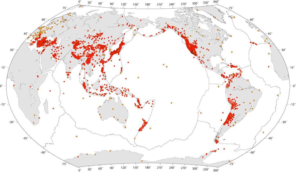
8 Since early 2000s, GPS has been effectively used to contribute in earthquake studies. The main product is the mm-size detection of the static displacements of a GPS receiver. GPS has since been appointed as a powerful tool to assess earthquake parameters (fault characteristics) and to contribute to early tsunami warnings. GPS seismology was effectively used to assess many recent global earthquakes (e.g., Alaska 2002 Mw 7.9, Chile 2010 Mw 8.8, California 2010 Mw 7.2). 8
9 9


 earthquakes,")
10 Ganas et al., JGeod.,2013 Valkaniotis S., Ganas A., Papathanassiou, G., and Papanikolaou M., Field observations of geological effects triggered by the January-February 2014 Cephalonia (Ionian Sea, Greece) earthquakes, Tectonophysics, DOI: /j.tecto
11 High-rate GPS is used to estimate in real-time the co-seismic displacement waveforms induced by an earthquake. It is the so-called GNSS seismology, which aims to exploit GPS to contribute in the estimation of important seismic parameters (e.g., seismic moment and moment magnitude ). In particular, some key features distinguish GPS with respect to other well-known seismological instruments (e.g., seismometers and accelerometers). Seismometers measure either velocities or accelerations and one needs to operate mathematical integration(s) to achieve the instrument positions. Instead, GPS now returns directly positions, which are essential to seismic assessment. 11
12 Denali (ALASKA): 3 November 2002, Mw=7.9 Displacement Time Series (1 Hz) K. Larson, GPS Seismology, J. Geod (2009), 83:
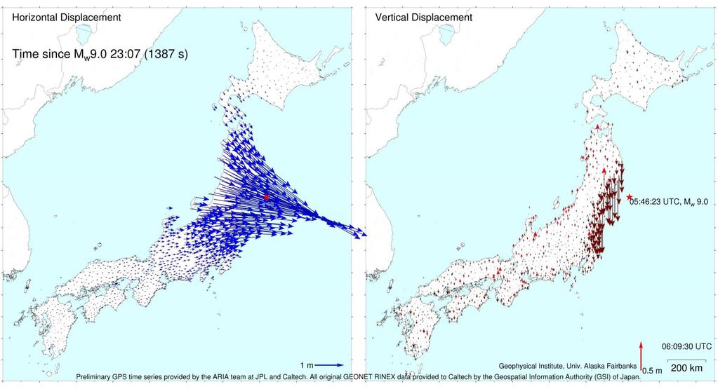
13 Secondly, the high energy released by strong earthquake can "blind" the acquisition capabilities of seismometers located in the vicinity (up to a km) of the epicentre in what is known as the saturation problem. Instead, even though GPS is less sensitive than seismometers, it does not saturate, not even for very strong earthquakes (e.g. Tohoku 2011) 13

14 following the EUREF (Regional Reference Frame Sub- Commission for Europe) Permanent Network standards 22 stations at 1-s 24/7 12 stations co-located at 1-10m with seismometers and strong-motion sensors 55 benchmarks 14

15 EPOS Database About 2200 cgnss stations, managed by 52 research infrastructures (RI), potentially available for EPOS 15
16 The PPP (Precise Point Positioning) processing technique is used to detect offsets in XYZ positions of GNSS stations in the Ionian Sea and Santorini Island, where tsunami hazard is high. PPP works on a single station, double-frequency, basis, continuously using the real-time RTCM v3.0 stream. PPP is a method to determine the exact coordinates of a single point using code or phase measurements with precise clocks and orbits. 16
17 Today, the PPP approach can contribute to GPS seismology with the aim of accurately estimating the displacements caused by an earthquake in realtime and using a single receiver with a few centimetres accuracy level. Simple transmission equipment can be added to allow communication if a defined displacement threshold is exceeded. With such a configuration, in case a large earthquake occurs, the displacements can be retrieved in realtime and immediately transmitted to a remote control centre, which can decide whether or not to raise a tsunami alert. We really hope that GNSS will provide an effective contribution to tsunami warning systems and that the possibility to work with low-cost receivers will lift up the application of GPS (and possibly of other GNSS like GLONASS (Russian), GALILEO (European) and Compass/Beidou (Chinese), in an interoperability framework) as an earthquake monitoring device. Thanks for your attention! 17
Trimble SG SeismoGeodetic For Earthquake Early Warning
 Trimble SG160-09 SeismoGeodetic For Earthquake Early Warning GeoSmart KL, Malaysia 1 ST October, 2015 TAN SIEW SIONG source: INTERNET Source: www.shakeout.govt.nz source: INTERNET CASE Studies Migration
GNSS (GPS) buoy array in the Pacific for natural disaster mitigation. Teruyuki KATO Earthquake Research Institute the University of Tokyo, Japan
 buoy array in the Pacific for natural disaster mitigation. Teruyuki KATO Earthquake Research Institute the University of Tokyo, Japan") GNSS (GPS) buoy array in the Pacific for natural disaster mitigation Teruyuki KATO Earthquake Research Institute the University of Tokyo, Japan 1 (Modified from Oki & Koketsu, 2011) Historical megaquakes
GNSS (GPS) buoy array in the Pacific for natural disaster mitigation Teruyuki KATO Earthquake Research Institute the University of Tokyo, Japan 1 (Modified from Oki & Koketsu, 2011) Historical megaquakes
Observing co-seismic displacements using 1-Hz data from a network of reference stations: a comparison of different data processing methods
 Observing co-seismic displacements using 1-Hz data from a network of reference stations: a comparison of different data processing methods Michail Gianniou National Cadastre and Mapping Agency S.A. Mesogion
The Promise and Challenges of Accurate Low Latency GNSS for Environmental Monitoring and Response
 Technical Seminar Reference Frame in Practice, The Promise and Challenges of Accurate Low Latency GNSS for Environmental Monitoring and Response John LaBrecque Geohazards Focus Area Global Geodetic Observing
Establishment of New Low-Cost and High-Resolution Real-Time Continuous Strong Motion Observation Network by CEORKA
 Establishment of New Low-Cost and High-Resolution Real-Time Continuous Strong Motion Observation Network by CEORKA T. Akazawa Geo-Research Institute, Japan M. Araki alab Inc., Japan S. Sawada & Y. Hayashi
Precise Positioning with Smartphones running Android 7 or later
 Precise Positioning with Smartphones running Android 7 or later * René Warnant, * Cécile Deprez, + Quentin Warnant * University of Liege Geodesy and GNSS + Augmenteo, Plaine Image, Lille (France) Belgian
Introduction to Total Station and GPS
 Introduction to Total Station and GPS Dr. P. NANJUNDASWAMY Professor of Civil Engineering J S S Science and Technology University S J College of Engineering Mysuru 570 006 Introduction History GPS Overview
GNSS buoy array in the ocean for natural hazard mitigation. Teruyuki KATO Earthquake Research Institute the University of Tokyo, Japan
 GNSS buoy array in the ocean for natural hazard mitigation Teruyuki KATO Earthquake Research Institute the University of Tokyo, Japan 1 GNSS applications in Earth science From static to high-rate observations
Strong Motion Data: Structures
 Strong Motion Data: Structures Adam Pascale Chief Technology Officer, Seismology Research Centre a division of ESS Earth Sciences Treasurer, Australian Earthquake Engineering Society Why monitor buildings?
National Report of Greece to EUREF 2014
 National Report of Greece to EUREF M. Gianniou, D. Mastoris, E. Mitropoulou National Cadastre and Mapping Agency S.A. Mesogion Ave., Athens, Greece. Introduction During the last months the main activities
GPS and Recent Alternatives for Localisation. Dr. Thierry Peynot Australian Centre for Field Robotics The University of Sydney
 GPS and Recent Alternatives for Localisation Dr. Thierry Peynot Australian Centre for Field Robotics The University of Sydney Global Positioning System (GPS) All-weather and continuous signal system designed
CONCEPT OF INTEGRATED CONTROL SYSTEM FOR MONITORING GEOMETRIC CHANGES OF THE TEMPORARY BRIDGE CROSSINGS
 CONCEPT OF INTEGRATED CONTROL SYSTEM FOR MONITORING GEOMETRIC CHANGES OF THE TEMPORARY BRIDGE CROSSINGS A. Bartnicki 1), J. Bogusz 2), G. Nykiel 2), M. Szołucha 2), M. Wrona 2) 1) Faculty of Mechanical
FieldGenius Technical Notes GPS Terminology
 FieldGenius Technical Notes GPS Terminology Almanac A set of Keplerian orbital parameters which allow the satellite positions to be predicted into the future. Ambiguity An integer value of the number of
What is a GPS How does GPS work? GPS Segments GPS P osition Position Position Accuracy Accuracy Accuracy GPS A pplications Applications Applications
 What is GPS? What is a GPS How does GPS work? GPS Segments GPS Position Accuracy GPS Applications What is GPS? The Global Positioning System (GPS) is a precise worldwide radio-navigation system, and consists
Originally published as:
 Originally published as: Li, X., Ge, M., Guo, B., Wickert, J., Schuh, H. (2013): Temporal point positioning approach for realtime GNSS seismology using a single receiver. Geophysical Research Letters,
RELEASE NOTES. Trimble Infrastructure GNSS Series Receivers. Introduction. New features or changes. Updating the firmware
 RELEASE NOTES Trimble Infrastructure GNSS Series Receivers Introduction New features or changes Updating the firmware Version 4.42 Revision A June 2011 F Corporate office Trimble Navigation Limited Engineering
The technical contribution of QZSS and GNSS to Tsunami early warning system
 0/17 Tsunami Workshop by Sentinel Asia @Sendai International Center Meeting Room 5 The technical contribution of QZSS and GNSS to Tsunami early warning system July 3, 2012 K. Mutoh, J. Yamashita, and S.
Low-cost densification of permanent GPS networks for natural hazard mitigation: First tests on GSI s GEONET network
 LETTER Earth Planets Space, 52, 867 871, 2000 Low-cost densification of permanent GPS networks for natural hazard mitigation: First tests on GSI s GEONET network Chris Rizos 1, Shaowei Han 1, Linlin Ge
Magnitude determination using duration of high frequency energy radiation for the 2011 Off the Pacific Coast of Tohoku Earthquake
 Magnitude determination using duration of high frequency energy radiation for the 2011 Off the Pacific Coast of Tohoku Earthquake Tatsuhiko Hara International Institute of Seismology and Earthquake Engineering
Introduction to Geographic Information Science. Last Lecture. Today s Outline. Geography 4103 / GNSS/GPS Technology
 Geography 4103 / 5103 Introduction to Geographic Information Science GNSS/GPS Technology Last Lecture Geoids Ellipsoid Datum Projection Basics Today s Outline GNSS technology How satellite based navigation
Earthquake Monitoring System Using Ranger Seismometer Sensor
 INTERNATIONAL JOURNAL OF GEOLOGY Issue, Volume, Earthquake Monitoring System Using Ranger Seismometer Sensor Iyad Aldasouqi and Adnan Shaout Abstract--As cities become larger and larger worldwide, earthquakes
Global Navigation Satellite Systems (GNSS): GPS, GLONASS, GALILEO
: GPS, GLONASS, GALILEO") Global Navigation Satellite Systems ():,, Dr Guergana Guerova Marie Curie Fellow Department of Meteorology and Geophysics Physics Faculty, Sofia University National Culture High School, 13 November 2012,
Global Navigation Satellite Systems ():,, Dr Guergana Guerova Marie Curie Fellow Department of Meteorology and Geophysics Physics Faculty, Sofia University National Culture High School, 13 November 2012,
VADASE Variometric Approach for Displacement Analysis Stand-alone Engine
 Department of Civil Engineering, Building and Environment Geodesy and Geomatics Area Ph.D. course Infrastructures and Transportations XXIV Ciclo VADASE Variometric Approach for Displacement Analysis Stand-alone
Real-Time and Multi-GNSS Key Projects of the International GNSS Service
 Real-Time and Multi-GNSS Key Projects of the International GNSS Service Urs Hugentobler, Chris Rizos, Mark Caissy, Georg Weber, Oliver Montenbruck, Ruth Neilan EUREF 2013 Symposium Budapest, Hungary, May
Name: Chengming Jin Supervisor: Allison Kealy. GNSS-based Positioning Scheme & Application in Safety-critical Systems of Rail Transport
 Name: Chengming Jin Supervisor: Allison Kealy GNSS-based Positioning Scheme & Application in Safety-critical Systems of Rail Transport CONTENT 1 Introduction 2 Challenges 3 Solutions Introduction How Modern
Developments on the EPOS-IP strain rate product
 Developments on the EPOS-IP strain rate product Athanassios Ganas, NOA, Greece, aganas@noa.gr Vasilis Kapetanidis, NOA-NKUA, Greece Faramarz Nilfouroushan, LM, Gävle, Sweden, University of Gävle, Sweden
European Position Determination System. Technical Standards
 European Position Determination System Technical Standards Revised 2 nd Edition 24 April 2008 Resolution of the International EUPOS Steering Committee 13 th Conference, Bucharest, Romania, 23 24 April
Identification of High Frequency pulse from Earthquake asperities along Chilean subduction zone using strong motion
 Identification of High Frequency pulse from Earthquake asperities along Chilean subduction zone using strong motion S. Ruiz 1,2, E. Kausel 1, J. Campos 1, R. Saragoni 1 and R. Madariaga 2. 1 University
Global Navigation Satellite Systems (GNSS): GPS, GLONASS, GALILEO
: GPS, GLONASS, GALILEO") Global Navigation Satellite Systems ():,, Dr Guergana Guerova Marie Curie Fellow Department of Meteorology and Geophysics Physics Faculty, Sofia University Actual topics in the modern physics, Sofia University,
Global Navigation Satellite Systems ():,, Dr Guergana Guerova Marie Curie Fellow Department of Meteorology and Geophysics Physics Faculty, Sofia University Actual topics in the modern physics, Sofia University,
KEYWORDS Earthquakes; MEMS seismic stations; trigger data; warning time delays. Page 144
 Event Detection Time Delays from Community Earthquake Early Warning System Experimental Seismic Stations implemented in South Western Tanzania Between August 2012 and December 2013 Asinta Manyele 1, Alfred
Engineering Project Proposals
 Engineering Project Proposals (Wireless sensor networks) Group members Hamdi Roumani Douglas Stamp Patrick Tayao Tyson J Hamilton (cs233017) (cs233199) (cs232039) (cs231144) Contact Information Email:
Evaluation of Multi-Constellation GNSS Precise Point Positioning (PPP) Techniques in Egypt
 Techniques in Egypt") Evaluation of Multi-Constellation GNSS Precise Point Positioning (PPP) Techniques in Egypt Mahmoud Abd Rabbou and Adel El-Shazly Department of Civil Engineering, Cairo University Presented by; Dr. Mahmoud
Evaluation of Multi-Constellation GNSS Precise Point Positioning (PPP) Techniques in Egypt Mahmoud Abd Rabbou and Adel El-Shazly Department of Civil Engineering, Cairo University Presented by; Dr. Mahmoud
Trimble NetR9 Reference Receiver Series: Frequently Asked Questions
 July 2010 Trimble NetR9 Reference Receiver Series: Frequently Asked Questions What is the Trimble NetR9 GNSS reference receiver? The Trimble NetR9 GNSS (Global Navigation Satellite System) reference receiver
Federico MORSUT 1, Raffaela CEFALO 2. DMG, University of Trieste; 2 GeoSNav Lab, University of Trieste
 Comparison between PPP and DD processing techniques using Bernese 5.2 Computation of displacements and velocities of Marussi FVG and FredNet GNSS networks and visualization on GeoServer: first results
28th Seismic Research Review: Ground-Based Nuclear Explosion Monitoring Technologies SEL0: A FAST PROTOTYPE BULLETIN PRODUCTION PIPELINE AT THE CTBTO
 SEL0: A FAST PROTOTYPE BULLETIN PRODUCTION PIPELINE AT THE CTBTO Ronan J. Le Bras 1, Tim Hampton 1, John Coyne 1, and Alexander Boresch 2 Provisional Technical Secretariat of the Preparatory Commission
EPOS research infrastructure (European Plate Observing System)
") EPOS research infrastructure (European Plate Observing System) and its potential to improve our knowledge of the deformation of the Alps Anne Socquet et al. VAO symposium, March 15th, 2018 Motivation Earth
EPOS research infrastructure (European Plate Observing System) and its potential to improve our knowledge of the deformation of the Alps Anne Socquet et al. VAO symposium, March 15th, 2018 Motivation Earth
GNSS & Coordinate Systems
 GNSS & Coordinate Systems Matthew McAdam, Marcelo Santos University of New Brunswick, Department of Geodesy and Geomatics Engineering, Fredericton, NB May 29, 2012 Santos, 2004 msantos@unb.ca 1 GNSS GNSS
Software Defined Receivers in GNSS scientific applications: variometric approach to exploit GNSS-SDR phase observations
 Software Defined Receivers in GNSS scientific applications: variometric approach to exploit GNSS-SDR phase observations Mara Branzanti 1, Javier Arribas 2, Carles Fernandez-Prades 2, Mattia Giovanni Crespi
Evaluating the Integrability of the Quake-Catcher
 Evaluating the Integrability of the Quake-Catcher Network (QCN) Angela I Chung aichung@stanford.edu Carl Christensen carlgt1@yahoo.com Jesse F. Lawrence jflawrence@stanford.edu ABSTRACT This paper reviews
UNAVCO's Community Planning for real-time GPS in Earthscope's Plate Boundary Observatory
 Click to edit Master slide title UNAVCO's Community Planning for real-time GPS in Earthscope's Plate Boundary Observatory Chuck Meertens (presenting Author) David Mencin William Hammond John Langbein Bob
EUREF Permanent GNSS Network Carine Royal Observatory of Belgium
 ENEON first workshop Observing Europe: Networking the Earth Observation Networks in Europe EUREF Permanent GNSS Network Carine Bruyninx/C.Bruyninx@oma.be Royal Observatory of Belgium 1. About your network
Innovation and Experience in GNSS Bridge Real Time 3D- Monitoring System
 Innovation and Experience in GNSS Bridge Real Time 3D- Monitoring System Joël van Cranenbroeck, Managing Director CGEOS Creative GeoSensing sprl-s Rue du Tienne de Mont, 11 5530 MONT, Belgium Transportation
Challenges and Solutions for GPS Receiver Test
 Challenges and Solutions for GPS Receiver Test Presenter: Mirin Lew January 28, 2010 Agenda GPS technology concepts GPS and GNSS overview Assisted GPS (A-GPS) Basic tests required for GPS receiver verification
Real-time Earthquake and Tsunami Early Warning System
 Real-time Earthquake and Tsunami Early Warning System Dr. Gerald Bawden NASA Mike Angove, Dr. Charles McCreery, Dr. Paul Huang NOAA Dr. Timothy Melbourne Central Washington University Dr. Yehuda Bock UC
Development of Venus Balloon Seismology Missions through Earth Analog Experiments
 Development of Venus Balloon Seismology Missions through Earth Analog Experiments Venus Exploration Analysis Group (VEXAG) Meeting November 14-16, 2017 Siddharth Krishnamoorthy, Attila Komjathy, James
Update on the International Terrestrial Reference Frame (ITRF)
") Update on the International Terrestrial Reference Frame (ITRF) Zuheir Altamimi Head of the IERS ITRF Product Center Institut National de l Information Géographique et Forestière IGN, France E-mail: zuheir.altamimi@ign.fr
Update on the International Terrestrial Reference Frame (ITRF) Zuheir Altamimi Head of the IERS ITRF Product Center Institut National de l Information Géographique et Forestière IGN, France E-mail: zuheir.altamimi@ign.fr
One Source for Positioning Success
 novatel.com One Source for Positioning Success RTK, PPP, SBAS OR DGNSS. NOVATEL CORRECT OPTIMIZES ALL CORRECTION SOURCES, PUTTING MORE POWER, FLEXIBILITY AND CONTROL IN YOUR HANDS. NovAtel CORRECT is the
GNSS Programme. Overview and Status in Europe
 GNSS Programme Overview and Status in Europe Inaugural Forum Satellite Positioning Research and Application Center 23 April 2007 Tokyo Presented by Thomas Naecke (European Commission) Prepared by Daniel
King AbdulAziz University. Faculty of Environmental Design. Geomatics Department. Mobile GIS GEOM 427. Lecture 3
 King AbdulAziz University Faculty of Environmental Design Geomatics Department Mobile GIS GEOM 427 Lecture 3 Ahmed Baik, Ph.D. Email: abaik@kau.edu.sa Eng. Fisal Basheeh Email: fbasaheeh@kau.edu.sa GNSS
The International Scene: How Precise Positioning Will Underpin Critical GNSS Applications
 The International Scene: How Precise Positioning Will Underpin Critical GNSS Applications School of Civil & Environmental Engineering, UNSW, Sydney, Australia Chris Rizos Member of the IGS Governing Board
Inertial Sensors. Ellipse Series MINIATURE HIGH PERFORMANCE. Navigation, Motion & Heave Sensing IMU AHRS MRU INS VG
 Ellipse Series MINIATURE HIGH PERFORMANCE Inertial Sensors IMU AHRS MRU INS VG ITAR Free 0.1 RMS Navigation, Motion & Heave Sensing ELLIPSE SERIES sets up new standard for miniature and cost-effective
Sidereal Filtering for Multi-GNSS Precise Point Positioning and Deformation Monitoring
 Sidereal Filtering for Multi-GNSS Precise Point Positioning and Deformation Monitoring Philippa Catherine Cowles Thesis submitted for the Degree of Doctor of Philosophy School of Civil Engineering and
Performance Evaluation Of Real Time Precise Point Positioning (RT-PPP) In Static & Kinematic Modes In Egypt
 In Static & Kinematic Modes In Egypt") Performance Evaluation Of Real Time Precise Point Positioning (RT-PPP) In Static & Kinematic Modes In Egypt Eng. Ahmed Mansour Abdallah Dr. Mahmoud Abd Rabbou Prof. Adel El.shazly Geomatic Branch, Civil
Performance Evaluation Of Real Time Precise Point Positioning (RT-PPP) In Static & Kinematic Modes In Egypt Eng. Ahmed Mansour Abdallah Dr. Mahmoud Abd Rabbou Prof. Adel El.shazly Geomatic Branch, Civil
USING AUTHOR S GNSS RTK MEASURMENT SYSTEM FOR INVESTIGATION OF DISPLACEMENT PARAMETERS OF STRUCTURE
 USING AUTHOR S GNSS RTK MEASURMENT SYSTEM FOR INVESTIGATION OF DISPLACEMENT PARAMETERS OF STRUCTURE M. Figurski, M. Wrona, G. Nykiel Center of Applied Geomatics Military University of Technology 2 Kaliskiego
Advances in Planetary Seismology Using Infrasound and Airglow Signatures on Venus
 Advances in Planetary Seismology Using Infrasound and Airglow Signatures on Venus 1 Attila Komjathy, 1 Siddharth Krishnamoorthy 1 James Cutts, 1 Michael Pauken,, 1 Sharon Kedar, 1 Suzanne Smrekar, 1 Jeff
Wednesday AM: (Doug) 2. PS and Long Period Signals
 2. PS and Long Period Signals") Wednesday AM: (Doug) 2 PS and Long Period Signals What is Colorado famous for? 32 satellites 12 Early on in the world of science synchronization of clocks was found to be important. consider Paris: puffs
Wednesday AM: (Doug) 2 PS and Long Period Signals What is Colorado famous for? 32 satellites 12 Early on in the world of science synchronization of clocks was found to be important. consider Paris: puffs
Experiences with Fugro's Real Time GPS/GLONASS Orbit/Clock Decimeter Level Precise Positioning System
 Return to Session Directory DYNAMIC POSITIONING CONFERENCE October 13-14, 2009 Sensors Experiences with Fugro's Real Time GPS/GLONASS Orbit/Clock Decimeter Level Precise Positioning System Ole Ørpen and
Future of Reference Frames from Static to Dynamic? Markku Poutanen and Pasi Häkli
 Future of Reference Frames from Static to Dynamic? Markku Poutanen and Pasi Häkli Finnish Geospatial Research Institute, FGI Future of Reference Frames from Static to Dynamic? kinematic Markku Poutanen
The realization of a 3D Reference System
 The realization of a 3D Reference System Standard techniques: topographic surveying and GNSS Observe angles and distances either between points on the Earth surface or to satellites and stars. Do not observe
Understanding GPS/GNSS
 Understanding GPS/GNSS Principles and Applications Third Edition Contents Preface to the Third Edition Third Edition Acknowledgments xix xxi CHAPTER 1 Introduction 1 1.1 Introduction 1 1.2 GNSS Overview
Precise Positioning GNSS Applications
 Precise Point Positioning: Is the Era of Differential GNSS Positioning Drawing to an End? School of Surveying & Spatial Information Systems, UNSW, Sydney, Australia Chris Rizos 1, Volker Janssen 2, Craig
Performance Evaluation of Differential Global Navigation Satellite System with RTK Corrections
 IOSR Journal of Electronics and Communication Engineering (IOSR-JECE) e-issn: 2278-2834,p- ISSN: 2278-8735.Volume 9, Issue 2, Ver. VI (Mar - Apr. 2014), PP 43-47 Performance Evaluation of Differential
GLOBAL POSITIONING SYSTEMS
 GLOBAL POSITIONING SYSTEMS GPS & GIS Fall 2017 Global Positioning Systems GPS is a general term for the navigation system consisting of 24-32 satellites orbiting the Earth, broadcasting data that allows
Galileo - European Global Navigation Satellite System
 Abstract Galileo - European Global Navigation Satellite System Wu Chen Department of Land Surveying and Geoinformatics Hong Kong Polytechnic University e-mail: Lswuchen@polyu.du.hk Washington Yotto Ochieng
MAGICGNSS RTCM-BASED SERVICE, A LEAP FORWARD TOWARDS MULTI- GNSS HIGH ACCURACY REAL-TIME PROCESSING
 ION GNSS 2015 MAGICGNSS RTCM-BASED SERVICE, A LEAP FORWARD TOWARDS MULTI- GNSS HIGH ACCURACY REAL-TIME PROCESSING SEPTEMBER 16 TH, 2015 - ION GNSS 2015, TAMPA, FLORIDA, USA SESSION E2A: NEXT GENERATION
Fast convergence of Trimble CenterPoint RTX by regional augmentation
 Fast convergence of Trimble CenterPoint RTX by regional augmentation Dr. Ralf Drescher Trimble Terrasat GmbH, Munich EGU General Assembly 2015, Vienna Thursday, 16 April 2015 Outline Introduction CenterPoint
Recent Advances to Obtain Real - time Displacements for Engineering Applications
 Recent Advances to Obtain Real - time Displacements for Engineering Applications Mehmet Çelebi USGS (MS977), 345 Middlefield Rd., Menlo Park, Ca. 945 Abstract This paper presents recent developments and
Next Generation Positioning Infrastructure
 Next Generation Positioning Infrastructure The GNSS Network in the 21 st Century Joel VAN CRANENBROECK & Partners Beyond East & West GeoSensing Community 1 INFRASTRUCTURE "The installations that form the
GEONET -CORS Network of japan-
 GEONET -CORS Network of japan- Basara Miyahara Geospatial Information Authority of Japan Geospatial and GNSS CORS Infrastructure Forum Kuala Lumpur - Malaysia Geospatial Information Authority of Japan
Proposed standard for permanent GNSS reference stations in the Nordic countries
 Version 0.6 2003-05-15 Proposed standard for permanent GNSS reference stations in the Nordic countries Introduction Subproject A0 of the project Nordic Real-time Positioning Service Gunnar Hedling, Finn
RAPID MAGITUDE DETERMINATION FOR TSUNAMI WARNING USING LOCAL DATA IN AND AROUND NICARAGUA
 RAPID MAGITUDE DETERMINATION FOR TSUNAMI WARNING USING LOCAL DATA IN AND AROUND NICARAGUA Domingo Jose NAMENDI MARTINEZ MEE16721 Supervisor: Akio KATSUMATA ABSTRACT The rapid magnitude determination of
National Report of Greece to EUREF 2009
 National Report of Greece to EUREF 2009 M. Gianniou KTIMATOLOGIO S.A. (Hellenic Cadastre) 1 Introduction In 2007, KTIMATOLOGIO S.A (Hellenic Cadastre) established HEPOS, the HEllenic POsitioning System,
Bernhard Hofnlann-Wellenhof Herbert Lichtenegger Elmar Wasle. GNSS - Global Navigation Satellite Systenls. GPS, GLONASS, Galileo, and nl0re
 Bernhard Hofnlann-Wellenhof Herbert Lichtenegger Elmar Wasle GNSS - Global Navigation Satellite Systenls GPS, GLONASS, Galileo, and nl0re SpringerWienNewYork Contents Abbreviations xxi 1 Introduction 1
SERVIR: The Portuguese Army CORS Network for RTK
 SERVIR: The Portuguese Army CORS Network for RTK António Jaime Gago AFONSO, Rui Francisco da Silva TEODORO and Virgílio Brito MENDES, Portugal Key words: GNSS, RTK, VRS, Network ABSTRACT Traditionally
MINIMUS MINIMUS+ SMART SEISMIC DIGITISER WITH ADVANCED DATA-PROCESSING CAPABILITY AND SOFTWARE COMMUNICATIONS
 MINIMUS MINIMUS+ SMART SEISMIC DIGITISER WITH ADVANCED DATA-PROCESSING CAPABILITY AND SOFTWARE COMMUNICATIONS KEY FEATURES > > Advanced software communications for quick and easy instrument and data management
Global Correction Services for GNSS
 Global Correction Services for GNSS Hemisphere GNSS Whitepaper September 5, 2015 Overview Since the early days of GPS, new industries emerged while existing industries evolved to use position data in real-time.
Global and Regional Real-Time Infrastructure for open access use
 Global and Regional Real-Time Infrastructure for open access use Axel Rülke Federal Agency for Cartography and Geodesy Branch Office Leipzig, Germany Tutorial on (Open) Real-Time Infrastructure and Applications
RESOLUTION MSC.401(95) (Adopted on 8 June 2015) PERFORMANCE STANDARDS FOR MULTI-SYSTEM SHIPBORNE RADIONAVIGATION RECEIVERS
 (Adopted on 8 June 2015) PERFORMANCE STANDARDS FOR MULTI-SYSTEM SHIPBORNE RADIONAVIGATION RECEIVERS") ANNEX 17 MSC 95/22/Add.2 Annex 17, page 1 THE MARITIME SAFETY COMMITTEE, RECALLING Article 28(b) of the Convention on the International Maritime Organization concerning the functions of the Committee,
ANNEX 17 MSC 95/22/Add.2 Annex 17, page 1 THE MARITIME SAFETY COMMITTEE, RECALLING Article 28(b) of the Convention on the International Maritime Organization concerning the functions of the Committee,
GNSS Modernisation and Its Effect on Surveying
 Lawrence LAU and Gethin ROBERTS, China/UK Key words: GNSS Modernisation, Multipath Effect SUMMARY GPS and GLONASS modernisation is being undertaken. The current GPS modernisation plan is expected to be
Evaluation of RTKLIB's Positioning Accuracy Using low-cost GNSS Receiver and ASG-EUPOS
 http://www.transnav.eu the International Journal on Marine Navigation and Safety of Sea Transportation Volume 7 Number 1 March 2013 DOI: 10.12716/1001.07.01.10 Evaluation of RTKLIB's Positioning Accuracy
GNSS Accuracy Improvements through Multipath Mitigation with New Signals and services
 GNSS Accuracy Improvements through Multipath Mitigation with New Signals and services Andrey Veytsel, Ph.D Moscow Technical University 10 Meeting of the International Committee on Global Navigation Satellite
What is GPS? GPS Position Accuracy. GPS Applications. What is a GPS. How does GPS work? GPS Segments
 What is GPS? What is a GPS How does GPS work? GPS Segments GPS Position Accuracy GPS Applications 1 What is GPS? The Global Positioning System (GPS) is a precise worldwide radio-navigation system, and
Relative positioning with Galileo E5 AltBOC code measurements
 Relative positioning with Galileo E5 AltBOC code measurements Dissertation submitted to the University of Liège in requirements for a Master s degree in Geomatics and Geometrology Cécile Deprez PhD Candidate
A GLONASS Observation Message Compatible With The Compact Measurement Record Format
 A GLONASS Observation Message Compatible With The Compact Measurement Record Format Leica Geosystems AG 1 Introduction Real-time kinematic (RTK) Global Navigation Satellite System (GNSS) positioning has
EUPOS European Position Determination System
 EUPOS European Position Determination System c/o Senate Department for Urban Development, State Berlin, Germany Umea, Sweden, 22 nd 23 rd 2011 The Geodetic Infrastructure in Europe today and tomorrow Slide
Real-time PPP Results From Global Orbit and Clock Corrections
 BKG, Frankfurt a.m. Real-time PPP Results From Global Orbit and Clock Corrections Yüksel Altiner 1, Leos Mervart 2, Peter Neumaier 1, Wolfgang Söhne 1, Georg Weber 1 1 Federal Agency for Cartography and
ISTANBUL EARTHQUAKE RAPID RESPONSE AND THE EARLY WARNING SYSTEM. M. Erdik Department of Earthquake Engineering aziçi University,, Istanbul
 ISTANBUL EARTHQUAKE RAPID RESPONSE AND THE EARLY WARNING SYSTEM M. Erdik Department of Earthquake Engineering Boğazi aziçi University,, Istanbul ISTANBUL THREATENED BY MAIN MARMARA FAULT ROBABILITY OF
The Mid-term Review of the European Satellite Radio Navigation Programmes Galileo and EGNOS: Questions and Answers
 MEMO/11/26 Brussels, 18 th January 2011 The Mid-term Review of the European Satellite Radio Navigation Programmes Galileo and EGNOS: Questions and Answers See also IP/11/42 For the full text of the Communication
Global Positioning Systems (GPS) Trails: the achilles heel of mapping from the air / satellites
 Trails: the achilles heel of mapping from the air / satellites") Global Positioning Systems (GPS) Trails: the achilles heel of mapping from the air / satellites Google maps updated regularly by local users using GPS Also: http://openstreetmaps.org GPS applications
Global Positioning Systems (GPS) Trails: the achilles heel of mapping from the air / satellites Google maps updated regularly by local users using GPS Also: http://openstreetmaps.org GPS applications
Station. Accelerogram Station Accelerogram
 RECORD PROCESSING METHODS AND PROCEDURES FOR THE MEXICAN STRONG MOTION PROGRAM Leonardo Alcántara N Citlali Pérez Y Engineering Institute, National Autonomous University of Mexico (UNAM) Main seismic events
Satellite Navigation (and positioning)
") Satellite Navigation (and positioning) Picture: ESA AE4E08 Instructors: Sandra Verhagen, Hans van der Marel, Christian Tiberius Course 2010 2011, lecture 1 Today s topics Course organisation Course contents
Satellite Navigation (and positioning) Picture: ESA AE4E08 Instructors: Sandra Verhagen, Hans van der Marel, Christian Tiberius Course 2010 2011, lecture 1 Today s topics Course organisation Course contents
Applications, Products and Services of GPS Technology
 Applications, Products and Services of GPS Technology Enrico C. Paringit. Dr. Eng. University of the Philippines Training Center for Applied Geodesy and Photogrammetry 1 Outline of this Presentation GPS
Sounding the Atmosphere Ground Support for GNSS Radio-Occultation Processing
 Sounding the Atmosphere Ground Support for GNSS Radio-Occultation Processing Atmospheric Sounding René Zandbergen & John M. Dow Navigation Support Office, Ground Systems Engineering Department, Directorate
New Approach for Tsunami Detection Based on RTK-GNSS Using Network of Ships
 New Approach for Tsunami Detection Based on RTK-GNSS Using Network of Ships Tokyo University of Marine Science and Technology Ryuta Nakaosone Nobuaki Kubo Background After the Indian Ocean Tsunami on 2004,
The European Satellite Radio Navigation Programmes Galileo and EGNOS: Questions and Answers
 MEMO/11/326 Brussels, 23 May 2011 The European Satellite Radio Navigation Programmes Galileo and EGNOS: Questions and Answers What is satellite navigation? Satellite navigation is based on the principle
An inventory of collocated and nearly-collocated CGPS stations and tide gauges
 1 sur 6 An inventory of collocated and nearly-collocated CGPS stations and tide gauges Progress report on the survey - (July 25, 2007) - by Guy Wöppelmann, Thorkild Aarup, and Tilo Schoene Note : The dynamic
Positioning Techniques. João F. Galera Monico - UNESP Tuesday 12 Sep
 Positioning Techniques João F. Galera Monico - UNESP Tuesday 12 Sep Positioning methods Absolute Positioning Static and kinematic SPP and PPP Relative Positioning Static Static rapid Semi kinematic Kinematic
APPLICATIONS OF GPS. The Global Positioning System, while originally a military project, is considered a
 APPLICATIONS OF GPS Applications The Global Positioning System, while originally a military project, is considered a dual-use technology, meaning it has significant applications for both the military and
08/10/2013. Marine Positioning Systems Surface and Underwater Positioning. egm502 seafloor mapping
 egm502 seafloor mapping lecture 8 navigation and positioning Marine Positioning Systems Surface and Underwater Positioning All observations at sea need to be related to a geographical position. To precisely
Resection. We can measure direction in the real world! Lecture 10: Position Determination. Resection Example: Isola, Slovenia. Professor Keith Clarke
 Geography 12: Maps and Spatial Reasoning Lecture 10: Position Determination We can measure direction in the real world! Professor Keith Clarke Resection Resection Example: Isola, Slovenia Back azimuth