The realization of a 3D Reference System
|
|
|
- Suzanna Carson
- 6 years ago
- Views:
Transcription
1 The realization of a 3D Reference System Standard techniques: topographic surveying and GNSS Observe angles and distances either between points on the Earth surface or to satellites and stars. Do not observe positions with respect to the geocenter, the rotation axis and the reference meridian.
2 RSs must be realized by networks of benchmarks or continuously monitored stations, whose coordinates are: estimated in the RS, published in catalogues. Then, local networks can be estimated by standard techniques wrt these reference networks. System: the geometric definition Frame: the realization, i.e. the catalogue of the coordinates of a set of points that provide the reference (frame) to estimate the positions of other points.
3 For historical reasons and applications different definitions: different Reference Systems. Given a unique System, for practical reasons: different observations campaigns: different Frames.
4 Reference Frames They can be classified in Global RFs Realized by global networks of fundamental points that cover the whole planet by satellite geodesy techniques (VLBI, SLR, GPS) to estimate positions, displacements and deformations (geodynamics) of the planet.
5 Local RFs Defined at the local scale (continental, national,, structure control) by: At the scale of the continents/nations, 1. GPS networks adjusted in the global network, 2. horizontal and vertical national networks (historical topographic/cartographic/cadastral). At the local scale GPS/topographic network for surveying and monitoring.
6 Continuously monitored RFs Realized by networks of continuously observing stations, whose coordinates are continuously estimated: permanent stations and networks. Static RFs Realized by benchmarks surveyed and estimated in a single campaign.
7 Note Continuously monitored RFs guarantee the maximum consistence, because at each epoch, the distributed coordinates are consistent with the accuracy of the measurement/estimation methods. Static RFs provide crystallized coordinates; even if they had been surveyed with the maximum accuracy, their errors grow in time because of local phenomena (breaks, maintenance works,...) and regional deformations (subsidence, geodynamics,...).


8 A permanent GNSS station A H24 operating GNSS receiver publishes raw data is continuously monitored, provides its coordinate estimates. In Figure: Como PS.
9 Permanent networks A permanent network consists of: 1. a set of permanent stations, with a homogeneous spatial distribution in the interested area. 2. one or more control centers that: manage the PSs, check their data quality, process the network data, estimate PSs coordinates, if needed, distribute network data and products to the users.
10 PNs aims The aims of a PN can be different: global reference frame (IGS) monitoring, local reference frame (EPN) monitoring, local control: alpine geodynamics, landslides, dams,... positioning services: GPS users supporting at different latency and accuracy scales.
11 International Terrestrial Reference System Geocentric Unit of length: meter, consistent with the TCG scale. Initial axis orientation: BIH 1984 orientation. Time evolution of the axes orientation: no net rotation with respect to the Earth tectonics
12 ITRS Permanent networks Four spatial geodesy techniques: VLBI: Very Long Baseline Interferometry SLR: Satellite Laser Ranging DORIS: Doppler Orbit determination and Radiopositioning Integrated on Satellite GNSS. Global Navigation Satellite Systems (GPS+GLONASS+GALILEO+...)

13 The global VLBI network (International VLBI Service) About 30 stations, implemented by space telescopes.

14 The global SLR network (International SLR Service) About 90 stations, by laser telescope.
15 The global GNSS network: International GNSS Service A IAG service, established in 1993, with the following goals: to contribute to the realization and distribution of ITRS; to distribute GNSS products (ephemerides, EOP, ); to define the standards for GNSS permanent networks; to support GNSS research. About 470 PSs. several Analysis centres, Working groups, Pilot projects, Services, a Central Bureau.

16 The IGS PN
17 ITRF (ITR Frame) by IERS From 1988 the results provided by VLBI, SLR, GPS are analyzed by the IERS (International Earth Rotation Service), with the following estimation goals: Earth Orientation Parameters (EOP), International Celestial Reference Frame, International Terrestrial Reference Frame, tectonics of the Earth crust.
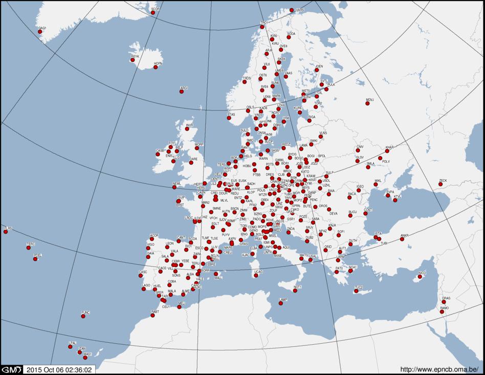
18 ITRF The number of PS s (VLBI, SLR, GPS) increase; the estimation algorithms improve. ITRF (coordinates catalogues) evolves with one update about every 5 years: the main are ITRF89,, ITRF2005, ITRF2008.
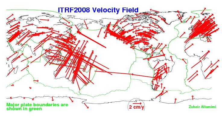
19 A ITRF consists of a catalogue of coordinates and velocities of the PS s contributing to the solution. In the map: ITRF2008 PSs.
20 Estimation and distribution of ITRF VLBI: quasar observations link Earth rotation to celestial rerence frame provides earth orientation parameters estimates the Z axis of ITRF SLR: satellites orbits estimation allows to estimate the geocenter estimates the origin of ITRF IGS PN is linked to VLBI and SLR and distributes ITRF to the GNSS user community
21 Distributed estimates for each PS Initial geocentric position x ( t0) and related covariance C, 00 velocity!x and related covariance C vv for the reference epoch t 0. ITRF2008 estimates for some Italian GPS PS s Nome Xm ( ) Ym ( ) Zm ( )!X (m / y) Y(m! / y) Z(m! / y) Bolzano Matera Cagliari
22 The coordinates can be propagated at each epoch t t by the 0 x(t) = x(t 0 ) +!x (t t 0 ), C() t = C + C ( t t ) 00 vv 0 2 Characteristics of ITRF Accuracies of the last ITRFs are of some mm. a low update rate (each about 5 years), the linear hypothesis on the PSs velocities can be too much rigid.
23
24 Cartographic applications and regional RFs Earth crust is moving: each geodetic point moves Given a region, global movements should be removed for local positioning, then 1. cartographic purposes: typically at the continental/national scale 2. local monitoring of inner deformations: local geodynamics, landslides,... Local reference frames are useful/defined in these cases.
25 The European Terrestrial Reference System , ETRS89 ETRS89 coincides with ITRS in , but moves and rotates with the stable (mean) part of Europe. Realized by the IAG European Reference Frame (EUREF) Commission, by EPN. EPN (European Permanent Network) About 275 GNSS PSs
26
27 Present realization: ETRF2000-R08 ITRF coordinates and velocities of EPN stations are estimated, the transformation parameters between ITRF and ETRF are published and distributed, ETRF coordinates and velocities of the stations are computed by applying the transformations. ETRF2000 provides a RF with minimum motion wrt Europe: useful for all the cartographic applications.

28 EPN Webpage of COMO PS

29 COMO displacement in ETRF
30 Transformation of ITRF results to ETRF ITRF coordinates are transformed to ETRF at epoch t, by: x(t) P,E = t(t) + (1+ µ(t))x(t) P,I + δ R(t)x(t) P,I δ R(t) = r 0 + (t )!r, t(t) = t 0 + (t )!t, µ(t) = µ 0 + (t )!µ The mean motion of the Europe from to the current epoch is subtracted (the motion from to is embedded in constant parameters; the motion from 2000 to current epoch is given by annual rates).
31 Transformation parameters and their rates are given by official EUREF documents

32 All the transformations are now implemented in EPN webpage.
33 The Italian (static) realization of ETRF: IGM95 The national geodetic network, monumented and surveyed by Istituto Geografico Militare Italiano (IGM) is called IGM95. IGM95 is composed of about 1250 benchmarks.

")
34 Example of IGM95 monograph (Lentate)
35 First IGM95 adjustment In the 90, in ETRF89 at epoch Problems: deformations and errors due to survey instruments and techniques, data elaboration algorithms, adjustment constraints, less accurate in 90 than now. Errors: in horizontal up to 5 cm, in heights up to 10 cm, sparse larger blunders.
.")
36 The new national network and the adjustment of IGM95 Dynamic National Network (RDN). A PN of 99 PSs to establish the new national zero order network.
37 In RDN (one month of data) has been adjusted in ITRF2005. Coordinates have been transformed to ETRF2000 IGM95 has been linked ( 45 baselines) to RDN and adjusted in ETRF2000. New IGM95 monographs report updated ETRF2000 coordinates.
38 RF fixing in GNSS positioning Two cases: point positioning & relative positioning / network adjustment Point positioning In point positioning, the RF is imposed by fixing the satellite coordinates Relative positioning Baselines estimation and network graph
39 Relative positioning A local geodetic 3D net surveyed by GNSS is a network of baselines A 3D translation must be fixed
40 Cheap approach to minimal constraints One (reference) point of known x P coordinates included in the network: its a priori coordinates are fixed in the adjustment. An error in the reference point completely propagates into the whole network.
41 Optimal approach to minimal constraints (adjustment of the network) Include several reference points in the network. The local network is adjusted in a network of higher order.
42 Optimal approach to minimal constraints The barycenter of the a priori coordinates of the reference stations x Ri is computed by the x = x 0, R 0 Ri, i the barycenter is kept fixed in the adjustment xˆ = x xˆ x = ξˆ = 0 Ri, 0 Ri, Ri, 0 Ri, Ri, i i i i
43 Guidelines to adjust a local network in IGS / EPN Some PSs from IGS/EPN are included in the local network, their raw data are downloaded by public EPN/IGS ftp sites and processed with the local network data, their IGS / EPN coordinates are computed at the campaign epoch t by the linear propagation of official coordinates and velocities and are (minimally) constrained in the adjustment of the local network. The network coordinates are 'aligned' to ITRF / ETRF at epoch t
44 The praxis to adjust a local network in IGM95 Some benchmarks of IGM95 are included in the local network, they must be occupied by receivers and processed with the local network data, their coordinates are (minimally) constrained to the monographs values in the adjustment of the local network. The network coordinates are estimated in IGM95. The praxis is less accurate than the ITRF/ETRF procedure: it should be adopted only for cadastral and topographic surveying.
Reference Systems: Definition and Realization Associated IAG Services IAG Reference Frame Sub-commission for Europe (EUREF)
") Reference Systems: Definition and Realization Associated IAG Services IAG Reference Frame Sub-commission for Europe (EUREF) Zuheir ALTAMIMI Laboratoire de Recherche en Géodésie Institut Géographique National
Reference Systems: Definition and Realization Associated IAG Services IAG Reference Frame Sub-commission for Europe (EUREF) Zuheir ALTAMIMI Laboratoire de Recherche en Géodésie Institut Géographique National
Geodetic Reference Frame Theory
 Technical Seminar Reference Frame in Practice, Geodetic Reference Frame Theory and the practical benefits of data sharing Geoffrey Blewitt University of Nevada, Reno, USA http://geodesy.unr.edu Sponsors:
Applications, Products and Services of GPS Technology
 Applications, Products and Services of GPS Technology Enrico C. Paringit. Dr. Eng. University of the Philippines Training Center for Applied Geodesy and Photogrammetry 1 Outline of this Presentation GPS
GPS for crustal deformation studies. May 7, 2009
 GPS for crustal deformation studies May 7, 2009 High precision GPS for Geodesy Use precise orbit products (e.g., IGS or JPL) Use specialized modeling software GAMIT/GLOBK GIPSY OASIS BERNESE These software
IAG School on Reference Systems June 7 June 12, 2010 Aegean University, Department of Geography Mytilene, Lesvos Island, Greece SCHOOL PROGRAM
 IAG School on Reference Systems June 7 June 12, 2010 Aegean University, Department of Geography Mytilene, Lesvos Island, Greece SCHOOL PROGRAM Monday June 7 8:00-9:00 Registration 9:00-10:00 Opening Session
Future of Reference Frames from Static to Dynamic? Markku Poutanen and Pasi Häkli
 Future of Reference Frames from Static to Dynamic? Markku Poutanen and Pasi Häkli Finnish Geospatial Research Institute, FGI Future of Reference Frames from Static to Dynamic? kinematic Markku Poutanen
Terrestrial Reference Frame of Serbia and its temporal rate
 Belgrade University Faculty of Civil Engineering Terrestrial Reference Frame of Serbia and its temporal rate Sofija Naod, Sanja Grekulović, Violeta Vasilić Oleg Odalović, Dragan Blagojević Department of
Global IGS/GPS Contribution to ITRF
 Global IGS/GPS Contribution to ITRF R. Ferland Natural ResourcesCanada, Geodetic Survey Divin 46-61 Booth Street, Ottawa, Ontario, Canada. Tel: 1-613-99-42; Fax: 1-613-99-321. e-mail: ferland@geod.nrcan.gc.ca;
Guidelines for EUREF Densifications
 Guidelines for EUREF Densifications Carine Bruyninx, ROB EUREF Tutorial May 24, 2016 San Sebastian, Spain EPN CB: www.epncb.oma.be ftp://epncb.oma.be/pub/general/guidelines_ for_euref_densifications.pdf
ITRF2014: Etat d'avancement et résultats préliminaires Zuheir Altamimi, Paul Rebischung, Xavier Collilieux, Laurent Métivier
 ITRF2014: Etat d'avancement et résultats préliminaires Zuheir Altamimi, Paul Rebischung, Xavier Collilieux, Laurent Métivier E-mail: zuheir.altamimi@ign.fr Key Points of ITRF2014 The Network: DORIS, GNSS,
The geocentric reference system for the Americas
 The geocentric reference system for the Americas Claudio Brunini Sergio Cimbaro Virginia Mackern Laura Mateo William Martínez Laura Sánchez Hermann Drewes Víctor Cioce David Cisneros 8th FIG Regional Conference
A NEW GEOCENTRIC DATUM FOR NEW ZEALAND
 A NEW GEOCENTRIC DATUM FOR NEW ZEALAND Don Grant Graeme Blick Office of Surveyor-General Land Information New Zealand PO Box 5501 Wellington New Zealand Phone 04 4600100 Fax 04 4722244 dgrant@linz.govt.nz
Who s heard of the GDA2020?
 Implications of a next generation datum in Australia on mining operations: A discussion. School of Civil & Environmental Engineering Craig Roberts Senior lecturer Surveying and Geospatial Engineering group
Overview of New Datums
 Overview of New Datums Scott Lokken NC Advisor NOAA s National Geodetic Survey 9/4/2015 1 New Datums are Coming in 2022! Both a new geometric and a new geopotential (vertical) datum will be released in
Status and new perspectives of the SIRGAS Reference Frame
 Status and new perspectives of the SIRGAS Reference Frame L. Sánchez DGFI, Germany C. Brunini UNLP, Argentina V. Mackern UNCuyo, UJAM, Argentina W. Martínez IGAC, Colombia R. Luz IBGE, Brazil IUGG General
From Passive to Active Control Point Networks Evaluation of Accuracy in Static GPS Surveying
 From Passive to Active Control Point Networks Evaluation of Accuracy in Static GPS Surveying P. Häkli 1, U. Kallio 1 and J. Puupponen 2 1) Finnish Geodetic Institute 2) National Land Survey of Finland
GPS Geodetic Reference System WGS 84
 GPS Geodetic Reference System WGS 84 International Committee on GNSS Working Group D Saint Petersburg, Russia 16 September 2009 Barbara Wiley National Geospatial-Intelligence Agency United States of America
SIRGAS: the geodetic reference frame for Latin America and the Caribbean
 SIRGAS: the geodetic reference frame for Latin America and the Caribbean C. Brunini UNLP, Argentina L. Sánchez DGFI, Germany V. Mackern UNCuyo, UJAM, Argentina W. Martínez IGAC, Colombia R. Luz IBGE, Brazil
Session 1.2 Regional and National Reference Systems. Asia Pacific. Dr John Dawson Leader - National Geodesy Program Geoscience Australia
 Session 1.2 Regional and National Reference Systems Asia Pacific Dr John Dawson Leader - National Geodesy Program Geoscience Australia Presentation Overview Part 1 Australia s contributions to the ITRF
VLBI and DDOR activities at ESOC
 VLBI and DDOR activities at ESOC Claudia Flohrer 1, Mattia Mercolino 2, Erik Schönemann 1, Tim Springer 1, Joachim Feltens 1, René Zandbergen 1, Werner Enderle 1, Trevor Morley 3 1) Navigation Support
Time series analysis of the French GPS Permanent Network (RGP)
") Time series analysis of the French GPS Permanent Network (RGP) Bruno Garayt Zuheir ltamimi Motivations ETRS89 coordinates for the RGP stations Improving / replacing the old RGF93 solution RGP maintenance
Time series analysis of the French GPS Permanent Network (RGP) Bruno Garayt Zuheir ltamimi Motivations ETRS89 coordinates for the RGP stations Improving / replacing the old RGF93 solution RGP maintenance
National report of Ukraine
 National report of Ukraine O. Kucher (1), A. Marchenko (3), O. Renkevich (1), S. Savchuk (3), I. Zaiats (2) 1) Research Institute of Geodesy and Cartography, Kyiv, Ukraine 2) State Service of Geodesy,
Record 2013/01 GeoCat 75057
 Record 2013/01 GeoCat 75057 Determination of GDA94 coordinates for station CCMB at the Clermont Coal Mine of Rio Tinto Coal Australia (RTCA) in central Queensland using the October and November 2012 GPS
EUREF Permanent GNSS Network Carine Royal Observatory of Belgium
 ENEON first workshop Observing Europe: Networking the Earth Observation Networks in Europe EUREF Permanent GNSS Network Carine Bruyninx/C.Bruyninx@oma.be Royal Observatory of Belgium 1. About your network
FieldGenius Technical Notes GPS Terminology
 FieldGenius Technical Notes GPS Terminology Almanac A set of Keplerian orbital parameters which allow the satellite positions to be predicted into the future. Ambiguity An integer value of the number of
SIRGAS: BASIS FOR GEOSCIENCES, GEODATA, AND NAVIGATION IN LATIN AMERICA
 SIRGAS: BASIS FOR GEOSCIENCES, GEODATA, AND NAVIGATION IN LATIN AMERICA Laura Sánchez SIRGAS Vice-president Deutsches Geodätisches Forschungsintitut Munich, Germany Claudio Brunini SIRGAS President Universidad
National Reference Systems of the RUSSIAN FEDERATION, used in GLONASS. including the user and fundamental segments
 National Reference Systems of the RUSSIAN FEDERATION, used in GLONASS. including the user and fundamental segments 8-th Meeting of the International Committee on Global Navigation Satellite Systems Dubai,
LONG-TERM POSITIONAL MONITORING OF STATION VYHL OF THE SNĚŽNÍK NETWORK
 Acta Geodyn. Geomater., Vol. 4, No. 4 (148), 201-206, 2007 LONG-TERM POSITIONAL MONITORING OF STATION VYHL OF THE SNĚŽNÍK NETWORK Otakar ŠVÁBENSKÝ * and Josef WEIGEL Brno University of Technology, Department
Italian GNSS network: status of the processing and position/velocity results
 Italian GNSS network: status of the processing and position/velocity results J. Zurutuza (1), A. Caporali (2), N. Cenni (2), M. Bertocco (1) (1) Centro di Ateneo di Studi e Attività Spaziali "Giuseppe
The International Scene: How Precise Positioning Will Underpin Critical GNSS Applications
 The International Scene: How Precise Positioning Will Underpin Critical GNSS Applications School of Civil & Environmental Engineering, UNSW, Sydney, Australia Chris Rizos Member of the IGS Governing Board
GNSS: orbits, signals, and methods
 Part I GNSS: orbits, signals, and methods 1 GNSS ground and space segments Global Navigation Satellite Systems (GNSS) at the time of writing comprise four systems, two of which are fully operational and
Standard for the Australian Survey Control Network
 Standard for the Australian Survey Control Network Special Publication 1 Intergovernmental Committee on Survey and Mapping (ICSM) Geodesy Technical Sub-Committee (GTSC) 30 March 2012 Table of contents
Determination of GDA94 coordinates for station PDM1 at BMA s Peak Downs Mine in central Queensland using the June 2013 GPS data set
 Record 2013/42 GeoCat 76764 Determination of GDA94 coordinates for station PDM1 at BMA s Peak Downs Mine in central Queensland using the G. Hu, J. Dawson APPLYING GEOSCIENCE TO AUSTRALIA S MOST IMPORTANT
Record 2013/06 GeoCat 75084
 Record 2013/06 GeoCat 75084 Determination of GDA94 coordinates for station CAVL at the Caval Ridge Mine of RPS Australia East Pty Ltd in Queensland using the November 2012 GPS data set G. Hu, J. Dawson
Record 2012/76 GeoCat 74975
 Record 2012/76 GeoCat 74975 Determination of GDA94 coordinates for station GRBA at the Goonyella Riverside Mine of the BHP Billiton Mitsubishi Alliance (BMA) in central Queensland using the September and
Views on Interoperability
 Views on Interoperability International Committee on Global Navigation Satellite Systems Prague, November 10 th 14 th 2014 Navigation solutions powered by Europe INTRODUCTION The original purpose of the
National report of Finland
 National report of Finland Matti Ollikainen, Jorma Jokela, Markku Poutanen, Ruizhi Chen and Jaakko Mäkinen, Finnish Geodetic Institute, P.O.Box 15, 02431 Masala, Finland EUREF Symposium 2006, June 14-17,
IGS Reference Frames: Status & Future Improvements
 IGS 2004 Workshop, 01 March 2004, Berne, Switzerland IGS Reference Frames: Status & Future Improvements Jim Ray, Bureau International des Poids et Mesures & National Geodetic Survey Danan Dong, Jet Propulsion
GPS and GNSS from the International Geosciences Perspective
 GPS and GNSS from the International Geosciences Perspective G. Beutler Astronomical Institute, University of Bern Member of IAG Executive Committee and of IGS Governing Board National Space-Based Positioning,
Integrated geodetic infrastructure at the Geodetic Observatory Pecný, Czech Republic, in service of national and international GNSS projects
 Integrated geodetic infrastructure at the Geodetic Observatory Pecný, Czech Republic, in service of national and international GNSS projects Pavel NOVÁK, Czech Republic Key words: geodesy, reference systems,
NATIONAL REPORT OF POLAND TO EUREF 2012
 NATIONAL REPORT OF POLAND TO EUREF 2012 Jan Krynski Institute of Geodesy and Cartography, Warsaw Jerzy B. Rogowski Warsaw University of Technology, Warsaw Outline Main geodetic activities at the national
Geodetic policy for Ireland and Northern Ireland
 Geodetic policy for Ireland and Northern Ireland Background Ordnance Survey Ireland (OSi) is the National Mapping Agency (NMA) of the Republic of Ireland. The Ordnance Survey of Northern Ireland (OSNI)
Supporting GNSS applications in Latin America through the SIRGAS reference frame
 United Nations/Argentina Workshop on the Applications of Global Navigation Satellite Systems Supporting GNSS applications in Latin America through the SIRGAS reference frame 1 Víctor Cioce, 2 William Martínez,
Determination of GDA94 coordinates for eight stations of Ultimate Positioning Group Pty Ltd using the May 2013 GPS data set
 Record 2013/47 GeoCat 78541 Determination of GDA94 coordinates for eight stations of Ultimate Positioning Group Pty Ltd using the May 2013 GPS G. Hu, J. Dawson APPLYING GEOSCIENCE TO AUSTRALIA S MOST IMPORTANT
Current Earth Orientation Parameters and Global combinations
 Current Earth Orientation Parameters and Global combinations D. Gambis C. Bizouard O. Becker, J.Y. Richard, T. Carlucci Earth Orientation Center of the IERS Observatoire de Paris +Colleagues of GRGS Main
An NGS Illustrated Guide to Geodesy for GIS Professionals
 An NGS Illustrated Guide to Geodesy for GIS Professionals Michael Dennis, RLS, PE michael.dennis@noaa.gov Esri User Conference San Diego Convention Center July 14-18, 2014 San Diego, CA Why should we care
Record 2011/02. GeoCat # M. Jia, J. Dawson APPLYING GEOSCIENCE TO AUSTR ALIA S MOST IMPORTANT CHALLENGES
 G E O S C I E N C E A U S T R A L I A Correction to Determination of GDA94 coordinates for eleven Queensland Department of Environment and Resource Management CORS stations using the August 2010 GPS data
Other Space Geodetic Techniques. E. Calais Purdue University - EAS Department Civil 3273
 Other Space Geodetic Techniques E. Calais Purdue University - EAS Department Civil 3273 ecalais@purdue.edu Satellite Laser Ranging = SLR Measurement of distance (=range) between a ground station and a
Update on the International Terrestrial Reference Frame (ITRF)
") Update on the International Terrestrial Reference Frame (ITRF) Zuheir Altamimi Head of the IERS ITRF Product Center Institut National de l Information Géographique et Forestière IGN, France E-mail: zuheir.altamimi@ign.fr
Update on the International Terrestrial Reference Frame (ITRF) Zuheir Altamimi Head of the IERS ITRF Product Center Institut National de l Information Géographique et Forestière IGN, France E-mail: zuheir.altamimi@ign.fr
Other Space Geodetic Techniques. E. Calais Purdue University - EAS Department Civil 3273
 Other Space Geodetic Techniques E. Calais Purdue University - EAS Department Civil 3273 ecalais@purdue.edu Satellite Laser Ranging Measurement of distance (=range) between a ground station and a satellite
National Report of Greece to EUREF 2009
 National Report of Greece to EUREF 2009 M. Gianniou KTIMATOLOGIO S.A. (Hellenic Cadastre) 1 Introduction In 2007, KTIMATOLOGIO S.A (Hellenic Cadastre) established HEPOS, the HEllenic POsitioning System,
GNSS & Coordinate Systems
 GNSS & Coordinate Systems Matthew McAdam, Marcelo Santos University of New Brunswick, Department of Geodesy and Geomatics Engineering, Fredericton, NB May 29, 2012 Santos, 2004 msantos@unb.ca 1 GNSS GNSS
Salient Feature of ITRF. Realization of Dubai Emirate Datum. Reference Frame 2000 (Ditr 2000)
") Salient Feature of ITRF on the Reference Frame 2000 (Ditr 2000) ITRF stands for International Terrestrial Reference Frame ITRF established by the International Earth Rotation Service (IERS), France. One
Salient Feature of ITRF on the Reference Frame 2000 (Ditr 2000) ITRF stands for International Terrestrial Reference Frame ITRF established by the International Earth Rotation Service (IERS), France. One
Strengths and weaknesses of the IGS contribution to the ITRF. Zuheir Altamimi, Xavier Collilieux, Laurent Metivier, Paul Rebischung IGN, France
 Strengths and weaknesses of the IGS contribution to the ITRF Zuheir Altamimi, Xavier Collilieux, Laurent Metivier, Paul Rebischung IGN, France 1 Outline Summary of GNSS strengths & weaknesses Extended
Updated Options and New Products of EPN Analysis
 EUREF Symposium in London, UK, 6 9 June 27 Updated Options and New Products of EPN Analysis H. Habrich EPN Analysis Coordinator Federal Agency for Cartography and Geodesy, Frankfurt, Germany Abstract The
GNSS CORS in the Pacific
 GNSS CORS in the Pacific FIG References Frame in Practice Seminar Operational Aspects of GNSS CORS Technical Workshop Holiday Inn, Suva - Fiji PGSC Partnership Desk, GEM Division, Pacific Community (SPC)
Current State and Future Developments of the IVS and Geodetic VLBI. H. Schuh, D. Behrend, A. Niell, B. Petrachenko, and R.
 Current State and Future Developments of the IVS and Geodetic VLBI H. Schuh, D. Behrend, A. Niell, B. Petrachenko, and R. Heinkelmann Bologna, 26-Sept-2008 Geodetic VLBI Unique technique for CRF Precession/Nutation
OF POLAND TO EUREF 2009
 NATIONAL REPORT OF POLAND TO EUREF 2009 Jan Krynski Institute of Geodesy and Cartography, Warsaw Jerzy B. Rogowski Warsaw University of Technology, Warsaw Outline Main geodetic activities at the national
DGFI reference frame solution as contribution to ITRF2008
 COST Action: ES0701, Vienna, Austria, November 16-17, 2010 WG2: Velocity determination / reference frame realization DGFI reference frame solution as contribution to ITRF2008 D. Angermann, M. Seitz, H.
The Promise and Challenges of Accurate Low Latency GNSS for Environmental Monitoring and Response
 Technical Seminar Reference Frame in Practice, The Promise and Challenges of Accurate Low Latency GNSS for Environmental Monitoring and Response John LaBrecque Geohazards Focus Area Global Geodetic Observing
Trimble Business Center:
 Trimble Business Center: Modernized Approaches for GNSS Baseline Processing Trimble s industry-leading software includes a new dedicated processor for static baselines. The software features dynamic selection
Datums and Tools to Connect Geospatial Data Accurately
 Datums and Tools to Connect Geospatial Data Accurately Pamela Fromhertz Colorado State Geodetic Advisor National Geodetic Survey National Oceanic and Atmospheric Administration GIS-T April 18, 2012 Loveland,
What makes the positioning infrastructure work. Simon Kwok Chairman, Land Surveying Division Hong Kong Institute of Surveyors
 What makes the positioning infrastructure work The experience of the Hong Kong Satellite Positioning Reference Station Network Simon Kwok Chairman, Land Surveying Division Hong Kong Institute of Surveyors
New Zealand Reference Frame Case Study
 New Zealand Reference Frame Case Study Graeme Blick Chief Geodesist Land Information New Zealand 1 Fundamental role of the reference frame Requirements of a National Reference System A coordinate framework
Some Metrological Issues of GNSS Positioning: Case Study for the Czech Republic
 Some Metrological Issues of GNSS Positioning: Case Study for the Czech Republic Jaroslav Šimek Research Institute of Geodesy, Topography and Cartography - Geodetic Observatory Pecný The research is supported
Multi-technique combination at observation level with NAPEOS
 Multi-technique combination at observation level with NAPEOS Michiel Otten, Claudia Flohrer, Tim Springer, Werner Enderle EGU General Assembly 2012 Vienna Austria 27/04/2012 Introduction Combination of
SIRGAS Combination Centre at DGFI Report for the SIRGAS 2009 General Meeting September 1, Buenos Aires, Argentina
 September 1, 2009. Buenos Aires, Argentina Laura Sánchez, Wolfgang Seemüller, Manuela Seitz. Deutsches Geodätisches Forschungsinstitut, DGFI Munich, Germany 1. Introduction The densification of the ITRF
National Report of Greece to EUREF 2010
 National Report of Greece to EUREF 2010 M. Gianniou KTIMATOLOGIO S.A. (Hellenic Cadastre) 1 Introduction The HEllenic POsitioning System (HEPOS) is an RTK network consisting of 98 reference stations that
Common Realization of Terrestrial and Celestial Reference Systems
 Common Realization of Terrestrial and Celestial Reference Systems Manuela Seitz 1, Robert Heinkelmann 1, Peter Steigenberger 2, Thomas Artz 3 1 Deutsches Geodätisches Forschungsinstitut 2 IAPG, TU München
Philippine Geodetic Infrastructure Status, Challenges and Future Direction
 Philippine Geodetic Infrastructure Status, Challenges and Future Direction Engr. Charisma Victoria D. Cayapan National Mapping and Resource Information Authority PHILIPPINES Outline Evolution of Geodetic
GPS the Interdisciplinary Chameleon: How Does it do That?
 GPS the Interdisciplinary Chameleon: How Does it do That? Geoff Blewitt Nevada Bureau of Mines and Geology & Seismological Laboratory University of Nevada, Reno, USA Cool Science using GPS Application
Satellite Laser Retroreflectors for GNSS Satellites: ILRS Standard
 Satellite Laser Retroreflectors for GNSS Satellites: ILRS Standard Michael Pearlman Director Central Bureau International Laser Ranging Service Harvard-Smithsonian Center for Astrophysics Cambridge MA
Report from the WG of Reference Frames, Positioning and Navigation
 Report from the WG of Reference Frames, Positioning and Navigation Pasi Häkli Chairman of Working Group of Reference Frames, Positioning and Navigation +all participants of the WG NKG General Assembly
Introduction to Datums James R. Clynch February 2006
 Introduction to Datums James R. Clynch February 2006 I. What Are Datums in Geodesy and Mapping? A datum is the traditional answer to the practical problem of making an accurate map. If you do not have
Determination of GDA94 coordinates for fifteen CORSnet-NSW stations using the October 2012 GPS data sets
 Record 2013/10 GeoCat 75460 Determination of GDA94 coordinates for fifteen CORSnet-NSW stations using the October 2012 GPS data sets G. Hu, J. Dawson APPLYING GEOSCIENCE TO AUSTRALIA S MOST IMPORTANT CHALLENGES
Presentation Plan. The Test of Processing Modules of Global Positioning System (GPS) Softwares by Using Products of International GPS Service (IGS)
 Softwares by Using Products of International GPS Service (IGS)") The Test of Processing Modules of Global Positioning System (GPS) Softwares by Using Products of International GPS Service (IGS) Presentation Plan 1. Introduction 2. Application 3. Conclusions Ismail SANLIOGLU,
The Test of Processing Modules of Global Positioning System (GPS) Softwares by Using Products of International GPS Service (IGS) Presentation Plan 1. Introduction 2. Application 3. Conclusions Ismail SANLIOGLU,
Guochang Xu GPS. Theory, Algorithms and Applications. Second Edition. With 59 Figures. Sprin ger
 Guochang Xu GPS Theory, Algorithms and Applications Second Edition With 59 Figures Sprin ger Contents 1 Introduction 1 1.1 AKeyNoteofGPS 2 1.2 A Brief Message About GLONASS 3 1.3 Basic Information of Galileo
EUREF Related Activities
 Symposium of the IAG Subcommission for Europe (EUREF) Chisinau, Moldova, 25 28 May, 2011 National Report of the Czech Republic EUREF Related Activities in the Czech Republic 2010-2011 National Report presented
Apport du VLBI à l ITRF: forces et faiblesses
 Apport du VLBI à l ITRF: forces et faiblesses Zuheir Altamimi Paul Rebischung Laurent Métivier Xavier Collilieux IGN, France Email: zuheir.altamimi@ign.fr Présenté par David Coulot Introduction: Points-clé
Table of Contents. Frequently Used Abbreviation... xvii
 GPS Satellite Surveying, 2 nd Edition Alfred Leick Department of Surveying Engineering, University of Maine John Wiley & Sons, Inc. 1995 (Navtech order #1028) Table of Contents Preface... xiii Frequently
CO-LOCATION: GUIDING PRINCIPLE OF THE DORIS DEPLOYMENT
 CO-LOCATION: GUIDING PRINCIPLE OF THE DORIS DEPLOYMENT IDS WORKSHOP 2016 Jérôme Saunier 1, Zuheir Altamimi 1, Xavier Collilieux 1, Bruno Garayt 1, Médéric Gravelle 2, Jean-Claude Poyard 1 1 IGN France
Determination of GDA94 coordinates for eighteen C.R. Kennedy Survey Solutions stations using the July and August 2011 GPS data set
 G E O S C I E N C E A U S T R A L I A Determination of GDA94 coordinates for eighteen C.R. Kennedy Survey Solutions stations using the July and August 2011 GPS data set Jia, M. and Dawson, J. Record 2011/37
Utilizing A GNSS Network Solution for Utility Applications
 Utilizing A GNSS Network Solution for Utility Applications David Newcomer, PE, PLS GPServ, Inc. newcomer@ (407) 601-5816 AGENDA Types and accuracies of data collection o Autonomous o Meter + o Sub-meter
International Journal of Scientific & Engineering Research, Volume 6, Issue 8, August ISSN
 International Journal of Scientific & Engineering Research, Volume 6, Issue 8, August-2015 683 Assessment Accuracy of Static Relative Positioning Using Single Frequency GPS Receivers Mahmoud I. El-Mewafi
Technical Aspects in the Upgrading and Implementation of PRS92
 Technical Aspects in the Upgrading and Implementation of PRS92 (Engr.) Sergio C. Abad II GeoAnalytika This is a modified paper presented at the FY 2003 Policy Forum and Mid-Year Assembly of the Geodetic
Zero difference GPS ambiguity resolution at CNES-CLS IGS Analysis Center
 Zero difference GPS ambiguity resolution at CNES-CLS IGS Analysis Center S. Loyer, F. Perosanz, F. Mercier, H. Capdeville, J.C. Marty, F. Fund, P. Gegout 3, R. Biancale 08// G 0 ENSG, Marne-la-Vallée November
Influence of network geometry on densification on the Faroe Islands 2011
 Influence of network geometry on densification on the Faroe Islands 2011 Shfaqat Abbas Khan 1, Mette Weber 2, Karsten Enggaard Engsager 1,2, and Per Knudsen 1 1 Department of Geodesy, National Space Institute
Observing co-seismic displacements using 1-Hz data from a network of reference stations: a comparison of different data processing methods
 Observing co-seismic displacements using 1-Hz data from a network of reference stations: a comparison of different data processing methods Michail Gianniou National Cadastre and Mapping Agency S.A. Mesogion
DATUM TRANSFORMATION BETWEEN NATIONAL GEODETIC DATUM AND ITRF
 DATUM TRANSFORMATION BETWEEN NATIONAL GEODETIC DATUM AND ITRF M.Sc. Zlatko Bogdanovsk i FCE Skopje Chair for High Geodesy INTRODUCTION COORDINATE TRANSFORMATION Need of establishing dependence between
Global GPS-VLBI Hybrid Observation. Younghee Kwak
 Global GPS-VLBI Hybrid Observation Younghee Kwak Classical VLBI vs. Space Craft Tracking plane wave front stable sources curved wave front fast moving sources Plank(2013) 2/20 Space craft tracking by VieVS2tie
NSRS Modernization Update
 geodesy.noaa.gov NSRS Modernization Update Scott Lokken National Geodetic Survey, NOAA Mid Atlantic Regional Geodetic Advisor Oct 05, 2017 Maryland Society of Surveyors Fall Conference NGS Regional Geodetic
Rigorous Combination to ensure ITRF and EOP Consistency
 Rigorous Combination to ensure ITRF and EOP Consistency ITRF2005 summary EOPs estimated in ITRF2005 combination ITRF2005 and 05 C04 consistency over time Using CATREF Using Paris Obs. Method Comparison
Consistency of parameters derived from global SLR, VLBI and GNSS solutions when using non-tidal loading deformation on the observation level
 Consistency of parameters derived from global SLR, VLBI and GNSS solutions when using non-tidal loading deformation on the observation level Ole Roggenbuck (1), D. Thaller (1), G. Engelhardt (1), R. Dach
Stability of the Reference Frame for Structural Monitoring Applications Using GNSS
 Stability of the Reference Frame for Structural Monitoring Applications Using GNSS Maurizio BARBARELLA, Stefano GANDOLFI, Lucia CACCIAMANI, Luca POLUZZI, Italy Key words: GNSS, Monitoring, Reference Frame,
The HUNREF2002 Campaign: Re-establishment of the EUREF Network in Hungary
 The HUNREF2002 Campaign: Re-establishment of the EUREF Network in Hungary Kenyeres, A. Borza,T. Virág,G. FOMI Satellite Geodetic Observatory H-1592 Budapest, P.O.Box 585. e-mail: kenyeres@sgo.fomi.hu 1.Introduction
ITRF 2008 Realization of the Nigerian Geocentric Datum (GDN2012): Preliminary Results
: Preliminary Results") Journal of Emerging Trends in Engineering and Applied Sciences (JETEAS) 2 (6): 978-986 Scholarlink Research Institute Journals, 2011 (ISSN: 2141-7016) jeteas.scholarlinkresearch.org Journal of Emerging
Journal of Emerging Trends in Engineering and Applied Sciences (JETEAS) 2 (6): 978-986 Scholarlink Research Institute Journals, 2011 (ISSN: 2141-7016) jeteas.scholarlinkresearch.org Journal of Emerging
Choosing the best path:
 GEODESY Choosing the best path: Global to national coordinate transformations The paper demonstrates that differences of up to a few centimetres in each coordinate component can occur depending on the
Principles of the Global Positioning System Lecture 20" Processing Software" Primary research programs"
 12.540 Principles of the Global Positioning System Lecture 20" Prof. Thomas Herring" Room 54-820A; 253-5941" tah@mit.edu" http://geoweb.mit.edu/~tah/12.540 " Processing Software" Examine basic features
Basics of Satellite Navigation an Elementary Introduction Prof. Dr. Bernhard Hofmann-Wellenhof Graz, University of Technology, Austria
 Basics of Satellite Navigation an Elementary Introduction Prof. Dr. Bernhard Hofmann-Wellenhof Graz, University of Technology, Austria Basic principles 1.1 Definitions Satellite geodesy (SG) comprises
EUREF MAKPOS New realization of ETRS89 in Republic of Macedonia
 EUREF MAKPOS 2010 New realization of ETRS89 in Republic of Macedonia Saso Dimeski, Brankica Stojanovska, Srecko Tasevski (AREC), Mile Varoshlieski (Swedesurvey), Christina Lilje, Martin Lidberg, Lotti