An NGS Illustrated Guide to Geodesy for GIS Professionals
|
|
|
- Roderick Kelley
- 5 years ago
- Views:
Transcription
1 An NGS Illustrated Guide to Geodesy for GIS Professionals Michael Dennis, RLS, PE Esri User Conference San Diego Convention Center July 14-18, 2014 San Diego, CA


2 Why should we care about geodesy? 7/15/ Esri User Conference 2
3 The Plan Introducing the National Geodetic Survey GIS and the National Spatial Reference System (NSRS) Geodetic concepts illustrated! Focus today is on geometric ( horizontal ) datums Connecting data to the Earth: Datums A complicated topic: Datum transformations Nothing is constant except change: Time dependence Specific example: WGS 84 NAD 83 Other topics of Great Interest but not enough time to pursue How data are displayed and analyzed: Map projections How high? How deep? Where will water go? Heights How good is it? How do you know? Accuracy vs. Precision 7/15/ Esri User Conference 3
4 NGS: Who we are is where you are Been around a long time (since 1807) Became National Geodetic Survey in 1970 (when NOAA created) Keepers of the National Spatial Reference System (NSRS) Define, maintain, provide access for US and territories Position, height, scale, gravity, orientation and how they change with time Products & Services Geodetic control (active and passive) Data, models, and imagery (gravity, geoid, aerial imagery) Tools and services (online and desktop software and services) Standards, specifications, guidelines, and education 7/15/ Esri User Conference 4

5 The NSRS is the foundation for GIS Land Ownership Transportation Surface Waters Boundaries Elevation Aerial Imagery Geodetic Control NSRS
6 What is a (geometric) datum? Geometric ( horizontal ) datums a.k.a. geographic coordinate systems Basis for determining positions on the Earth Modern ones are 4-D (time is 4 th dimension) Lat, lon, height (or Earth-Centered, Earth-Fixed XYZ), velocities Ellipsoid ( spheroid ) by itself is NOT a datum ~Same ellipsoid for NAD 83 and WGS 84, but differ by ~2 m Includes local and global datums Local (regional) datums (e.g., NAD 83) Global datums (e.g., WGS 84) Vertical datums another topic for another time 7/15/ Esri User Conference 6

7 Best-fit spherical Earth model The Figure of the Earth Too big by 9 miles at the poles Point #1 San Diego Too small by 4 miles at the equator Equatorial plane Too big by 9 miles at the poles Earth mass center Mean Earth radius, R 3959 miles Too small by 4 miles at the equator Geoid ( mean sea level )
8 Earth model: Ellipsoid of revolution Best-fit ellipsoid (e.g., GRS-80, WGS-84) Point #1 San Diego b = semi-minor axis (polar radius) a = 6,372, m 3963 mi b = 6,356, m 3950 mi Earth mass center Ellipsoid flattening f = (a b)/a 0.335% 1/f Equatorial plane a = semi-major axis (radius of equatorial plane) Ellipsoid fits geoid to within about ±100 m worldwide Geoid ( mean sea level )
9 Geospatial Codependence the first step is admitting you have a problem Datums must be realized Connected to Earth by observations (e.g., GNSS) New realizations improve accuracy of coordinates A single datum can have multiple realizations Interrelationships given by datum transformations Mathematical methods for converting between datums Needed if combining data based on different datums There are many different kinds and they can vary greatly Modern datum definitions are accurate but complex Will focus on two here: NAD 83 and WGS 84. 7/15/ Esri User Conference 9
 realizations (1990s) Done essentially state-by-state Based on GNSS but classical stations")
 NAD 83 (2011/PA11/MA11) epoch 2010.")
10 A (very) brief history of NAD 83 datum Original realization completed in 1986 Almost entirely classical (optical) observations High Accuracy Reference Network (HARN) realizations (1990s) Done essentially state-by-state Based on GNSS but classical stations included National Re-Adjustment of 2007 NAD 83(NSRS2007/CORS96) epoch Nationwide adjustment (GNSS only) NAD 83 (2011/PA11/MA11) epoch Also nationwide GNSS-only adjustment This is NOT a new datum! (still NAD 83) 7/15/ Esri User Conference 10


11 Alaska Pacific (MA11) CONUS Pacific (PA11) GIS is only for low spatial accuracy? Median accuracy (95% conf.): 0.9 cm horiz, 1.5 cm height 7/15/ Esri User Conference 11
 adopted Jan 20, 2002 Aligned with ITRF2000 (at epoch 2001.00) WGS 84 (G1674) adopted Feb 5, 2012 Aligned with ITRF2008 (at epoch 2005.")
12 A (very) brief history of WGS 84 datum Original realization completed in 1987 Same as original NAD 83 (to within 1-2 m) WGS 84 (G730) adopted Jan 2, 1994 Aligned with ITRF91 WGS 84 (G873) adopted Sep 29, 1996 Aligned with ITRF94 WGS 84 (G1150) adopted Jan 20, 2002 Aligned with ITRF2000 (at epoch ) WGS 84 (G1674) adopted Feb 5, 2012 Aligned with ITRF2008 (at epoch ) WGS 84 (G1762) adopted Mar 1, 2014 Also aligned with ITRF2008 (at epoch ) Note that current NAD 83 is epoch /15/ Esri User Conference 12
13 Understanding geodetic coordinates Positions for entire Earth (or large part of Earth) For modern datums these are 3-D With velocities they are 4-D Here concerned with geometric coordinates Two main types: Latitude, longitude, and ellipsoid height: φ, λ, h Earth-Centered, Earth Fixed (ECEF) Cartesian: X, Y, Z Used for many types of geodetic computations Can covert between both types without error 7/15/ Esri User Conference 13
14 Earth-Centered Earth-Fixed (ECEF) coordinates Ellipsoid (e.g., GRS-80, WGS-84) +Z axis (parallel to axis of rotation) Point #1, San Diego Coordinates: ( X 1, Y 1, +Z 1 ) (φ 1, λ 1, h 1 ) +Z 1 +Y axis (90 E) X axis (180 W) X 1 h 1 φ 1 Earth mass center +X axis (Prime meridian) Equatorial plane Y 1 λ 1 Y axis (90 W) Z axis Geoid ( mean sea level )
15 Earth-Centered Earth-Fixed (ECEF) coordinates Ellipsoid (e.g., GRS-80, WGS-84) +Z axis (parallel to axis of rotation) Point #1, San Diego Coordinates: ( X 1, Y 1, +Z 1 ) (φ 1, λ 1, h 1 ) +Z 1 +Y axis (90 E) X axis (180 W) Equatorial plane X 1 h 1 Y axis (90 W) φ 1 Earth mass center +X axis Where is San Diego Conference Center? (Prime X = -2,451,510 m meridian) Y Y 1 = -4,780,100 λ 1 m Z = +3,426,640 m is the same as: Latitude, φ = N Geoid Longitude, λ = W Ellipsoid height, h = -30 m Z axis ( mean sea level )
16 Datum transformations Typical datum transformations 3-parameter: 3-dimensional translation of origin as ΔX, ΔY, ΔZ 7-parameter: 3 translations plus 3 rotations (one about each of the axes) plus a scale 14-parameter: A 7-parameter where each parameter changes with time (each has a velocity) Transformations that model tectonic displacement and other distortion (e.g., NGS models in HTDP, GEOCON, and NADCON) Vertical datum transformations Can be simple shift or complex operation that models distortion (e.g., GEOCON, VERTCON) 7/15/ Esri User Conference 16

17 Datum transformations b 2 b 1 a 2 a 1 3-parameter datum transformation
18 Datum transformations If datum changes with time, each component has a velocity rot Z b 1 a 1 b 2 a 2 rot X scale rot Y 14-parameter 3-parameter 7-parameter datum transformation


19 What to do? 7/15/ Esri User Conference 19
. This is how the transformation is implemented in most commercial geospatial software.")
20 Based on 7 constant transformation parameters published by NGS (7 timedependent parameters ignored), at input time = output time of (so tectonic velocities irrelevant). This is how the transformation is implemented in most commercial geospatial software. 7/15/ Esri User Conference 20

21 Based on 14 transformation parameters published by NGS at input time = output time of (so tectonic velocities irrelevant) 7/15/ Esri User Conference 21

22 Based on 14 transformation parameters published by NGS at input time = output time of (so tectonic velocities irrelevant) 7/15/ Esri User Conference 22


23 Based on 14 transformation parameters published by NGS at input time of output time of (5 years of tectonic movement). This much more complex case is the correct transformation. 7/15/ Esri User Conference 23
24 7/15/ Esri User Conference 24
25 7/15/ Esri User Conference 25
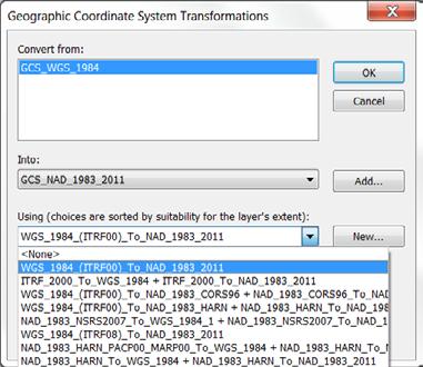
_To_NAD_1983_2011 (108363) NOT WGS_1984_(ITRF00)_To_NAD_1983_2011, or the ~25+ other NAD 83 WGS 84")
 NOT NAD 1983 (Conus), a zero transformation (used automatically with State Plane)")
26 This 7-parameter transformation is equivalent to the following commercial vendor transformations: ESRI: WGS_1984_(ITRF08)_To_NAD_1983_2011 (108363) NOT WGS_1984_(ITRF00)_To_NAD_1983_2011, or the ~25+ other NAD 83 WGS 84 transformations in ArcGIS 10.x Trimble: ITRF to NAD 1983 (2011) NOT NAD 1983 (Conus), a zero transformation (used automatically with State Plane) Topcon: NAD83 NOT NAD83_NO_TRANS, another zero transformation 7/15/ Esri User Conference 26
27 Does this stuff really matter? Significant for accuracies better than ~1-2 m Can be problem for combining accurate datasets Requires understanding of modern datums Be careful when using WGS 84 Which realization? At what epoch? At what level of accuracy? Things are moving, and it can make a difference e.g., San Diego moving 4.0 cm/yr NW w.r.t. Phoenix, AZ Modern GNSS becoming more precise Autonomous positions soon better than 1-2 m But accuracy another issue with respect to what? 7/15/ Esri User Conference 27
28 New Datums for the U.S. Planned release in 2022 Geometric datum: Aligned with ITRF/WGS 84 Vertical datum: Based on gravimetric geoid How much will NSRS coordinates change? North America plate (CONUS and AK): Approx 0.8 to 1.6 m Pacific plate: Approx 3.4 (Midway) to 4.3 m (American Samoa) Mariana plate: Approx 1.1 to 1.4 m How much will NSRS ellipsoid height change? Approx -1.9 m (Puerto Rico) to +2.0 m (Guam) How much will NSRS CONUS orthometric height change? Approx +0.1 m (Florida) to -1.3 m (Washington) 7/15/ Esri User Conference 28
29 NAD 83(2011) to IGS08 at epoch

30 NAD 83(PA11) to IGS08 at epoch

31 NAD 83(2011) to IGS08 at epoch
 surface minus NGS gravimetric")
32 Orthometric height change (meters) NAVD 88 to new vertical datum Estimated as NAVD 88 "zero" (datum) surface minus NGS gravimetric geoid
33 Conclusions Geodesy knowledge needed for correct georeferencing Becomes more important as spatial accuracy increases Driven by high precision and low cost of GNSS (a geodetic tool) High-accuracy geodetic transformations are complicated Time-dependence especially complex for differential tectonic motion Datasets representing different times difficult to spatially align Metadata (documentation) is essential Improves reliability and accuracy of data Increases value and usefulness of spatial data Needed all geospatial data (GIS, surveying, engineering, etc.) 7/15/ Esri User Conference 33

34 More information geodesy.noaa.gov 7/15/ Esri User Conference 34


35 An NGS Illustrated Guide to Geodesy for GIS Professionals Questions? 7/15/ Esri User Conference 35
Datum Transformations: Nightmare on GIS Street. Agenda
 Datum Transformations: Nightmare on GIS Street Speaker: Eric Gakstatter Contributing Editor GPS World Editor - Geospatial Solutions Presented at: Minnesota Society of Professional Surveyors Bloomington,
ELEMENTS OF THE NATIONAL SPATIAL REFERENCE SYSTEM
 Dave Doyle NGS Chief Geodetic Surveyor dave.doyle@noaa.gov 301-713-3178 ELEMENTS OF THE NATIONAL SPATIAL REFERENCE SYSTEM ESRI SURVEY SUMMIT San Diego, CA June 17, 2007 ftp://ftp.ngs.noaa.gov/dist/daved/esri
Lecture # 7 Coordinate systems and georeferencing
 Lecture # 7 Coordinate systems and georeferencing Coordinate Systems Coordinate reference on a plane Coordinate reference on a sphere Coordinate reference on a plane Coordinates are a convenient way of
Overview of New Datums NOAA s National Geodetic Survey
 Overview of New Datums NOAA s National Geodetic Survey February 3, 2015 1 NGS s Mission and Role NGS Mission: To define, maintain, and provide access to the National Spatial Reference System to meet our
Geodesy, Geographic Datums & Coordinate Systems
 Geodesy, Geographic Datums & Coordinate Systems What is the shape of the earth? Why is it relevant for GIS? 1/23/2018 2-1 From Conceptual to Pragmatic Dividing a sphere into a stack of pancakes (latitude)
Utilizing A GNSS Network Solution for Utility Applications
 Utilizing A GNSS Network Solution for Utility Applications David Newcomer, PE, PLS GPServ, Inc. newcomer@ (407) 601-5816 AGENDA Types and accuracies of data collection o Autonomous o Meter + o Sub-meter
Datums and Tools to Connect Geospatial Data Accurately
 Datums and Tools to Connect Geospatial Data Accurately Pamela Fromhertz Colorado State Geodetic Advisor National Geodetic Survey National Oceanic and Atmospheric Administration GIS-T April 18, 2012 Loveland,
High Precision GNSS for Mapping & GIS Professionals
 High Precision GNSS for Mapping & GIS Professionals Agenda Address your needs for GNSS knowledge. GNSS Basics Satellite Ranging Fundamentals (Code $ Carrier) Differential Corrections (Post Processed $
Determining Accurate Elevations: Datums & Tools, Today & Tomorrow
 Determining Accurate Elevations: Datums & Tools, Today & Tomorrow Association of State Floodplain Managers Annual Meeting Grand Rapids, MI Christine Gallagher June 21, 2016 Overview NGS Mission Important
Determining Accurate Elevations: Datums & Tools, Today & Tomorrow
 Determining Accurate Elevations: Datums & Tools, Today & Tomorrow Maryland Association Floodplain and Stormwater Managers Linthicum Heights, MD Christine Gallagher Oct. 20, 2016 Overview NGS Mission Important
Overview of New Datums
 Overview of New Datums Scott Lokken NC Advisor NOAA s National Geodetic Survey 9/4/2015 1 New Datums are Coming in 2022! Both a new geometric and a new geopotential (vertical) datum will be released in
NSRS Modernization Update
 geodesy.noaa.gov NSRS Modernization Update Scott Lokken National Geodetic Survey, NOAA Mid Atlantic Regional Geodetic Advisor Oct 05, 2017 Maryland Society of Surveyors Fall Conference NGS Regional Geodetic
Benefits and Impacts to Nautical Charting by Adopting a New Reference Frame. Dr. Neil Weston Office of Coast Survey, NOAA
 Benefits and Impacts to Nautical Charting by Adopting a New Reference Frame Dr. Neil Weston Office of Coast Survey, NOAA Motivation for this study NOAA s National Geodetic Survey New geometric reference
Datums for a Dynamic Earth
 Datums for a Dynamic Earth Based on a paper given at the American Society of Agricultural and Biological Engineers (ASABE) Conference in Reno, Nevada June 2009 Rollin StrohmanPh.D. Tom Mastin L.S Background
PREFACE. National Geographic Department would like to express our sincere thanks for your comments.
 PREFACE According to the role of National Geographic Department on Prim Minister s Decree No 255 PM, dated August 16, 2005 regarding to Surveying, Aerial Photography and mapping activities in the territory
CHAPTER 3. BASIC GEODESY
 CHAPTER 3. BASIC GEODESY SECTION I. THE GEODETIC SYSTEM A geodetic system serves as a framework for determining coordinates on the Earth s surface with respect to a reference ellipsoid and the geoid. It
Coordinates, Datums, and Map Projection
 Coordinates, Datums, and Map Projection Two views on the World Intersect at 90 o angles Latitude/ Longitude is a Spherical System Acceptable latitudes/longitudes i) W125 o 27 33 ii) N92 o 45 12 iii)
Introduction to Datums James R. Clynch February 2006
 Introduction to Datums James R. Clynch February 2006 I. What Are Datums in Geodesy and Mapping? A datum is the traditional answer to the practical problem of making an accurate map. If you do not have
WISCONSIN COORDINATE SYSTEMS
 Pdf versions of the Handout and Powerpoint slides are on jerrymahun.com. Follow the USPLSS Forum link and use the password: WildT2 WISCONSIN COORDINATE SYSTEMS CONCEPTS & IMPLEMENTATION Jerry Mahun, PLS,
Understanding the Evolution of WGS 84 and NAD 83
 Summary Both WGS 84, the datum used by GPS,, commonly used in North America, have been redefined several times since their beginning. Parallel to this, there have also been several realizations of the
Geodetic Positioning Refresher
 Geodetic Positioning Refresher by Joan Yau PhD ABCLS AGM 2016, Kimberley BC Contents Horizontal / Vertical Datums and Epochs used in BC and Canada How do we reference our project coordinates to BC datums
FieldGenius Technical Notes GPS Terminology
 FieldGenius Technical Notes GPS Terminology Almanac A set of Keplerian orbital parameters which allow the satellite positions to be predicted into the future. Ambiguity An integer value of the number of
CHAPTER 2 GEODESY AND DATUMS IN NAVIGATION
 CHAPTER 2 GEODESY AND DATUMS IN NAVIGATION GEODESY, THE BASIS OF CARTOGRAPHY 200. Definition Geodesy is the application of mathematics to model the size and shape of the physical earth, enabling us to
Basic Geodetics. Bobby Saleh Guidon Energy April 13, 2017
 Experts in Geomatics, Surveying, Positioning, Geospatial Data, and Mapping Sciences Basic Geodetics Bobby Saleh Guidon Energy b.saleh@guidonenergy.com April 13, 2017 The Earth is NOT flat Q: So what does
BILL HENNING, Prof LS. ACRONYMS
 BILL HENNING, Prof LS. ACRONYMS US 1 WIKIPEDIA: Also known as geodetics, geodetic engineering or geodetics engineering a branch of applied mathematics [2] and earth sciences, is the scientific discipline
GNSS & Coordinate Systems
 GNSS & Coordinate Systems Matthew McAdam, Marcelo Santos University of New Brunswick, Department of Geodesy and Geomatics Engineering, Fredericton, NB May 29, 2012 Santos, 2004 msantos@unb.ca 1 GNSS GNSS
Choosing the best path:
 GEODESY Choosing the best path: Global to national coordinate transformations The paper demonstrates that differences of up to a few centimetres in each coordinate component can occur depending on the
Standard for New Zealand Vertical Datum 2016 LINZS25009
 Standard for New Zealand Vertical Datum 2016 LINZS25009 Effective Date: 27 June 2016 Table of Contents TERMS ND DEFINITIONS... 3 FOREWORD... 5 INTRODUCTION... 5 PURPOSE OF STNDRD... 5 BRIEF HISTORY OF
GNSS 101 Bringing It Down To Earth
 GNSS 101 Bringing It Down To Earth Steve Richter Frontier Precision, Inc. UTM County Coordinates NGVD 29 State Plane Datums Scale Factors Projections Session Agenda GNSS History & Basic Theory Coordinate
BILL HENNING, Prof LS.
 BILL HENNING, Prof LS. DEFINITIONS: GEODESY, DATUMS, NSRS ACCESSING THE DATUM REALIZATION: PASSIVE MARKS, ACTIVE STATIONS WORLD SCIENTIFIC DATUMS HORIZONTAL, GEOMETRIC, VERTICAL, GRAVIMETRIC DATUMS IN
Using GPS to Establish the NAVD88 Elevation on Reilly The A-order HARN Station at NMSU
 Using GPS to Establish the NAVD88 Elevation on Reilly The A-order HARN Station at NMSU Earl F. Burkholder, PS, PE New Mexico State University Las Cruces, NM 88003 July 005 Introduction GPS has become an
Standard for the Australian Survey Control Network
 Standard for the Australian Survey Control Network Special Publication 1 Intergovernmental Committee on Survey and Mapping (ICSM) Geodesy Technical Sub-Committee (GTSC) 30 March 2012 Table of contents
Lecture 14 NAD 83(NSRS), NAD 83(CORS 96), WGS84 and ITRF
, NAD 83(CORS 96), WGS84 and ITRF") Lecture 14 NAD 83(NSRS), NAD 83(CORS 96), WGS84 and ITRF Monday, March 1, 2010 2 March 2010 GISC3325 NAD 27 and NAD 83 NAD 27 and NAD 83 Versions of NAD 83 First implementation labeled NAD 83 (1986). Deficiencies
Lecture 14 NAD 83(NSRS), NAD 83(CORS 96), WGS84 and ITRF Monday, March 1, 2010 2 March 2010 GISC3325 NAD 27 and NAD 83 NAD 27 and NAD 83 Versions of NAD 83 First implementation labeled NAD 83 (1986). Deficiencies
Lecture 16 NAD 83 (1986), NAD 83(1993) and NAD 83 (NSRS 2007) 10 March 2009 GISC3325
, NAD 83(1993) and NAD 83 (NSRS 2007) 10 March 2009 GISC3325") Lecture 16 NAD 83 (1986), NAD 83(1993) and NAD 83 (NSRS 2007) 10 March 2009 GISC3325 Significant dates 16-20 March 2009 is Spring Break 12 March 2009 is Exam Two Emphasis on chapter 5, 6 and 8 of text
Lecture 16 NAD 83 (1986), NAD 83(1993) and NAD 83 (NSRS 2007) 10 March 2009 GISC3325 Significant dates 16-20 March 2009 is Spring Break 12 March 2009 is Exam Two Emphasis on chapter 5, 6 and 8 of text
GPS Technical Aspects
 GPS Technical Aspects Charles Ghilani (cghilani@psu.edu) Turn off all cell phones Or set them to vibrate Class Etiquette Ask questions at any point during the class. Simply speak up so that all can hear
GPS Pathfinder Office Software or the GPS Analyst Extension for ESRI ArcGIS Software: Resolving the NAD 83 Datum Transformation Issue
 Mapping & GIS Support Note 5 May 2005 GPS Pathfinder Office Software or the GPS Analyst Extension for ESRI ArcGIS Software: Resolving the NAD 83 Datum Transformation Issue Summary The current realizations
GPS Pathfinder Office Software or GPS Analyst Extension for ESRI ArcGIS Software: Resolving the NAD 83 Datum Transformation Issue
 13 June 2011 GPS Pathfinder Office Software or GPS Analyst Extension for ESRI ArcGIS Software: Resolving the NAD 83 Datum Transformation Issue Summary The current realizations of the North American Datum
Modernization of the National Spatial Reference System Keeping Pace with Changes in Positioning Technology and User Expectations in a Dynamic World
 Modernization of the National Spatial Reference System Keeping Pace with Changes in Positioning Technology and User Expectations in a Dynamic World Wisconsin Society of Land Surveyors Institute Wisconsin
A NEW GEOCENTRIC DATUM FOR NEW ZEALAND
 A NEW GEOCENTRIC DATUM FOR NEW ZEALAND Don Grant Graeme Blick Office of Surveyor-General Land Information New Zealand PO Box 5501 Wellington New Zealand Phone 04 4600100 Fax 04 4722244 dgrant@linz.govt.nz
LAB PROCEDURES: TOPCON TOOLS FAMILIARIZATION
 LAB PROCEDURES: TOPCON TOOLS FAMILIARIZATION This lab will cover the basic setup and processing options of Topcon Tools (TT). We will learn how to start a project, upload data and control files, set up
CHAPTER 2 GEODESY AND DATUMS IN NAVIGATION
 CHAPTER 2 GEODESY AND DATUMS IN NAVIGATION GEODESY, THE BASIS OF CARTOGRAPHY 200. Definition Geodesy is the science concerned with the exact positioning of points on the surface of the earth. It also involves
Appendix A Lower Columbia River Chart Datum Modeling
 Appendix A Lower Columbia River Chart Datum Modeling David Evans and Associates, Inc. David Evans and Associates, Inc. 2801 SE Columbia Way, Ste. 130 Vancouver, WA 98661 (360) 314-3200 1.0 Vertical Datum
The Global Positioning System II Field Experiments. 10/10/2013 GEO327G/386G, UT Austin 5-1
 The Global Positioning System II Field Experiments 10/10/2013 GEO327G/386G, UT Austin 5-1 Mexico DGPS Field Campaign Cenotes in Tamaulipas, MX, near Aldama 10/10/2013 GEO327G/386G, UT Austin 5-2 Are Cenote
Salient Feature of ITRF. Realization of Dubai Emirate Datum. Reference Frame 2000 (Ditr 2000)
") Salient Feature of ITRF on the Reference Frame 2000 (Ditr 2000) ITRF stands for International Terrestrial Reference Frame ITRF established by the International Earth Rotation Service (IERS), France. One
Salient Feature of ITRF on the Reference Frame 2000 (Ditr 2000) ITRF stands for International Terrestrial Reference Frame ITRF established by the International Earth Rotation Service (IERS), France. One
DYNAMIC RT TECHNOLOGY
 DYNAMIC RT TECHNOLOGY GLOBAL NAVIGATION SATELLITE SYSTEMS (GNSS) POTENTIAL FUTURE DEVELOPMENTS(2005 2017?) GPS MODERNIZATION BLOCK IIF & III GLONASS ENHANCEMENTS (K & M) EUROPEAN UNION - GALILEO CHINA
What makes the positioning infrastructure work. Simon Kwok Chairman, Land Surveying Division Hong Kong Institute of Surveyors
 What makes the positioning infrastructure work The experience of the Hong Kong Satellite Positioning Reference Station Network Simon Kwok Chairman, Land Surveying Division Hong Kong Institute of Surveyors
The Global Positioning System II Field Experiments
 The Global Positioning System II Field Experiments 5-1 Mexico DGPS Field Campaign Cenotes in Tamaulipas, MX, near Aldama 5-2 Are Cenote Water Levels Related? 5-3 DGPS Static Survey of Cenote Water Levels
21st International Conference of The Coastal Society
 21st International Conference of The Coastal Society DEVELOPMENT OF A VERTICAL DATUM TRANSFORMATION TOOL AND A BATHYMETRIC/TOPOGRAPHIC DIGITAL ELEVATION MODEL FOR SOUTHERN CALIFORNIA Edward P. Myers, NOAA/NOS
The Global Positioning Sytem II 10/19/2017
 The Global Positioning System II Field Experiments 10/19/2017 5-1 Mexico DGPS Field Campaign Cenotes in Tamaulipas, MX, near Aldama 10/19/2017 5-2 Are Cenote Water Levels Related? 10/19/2017 5-3 M. Helper,
DATUM TRANSFORMATION BETWEEN NATIONAL GEODETIC DATUM AND ITRF
 DATUM TRANSFORMATION BETWEEN NATIONAL GEODETIC DATUM AND ITRF M.Sc. Zlatko Bogdanovsk i FCE Skopje Chair for High Geodesy INTRODUCTION COORDINATE TRANSFORMATION Need of establishing dependence between
Application of GPS/GNSS in Cybermapping. Cybermapping Lab University of Texas at Dallas 2009
 Application of GPS/GNSS in Cybermapping Cybermapping Lab University of Texas at Dallas 2009 GNSS Global Navigation Satellite System (GNSS) is the standard generic term for satellite navigation systems
Progress Towards the Seamless Combination of Bathymetric and Topographic Data in New Zealand
 Progress Towards the Seamless Combination of Bathymetric and Topographic Data in New Zealand Matt Amos Senior Technical Advisor National Geodetic Office Introduction Datasets usually defined in terms of
Chapter 6 GPS Relative Positioning Determination Concepts
 Chapter 6 GPS Relative Positioning Determination Concepts 6-1. General Absolute positioning, as discussed earlier, will not provide the accuracies needed for most USACE control projects due to existing
AUSPOS GPS Processing Report
 AUSPOS GPS Processing Report February 13, 2012 This document is a report of the GPS data processing undertaken by the AUSPOS Online GPS Processing Service (version: AUSPOS 2.02). The AUSPOS Online GPS
National Height Modernization: Cost comparison of conducting a vertical survey by leveling versus by GPS in western North Carolina
 Introduction: National Height Modernization: Cost comparison of conducting a vertical survey by leveling versus by GPS in western North Carolina The North Carolina Geodetic Survey (NCGS) conducted a National
GPS STATIC-PPP POSITIONING ACCURACY VARIATION WITH OBSERVATION RECORDING INTERVAL FOR HYDROGRAPHIC APPLICATIONS (ASWAN, EGYPT)
") GPS STATIC-PPP POSITIONING ACCURACY VARIATION WITH OBSERVATION RECORDING INTERVAL FOR HYDROGRAPHIC APPLICATIONS (ASWAN, EGYPT) Ashraf Farah Associate Professor,College of Engineering, Aswan University,
GPS STATIC-PPP POSITIONING ACCURACY VARIATION WITH OBSERVATION RECORDING INTERVAL FOR HYDROGRAPHIC APPLICATIONS (ASWAN, EGYPT) Ashraf Farah Associate Professor,College of Engineering, Aswan University,
Definition and use of the New Zealand Vertical Datum Matt Amos Senior Advisor Geodesy
 Definition and use of the New Zealand Vertical Datum 2009 Matt Amos Senior Advisor Geodesy NZIS Continuing Professional Development Programme, November 2009 Overview Height Theory Heights in New Zealand
The coordinate system and vertical datum shall be noted in the drawing in the metadata.
 Purpose This document is provided for informational purposes and to assure data compatibility and compliance for as-built drawings or vector data formats specifically for the 354th Civil Engineer Squadron
CHAPTER 5 Vertical Control. CE 316 January 2012
 CHAPTER 5 Vertical Control CE 316 January 01 137 5.1 Introduction Vertical Datums Leveling Techniques and Corrections Bench Mark Design and Construction Bench Mark Data Trigonometric Barometric Leveling
Who s heard of the GDA2020?
 Implications of a next generation datum in Australia on mining operations: A discussion. School of Civil & Environmental Engineering Craig Roberts Senior lecturer Surveying and Geospatial Engineering group
The realization of a 3D Reference System
 The realization of a 3D Reference System Standard techniques: topographic surveying and GNSS Observe angles and distances either between points on the Earth surface or to satellites and stars. Do not observe
Errors in GPS. Errors in GPS. Geodetic Co-ordinate system. R. Khosla Fall Semester
 Errors in GPS Errors in GPS GPS is currently the most accurate positioning system available globally. Although we are talking about extreme precision and measuring distances by speed of light, yet there
Connecting a Cadastral Survey to PNG94 using GNSS
 43rd Association of Surveyors PNG Congress, Lae, 12th-15th August 2009 Connecting a Cadastral Survey to PNG94 using GNSS Richard Stanaway QUICKCLOSE Workshop overview Legal requirements to connect surveys
PROPOSED NATIONAL GEODETIC DATABASE (NGDB) Coordinates. Orthometric Height Source
 Coordinates. Orthometric Height Source") Stations Name1, Name2, Name3 Custodian Orthometric Height Height Identifier MSL/AHD height Vert Class, Vert order, Ht method Supersedes, superseded by (double linked list AHD/MSL datum COMMENTS Fieldbooks
Stations Name1, Name2, Name3 Custodian Orthometric Height Height Identifier MSL/AHD height Vert Class, Vert order, Ht method Supersedes, superseded by (double linked list AHD/MSL datum COMMENTS Fieldbooks
Geodetic Reference Frame Theory
 Technical Seminar Reference Frame in Practice, Geodetic Reference Frame Theory and the practical benefits of data sharing Geoffrey Blewitt University of Nevada, Reno, USA http://geodesy.unr.edu Sponsors:
GPS Geodetic Reference System WGS 84
 GPS Geodetic Reference System WGS 84 International Committee on GNSS Working Group D Saint Petersburg, Russia 16 September 2009 Barbara Wiley National Geospatial-Intelligence Agency United States of America
GNSS: orbits, signals, and methods
 Part I GNSS: orbits, signals, and methods 1 GNSS ground and space segments Global Navigation Satellite Systems (GNSS) at the time of writing comprise four systems, two of which are fully operational and
OPTIMUM GEODETIC DATUM TRANSFORMATION TECHNIQUES FOR GPS SURVEYS IN EGYPT
 Proceedings of Al-Azhar Engineering Sixth International Conference, Sept. 1-, 2000, Cairo, Egypt, Volume, pp. 09-1. OPTIMUM GEODETIC DATUM TRANSFORMATION TECHNIQUES FOR GPS SURVEYS IN EGYPT By Dr. Gomaa
Global Positioning Systems - GPS
 Global Positioning Systems - GPS GPS Why? What is it? How does it work? Differential GPS How can it help me? GPS Why?? Where am I? How do I get there? Where are you, and how do I get to You? WHO CARES???
GPS for crustal deformation studies. May 7, 2009
 GPS for crustal deformation studies May 7, 2009 High precision GPS for Geodesy Use precise orbit products (e.g., IGS or JPL) Use specialized modeling software GAMIT/GLOBK GIPSY OASIS BERNESE These software
Using RTK GNSS Wisely
 Using RTK GNSS Wisely February 017 Autonomous Positioning Differential Positioning Concept: Detect and cancel identical errors with simultaneous observation. F + E = G + E 1 Static & RTK Computations Static
Math 215 Project 1 (25 pts) : Using Linear Algebra to solve GPS problem
 : Using Linear Algebra to solve GPS problem") Due 11:55pm Fri. Sept. 28 NAME(S): Math 215 Project 1 (25 pts) : Using Linear Algebra to solve GPS problem 1 Introduction The age old question, Where in the world am I? can easily be solved nowadays by
Due 11:55pm Fri. Sept. 28 NAME(S): Math 215 Project 1 (25 pts) : Using Linear Algebra to solve GPS problem 1 Introduction The age old question, Where in the world am I? can easily be solved nowadays by
New Zealand Reference Frame Case Study
 New Zealand Reference Frame Case Study Graeme Blick Chief Geodesist Land Information New Zealand 1 Fundamental role of the reference frame Requirements of a National Reference System A coordinate framework
Global Positioning Systems -GPS
 Global Positioning Systems -GPS GPS Why? What is it? How does it work? Differential GPS How can it help me? GPS Why?? Where am I? How do I get there? Where are you, and how do I get to You? WHO CARES???
Philippine Geodetic Infrastructure Status, Challenges and Future Direction
 Philippine Geodetic Infrastructure Status, Challenges and Future Direction Engr. Charisma Victoria D. Cayapan National Mapping and Resource Information Authority PHILIPPINES Outline Evolution of Geodetic
CGG. Office of the Surveyor General of the Federation Federal Capital Territory, Abuja, Nigeria 2
 Prof. P. C. Nwilo 1, * Dr. J. D. Dodo 2, U. R. Edozie 1, and A. Adebomehin 1. 1 Office of the Surveyor General of the Federation Federal Capital Territory, Abuja, Nigeria 2 Centre for Geodesy and Geodynamics,
Instruction with Hands-on Practice: Creating a Bathymetric Database & Datum Conversion
 Instruction with Hands-on Practice: Creating a Bathymetric Database & Datum Conversion Tanya Beck Coastal and Hydraulics Laboratory Engineer Research and Development Center May 17, 2010 US Army Corps of
Connecting a Survey to PNG94 and MSL using GNSS
 45th Association of Surveyors PNG Congress, Madang, 19-22 July 2011 Connecting a Survey to PNG94 and MSL using GNSS Richard Stanaway QUICKCLOSE Workshop overview Legal requirements to connect surveys to
Map Basics: Datums and Coordinate Systems
 Map Basics: Datums and Coordinate Systems ESRM 304 Autumn 2015 Contributors: Phil Hurvitz, Peter Schiess, Eric Turnblom 1 of 39 Datums, land division systems, & coordinate systems Datums (from Wikipedia)
BUILDING A SINGLE VERSION OF TRUTH
 BUILDING A SINGLE VERSION OF TRUTH Versioning in PPDM Tarun Chandrasekhar Director, Data Management Products Neuralog AGENDA Introductions Importance of Source Need for multiple sources Source Prioritization
t =1 Transmitter #2 Figure 1-1 One Way Ranging Schematic
 1.0 Introduction OpenSource GPS is open source software that runs a GPS receiver based on the Zarlink GP2015 / GP2021 front end and digital processing chipset. It is a fully functional GPS receiver which
GEODESY LESSON PLAN Meet Geodesy
 Meet Lesson Plan GEODESY LESSON PLAN Meet Focus Introduction to geodesy Grade Level 9-12 Focus Question What is geodesy, and why is it important? Learning Objectives Students will be able to define geodesy.
GPS for. Land Surveyors. Jan Van Sickle. Fourth Edition. CRC Press. Taylor & Francis Group. Taylor & Francis Croup, an Informa business
 GPS for Land Surveyors Fourth Edition Jan Van Sickle CRC Press Taylor & Francis Group Boca Raton London New York CRC Press is an imprint of the Taylor & Francis Croup, an Informa business Contents Preface
NJDEP GPS Data Collection Standards for GIS Data Development
 NJDEP GPS Data Collection Standards for GIS Data Development Bureau of Geographic Information Systems Office of Information Resource Management April 24 th, 2017 Table of Contents 1.0 Introduction... 3
VERTICAL DATUM TRANSFORMATIONS FOR KINEMATIC GPS HYDROGRAPHIC SURVEYS. Kurt W. Hess, Dennis G. Milbert, Stephen K. Gill, and Daniel R.
 VERTICAL DATUM TRANSFORMATIONS FOR KINEMATIC GPS HYDROGRAPHIC SURVEYS Kurt W. Hess, Dennis G. Milbert, Stephen K. Gill, and Daniel R. Roman National Ocean Service, NOAA ABSTRACT Kinematic Global Positioning
U.S. Army Corps of Engineers: Review of Progress Toward Consistent Vertical Datums. by Jim Garster and Mark Huber
 U.S. Army Corps of Engineers: Review of Progress Toward Consistent Vertical Datums by Jim Garster and Mark Huber i ii Abstract A vertical datum is the most important part of any geospatial data, no matter
SOME OBSERVATIONS ON THE USE OF GPS AND CHARTS
 International Hydrographic Review, Monaco, LXX(2), September 1993 SOME OBSERVATIONS ON THE USE OF GPS AND CHARTS by D. SIMPSON 1 INTRODUCTION The purpose of this paper is to bring to the attention of chart
Guidelines for Laying Targets for Ground Control Points
 Guidelines for Laying Targets for Ground Control Points Overview of target requirements: Three to four unambiguous ground survey targets, recognizable in the satellite photo, are requested. The survey
Application of GPS heights to Bay of Fundy multibeam data
 GEOLOGICAL SURVEY OF CANADA OPEN FILE 6658 Application of GPS heights to Bay of Fundy multibeam data David W. Dodd 2010 GEOLOGICAL SURVEY OF CANADA OPEN FILE 6658 Application of GPS heights to Bay of Fundy
9/26/2016. Accuracy with GNSS What are you getting? Presented By Tom Bryant PLS Kelly Harris PLS Seiler Instrument
 Accuracy with GNSS What are you getting? Presented By Tom Bryant PLS Kelly Harris PLS Seiler Instrument 1 What We Will Talk About Today What coordinate system should I use in my data collector Site Calibrations-what
IAG School on Reference Systems June 7 June 12, 2010 Aegean University, Department of Geography Mytilene, Lesvos Island, Greece SCHOOL PROGRAM
 IAG School on Reference Systems June 7 June 12, 2010 Aegean University, Department of Geography Mytilene, Lesvos Island, Greece SCHOOL PROGRAM Monday June 7 8:00-9:00 Registration 9:00-10:00 Opening Session
GNSS Technology Update
 GNSS Technology Update Speaker: Eric Gakstatter Contributing Editor GPS World Editor - Geospatial Solutions Presented at: Association of Petroleum Surveying & Geomatics Houston, TX April 7, 2015 Agenda
Development of Geoid Based Vertical Datums, A New Zealand Perspective
 Technical Seminar Reference Frame in Practice, Development of Geoid Based Vertical Datums, A New Zealand Perspective Matt Amos Manager Positioning and Innovation Land Information New Zealand Sponsors:
GROUND CONTROL SURVEY REPORT
 GROUND CONTROL SURVEY REPORT Services provided by: 3001, INC. a Northrop Grumman company 10300 Eaton Place Suite 340 Fairfax, VA 22030 Ground Control Survey in Support of Topographic LIDAR, RGB Imagery
TDS Ranger Survey Pro CE Version RTK Base on known Control Point. RTK Rover - Localization with Control Points.
 TDS Ranger Survey Pro CE Version 2.1.8 RTK Base on known Control Point. RTK Rover - Localization with Control Points. Pre-load control Coordinates and appropriate NGS Geoid 99/96 data files into the Ranger
GIS Tips and Tricks. Jennifer Harrison President, Inner Corridor Technologies, Inc. ESRI Certified Training Partner (CTP) Let s talk about chocolate
 Let s talk about chocolate") GIS Tips and Tricks Jennifer Harrison President, Inner Corridor Technologies, Inc. ESRI Certified Training Partner (CTP) 1-1 Let s talk about chocolate 1-2 Revised 04/11 1 Tips and Tricks for working with
GIS Tips and Tricks Jennifer Harrison President, Inner Corridor Technologies, Inc. ESRI Certified Training Partner (CTP) 1-1 Let s talk about chocolate 1-2 Revised 04/11 1 Tips and Tricks for working with
Part VII: Control Surveying
 Part VII: Control Surveying Control Surveying consists of research, measurements, calculations and reports detailing the horizontal and vertical reference systems established for the survey. 7.1. Sources
PageNET: In Support of the Surveying Community
 Philippine Active Geodetic Network : In Support of the Surveying Community ICG Experts Meeting: Global Navigation Satellite Systems Services Vienna International Center, Vienna, Austria December 14-18,
GLOBAL POSITIONING SYSTEMS
 GLOBAL POSITIONING SYSTEMS GPS & GIS Fall 2017 Global Positioning Systems GPS is a general term for the navigation system consisting of 24-32 satellites orbiting the Earth, broadcasting data that allows
MONITORING SEA LEVEL USING GPS
 38 MONITORING SEA LEVEL USING GPS Hasanuddin Z. Abidin* Abstract GPS (Global Positioning System) is a passive, all-weather satellite-based navigation and positioning system, which is designed to provide