ELEMENTS OF THE NATIONAL SPATIAL REFERENCE SYSTEM
|
|
|
- Kory Annabel Simon
- 5 years ago
- Views:
Transcription

1 Dave Doyle NGS Chief Geodetic Surveyor ELEMENTS OF THE NATIONAL SPATIAL REFERENCE SYSTEM ESRI SURVEY SUMMIT San Diego, CA June 17, 2007 ftp://ftp.ngs.noaa.gov/dist/daved/esri


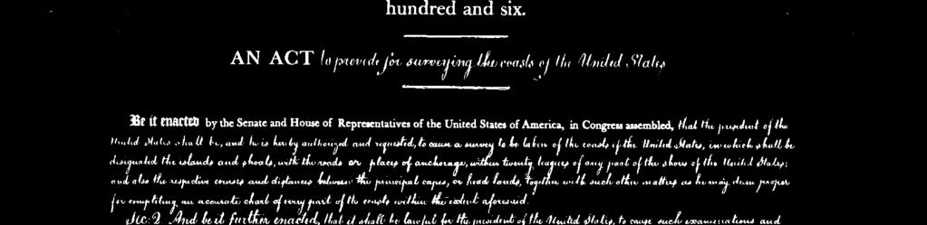


2 1807 President Thomas Jefferson signs legislation establishing the Survey of the Coast


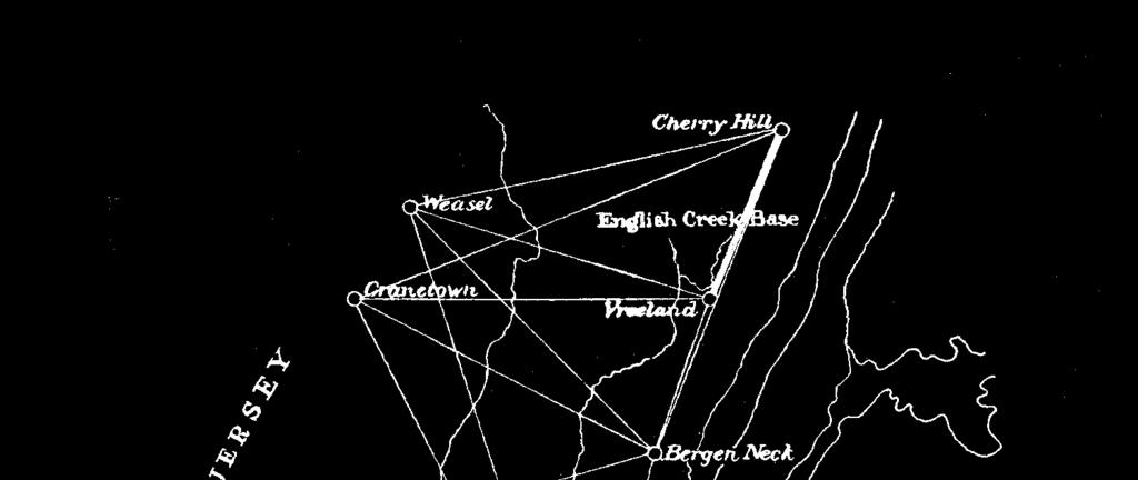
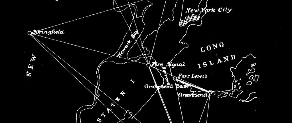
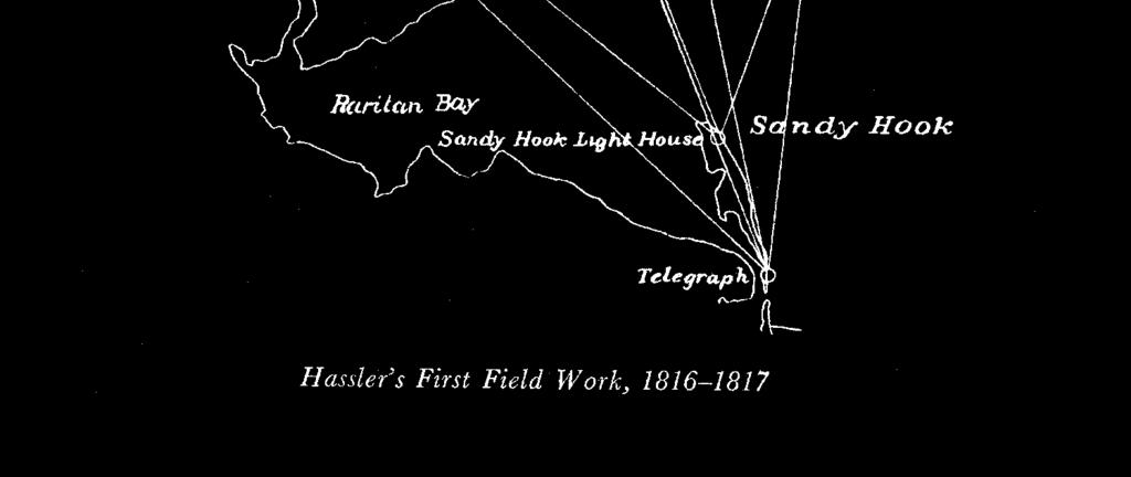
3 Ferdinand Hassler ( )
4 Our Positioning History What s In a Name? Survey of the Coast Coast Survey US Coast and Geodetic Survey National Ocean Service National Geodetic Survey (NOS geodetic functions)


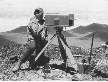
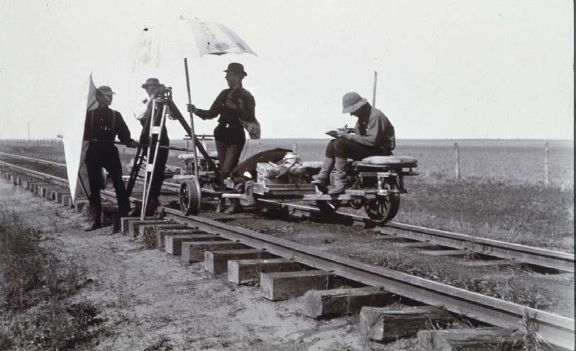
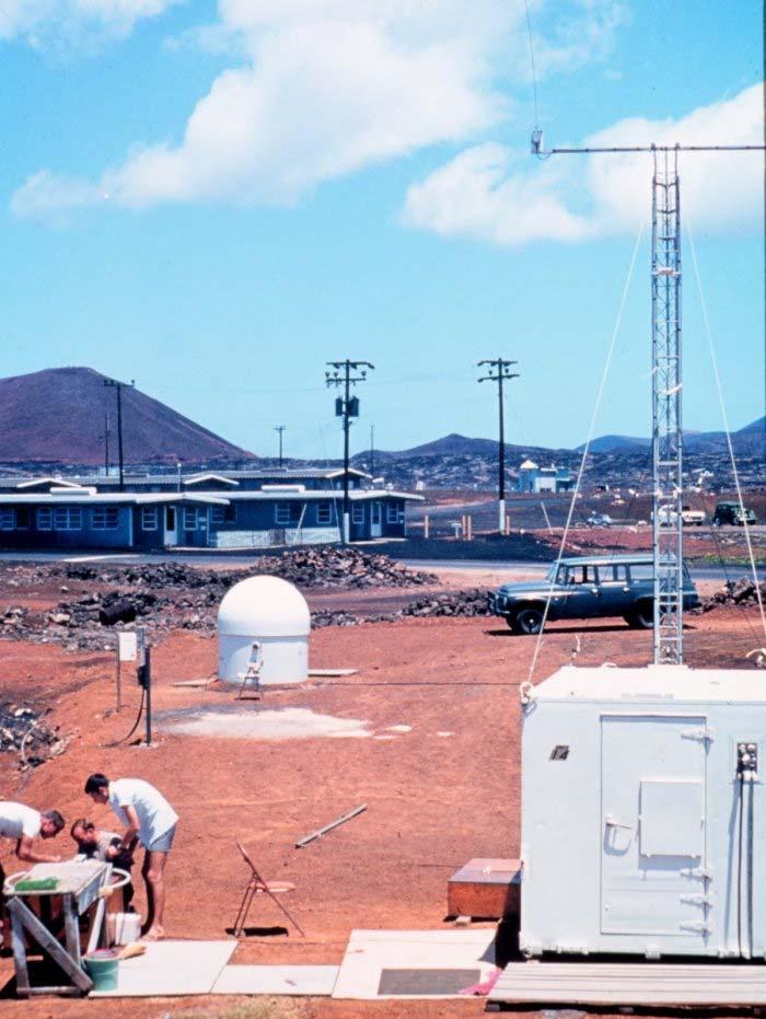
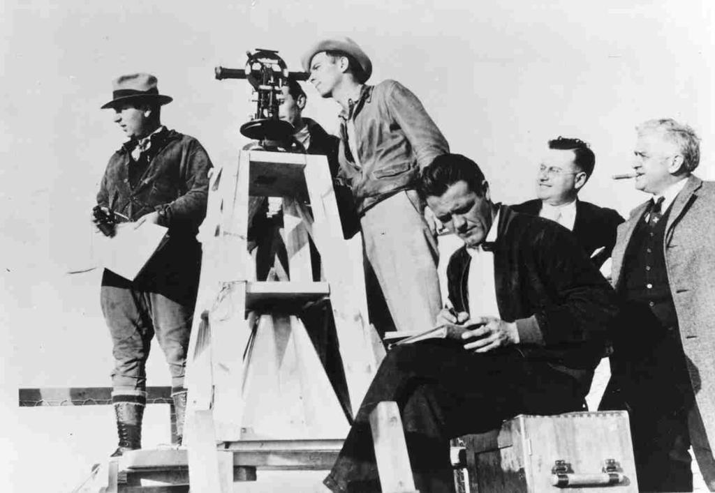
5 Bilby Tower used from

6

7

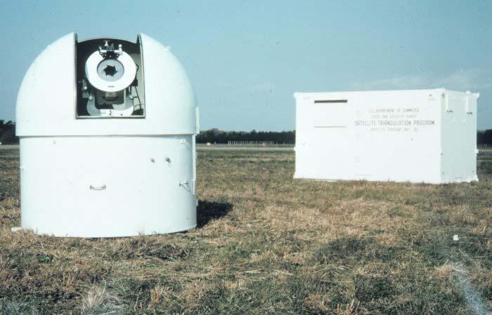
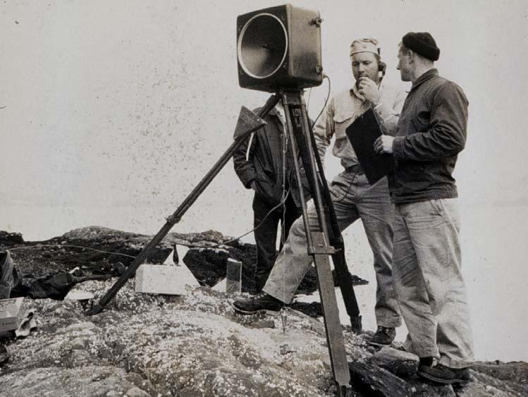
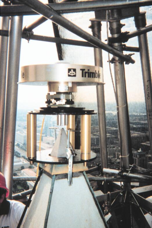
8 Global Satellite Triangulation Network

9 Positioning the Washington Monument
10


11
12 GEODETIC CONTROL THE REALIZATION OF A DATUM NETWORK OF MONUMENTED POINTS PRECISELY MEASURED IN ACCORDANCE WITH STANDARD PROCEDURES MEET ACCURACY SPECIFICATIONS ADJUSTED TO TIE TOGETHER DOCUMENTED FOR MULTIPLE USE

13 National Spatial Reference System (NSRS) Consistent National Coordinate System Latitude Longitude Height Scale Gravity Orientation and how these values change with time

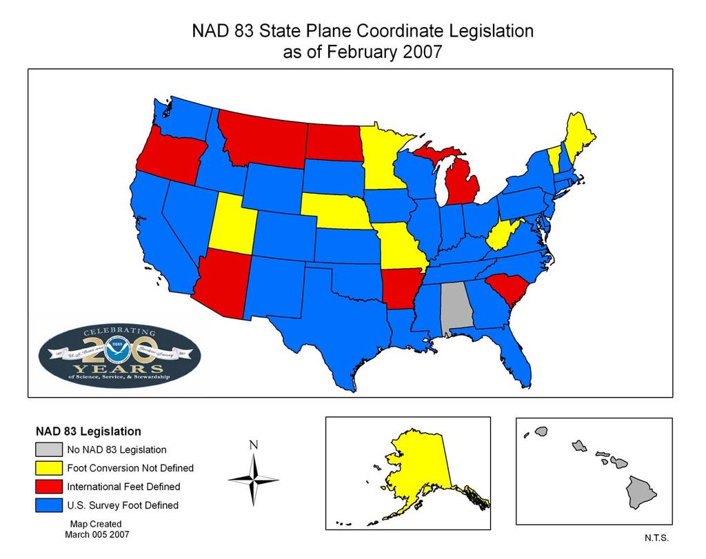
14 National Spatial Reference System (NSRS) U.S.HORIZONTAL DATUMS BESSEL COORDINATES ( ) NEW ENGLAND DATUM ( ) U.S. STANDARD DATUM ( ) ALASKA DATUMS (14 Different ) PUERTO RICO DATUM ( ) NORTH AMERICAN DATUM ( ) NORTH AMERICAN DATUM 1927 ( ) OLD HAWAIIAN DATUM ( ) NORTH AMERICAN DATUM 1983 (1983 PRESENT)

 THIRD GENERAL")
 SEA LEVEL DATUM 1929 NATIONAL")


15 National Spatial Reference System (NSRS) U.S.VERTICAL DATUMS FIRST GENERAL ADJUSTMENT/SANDY HOOK DATUM (1899) SECOND GENERAL ADJUSTMENT (1903) THIRD GENERAL ADJUSTMENT (1907) FOURTH GENERAL ADJUSTMENT (1914) SEA LEVEL DATUM 1929 NATIONAL GEODETIC VERTICAL DATUM 1929 NORTH AMERICAN VERTICAL DATUM 1988 AMERICAN SAMOA VERTICAL DATUM 2002 PUERTO RICO VERTICAL DATUM 2002 NORTHERN MARIANAS VERTICAL DATUM 2003 GUAM VERTICAL DATUM 2004


16 NSRS COMPONENTS National Shoreline Consistent, accurate, and up-to-date Networks of geodetic control points Permanently marked passive survey monuments National and Cooperative CORS A network of GPS Continuously Operating Reference Stations Models and Tools Models of geophysical effects on spatial measurements e.g., NADCON, INVERSE, SPCS83, UTMS, FORWARD Standards & Guidelines Facilitate the development, sharing, and use of geospatial data
17 NATIONAL SPATIAL REFERENCE SYSTEM ACCURATE -- cm accuracy on a global scale MULTIPURPOSE -- Supports Geodesy, Geophysics, Land Surveying, Navigation, Mapping, Charting and GIS activities ACTIVE -- Accessible through Continuously Operating Reference Stations (CORS) and derived products INTEGRATED -- Related to International services and standards (e.g. International Earth Rotation and Reference Systems Service, International GNSS Service etc.)
18 NATIONAL SPATIAL REFERENCE SYSTEM North American Datum of 1983 (NAD 83) North American Vertical Datum of 1988 (NAVD 88) First civilian datums designed to be consistent with space-based observations (GPS) First civilian datums to be best-fitting globally not locally First geodetic reference systems to be fully automated First geodetic reference systems to be available free from WWW Only reference system to freely integrate data from outside sources

19 NSRS Coordinate Systems Latitude & Longitude State Plane Coordinates UTM Coordinates U.S. National Grid Earth-Centered Earth-Fixed NAD 83 NAD 27 NAVD 88 NGVD 29 ITRF00
20
21 UNITED STATES ELLIPSOID DEFINITIONS N GEODETIC REFERENCE SYSTEM (GRS 80) (1986 Present) CLARKE b a = 6,378,137 BESSEL m 1/f = International standard (1879 (1851 adopted 1986) 1879) by IAG/IUGG/NGS a = 6,377, ,378,206.4 m m 1/f = Best Best fit East fit North Coast America of U.S. a WORLD GEODETIC SYSTEM (WGS 84) (1987 Present) a = 6,378,137 m 1/f = Defined for GPS by U.S. DoD a = Semi major axis b = Semi minor axis f = a-b = Flattening a S
22 ELLIPSOID - GEOID RELATIONSHIP H = Orthometric Height (NAVD 88) h = Ellipsoidal Height (NAD 83 NSRS 2007) N = Geoid Height (GEOID 03) H = h N H h Geoid N GEOID03 Ellipsoid GRS80
23 GEOID90 Various NGS Geoid models Earliest model gravimetric only GEOID93 Another early gravimetric geoid GEOID96 GEOID99 GEOID03 First hybrid geoid CONUS only Underlain by G96SSS gravimetric model Accuracy ~ 11.6 cm (95%) Still fairly heavily used - CONUS Underlain by G99SSS gravimetric model Accuracy ~ 9.2 cm (95%) Models tie to NAD 83 everywhere hybrid in CONUS Underlain by the USGG2003 gravimetric model Accuracy ~ 4.8 cm (95%) GEOID06 Forthcoming this year. Available for Alaska already. Will tie to NAD 83 and NAVD 88/PRVD02/etc. Accuracy ~ 2 cm (?)
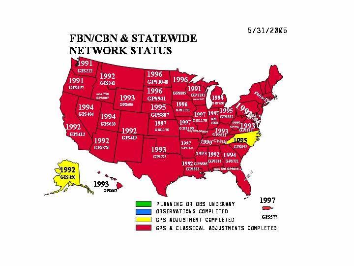
24 EARLY NAD 83 NETWORK PROBLEMS NOT GPSABLE POOR STATION ACCESSIBILITY IRREGULARLY SPACED POSITIONAL ACCURACY
25 HIGH ACCURACY REFERENCE NETWORKS (HARN) GPSABLE Clear Horizons for Satellite Signal Acquisition EASY ACCESSIBILITY Few Special Vehicle or Property Entrance Requirements REGULARLY SPACED Always within Km HIGH ACCURACY A-Order (5 mm + 1:10,000,000) (3 5.5 hr sessions) B-Order (8mm + 1:1,000,000) (2 5.5 hr sessions)
26 FEDERAL AND COOPERATIVE BASE NETWORKS (FBN/CBN) MORE STATE PARTNERSHIPS REMOVE DISTORTIONS IN EARLY HARNS (3-10 CM) ENSURE CONNETIONS TO CORS IMPROVE ELLIPSOID HEIGHT ACCURACY (Not worse than 2 cm)
27
28 CONTINUOUSLY OPERATING REFERENCE STATIONS (CORS) Installed and Operated by various Federal-State-local Agencies NOAA/National Geodetic Survey NOAA/OAR Global Systems Division U.S. Coast Guard - DGPS/NDGPS Corps of Engineers - DGPS FAA - WAAS/LAAS State DOTs County and City Academia Private Companies

29 CONTINUOUSLY OPERATING REFERENCE STATIONS (CORS) Dual-Frequency Antennas and Receivers Allen-Osborne Ashtech / Thales Leica Topcon Trimble
30 CONTINUOUSLY OPERATING REFERENCE STATIONS (CORS) NGS PROVIDES Reference Site Survey Monumentation Horizontal and Vertical NSRS Connections NAD 83 and ITRF00 Coordinates Network Data Collection - Hourly & Daily Daily 3D Network Integrity Adjustment Public Data Distribution - Internet 13 Year On-Line Data Holding
31 The National Geodetic Survey Ten Year Plan: Mission, Vision and Strategy
32 Ten-Year Milestones (2017) 1) NGS will compute a pole-to-equator, Alaskato-Newfoundland geoid model, preferably in conjunction with Mexico and Canada as well as other interested governments, with an accuracy of 1 cm in as many locations as possible 2) NGS redefines the vertical datum based on GNSS and a gravimetric geoid 3) NGS redefines the national horizontal datum to remove disagreements with the ITRF
33 GOOD COORDINATION BEGINS WITH GOOD COORDINATES GEOGRAPHY WITHOUT GEODESY IS A FELONY
An NGS Illustrated Guide to Geodesy for GIS Professionals
 An NGS Illustrated Guide to Geodesy for GIS Professionals Michael Dennis, RLS, PE michael.dennis@noaa.gov Esri User Conference San Diego Convention Center July 14-18, 2014 San Diego, CA Why should we care
Overview of New Datums
 Overview of New Datums Scott Lokken NC Advisor NOAA s National Geodetic Survey 9/4/2015 1 New Datums are Coming in 2022! Both a new geometric and a new geopotential (vertical) datum will be released in
Overview of New Datums NOAA s National Geodetic Survey
 Overview of New Datums NOAA s National Geodetic Survey February 3, 2015 1 NGS s Mission and Role NGS Mission: To define, maintain, and provide access to the National Spatial Reference System to meet our
Datums and Tools to Connect Geospatial Data Accurately
 Datums and Tools to Connect Geospatial Data Accurately Pamela Fromhertz Colorado State Geodetic Advisor National Geodetic Survey National Oceanic and Atmospheric Administration GIS-T April 18, 2012 Loveland,
Determining Accurate Elevations: Datums & Tools, Today & Tomorrow
 Determining Accurate Elevations: Datums & Tools, Today & Tomorrow Association of State Floodplain Managers Annual Meeting Grand Rapids, MI Christine Gallagher June 21, 2016 Overview NGS Mission Important
Geodesy, Geographic Datums & Coordinate Systems
 Geodesy, Geographic Datums & Coordinate Systems What is the shape of the earth? Why is it relevant for GIS? 1/23/2018 2-1 From Conceptual to Pragmatic Dividing a sphere into a stack of pancakes (latitude)
Lecture # 7 Coordinate systems and georeferencing
 Lecture # 7 Coordinate systems and georeferencing Coordinate Systems Coordinate reference on a plane Coordinate reference on a sphere Coordinate reference on a plane Coordinates are a convenient way of
High Precision GNSS for Mapping & GIS Professionals
 High Precision GNSS for Mapping & GIS Professionals Agenda Address your needs for GNSS knowledge. GNSS Basics Satellite Ranging Fundamentals (Code $ Carrier) Differential Corrections (Post Processed $
Lecture 14 NAD 83(NSRS), NAD 83(CORS 96), WGS84 and ITRF
, NAD 83(CORS 96), WGS84 and ITRF") Lecture 14 NAD 83(NSRS), NAD 83(CORS 96), WGS84 and ITRF Monday, March 1, 2010 2 March 2010 GISC3325 NAD 27 and NAD 83 NAD 27 and NAD 83 Versions of NAD 83 First implementation labeled NAD 83 (1986). Deficiencies
Lecture 14 NAD 83(NSRS), NAD 83(CORS 96), WGS84 and ITRF Monday, March 1, 2010 2 March 2010 GISC3325 NAD 27 and NAD 83 NAD 27 and NAD 83 Versions of NAD 83 First implementation labeled NAD 83 (1986). Deficiencies
Datums for a Dynamic Earth
 Datums for a Dynamic Earth Based on a paper given at the American Society of Agricultural and Biological Engineers (ASABE) Conference in Reno, Nevada June 2009 Rollin StrohmanPh.D. Tom Mastin L.S Background
GNSS 101 Bringing It Down To Earth
 GNSS 101 Bringing It Down To Earth Steve Richter Frontier Precision, Inc. UTM County Coordinates NGVD 29 State Plane Datums Scale Factors Projections Session Agenda GNSS History & Basic Theory Coordinate
Utilizing A GNSS Network Solution for Utility Applications
 Utilizing A GNSS Network Solution for Utility Applications David Newcomer, PE, PLS GPServ, Inc. newcomer@ (407) 601-5816 AGENDA Types and accuracies of data collection o Autonomous o Meter + o Sub-meter
NSRS Modernization Update
 geodesy.noaa.gov NSRS Modernization Update Scott Lokken National Geodetic Survey, NOAA Mid Atlantic Regional Geodetic Advisor Oct 05, 2017 Maryland Society of Surveyors Fall Conference NGS Regional Geodetic
Determining Accurate Elevations: Datums & Tools, Today & Tomorrow
 Determining Accurate Elevations: Datums & Tools, Today & Tomorrow Maryland Association Floodplain and Stormwater Managers Linthicum Heights, MD Christine Gallagher Oct. 20, 2016 Overview NGS Mission Important
Understanding the Evolution of WGS 84 and NAD 83
 Summary Both WGS 84, the datum used by GPS,, commonly used in North America, have been redefined several times since their beginning. Parallel to this, there have also been several realizations of the
Introduction to Datums James R. Clynch February 2006
 Introduction to Datums James R. Clynch February 2006 I. What Are Datums in Geodesy and Mapping? A datum is the traditional answer to the practical problem of making an accurate map. If you do not have
Application of GPS/GNSS in Cybermapping. Cybermapping Lab University of Texas at Dallas 2009
 Application of GPS/GNSS in Cybermapping Cybermapping Lab University of Texas at Dallas 2009 GNSS Global Navigation Satellite System (GNSS) is the standard generic term for satellite navigation systems
BILL HENNING, Prof LS.
 BILL HENNING, Prof LS. DEFINITIONS: GEODESY, DATUMS, NSRS ACCESSING THE DATUM REALIZATION: PASSIVE MARKS, ACTIVE STATIONS WORLD SCIENTIFIC DATUMS HORIZONTAL, GEOMETRIC, VERTICAL, GRAVIMETRIC DATUMS IN
WISCONSIN COORDINATE SYSTEMS
 Pdf versions of the Handout and Powerpoint slides are on jerrymahun.com. Follow the USPLSS Forum link and use the password: WildT2 WISCONSIN COORDINATE SYSTEMS CONCEPTS & IMPLEMENTATION Jerry Mahun, PLS,
Lecture 16 NAD 83 (1986), NAD 83(1993) and NAD 83 (NSRS 2007) 10 March 2009 GISC3325
, NAD 83(1993) and NAD 83 (NSRS 2007) 10 March 2009 GISC3325") Lecture 16 NAD 83 (1986), NAD 83(1993) and NAD 83 (NSRS 2007) 10 March 2009 GISC3325 Significant dates 16-20 March 2009 is Spring Break 12 March 2009 is Exam Two Emphasis on chapter 5, 6 and 8 of text
Lecture 16 NAD 83 (1986), NAD 83(1993) and NAD 83 (NSRS 2007) 10 March 2009 GISC3325 Significant dates 16-20 March 2009 is Spring Break 12 March 2009 is Exam Two Emphasis on chapter 5, 6 and 8 of text
The Global Positioning System II Field Experiments
 The Global Positioning System II Field Experiments 5-1 Mexico DGPS Field Campaign Cenotes in Tamaulipas, MX, near Aldama 5-2 Are Cenote Water Levels Related? 5-3 DGPS Static Survey of Cenote Water Levels
Using GPS to Establish the NAVD88 Elevation on Reilly The A-order HARN Station at NMSU
 Using GPS to Establish the NAVD88 Elevation on Reilly The A-order HARN Station at NMSU Earl F. Burkholder, PS, PE New Mexico State University Las Cruces, NM 88003 July 005 Introduction GPS has become an
BILL HENNING, Prof LS. ACRONYMS
 BILL HENNING, Prof LS. ACRONYMS US 1 WIKIPEDIA: Also known as geodetics, geodetic engineering or geodetics engineering a branch of applied mathematics [2] and earth sciences, is the scientific discipline
What makes the positioning infrastructure work. Simon Kwok Chairman, Land Surveying Division Hong Kong Institute of Surveyors
 What makes the positioning infrastructure work The experience of the Hong Kong Satellite Positioning Reference Station Network Simon Kwok Chairman, Land Surveying Division Hong Kong Institute of Surveyors
The Global Positioning Sytem II 10/19/2017
 The Global Positioning System II Field Experiments 10/19/2017 5-1 Mexico DGPS Field Campaign Cenotes in Tamaulipas, MX, near Aldama 10/19/2017 5-2 Are Cenote Water Levels Related? 10/19/2017 5-3 M. Helper,
FieldGenius Technical Notes GPS Terminology
 FieldGenius Technical Notes GPS Terminology Almanac A set of Keplerian orbital parameters which allow the satellite positions to be predicted into the future. Ambiguity An integer value of the number of
The Global Positioning System II Field Experiments. 10/10/2013 GEO327G/386G, UT Austin 5-1
 The Global Positioning System II Field Experiments 10/10/2013 GEO327G/386G, UT Austin 5-1 Mexico DGPS Field Campaign Cenotes in Tamaulipas, MX, near Aldama 10/10/2013 GEO327G/386G, UT Austin 5-2 Are Cenote
Benefits and Impacts to Nautical Charting by Adopting a New Reference Frame. Dr. Neil Weston Office of Coast Survey, NOAA
 Benefits and Impacts to Nautical Charting by Adopting a New Reference Frame Dr. Neil Weston Office of Coast Survey, NOAA Motivation for this study NOAA s National Geodetic Survey New geometric reference
CHAPTER 2 GEODESY AND DATUMS IN NAVIGATION
 CHAPTER 2 GEODESY AND DATUMS IN NAVIGATION GEODESY, THE BASIS OF CARTOGRAPHY 200. Definition Geodesy is the application of mathematics to model the size and shape of the physical earth, enabling us to
Standard for the Australian Survey Control Network
 Standard for the Australian Survey Control Network Special Publication 1 Intergovernmental Committee on Survey and Mapping (ICSM) Geodesy Technical Sub-Committee (GTSC) 30 March 2012 Table of contents
GPS Pathfinder Office Software or the GPS Analyst Extension for ESRI ArcGIS Software: Resolving the NAD 83 Datum Transformation Issue
 Mapping & GIS Support Note 5 May 2005 GPS Pathfinder Office Software or the GPS Analyst Extension for ESRI ArcGIS Software: Resolving the NAD 83 Datum Transformation Issue Summary The current realizations
Geodetic Positioning Refresher
 Geodetic Positioning Refresher by Joan Yau PhD ABCLS AGM 2016, Kimberley BC Contents Horizontal / Vertical Datums and Epochs used in BC and Canada How do we reference our project coordinates to BC datums
Global Positioning Systems - GPS
 Global Positioning Systems - GPS GPS Why? What is it? How does it work? Differential GPS How can it help me? GPS Why?? Where am I? How do I get there? Where are you, and how do I get to You? WHO CARES???
Global Positioning Systems -GPS
 Global Positioning Systems -GPS GPS Why? What is it? How does it work? Differential GPS How can it help me? GPS Why?? Where am I? How do I get there? Where are you, and how do I get to You? WHO CARES???
National Height Modernization: Cost comparison of conducting a vertical survey by leveling versus by GPS in western North Carolina
 Introduction: National Height Modernization: Cost comparison of conducting a vertical survey by leveling versus by GPS in western North Carolina The North Carolina Geodetic Survey (NCGS) conducted a National
DYNAMIC RT TECHNOLOGY
 DYNAMIC RT TECHNOLOGY GLOBAL NAVIGATION SATELLITE SYSTEMS (GNSS) POTENTIAL FUTURE DEVELOPMENTS(2005 2017?) GPS MODERNIZATION BLOCK IIF & III GLONASS ENHANCEMENTS (K & M) EUROPEAN UNION - GALILEO CHINA
GPS Pathfinder Office Software or GPS Analyst Extension for ESRI ArcGIS Software: Resolving the NAD 83 Datum Transformation Issue
 13 June 2011 GPS Pathfinder Office Software or GPS Analyst Extension for ESRI ArcGIS Software: Resolving the NAD 83 Datum Transformation Issue Summary The current realizations of the North American Datum
Modernization of the National Spatial Reference System Keeping Pace with Changes in Positioning Technology and User Expectations in a Dynamic World
 Modernization of the National Spatial Reference System Keeping Pace with Changes in Positioning Technology and User Expectations in a Dynamic World Wisconsin Society of Land Surveyors Institute Wisconsin
Datum Transformations: Nightmare on GIS Street. Agenda
 Datum Transformations: Nightmare on GIS Street Speaker: Eric Gakstatter Contributing Editor GPS World Editor - Geospatial Solutions Presented at: Minnesota Society of Professional Surveyors Bloomington,
GNSS & Coordinate Systems
 GNSS & Coordinate Systems Matthew McAdam, Marcelo Santos University of New Brunswick, Department of Geodesy and Geomatics Engineering, Fredericton, NB May 29, 2012 Santos, 2004 msantos@unb.ca 1 GNSS GNSS
Geodetic policy for Ireland and Northern Ireland
 Geodetic policy for Ireland and Northern Ireland Background Ordnance Survey Ireland (OSi) is the National Mapping Agency (NMA) of the Republic of Ireland. The Ordnance Survey of Northern Ireland (OSNI)
CGG. Office of the Surveyor General of the Federation Federal Capital Territory, Abuja, Nigeria 2
 Prof. P. C. Nwilo 1, * Dr. J. D. Dodo 2, U. R. Edozie 1, and A. Adebomehin 1. 1 Office of the Surveyor General of the Federation Federal Capital Territory, Abuja, Nigeria 2 Centre for Geodesy and Geodynamics,
U.S. Army Corps of Engineers: Review of Progress Toward Consistent Vertical Datums. by Jim Garster and Mark Huber
 U.S. Army Corps of Engineers: Review of Progress Toward Consistent Vertical Datums by Jim Garster and Mark Huber i ii Abstract A vertical datum is the most important part of any geospatial data, no matter
CHAPTER 3. BASIC GEODESY
 CHAPTER 3. BASIC GEODESY SECTION I. THE GEODETIC SYSTEM A geodetic system serves as a framework for determining coordinates on the Earth s surface with respect to a reference ellipsoid and the geoid. It
21st International Conference of The Coastal Society
 21st International Conference of The Coastal Society DEVELOPMENT OF A VERTICAL DATUM TRANSFORMATION TOOL AND A BATHYMETRIC/TOPOGRAPHIC DIGITAL ELEVATION MODEL FOR SOUTHERN CALIFORNIA Edward P. Myers, NOAA/NOS
GROUND CONTROL SURVEY REPORT
 GROUND CONTROL SURVEY REPORT Services provided by: 3001, INC. a Northrop Grumman company 10300 Eaton Place Suite 340 Fairfax, VA 22030 Ground Control Survey in Support of Topographic LIDAR, RGB Imagery
Basic Geodetics. Bobby Saleh Guidon Energy April 13, 2017
 Experts in Geomatics, Surveying, Positioning, Geospatial Data, and Mapping Sciences Basic Geodetics Bobby Saleh Guidon Energy b.saleh@guidonenergy.com April 13, 2017 The Earth is NOT flat Q: So what does
CHAPTER 2 GEODESY AND DATUMS IN NAVIGATION
 CHAPTER 2 GEODESY AND DATUMS IN NAVIGATION GEODESY, THE BASIS OF CARTOGRAPHY 200. Definition Geodesy is the science concerned with the exact positioning of points on the surface of the earth. It also involves
9/26/2016. Accuracy with GNSS What are you getting? Presented By Tom Bryant PLS Kelly Harris PLS Seiler Instrument
 Accuracy with GNSS What are you getting? Presented By Tom Bryant PLS Kelly Harris PLS Seiler Instrument 1 What We Will Talk About Today What coordinate system should I use in my data collector Site Calibrations-what
Philippine Geodetic Infrastructure Status, Challenges and Future Direction
 Philippine Geodetic Infrastructure Status, Challenges and Future Direction Engr. Charisma Victoria D. Cayapan National Mapping and Resource Information Authority PHILIPPINES Outline Evolution of Geodetic
GLOBAL POSITIONING SYSTEMS
 GLOBAL POSITIONING SYSTEMS GPS & GIS Fall 2017 Global Positioning Systems GPS is a general term for the navigation system consisting of 24-32 satellites orbiting the Earth, broadcasting data that allows
Standard for New Zealand Vertical Datum 2016 LINZS25009
 Standard for New Zealand Vertical Datum 2016 LINZS25009 Effective Date: 27 June 2016 Table of Contents TERMS ND DEFINITIONS... 3 FOREWORD... 5 INTRODUCTION... 5 PURPOSE OF STNDRD... 5 BRIEF HISTORY OF
TDS Survey Pro CE Version Setup RTK Base on known NAD83/WGS84 Point: Mapping Plane Geoid99 Modeling.
 TDS Survey Pro CE Version 2.1.8 Setup RTK Base on known NAD83/WGS84 Point: Mapping Plane Geoid99 Modeling. Pre-load known NAD83 State Plane Coordinates and appropriate NGS Geoid 99/96 data files into the
GPS for. Land Surveyors. Jan Van Sickle. Fourth Edition. CRC Press. Taylor & Francis Group. Taylor & Francis Croup, an Informa business
 GPS for Land Surveyors Fourth Edition Jan Van Sickle CRC Press Taylor & Francis Group Boca Raton London New York CRC Press is an imprint of the Taylor & Francis Croup, an Informa business Contents Preface
Appendix A Lower Columbia River Chart Datum Modeling
 Appendix A Lower Columbia River Chart Datum Modeling David Evans and Associates, Inc. David Evans and Associates, Inc. 2801 SE Columbia Way, Ste. 130 Vancouver, WA 98661 (360) 314-3200 1.0 Vertical Datum
Errors in GPS. Errors in GPS. Geodetic Co-ordinate system. R. Khosla Fall Semester
 Errors in GPS Errors in GPS GPS is currently the most accurate positioning system available globally. Although we are talking about extreme precision and measuring distances by speed of light, yet there
GPS Geodetic Reference System WGS 84
 GPS Geodetic Reference System WGS 84 International Committee on GNSS Working Group D Saint Petersburg, Russia 16 September 2009 Barbara Wiley National Geospatial-Intelligence Agency United States of America
Presentation Plan. The Test of Processing Modules of Global Positioning System (GPS) Softwares by Using Products of International GPS Service (IGS)
 Softwares by Using Products of International GPS Service (IGS)") The Test of Processing Modules of Global Positioning System (GPS) Softwares by Using Products of International GPS Service (IGS) Presentation Plan 1. Introduction 2. Application 3. Conclusions Ismail SANLIOGLU,
The Test of Processing Modules of Global Positioning System (GPS) Softwares by Using Products of International GPS Service (IGS) Presentation Plan 1. Introduction 2. Application 3. Conclusions Ismail SANLIOGLU,
NR402 GIS Applications in Natural Resources
 NR402 GIS Applications in Natural Resources Lesson 5 GPS/GIS integration Global Positioning System (GPS)..a global navigation system that everyone can use What is GPS? How does it work? How accurate is
Coordinates, Datums, and Map Projection
 Coordinates, Datums, and Map Projection Two views on the World Intersect at 90 o angles Latitude/ Longitude is a Spherical System Acceptable latitudes/longitudes i) W125 o 27 33 ii) N92 o 45 12 iii)
NJDEP GPS Data Collection Standards for GIS Data Development
 NJDEP GPS Data Collection Standards for GIS Data Development Bureau of Geographic Information Systems Office of Information Resource Management April 24 th, 2017 Table of Contents 1.0 Introduction... 3
GEODESY LESSON PLAN Meet Geodesy
 Meet Lesson Plan GEODESY LESSON PLAN Meet Focus Introduction to geodesy Grade Level 9-12 Focus Question What is geodesy, and why is it important? Learning Objectives Students will be able to define geodesy.
VERTICAL DATUM TRANSFORMATIONS FOR KINEMATIC GPS HYDROGRAPHIC SURVEYS. Kurt W. Hess, Dennis G. Milbert, Stephen K. Gill, and Daniel R.
 VERTICAL DATUM TRANSFORMATIONS FOR KINEMATIC GPS HYDROGRAPHIC SURVEYS Kurt W. Hess, Dennis G. Milbert, Stephen K. Gill, and Daniel R. Roman National Ocean Service, NOAA ABSTRACT Kinematic Global Positioning
PREFACE. National Geographic Department would like to express our sincere thanks for your comments.
 PREFACE According to the role of National Geographic Department on Prim Minister s Decree No 255 PM, dated August 16, 2005 regarding to Surveying, Aerial Photography and mapping activities in the territory
TDS Ranger Survey Pro CE Version RTK Base on known Control Point. RTK Rover - Localization with Control Points.
 TDS Ranger Survey Pro CE Version 2.1.8 RTK Base on known Control Point. RTK Rover - Localization with Control Points. Pre-load control Coordinates and appropriate NGS Geoid 99/96 data files into the Ranger
Connecting a Cadastral Survey to PNG94 using GNSS
 43rd Association of Surveyors PNG Congress, Lae, 12th-15th August 2009 Connecting a Cadastral Survey to PNG94 using GNSS Richard Stanaway QUICKCLOSE Workshop overview Legal requirements to connect surveys
Using RTK GNSS Wisely
 Using RTK GNSS Wisely February 017 Autonomous Positioning Differential Positioning Concept: Detect and cancel identical errors with simultaneous observation. F + E = G + E 1 Static & RTK Computations Static
Salient Feature of ITRF. Realization of Dubai Emirate Datum. Reference Frame 2000 (Ditr 2000)
") Salient Feature of ITRF on the Reference Frame 2000 (Ditr 2000) ITRF stands for International Terrestrial Reference Frame ITRF established by the International Earth Rotation Service (IERS), France. One
Salient Feature of ITRF on the Reference Frame 2000 (Ditr 2000) ITRF stands for International Terrestrial Reference Frame ITRF established by the International Earth Rotation Service (IERS), France. One
Line and polygon features can be created via on-screen digitizing.
 This module explains how GPS works, sources of error, and error correction using real time or post processing differential correction. Cost and accuracy of different grades of GPS units are also part of
GPS STATIC-PPP POSITIONING ACCURACY VARIATION WITH OBSERVATION RECORDING INTERVAL FOR HYDROGRAPHIC APPLICATIONS (ASWAN, EGYPT)
") GPS STATIC-PPP POSITIONING ACCURACY VARIATION WITH OBSERVATION RECORDING INTERVAL FOR HYDROGRAPHIC APPLICATIONS (ASWAN, EGYPT) Ashraf Farah Associate Professor,College of Engineering, Aswan University,
GPS STATIC-PPP POSITIONING ACCURACY VARIATION WITH OBSERVATION RECORDING INTERVAL FOR HYDROGRAPHIC APPLICATIONS (ASWAN, EGYPT) Ashraf Farah Associate Professor,College of Engineering, Aswan University,
NGA s Support for Positioning and Navigation
 NGA s Support for Positioning and Navigation PNT Symposium 6 November 2007 Barbara Wiley NATIONAL GEOSPATIAL-INTELLIGENCE AGENCY What is NGA and What Do We Do? National Geospatial-Intelligence Agency (NGA)
The coordinate system and vertical datum shall be noted in the drawing in the metadata.
 Purpose This document is provided for informational purposes and to assure data compatibility and compliance for as-built drawings or vector data formats specifically for the 354th Civil Engineer Squadron
LAB PROCEDURES: TOPCON TOOLS FAMILIARIZATION
 LAB PROCEDURES: TOPCON TOOLS FAMILIARIZATION This lab will cover the basic setup and processing options of Topcon Tools (TT). We will learn how to start a project, upload data and control files, set up
A Brief History of the California Spatial Reference Center. Current Status of the California Real-Time Network
 A Brief History of the California Spatial Reference Center October 3, 2014 Ontario, CA October 10, 2014 Oakland, CA Current Status of the California Real-Time Network Art Andrew Past CSRC Chairperson CSRC
GPS Technical Aspects
 GPS Technical Aspects Charles Ghilani (cghilani@psu.edu) Turn off all cell phones Or set them to vibrate Class Etiquette Ask questions at any point during the class. Simply speak up so that all can hear
Global Positioning Systems (GPS) Trails: the achilles heel of mapping from the air / satellites
 Trails: the achilles heel of mapping from the air / satellites") Global Positioning Systems (GPS) Trails: the achilles heel of mapping from the air / satellites Google maps updated regularly by local users using GPS Also: http://openstreetmaps.org GPS applications
Global Positioning Systems (GPS) Trails: the achilles heel of mapping from the air / satellites Google maps updated regularly by local users using GPS Also: http://openstreetmaps.org GPS applications
Connecting a Survey to PNG94 and MSL using GNSS
 45th Association of Surveyors PNG Congress, Madang, 19-22 July 2011 Connecting a Survey to PNG94 and MSL using GNSS Richard Stanaway QUICKCLOSE Workshop overview Legal requirements to connect surveys to
Chapter 6 GPS Relative Positioning Determination Concepts
 Chapter 6 GPS Relative Positioning Determination Concepts 6-1. General Absolute positioning, as discussed earlier, will not provide the accuracies needed for most USACE control projects due to existing
Overview of Tides and Water Levels
 Overview of Tides and Water Levels www.tidesandcurrents.noaa.gov New Orleans, Baton Rouge, Lafayette, LA March 2009 Gerald Hovis, NOAA - National Ocean Service William Sweet, NOAA - National Ocean Service
ENGI 3703 Surveying and Geomatics
 Satellite Geometry: Satellites well spread out in the sky have a much stronger solution to the resection type problem (aka trilateration) then satellite that are grouped together. Since the position of
INTEGRATING BATHYMETRY, TOPOGRAPHY, AND SHORELINE, AND THE IMPORTANCE OF VERTICAL DATUMS
 INTEGRATING BATHYMETRY, TOPOGRAPHY, AND SHORELINE, AND THE IMPORTANCE OF VERTICAL DATUMS Bruce Parker, Dennis Milbert, Kurt Hess, and Stephen Gill National Ocean Service, NOAA 1315 East-West Highway Silver
Map Basics: Datums and Coordinate Systems
 Map Basics: Datums and Coordinate Systems ESRM 304 Autumn 2015 Contributors: Phil Hurvitz, Peter Schiess, Eric Turnblom 1 of 39 Datums, land division systems, & coordinate systems Datums (from Wikipedia)
Who s heard of the GDA2020?
 Implications of a next generation datum in Australia on mining operations: A discussion. School of Civil & Environmental Engineering Craig Roberts Senior lecturer Surveying and Geospatial Engineering group
A NEW GEOCENTRIC DATUM FOR NEW ZEALAND
 A NEW GEOCENTRIC DATUM FOR NEW ZEALAND Don Grant Graeme Blick Office of Surveyor-General Land Information New Zealand PO Box 5501 Wellington New Zealand Phone 04 4600100 Fax 04 4722244 dgrant@linz.govt.nz
Part VII: Control Surveying
 Part VII: Control Surveying Control Surveying consists of research, measurements, calculations and reports detailing the horizontal and vertical reference systems established for the survey. 7.1. Sources
NATIONAL VDATUM -- THE IMPLEMENTATION OF A NATIONAL VERTICAL DATUM TRANSFORMATION DATABASE
 NATIONAL VDATUM -- THE IMPLEMENTATION OF A NATIONAL VERTICAL DATUM TRANSFORMATION DATABASE Bruce Parker, Dennis Milbert, Kurt Hess, and Stephen Gill National Ocean Service, NOAA The National Ocean Service
Using Differential GPS at the Boise Hydrogeophysical Research Site to Determine Installation and Boundary Locations
 Using Differential GPS at the Boise Hydrogeophysical Research Site to Determine Installation and Boundary Locations Brady Johnson 1,2, Mike Thoma 1, Warren Barrash 1 1 Center for Geophysical Investigation
Guidelines for Laying Targets for Ground Control Points
 Guidelines for Laying Targets for Ground Control Points Overview of target requirements: Three to four unambiguous ground survey targets, recognizable in the satellite photo, are requested. The survey
TECHNICAL REPORT NO. 45 TECHNICAL REVIEW AND REEVALUATION OF THE REGIONAL CONTROL SURVEY PROGRAM IN SOUTHEASTERN WISCONSIN
 TECHNICAL REPORT NO. 45 TECHNICAL REVIEW AND REEVALUATION OF THE REGIONAL CONTROL SURVEY PROGRAM IN SOUTHEASTERN WISCONSIN SOUTHEASTERN WISCONSIN REGIONAL PLANNING COMMISSION SOUTHEASTERN WISCONSIN REGIONAL
Definition and use of the New Zealand Vertical Datum Matt Amos Senior Advisor Geodesy
 Definition and use of the New Zealand Vertical Datum 2009 Matt Amos Senior Advisor Geodesy NZIS Continuing Professional Development Programme, November 2009 Overview Height Theory Heights in New Zealand
Overview of Recent Tidal Projects in the United States
 1 st Tides and Water Levels Working Group Meeting Overview of Recent Tidal Projects in the United States Stephen Gill National Oceanic and Atmospheric Administration, National Ocean Service Center for
AUSPOS GPS Processing Report
 AUSPOS GPS Processing Report February 13, 2012 This document is a report of the GPS data processing undertaken by the AUSPOS Online GPS Processing Service (version: AUSPOS 2.02). The AUSPOS Online GPS
Development of Geoid Based Vertical Datums, A New Zealand Perspective
 Technical Seminar Reference Frame in Practice, Development of Geoid Based Vertical Datums, A New Zealand Perspective Matt Amos Manager Positioning and Innovation Land Information New Zealand Sponsors:
ELEVATION DETERMINATIONS ALONG A CANAL
 ELEVATION DETERMINATIONS ALONG A CANAL IN CENTRAL CALIFORNIA N. Barbella and M. Berber Department of Civil and Geomatics Engineering California State University, Fresno, California, U.S.A. 1. Introduction
GPS: The Basics. Darrell R. Dean, Jr. Civil and Environmental Engineering West Virginia University. Expected Learning Outcomes for GPS
 GPS: The Basics Darrell R. Dean, Jr. Civil and Environmental Engineering West Virginia University Expected Learning Outcomes for GPS Explain the acronym GPS Name 3 important tdt dates in history of GPS
CHAPTER 5 Vertical Control. CE 316 January 2012
 CHAPTER 5 Vertical Control CE 316 January 01 137 5.1 Introduction Vertical Datums Leveling Techniques and Corrections Bench Mark Design and Construction Bench Mark Data Trigonometric Barometric Leveling
LSD PQSL Series Geodetic Survey. Prepared by Mr KWOK King-hung 22 May 2015
 LSD PQSL Series 2015 Geodetic Survey Prepared by Mr KWOK King-hung 22 May 2015 1 Geodesy Source from Wiki May 2015 also known as geodetics or geodetics engineering a branch of applied mathematics and earth
Accuracy Evaluation Internet-Based GNSS for Kinematic Surveying the Case Study in Thailand
 Accuracy Evaluation Internet-Based GNSS for Kinematic Surveying the Case Study in Thailand Kritsada Anantakarn 1 1 Faculty of Engineering and Architectural : Uthenthawai campus. Rajamongala University
Course Instructions. 3 Easy Steps to Complete the Course: 1.) Read the Course PDF Below.
 Read the Course PDF Below.") Course Instructions NOTE: The following pages contain a preview of the final exam. This final exam is identical to the final exam that you will take online after you purchase the course. After you purchase
Course Instructions NOTE: The following pages contain a preview of the final exam. This final exam is identical to the final exam that you will take online after you purchase the course. After you purchase
The Tennessee Geodetic Reference Network (TGRN): An Update*
: An Update*") The Tennessee Geodetic Reference Network (TGRN): An Update* James H. Zeigler Tennessee Department of Transportation INTRODUCTION As the Tennessee Department of Transportation (T.D.O.T.) considered the
The Tennessee Geodetic Reference Network (TGRN): An Update* James H. Zeigler Tennessee Department of Transportation INTRODUCTION As the Tennessee Department of Transportation (T.D.O.T.) considered the