BILL HENNING, Prof LS.
|
|
|
- Veronica Kelly
- 5 years ago
- Views:
Transcription


1 BILL HENNING, Prof LS.

2 DEFINITIONS: GEODESY, DATUMS, NSRS ACCESSING THE DATUM REALIZATION: PASSIVE MARKS, ACTIVE STATIONS WORLD SCIENTIFIC DATUMS HORIZONTAL, GEOMETRIC, VERTICAL, GRAVIMETRIC DATUMS IN THE USA CONVERSION SOFTWARE THE NEW GEOMETRIC AND GEOPOTENTIAL DATUMS FOR 2022


3 ACRONYMS US
4 WIKIPEDIA: Also known as geodetics, geodetic engineering or geodetics engineering a branch of applied mathematics [2] and earth sciences, is the scientific discipline that deals with the measurement and representation of the Earth (or any planet), including its gravitational field, in a three-dimensional time-varying space. Geodesists also study geodynamical phenomena such as crustal motion, tides, and polar motion. For this they design global and national control networks, using space and terrestrial techniques while relying on datums and coordinate systems.
5 A SET OF CONSTANTS SPECIFYING THE COORDINATE SYSTEM USED FOR GEODETIC CONTROL, I.E., FOR CALCULATING COORDINATES OF POINTS ABOVE, ON OR BELOW THE EARTH. SPECIFIC GEODETIC DATUMS ARE USUALLY GIVEN DISTINCTIVE NAMES. (E.G., NORTH AMERICAN DATUM OF 1983, EUROPEAN DATUM 1950, NATIONAL GEODETIC VERTICAL DATUM OF 1929) REALIZED BY A SET OF PASSIVE MARKS OR ACTIVE STATIONS BASED ON SATELLITE ORBITAL POSITIONS
6 HORIZONTAL/GEOMETRIC DATUMS 8 CONSTANTS 3 SPECIFY THE LOCATION OF THE ORIGIN OF THE COORDINATE SYSTEM. 3 SPECIFY THE ORIENTATION OF THE COORDINATE SYSTEM. 2 SPECIFY THE DIMENSIONS OF THE REFERENCE ELLIPSOID


7 Zero Meridian -Y - b Z -X GEODETIC DATUM= SURFACE ORIENTATION SCALE ORIGIN + GRAVITY X Mean Equatorial Plane Y AUTONOMOUS GNSS POSITIONS ARE ECEF, XYZ IN WGS 84 (~ITRF/IGS) -Z
8 EARTH- CENTERED- EARTH-FIXED COORDINATES Z Axis Conventional Terrestrial Pole P (X,Y,Z) Earth s Surface Zero Meridian Z Origin (0,0,0) Center of Mass Y Axis Y X X Axis Mean Equatorial Plane
9 GPS = ELLIPSOID HEIGHTS Z Axis h P X,Y,Z TO,,h Earth s Surface Zero Meridian Reference Ellipsoid Y Axis X Axis Mean Equatorial Plane
10 BESSEL 1841 a = 6,377, m 1/f = CLARKE 1866 a = 6,378,206.4 m 1/f = WORLD GEODETIC SYSTEM (WGS 84) a = 6,378,137 m 1/f = GEODETIC REFERENCE SYSTEM (GRS 80) a = 6,378,137 m 1/f =
 NORTH AMERICAN DATUM (1913-1927) NORTH AMERICAN DATUM OF 1927 OLD")

11 BESSEL LOCAL ASTRO DATUMS ( ) NEW ENGLAND DATUM ( ) U.S. STANDARD DATUM ( ) NORTH AMERICAN DATUM ( ) NORTH AMERICAN DATUM OF 1927 OLD HAWAIIAN DATUM CLARKE 1866 PUERTO RICO DATUM ST. GEORGE ISLAND - ALASKA ST. LAWRENCE ISLAND - ALASKA ST. PAUL ISLAND - ALASKA AMERICAN SAMOA 1962 GUAM 1963 GRS NORTH AMERICAN DATUM OF 1983 (Since 1989)
12


13

14
15 Geopotential Numbers allow for correction of leveling differences to account for different gravity surfaces (equipotential surfaces) along leveling routes. Level Surfaces LEVEL SURFACES AND ORTHOMETRIC HEIGHTS P W P Mean Sea Level P O Plumb Line Geoid W O Ocean Level Surface = Equipotential Gravity Surface (W) H (Orthometric Height) = Distance along plumb line (P O to P) Geopotential (C P ) = W P -W O
16 NAVD 88 = 0.00
17 CORRECTOR SURFACE: GRAVIMETRIC GEOID TO HYBRID GEOID EGM08 + NGSDEM99 +KMS98 (Andersen and Knudsen 1998) offshore Free-air gravity anomaly (FAGA) field with the GSFC00.1 model (Wang 2001) IGS08/NAD83 ORIGIN TRANSFORMATION for h NAVD 88 BIAS (-52 CM) TILT (0.15 PPM, 327 AZIMUTH) LOCAL GPS/LEVELING/GEOID MISFIT THEREFORE: USGG CONVERSION SURFACE = GEOID12b

18 THE GEOID GRAVIMETRIC GEOID: THE EQUIPOTENTIAL SURFACE OF THE EARTH'S GRAVITY FIELD WHICH BEST FITS, IN A LEAST SQUARES SENSE, GLOBAL MEAN SEA LEVEL HYBRID GEOID: A CONVERSION SURFACE COMPUTED FROM THE GRAVIMETRIC GEOID FOR DETERMINING NAVD 88 HEIGHTS FROM NAD 83 ELLIPSOID HEIGHTS 18
19 USING NAD 83 ELLIPSOID HEIGHTS WITH THE HYBRID GEOID FOR ORTHO HEIGHTS H 88 = h 83 N 12a -NAD 83 (HARN) USE GEOID O3 -NAD 83 (CORS 96) USE GEOID 09 -NAD 83 (2007) USE GEOID 09 -ITRF USE SCIENTIFIC GEOID (USGG) -NAD 83 (2011) USE GEOID 12a


20 NGS DATASHEETS

21 NATIONAL SPATIAL REFERENCE SYSTEM (NSRS) CONSISTENT NATIONAL COORDINATE SYSTEM LATITUDE LONGITUDE HEIGHT SCALE GRAVITY ORIENTATION AND HOW THESE VALUES CHANGE WITH TIME Cartography LiDAR Digital Terrain Model Aerial Photography Engineering Laser Scan Model Satellite Imagery Hydrography
22 GRS80-WGS84 CLARKE 1866 Earth Mass Center Approximately 236 meters GEOID
23 The National Spatial Reference System (NSRS) is that component of the National Spatial Data Infrastructure (NSDI) - [ which contains all geodetic control contained in the National Geodetic Survey (NGS) Data Base. This includes: A, B, First, Second and Third-Order horizontal and vertical control, Geoid models such as GEOID 12b, precise GPS orbits and Continuously Operating Reference Stations (CORS), and the National Shoreline as observed by NGS as well as data submitted by other Federal, State, and local agencies, Academic Institutions and the private sector
24 ACCURATE -- CM ACCURACY ON A GLOBAL SCALE MULTIPURPOSE -- SUPPORTS GEODESY, GEOPHYSICS, LAND SURVEYING, NAVIGATION, MAPPING, CHARTING AND GIS ACTIVITIES ACTIVE -- ACCESSIBLE THROUGH CONTINUOUSLY OPERATING REFERENCE STATIONS (CORS) AND DERIVED PRODUCTS INTEGRATED -- RELATED TO INTERNATIONAL SERVICES AND STANDARDS (E.G. INTERNATIONAL EARTH ROTATION AND REFERENCE SYSTEMS SERVICE, INTERNATIONAL GPS SERVICE ETC.)
25 CLASSICAL, PRACTICAL & SCIENTIFIC DATUMS HORIZONTAL 2 D (LATITUDE AND LONGITUDE) [E.G. NAD 27, NAD 83 (1986)] VERTICAL 1 D (ORTHOMETRIC HEIGHT) (E.G. NGVD 29, NAVD 88, LOCAL TIDAL) GEOMETRIC 3 D (LATITUDE, LONGITUDE AND ELLIPSOID HEIGHT) FIXED AND STABLE - COORDINATES SELDOM CHANGE [E.G. NAD 83 (1991), NAD 83 (2007), NAD 83 (2011) ] 4 D (LATITUDE, LONGITUDE, ELLIPSOID HEIGHT, VELOCITIES) COORDINATES CHANGE WITH TIME (E.G. ITRF14, IGS08, NEW NATREF2022)
26 HAS THE NAD 83 DATUM EVER SHIFTED?


27 POURED IN PLACE CONCRETE POST STAINLESS STEEL ROD DRIVEN TO REFUSAL


28 WHEN WAS THE PASSIVE MARK ACCESSED?


29 GNSS ACTIVE SURVEY CONTROL GPS DEPT. OF DEFENSE GLONASS RUSSIAN AEROSPACE DEFENSE FORCES GALILEO COMPASS (BEIDOU-2) WALMART CHINESE NATIONAL SPACE ADMINISTRATION EU & ESA
 constellation: The 27 MEO satellites will be deployed into 3 orbital planes with an inclination of 55.5º.")
30 Orbital planes of the Compass-Beidou (CNSS) constellation: The 27 MEO satellites will be deployed into 3 orbital planes with an inclination of 55.5º. The nominal orbital altitude is 21,500-24,100 km. Five GEO satellites at the equatorial longitudes of: 58.75ºE, 80ºE, 110.5ºE, 140ºE and 160ºE (regional system). Three IGSO (Inclined Geosynchronous Orbit) satellites.

31 GPS STATUS GPS SATELLITES MAINTAIN TIME TO 1 SECOND PRECISION IN A MILLION YEARS! NEW SVNS KEEP PRECISION TO 8 NANOSECONDS POSSIBLY EVEN BETTER IF HYDROGEN MASER CLOCKS ARE IMPLEMENTED.


32 MONUMENTS IN THE GROUND = NAVD 88 ANTENNAS IN THE AIR = NAPVD2022


33
34 GNSS CORS USER 200 DATA PROVIDERS APPROX STATIONS DAILY PROCESSING MAINTAINED IN IGS 08 (2005) TRANSFORMED TO NAD 83 DAILY AND LONG TERM DATA SERIES LOOSER POSITIONS THAN A LOCAL RTN BACKBONE CORS TO BE OWNED & OPERATED BY NGS

35 CORS IN THE USA

36 CORS & PASSIVE MONUMENTATION
37 CORS COORDINATES APRIL 17, 2011 NGS ET AL. ADOPT IGS 2008 (2005) EPHEMERIDES. STATION VELOCITIES ARE IDENTICAL TO ITRF 2008, ALBEIT WITH MINOR COORDINATE DIFFERENCES. SEPTEMBER 16, 2012 NGS UPDATES NAD 83 TO THE 2011 REALIZATION RELATIVE TO THE FIXED NORTH AMERICAN PLATE FOR THE CONTERMINOUS U.S., ALASKA AND THE CARIBBEAN TERRITORIES. SWITCH FROM RELATIVE TO ABSOLUTE ANTENNA CALIBRATIONS. THESE ARE APPLIED TO THE SATELLITE ANTENNAS AS WELL AND ARE UPDATED PERIODICALLY.
38 CORS COORDINATES DUE TO THE FACT THAT CORS POSITIONS VARY OVER TIME WITH AT LEAST AN ANNUAL AND SEMI-ANNUAL VARIATION, VELOCITIES CANNOT BE RIGOROUSLY ESTIMATED UNTIL 2.5 YEARS OF DATA OR 130 WEEKLY SOLUTIONS ARE ANALYZED. FOR THE OTHER SITES, MOSTLY NEW(ER) SITES, NGS COMPUTES A POSITION, BUT ASSIGN A MODELED VELOCITY. THE VELOCITY IS MODELED AND OBTAINED USING THE HORIZONTAL TIME DEPENDENT POSITIONING (HTDP) SOFTWARE. THE CURRENT VELOCITY MODELS ADDRESS ONLY THE 2-DIMENSIONAL HORIZONTAL COMPONENTS AND A 0 (ZERO) VELOCITY IS ASSIGNED FOR THE VERTICAL COMPONENT.
 COORDINATES CHANGE WITH TIME (E.G. ITRF14, ITRF08)")
39 SCIENTIFIC 4 D (LATITUDE, LONGITUDE, ELLIPSOID HEIGHT, VELOCITY) COORDINATES CHANGE WITH TIME (E.G. ITRF14, ITRF08)
40 DEVELOPED AND MAINTAINED BY THE INTERNATIONAL EARTH ROTATION AND REFERENCE SYSTEM SERVICE PARIS, FRANCE ( VERY LONG BASELINE INTERFEROMETRY - (VLBI) SATELLITE LASER RANGING - (SLR) GLOBAL POSITIONING SYSTEM - (GPS) DOPPLER ORBITOGRAPHY AND RADIO POSITIONING INTEGRATED BY SATELLITE - (DORIS)

41

 International Laser")
 International")
42 INTERNATIONAL TERRESTRIAL REFERENCE FRAME 4 GLOBAL INDEPENDENT POSITIONING TECHNOLOGIES International Global Navigation Satellite Systems Service (IGS) International Laser Ranging Service (ILRS) International Very Long Baseline Service (IVS) International DORIS Service (IDS)

 INTERNATIONAL LASER")
 INTERNATIONAL")
43 INTERNATIONAL TERRESTRIAL REFERENCE FRAME 4 GLOBAL INDEPENDENT POSITIONING TECHNOLOGIES INTERNATIONAL GLOBAL NAVIGATION SATELLITE SYSTEMS SERVICE (IGS) INTERNATIONAL LASER RANGING SERVICE (ILRS) INTERNATIONAL VERY LONG BASELINE SERVICE (IVS) INTERNATIONAL DORIS SERVICE (IDS)
44 GEOCENTRIC +/- 3 to 4 CM MODELS FOR PLATE TECTONICS STATION VELOCITIES POSITIONAL STANDARD ERRORS REALIZED AS THE INTERNATIONAL TERRESTERIAL REFERENCE FRAME (ITRF)

45

46 ITRF REALIZATION CHANGES

47 GPS REALIZATION OF THE ITRF REFERENCE FRAME

48 THE INTERNATIONAL GNSS SERVICE (IGS)
49 KNOWING DATUMS, ADJUSTMENT & EPOCH DATES, AND PROJECTIONS CAN HELP WITH UNDERSTANDING ERRORS GPS IS MAINTAINED BY THE DoD IN WGS 84 GLONASS IS MAINTAINED IN PZ GALILEO IS MAINTAINED IN ITRS THEREFORE, DATA COLLECTORS OR SOFTWARE PROGRAMS MUST TRANSFORM INTO A COMMON DATUM, REQUIRING AT LEAST TWO SATELLITES IN EACH DATUM OUR NATIONAL GEOMETRIC DATUM IS NAD 83 BASED ON CORS ANTENNAS IN THE AIR AND TRANSFORMED FROM IGS 08 (2005) OUR NATIONAL VERTICAL DATUM (ORTHOMETRIC HEIGHTS) IS NAVD 88 - BASED ON NAVD 88 BENCH MARKS IN THE GROUND WE WORK IN MAP PROJECTIONS: UTM, SPC, LDP

50 WORLD GEODETIC SYSTEM
51 THE CHANGING WGS 84 DATUM Datum = wgs released - September 1987 Based on observations at more than 1900 doppler stations DATUM = WGS 84(G730) Datum redefined with respect to the International Terrestrial Reference Frame of 1992 (ITRF92) +/- 20 cm in each component DATUM = WGS 84(G873) Datum redefined with respect to the International Terrestrial Reference Frame of 1994 (ITRF94) +/- 10 cm in each component DATUM = WGS 84(G1150) Datum redefined with respect to the International Terrestrial Reference Frame of 2000 (ITRF00) +/- 2 cm in each component DATUM = WGS 84(G1674) Feb. 8, 2012 Datum redefined with respect to the International Terrestrial Reference Frame of 2008 (ITRF05) +/- 2 cm in each component DATUM = WGS 84 (1762) Itrf 2008 epoch m shift
52 Federal Register Notice: Vol. 60, No. 157, August 15, 1995, pg Use of NAD 83/WGS 84 Datum Tag on Mapping Products


53 ITRF2014, IGS14, AND NAD 83
54 ITRF2014 THE GOLD STANDARD FOR THE VERY HIGHEST ACCURACY GEODESY AND GEOPHYSICS SURVEYING IS THE INTERNATIONAL TERRESTRIAL REFERENCE FRAME (ITRF). THE ITRF IS PRODUCED BY THE INTERNATIONAL EARTH ROTATION AND REFERENCE SYSTEM SERVICE (IERS). MANY ORGANIZATIONS PARTICIPATE IN THIS EFFORT BY CONTRIBUTING RESULTS FROM VARIOUS TECHNOLOGIES INCLUDING GNSS. (SEE FOR MORE INFORMATION). IN 2016, THE IERS RELEASED AN UPDATED REALIZATION FOR THE ITRF CALLED THE ITRF2014.
55 DENSIFICATION THE ITRF2014 IS EXPRESSED THROUGH THE COORDINATES AND VELOCITIES OF 158 MARKS PLUS SUPPORTING INFORMATION. OTHER ORGANIZATIONS CAN TAKE THIS INFORMATION, ADD DATA FROM THEIR OWN MARKS, PERFORM THEIR OWN ADJUSTMENT AND ALIGN IT TO THE ITRF2014. THIS IS CALLED DENSIFYING THE REFERENCE FRAME. WHILE THESE DENSIFICATION VARIANTS ARE FORMALLY CONSISTENT WITH THE ITRF2014, THEY ARE UNIQUE FROM THE ITRF2014 IN THE STRICTEST SENSE; THEREFORE, THEY ARE GIVEN UNIQUE NAMES.
56 IGS14 THE INTERNATIONAL GNSS SERVICE (IGS) PARTICIPATES IN THE IERS AND PRODUCES DENSIFIED, GNSS-ONLY REALIZATIONS OF THE ITRF. ITS CURRENT VERSION IS THE IGB08 ( B INDICATES THAT THIS IS AN UPDATED VERSION OF THE ORIGINAL IGS08 AND THE 08 INDICATES IT CORRESPONDS TO THE ITRF2008), BUT IS IN THE PROCESS OF PREPARING THE IGS14 FOR RELEASE IN FEBRUARY 2017(?). THE IGS14 WILL INCLUDE COORDINATES AND VELOCITIES FOR 252 SITES, BUT SHOULD ALSO BE THOUGHT OF AS INCLUDING UPDATED GNSS EPHEMERIDES, ANTENNA MODELS AND OTHER SUPPORTING INFORMATION. AS RELEASE DATE NEARS, INFORMATION WILL BE MADE AVAILABLE BY THE IGS (SEE 12/08/2016
57 CORS NGS IS IN THE PROCESS OF DENSIFYING THE IGS14 TO INCLUDE THE CORS NETWORK. THIS PROCESS SHOULD BE COMPLETED EARLY NEXT YEAR (2017). CHANGING FROM THE IGB08 TO THE IGS14 IS MERELY A NECESSARY ANNOYANCE: NECESSARY IN THAT IT CLEARLY DELINEATES A SWITCH TO UPDATED MODELS, AND THE USE OF YEARS MORE DATA IN THE DEFINITION OF THE COORDINATES AND VELOCITIES OF THE INCLUDED SITES. AN ANNOYANCE IN THAT THE CHANGE IS NEGLIGIBLE FOR MOST APPLICATIONS.
58 OPUS SHORTLY AFTER THE RELEASE OF CORS IGS14 COORDINATES AND VELOCITIES, OPUS IS PLANNING TO OFFER THE OPTION OF RECEIVING RESULTS IN THE IGS08 OR IGS14. THIS OPTION WILL BE AVAILABLE FOR SEVERAL MONTHS GIVING YOU THE OPPORTUNITY TO PREPARE FOR THIS CHANGE AND PERFORM TESTS USING YOUR OWN DATA IF YOU DESIRE. YOU MIGHT RECALL THAT NGS DID SOMETHING SIMILAR FOR THE CHANGE TO THE IGS08.
59 NAD 83 (2011) AND PASSIVE MARKS NGS PROBABLY WILL NOT CHANGE THE NAD 83 (2011) COORDINATES FOR PASSIVE MARKS BECAUSE: THE DIFFERENCES BETWEEN THE IGB08 AND IGS14 ARE ESSENTIALLY NEGLIGIBLE, SO THE GLOBAL REFERENCE FRAME CHANGE DOES NOT JUSTIFY AN UPDATE TO THE NATIONAL DATUM. THE TIME AND EFFORT NEEDED CAN BE BETTER SPENT PREPARING FOR THE REPLACEMENT OF THE NAD 83 IN 2022
60 IGS14 VS IGB08 The differences between the IGS14 and IGb08 are essentially negligible. The comparison between the ITRF2014 and ITRF2008: a couple millimeters of change for the geocenter, effectively zero for the scale and rotations: T1 T2 T3 D R1 R2 R3 mm mm mm 10-9 mas mas mas Mark-by-mark comparisons reveal sub-centimeter changes for sites with long histories, but there are larger changes for sites considered to have short histories when their IGS08 coordinates were defined.

61
62 U.S.HORIZONTAL DATUMS NORTH AMERICAN DATUM 1983 (1986 PRESENT) NORTH AMERICAN DATUM 1927 ( ) NORTH AMERICAN DATUM ( ) U.S. STANDARD DATUM ( ) NEW ENGLAND DATUM ( ) ALASKA DATUMS (17 Different ) BESSEL ELLIPSOID ( )

63 EASTERN OBLIQUE ARC WITH NEW ENGLAND DATUM 1879

64 U.S. STANDARD DATUM OF cgi-bin/moin.cgi/transcontinentaltriangulation?highlight=%28transcontinental%29


65 NAD 1913 TO NAD NAD 27 becomes the 2 nd continuous, continental scale datum of the United States 98 TH MERIDIAN SURVEY 141 ST MERIDIAN


66 NAD 27 Azimuth α = 255 o NAD 27 = 39 o λ = 98 o h = m
67 NAD 27 NAD 83 ELLIPSOID CLARKE 1866 GRS80 a = 6,378,206.4 m a = 6,378,137. M 1/f = /f = DATUM POINT Triangulation Station NONE MEADES RANCH, KANSAS EARTH MASS CENTER ADJUSTMENT 25k STATIONS 250k STATIONS Several Hundred Base Lines Appox. 30k EDMI Base Lines Several Hundred Astro Azimuths 5k Astro Azimuths Doppler Point Positions VLBI Vectors BEST FITTING North America World-Wide

68 NAD 27 TO NAD 83
69 FIRST CIVILIAN DATUMS DESIGNED TO BE CONSISTENT WITH SPACE- BASED OBSERVATIONS (GPS) FIRST CIVILIAN DATUMS TO BE BEST-FITTING GLOBALLY NOT LOCALLY FIRST GEODETIC REFERENCE SYSTEMS TO BE FULLY AUTOMATED FIRST GEODETIC REFERENCE SYSTEMS TO BE AVAILABLE FREE FROM WWW ONLY REFERENCE SYSTEM TO FREELY INTEGRATE DATA FROM OUTSIDE SOURCES


70 HISTORY OF NAD 83 AH, THE 1960 S NGS FIELD CREWS ARE BUSY WITH THE LATEST GEODETIC METHODS ELECTRONIC DISTANCE MEASUREMENT SHOWED WEAKNESS IN NAD 27 LINES THE SPACE AGE! SATELLITES BEGIN GOING UP WHICH GIVES BIRTH TO SPACE GEODESY, WHICH, IN TURN, GIVES ACCESS TO THE CENTER OF MASS OF THE EARTH. ALL OF THIS LEADS TO A DECISION TO REPLACE NAD 27
71 HISTORY OF NAD : DIGITIZED OBSERVATIONS FROM 1800S-1980S 300 PERSONS, AT SOME TIME IN 12 YEARS, WORKED ON NAD 83 $37M (IN 1974 DOLLARS) 1,000,000 SIMULTANEOUS EQUATIONS HELMERT BLOCKING! DOPPLER AND VLBI, BUT MOSTLY TERRESTRIAL OBSERVATIONS NAD 83 RELEASED WITH DATUM ORIGIN MOVED TO COM OF EARTH
72
73 HISTORY OF NAD : HURRAY FOR NGS! THEY GOT THIS NEW DATUM NAILED! AND THEN CAME GPS
74 HISTORY OF NAD S GPS BLEW AWAY EDMS FOR LINES: LENGTH NON-INTERVISIBILITY GAVE ELLIPSOID HEIGHTS THIS LED TO GEOID STATEWIDE GPS SURVEYS HPGN (HARN) TO IMPROVE NAD 83 (86)
75 PRE-HARN NAD 83 GPSABLE NETWORK PROBLEMS: Clear Horizons for Satellite Signal Acquisition NOT GPSABLE EASY ACCESSIBILITY Few Special POOR Vehicle STATION or Property ACCESSIBILITY Entrance Requirements IRREGULARLY SPACED POSITIONAL REGULARLY ACCURACY SPACED Always within Km HIGH HORIZONTAL ACCURACY A-Order (5 mm + 1:10,000,000) B-Order (8mm + 1:1,000,000)

76
77 NETWORK STATUS HPGN/HARN SURVEYS 1991 GPS GPS GPS GPS GPS GPS341 reos 7/96 GPS GPS GPS GPS GPS GPS GPS GPS GPS GPS725 GPS GP S291 reobs 9/97 GPS GPS GPS GPS GPS GPS GPS GPS GPS GPS GPS721 reos 1/96 GPS GPS GPS852 GPS & CLASSICAL ADJUSTMENTS COMPLETED GPS ADJUSTMENT COMPLETED GPS577
78 NAD 83 (FBN) 1997: HURRAY FOR NGS! THEY GOT THIS HARN DATUM NAILED!. AND NO ONE WOULD THINK OF USING GPS FOR ORTHOMETRIC HEIGHTS AND THEN CAME THE CORS 1994: CORS SHOWED ISSUES WITH THE HARNS : ANOTHER ROUND OF STATEWIDE GPS SURVEYS, NOW TIED TO CORS. FBN, CBN, UDN
79 FBN GPS ADJUSTMENT COMPLETED FBN/CBN SURVEYS GPS READJUSTMENT COMPLETED 1999 GPS GPS GPS GPS GPS GPS GPS GPS GPS GPS GPS GPS GPS GPS GPS GPS GPS GPS GPS GPS GPS GPS GPS GPS GPS GPS GPS GPS GPS GPS GPS GPS GPS GPS GPS GPS GPS GPS GPS GPS GPS 1850 MEANS 2003 GPS1682 WILLIAMS 2003 GPS GPS-1547

80
81 NAD 83 (NSRS2007) 2003: HURRAY FOR NGS! THEY GOT THIS FBN DATUM NAILED! AND THEN CAME THE ACCEPTANCE THAT THE STATE-BY-STATE APPROACH JUST DIDN T GIVE NATIONAL CONSISTENCY SO HOLD CORS FIXED (THEY ARE PERFECT, AREN T THEY?) WORK IN NAD 83, TRANSFORM INTO ITRF LATER ACCEPT THE FGDC REQUIREMENT THAT ALL GEOGRAPHIC POINTS BE GIVEN A NETWORK ACCURACY AND LOCAL AS THE 95% ACCURACY STATISTIC (ONE FOR HORIZONTAL, ONE FOR VERTICAL) 673 CORS FIXED ( M S IN 3-D) OUTLIER REJECTION NEEDED MORE ROBUSTNESS

82 NAD 83 (NSRS2007) 80,000 GPS MARKS 673 CORS HELD FIXED GIVEN NETWORK & LOCAL ACCURACIES NO VELOCITIES ON MARKS DISCARDED ALL OPTICALLY DERIVED DATA
83 NAD 83 (2011) 2007: HURRAY FOR NGS! THEY GOT THIS 2007 DATUM NAILED! AND THEN ALL THE CORS DATA FROM 1994 TO 2011 WAS REPROCESSED (MYCS), RESULTING IN A NEW REALIZATION OF NAD 83! CONUS: HOLD 1113 CORS FIXED (THEY ARE PERFECT, AREN T THEY?), ADJUST 79,546 PASSIVE MARKS ON THE NORTH AMERICAN PLATE.
84 IMPROVING POSITIONAL ACCURACY TIME SPAN NETWORK ACCURACY LOCALACCURACY NAD METERS (1 PART IN 100,000) NAD83(86) METER (1 PART IN 100,000) HARN METER B-ORDER (1 IN 1 million) A-ORDER (1 IN 10 million) CORS METER 0.01 METER NAD 83 (2011) 2011 ( ) METER (N,E) METER (h).02 METERS CHANGE FROM 2007
85 PA NAD 83 POSITIONAL CHANGES NAD 27 to NAD 83 (1986) ~ 30 m NAD 83 (1986) to NAD 83 (1991, 1999 HARN) ~ 0.25 m NAD 83 (1991, 1999 HARN) to NAD 83 (2007) ~ 0.01 m NAD 83 (2007) to NAD 83 (CORS 96) epoch 2002 ~ 0.01 m horiz., h horiz., m h NAD 83 (COR 96) epoch 2002 to NAD 83 (2011) epoch 2010 ~ <0.01 m horiz., maybe 2 cm h (mostly from change in datum epoch) [NAD 83 (2011) to NRS 22 ~ 1 m! horiz., 1 m h]
 cm combination of position and velocity differences from additional data, tectonics assuming vertical velocity 0.00 in NAD 83(CORS96) ~1270 CORS w/ suff.")
86 CHANGES IN VERTICAL NAD 83 POSITIONS NAD 83(2011) EPOCH EPOCH NAD 83(2011) epoch NAD 83(CORS96) epoch avg. vertical shifts: U = ( 2.09) cm combination of position and velocity differences from additional data, tectonics assuming vertical velocity 0.00 in NAD 83(CORS96) ~1270 CORS w/ suff. data and linear velocities
 cm N = 2.03 ( 5.98) cm combination of position and velocity differences due mostly to updated velocities (including up to 8 more years of data) ~1270 CORS w/ suff.")
87 CHANGES IN HORIZONTAL NAD 83 POSITIONS NAD 83(2011) EPOCH NAD 83(CORS96) EPOCH approx. 2 cm error (based on in old solution) avg. horizontal shifts: E = 0.09 ( 5.84) cm N = 2.03 ( 5.98) cm combination of position and velocity differences due mostly to updated velocities (including up to 8 more years of data) ~1270 CORS w/ suff. data and linear velocities
88 VERTICAL DATUMS A SET OF FUNDAMENTAL ELEVATIONS TO WHICH OTHER ELEVATIONS ARE REFERRED. DATUM TYPES TIDAL DEFINED BY OBSERVATION OF TIDAL VARIATIONS OVER SOME PERIOD OF TIME (MSL, MLLW, MLW, MHW, MHHW ETC.) GEODETIC EITHER DIRECTLY OR LOOSELY BASED ON MEAN SEA LEVEL AT ONE OR MORE POINTS AT SOME EPOCH (NGVD 29, NAVD 88, IGLD85 ETC.)
89 U.S.VERTICAL DATUMS NORTH AMERICAN VERTICAL DATUM 1988 (1991 PRESENT): NATIONAL GEODETIC VERTICAL DATUM 1929 ( ) SEA LEVEL DATUM 1929 ( ) AMERICAN TERRITORIES: FOURTH GENERAL ADJUSTMENT (1912) AMERICAN SAMOA VERTICAL DATUM 2002 PUERTO RICO VERTICAL DATUM 2002 THIRD GENERAL ADJUSTMENT (1907) NORTHERN MARIANAS VERTICAL DATUM 2003 SECOND GENERAL ADJUSTMENT (1903) GUAM VERTICAL DATUM 2004 FIRST VIRGIN GENERAL ISLAND VERTICAL ADJUSTMENT DATUM 2009 (1899) (a.k.a. Sandy Hook Datum)
90 HISTORY OF VERTICAL DATUMS IN THE USA PRE-NATIONAL GEODETIC VERTICAL DATUM OF 1929 (NGVD 29) THE FIRST GEODETIC LEVELING PROJECT IN THE UNITED STATES WAS SURVEYED BY THE COAST SURVEY FROM 1856 TO TRANSCONTINENTAL LEVELING COMMENCED FROM HAGERSTOWN, MD IN GENERAL ADJUSTMENTS OF LEVELING DATA YIELDED DATUMS IN 1900, 1903, 1907, AND (SOMETIMES REFERENCED AS THE SANDY HOOK DATUM) NGS DOES NOT OFFER A UTILITY WHICH TRANSFORMS FROM THESE OLDER DATUMS INTO NEWER ONES (THOUGH SOME USERS STILL WORK IN THEM!)

91 1 ST GENERAL ADJUSTMENT

92 2 ND GENERAL ADJUSTMENT

93 3 RD GENERAL ADJUSTMENT

94 4 TH GENERAL ADJUSTMENT
95 MEAN SEA LEVEL DATUM OF 1929 NATIONAL GEODETIC VERTICAL DATUM OF 1929 (As of July 2, 1973) NORTH AMERICAN VERTICAL DATUM OF 1988 (As of June 24, 1993)
96 HISTORY OF VERTICAL DATUMS IN THE USA NGVD 29 NATIONAL GEODETIC VERTICAL DATUM OF 1929 ORIGINAL NAME: SEA LEVEL DATUM OF 1929 ZERO HEIGHT HELD FIXED AT 26 TIDE GAUGES NOT ALL ON THE SAME TIDAL DATUM EPOCH (~ 19 YRS) DID NOT ACCOUNT FOR LOCAL MEAN SEA LEVEL VARIATIONS FROM THE GEOID THUS, NOT TRULY A GEOID BASED DATUM

97 NGVD 29 TIDE CONTROL

98
99 COMPARISON OF VERTICAL DATUM ELEMENTS NGVD 29 NAVD 88 DATUM DEFINITION 26 TIDE GAUGES FATHER SPOINT/RIMOUSKI IN THE U.S. & CANADA QUEBEC, CANADA (BM 1250-G) TIDAL EPOCH Varies from point-to-point BENCH MARKS 100, ,000 LEVELING (Km) 106,724 1,001,500 GEOID FITTING Distorted to Fit MSL Gauges Best Continental Model

100 NGVD 29 LEVELING

101 NAVD 88 LEVELING
102 NAVD 88 COMPARED TO MSL NAVD 88 LMSL ( ) Units = CM
103 TIDAL DATUMS HEIGHTS MEASURED ABOVE LOCAL MEAN SEA LEVEL NATIONAL TIDAL DATUM EPOCH; 19 YEAR SERIES ENCOMPASSES ALL SIGNIFICANT TIDAL PERIODS INCLUDING 18.6 YEAR PERIOD FOR REGRESSION OF MOON S NODES AVERAGES OUT NEARLY ALL METEOROLOGICAL, HYDROLOGICAL, AND OCEANOGRAPHIC VARIABILITY LEVELING IS USED TO DETERMINE RELATIONSHIP BETWEEN BENCH MARKS AND TIDAL GAUGES
104 AL, AK, CA, CT, FL, GA, LA, Territorial Seas MD, MS, NJ, NY, NC, OR, RI, Privately SC, WA State Owned Contiguous Zone Owned Tidelands Uplands Exclusive Economic Zone State Submerged Lands Federal Submerged Lands 3 n. mi. High Seas 12 n. mi. MHHW MHW IMPORTANCE OF SHORELINE 200 n. mi. MLLW Chart Datum PrivatelyState Owned Owned TX PrivatelyState Owned Owned DE, MA, ME, NH, PA, VA

105 NATIONAL WATER LEVEL OBSERVATION NETWORK WATER LEVEL PLUS: WIND SPEED/DIRECTION BAROMETRIC PRESSURE AIR/WATER TEMP. CONDUCTIVITY/TEMP TSUNAMI/STORM SURGE DATA TRANSMISSION NWLON

106 TIDAL BENCH MARKS NEED GNSS LOCATIONS
107 A LEVEL SURFACE IS ONE ACROSS WHICH WATER WILL NOT FLOW UNLESS ACTED UPON BY OUTSIDE FORCES. AN EQUAL FORCE IS NOT A LEVEL SURFACE, AN EQUIPOTENTIAL GRAVITY SURFACE IS A LEVEL SURFACE. MSL IS UNSUITABLE TO BE A VERTICAL DATUM BECAUSE IT DOES NOT CONSTITUTE A LEVEL SURFACE MSL VARIES BECAUSE OF: --DIFFERENT SALINITY -- CONSTANT WINDS --SURFACE CURENTS -- DEEP WATER CURRENTS WHICH DETERMINE THE SEA SURFACE TOPOGRAPHY

108

109 SEA SURFACE CURRENTS

110 DEEP SEA CURRENTS

111 ACCESSING WATER LEVEL DATA FROM COOPS

112 COOPS TIDAL BM S
113 COOPS TIDAL BM S
114


115 NGSIDB AND SHARED DATABASE POINT RETRIEVAL DSWORLD
116 NGS TOOL KIT:

117 NGS GEODETIC TOOL KIT
118 NADCON 5 (NICE PROGRAM!) REPLACING NADCON 4.2 AND GEOCON 2.0 SUPPORT FOR NEARLY ALL HORIZONTAL DATUMS SINCE 1897 EXCEPTIONS: REGIONAL ALASKA NO STATE BY STATE GRIDS NO BLANKET 15 CM ERROR FIXING ALL EXISTING BUGS WEB SERVICE CONSISTENT DOCUMENTED RIGOROUS LOCATION- DEPENDENT ERROR ESTIMATES READY TO SUPPORT 2022

119 NADCON 5 Example


120 NADCON 5 EXAMPLE Transformation shown in meters but actually performed in arcseconds

121 NADCON 5 EXAMPLE USSD/NAD 27

122 NAD 27 TO NAD 83:NADCON 5.0

")
123 NADCON 5.0 ERROR GRAPHICS: ERRORS ARE NO LONGER GENERALIZED (E.G. 15 CM IN CONUS )


124 NADCON NAD 27 TO NAD 83 ERRORS IN PA
125 CHERRY (TEXAS) NGS IDB PID BN0540 NAD 83 (2011) : (N) (W) SUPERSEDED SURVEY CONTROL BN0540 BN0540 NAD 83(2007) (N) (W) AD( ) 0 BN0540 ELLIP H (02/10/07) (m) GP( ) BN0540 ELLIP H (05/01/00) (m) GP( ) 3 1 BN0540 NAD 83(1993) (N) (W) AD( ) B BN0540 ELLIP H (05/09/94) (m) GP( ) 4 2 BN0540 NAD 83(1986) (N) (W) AD( ) 3 BN0540 NAD (N) (W) AD( ) 3 BN0540 NAVD (m) (f) LEVELING 3 BN0540 NGVD (m) (f) LEVELING 3 NADCON 5.0 TRANSFORMATION: (N) (W) DIFFERENCE IS ABOUT 1.5 (TRANSFORMED IS NE OF PUBLISHED)
126
127

128

129 ACCURACY STATED AS 2.0 CM AT 1
130 TOOLKIT FUTURE THE ENTIRE NGS TOOLKIT WILL BE INTEGRATED EVENTUALLY: VERTCON 3.0 NADCON 5.0 HTDP VDatum All other tools

131 SURVEYORS GEODESISTS SURVEYORS K.I.S.S. CONVERSION VS. GEODESISTS DESIGN..

132 48 STATES NOW HAVE LAWS THAT REFER TO NAD 83 BY NAME A NAME WHICH WILL BE RETIRED IN 2022 NSPS WILL WORK WITH THE STATES TO ADOPT THE NEW TEMPLATE BETWEEN 2017 AND 2022
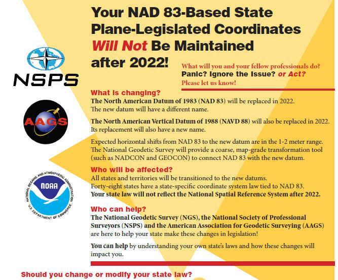
133
134 THE SHORTCOMING OF NAD 83.
")
135 MOVE GEOCENTER TO IGS GEOCENTER AT SOME EPOCH OF TIME. COORDINATES WILL BE IDENTICAL TO IGS AT THIS EPOCH OF TIME, BUT WILL THEN DIVERGE, BECAUSE: NATRF2022 WILL BE FIXED ON NORTH AMERICAN PLATE (RELATIVE TO ROTATION ABOUT THE EULER POLE) AND NOT CHANGE RELATIVE TO CRUSTAL MOTION. THERE WILL BE AN INTRA-FRAME VELOCITY MODEL (IFVM) TO ACCOUNT FOR NON-EULERIAN MOVEMENT.

136 IGS COORDINATES CHANGE WITH THESE VELOCITIES, NOT NATRF2022 COORDINATES NATRF2022 WILL HAVE SPATIAL COORDINATE STABILITY

137 NORTH AMERICAN PLATE CORS ROTATION IFVM


138 SILVER SPRING, MD ITRF 2000 NAD 83

139 NAD 83 VELOCITIES (GOLD) SANTA CRUZ, CA ITRF 2000 VELOCITIES (BLUE)

")
140 ELLIPSOID HEIGHT SHIFTS Approximate IGS08(GRS-80) minus NAD 83(2011)


141 Approximate IGS08(GRS-80) minus NAD 83(2011) HORIZONTAL SHIFTS Lat: Lon:

142
143 CHANGE IN h
144 THE SHORTCOMING OF NAVD 88. WHY ISN T NAVD 88 GOOD ENOUGH ANYMORE? 1. BIASED TO THE GLOBAL GEOID MODEL BY ABOUT 0.5 M 2. BENCH MARKS ARE ALMOST NEVER RE-CHECKED FOR MOVEMENT 3. DISAPPEAR BY THE THOUSANDS EVERY YEAR 4. WERE DETERMINED BY LEVELING FROM A SINGLE POINT, ALLOWING CROSS-COUNTRY ERROR BUILD UP (~ 1 METER) ARE NOT FUNDED FOR REPLACEMENT ARE NOT NECESSARILY IN CONVENIENT PLACES DON T EXIST IN MOST OF ALASKA WEREN T ADOPTED IN CANADA RE-LEVELING WOULD COST 200 MILLION TO 2 BILLION $$


145 THE PROBLEM WITH PASSIVE MARKS.
146 .THE TILT OF NAVD 88 RELATIVE TO THE GRAVIMETRIC GEOID NAVD 88 =
147 BASED ON PURE GRAVIMETRIC GEOID, ACCURATE TO 1 CM VIA GRAV-D PROJECT VERTICAL DATUM BROUGHT TO SITE AT 2 CM IN WELL- MODELED AREAS. ACCURACY (ALLOWS 1 CM h ERROR) ACCESSABILITY: BROUGHT TO A PROJECT SITE VIA ACTIVE REFERENCE STATIONS (NATIONAL CORS) DENSIFIED TO PROJECT ACCURACY NEEDS AT SITE (E.G., DIGITAL LEVELING). NAVD 88 WILL BE ABOUT 1.2 GREATER IN VALUE THAN THE NEW VERTICAL DATUM IN PENNSYLVANIA


148 0 ANTENNA HEIGHT RETURNS THE ARP

149 REPLACE NAVD 88 CHANGING FROM A LEVELING-BASED TO A GEOID/GNSS-BASED VERTICAL DATUM BIGGEST REQUIREMENT: AN UPDATED, ACCURATE, NATIONWIDE GRAVITY SURVEY AIRBORNE GRAV-D! GRAVITY FOR THE REDEFINITION OF THE AMERICAN VERTICAL DATUM

150 GRAV-D COVERAGE ALASKA CONUS GUAM/NORTHERN MARIANAS HAWAI I PUERTO RICO/VIRGIN ISLANDS AMERICAN SAMOA

151

152

153 TIME DEPENDENCIES - GEOID CHANGES CAUSE HEIGHT CHANGES THE ZERO ELEVATION SURFACE WILL CHANGE WITH TIME HEIGHTS WILL BE TIME TAGGED TO RESPECT: GEOID CHANGE SUBSIDENCE

154
155 USING NATRF2022 ELLIPSOID HEIGHTS WITH THE GRAVIMETRIC GEOID FOR NAPGD2022 ORTHO HEIGHTS H 88 = h 83 N 12a H 22 = h 22 N USGG USING THE GRAVIMETRIC GEOID
156 WHAT ABOUT THE PASSIVE MARKS? SECONDARY ACCESS (USE AT YOUR OWN RISK) USE PASSIVE MARKS THAT HAVE BEEN TIED TO THE NEW VERTICAL DATUM NGS WILL PROVIDE A DATA SHARING SERVICE FOR THESE POINTS, BUT THEIR ACCURACY (DUE TO EITHER THE QUALITY OF THE SURVEY OR THE AGE OF THE DATA) WILL NOT BE A RESPONSIBILITY OF NGS

157 WHAT ABOUT CONVERTING TO/FROM NAVD 88? A CONVERSION WILL BE PROVIDED BETWEEN NAVD 88 AND THE NEW DATUM ONLY WHERE RECENT GNSS ELLIPSOID HEIGHTS EXIST TO PROVIDE MODERN HEIGHTS IN THE NEW DATUM


158
 NAD 83")
 + GEOID 12a = SPC N,E,H")


159 GNSS TO ANY DATUM GNSS ECEF X,Y,Z (WGS 84 & PZ90) NAD 83 (,,h) SPC N,E,h NATRF2022 (,,h) + GEOID 12a = SPC N,E,H GEOID USGG 22 OR CALIBRATE TO 4-5 SITE POINTS IN THE DESIRED DATUM. THIS IS USED TO LOCK TO PASSIVE MONUMENTATION IN THE PROJECT AREA.
160 THOUGHTS. FOR VERTICAL DATUMS OTHER THAN NAVD 88 (AND SOON NAPGD2022) - RECOMMEND PERFORMING PROJECT SURVEY IN THE CURRENT DATUM AND THEN CALCULATING AN OFFSET BETWEEN THE DATUMS FOR ALL CONTROL POINTS. IF THERE ARE SUFFICIENT MARKS IN THE LEGACY DATUM, A BEST FIT LOCALIZATION CAN BE ACCOMPLISHED. NATIONAL BACKBONE CORS OWNED & MAINTAINED BY NGS WILL BE THE HORIZONTAL AND VERTICAL TRUTH FOR OUR DATUMS AND THUS REQUIRE REMOTE ACCESS. A TIME DEPENDENT GEOID WILL MAINTAIN 1-CM ACCURACY IN WELL-MODELED AREAS AND THUS ENABLE 2-CM VERTICAL ACCURACY TO THE DATUM. KEEP ALL GNSS OBSERVATION DATA. IT CAN BE USED TO RECALCULATE POSITIONS IN ANY DATUM IN THE FUTURE. CONVERSIONS ARE NOTORIOUSLY INACCURATE. MAKE SURE YOUR PLATS, DRAWINGS, ETC. HAVE THE PROPER METADATA FOR FUTURE SURVEYORS TO USE IN THEIR WORK.

161
BILL HENNING, Prof LS. ACRONYMS
 BILL HENNING, Prof LS. ACRONYMS US 1 WIKIPEDIA: Also known as geodetics, geodetic engineering or geodetics engineering a branch of applied mathematics [2] and earth sciences, is the scientific discipline
ELEMENTS OF THE NATIONAL SPATIAL REFERENCE SYSTEM
 Dave Doyle NGS Chief Geodetic Surveyor dave.doyle@noaa.gov 301-713-3178 ELEMENTS OF THE NATIONAL SPATIAL REFERENCE SYSTEM ESRI SURVEY SUMMIT San Diego, CA June 17, 2007 ftp://ftp.ngs.noaa.gov/dist/daved/esri
An NGS Illustrated Guide to Geodesy for GIS Professionals
 An NGS Illustrated Guide to Geodesy for GIS Professionals Michael Dennis, RLS, PE michael.dennis@noaa.gov Esri User Conference San Diego Convention Center July 14-18, 2014 San Diego, CA Why should we care
Overview of New Datums
 Overview of New Datums Scott Lokken NC Advisor NOAA s National Geodetic Survey 9/4/2015 1 New Datums are Coming in 2022! Both a new geometric and a new geopotential (vertical) datum will be released in
Determining Accurate Elevations: Datums & Tools, Today & Tomorrow
 Determining Accurate Elevations: Datums & Tools, Today & Tomorrow Association of State Floodplain Managers Annual Meeting Grand Rapids, MI Christine Gallagher June 21, 2016 Overview NGS Mission Important
NSRS Modernization Update
 geodesy.noaa.gov NSRS Modernization Update Scott Lokken National Geodetic Survey, NOAA Mid Atlantic Regional Geodetic Advisor Oct 05, 2017 Maryland Society of Surveyors Fall Conference NGS Regional Geodetic
Lecture 16 NAD 83 (1986), NAD 83(1993) and NAD 83 (NSRS 2007) 10 March 2009 GISC3325
, NAD 83(1993) and NAD 83 (NSRS 2007) 10 March 2009 GISC3325") Lecture 16 NAD 83 (1986), NAD 83(1993) and NAD 83 (NSRS 2007) 10 March 2009 GISC3325 Significant dates 16-20 March 2009 is Spring Break 12 March 2009 is Exam Two Emphasis on chapter 5, 6 and 8 of text
Lecture 16 NAD 83 (1986), NAD 83(1993) and NAD 83 (NSRS 2007) 10 March 2009 GISC3325 Significant dates 16-20 March 2009 is Spring Break 12 March 2009 is Exam Two Emphasis on chapter 5, 6 and 8 of text
Overview of New Datums NOAA s National Geodetic Survey
 Overview of New Datums NOAA s National Geodetic Survey February 3, 2015 1 NGS s Mission and Role NGS Mission: To define, maintain, and provide access to the National Spatial Reference System to meet our
Determining Accurate Elevations: Datums & Tools, Today & Tomorrow
 Determining Accurate Elevations: Datums & Tools, Today & Tomorrow Maryland Association Floodplain and Stormwater Managers Linthicum Heights, MD Christine Gallagher Oct. 20, 2016 Overview NGS Mission Important
Geodesy, Geographic Datums & Coordinate Systems
 Geodesy, Geographic Datums & Coordinate Systems What is the shape of the earth? Why is it relevant for GIS? 1/23/2018 2-1 From Conceptual to Pragmatic Dividing a sphere into a stack of pancakes (latitude)
Lecture 14 NAD 83(NSRS), NAD 83(CORS 96), WGS84 and ITRF
, NAD 83(CORS 96), WGS84 and ITRF") Lecture 14 NAD 83(NSRS), NAD 83(CORS 96), WGS84 and ITRF Monday, March 1, 2010 2 March 2010 GISC3325 NAD 27 and NAD 83 NAD 27 and NAD 83 Versions of NAD 83 First implementation labeled NAD 83 (1986). Deficiencies
Lecture 14 NAD 83(NSRS), NAD 83(CORS 96), WGS84 and ITRF Monday, March 1, 2010 2 March 2010 GISC3325 NAD 27 and NAD 83 NAD 27 and NAD 83 Versions of NAD 83 First implementation labeled NAD 83 (1986). Deficiencies
Datums and Tools to Connect Geospatial Data Accurately
 Datums and Tools to Connect Geospatial Data Accurately Pamela Fromhertz Colorado State Geodetic Advisor National Geodetic Survey National Oceanic and Atmospheric Administration GIS-T April 18, 2012 Loveland,
Lecture # 7 Coordinate systems and georeferencing
 Lecture # 7 Coordinate systems and georeferencing Coordinate Systems Coordinate reference on a plane Coordinate reference on a sphere Coordinate reference on a plane Coordinates are a convenient way of
High Precision GNSS for Mapping & GIS Professionals
 High Precision GNSS for Mapping & GIS Professionals Agenda Address your needs for GNSS knowledge. GNSS Basics Satellite Ranging Fundamentals (Code $ Carrier) Differential Corrections (Post Processed $
Benefits and Impacts to Nautical Charting by Adopting a New Reference Frame. Dr. Neil Weston Office of Coast Survey, NOAA
 Benefits and Impacts to Nautical Charting by Adopting a New Reference Frame Dr. Neil Weston Office of Coast Survey, NOAA Motivation for this study NOAA s National Geodetic Survey New geometric reference
Introduction to Datums James R. Clynch February 2006
 Introduction to Datums James R. Clynch February 2006 I. What Are Datums in Geodesy and Mapping? A datum is the traditional answer to the practical problem of making an accurate map. If you do not have
Overview of Tides and Water Levels
 Overview of Tides and Water Levels www.tidesandcurrents.noaa.gov New Orleans, Baton Rouge, Lafayette, LA March 2009 Gerald Hovis, NOAA - National Ocean Service William Sweet, NOAA - National Ocean Service
FieldGenius Technical Notes GPS Terminology
 FieldGenius Technical Notes GPS Terminology Almanac A set of Keplerian orbital parameters which allow the satellite positions to be predicted into the future. Ambiguity An integer value of the number of
Datum Transformations: Nightmare on GIS Street. Agenda
 Datum Transformations: Nightmare on GIS Street Speaker: Eric Gakstatter Contributing Editor GPS World Editor - Geospatial Solutions Presented at: Minnesota Society of Professional Surveyors Bloomington,
National Height Modernization: Cost comparison of conducting a vertical survey by leveling versus by GPS in western North Carolina
 Introduction: National Height Modernization: Cost comparison of conducting a vertical survey by leveling versus by GPS in western North Carolina The North Carolina Geodetic Survey (NCGS) conducted a National
Understanding the Evolution of WGS 84 and NAD 83
 Summary Both WGS 84, the datum used by GPS,, commonly used in North America, have been redefined several times since their beginning. Parallel to this, there have also been several realizations of the
Modernization of the National Spatial Reference System Keeping Pace with Changes in Positioning Technology and User Expectations in a Dynamic World
 Modernization of the National Spatial Reference System Keeping Pace with Changes in Positioning Technology and User Expectations in a Dynamic World Wisconsin Society of Land Surveyors Institute Wisconsin
Appendix A Lower Columbia River Chart Datum Modeling
 Appendix A Lower Columbia River Chart Datum Modeling David Evans and Associates, Inc. David Evans and Associates, Inc. 2801 SE Columbia Way, Ste. 130 Vancouver, WA 98661 (360) 314-3200 1.0 Vertical Datum
Datums for a Dynamic Earth
 Datums for a Dynamic Earth Based on a paper given at the American Society of Agricultural and Biological Engineers (ASABE) Conference in Reno, Nevada June 2009 Rollin StrohmanPh.D. Tom Mastin L.S Background
NATIONAL VDATUM -- THE IMPLEMENTATION OF A NATIONAL VERTICAL DATUM TRANSFORMATION DATABASE
 NATIONAL VDATUM -- THE IMPLEMENTATION OF A NATIONAL VERTICAL DATUM TRANSFORMATION DATABASE Bruce Parker, Dennis Milbert, Kurt Hess, and Stephen Gill National Ocean Service, NOAA The National Ocean Service
Utilizing A GNSS Network Solution for Utility Applications
 Utilizing A GNSS Network Solution for Utility Applications David Newcomer, PE, PLS GPServ, Inc. newcomer@ (407) 601-5816 AGENDA Types and accuracies of data collection o Autonomous o Meter + o Sub-meter
WISCONSIN COORDINATE SYSTEMS
 Pdf versions of the Handout and Powerpoint slides are on jerrymahun.com. Follow the USPLSS Forum link and use the password: WildT2 WISCONSIN COORDINATE SYSTEMS CONCEPTS & IMPLEMENTATION Jerry Mahun, PLS,
Application of GPS/GNSS in Cybermapping. Cybermapping Lab University of Texas at Dallas 2009
 Application of GPS/GNSS in Cybermapping Cybermapping Lab University of Texas at Dallas 2009 GNSS Global Navigation Satellite System (GNSS) is the standard generic term for satellite navigation systems
GNSS & Coordinate Systems
 GNSS & Coordinate Systems Matthew McAdam, Marcelo Santos University of New Brunswick, Department of Geodesy and Geomatics Engineering, Fredericton, NB May 29, 2012 Santos, 2004 msantos@unb.ca 1 GNSS GNSS
GPS Geodetic Reference System WGS 84
 GPS Geodetic Reference System WGS 84 International Committee on GNSS Working Group D Saint Petersburg, Russia 16 September 2009 Barbara Wiley National Geospatial-Intelligence Agency United States of America
21st International Conference of The Coastal Society
 21st International Conference of The Coastal Society DEVELOPMENT OF A VERTICAL DATUM TRANSFORMATION TOOL AND A BATHYMETRIC/TOPOGRAPHIC DIGITAL ELEVATION MODEL FOR SOUTHERN CALIFORNIA Edward P. Myers, NOAA/NOS
CHAPTER 3. BASIC GEODESY
 CHAPTER 3. BASIC GEODESY SECTION I. THE GEODETIC SYSTEM A geodetic system serves as a framework for determining coordinates on the Earth s surface with respect to a reference ellipsoid and the geoid. It
CHAPTER 2 GEODESY AND DATUMS IN NAVIGATION
 CHAPTER 2 GEODESY AND DATUMS IN NAVIGATION GEODESY, THE BASIS OF CARTOGRAPHY 200. Definition Geodesy is the application of mathematics to model the size and shape of the physical earth, enabling us to
IAG School on Reference Systems June 7 June 12, 2010 Aegean University, Department of Geography Mytilene, Lesvos Island, Greece SCHOOL PROGRAM
 IAG School on Reference Systems June 7 June 12, 2010 Aegean University, Department of Geography Mytilene, Lesvos Island, Greece SCHOOL PROGRAM Monday June 7 8:00-9:00 Registration 9:00-10:00 Opening Session
Basic Geodetics. Bobby Saleh Guidon Energy April 13, 2017
 Experts in Geomatics, Surveying, Positioning, Geospatial Data, and Mapping Sciences Basic Geodetics Bobby Saleh Guidon Energy b.saleh@guidonenergy.com April 13, 2017 The Earth is NOT flat Q: So what does
Overview of Recent Tidal Projects in the United States
 1 st Tides and Water Levels Working Group Meeting Overview of Recent Tidal Projects in the United States Stephen Gill National Oceanic and Atmospheric Administration, National Ocean Service Center for
GNSS 101 Bringing It Down To Earth
 GNSS 101 Bringing It Down To Earth Steve Richter Frontier Precision, Inc. UTM County Coordinates NGVD 29 State Plane Datums Scale Factors Projections Session Agenda GNSS History & Basic Theory Coordinate
Salient Feature of ITRF. Realization of Dubai Emirate Datum. Reference Frame 2000 (Ditr 2000)
") Salient Feature of ITRF on the Reference Frame 2000 (Ditr 2000) ITRF stands for International Terrestrial Reference Frame ITRF established by the International Earth Rotation Service (IERS), France. One
Salient Feature of ITRF on the Reference Frame 2000 (Ditr 2000) ITRF stands for International Terrestrial Reference Frame ITRF established by the International Earth Rotation Service (IERS), France. One
Geodetic Reference Frame Theory
 Technical Seminar Reference Frame in Practice, Geodetic Reference Frame Theory and the practical benefits of data sharing Geoffrey Blewitt University of Nevada, Reno, USA http://geodesy.unr.edu Sponsors:
Standard for the Australian Survey Control Network
 Standard for the Australian Survey Control Network Special Publication 1 Intergovernmental Committee on Survey and Mapping (ICSM) Geodesy Technical Sub-Committee (GTSC) 30 March 2012 Table of contents
New Zealand Reference Frame Case Study
 New Zealand Reference Frame Case Study Graeme Blick Chief Geodesist Land Information New Zealand 1 Fundamental role of the reference frame Requirements of a National Reference System A coordinate framework
VERTICAL DATUM TRANSFORMATIONS FOR KINEMATIC GPS HYDROGRAPHIC SURVEYS. Kurt W. Hess, Dennis G. Milbert, Stephen K. Gill, and Daniel R.
 VERTICAL DATUM TRANSFORMATIONS FOR KINEMATIC GPS HYDROGRAPHIC SURVEYS Kurt W. Hess, Dennis G. Milbert, Stephen K. Gill, and Daniel R. Roman National Ocean Service, NOAA ABSTRACT Kinematic Global Positioning
GPS for. Land Surveyors. Jan Van Sickle. Fourth Edition. CRC Press. Taylor & Francis Group. Taylor & Francis Croup, an Informa business
 GPS for Land Surveyors Fourth Edition Jan Van Sickle CRC Press Taylor & Francis Group Boca Raton London New York CRC Press is an imprint of the Taylor & Francis Croup, an Informa business Contents Preface
INTEGRATING BATHYMETRY, TOPOGRAPHY, AND SHORELINE, AND THE IMPORTANCE OF VERTICAL DATUMS
 INTEGRATING BATHYMETRY, TOPOGRAPHY, AND SHORELINE, AND THE IMPORTANCE OF VERTICAL DATUMS Bruce Parker, Dennis Milbert, Kurt Hess, and Stephen Gill National Ocean Service, NOAA 1315 East-West Highway Silver
CHAPTER 5 Vertical Control. CE 316 January 2012
 CHAPTER 5 Vertical Control CE 316 January 01 137 5.1 Introduction Vertical Datums Leveling Techniques and Corrections Bench Mark Design and Construction Bench Mark Data Trigonometric Barometric Leveling
Definition and use of the New Zealand Vertical Datum Matt Amos Senior Advisor Geodesy
 Definition and use of the New Zealand Vertical Datum 2009 Matt Amos Senior Advisor Geodesy NZIS Continuing Professional Development Programme, November 2009 Overview Height Theory Heights in New Zealand
CGG. Office of the Surveyor General of the Federation Federal Capital Territory, Abuja, Nigeria 2
 Prof. P. C. Nwilo 1, * Dr. J. D. Dodo 2, U. R. Edozie 1, and A. Adebomehin 1. 1 Office of the Surveyor General of the Federation Federal Capital Territory, Abuja, Nigeria 2 Centre for Geodesy and Geodynamics,
U.S. Army Corps of Engineers: Review of Progress Toward Consistent Vertical Datums. by Jim Garster and Mark Huber
 U.S. Army Corps of Engineers: Review of Progress Toward Consistent Vertical Datums by Jim Garster and Mark Huber i ii Abstract A vertical datum is the most important part of any geospatial data, no matter
Satellite Laser Retroreflectors for GNSS Satellites: ILRS Standard
 Satellite Laser Retroreflectors for GNSS Satellites: ILRS Standard Michael Pearlman Director Central Bureau International Laser Ranging Service Harvard-Smithsonian Center for Astrophysics Cambridge MA
Geodetic policy for Ireland and Northern Ireland
 Geodetic policy for Ireland and Northern Ireland Background Ordnance Survey Ireland (OSi) is the National Mapping Agency (NMA) of the Republic of Ireland. The Ordnance Survey of Northern Ireland (OSNI)
Coordinates, Datums, and Map Projection
 Coordinates, Datums, and Map Projection Two views on the World Intersect at 90 o angles Latitude/ Longitude is a Spherical System Acceptable latitudes/longitudes i) W125 o 27 33 ii) N92 o 45 12 iii)
The Global Positioning Sytem II 10/19/2017
 The Global Positioning System II Field Experiments 10/19/2017 5-1 Mexico DGPS Field Campaign Cenotes in Tamaulipas, MX, near Aldama 10/19/2017 5-2 Are Cenote Water Levels Related? 10/19/2017 5-3 M. Helper,
The Global Positioning System II Field Experiments
 The Global Positioning System II Field Experiments 5-1 Mexico DGPS Field Campaign Cenotes in Tamaulipas, MX, near Aldama 5-2 Are Cenote Water Levels Related? 5-3 DGPS Static Survey of Cenote Water Levels
DYNAMIC RT TECHNOLOGY
 DYNAMIC RT TECHNOLOGY GLOBAL NAVIGATION SATELLITE SYSTEMS (GNSS) POTENTIAL FUTURE DEVELOPMENTS(2005 2017?) GPS MODERNIZATION BLOCK IIF & III GLONASS ENHANCEMENTS (K & M) EUROPEAN UNION - GALILEO CHINA
GPS for crustal deformation studies. May 7, 2009
 GPS for crustal deformation studies May 7, 2009 High precision GPS for Geodesy Use precise orbit products (e.g., IGS or JPL) Use specialized modeling software GAMIT/GLOBK GIPSY OASIS BERNESE These software
Progress Towards the Seamless Combination of Bathymetric and Topographic Data in New Zealand
 Progress Towards the Seamless Combination of Bathymetric and Topographic Data in New Zealand Matt Amos Senior Technical Advisor National Geodetic Office Introduction Datasets usually defined in terms of
AUSPOS GPS Processing Report
 AUSPOS GPS Processing Report February 13, 2012 This document is a report of the GPS data processing undertaken by the AUSPOS Online GPS Processing Service (version: AUSPOS 2.02). The AUSPOS Online GPS
What makes the positioning infrastructure work. Simon Kwok Chairman, Land Surveying Division Hong Kong Institute of Surveyors
 What makes the positioning infrastructure work The experience of the Hong Kong Satellite Positioning Reference Station Network Simon Kwok Chairman, Land Surveying Division Hong Kong Institute of Surveyors
Choosing the best path:
 GEODESY Choosing the best path: Global to national coordinate transformations The paper demonstrates that differences of up to a few centimetres in each coordinate component can occur depending on the
GPS Technical Aspects
 GPS Technical Aspects Charles Ghilani (cghilani@psu.edu) Turn off all cell phones Or set them to vibrate Class Etiquette Ask questions at any point during the class. Simply speak up so that all can hear
CHAPTER 2 GEODESY AND DATUMS IN NAVIGATION
 CHAPTER 2 GEODESY AND DATUMS IN NAVIGATION GEODESY, THE BASIS OF CARTOGRAPHY 200. Definition Geodesy is the science concerned with the exact positioning of points on the surface of the earth. It also involves
Applications, Products and Services of GPS Technology
 Applications, Products and Services of GPS Technology Enrico C. Paringit. Dr. Eng. University of the Philippines Training Center for Applied Geodesy and Photogrammetry 1 Outline of this Presentation GPS
Using RTK GNSS Wisely
 Using RTK GNSS Wisely February 017 Autonomous Positioning Differential Positioning Concept: Detect and cancel identical errors with simultaneous observation. F + E = G + E 1 Static & RTK Computations Static
Standard for New Zealand Vertical Datum 2016 LINZS25009
 Standard for New Zealand Vertical Datum 2016 LINZS25009 Effective Date: 27 June 2016 Table of Contents TERMS ND DEFINITIONS... 3 FOREWORD... 5 INTRODUCTION... 5 PURPOSE OF STNDRD... 5 BRIEF HISTORY OF
Global IGS/GPS Contribution to ITRF
 Global IGS/GPS Contribution to ITRF R. Ferland Natural ResourcesCanada, Geodetic Survey Divin 46-61 Booth Street, Ottawa, Ontario, Canada. Tel: 1-613-99-42; Fax: 1-613-99-321. e-mail: ferland@geod.nrcan.gc.ca;
Update on the International Terrestrial Reference Frame (ITRF)
") Update on the International Terrestrial Reference Frame (ITRF) Zuheir Altamimi Head of the IERS ITRF Product Center Institut National de l Information Géographique et Forestière IGN, France E-mail: zuheir.altamimi@ign.fr
Update on the International Terrestrial Reference Frame (ITRF) Zuheir Altamimi Head of the IERS ITRF Product Center Institut National de l Information Géographique et Forestière IGN, France E-mail: zuheir.altamimi@ign.fr
GROUND CONTROL SURVEY REPORT
 GROUND CONTROL SURVEY REPORT Services provided by: 3001, INC. a Northrop Grumman company 10300 Eaton Place Suite 340 Fairfax, VA 22030 Ground Control Survey in Support of Topographic LIDAR, RGB Imagery
Other Space Geodetic Techniques. E. Calais Purdue University - EAS Department Civil 3273
 Other Space Geodetic Techniques E. Calais Purdue University - EAS Department Civil 3273 ecalais@purdue.edu Satellite Laser Ranging = SLR Measurement of distance (=range) between a ground station and a
MONITORING SEA LEVEL USING GPS
 38 MONITORING SEA LEVEL USING GPS Hasanuddin Z. Abidin* Abstract GPS (Global Positioning System) is a passive, all-weather satellite-based navigation and positioning system, which is designed to provide
Joining New Zealand Land and Sea Vertical Datums (JLAS) Graeme Blick Group Manager Positioning and Resilience
 Graeme Blick Group Manager Positioning and Resilience") Presented at the FIG Congress 2018, May 6-11, 2018 in Istanbul, Turkey Joining New Zealand Land and Sea Vertical Datums (JLAS) Graeme Blick Group Manager Positioning and Resilience Mapping NZ 2025 What
Presented at the FIG Congress 2018, May 6-11, 2018 in Istanbul, Turkey Joining New Zealand Land and Sea Vertical Datums (JLAS) Graeme Blick Group Manager Positioning and Resilience Mapping NZ 2025 What
GUIDELINES FOR MANAGING
 GUIDELINES FOR MANAGING A GPS BASED CONTROL SYSTEM IN THE MARITIME PROVINCES Version 1.0 prepared for Maritime GPS Implementation Committee prepared by Geoplan Consultants Inc. in association with Gillis
PREFACE. National Geographic Department would like to express our sincere thanks for your comments.
 PREFACE According to the role of National Geographic Department on Prim Minister s Decree No 255 PM, dated August 16, 2005 regarding to Surveying, Aerial Photography and mapping activities in the territory
LSD PQSL Series Geodetic Survey. Prepared by Mr KWOK King-hung 22 May 2015
 LSD PQSL Series 2015 Geodetic Survey Prepared by Mr KWOK King-hung 22 May 2015 1 Geodesy Source from Wiki May 2015 also known as geodetics or geodetics engineering a branch of applied mathematics and earth
Other Space Geodetic Techniques. E. Calais Purdue University - EAS Department Civil 3273
 Other Space Geodetic Techniques E. Calais Purdue University - EAS Department Civil 3273 ecalais@purdue.edu Satellite Laser Ranging Measurement of distance (=range) between a ground station and a satellite
Global Positioning Systems - GPS
 Global Positioning Systems - GPS GPS Why? What is it? How does it work? Differential GPS How can it help me? GPS Why?? Where am I? How do I get there? Where are you, and how do I get to You? WHO CARES???
WHAT WILL GNSS BE LIKE IN TEN YEARS?
 Bill Henning, PLS. Static GNSS vs. RTK GNSS RTN vs. RTK RTX vs. RTN PPP vs. differential processing OPUS-S vs. OPUS-RS vs. OPUS-P Passive vs. Active control Grid vs. Ground Precision vs. Accuracy RMS and
The realization of a 3D Reference System
 The realization of a 3D Reference System Standard techniques: topographic surveying and GNSS Observe angles and distances either between points on the Earth surface or to satellites and stars. Do not observe
GNSS: orbits, signals, and methods
 Part I GNSS: orbits, signals, and methods 1 GNSS ground and space segments Global Navigation Satellite Systems (GNSS) at the time of writing comprise four systems, two of which are fully operational and
Using GPS to Establish the NAVD88 Elevation on Reilly The A-order HARN Station at NMSU
 Using GPS to Establish the NAVD88 Elevation on Reilly The A-order HARN Station at NMSU Earl F. Burkholder, PS, PE New Mexico State University Las Cruces, NM 88003 July 005 Introduction GPS has become an
Global Positioning Systems -GPS
 Global Positioning Systems -GPS GPS Why? What is it? How does it work? Differential GPS How can it help me? GPS Why?? Where am I? How do I get there? Where are you, and how do I get to You? WHO CARES???
GPS and GNSS from the International Geosciences Perspective
 GPS and GNSS from the International Geosciences Perspective G. Beutler Astronomical Institute, University of Bern Member of IAG Executive Committee and of IGS Governing Board National Space-Based Positioning,
Philippine Geodetic Infrastructure Status, Challenges and Future Direction
 Philippine Geodetic Infrastructure Status, Challenges and Future Direction Engr. Charisma Victoria D. Cayapan National Mapping and Resource Information Authority PHILIPPINES Outline Evolution of Geodetic
Geodetic Positioning Refresher
 Geodetic Positioning Refresher by Joan Yau PhD ABCLS AGM 2016, Kimberley BC Contents Horizontal / Vertical Datums and Epochs used in BC and Canada How do we reference our project coordinates to BC datums
3. GENERAL TIDAL DATUM COMPUTATION PROCEDURES
 3. GENERAL TIDAL DATUM COMPUTATION PROCEDURES 3.1 Datum Computation Procedures Overview A vertical datum is termed a tidal datum when it is defined by a certain phase of the tide. Tidal datums are local
The Promise and Challenges of Accurate Low Latency GNSS for Environmental Monitoring and Response
 Technical Seminar Reference Frame in Practice, The Promise and Challenges of Accurate Low Latency GNSS for Environmental Monitoring and Response John LaBrecque Geohazards Focus Area Global Geodetic Observing
Development of Geoid Based Vertical Datums, A New Zealand Perspective
 Technical Seminar Reference Frame in Practice, Development of Geoid Based Vertical Datums, A New Zealand Perspective Matt Amos Manager Positioning and Innovation Land Information New Zealand Sponsors:
t =1 Transmitter #2 Figure 1-1 One Way Ranging Schematic
 1.0 Introduction OpenSource GPS is open source software that runs a GPS receiver based on the Zarlink GP2015 / GP2021 front end and digital processing chipset. It is a fully functional GPS receiver which
TECHNICAL REPORT NO. 45 TECHNICAL REVIEW AND REEVALUATION OF THE REGIONAL CONTROL SURVEY PROGRAM IN SOUTHEASTERN WISCONSIN
 TECHNICAL REPORT NO. 45 TECHNICAL REVIEW AND REEVALUATION OF THE REGIONAL CONTROL SURVEY PROGRAM IN SOUTHEASTERN WISCONSIN SOUTHEASTERN WISCONSIN REGIONAL PLANNING COMMISSION SOUTHEASTERN WISCONSIN REGIONAL
National Reference Systems of the RUSSIAN FEDERATION, used in GLONASS. including the user and fundamental segments
 National Reference Systems of the RUSSIAN FEDERATION, used in GLONASS. including the user and fundamental segments 8-th Meeting of the International Committee on Global Navigation Satellite Systems Dubai,
The Role of F.I.G. in Leading the Development of International Real-Time Positioning Guidelines
 The Role of F.I.G. in Leading the Development of International Real-Time Positioning Guidelines, USA Key Words: RTN, real-time, GNSS, Guidelines SUMMARY The rapid growth of real-time reference station
GNSS CORS in the Pacific
 GNSS CORS in the Pacific FIG References Frame in Practice Seminar Operational Aspects of GNSS CORS Technical Workshop Holiday Inn, Suva - Fiji PGSC Partnership Desk, GEM Division, Pacific Community (SPC)
GLOBAL POSITIONING SYSTEMS
 GLOBAL POSITIONING SYSTEMS GPS & GIS Fall 2017 Global Positioning Systems GPS is a general term for the navigation system consisting of 24-32 satellites orbiting the Earth, broadcasting data that allows
Who s heard of the GDA2020?
 Implications of a next generation datum in Australia on mining operations: A discussion. School of Civil & Environmental Engineering Craig Roberts Senior lecturer Surveying and Geospatial Engineering group
Principal Investigator Co-Principal Investigator Co-Principal Investigator Prof. Talat Ahmad Vice-Chancellor Jamia Millia Islamia Delhi
 Subject Paper No and Title Module No and Title Module Tag Geology Remote Sensing and GIS Concepts of Global Navigation Satellite RS & GIS XXXIII Principal Investigator Co-Principal Investigator Co-Principal
Basics of Satellite Navigation an Elementary Introduction Prof. Dr. Bernhard Hofmann-Wellenhof Graz, University of Technology, Austria
 Basics of Satellite Navigation an Elementary Introduction Prof. Dr. Bernhard Hofmann-Wellenhof Graz, University of Technology, Austria Basic principles 1.1 Definitions Satellite geodesy (SG) comprises
GPS STATIC-PPP POSITIONING ACCURACY VARIATION WITH OBSERVATION RECORDING INTERVAL FOR HYDROGRAPHIC APPLICATIONS (ASWAN, EGYPT)
") GPS STATIC-PPP POSITIONING ACCURACY VARIATION WITH OBSERVATION RECORDING INTERVAL FOR HYDROGRAPHIC APPLICATIONS (ASWAN, EGYPT) Ashraf Farah Associate Professor,College of Engineering, Aswan University,
GPS STATIC-PPP POSITIONING ACCURACY VARIATION WITH OBSERVATION RECORDING INTERVAL FOR HYDROGRAPHIC APPLICATIONS (ASWAN, EGYPT) Ashraf Farah Associate Professor,College of Engineering, Aswan University,
PROPOSED NATIONAL GEODETIC DATABASE (NGDB) Coordinates. Orthometric Height Source
 Coordinates. Orthometric Height Source") Stations Name1, Name2, Name3 Custodian Orthometric Height Height Identifier MSL/AHD height Vert Class, Vert order, Ht method Supersedes, superseded by (double linked list AHD/MSL datum COMMENTS Fieldbooks
Stations Name1, Name2, Name3 Custodian Orthometric Height Height Identifier MSL/AHD height Vert Class, Vert order, Ht method Supersedes, superseded by (double linked list AHD/MSL datum COMMENTS Fieldbooks
GPS and Recent Alternatives for Localisation. Dr. Thierry Peynot Australian Centre for Field Robotics The University of Sydney
 GPS and Recent Alternatives for Localisation Dr. Thierry Peynot Australian Centre for Field Robotics The University of Sydney Global Positioning System (GPS) All-weather and continuous signal system designed
VLBI and DDOR activities at ESOC
 VLBI and DDOR activities at ESOC Claudia Flohrer 1, Mattia Mercolino 2, Erik Schönemann 1, Tim Springer 1, Joachim Feltens 1, René Zandbergen 1, Werner Enderle 1, Trevor Morley 3 1) Navigation Support
Suveying Lectures for CE 498
 Suveying Lectures for CE 498 SURVEYING CLASSIFICATIONS Surveying work can be classified as follows: 1- Preliminary Surveying In this surveying the detailed data are collected by determining its locations