CGG. Office of the Surveyor General of the Federation Federal Capital Territory, Abuja, Nigeria 2
|
|
|
- Jordan Bailey
- 6 years ago
- Views:
Transcription

1 Prof. P. C. Nwilo 1, * Dr. J. D. Dodo 2, U. R. Edozie 1, and A. Adebomehin 1. 1 Office of the Surveyor General of the Federation Federal Capital Territory, Abuja, Nigeria 2 Centre for Geodesy and Geodynamics, National Space Research and Development Agency, Toro, Bauchi State, Nigeria; *jd.dodo@gmail.com (Corresponding Author) Outline Introduction Implementation of Geocentric Datum for Nigeria Coordination of NIGNET to ITRF2008 as a Zero Order Geodetic Network Coordination of the Nigerian Primary Geodetic Network (NPGN) Data Processing Results and Analysis Conclusion 1

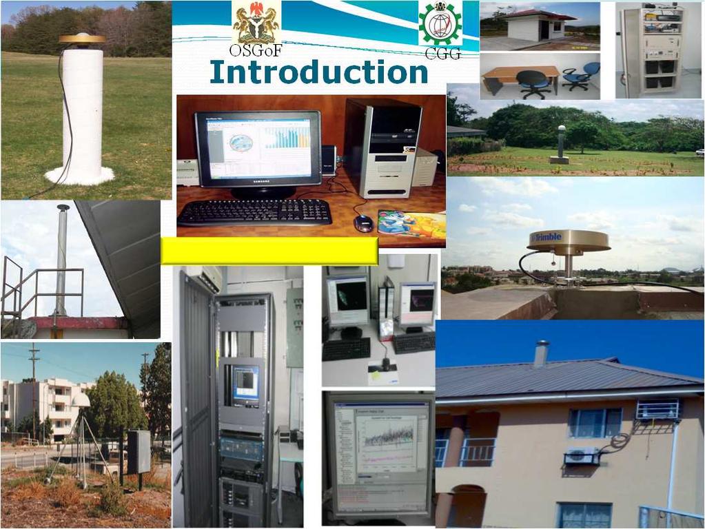
2 Introduction Traditional Survey Monuments Introduction What is the Problem? Traditionally each country has its own geodetic reference system resulting in non compatible coordinates systems between countries Most of them were confined to small areas of the globe, fit to limited areas to satisfy national mapping requirements. Maps in neighbouring countries do not match at the national boundaries (system1 ) (system2) 2
 National systems Introduction Solution As we move towards the adoption of universal reference")
3 (Country 2 map) What is the Problem? (country 1 map) National systems Introduction Solution As we move towards the adoption of universal reference frame we need: Maps that are uniform across national boundaries Global systems 3


4 Introduction Uniform system Non-uniform systems GNSS + ITRF Introduction Space Science and Technology 4

5 Introduction GNSS Infrastructure GNSS Network 5
6 Introduction AFREF To establish a continental reference system as a basis for national 3-D reference networks. To realize a unified vertical datum and to support efforts to establish a precise African geoid. To establish continuous, permanent GPS base stations at a spacing such that the users will be within 500km of a base station and that data is freely available to all users. Introduction Office of the Surveyor General of the Federation Responsible for the maintenance of the national reference system on which all survey and mapping is based. Set up surveying infrastructure throughout the country known as the Nigerian Permanent GNSS Network (NIGNET). The NIGNET is a network of GNSS Continuously Operating Reference Stations (CORS) operating 24 hours a day, which provides positional solutions. 6
 The Nigerian Geocentric Datum (NGD2012) is to be the new national geodetic datum for Nigeria.")
7 Introduction Office of the Surveyor General of the Federation In view of this embarked in the year 2008 on the Global Navigation Satellite Systems (GNSS) technology with the objective of adopting a global unified datum for Nigeria and the transformation of same to the old datum (Minna Datum) The Nigerian Geocentric Datum (NGD2012) is to be the new national geodetic datum for Nigeria. It will eventually replace the old Minna Datum of Clarke 1880 Implementation of Geocentric Datum for Nigeria (NGD2012) The development of NGD2012 began: with the establishment of the zero-order network of permanent GPS stations known as the Nigerian Permanent GNSS Network (NIGNET) the establishment of Nigerian Primary Geodetic Network 2011 by strengthening the Nigerian Triangulation Network of 1960s via a GPS campaign at selected stations to form a connection to the NIGNET network. 7

8 Implementation of Geocentric Datum for Nigeria (NGD2012) The development of NGD2012 Data processing and adjustment of Zero Order Geodetic Network. Computation of the new geocentric datum coordinates at a specific epoch. Derivation of transformation parameters. Coordination of NIGNET to ITRF2008 as a Zero Order Geodetic Network The ITRF2008 has a precision of a few millimetres and forms a robust basis for any regional or national geodetic datum. The present estimated accuracy of the coordinates is about 2 to 5mm in position and 1 to 2mm/yr in velocity. The stability of the frame over 10 years is reported to be accurate to better than 0.5 ppb in scale or equivalent to a shift of about 3mm in station height and 4mm in origin (Altamimi, et al, 2007). 8


9 Data Acquisition 2 years Data 9 IGS STATIONS Station ID Station location Country Appro. Lat (N) Apro. Long (N) Ellipsoidal Height (m) HARB Pretoria Republic of south Africa NKLG Libreville Gabon RABT Rabat Morocco RBAY Richards bay South Africa SUTH Sutherland South Africa CAGZ Capoterra Italy MAS1 maspalomas Spain NOT1 Noto Italy SFER sanfernando Spain IGS Stations used as fixed station for NIGNET Data Acquisition 13 BKFP 12 MDGR 11 ABUZ 11 NIGNET STATIONS Latitude OSGF T GEMB FUTY 2 years Data ULAG UNEC NIGNET CORS 5 RUST CLBR Longitude The Nigerian Permanent GNSS Reference Network (NIGNET) 9
10 Data Acquisition GPS Campaigns Year Jan Feb Mar Apr May Jun Jul Aug Sep Oct Nov Dec session session Data Processing Software used The Bernese GPS Scientific Software version
11 Data Processing The GPS data processing is divided into three parts namely Pre-processing Daily Adjustment and Weekly combination. Processing Parameters Daily pre-processing was preformed to eliminate satellite clock biases, estimate receiver clock correction, and to screen for cycle slips. Quasi Ionosphere Free strategy has been used for the ambiguity fixing with the average resolved ambiguity at around 75%. Data Processing Processing Parameters RINEX data at 30 second sampling rate IGS final orbit 24 hours sliding window processing ITRF 2008 reference frame Cut-off satellite elevation angle at 10 0 Quasi-Ionosphere free ( L 3 ) ambiguity free Saastamoinen Troposphere model IGS fixed stations Neil Mapping Function Free network adjustment Constrain Network adjustment Ocean Tide Loading for each station [FE2004] 11
12 Results and Analysis The daily solutions of independent baselines were computed using carrier phase double difference with Dry Neill Mapping Function for troposphere that was estimated for every two hours. Analysis of the weekly solutions were carried out to exclude bad station solutions based on both free and heavily constrained (with respect to the 9 IGS stations) network adjustment. Results and Analysis Final Combined Solution Two strategies were employed to obtain optimal results and to check for outliers in the final adjustment. The two strategies are as follow: Free Network Adjustment with introduction of Helmert Transformation Heavily Constrained Adjustment 12
13 Results and Analysis Free Network Adjustment The objective of the free network adjustment with the introduction of Helmert transformation was to adjust the weekly normal equation freely and transform them using the nine (9) IGS station for determining the NIGNET station coordinate; while the Eleven (11) NIGNET Stations were subsequently used to determine the sixty (60) GPS monument station coordinates. This process allowed for the internal reliability investigation and to detect outliers. With the introduction of reference velocity for the fixed stations, the final coordinates for all stations were transformed to the middle of the observation epoch. Results and Analysis Free Network Adjustment IGS Stations 13


14 Results and Analysis Free Network Adjustment 7.5 to 17.5 mm in the horizontal component and 16 to 20 mm in height component. Results and Analysis Heavily Constrained Adjustment 1 to 4 mm in horizontal component and 2 to 5 mm in the height component. 14
15 Results and Analysis Free Network Adjustment versus Heavily Constrained Adjustment The two coordinates set fits nicely Coordination of the Nigerian Primary Geodetic Network (NPGN) GPS observations were carried out on some existing Nigerian Primary Triangulation stations, while some stations were re-established. A GPS campaign was carried out from October 2010 to April A total of 60 stations were observed for a period of 48 hours to form the strengthening network. These stations were connected to the Zero Order Geodetic Network (NIGNET) and thus defining a new Nigerian Primary Geodetic Network (NPGN) based on NGD2012 reference frame. 15
16 Coordination of the Nigerian Primary Geodetic Network (NPGN) The observed data from the sixty (60) GPS monuments were processed using the same NIGNET stations processing procedure. The strengthening of the network involved two stages The Free network and the heavily constrain network adjustment. In the constrained adjustment, NIGNET stations held fixed to adjust the observed baseline vectors to obtain the link station s coordinates to conform to NGD2012. Coordination of the Nigerian Primary Geodetic Network (NPGN) The new NPGN has been successfully established with connection to the Zero Order Geodetic Network and its coordinates referred to the ITRF2008 Epoch 00.0 with an accuracy of 1 to 10mm. Quality assessment for network shows that differences less than 10 mm is achieved. Only one station in NPGN could not be processed due to poor data quality. 16
17 Coordination of the Nigerian Primary Geodetic Network (NPGN) Latitude XB92 R16A BKFP PIL7 0R7A 0D29 0D17 D12A L18A 00L8 0L16 0L10 CFA3 0X7A ULAG 0R28 0R36 00X5 00X4 0R43 N127 N133 CFL5 CF48 MDGR K17A 0A39 ABUZ N120 D35A 0A24 K38A 0B2A T 0B9A 00X3 0A16 N102 FUTY L29A 0E5A 0E10 OSGF 0A10 ON25 C40A 00F7 00P6 0H11 0U73 0U70 0C32 00H5 0P4A 0P15 00X1 00H4 00X6 0U81 0U78 GEMB 00C3 UNEC 0C16 CBL1 XV55 CLBR NATIONAL GPS Stations (Monument) RUST MW60 ZVS Longitude The Geocentric Datum Map of Nigeria Latitude XB92 R16A BKFP PIL7 0R7A 0D29 0D17 D12A L18A 00L8 0L16 0L10 CFA3 0X7A ULAG 0R28 0R36 00X5 00X4 0R43 N127 N133 CFL5 CF48 MDGR K17A 0A39 ABUZ N120 D35A 0A24 K38A 0B2A T 0B9A 00X3 0A16 N102 FUTY L29A 0E5A 0E10 OSGF 0A10 ON25 C40A 00F7 00P6 0H11 0U73 0U70 0C32 00H5 0P4A 0P15 00X1 00H4 00X6 0U81 GEMB 0U78 00C3 UNEC 0C16 XV55 NIGNET CORS CBL1 CLBR NATIONAL GPS Stations (Monument) RUST MW60 ZVS Longitude 17
18 Conclusion The Nigerian Geocentric Datum NGD2012 is a fulfilment of the African Reference Frame (AFREF) vision. With an accuracy of 10 mm defined in ITRF2008, it will form the backbone for all surveying and mapping activities. High Quality Coordinates of NIGNET Stations obtained The Zero Order Geodetic Network is to be finally defined on ITRF2008 reference frame. Conclusion A new geodetic datum known as Nigerian Geocentric Datum (NGD2012) is underway!!!!!!!!!!! 18


19 Thank you 19
The Nigerian Geocentric Datum (NGD2012): Preliminary Results
: Preliminary Results") Peter C. NWILO, Joseph D. DODO, Reuben U. EDOZIE, and Adeyemi, ADEBOMEHIN, Nigeria. Key words: NIGNET, ITRF, Geocentric Datum, GNSS, Nigerian Primary Geodetic Network, SUMMARY The Office of the Surveyor
Peter C. NWILO, Joseph D. DODO, Reuben U. EDOZIE, and Adeyemi, ADEBOMEHIN, Nigeria. Key words: NIGNET, ITRF, Geocentric Datum, GNSS, Nigerian Primary Geodetic Network, SUMMARY The Office of the Surveyor
ITRF 2008 Realization of the Nigerian Geocentric Datum (GDN2012): Preliminary Results
: Preliminary Results") Journal of Emerging Trends in Engineering and Applied Sciences (JETEAS) 2 (6): 978-986 Scholarlink Research Institute Journals, 2011 (ISSN: 2141-7016) jeteas.scholarlinkresearch.org Journal of Emerging
Journal of Emerging Trends in Engineering and Applied Sciences (JETEAS) 2 (6): 978-986 Scholarlink Research Institute Journals, 2011 (ISSN: 2141-7016) jeteas.scholarlinkresearch.org Journal of Emerging
AUSPOS GPS Processing Report
 AUSPOS GPS Processing Report February 13, 2012 This document is a report of the GPS data processing undertaken by the AUSPOS Online GPS Processing Service (version: AUSPOS 2.02). The AUSPOS Online GPS
Salient Feature of ITRF. Realization of Dubai Emirate Datum. Reference Frame 2000 (Ditr 2000)
") Salient Feature of ITRF on the Reference Frame 2000 (Ditr 2000) ITRF stands for International Terrestrial Reference Frame ITRF established by the International Earth Rotation Service (IERS), France. One
Salient Feature of ITRF on the Reference Frame 2000 (Ditr 2000) ITRF stands for International Terrestrial Reference Frame ITRF established by the International Earth Rotation Service (IERS), France. One
Bernese GPS Software 4.2
 Bernese GPS Software 4.2 Introduction Signal Processing Geodetic Use Details of modules Bernese GPS Software 4.2 Highest Accuracy GPS Surveys Research and Education Big Permanent GPS arrays Commercial
ELEMENTS OF THE NATIONAL SPATIAL REFERENCE SYSTEM
 Dave Doyle NGS Chief Geodetic Surveyor dave.doyle@noaa.gov 301-713-3178 ELEMENTS OF THE NATIONAL SPATIAL REFERENCE SYSTEM ESRI SURVEY SUMMIT San Diego, CA June 17, 2007 ftp://ftp.ngs.noaa.gov/dist/daved/esri
Presentation Plan. The Test of Processing Modules of Global Positioning System (GPS) Softwares by Using Products of International GPS Service (IGS)
 Softwares by Using Products of International GPS Service (IGS)") The Test of Processing Modules of Global Positioning System (GPS) Softwares by Using Products of International GPS Service (IGS) Presentation Plan 1. Introduction 2. Application 3. Conclusions Ismail SANLIOGLU,
The Test of Processing Modules of Global Positioning System (GPS) Softwares by Using Products of International GPS Service (IGS) Presentation Plan 1. Introduction 2. Application 3. Conclusions Ismail SANLIOGLU,
Record 2013/01 GeoCat 75057
 Record 2013/01 GeoCat 75057 Determination of GDA94 coordinates for station CCMB at the Clermont Coal Mine of Rio Tinto Coal Australia (RTCA) in central Queensland using the October and November 2012 GPS
GPS for crustal deformation studies. May 7, 2009
 GPS for crustal deformation studies May 7, 2009 High precision GPS for Geodesy Use precise orbit products (e.g., IGS or JPL) Use specialized modeling software GAMIT/GLOBK GIPSY OASIS BERNESE These software
Record 2013/06 GeoCat 75084
 Record 2013/06 GeoCat 75084 Determination of GDA94 coordinates for station CAVL at the Caval Ridge Mine of RPS Australia East Pty Ltd in Queensland using the November 2012 GPS data set G. Hu, J. Dawson
Utilizing A GNSS Network Solution for Utility Applications
 Utilizing A GNSS Network Solution for Utility Applications David Newcomer, PE, PLS GPServ, Inc. newcomer@ (407) 601-5816 AGENDA Types and accuracies of data collection o Autonomous o Meter + o Sub-meter
Record 2012/76 GeoCat 74975
 Record 2012/76 GeoCat 74975 Determination of GDA94 coordinates for station GRBA at the Goonyella Riverside Mine of the BHP Billiton Mitsubishi Alliance (BMA) in central Queensland using the September and
Record 2011/02. GeoCat # M. Jia, J. Dawson APPLYING GEOSCIENCE TO AUSTR ALIA S MOST IMPORTANT CHALLENGES
 G E O S C I E N C E A U S T R A L I A Correction to Determination of GDA94 coordinates for eleven Queensland Department of Environment and Resource Management CORS stations using the August 2010 GPS data
What makes the positioning infrastructure work. Simon Kwok Chairman, Land Surveying Division Hong Kong Institute of Surveyors
 What makes the positioning infrastructure work The experience of the Hong Kong Satellite Positioning Reference Station Network Simon Kwok Chairman, Land Surveying Division Hong Kong Institute of Surveyors
Guochang Xu GPS. Theory, Algorithms and Applications. Second Edition. With 59 Figures. Sprin ger
 Guochang Xu GPS Theory, Algorithms and Applications Second Edition With 59 Figures Sprin ger Contents 1 Introduction 1 1.1 AKeyNoteofGPS 2 1.2 A Brief Message About GLONASS 3 1.3 Basic Information of Galileo
Lecture # 7 Coordinate systems and georeferencing
 Lecture # 7 Coordinate systems and georeferencing Coordinate Systems Coordinate reference on a plane Coordinate reference on a sphere Coordinate reference on a plane Coordinates are a convenient way of
GPS for. Land Surveyors. Jan Van Sickle. Fourth Edition. CRC Press. Taylor & Francis Group. Taylor & Francis Croup, an Informa business
 GPS for Land Surveyors Fourth Edition Jan Van Sickle CRC Press Taylor & Francis Group Boca Raton London New York CRC Press is an imprint of the Taylor & Francis Croup, an Informa business Contents Preface
Guidelines for EUREF Densifications
 Guidelines for EUREF Densifications Carine Bruyninx, ROB EUREF Tutorial May 24, 2016 San Sebastian, Spain EPN CB: www.epncb.oma.be ftp://epncb.oma.be/pub/general/guidelines_ for_euref_densifications.pdf
GPS STATIC-PPP POSITIONING ACCURACY VARIATION WITH OBSERVATION RECORDING INTERVAL FOR HYDROGRAPHIC APPLICATIONS (ASWAN, EGYPT)
") GPS STATIC-PPP POSITIONING ACCURACY VARIATION WITH OBSERVATION RECORDING INTERVAL FOR HYDROGRAPHIC APPLICATIONS (ASWAN, EGYPT) Ashraf Farah Associate Professor,College of Engineering, Aswan University,
GPS STATIC-PPP POSITIONING ACCURACY VARIATION WITH OBSERVATION RECORDING INTERVAL FOR HYDROGRAPHIC APPLICATIONS (ASWAN, EGYPT) Ashraf Farah Associate Professor,College of Engineering, Aswan University,
FieldGenius Technical Notes GPS Terminology
 FieldGenius Technical Notes GPS Terminology Almanac A set of Keplerian orbital parameters which allow the satellite positions to be predicted into the future. Ambiguity An integer value of the number of
GNSS & Coordinate Systems
 GNSS & Coordinate Systems Matthew McAdam, Marcelo Santos University of New Brunswick, Department of Geodesy and Geomatics Engineering, Fredericton, NB May 29, 2012 Santos, 2004 msantos@unb.ca 1 GNSS GNSS
Datum Transformations: Nightmare on GIS Street. Agenda
 Datum Transformations: Nightmare on GIS Street Speaker: Eric Gakstatter Contributing Editor GPS World Editor - Geospatial Solutions Presented at: Minnesota Society of Professional Surveyors Bloomington,
Datums and Tools to Connect Geospatial Data Accurately
 Datums and Tools to Connect Geospatial Data Accurately Pamela Fromhertz Colorado State Geodetic Advisor National Geodetic Survey National Oceanic and Atmospheric Administration GIS-T April 18, 2012 Loveland,
Determination of GDA94 coordinates for station PDM1 at BMA s Peak Downs Mine in central Queensland using the June 2013 GPS data set
 Record 2013/42 GeoCat 76764 Determination of GDA94 coordinates for station PDM1 at BMA s Peak Downs Mine in central Queensland using the G. Hu, J. Dawson APPLYING GEOSCIENCE TO AUSTRALIA S MOST IMPORTANT
Presented at the FIG Congress 2018, May 6-11, 2018 in Istanbul, Turkey
 Presented at the FIG Congress 2018, May 6-11, 2018 in Istanbul, Turkey 2 Improving Hydrographic PPP by Height Constraining Ashraf Abdallah (Egypt) Volker Schwieger, (Germany) ashraf.abdallah@aswu.edu.eg
Lecture 14 NAD 83(NSRS), NAD 83(CORS 96), WGS84 and ITRF
, NAD 83(CORS 96), WGS84 and ITRF") Lecture 14 NAD 83(NSRS), NAD 83(CORS 96), WGS84 and ITRF Monday, March 1, 2010 2 March 2010 GISC3325 NAD 27 and NAD 83 NAD 27 and NAD 83 Versions of NAD 83 First implementation labeled NAD 83 (1986). Deficiencies
Lecture 14 NAD 83(NSRS), NAD 83(CORS 96), WGS84 and ITRF Monday, March 1, 2010 2 March 2010 GISC3325 NAD 27 and NAD 83 NAD 27 and NAD 83 Versions of NAD 83 First implementation labeled NAD 83 (1986). Deficiencies
Influence of network geometry on densification on the Faroe Islands 2011
 Influence of network geometry on densification on the Faroe Islands 2011 Shfaqat Abbas Khan 1, Mette Weber 2, Karsten Enggaard Engsager 1,2, and Per Knudsen 1 1 Department of Geodesy, National Space Institute
Standard for the Australian Survey Control Network
 Standard for the Australian Survey Control Network Special Publication 1 Intergovernmental Committee on Survey and Mapping (ICSM) Geodesy Technical Sub-Committee (GTSC) 30 March 2012 Table of contents
LONG-TERM POSITIONAL MONITORING OF STATION VYHL OF THE SNĚŽNÍK NETWORK
 Acta Geodyn. Geomater., Vol. 4, No. 4 (148), 201-206, 2007 LONG-TERM POSITIONAL MONITORING OF STATION VYHL OF THE SNĚŽNÍK NETWORK Otakar ŠVÁBENSKÝ * and Josef WEIGEL Brno University of Technology, Department
Overview of New Datums NOAA s National Geodetic Survey
 Overview of New Datums NOAA s National Geodetic Survey February 3, 2015 1 NGS s Mission and Role NGS Mission: To define, maintain, and provide access to the National Spatial Reference System to meet our
National Report of Greece to EUREF 2010
 National Report of Greece to EUREF 2010 M. Gianniou KTIMATOLOGIO S.A. (Hellenic Cadastre) 1 Introduction The HEllenic POsitioning System (HEPOS) is an RTK network consisting of 98 reference stations that
Determination of GDA94 coordinates for eight stations of Ultimate Positioning Group Pty Ltd using the May 2013 GPS data set
 Record 2013/47 GeoCat 78541 Determination of GDA94 coordinates for eight stations of Ultimate Positioning Group Pty Ltd using the May 2013 GPS G. Hu, J. Dawson APPLYING GEOSCIENCE TO AUSTRALIA S MOST IMPORTANT
DYNAMIC RT TECHNOLOGY
 DYNAMIC RT TECHNOLOGY GLOBAL NAVIGATION SATELLITE SYSTEMS (GNSS) POTENTIAL FUTURE DEVELOPMENTS(2005 2017?) GPS MODERNIZATION BLOCK IIF & III GLONASS ENHANCEMENTS (K & M) EUROPEAN UNION - GALILEO CHINA
Philippine Geodetic Infrastructure Status, Challenges and Future Direction
 Philippine Geodetic Infrastructure Status, Challenges and Future Direction Engr. Charisma Victoria D. Cayapan National Mapping and Resource Information Authority PHILIPPINES Outline Evolution of Geodetic
From Passive to Active Control Point Networks Evaluation of Accuracy in Static GPS Surveying
 From Passive to Active Control Point Networks Evaluation of Accuracy in Static GPS Surveying P. Häkli 1, U. Kallio 1 and J. Puupponen 2 1) Finnish Geodetic Institute 2) National Land Survey of Finland
Lecture 16 NAD 83 (1986), NAD 83(1993) and NAD 83 (NSRS 2007) 10 March 2009 GISC3325
, NAD 83(1993) and NAD 83 (NSRS 2007) 10 March 2009 GISC3325") Lecture 16 NAD 83 (1986), NAD 83(1993) and NAD 83 (NSRS 2007) 10 March 2009 GISC3325 Significant dates 16-20 March 2009 is Spring Break 12 March 2009 is Exam Two Emphasis on chapter 5, 6 and 8 of text
Lecture 16 NAD 83 (1986), NAD 83(1993) and NAD 83 (NSRS 2007) 10 March 2009 GISC3325 Significant dates 16-20 March 2009 is Spring Break 12 March 2009 is Exam Two Emphasis on chapter 5, 6 and 8 of text
GNSS CORS in the Pacific
 GNSS CORS in the Pacific FIG References Frame in Practice Seminar Operational Aspects of GNSS CORS Technical Workshop Holiday Inn, Suva - Fiji PGSC Partnership Desk, GEM Division, Pacific Community (SPC)
The IEODO THEFIRSTRESULTS OFANALYSINGGPS OBSERVATIONS AT IEODO OCEAN RESEARCH STATION IN KOREA
 THEFIRSTRESULTS OFANALYSINGGPS OBSERVATIONS AT IEODO OCEAN RESEARCH BYUNGMOON PARK STATION IN KOREA DEPARTMENT OF GEOINFORMATICS, UNIVERSITY OF SEOUL, KOREA DR. TAJUL ARIFFIN MUSA GNSS & GEODYNAMICS RESEARCH
Geodetic Reference Frame Theory
 Technical Seminar Reference Frame in Practice, Geodetic Reference Frame Theory and the practical benefits of data sharing Geoffrey Blewitt University of Nevada, Reno, USA http://geodesy.unr.edu Sponsors:
An NGS Illustrated Guide to Geodesy for GIS Professionals
 An NGS Illustrated Guide to Geodesy for GIS Professionals Michael Dennis, RLS, PE michael.dennis@noaa.gov Esri User Conference San Diego Convention Center July 14-18, 2014 San Diego, CA Why should we care
Precise Point Positioning Developments at GSD: Products, Services
 Precise Point Positioning Developments at GSD: Products, Services F. Lahaye, P. Collins, Y. Mireault, P. Tétreault, M. Caissy Geodetic Survey Division, Natural Resources Canada (NRCan) GEOIDE - PPP Workshop
Trimble Business Center:
 Trimble Business Center: Modernized Approaches for GNSS Baseline Processing Trimble s industry-leading software includes a new dedicated processor for static baselines. The software features dynamic selection
GPS Geodetic Reference System WGS 84
 GPS Geodetic Reference System WGS 84 International Committee on GNSS Working Group D Saint Petersburg, Russia 16 September 2009 Barbara Wiley National Geospatial-Intelligence Agency United States of America
International Journal of Scientific & Engineering Research, Volume 6, Issue 8, August ISSN
 International Journal of Scientific & Engineering Research, Volume 6, Issue 8, August-2015 683 Assessment Accuracy of Static Relative Positioning Using Single Frequency GPS Receivers Mahmoud I. El-Mewafi
Global IGS/GPS Contribution to ITRF
 Global IGS/GPS Contribution to ITRF R. Ferland Natural ResourcesCanada, Geodetic Survey Divin 46-61 Booth Street, Ottawa, Ontario, Canada. Tel: 1-613-99-42; Fax: 1-613-99-321. e-mail: ferland@geod.nrcan.gc.ca;
Comparative analysis of GNSS Real Time Kinematic methods for navigation
 IAV Hassan II Comparative analysis of GNSS Real Time Kinematic methods for navigation Mourad BOUZIANI School of Geomatic Sciences, IAV Hassan II, Rabat, Morocco. Coordinator of the Master - GNSS, IAV&
Determination of GDA94 coordinates for eighteen C.R. Kennedy Survey Solutions stations using the July and August 2011 GPS data set
 G E O S C I E N C E A U S T R A L I A Determination of GDA94 coordinates for eighteen C.R. Kennedy Survey Solutions stations using the July and August 2011 GPS data set Jia, M. and Dawson, J. Record 2011/37
An Introduction to GPS
 An Introduction to GPS You are here The GPS system: what is GPS Principles of GPS: how does it work Processing of GPS: getting precise results Yellowstone deformation: an example What is GPS? System to
The Benefits of Three Frequencies for the High Accuracy Positioning
 The Benefits of Three Frequencies for the High Accuracy Positioning Nobuaki Kubo (Tokyo University of Marine and Science Technology) Akio Yasuda (Tokyo University of Marine and Science Technology) Isao
Processing of the NKG 2003 GPS Campaign. Need for a common coordinate set on 1 cm-level in the Nordic Area GPS-campaign GPS week 1238 (October 2003)
") Processing of the NKG 2003 GPS Campaign Need for a common coordinate set on 1 cm-level in the Nordic Area GPS-campaign GPS week 1238 (October 2003) Time frame Guidelines Data validation Preliminary processing
Processing of the NKG 2003 GPS Campaign Need for a common coordinate set on 1 cm-level in the Nordic Area GPS-campaign GPS week 1238 (October 2003) Time frame Guidelines Data validation Preliminary processing
SIRGAS: BASIS FOR GEOSCIENCES, GEODATA, AND NAVIGATION IN LATIN AMERICA
 SIRGAS: BASIS FOR GEOSCIENCES, GEODATA, AND NAVIGATION IN LATIN AMERICA Laura Sánchez SIRGAS Vice-president Deutsches Geodätisches Forschungsintitut Munich, Germany Claudio Brunini SIRGAS President Universidad
SIRGAS: the geodetic reference frame for Latin America and the Caribbean
 SIRGAS: the geodetic reference frame for Latin America and the Caribbean C. Brunini UNLP, Argentina L. Sánchez DGFI, Germany V. Mackern UNCuyo, UJAM, Argentina W. Martínez IGAC, Colombia R. Luz IBGE, Brazil
Chapter 6 GPS Relative Positioning Determination Concepts
 Chapter 6 GPS Relative Positioning Determination Concepts 6-1. General Absolute positioning, as discussed earlier, will not provide the accuracies needed for most USACE control projects due to existing
TrigNet: The South African Network of Continuously Operating GNSS Base Stations
 TrigNet: The South African Network of Continuously Operating GNSS Base Stations R Wonnacott ESESA User Need Workshop Thread 2: Status of Current GNSS Applications in South Africa Somerset West 2 March
A NEW GEOCENTRIC DATUM FOR NEW ZEALAND
 A NEW GEOCENTRIC DATUM FOR NEW ZEALAND Don Grant Graeme Blick Office of Surveyor-General Land Information New Zealand PO Box 5501 Wellington New Zealand Phone 04 4600100 Fax 04 4722244 dgrant@linz.govt.nz
Updated Options and New Products of EPN Analysis
 EUREF Symposium in London, UK, 6 9 June 27 Updated Options and New Products of EPN Analysis H. Habrich EPN Analysis Coordinator Federal Agency for Cartography and Geodesy, Frankfurt, Germany Abstract The
Geodesy, Geographic Datums & Coordinate Systems
 Geodesy, Geographic Datums & Coordinate Systems What is the shape of the earth? Why is it relevant for GIS? 1/23/2018 2-1 From Conceptual to Pragmatic Dividing a sphere into a stack of pancakes (latitude)
Overview of New Datums
 Overview of New Datums Scott Lokken NC Advisor NOAA s National Geodetic Survey 9/4/2015 1 New Datums are Coming in 2022! Both a new geometric and a new geopotential (vertical) datum will be released in
Multi-Constellation GNSS Precise Point Positioning using GPS, GLONASS and BeiDou in Australia
 International Global Navigation Satellite Systems Society IGNSS Symposium 2015 Multi-Constellation GNSS Precise Point Positioning using GPS, GLONASS and BeiDou in Australia Xiaodong Ren 1,Suelynn Choy
IAG School on Reference Systems June 7 June 12, 2010 Aegean University, Department of Geography Mytilene, Lesvos Island, Greece SCHOOL PROGRAM
 IAG School on Reference Systems June 7 June 12, 2010 Aegean University, Department of Geography Mytilene, Lesvos Island, Greece SCHOOL PROGRAM Monday June 7 8:00-9:00 Registration 9:00-10:00 Opening Session
Time series analysis of the French GPS Permanent Network (RGP)
") Time series analysis of the French GPS Permanent Network (RGP) Bruno Garayt Zuheir ltamimi Motivations ETRS89 coordinates for the RGP stations Improving / replacing the old RGF93 solution RGP maintenance
Time series analysis of the French GPS Permanent Network (RGP) Bruno Garayt Zuheir ltamimi Motivations ETRS89 coordinates for the RGP stations Improving / replacing the old RGF93 solution RGP maintenance
National Report of Greece to EUREF 2009
 National Report of Greece to EUREF 2009 M. Gianniou KTIMATOLOGIO S.A. (Hellenic Cadastre) 1 Introduction In 2007, KTIMATOLOGIO S.A (Hellenic Cadastre) established HEPOS, the HEllenic POsitioning System,
Principles of the Global Positioning System Lecture 19
 12.540 Principles of the Global Positioning System Lecture 19 Prof. Thomas Herring http://geoweb.mit.edu/~tah/12.540 GPS Models and processing Summary: Finish up modeling aspects Rank deficiencies Processing
Errors in GPS. Errors in GPS. Geodetic Co-ordinate system. R. Khosla Fall Semester
 Errors in GPS Errors in GPS GPS is currently the most accurate positioning system available globally. Although we are talking about extreme precision and measuring distances by speed of light, yet there
Terrestrial Reference Frame of Serbia and its temporal rate
 Belgrade University Faculty of Civil Engineering Terrestrial Reference Frame of Serbia and its temporal rate Sofija Naod, Sanja Grekulović, Violeta Vasilić Oleg Odalović, Dragan Blagojević Department of
National Reference Systems of the RUSSIAN FEDERATION, used in GLONASS. including the user and fundamental segments
 National Reference Systems of the RUSSIAN FEDERATION, used in GLONASS. including the user and fundamental segments 8-th Meeting of the International Committee on Global Navigation Satellite Systems Dubai,
Optimizing GNSS CORS networks at remote locations
 Optimizing GNSS CORS networks at remote locations Rui M. S. FERNANDES; João APOLINÁRIO; H. VALENTIM; P. VENÂNCIO, N. GONÇALVES, Portugal Key words: GNSS SUMMARY The installation and maintenance of GNSS
Geodetic policy for Ireland and Northern Ireland
 Geodetic policy for Ireland and Northern Ireland Background Ordnance Survey Ireland (OSi) is the National Mapping Agency (NMA) of the Republic of Ireland. The Ordnance Survey of Northern Ireland (OSNI)
Connecting a Survey to PNG94 and MSL using GNSS
 45th Association of Surveyors PNG Congress, Madang, 19-22 July 2011 Connecting a Survey to PNG94 and MSL using GNSS Richard Stanaway QUICKCLOSE Workshop overview Legal requirements to connect surveys to
NATIONAL REPORT OF POLAND TO EUREF 2012
 NATIONAL REPORT OF POLAND TO EUREF 2012 Jan Krynski Institute of Geodesy and Cartography, Warsaw Jerzy B. Rogowski Warsaw University of Technology, Warsaw Outline Main geodetic activities at the national
TREATMENT OF DIFFRACTION EFFECTS CAUSED BY MOUNTAIN RIDGES
 TREATMENT OF DIFFRACTION EFFECTS CAUSED BY MOUNTAIN RIDGES Rainer Klostius, Andreas Wieser, Fritz K. Brunner Institute of Engineering Geodesy and Measurement Systems, Graz University of Technology, Steyrergasse
Jun CHEN. Differential GNSS positioning with low-cost receivers. Background. Objective: Methods:
 Jun CHEN Differential GNSS positioning with low-cost receivers Duration of the Thesis: 6 months Completion: May 2013 Tutor: Prof. Dr. sc.-techn. Wolfgang Keller Dr. Maorong Ge (Potsdam-GFZ) Examiner: Prof.
PageNET: In Support of the Surveying Community
 Philippine Active Geodetic Network : In Support of the Surveying Community ICG Experts Meeting: Global Navigation Satellite Systems Services Vienna International Center, Vienna, Austria December 14-18,
The International Scene: How Precise Positioning Will Underpin Critical GNSS Applications
 The International Scene: How Precise Positioning Will Underpin Critical GNSS Applications School of Civil & Environmental Engineering, UNSW, Sydney, Australia Chris Rizos Member of the IGS Governing Board
THE PERMANENT MODRA-PIESOK GPS STATION MODRA- PIESOK AND ITS LONG-TERM AND SHORT-TERM STABILITY
 Slovak Journal of Civil Engineering, Vol. IX, No. 1-2, 2001 THE PERMANENT MODRA-PIESOK GPS STATION MODRA- PIESOK AND ITS LONG-TERM AND SHORT-TERM STABILITY Ján Hefty, Ph.D, Assoc. Prof. Department of Theoretical
MONITORING SEA LEVEL USING GPS
 38 MONITORING SEA LEVEL USING GPS Hasanuddin Z. Abidin* Abstract GPS (Global Positioning System) is a passive, all-weather satellite-based navigation and positioning system, which is designed to provide
Effect of Differential Code Biases on the GPS CORS Network: A Case Study of Egyptian Permanent GPS Network (EPGN)
") Effect of Differential Code Biases on the GPS CORS Network: A Case Study of Egyptian Permanent GPS Network (EPGN) Mohammed A. Abid 1, 2*, Ashraf Mousa 3, Mostafa Rabah 4, Mahmoud El mewafi 1, and Ahmed
Effect of Differential Code Biases on the GPS CORS Network: A Case Study of Egyptian Permanent GPS Network (EPGN) Mohammed A. Abid 1, 2*, Ashraf Mousa 3, Mostafa Rabah 4, Mahmoud El mewafi 1, and Ahmed
Rui Fernandes João Apolinário Hugo Valentim Pedro Venâncio Nuno Gonçalves
 Optimizing GNSS CORS networks at remote locations 1 Rui Fernandes João Apolinário Hugo Valentim Pedro Venâncio Nuno Gonçalves DI-UBI, Univ. Beira Interior, Covilhã, Portugal. Instituto Geofísico D. Luis,
Rui Fernandes João Apolinário Hugo Valentim Pedro Venâncio Nuno Gonçalves
 Optimizing GNSS CORS networks at remote locations Rui Fernandes João Apolinário Hugo Valentim Pedro Venâncio Nuno Gonçalves DI-UBI, Univ. Beira Interior, Covilhã, Portugal. Instituto Geofísico D. Luis,
Applications, Products and Services of GPS Technology
 Applications, Products and Services of GPS Technology Enrico C. Paringit. Dr. Eng. University of the Philippines Training Center for Applied Geodesy and Photogrammetry 1 Outline of this Presentation GPS
GNSS 101 Bringing It Down To Earth
 GNSS 101 Bringing It Down To Earth Steve Richter Frontier Precision, Inc. UTM County Coordinates NGVD 29 State Plane Datums Scale Factors Projections Session Agenda GNSS History & Basic Theory Coordinate
Geodetic Positioning Refresher
 Geodetic Positioning Refresher by Joan Yau PhD ABCLS AGM 2016, Kimberley BC Contents Horizontal / Vertical Datums and Epochs used in BC and Canada How do we reference our project coordinates to BC datums
WHU's Developments for the GPS Ultra-Rapid Products and the COMPASS Precise Products
 WHU's Developments for the GPS Ultra-Rapid Products and the COMPASS Precise Products C. Shi; Q. Zhao; M. Li; Y. Lou; H. Zhang; W. Tang; Z. Hu; X. Dai; J. Guo; M.Ge; J. Liu 2012 International GNSS Workshop
Table of Contents. Frequently Used Abbreviation... xvii
 GPS Satellite Surveying, 2 nd Edition Alfred Leick Department of Surveying Engineering, University of Maine John Wiley & Sons, Inc. 1995 (Navtech order #1028) Table of Contents Preface... xiii Frequently
The Role of F.I.G. in Leading the Development of International Real-Time Positioning Guidelines
 The Role of F.I.G. in Leading the Development of International Real-Time Positioning Guidelines, USA Key Words: RTN, real-time, GNSS, Guidelines SUMMARY The rapid growth of real-time reference station
Determination of GDA94 coordinates for fifteen CORSnet-NSW stations using the October 2012 GPS data sets
 Record 2013/10 GeoCat 75460 Determination of GDA94 coordinates for fifteen CORSnet-NSW stations using the October 2012 GPS data sets G. Hu, J. Dawson APPLYING GEOSCIENCE TO AUSTRALIA S MOST IMPORTANT CHALLENGES
OF POLAND TO EUREF 2009
 NATIONAL REPORT OF POLAND TO EUREF 2009 Jan Krynski Institute of Geodesy and Cartography, Warsaw Jerzy B. Rogowski Warsaw University of Technology, Warsaw Outline Main geodetic activities at the national
NATIONAL REPORT OF SLOVENIA
 27th EUREF Symposium NATIONAL REPORT OF SLOVENIA Klemen Medved, Sandi Berk, Žarko Komadina, Jurij Režek (Surveying and Mapping Authority of the Republic of Slovenia, Ljubljana) Niko Fabiani, Katja Oven
Choosing the best path:
 GEODESY Choosing the best path: Global to national coordinate transformations The paper demonstrates that differences of up to a few centimetres in each coordinate component can occur depending on the
Introduction to Datums James R. Clynch February 2006
 Introduction to Datums James R. Clynch February 2006 I. What Are Datums in Geodesy and Mapping? A datum is the traditional answer to the practical problem of making an accurate map. If you do not have
Connecting a Cadastral Survey to PNG94 using GNSS
 43rd Association of Surveyors PNG Congress, Lae, 12th-15th August 2009 Connecting a Cadastral Survey to PNG94 using GNSS Richard Stanaway QUICKCLOSE Workshop overview Legal requirements to connect surveys
GROUND CONTROL SURVEY REPORT
 GROUND CONTROL SURVEY REPORT Services provided by: 3001, INC. a Northrop Grumman company 10300 Eaton Place Suite 340 Fairfax, VA 22030 Ground Control Survey in Support of Topographic LIDAR, RGB Imagery
SWEREF 99 - an Updated EUREF Realisation for Sweden
 EUREF Reference Frame 167 SWEREF 99 - an Updated EUREF Realisation for Sweden L. JIVALL 1, M. LIDBERG 1 1. Abstract SWEREF 99 will replace SWEREF 93, which has been used as the Swedish EUREF realisation
Coordinates, Datums, and Map Projection
 Coordinates, Datums, and Map Projection Two views on the World Intersect at 90 o angles Latitude/ Longitude is a Spherical System Acceptable latitudes/longitudes i) W125 o 27 33 ii) N92 o 45 12 iii)
EUREF Permanent GNSS Network Carine Royal Observatory of Belgium
 ENEON first workshop Observing Europe: Networking the Earth Observation Networks in Europe EUREF Permanent GNSS Network Carine Bruyninx/C.Bruyninx@oma.be Royal Observatory of Belgium 1. About your network
High Precision GNSS for Mapping & GIS Professionals
 High Precision GNSS for Mapping & GIS Professionals Agenda Address your needs for GNSS knowledge. GNSS Basics Satellite Ranging Fundamentals (Code $ Carrier) Differential Corrections (Post Processed $
Precision N N. wrms. and σ i. y i
 Precision Time series = successive estimates of site position + formal errors First order analysis: Fit a straight line using a least square adjustment and compute a standard deviation Slope Associated
PROPOSED NATIONAL GEODETIC DATABASE (NGDB) Coordinates. Orthometric Height Source
 Coordinates. Orthometric Height Source") Stations Name1, Name2, Name3 Custodian Orthometric Height Height Identifier MSL/AHD height Vert Class, Vert order, Ht method Supersedes, superseded by (double linked list AHD/MSL datum COMMENTS Fieldbooks
Stations Name1, Name2, Name3 Custodian Orthometric Height Height Identifier MSL/AHD height Vert Class, Vert order, Ht method Supersedes, superseded by (double linked list AHD/MSL datum COMMENTS Fieldbooks
The realization of a 3D Reference System
 The realization of a 3D Reference System Standard techniques: topographic surveying and GNSS Observe angles and distances either between points on the Earth surface or to satellites and stars. Do not observe
EFFECTS OF IONOSPHERIC SMALL-SCALE STRUCTURES ON GNSS
 EFFECTS OF IONOSPHERIC SMALL-SCALE STRUCTURES ON GNSS G. Wautelet, S. Lejeune, R. Warnant Royal Meteorological Institute of Belgium, Avenue Circulaire 3 B-8 Brussels (Belgium) e-mail: gilles.wautelet@oma.be