New Zealand Reference Frame Case Study
|
|
|
- Britton Sparks
- 5 years ago
- Views:
Transcription
1 New Zealand Reference Frame Case Study Graeme Blick Chief Geodesist Land Information New Zealand 1

2 Fundamental role of the reference frame Requirements of a National Reference System A coordinate framework that is accurate, stable, reliable and accessible Direct linkage to International Reference Frames Simple for users to connect to and use Physical infrastructure may include GNSS CORS and traditional geodetic survey marks Systems and tools to allow connection to the coordinate reference system and transformation of legacy data to the current reference system
3 Tectonic setting Geodetic datum PositioNZ Deformation models Vertical datum NZVD2009 NZVD2016 NZIVD2018 Future Strategy 3

4 Tectonic setting of New Zealand 7 cm/yr 4 cm/yr


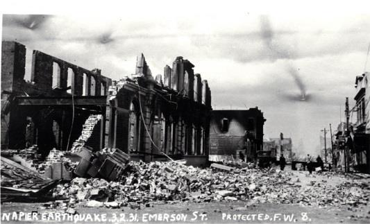


5 Significant historic earthquakes West Wairarapa 1855 Napier 1931 Edgecumbe 1987 Murchison 1929 Inangahua 1968 Christchurch 2011


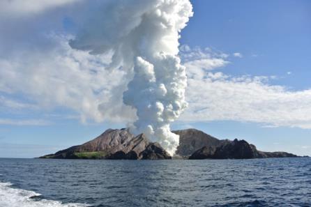


6 Significant volcanic events White Island Mt Tarawera 1886 Mt Ruapehu Mt Ngauruhoe


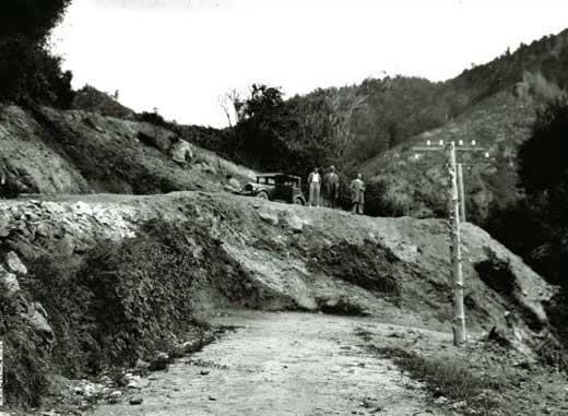
7 Early triangulation surveys Commenced in the 1880s 1st order control completed 1940s for NZGD49 Provided a foundation for measuring crustal deformation
8 Limitations with NZGD49 Regional distortions up to 5m present Built up in a piecemeal fashion Incompatible with global systems It is of limited spatial coverage It is static

9 Introduction of NZGD NZ introduced NZGD2000 (ref epoch 1 Jan 2000) geocentric origin aligned with the ITRS ITRF96 with epoch coordinates NZGD semi-dynamic datum - generalised motion of points modelled using a deformation model

10 Introduction of NZGD2000 Semi-dynamic datum current deformation model has horizontal constant velocities only initially generated using repeat surveys between 1992 and 1998 enables propagation of coordinates and observations between reference epoch and observation epoch for many uses has the appearance of a static datum

11 Measuring deformation - strain

12 Connecting to the datum 100,000+ control marks FIG Working Week 2012: TS 05C GNSS CORS Infrastructure and Applications I

13 Connecting to the datum PositioNZ Network 35 on the mainland of NZ 1 on the Chatham Islands 3 in Antarctica


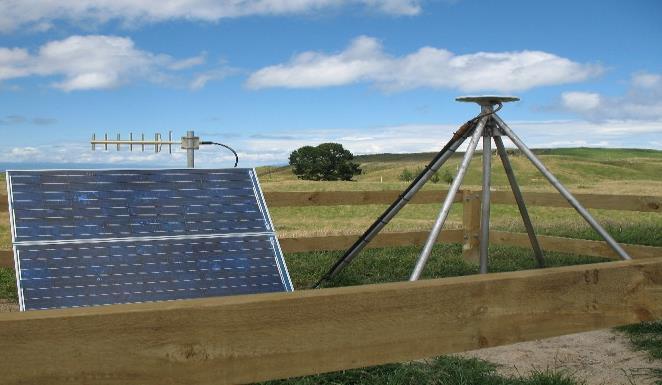
14 GEONET

15 Auckland - stable

16 Gisborne slow earthquakes

17 Christchurch Canterbury earthquakes
18 Fiordland postseismic recovery

19 Contribution to ITRF CORS VLBI DORIS

20 Contribution to Asia Pacific Reference Frame (APREF)
21 National deformation monitoring network National Deformation Monitoring Network (NDMN), - campaign stations measured every 8 years.
22 Enhancing the Deformation Model Horizontal model only Continuously updated and refining

23 Adding patches


24 Beavan, R.J.; Litchfield, N.J Vertical land movement around the New Zealand coastline: implications for sea-level rise, GNS Science Report 2012/29
25 Where are we at What has gone well Good user acceptance The incorporation of a deformation model in NZGD2000 has enabled the life of the datum to be lengthened and new observations to be integrated with old observations Accuracy of datum has been maintained Issues Managing the deformation model Accuracy of deformation model versus CORS real time positions Managing the spatial alignment of the cadastral system Misalignment of readjusted historic geodetic control with new surveyed geodetic control FIG/IAG/UNOOSA Technical Seminar Rome 4-5 May 2012
 Mean Sea Level Datum B Instantaneous Sea Level Datum C Geoid")
26 Vertical datums - Traditional levelling based datums 13 levelling based datums Each connected to a tide separate tide gauge based on MSL Not nationally consistent No national geoid Need local transformations Tidal Effect Sea Surface Topography Datum B Datum C Mean Sea Level Datum A Equipotential Surface (Geoid) Mean Sea Level Datum B Instantaneous Sea Level Datum C Geoid Datum A

27 New Zealand Vertical Datum 2009 First national vertical datum Based on NZGeoid cm nominal accuracy 3-15 cm local accuracy Need better than 3 cm in developed areas Includes official offsets to 13 main local vertical datums Datum Offset Std Dev One Tree Point Auckland Moturiki Gisborne Napier Taranaki Wellington Nelson Lyttelton Dunedin Dunedin-Bluff Bluff Stewart Island

28 Accuracy Improvement NZGeoid2009 based on existing gravity data Irregular and biased locations Gap in near-shore areas Airborne gravity best solution

29 New Zealand Vertical Datum 2016 To be published in June 2016 Based on NZGeoid cm nominal accuracy Transformation surfaces to local datums


30 Neap Range Spring Range Spring Rise Neap Rise FIG/IAG/UN-GGIM- AP/UN-ICG/NZIS Technical Seminar New Zealand Integrated Vertical Datum 2018? Abbreviation Term Connecting physical datum to geometric datum and providing transformations Seamless mapping of the land and sea HAT MHWS MHW MHWN MSL MLWN MLWS CD Charted Depth Sea Bed Highest Astronomical Tide Mean High Water Springs Mean High Water Mean High Water Neaps Mean Sea Level Mean Low Water Neaps Mean Low Water Springs Chart Datum (approximate Lowest Astronomical Tide) 30


31 The future

32 Vision: Accurately Positioning New Zealand for the Future
33 Vision and Goals Vision Accurately positioning New Zealand for the future Ten Year Goals 1. Enable the efficient definition of three-dimensional property rights through an accessible geodetic system 2. Measure temporal changes to the shape of the Earth s surface, model the gravity field and incorporate the effects into our reference frames 3. Support the maintenance of global reference frames and the connection of New Zealand s geodetic framework to them 4. Provide tools and services that enable accurate and reliable real-time positioning whenever and wherever it is required 5. Provide strong leadership in the development and use of the positioning system in New Zealand and support its development in the South-West Pacific

34 10 years from now Positioning has become truly ubiquitous Our challenges are to: provide a system which is invisible to users manage the dynamics remove complexity maintain accuracy be truly global realise real time coordinates be leaders and not followers embrace new technologies decide to what extent we support the mass market


35 Questions? Name Position
Progress Towards Upgrading and. Integrating Vertical Datums in New
 Progress Towards Upgrading and Presented at the FIG Working Week 2017, Integrating Vertical Datums in New May 29 - June 2, 2017 in Helsinki, Finland Zealand Graeme Blick Chief Geodesist What we ll cover
Development of Geoid Based Vertical Datums, A New Zealand Perspective
 Technical Seminar Reference Frame in Practice, Development of Geoid Based Vertical Datums, A New Zealand Perspective Matt Amos Manager Positioning and Innovation Land Information New Zealand Sponsors:
Exploring NZVD2016. NZ s National Vertical Datum. Rachelle Winefield. Senior Geodesist Location Information
 Exploring NZVD2016 NZ s National Vertical Datum Rachelle Winefield Senior Geodesist Location Information Email: rwinefield@linz.govt.nz www.linz.govt.nz Hawkes Bay S+SNZ Meeting 3 October 2018 Overview
Joining New Zealand Land and Sea Vertical Datums (JLAS) Graeme Blick Group Manager Positioning and Resilience
 Graeme Blick Group Manager Positioning and Resilience") Presented at the FIG Congress 2018, May 6-11, 2018 in Istanbul, Turkey Joining New Zealand Land and Sea Vertical Datums (JLAS) Graeme Blick Group Manager Positioning and Resilience Mapping NZ 2025 What
Presented at the FIG Congress 2018, May 6-11, 2018 in Istanbul, Turkey Joining New Zealand Land and Sea Vertical Datums (JLAS) Graeme Blick Group Manager Positioning and Resilience Mapping NZ 2025 What
Definition and use of the New Zealand Vertical Datum Matt Amos Senior Advisor Geodesy
 Definition and use of the New Zealand Vertical Datum 2009 Matt Amos Senior Advisor Geodesy NZIS Continuing Professional Development Programme, November 2009 Overview Height Theory Heights in New Zealand
Standard for New Zealand Vertical Datum 2016 LINZS25009
 Standard for New Zealand Vertical Datum 2016 LINZS25009 Effective Date: 27 June 2016 Table of Contents TERMS ND DEFINITIONS... 3 FOREWORD... 5 INTRODUCTION... 5 PURPOSE OF STNDRD... 5 BRIEF HISTORY OF
A NEW GEOCENTRIC DATUM FOR NEW ZEALAND
 A NEW GEOCENTRIC DATUM FOR NEW ZEALAND Don Grant Graeme Blick Office of Surveyor-General Land Information New Zealand PO Box 5501 Wellington New Zealand Phone 04 4600100 Fax 04 4722244 dgrant@linz.govt.nz
Progress Towards the Seamless Combination of Bathymetric and Topographic Data in New Zealand
 Progress Towards the Seamless Combination of Bathymetric and Topographic Data in New Zealand Matt Amos Senior Technical Advisor National Geodetic Office Introduction Datasets usually defined in terms of
PageNET: In Support of the Surveying Community
 Philippine Active Geodetic Network : In Support of the Surveying Community ICG Experts Meeting: Global Navigation Satellite Systems Services Vienna International Center, Vienna, Austria December 14-18,
Aligning the New Zealand National Datum with the International Terrestrial Reference Frame in the Face of Tectonic Deformation
 Aligning the New Zealand National Datum with the International Terrestrial Reference Frame in the Face of Tectonic Deformation Chris CROOK, Dionne HANSEN, Paula GENTLE, New Zealand Key words: deformation,
GNSS CORS in the Pacific
 GNSS CORS in the Pacific FIG References Frame in Practice Seminar Operational Aspects of GNSS CORS Technical Workshop Holiday Inn, Suva - Fiji PGSC Partnership Desk, GEM Division, Pacific Community (SPC)
Developing a National Real-time CORS Network in New Zealand
 Dave COLLETT, New Zealand Key words: GNSS, Positioning, CORS, New Zealand, Infrastructure SUMMARY Land Information New Zealand administers PositioNZ - New Zealand's national CORS network. This network
Geodetic Reference Frame Theory
 Technical Seminar Reference Frame in Practice, Geodetic Reference Frame Theory and the practical benefits of data sharing Geoffrey Blewitt University of Nevada, Reno, USA http://geodesy.unr.edu Sponsors:
Future of Reference Frames from Static to Dynamic? Markku Poutanen and Pasi Häkli
 Future of Reference Frames from Static to Dynamic? Markku Poutanen and Pasi Häkli Finnish Geospatial Research Institute, FGI Future of Reference Frames from Static to Dynamic? kinematic Markku Poutanen
Standard for the Australian Survey Control Network
 Standard for the Australian Survey Control Network Special Publication 1 Intergovernmental Committee on Survey and Mapping (ICSM) Geodesy Technical Sub-Committee (GTSC) 30 March 2012 Table of contents
Philippine Geodetic Infrastructure Status, Challenges and Future Direction
 Philippine Geodetic Infrastructure Status, Challenges and Future Direction Engr. Charisma Victoria D. Cayapan National Mapping and Resource Information Authority PHILIPPINES Outline Evolution of Geodetic
Overview of New Datums NOAA s National Geodetic Survey
 Overview of New Datums NOAA s National Geodetic Survey February 3, 2015 1 NGS s Mission and Role NGS Mission: To define, maintain, and provide access to the National Spatial Reference System to meet our
Determining Accurate Elevations: Datums & Tools, Today & Tomorrow
 Determining Accurate Elevations: Datums & Tools, Today & Tomorrow Association of State Floodplain Managers Annual Meeting Grand Rapids, MI Christine Gallagher June 21, 2016 Overview NGS Mission Important
An NGS Illustrated Guide to Geodesy for GIS Professionals
 An NGS Illustrated Guide to Geodesy for GIS Professionals Michael Dennis, RLS, PE michael.dennis@noaa.gov Esri User Conference San Diego Convention Center July 14-18, 2014 San Diego, CA Why should we care
The realization of a 3D Reference System
 The realization of a 3D Reference System Standard techniques: topographic surveying and GNSS Observe angles and distances either between points on the Earth surface or to satellites and stars. Do not observe
IAG School on Reference Systems June 7 June 12, 2010 Aegean University, Department of Geography Mytilene, Lesvos Island, Greece SCHOOL PROGRAM
 IAG School on Reference Systems June 7 June 12, 2010 Aegean University, Department of Geography Mytilene, Lesvos Island, Greece SCHOOL PROGRAM Monday June 7 8:00-9:00 Registration 9:00-10:00 Opening Session
Datum Transformations: Nightmare on GIS Street. Agenda
 Datum Transformations: Nightmare on GIS Street Speaker: Eric Gakstatter Contributing Editor GPS World Editor - Geospatial Solutions Presented at: Minnesota Society of Professional Surveyors Bloomington,
Session 1.2 Regional and National Reference Systems. Asia Pacific. Dr John Dawson Leader - National Geodesy Program Geoscience Australia
 Session 1.2 Regional and National Reference Systems Asia Pacific Dr John Dawson Leader - National Geodesy Program Geoscience Australia Presentation Overview Part 1 Australia s contributions to the ITRF
Overview of New Datums
 Overview of New Datums Scott Lokken NC Advisor NOAA s National Geodetic Survey 9/4/2015 1 New Datums are Coming in 2022! Both a new geometric and a new geopotential (vertical) datum will be released in
Choosing the best path:
 GEODESY Choosing the best path: Global to national coordinate transformations The paper demonstrates that differences of up to a few centimetres in each coordinate component can occur depending on the
Update on the International Terrestrial Reference Frame (ITRF)
") Update on the International Terrestrial Reference Frame (ITRF) Zuheir Altamimi Head of the IERS ITRF Product Center Institut National de l Information Géographique et Forestière IGN, France E-mail: zuheir.altamimi@ign.fr
Update on the International Terrestrial Reference Frame (ITRF) Zuheir Altamimi Head of the IERS ITRF Product Center Institut National de l Information Géographique et Forestière IGN, France E-mail: zuheir.altamimi@ign.fr
GPS Geodetic Reference System WGS 84
 GPS Geodetic Reference System WGS 84 International Committee on GNSS Working Group D Saint Petersburg, Russia 16 September 2009 Barbara Wiley National Geospatial-Intelligence Agency United States of America
Salient Feature of ITRF. Realization of Dubai Emirate Datum. Reference Frame 2000 (Ditr 2000)
") Salient Feature of ITRF on the Reference Frame 2000 (Ditr 2000) ITRF stands for International Terrestrial Reference Frame ITRF established by the International Earth Rotation Service (IERS), France. One
Salient Feature of ITRF on the Reference Frame 2000 (Ditr 2000) ITRF stands for International Terrestrial Reference Frame ITRF established by the International Earth Rotation Service (IERS), France. One
Determining Accurate Elevations: Datums & Tools, Today & Tomorrow
 Determining Accurate Elevations: Datums & Tools, Today & Tomorrow Maryland Association Floodplain and Stormwater Managers Linthicum Heights, MD Christine Gallagher Oct. 20, 2016 Overview NGS Mission Important
NATIONAL VDATUM -- THE IMPLEMENTATION OF A NATIONAL VERTICAL DATUM TRANSFORMATION DATABASE
 NATIONAL VDATUM -- THE IMPLEMENTATION OF A NATIONAL VERTICAL DATUM TRANSFORMATION DATABASE Bruce Parker, Dennis Milbert, Kurt Hess, and Stephen Gill National Ocean Service, NOAA The National Ocean Service
Datums for a Dynamic Earth
 Datums for a Dynamic Earth Based on a paper given at the American Society of Agricultural and Biological Engineers (ASABE) Conference in Reno, Nevada June 2009 Rollin StrohmanPh.D. Tom Mastin L.S Background
Who s heard of the GDA2020?
 Implications of a next generation datum in Australia on mining operations: A discussion. School of Civil & Environmental Engineering Craig Roberts Senior lecturer Surveying and Geospatial Engineering group
MONITORING SEA LEVEL USING GPS
 38 MONITORING SEA LEVEL USING GPS Hasanuddin Z. Abidin* Abstract GPS (Global Positioning System) is a passive, all-weather satellite-based navigation and positioning system, which is designed to provide
SIRGAS: BASIS FOR GEOSCIENCES, GEODATA, AND NAVIGATION IN LATIN AMERICA
 SIRGAS: BASIS FOR GEOSCIENCES, GEODATA, AND NAVIGATION IN LATIN AMERICA Laura Sánchez SIRGAS Vice-president Deutsches Geodätisches Forschungsintitut Munich, Germany Claudio Brunini SIRGAS President Universidad
Datums and Tools to Connect Geospatial Data Accurately
 Datums and Tools to Connect Geospatial Data Accurately Pamela Fromhertz Colorado State Geodetic Advisor National Geodetic Survey National Oceanic and Atmospheric Administration GIS-T April 18, 2012 Loveland,
Unification of height systems in the frame of GGOS
 Unification of height systems in the frame of GGOS Laura Sánchez Deutsches Geodätisches Forschungsinstitut der Technischen Universität München (DGFI-TUM) Centrum für Geodätische Erdsystemforschung (CGE)
What makes the positioning infrastructure work. Simon Kwok Chairman, Land Surveying Division Hong Kong Institute of Surveyors
 What makes the positioning infrastructure work The experience of the Hong Kong Satellite Positioning Reference Station Network Simon Kwok Chairman, Land Surveying Division Hong Kong Institute of Surveyors
GPS for crustal deformation studies. May 7, 2009
 GPS for crustal deformation studies May 7, 2009 High precision GPS for Geodesy Use precise orbit products (e.g., IGS or JPL) Use specialized modeling software GAMIT/GLOBK GIPSY OASIS BERNESE These software
Utilizing A GNSS Network Solution for Utility Applications
 Utilizing A GNSS Network Solution for Utility Applications David Newcomer, PE, PLS GPServ, Inc. newcomer@ (407) 601-5816 AGENDA Types and accuracies of data collection o Autonomous o Meter + o Sub-meter
Geodetic policy for Ireland and Northern Ireland
 Geodetic policy for Ireland and Northern Ireland Background Ordnance Survey Ireland (OSi) is the National Mapping Agency (NMA) of the Republic of Ireland. The Ordnance Survey of Northern Ireland (OSNI)
CHAPTER 2 GEODESY AND DATUMS IN NAVIGATION
 CHAPTER 2 GEODESY AND DATUMS IN NAVIGATION GEODESY, THE BASIS OF CARTOGRAPHY 200. Definition Geodesy is the application of mathematics to model the size and shape of the physical earth, enabling us to
Reference Frame in Practice Workshop 2A
 Reference Frame in Practice Workshop 2A A template for the development of a modernised geodetic infrastructure in Pacific Island states Richard Stanaway School of Civil and Environmental Engineering, University
BILL HENNING, Prof LS. ACRONYMS
 BILL HENNING, Prof LS. ACRONYMS US 1 WIKIPEDIA: Also known as geodetics, geodetic engineering or geodetics engineering a branch of applied mathematics [2] and earth sciences, is the scientific discipline
LSD PQSL Series Geodetic Survey. Prepared by Mr KWOK King-hung 22 May 2015
 LSD PQSL Series 2015 Geodetic Survey Prepared by Mr KWOK King-hung 22 May 2015 1 Geodesy Source from Wiki May 2015 also known as geodetics or geodetics engineering a branch of applied mathematics and earth
BATHYMETRIC DATA AND NAUTICAL CHART DATUMS
 Distr. LIMITED ECA/NRD/CART.9/USA.2 October 1996 Original: ENGLISH Ninth United Nations Regional Cartographic Conference for Africa Addis Ababa, Ethiopia 11-15 November 1996 A GLOBAL APPROACH TO UPDATE
Geodesy, Geographic Datums & Coordinate Systems
 Geodesy, Geographic Datums & Coordinate Systems What is the shape of the earth? Why is it relevant for GIS? 1/23/2018 2-1 From Conceptual to Pragmatic Dividing a sphere into a stack of pancakes (latitude)
Introduction to Datums James R. Clynch February 2006
 Introduction to Datums James R. Clynch February 2006 I. What Are Datums in Geodesy and Mapping? A datum is the traditional answer to the practical problem of making an accurate map. If you do not have
Application of GPS heights to Bay of Fundy multibeam data
 GEOLOGICAL SURVEY OF CANADA OPEN FILE 6658 Application of GPS heights to Bay of Fundy multibeam data David W. Dodd 2010 GEOLOGICAL SURVEY OF CANADA OPEN FILE 6658 Application of GPS heights to Bay of Fundy
GNSS & Coordinate Systems
 GNSS & Coordinate Systems Matthew McAdam, Marcelo Santos University of New Brunswick, Department of Geodesy and Geomatics Engineering, Fredericton, NB May 29, 2012 Santos, 2004 msantos@unb.ca 1 GNSS GNSS
Overview of Recent Tidal Projects in the United States
 1 st Tides and Water Levels Working Group Meeting Overview of Recent Tidal Projects in the United States Stephen Gill National Oceanic and Atmospheric Administration, National Ocean Service Center for
Status and plans for reference networks and systems in Denmark The Geodetic Infrastructure in Europe Umeå - Sweden, June 22-23, 2011
 Status and plans for reference networks and systems in Denmark The Geodetic Infrastructure in Europe Umeå - Sweden, June 22-23, 2011 Mette Weber and Lola Bahl National Survey and Cadastre - Denmark Content
Overview of Tides and Water Levels
 Overview of Tides and Water Levels www.tidesandcurrents.noaa.gov New Orleans, Baton Rouge, Lafayette, LA March 2009 Gerald Hovis, NOAA - National Ocean Service William Sweet, NOAA - National Ocean Service
INTEGRATING BATHYMETRY, TOPOGRAPHY, AND SHORELINE, AND THE IMPORTANCE OF VERTICAL DATUMS
 INTEGRATING BATHYMETRY, TOPOGRAPHY, AND SHORELINE, AND THE IMPORTANCE OF VERTICAL DATUMS Bruce Parker, Dennis Milbert, Kurt Hess, and Stephen Gill National Ocean Service, NOAA 1315 East-West Highway Silver
VERTICAL DATUM TRANSFORMATIONS FOR KINEMATIC GPS HYDROGRAPHIC SURVEYS. Kurt W. Hess, Dennis G. Milbert, Stephen K. Gill, and Daniel R.
 VERTICAL DATUM TRANSFORMATIONS FOR KINEMATIC GPS HYDROGRAPHIC SURVEYS Kurt W. Hess, Dennis G. Milbert, Stephen K. Gill, and Daniel R. Roman National Ocean Service, NOAA ABSTRACT Kinematic Global Positioning
Lecture # 7 Coordinate systems and georeferencing
 Lecture # 7 Coordinate systems and georeferencing Coordinate Systems Coordinate reference on a plane Coordinate reference on a sphere Coordinate reference on a plane Coordinates are a convenient way of
A Permanent GPS Array in Crete & the Cal/Val facility for satellite radar altimeters in Gavdos
 A Permanent GPS Array in Crete & the Cal/Val facility for satellite radar altimeters in Gavdos S. P. Mertikas Technical University f Crete EUREF 2007 Symposium, 6-96 9 June 2007, London, England Laboratory
CROPOS as Support of Geodetic Infrastructure in Croatia
 CROPOS as Support of Geodetic Infrastructure in Croatia Dr. Sc. Danko Markovinović - Croatia CLGE VicePresident The Geodetic Infrastructure in Europe - today and tomorrow Sweden...Umeå...22-23 June 2011
The Promise and Challenges of Accurate Low Latency GNSS for Environmental Monitoring and Response
 Technical Seminar Reference Frame in Practice, The Promise and Challenges of Accurate Low Latency GNSS for Environmental Monitoring and Response John LaBrecque Geohazards Focus Area Global Geodetic Observing
FieldGenius Technical Notes GPS Terminology
 FieldGenius Technical Notes GPS Terminology Almanac A set of Keplerian orbital parameters which allow the satellite positions to be predicted into the future. Ambiguity An integer value of the number of
CHAPTER 3. BASIC GEODESY
 CHAPTER 3. BASIC GEODESY SECTION I. THE GEODETIC SYSTEM A geodetic system serves as a framework for determining coordinates on the Earth s surface with respect to a reference ellipsoid and the geoid. It
Apport du VLBI à l ITRF: forces et faiblesses
 Apport du VLBI à l ITRF: forces et faiblesses Zuheir Altamimi Paul Rebischung Laurent Métivier Xavier Collilieux IGN, France Email: zuheir.altamimi@ign.fr Présenté par David Coulot Introduction: Points-clé
Understanding the Evolution of WGS 84 and NAD 83
 Summary Both WGS 84, the datum used by GPS,, commonly used in North America, have been redefined several times since their beginning. Parallel to this, there have also been several realizations of the
ELEMENTS OF THE NATIONAL SPATIAL REFERENCE SYSTEM
 Dave Doyle NGS Chief Geodetic Surveyor dave.doyle@noaa.gov 301-713-3178 ELEMENTS OF THE NATIONAL SPATIAL REFERENCE SYSTEM ESRI SURVEY SUMMIT San Diego, CA June 17, 2007 ftp://ftp.ngs.noaa.gov/dist/daved/esri
Coordinates, Datums, and Map Projection
 Coordinates, Datums, and Map Projection Two views on the World Intersect at 90 o angles Latitude/ Longitude is a Spherical System Acceptable latitudes/longitudes i) W125 o 27 33 ii) N92 o 45 12 iii)
21st International Conference of The Coastal Society
 21st International Conference of The Coastal Society DEVELOPMENT OF A VERTICAL DATUM TRANSFORMATION TOOL AND A BATHYMETRIC/TOPOGRAPHIC DIGITAL ELEVATION MODEL FOR SOUTHERN CALIFORNIA Edward P. Myers, NOAA/NOS
Precise Instantaneous Network Positioning
 Precise Instantaneous Network Positioning Direct and Inverse Network RTK Approaches Yehuda Bock, Jeff Fayman, David Honcik, Paul de Jonge, Lydia Bock Geodetics, Inc. La Jolla, California ION GNSS 2005
CGG. Office of the Surveyor General of the Federation Federal Capital Territory, Abuja, Nigeria 2
 Prof. P. C. Nwilo 1, * Dr. J. D. Dodo 2, U. R. Edozie 1, and A. Adebomehin 1. 1 Office of the Surveyor General of the Federation Federal Capital Territory, Abuja, Nigeria 2 Centre for Geodesy and Geodynamics,
ChartDatumWG Report to the BSHC 15 th Conference
 15 th BSHC Conference Agenda Item F1 21-23 September 2010 Explanatory Note Gdynia, Poland FINLAND BSHC Chart Datum Working Group ChartDatumWG Report to the BSHC 15 th Conference [10 September 2010] 1.
Connecting a Cadastral Survey to PNG94 using GNSS
 43rd Association of Surveyors PNG Congress, Lae, 12th-15th August 2009 Connecting a Cadastral Survey to PNG94 using GNSS Richard Stanaway QUICKCLOSE Workshop overview Legal requirements to connect surveys
Terrestrial Reference Frame of Serbia and its temporal rate
 Belgrade University Faculty of Civil Engineering Terrestrial Reference Frame of Serbia and its temporal rate Sofija Naod, Sanja Grekulović, Violeta Vasilić Oleg Odalović, Dragan Blagojević Department of
GEONET -CORS Network of japan-
 GEONET -CORS Network of japan- Basara Miyahara Geospatial Information Authority of Japan Geospatial and GNSS CORS Infrastructure Forum Kuala Lumpur - Malaysia Geospatial Information Authority of Japan
When not communicating with other stations, all VHF radios should be switched on and set to channel 16.
 USING THE MARITIME RADIO SERVICE Instructions The details of correct radio procedure are contained in a publication by Maritime New Zealand called Radio Handbook for Coastal Vessels. This should be consulted
BILL HENNING, Prof LS.
 BILL HENNING, Prof LS. DEFINITIONS: GEODESY, DATUMS, NSRS ACCESSING THE DATUM REALIZATION: PASSIVE MARKS, ACTIVE STATIONS WORLD SCIENTIFIC DATUMS HORIZONTAL, GEOMETRIC, VERTICAL, GRAVIMETRIC DATUMS IN
GSI Research and Development Basic Plan
 15 Abstract Aiming to define the basic direction for research and development (R&D) to be performed by the Geospatial Information Authority of Japan (GSI), this plan clarifies what kind of R&D should be
SURVEYORS BOARD OF QUEENSLAND. RTK GNSS for Cadastral Surveys. Guideline
 SURVEYORS BOARD OF QUEENSLAND RTK GNSS for Cadastral Surveys Guideline 30 November 2012 RTK GNSS for Cadastral Surveys General The Surveyors Board of Queensland has recently become aware of some issues
Connecting a Survey to PNG94 and MSL using GNSS
 45th Association of Surveyors PNG Congress, Madang, 19-22 July 2011 Connecting a Survey to PNG94 and MSL using GNSS Richard Stanaway QUICKCLOSE Workshop overview Legal requirements to connect surveys to
DGFI reference frame solution as contribution to ITRF2008
 COST Action: ES0701, Vienna, Austria, November 16-17, 2010 WG2: Velocity determination / reference frame realization DGFI reference frame solution as contribution to ITRF2008 D. Angermann, M. Seitz, H.
Korean Geodetic Datum 2002(KGD2002): Nationwide GPS Network Densification
: Nationwide GPS Network Densification") Korean Geodetic Datum 2002(KGD2002): Nationwide GPS Network Densification Young-Jin LEE, Hung-Kyu LEE, Kwang-Ho JEONG, and Sang-Hun CHA, Republic of Korea Key words: KGD2002, GPS, Network Densification,
Korean Geodetic Datum 2002(KGD2002): Nationwide GPS Network Densification Young-Jin LEE, Hung-Kyu LEE, Kwang-Ho JEONG, and Sang-Hun CHA, Republic of Korea Key words: KGD2002, GPS, Network Densification,
National report of Ukraine
 National report of Ukraine O. Kucher (1), A. Marchenko (3), O. Renkevich (1), S. Savchuk (3), I. Zaiats (2) 1) Research Institute of Geodesy and Cartography, Kyiv, Ukraine 2) State Service of Geodesy,
GNSS buoy array in the ocean for natural hazard mitigation. Teruyuki KATO Earthquake Research Institute the University of Tokyo, Japan
 GNSS buoy array in the ocean for natural hazard mitigation Teruyuki KATO Earthquake Research Institute the University of Tokyo, Japan 1 GNSS applications in Earth science From static to high-rate observations
Precise Positioning GNSS Applications
 Precise Point Positioning: Is the Era of Differential GNSS Positioning Drawing to an End? School of Surveying & Spatial Information Systems, UNSW, Sydney, Australia Chris Rizos 1, Volker Janssen 2, Craig
SNAP Tutorial. 1 November linz.govt.nz
 1 November 2017 linz.govt.nz Contents Introduction... 3 Target audience... 3 SNAP version... 3 Download and install SNAP... 3 Perl and connection to Geodetic Database... 3 Files required... 3 SNAP help...
Water Level Measurement and Tidal Datum Transfer Using High Rate GPS Buoys
 Water Level Measurement and Tidal Datum Transfer Using High Rate GPS Buoys Andrew MARSHALL and Paul DENYS, New Zealand Key words: GPS Buoy, Tidal Datum Transfer, Cadastral Boundaries, MHWS, Sea Level SUMMARY
Appendix A Lower Columbia River Chart Datum Modeling
 Appendix A Lower Columbia River Chart Datum Modeling David Evans and Associates, Inc. David Evans and Associates, Inc. 2801 SE Columbia Way, Ste. 130 Vancouver, WA 98661 (360) 314-3200 1.0 Vertical Datum
Basic Geodetics. Bobby Saleh Guidon Energy April 13, 2017
 Experts in Geomatics, Surveying, Positioning, Geospatial Data, and Mapping Sciences Basic Geodetics Bobby Saleh Guidon Energy b.saleh@guidonenergy.com April 13, 2017 The Earth is NOT flat Q: So what does
Specifications for Post-Earthquake Precise Levelling and GNSS Survey. Version 1.0 National Geodetic Office
 Specifications for Post-Earthquake Precise Levelling and GNSS Survey Version 1.0 National Geodetic Office 24 November 2010 Specification for Post-Earthquake Precise Levelling and GNSS Survey Page 1 of
SOME OBSERVATIONS ON THE USE OF GPS AND CHARTS
 International Hydrographic Review, Monaco, LXX(2), September 1993 SOME OBSERVATIONS ON THE USE OF GPS AND CHARTS by D. SIMPSON 1 INTRODUCTION The purpose of this paper is to bring to the attention of chart
3. GENERAL TIDAL DATUM COMPUTATION PROCEDURES
 3. GENERAL TIDAL DATUM COMPUTATION PROCEDURES 3.1 Datum Computation Procedures Overview A vertical datum is termed a tidal datum when it is defined by a certain phase of the tide. Tidal datums are local
Applications, Products and Services of GPS Technology
 Applications, Products and Services of GPS Technology Enrico C. Paringit. Dr. Eng. University of the Philippines Training Center for Applied Geodesy and Photogrammetry 1 Outline of this Presentation GPS
GPS for. Land Surveyors. Jan Van Sickle. Fourth Edition. CRC Press. Taylor & Francis Group. Taylor & Francis Croup, an Informa business
 GPS for Land Surveyors Fourth Edition Jan Van Sickle CRC Press Taylor & Francis Group Boca Raton London New York CRC Press is an imprint of the Taylor & Francis Croup, an Informa business Contents Preface
Computing Mean Sea Level Changes in Ghana
 Rui M.S. FERNANDES, Portugal, Yaw POKU-GYAMFI and Francis YEBOAH, Ghana, João P.F. FERREIRA, Portugal, Stephen DJABA and Emmanuel NKEBI, Ghana Key words: Coastal Zone Management, Deformation measurement,
Kobe, Japan July 2017 BULA WELCOME. Page 1
 BULA WELCOME Page 1 Technical Seminar Reference Frame in Practice, FIG/IAG/UN-GGIM-AP/ICG/GSI/JFS FIJI GEODETIC NETWORK Asakaia Tabuabisataki Principal Surveyor Ministry of Lands and Mineral Resources
National Reference Systems of the RUSSIAN FEDERATION, used in GLONASS. including the user and fundamental segments
 National Reference Systems of the RUSSIAN FEDERATION, used in GLONASS. including the user and fundamental segments 8-th Meeting of the International Committee on Global Navigation Satellite Systems Dubai,
WHAT DOES FIG SURVEYORS EXPECT IN COLLABORATIVE PARTNERSHIP WITH IGS
 WHAT DOES FIG SURVEYORS EXPECT IN COLLABORATIVE PARTNERSHIP WITH IGS Larry D. Hothem, Past Chair, FIG Commission 5, Positioning and Measurement U.S. Geological Survey, Reston, Virginia, USA (Lhothem@usgs.gov)
ITRF 2008 Realization of the Nigerian Geocentric Datum (GDN2012): Preliminary Results
: Preliminary Results") Journal of Emerging Trends in Engineering and Applied Sciences (JETEAS) 2 (6): 978-986 Scholarlink Research Institute Journals, 2011 (ISSN: 2141-7016) jeteas.scholarlinkresearch.org Journal of Emerging
Journal of Emerging Trends in Engineering and Applied Sciences (JETEAS) 2 (6): 978-986 Scholarlink Research Institute Journals, 2011 (ISSN: 2141-7016) jeteas.scholarlinkresearch.org Journal of Emerging
ITRF2014: Etat d'avancement et résultats préliminaires Zuheir Altamimi, Paul Rebischung, Xavier Collilieux, Laurent Métivier
 ITRF2014: Etat d'avancement et résultats préliminaires Zuheir Altamimi, Paul Rebischung, Xavier Collilieux, Laurent Métivier E-mail: zuheir.altamimi@ign.fr Key Points of ITRF2014 The Network: DORIS, GNSS,
Determination of GDA94 coordinates for station PDM1 at BMA s Peak Downs Mine in central Queensland using the June 2013 GPS data set
 Record 2013/42 GeoCat 76764 Determination of GDA94 coordinates for station PDM1 at BMA s Peak Downs Mine in central Queensland using the G. Hu, J. Dawson APPLYING GEOSCIENCE TO AUSTRALIA S MOST IMPORTANT
NATIONAL REPORT OF SLOVENIA
 Paper presented at the 18th EUREF Symposium held in Brussels, Belgium, 18 21 June 2008 NATIONAL REPORT OF SLOVENIA B. STOPAR1, B. KOLER1, M. KUHAR1, S. BERK2, D. RADOVAN2 1 Introduction This paper is the
Seamless Digital Data and Vertical Datums
 Seamless Digital Data and Vertical Datums Ruth ADAMS, United Kingdom Key words: seamless data, vertical datums, Chart Datum, digital data, UKHO. SUMMARY The creation of accurate seamless digital data requires
Datum Transformations in PNG EPSG Updates
 Datum Transformations in PNG EPSG Updates Richard Stanaway Quickclose Pty Ltd Overview of Geodetic datums used in PNG AGD66 Australian Geodetic Datum 1966 Used from 1960s (1:100,000 topographic mapping