Exploring NZVD2016. NZ s National Vertical Datum. Rachelle Winefield. Senior Geodesist Location Information
|
|
|
- Christopher Paul
- 5 years ago
- Views:
Transcription
1 Exploring NZVD2016 NZ s National Vertical Datum Rachelle Winefield Senior Geodesist Location Information rwinefield@linz.govt.nz Hawkes Bay S+SNZ Meeting 3 October 2018


2 Overview 1. If it s not broke why fix it? 2. Napier 1962 is not MSL 3. What a is geoid? 4. The difference between NZVD2009 and The magic of NZVD2016 orders 6. How good are the relationship grids? 7. Why must NZVD2016 heights change? 8. Maintenance, resurvey and the future Not covering : height theory, or gravity data collection


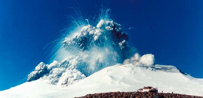
3 If its not broke Image courtesy ZNO

4 If its not broke Desirable attributes of a national vertical datum: Accessible - anywhere Consistent reference system Compatible with technologies GNSS heighting Precise levelling Fit for purpose Robust Maintainable and assessable Map of New Zealand Maritime boundaries. GNS Science (2013)

5 Local Vertical Datums

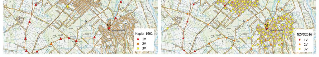
6 Napier 1962 is not MSL


7 Napier 1962 is not MSL Long, liner, poorly constrained networks Restricted to roads Accuracy assessed on an observation basis Errors propagate No relative assessment of marks not observed Benchmarks move Difficult to tell if a benchmark is disturbed Absolute accuracy is unknown

8 New Zealand Vertical Datum 2016 Well defined zero level NZGeoid2016 Nationally consistent Maintained heights Accuracy statistically assessed Improved density of marks Consistent with NZGD2000

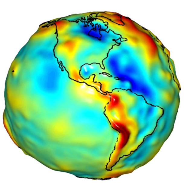
9 What is a geoid?

10 NZVD2009 vs NZVD2016

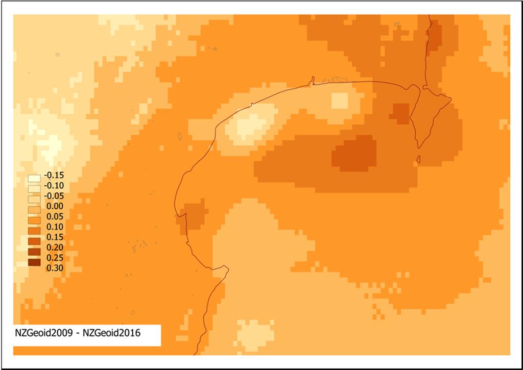
11 NZVD2009 vs NZVD2016
12 NZVD2016 transformations NZVD2016 heights (H) can be determined by subtracting a NZGeoid2016 height (N) from an ellipsoid/gnss height (h) H= h N The LVD Relationship Grids (OA) transform NZVD2016 heights (H) from LVD heights (HA) H A = H+O A

13 Case Study: Nelson City and Tasman District Tasman District and Nelson City Councils used to used independent height datums: Nelson 1955 and Nelson City Datum With a difference of ~12m. One building site within the Nelson City boundary, had services supplied via Tasman District Two sets of plans with two different heights had to be prepared. In July 2017, both councils successfully adopted NZVD2016 NZVD2016 is now the standard for


14 NZVD2016 Benefits Consistent heights Recoverable Readily accessible Easier to analyse multiple datasets Local Vertical Datums NZVD2016

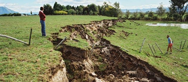
15 Living on a Dynamic Country - vertical deformation New Zealand is constantly moving Vertical deformation is not always obvious NZVD2016 heights move with the land Press Release:

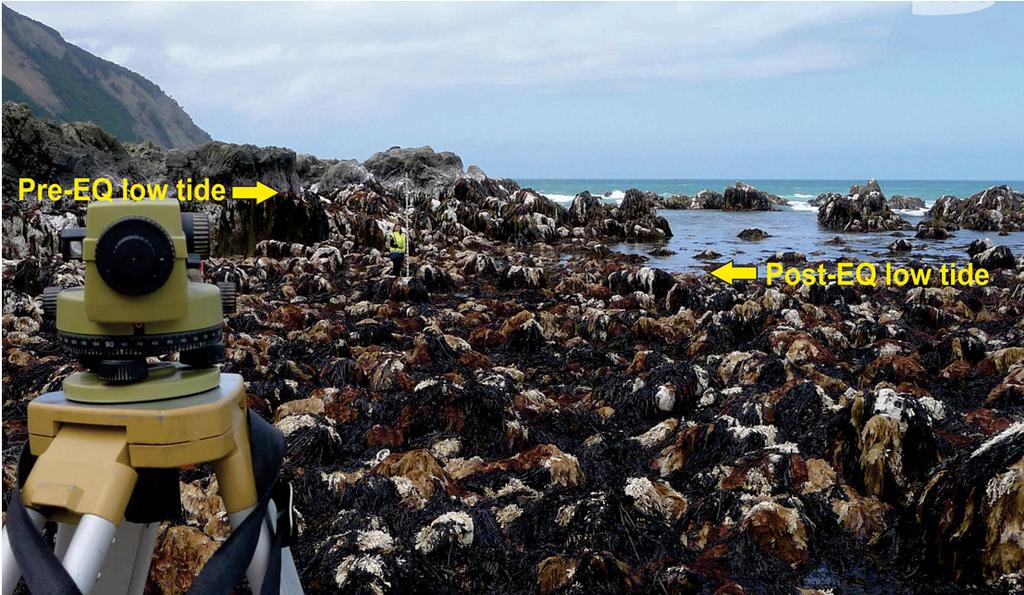
16 Resilience - Kaikōura Recovery The coastline lifted approximately 1.0 metre around Kaikōura, exposing kelp and paua.


17 Example Disaster recovery Current heights above the geoid can be observed using GNSS An accurate geoid would have reduced the need for extensive levelling Heights re-established by levelling 400 marks, 500 km NZGD2000 control re-established by GNSS Survey 250 marks

18 Local example:


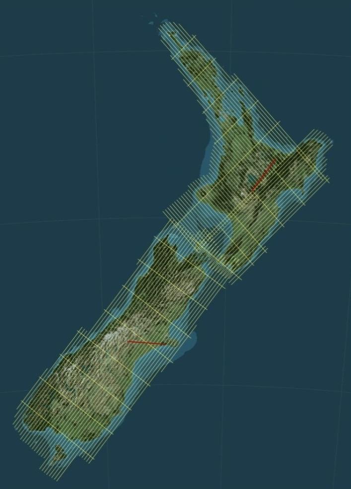
19 NZVD2016 Order Magic Determined by observation - GNSS - Terrestrial observations - Order 1-2V levelling Relatively consistent Tested against accuracy standards

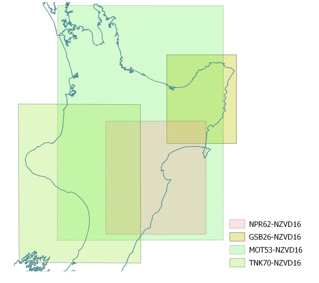
20 Relationship grids Datum Range STD Auckland Bluff Dunedin-Bluff Dunedin Gisborne Lyttelton Moturiki Napier Nelson One Tree Point Taranaki Wellington Stewart Island


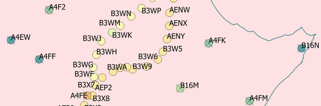
21 Relationship grid control marks Heighted Marks GPS/Levelling Control
 Point error: 1mm Distortion error: 0.5 ppm 0.23 0.")
22 Relationship grid example Created using: datumgrid Parameters Grid Spacing: 2 Zero height: LVD mean (0.20) Point error: 1mm Distortion error: 0.5 ppm Mean (m) Range (m) SD (m)
23

24 Geodetic Database


25 Living on a Dynamic Country New Zealand is constantly moving Vertical deformation is not always obvious Press Release: Victoria University of Wellington 23 November 2016

26 LINZ Tools
27 Geoid maintenance

28 Next Steps Datasets usually defined in terms of different vertical datums and reference surfaces Topography MSL Hydro LAT/CD Cadastral MHWS Geodesy MSL & ellipsoid Challenge is to combine different datasets Photo: 14/09/12 Stuff: Snells Beach
29 Maintenance of control points Regional Deformation Monitoring Networks 8 years Local Deformation Monitoring Networks Being established


30 NZ Vertical Datum 2009 MSL Based Datums New Zealand s vertical datums


31 Questions?
Progress Towards Upgrading and. Integrating Vertical Datums in New
 Progress Towards Upgrading and Presented at the FIG Working Week 2017, Integrating Vertical Datums in New May 29 - June 2, 2017 in Helsinki, Finland Zealand Graeme Blick Chief Geodesist What we ll cover
Development of Geoid Based Vertical Datums, A New Zealand Perspective
 Technical Seminar Reference Frame in Practice, Development of Geoid Based Vertical Datums, A New Zealand Perspective Matt Amos Manager Positioning and Innovation Land Information New Zealand Sponsors:
Definition and use of the New Zealand Vertical Datum Matt Amos Senior Advisor Geodesy
 Definition and use of the New Zealand Vertical Datum 2009 Matt Amos Senior Advisor Geodesy NZIS Continuing Professional Development Programme, November 2009 Overview Height Theory Heights in New Zealand
Standard for New Zealand Vertical Datum 2016 LINZS25009
 Standard for New Zealand Vertical Datum 2016 LINZS25009 Effective Date: 27 June 2016 Table of Contents TERMS ND DEFINITIONS... 3 FOREWORD... 5 INTRODUCTION... 5 PURPOSE OF STNDRD... 5 BRIEF HISTORY OF
Joining New Zealand Land and Sea Vertical Datums (JLAS) Graeme Blick Group Manager Positioning and Resilience
 Graeme Blick Group Manager Positioning and Resilience") Presented at the FIG Congress 2018, May 6-11, 2018 in Istanbul, Turkey Joining New Zealand Land and Sea Vertical Datums (JLAS) Graeme Blick Group Manager Positioning and Resilience Mapping NZ 2025 What
Presented at the FIG Congress 2018, May 6-11, 2018 in Istanbul, Turkey Joining New Zealand Land and Sea Vertical Datums (JLAS) Graeme Blick Group Manager Positioning and Resilience Mapping NZ 2025 What
New Zealand Reference Frame Case Study
 New Zealand Reference Frame Case Study Graeme Blick Chief Geodesist Land Information New Zealand 1 Fundamental role of the reference frame Requirements of a National Reference System A coordinate framework
Progress Towards the Seamless Combination of Bathymetric and Topographic Data in New Zealand
 Progress Towards the Seamless Combination of Bathymetric and Topographic Data in New Zealand Matt Amos Senior Technical Advisor National Geodetic Office Introduction Datasets usually defined in terms of
A NEW GEOCENTRIC DATUM FOR NEW ZEALAND
 A NEW GEOCENTRIC DATUM FOR NEW ZEALAND Don Grant Graeme Blick Office of Surveyor-General Land Information New Zealand PO Box 5501 Wellington New Zealand Phone 04 4600100 Fax 04 4722244 dgrant@linz.govt.nz
Specifications for Post-Earthquake Precise Levelling and GNSS Survey. Version 1.0 National Geodetic Office
 Specifications for Post-Earthquake Precise Levelling and GNSS Survey Version 1.0 National Geodetic Office 24 November 2010 Specification for Post-Earthquake Precise Levelling and GNSS Survey Page 1 of
Philippine Geodetic Infrastructure Status, Challenges and Future Direction
 Philippine Geodetic Infrastructure Status, Challenges and Future Direction Engr. Charisma Victoria D. Cayapan National Mapping and Resource Information Authority PHILIPPINES Outline Evolution of Geodetic
Standard for the Australian Survey Control Network
 Standard for the Australian Survey Control Network Special Publication 1 Intergovernmental Committee on Survey and Mapping (ICSM) Geodesy Technical Sub-Committee (GTSC) 30 March 2012 Table of contents
National report of Ukraine
 National report of Ukraine O. Kucher (1), A. Marchenko (3), O. Renkevich (1), S. Savchuk (3), I. Zaiats (2) 1) Research Institute of Geodesy and Cartography, Kyiv, Ukraine 2) State Service of Geodesy,
Establishing Cadastral Control using GNSS
 Establishing Cadastral Control using GNSS Richard Stanaway Quickclose Case study control for a typical rural residential subdivision Why use GNSS? no line of sight required centimetre precision connection
Developing a National Real-time CORS Network in New Zealand
 Dave COLLETT, New Zealand Key words: GNSS, Positioning, CORS, New Zealand, Infrastructure SUMMARY Land Information New Zealand administers PositioNZ - New Zealand's national CORS network. This network
Overview of New Datums NOAA s National Geodetic Survey
 Overview of New Datums NOAA s National Geodetic Survey February 3, 2015 1 NGS s Mission and Role NGS Mission: To define, maintain, and provide access to the National Spatial Reference System to meet our
SNAP Tutorial. 1 November linz.govt.nz
 1 November 2017 linz.govt.nz Contents Introduction... 3 Target audience... 3 SNAP version... 3 Download and install SNAP... 3 Perl and connection to Geodetic Database... 3 Files required... 3 SNAP help...
GNSS CORS in the Pacific
 GNSS CORS in the Pacific FIG References Frame in Practice Seminar Operational Aspects of GNSS CORS Technical Workshop Holiday Inn, Suva - Fiji PGSC Partnership Desk, GEM Division, Pacific Community (SPC)
SURVEYORS BOARD OF QUEENSLAND. RTK GNSS for Cadastral Surveys. Guideline
 SURVEYORS BOARD OF QUEENSLAND RTK GNSS for Cadastral Surveys Guideline 30 November 2012 RTK GNSS for Cadastral Surveys General The Surveyors Board of Queensland has recently become aware of some issues
NATIONAL REPORT OF SLOVENIA
 27th EUREF Symposium NATIONAL REPORT OF SLOVENIA Klemen Medved, Sandi Berk, Žarko Komadina, Jurij Režek (Surveying and Mapping Authority of the Republic of Slovenia, Ljubljana) Niko Fabiani, Katja Oven
OUR INDUSTRIAL LEGACY WHAT ARE WE LEAVING OUR CHILDREN REAAA Roadshow Taupo, August 2016 Young presenter s competition
 OUR INDUSTRIAL LEGACY WHAT ARE WE LEAVING OUR CHILDREN Preserving the country s aerial photography archive for future generations Abstract For over eighty years, aerial photography has captured the changing
Aligning the New Zealand National Datum with the International Terrestrial Reference Frame in the Face of Tectonic Deformation
 Aligning the New Zealand National Datum with the International Terrestrial Reference Frame in the Face of Tectonic Deformation Chris CROOK, Dionne HANSEN, Paula GENTLE, New Zealand Key words: deformation,
Choosing the best path:
 GEODESY Choosing the best path: Global to national coordinate transformations The paper demonstrates that differences of up to a few centimetres in each coordinate component can occur depending on the
The Global Positioning System II Field Experiments
 The Global Positioning System II Field Experiments 5-1 Mexico DGPS Field Campaign Cenotes in Tamaulipas, MX, near Aldama 5-2 Are Cenote Water Levels Related? 5-3 DGPS Static Survey of Cenote Water Levels
Utilizing A GNSS Network Solution for Utility Applications
 Utilizing A GNSS Network Solution for Utility Applications David Newcomer, PE, PLS GPServ, Inc. newcomer@ (407) 601-5816 AGENDA Types and accuracies of data collection o Autonomous o Meter + o Sub-meter
PROPOSED NATIONAL GEODETIC DATABASE (NGDB) Coordinates. Orthometric Height Source
 Coordinates. Orthometric Height Source") Stations Name1, Name2, Name3 Custodian Orthometric Height Height Identifier MSL/AHD height Vert Class, Vert order, Ht method Supersedes, superseded by (double linked list AHD/MSL datum COMMENTS Fieldbooks
Stations Name1, Name2, Name3 Custodian Orthometric Height Height Identifier MSL/AHD height Vert Class, Vert order, Ht method Supersedes, superseded by (double linked list AHD/MSL datum COMMENTS Fieldbooks
The Global Positioning Sytem II 10/19/2017
 The Global Positioning System II Field Experiments 10/19/2017 5-1 Mexico DGPS Field Campaign Cenotes in Tamaulipas, MX, near Aldama 10/19/2017 5-2 Are Cenote Water Levels Related? 10/19/2017 5-3 M. Helper,
Option 1. Design Options are diverse e.g. new route alignments covering a wide area. Option 2. Design Options are restricted
 MINIMUM STANDARD Z/16 SURVEY SPECIFICATIONS 1. GENERAL This specification sets out the Consultant s requirements for topographical survey (ground and aerial) for the Detailed Business Case (DBC) and Pre-Implementation
What makes the positioning infrastructure work. Simon Kwok Chairman, Land Surveying Division Hong Kong Institute of Surveyors
 What makes the positioning infrastructure work The experience of the Hong Kong Satellite Positioning Reference Station Network Simon Kwok Chairman, Land Surveying Division Hong Kong Institute of Surveyors
Introduction to Datums James R. Clynch February 2006
 Introduction to Datums James R. Clynch February 2006 I. What Are Datums in Geodesy and Mapping? A datum is the traditional answer to the practical problem of making an accurate map. If you do not have
Geodetic policy for Ireland and Northern Ireland
 Geodetic policy for Ireland and Northern Ireland Background Ordnance Survey Ireland (OSi) is the National Mapping Agency (NMA) of the Republic of Ireland. The Ordnance Survey of Northern Ireland (OSNI)
Determining Accurate Elevations: Datums & Tools, Today & Tomorrow
 Determining Accurate Elevations: Datums & Tools, Today & Tomorrow Association of State Floodplain Managers Annual Meeting Grand Rapids, MI Christine Gallagher June 21, 2016 Overview NGS Mission Important
Lecture # 7 Coordinate systems and georeferencing
 Lecture # 7 Coordinate systems and georeferencing Coordinate Systems Coordinate reference on a plane Coordinate reference on a sphere Coordinate reference on a plane Coordinates are a convenient way of
When not communicating with other stations, all VHF radios should be switched on and set to channel 16.
 USING THE MARITIME RADIO SERVICE Instructions The details of correct radio procedure are contained in a publication by Maritime New Zealand called Radio Handbook for Coastal Vessels. This should be consulted
Determining Accurate Elevations: Datums & Tools, Today & Tomorrow
 Determining Accurate Elevations: Datums & Tools, Today & Tomorrow Maryland Association Floodplain and Stormwater Managers Linthicum Heights, MD Christine Gallagher Oct. 20, 2016 Overview NGS Mission Important
APPLICATIONS OF KINEMATIC GPS AT SHOM
 International Hydrographic Review, Monaco, LXXVI(1), March 1999 APPLICATIONS OF KINEMATIC GPS AT SHOM by Michel EVEN 1 Abstract The GPS in kinematic mode has now been in use at SHOM for several years in
Water Level Measurement and Tidal Datum Transfer Using High Rate GPS Buoys
 Water Level Measurement and Tidal Datum Transfer Using High Rate GPS Buoys Andrew MARSHALL and Paul DENYS, New Zealand Key words: GPS Buoy, Tidal Datum Transfer, Cadastral Boundaries, MHWS, Sea Level SUMMARY
Overview of Tides and Water Levels
 Overview of Tides and Water Levels www.tidesandcurrents.noaa.gov New Orleans, Baton Rouge, Lafayette, LA March 2009 Gerald Hovis, NOAA - National Ocean Service William Sweet, NOAA - National Ocean Service
LSD PQSL Series Geodetic Survey. Prepared by Mr KWOK King-hung 22 May 2015
 LSD PQSL Series 2015 Geodetic Survey Prepared by Mr KWOK King-hung 22 May 2015 1 Geodesy Source from Wiki May 2015 also known as geodetics or geodetics engineering a branch of applied mathematics and earth
Geodesy, Geographic Datums & Coordinate Systems
 Geodesy, Geographic Datums & Coordinate Systems What is the shape of the earth? Why is it relevant for GIS? 1/23/2018 2-1 From Conceptual to Pragmatic Dividing a sphere into a stack of pancakes (latitude)
Unification of height systems in the frame of GGOS
 Unification of height systems in the frame of GGOS Laura Sánchez Deutsches Geodätisches Forschungsinstitut der Technischen Universität München (DGFI-TUM) Centrum für Geodätische Erdsystemforschung (CGE)
An NGS Illustrated Guide to Geodesy for GIS Professionals
 An NGS Illustrated Guide to Geodesy for GIS Professionals Michael Dennis, RLS, PE michael.dennis@noaa.gov Esri User Conference San Diego Convention Center July 14-18, 2014 San Diego, CA Why should we care
Harmonisation of the Vertical Reference Systems. of nautical charts around the Baltic Sea
 Harmonisation of the Vertical Reference Systems of nautical charts around the Baltic Sea (29 May 2007) Introduction The BSHC 11 th Conference decided that the current status of vertical reference systems
Beginners Guide to GPS Elevation Plus an Update on GPS Technology
 Beginners Guide to GPS Elevation Plus an Update on GPS Technology A TMS Presentation By: Jon Aschenbach Summerlake Enterprises 919 36 th Place Forest Grove, OR 97116 503-707-6236 Coeur d Alene, ID April,
Connecting a Cadastral Survey to PNG94 using GNSS
 43rd Association of Surveyors PNG Congress, Lae, 12th-15th August 2009 Connecting a Cadastral Survey to PNG94 using GNSS Richard Stanaway QUICKCLOSE Workshop overview Legal requirements to connect surveys
HEIGHTING WITH GPS: POSSIBILITIES AND LIMITATIONS
 HEIGHTING WITH GPS: POSSIBILITIES AND LIMITATIONS Matthew B. Higgins ABSTRACT Global Positioning System (GPS) surveying is now seen as a true three dimensional tool and GPS heighting can be a viable alternative
Who s heard of the GDA2020?
 Implications of a next generation datum in Australia on mining operations: A discussion. School of Civil & Environmental Engineering Craig Roberts Senior lecturer Surveying and Geospatial Engineering group
CGG. Office of the Surveyor General of the Federation Federal Capital Territory, Abuja, Nigeria 2
 Prof. P. C. Nwilo 1, * Dr. J. D. Dodo 2, U. R. Edozie 1, and A. Adebomehin 1. 1 Office of the Surveyor General of the Federation Federal Capital Territory, Abuja, Nigeria 2 Centre for Geodesy and Geodynamics,
land transport road assets
 ISSN 1177-6285 land transport road assets land transport road assets comparison of all territorial authorities Information as at June 2007 land transport road assets 2 Purpose of this publication Land
NATIONAL VDATUM -- THE IMPLEMENTATION OF A NATIONAL VERTICAL DATUM TRANSFORMATION DATABASE
 NATIONAL VDATUM -- THE IMPLEMENTATION OF A NATIONAL VERTICAL DATUM TRANSFORMATION DATABASE Bruce Parker, Dennis Milbert, Kurt Hess, and Stephen Gill National Ocean Service, NOAA The National Ocean Service
land transport road assets
 ISSN 1177-6285 land transport road assets land transport road assets comparison of all territorial authorities Information as at June 2006 land transport road assets 2 Purpose of this publication Land
The Global Positioning System II Field Experiments. 10/10/2013 GEO327G/386G, UT Austin 5-1
 The Global Positioning System II Field Experiments 10/10/2013 GEO327G/386G, UT Austin 5-1 Mexico DGPS Field Campaign Cenotes in Tamaulipas, MX, near Aldama 10/10/2013 GEO327G/386G, UT Austin 5-2 Are Cenote
Connecting a Survey to PNG94 and MSL using GNSS
 45th Association of Surveyors PNG Congress, Madang, 19-22 July 2011 Connecting a Survey to PNG94 and MSL using GNSS Richard Stanaway QUICKCLOSE Workshop overview Legal requirements to connect surveys to
GNSS & Coordinate Systems
 GNSS & Coordinate Systems Matthew McAdam, Marcelo Santos University of New Brunswick, Department of Geodesy and Geomatics Engineering, Fredericton, NB May 29, 2012 Santos, 2004 msantos@unb.ca 1 GNSS GNSS
Chapter 6 GPS Relative Positioning Determination Concepts
 Chapter 6 GPS Relative Positioning Determination Concepts 6-1. General Absolute positioning, as discussed earlier, will not provide the accuracies needed for most USACE control projects due to existing
INTEGRATING BATHYMETRY, TOPOGRAPHY, AND SHORELINE, AND THE IMPORTANCE OF VERTICAL DATUMS
 INTEGRATING BATHYMETRY, TOPOGRAPHY, AND SHORELINE, AND THE IMPORTANCE OF VERTICAL DATUMS Bruce Parker, Dennis Milbert, Kurt Hess, and Stephen Gill National Ocean Service, NOAA 1315 East-West Highway Silver
Precise Positioning with NovAtel CORRECT Including Performance Analysis
 Precise Positioning with NovAtel CORRECT Including Performance Analysis NovAtel White Paper April 2015 Overview This article provides an overview of the challenges and techniques of precise GNSS positioning.
SHORT NOTE. Distribution of New Zealand falcon (Falco novaeseelandiae): Results of a 10-year survey
: Results of a 10-year survey") 234 Notornis, 2017, Vol. 64: 234-238 0029-4470 The Ornithological Society of New Zealand Inc. SHORT NOTE Distribution of New Zealand falcon (Falco novaeseelandiae): Results of a 10-year survey 2006-2016
234 Notornis, 2017, Vol. 64: 234-238 0029-4470 The Ornithological Society of New Zealand Inc. SHORT NOTE Distribution of New Zealand falcon (Falco novaeseelandiae): Results of a 10-year survey 2006-2016
Control Position Fix Using Single Frequency Global Positioning System Receiver Technique - A Case Study
 Research Journal of Environmental and Earth Sciences 3(1): 32-37, 2011 ISSN: 2041-0492 Maxwell Scientific Organization, 2011 Received: September 10, 2010 Accepted: October 09, 2010 Published: January 05,
National Report of Finland
 National Report of Finland 1. Finnish Hydrographic Office The Finnish Hydrographic Office is organized under The Finnish Transport Agency. The Finnish Transport Agency is responsible for the Finnish roads,
GNSS 101 Bringing It Down To Earth
 GNSS 101 Bringing It Down To Earth Steve Richter Frontier Precision, Inc. UTM County Coordinates NGVD 29 State Plane Datums Scale Factors Projections Session Agenda GNSS History & Basic Theory Coordinate
FieldGenius Technical Notes GPS Terminology
 FieldGenius Technical Notes GPS Terminology Almanac A set of Keplerian orbital parameters which allow the satellite positions to be predicted into the future. Ambiguity An integer value of the number of
Appendix A Lower Columbia River Chart Datum Modeling
 Appendix A Lower Columbia River Chart Datum Modeling David Evans and Associates, Inc. David Evans and Associates, Inc. 2801 SE Columbia Way, Ste. 130 Vancouver, WA 98661 (360) 314-3200 1.0 Vertical Datum
Block Offer 2014 Awards Questions and Answers... 1
 Block Offer 2014 Awards Questions and Answers December, 2014 Contents Block Offer 2014 Awards Questions and Answers... 1 What is a Block Offer?... 2 When did Block Offer 2014 open?... 2 How are bids assessed?...
21st International Conference of The Coastal Society
 21st International Conference of The Coastal Society DEVELOPMENT OF A VERTICAL DATUM TRANSFORMATION TOOL AND A BATHYMETRIC/TOPOGRAPHIC DIGITAL ELEVATION MODEL FOR SOUTHERN CALIFORNIA Edward P. Myers, NOAA/NOS
Status and plans for reference networks and systems in Denmark The Geodetic Infrastructure in Europe Umeå - Sweden, June 22-23, 2011
 Status and plans for reference networks and systems in Denmark The Geodetic Infrastructure in Europe Umeå - Sweden, June 22-23, 2011 Mette Weber and Lola Bahl National Survey and Cadastre - Denmark Content
IAG School on Reference Systems June 7 June 12, 2010 Aegean University, Department of Geography Mytilene, Lesvos Island, Greece SCHOOL PROGRAM
 IAG School on Reference Systems June 7 June 12, 2010 Aegean University, Department of Geography Mytilene, Lesvos Island, Greece SCHOOL PROGRAM Monday June 7 8:00-9:00 Registration 9:00-10:00 Opening Session
3. GENERAL TIDAL DATUM COMPUTATION PROCEDURES
 3. GENERAL TIDAL DATUM COMPUTATION PROCEDURES 3.1 Datum Computation Procedures Overview A vertical datum is termed a tidal datum when it is defined by a certain phase of the tide. Tidal datums are local
From Passive to Active Control Point Networks Evaluation of Accuracy in Static GPS Surveying
 From Passive to Active Control Point Networks Evaluation of Accuracy in Static GPS Surveying P. Häkli 1, U. Kallio 1 and J. Puupponen 2 1) Finnish Geodetic Institute 2) National Land Survey of Finland
Datums and Tools to Connect Geospatial Data Accurately
 Datums and Tools to Connect Geospatial Data Accurately Pamela Fromhertz Colorado State Geodetic Advisor National Geodetic Survey National Oceanic and Atmospheric Administration GIS-T April 18, 2012 Loveland,
ELEMENTS OF THE NATIONAL SPATIAL REFERENCE SYSTEM
 Dave Doyle NGS Chief Geodetic Surveyor dave.doyle@noaa.gov 301-713-3178 ELEMENTS OF THE NATIONAL SPATIAL REFERENCE SYSTEM ESRI SURVEY SUMMIT San Diego, CA June 17, 2007 ftp://ftp.ngs.noaa.gov/dist/daved/esri
Datum Transformations: Nightmare on GIS Street. Agenda
 Datum Transformations: Nightmare on GIS Street Speaker: Eric Gakstatter Contributing Editor GPS World Editor - Geospatial Solutions Presented at: Minnesota Society of Professional Surveyors Bloomington,
Natural Disaster Hotspots Data
 Natural Disaster Hotspots Data Source: Dilley, M., R.S. Chen, U. Deichmann, A.L. Lerner-Lam, M. Arnold, J. Agwe, P. Buys, O. Kjekstad, B. Lyon, and G. Yetman. 2005. Natural Disaster Hotspots: A Global
PageNET: In Support of the Surveying Community
 Philippine Active Geodetic Network : In Support of the Surveying Community ICG Experts Meeting: Global Navigation Satellite Systems Services Vienna International Center, Vienna, Austria December 14-18,
R E P O R T. of the BSHC Working Group for the Harmonization of the Chart Datum of the Baltic Sea (CDWG)
") 12-14 June 2007 Explanatory Note Klaipeda, Lithuania R E P O R T of the BSHC Working Group for the Harmonization of the Chart Datum of the Baltic Sea (CDWG) Activities of the CDWG The CDWG was established
12-14 June 2007 Explanatory Note Klaipeda, Lithuania R E P O R T of the BSHC Working Group for the Harmonization of the Chart Datum of the Baltic Sea (CDWG) Activities of the CDWG The CDWG was established
Ian Church 1, Steven Brucker 1, Dr. John Hughes Clarke 1, Susan Haigh 1, Jason Bartlett 2 and Tim Janzen 2
 Developing Strategies to Facilitate using Post Processed GPS and Tidal Models Ian Church 1, Steven Brucker 1, Dr. John Hughes Clarke 1, Susan Haigh 1, Jason Bartlett 2 and Tim Janzen 2 1: Dept. Geodesy
DETERMINATION OF VERTICAL DATUM LEVEL FOR TIDAL BENCH MARK USING GNSS BUOY OBSERVATIONS
 Journal of Marine Science and Technology, Vol. 25, No. 6, pp. 689-695 (2017) 689 DOI: 10.6119/JMST-017-1226-09 DETERMINATION OF VERTICAL DATUM LEVEL FOR TIDAL BENCH MARK USING GNSS BUOY OBSERVATIONS Jae
CROPOS as Support of Geodetic Infrastructure in Croatia
 CROPOS as Support of Geodetic Infrastructure in Croatia Dr. Sc. Danko Markovinović - Croatia CLGE VicePresident The Geodetic Infrastructure in Europe - today and tomorrow Sweden...Umeå...22-23 June 2011
Kobe, Japan July 2017 BULA WELCOME. Page 1
 BULA WELCOME Page 1 Technical Seminar Reference Frame in Practice, FIG/IAG/UN-GGIM-AP/ICG/GSI/JFS FIJI GEODETIC NETWORK Asakaia Tabuabisataki Principal Surveyor Ministry of Lands and Mineral Resources
INTERDISCIPLINARY SCIENCE AND APPLICATIONS USING SATELLITE RADAR ALTIMETRY
 NASA NASA ESA ESA JAXA NAS A INTERDISCIPLINARY SCIENCE AND APPLICATIONS USING SATELLITE RADAR ALTIMETRY C.K. SHUM EE Wave Propagation and Remote Sensing Joel Johnson November 14, 2012 Measurement Coverage:
Genealogical Sources Guide. Residences. Prospector s Hut, Terrytown near Beaumont ca SO6-443a
 Genealogical Sources Guide Residences Prospector s Hut, Terrytown near Beaumont ca.1890. SO6-443a Hocken Collections/Te Uare Taoka o Hākena, University of Otago Library Nau Mai Haere Mai ki Te Uare Taoka
SURVEYING I CENG 383
 SURVEYING I CENG 383 9/21/2011 2 Introduction Definition An art of collecting data for mapping the relative positions of points above, below or on the surface of the earth. Surveying also includes the
BSHC23_C2_SE_CDWG Report
 BSHC23_C2_SE_CDWG Report Thomas Hammarklint Swedish Maritime Administration (SMA) Thomas.Hammarklint@sjofartsverket.se 28 August 2018 Objectives 1. Answer to BSHC22, Action #22 and a proposal for a new
Standardization of national shift grids for the transformation between national projected reference frames and ETRS89
 Standardization of national shift grids for the between national projected reference frames and Lennard Huisman Kadaster Netherlands EUREF 2014 June 3-7, Vilnius, Lithuania lennard.huisman@kadaster.nl
BATHYMETRIC DATA AND NAUTICAL CHART DATUMS
 Distr. LIMITED ECA/NRD/CART.9/USA.2 October 1996 Original: ENGLISH Ninth United Nations Regional Cartographic Conference for Africa Addis Ababa, Ethiopia 11-15 November 1996 A GLOBAL APPROACH TO UPDATE
The realization of a 3D Reference System
 The realization of a 3D Reference System Standard techniques: topographic surveying and GNSS Observe angles and distances either between points on the Earth surface or to satellites and stars. Do not observe
CHAPTER 2 GEODESY AND DATUMS IN NAVIGATION
 CHAPTER 2 GEODESY AND DATUMS IN NAVIGATION GEODESY, THE BASIS OF CARTOGRAPHY 200. Definition Geodesy is the application of mathematics to model the size and shape of the physical earth, enabling us to
9/26/2016. Accuracy with GNSS What are you getting? Presented By Tom Bryant PLS Kelly Harris PLS Seiler Instrument
 Accuracy with GNSS What are you getting? Presented By Tom Bryant PLS Kelly Harris PLS Seiler Instrument 1 What We Will Talk About Today What coordinate system should I use in my data collector Site Calibrations-what
APPENDIX K NAPIER PORT WHARF NO. 6 FUTURE PORT NOISE MAPS
 APPENDIX K NAPIER PORT WHARF NO. 6 FUTURE PORT NOISE MAPS PORT OF NAPIER WHARF 6 FUTURE PORT NOISE MAPS (2026) Rp 004 r02 2015784A 20 September 2016 84 Symonds Street PO Box 5811 Wellesley Street Auckland
MONITORING SEA LEVEL USING GPS
 38 MONITORING SEA LEVEL USING GPS Hasanuddin Z. Abidin* Abstract GPS (Global Positioning System) is a passive, all-weather satellite-based navigation and positioning system, which is designed to provide
Vertical Datum Conversions for Regional Coastal Management
 Vertical Datum Conversions for Regional Coastal Management Jennifer M. Wozencraft Joint Airborne Lidar Bathymetry Technical Center of Expertise US Army Engineer District Mobile 109 St. Joseph Street Mobile,
VERTICAL DATUM TRANSFORMATIONS FOR KINEMATIC GPS HYDROGRAPHIC SURVEYS. Kurt W. Hess, Dennis G. Milbert, Stephen K. Gill, and Daniel R.
 VERTICAL DATUM TRANSFORMATIONS FOR KINEMATIC GPS HYDROGRAPHIC SURVEYS Kurt W. Hess, Dennis G. Milbert, Stephen K. Gill, and Daniel R. Roman National Ocean Service, NOAA ABSTRACT Kinematic Global Positioning
3.5 GHz Allowing greater use of TDD. Decision Document 2 June 2015
 3.5 GHz Allowing greater use of Decision Document 2 June 2015 Contents Background... 3 Decisions... 3 Revised timeframe... 4 Rights expiry and review process... 4 Annex 1: List of TLAs and corresponding
Future of Reference Frames from Static to Dynamic? Markku Poutanen and Pasi Häkli
 Future of Reference Frames from Static to Dynamic? Markku Poutanen and Pasi Häkli Finnish Geospatial Research Institute, FGI Future of Reference Frames from Static to Dynamic? kinematic Markku Poutanen
Precise Instantaneous Network Positioning
 Precise Instantaneous Network Positioning Direct and Inverse Network RTK Approaches Yehuda Bock, Jeff Fayman, David Honcik, Paul de Jonge, Lydia Bock Geodetics, Inc. La Jolla, California ION GNSS 2005
RECORD LINKAGE OF CENSUS AND MORTALITY RECORDS: UNLOCK RATIOS , AND LINKAGE WEIGHTS
 Public Health Monograph Series No.14 ISSN 1178-7139 RECORD LINKAGE OF CENSUS AND MORTALITY 2001-06 RECORDS: UNLOCK RATIOS 2004-06, AND LINKAGE WEIGHTS 2001-06. New Zealand Census-Mortality Study Technical
NAUTICAL CHARTING IN SMALLER COUNTRIES WITH SHORT COASTLINE - TROUBLES AND ADVANTAGES
 NAUTICAL CHARTING IN SMALLER COUNTRIES WITH SHORT COASTLINE - TROUBLES AND ADVANTAGES Igor KARNICNIK, M.Sc. Dalibor RADOVAN (Geodetic Institute of Slovenia, Jamova 2, Ljubljana, Slovenia; igor.karnicnik@geod-is.si)
THE UNIFIED LEVELLING NETWORK OF SARAWAK AND ITS ADJUSTMENT
 THE UNIFIED LEVELLING NETWORK OF SARAWAK AND ITS ADJUSTMENT Z A M Som a, A M Yazid a, T K Ming b, N M Yazid a * a GNSS & Geodynamic Research Group, Universiti Teknologi Malaysia, Johor Bahru, Malaysia
High Precision GNSS for Mapping & GIS Professionals
 High Precision GNSS for Mapping & GIS Professionals Agenda Address your needs for GNSS knowledge. GNSS Basics Satellite Ranging Fundamentals (Code $ Carrier) Differential Corrections (Post Processed $
CHAPTER 5 Vertical Control. CE 316 January 2012
 CHAPTER 5 Vertical Control CE 316 January 01 137 5.1 Introduction Vertical Datums Leveling Techniques and Corrections Bench Mark Design and Construction Bench Mark Data Trigonometric Barometric Leveling
VDatum and SBET to Improve Accuracy of NOAA s High-Resolution Bathymetry
 VDatum and SBET to Improve Accuracy of NOAA s High-Resolution Bathymetry US HYDRO 2007 Extended Abstract Author: Crescent H. Moegling CoAuthor: Steve Brodet Moegling HYDRO 2007 1 Introduction NOAA s Hydrographic