EUREF Related Activities
|
|
|
- Antony Warren
- 5 years ago
- Views:
Transcription
1 Symposium of the IAG Subcommission for Europe (EUREF) Chisinau, Moldova, May, 2011 National Report of the Czech Republic EUREF Related Activities in the Czech Republic National Report presented by J. Šimek (RIGTC GOP)
2 The report was prepared by Land Survey Office: J. Řezníček, M. Lederer, J. Nágl RIGTC - GOP: J. Douša, V. Filler, J.Kostelecký, J. Kostelecký jr., V. Pálinkáš, J. Šimek
3 New ETRS89 realization and modernization of the S-JTSK ETRS89/ETRF2000 accepted by Resolution No 1 of the EUREF 2010 Symposium as Class B standard ETRF2000 implemented in the CZEPOS positioning system since January 1st, 2011 New national S-JTSK/05 system based on ETRF2000 partially implemented since January 1st, 2011 Old S-JTSK still one of the mandatory reference systems Conversion between S-JTSK/05 and S-JTSK by means of correction tables computed for 2 x 2 km grid Conversion of heights by the CR 2005 quasigeoid model (1 x 1.5 grid fitted to 1,024 GPS/levelling heights)
4 Differences between the old and the new national user system: S-JTSK/05 S-JTSK
5 Permanent GNSS networks in the CR (1) CZEPOS: Czech Positioning System, 27 PS, operated by the Land Survey Office + 27 PS of neighbour countries GEONAS: 19 PS, experimental monitoring network operated by the Institute of Rock Structure and Mechanics, Acad. Sci. CR VESOG: research and experimental GNSS network operated by the RIGTC GOP and academic institutions, 7 PS, 1 PS proposed TopNet: 23 PS, includes also 11 GEONAS and 3 VESOG PS, operated by the private company GEODIS Brno Trimble VRS NOW Czech: 24 sites + 8 sites of Trimble VRS NOW Deutschland, operated by Geotronics Praha, s.r.o. private company several smaller networks, operated by private companies, e.g. bys@t and others Total: 97 permanent stations, 12 of them EPN
6 EPN stations in the Czech Republic
7 Permanent GNSS networks in the CR (2)

8 CZEPOS and its cross-border links

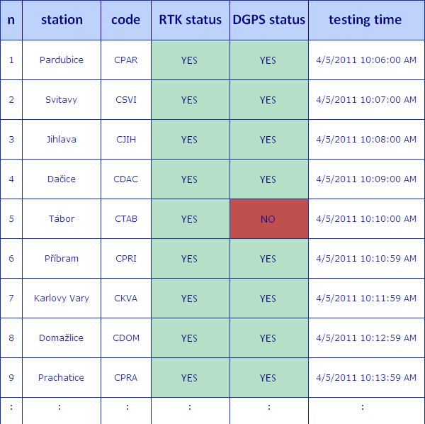
9 CZEPOS permanent check of the network solution - approach

10 CZEPOS permanent check of the network solution - results

11 CZEPOS monitoring of stability
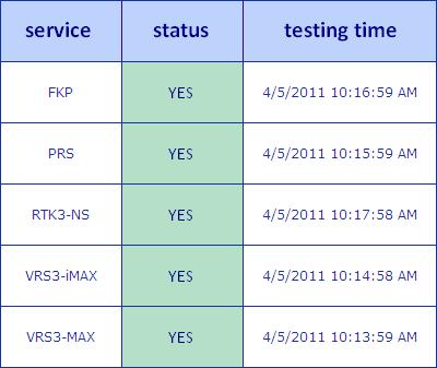
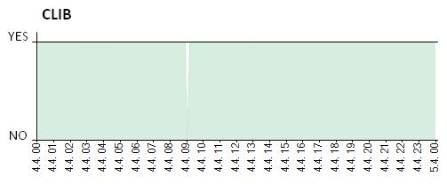
12 CZEPOS: Functionality of services


13 CZEPOS monitoring of quality of PP products based on Leica Geosystem GNSS QC SW Data Completeness Tracked Satellites PDOP Latency

14 CZEPOS availability of PP data

15 CZEPOS increasing number of users: May users
16 EPN Local Analysis Center GOP data analysis from 79 IGS/EPN + 49 Czech PS EPN standards and processing strategy Interruption in summer 2010; resumed Feb 2011 Reprocessing of 85 stations (Repro 1 project), extended to June 2010 precise GLONASS ultra-rapid orbits hourly data files from RT streams NRT ZTD procedure extended to GLONASS EPN routine processing extended to rapid and hourly solutions GPS week 1632: IGS08, new IGS phase centre model Monitoring of permanent stations in the Czech Republic

17 EPN Local Analysis Center GOP: EPN subnetwork processed by LAC GOP
18 GNSS Meteorology at GOP NRT troposphere products for numerical weather forecasting: E_GVAP II project GOP strategy revised in 2010, global product developed Global NRT solution estimating ZTDs (90 stations) routinely since August 2010 Global solution sufficiently stable, accuracy equivalent to that from GOP regional solution
19 GOP rapid orbits Since June 2010 routinely GPS+GLONASS ultra-rapid orbits GLONASS solution biased w.r.t. GPS (2 mm in ZTD) due to inconsistency of GPS and GLONASS antenna offsets from IGS05 ATX file Testing IGS08 ATX model commenced
20 Monitoring of the Czech permanent sites Check of stability and quality Rapid solution used as a basis EPN processing standards and guidelines 8:00 UTC the daily solution compared with coordinates + statistical test Limits: 7mm, 7 mm and 15 mm for N,E,U components
21 Monitoring results for the site CZNO (good) based on ultra-rapid solution
22 Monitoring results for the site CZHB (bad) based on ultra-rapid solution
23 ECGN, gravity, geodynamics 14 stations of the Czech Geodynamic Network in EUVN_DA_database 600 km of levelling lines in the geodynamic network (rms/1 km error 0.40 mm) Gravimetric measurements at 3 stations of the geodynamic network, geodynamic polygon Lišov, local gravity network GOP, vertical gravity gradients (performed by LSO) superconducting (OSG-050) and absolute gravimetry (FG5 No. 215) at GOP, environmental effects on gravity ICAG at Wettzell (6 absolute measurements) Absolute gravity measurements: Slovakia (4 sites), Hungary (3), Czech Republic (9 sites) Repeated absolute gravity measurements at GNSS permanent stations GOPE (14), POL1 (2), KUNZ (2) and ZDIB (3)

24 Geodynamical network of the Czech Republic Land Survey Office


25 Absolute gravity networks in CR and Slovakia measured by RIGTC-GOP with FG5 No 215


26 Tidal Gravimetry at GO Pecný and Environmental Effects gravity time series by GWR OSG-050, Askania Gs15 No. 228 and by LCR 137 calibration by FG5 No. 215 absolute gravimeter very broadband 3-D seismometer climatological station meteorological parameters soil moisture ground water level
27 Thank you for your attention! for more detailed information please visit
EUREF Related Activities in the Czech Republic
 Research Institute of Geodesy, Topography, and Cartography Geodetic Observatory Pecny Land Survey Office, Prague EUREF Related Activities in the Czech Republic 2012-2013 National Report J. Šimek 1, J.
EUREF Related Activities in the Czech Republic
 Research Institute of Geodesy, Topography, and Cartography Geodetic Observatory Pecny Land Survey Office, Prague EUREF Related Activities in the Czech Republic 2011-2012 National Report J. Šimek1, J. Douša1,
EUREF Related Activities in the Czech Republic
 Research Institute of Geodesy, Topography, and Cartography Geodetic Observatory Pecny Land Survey Office, Prague EUREF Related Activities in the Czech Republic 2014-2015 National Report J. Douša 1, V.
EUREF Related Activities in the Czech Republic
 Research Institute of Geodesy, Topography, and Cartography Geodetic Observatory Pecny Land Survey Office, Prague EUREF Related Activities in the Czech Republic 2015-2016 National Report J. Douša 1, V.
PosKEN Related Activities in the Czech Republic
 Research Institute of Geodesy, Topography, and Cartography Geodetic Observatory Pecny Land Survey Office, Prague PosKEN Related Activities in the Czech Republic 2014-2015 National Report J. Šimek 1 and
Integrated geodetic infrastructure at the Geodetic Observatory Pecný, Czech Republic, in service of national and international GNSS projects
 Integrated geodetic infrastructure at the Geodetic Observatory Pecný, Czech Republic, in service of national and international GNSS projects Pavel NOVÁK, Czech Republic Key words: geodesy, reference systems,
National Report of the Czech Republic EUREF Related Activities in the Czech Republic National Report. presented by J.
 Symposium of the IAG Subcommission for Europe (EUREF) Vienna, Austria, 1-4 June, 2005 National Report of the Czech Republic EUREF Related Activities in the Czech Republic 2004-2005 National Report presented
VESOG GNSS Network in Czech Republic
 1 VESOG GNSS Network in Czech Republic Jakub Kostelecký (RIGTC) JAKUB.KOSTELECKY@PECNY.CZ CzechGeo/EPOS Workshop November 16, 2016, GFU, Prague, Czech Republic VESOG GNSS network 2 VESOG = Research and
NATIONAL REPORT OF POLAND TO EUREF 2012
 NATIONAL REPORT OF POLAND TO EUREF 2012 Jan Krynski Institute of Geodesy and Cartography, Warsaw Jerzy B. Rogowski Warsaw University of Technology, Warsaw Outline Main geodetic activities at the national
EPN-Repro2: A Reference Tropospheric Dataset over Europe
 EPN-Repro2: A Reference Tropospheric Dataset over Europe R. Pacione (1), A. Araszkiewicz (2), E. Brockmann (3), J. Dousa (4) (1) e-geos S.p.A, ASI/CGS, Italy (2) Military University of Technology, Poland
Some Metrological Issues of GNSS Positioning: Case Study for the Czech Republic
 Some Metrological Issues of GNSS Positioning: Case Study for the Czech Republic Jaroslav Šimek Research Institute of Geodesy, Topography and Cartography - Geodetic Observatory Pecný The research is supported
OF POLAND TO EUREF 2009
 NATIONAL REPORT OF POLAND TO EUREF 2009 Jan Krynski Institute of Geodesy and Cartography, Warsaw Jerzy B. Rogowski Warsaw University of Technology, Warsaw Outline Main geodetic activities at the national
Updated Options and New Products of EPN Analysis
 EUREF Symposium in London, UK, 6 9 June 27 Updated Options and New Products of EPN Analysis H. Habrich EPN Analysis Coordinator Federal Agency for Cartography and Geodesy, Frankfurt, Germany Abstract The
ASG-EUPOS DENSIFICATION OF EUREF PERMANENT NETWORK ON THE TERRITORY OF POLAND
 ASG-EUPOS DENSIFICATION OF EUREF PERMANENT NETWORK ON THE TERRITORY OF POLAND 1. INTRODUCTION Jarosław Bosy 1,2) Artur Oruba 1) Wieslaw Graszka 1) Marcin Leonczyk 1) Marcin Ryczywolski 1) 1) Head Office
Advanced Global Navigation Satellite Systems tropospheric products for monitoring severe weather events and climate (GNSS4SWEC)
") Advanced Global Navigation Satellite Systems tropospheric products for monitoring severe weather events and climate (C) Y1 Y1 Y1 G. Guerova (1), J. Jones (2), J. Dousa (3), G. Dick (4), S. de Haan (5),
Advanced Global Navigation Satellite Systems tropospheric products for monitoring severe weather events and climate (C) Y1 Y1 Y1 G. Guerova (1), J. Jones (2), J. Dousa (3), G. Dick (4), S. de Haan (5),
EPN-related Activities at ASI/CGS
 EPN-related Activities at ASI/CGS R. Pacione, B. Pace, G. Colucci, e-geos ASI/CGS Matera, Italy G. Bianco, Agenzia Spaziale Italiana, CGS Matera, Italy ASI/CGS solutions delivered to EF Using IGS FINAL
LONG-TERM POSITIONAL MONITORING OF STATION VYHL OF THE SNĚŽNÍK NETWORK
 Acta Geodyn. Geomater., Vol. 4, No. 4 (148), 201-206, 2007 LONG-TERM POSITIONAL MONITORING OF STATION VYHL OF THE SNĚŽNÍK NETWORK Otakar ŠVÁBENSKÝ * and Josef WEIGEL Brno University of Technology, Department
Multi-GNSS real-time troposphere delay estimation
 Multi-GNSS real-time troposphere delay estimation Jaroslaw Bosy, Tomasz Hadas, Jak Kaplon, Kamil Kazmierski The 7th China Satellite Navigation Conference, May 18-20 Changsha China, Session S1: BDS/GNSS
Real-time PPP Results From Global Orbit and Clock Corrections
 BKG, Frankfurt a.m. Real-time PPP Results From Global Orbit and Clock Corrections Yüksel Altiner 1, Leos Mervart 2, Peter Neumaier 1, Wolfgang Söhne 1, Georg Weber 1 1 Federal Agency for Cartography and
Geodetic policy for Ireland and Northern Ireland
 Geodetic policy for Ireland and Northern Ireland Background Ordnance Survey Ireland (OSi) is the National Mapping Agency (NMA) of the Republic of Ireland. The Ordnance Survey of Northern Ireland (OSNI)
Enhancing the Swiss Permanent GPS Network (AGNES) for GLONASS
 for GLONASS") Enhancing the Swiss Permanent GPS Network (AGNES) for GLONASS D. INEICHEN, E. BROCKMANN, S. SCHAER 1 1 Abstract Since 1998 swisstopo has been operating the Automated GPS Network of Switzerland (AGNES)
Enhancing the Swiss Permanent GPS Network (AGNES) for GLONASS D. INEICHEN, E. BROCKMANN, S. SCHAER 1 1 Abstract Since 1998 swisstopo has been operating the Automated GPS Network of Switzerland (AGNES)
Towards a EUREF Service Providing Real-time GNSS Clock and Orbit Corrections
 Towards a EUREF Service Providing Real-time GNSS Clock and Orbit Corrections G. Weber 1), W. Söhne 1), A. Stürze 1), L. Mervart 2) 1) Federal Agency for Cartography and Geodesy, Frankfurt am Main, Germany
National report of Ukraine
 National report of Ukraine O. Kucher (1), A. Marchenko (3), O. Renkevich (1), S. Savchuk (3), I. Zaiats (2) 1) Research Institute of Geodesy and Cartography, Kyiv, Ukraine 2) State Service of Geodesy,
The realization of a 3D Reference System
 The realization of a 3D Reference System Standard techniques: topographic surveying and GNSS Observe angles and distances either between points on the Earth surface or to satellites and stars. Do not observe
EUREF Permanent GNSS Network Carine Royal Observatory of Belgium
 ENEON first workshop Observing Europe: Networking the Earth Observation Networks in Europe EUREF Permanent GNSS Network Carine Bruyninx/C.Bruyninx@oma.be Royal Observatory of Belgium 1. About your network
National report of Finland
 National report of Finland Matti Ollikainen, Jorma Jokela, Markku Poutanen, Ruizhi Chen and Jaakko Mäkinen, Finnish Geodetic Institute, P.O.Box 15, 02431 Masala, Finland EUREF Symposium 2006, June 14-17,
SKPOS NOT ONLY POSITIONING SERVICE R&D PROJECTS SUPPORTER
 SKPOS NOT ONLY POSITIONING SERVICE R&D PROJECTS SUPPORTER Ing. Branislav Droščák, PhD. Geodetic and Cartographic Institute BRATISLAVA branislav.droscak@skgeodesy.sk International scientific and methodological
GNSS Analysis with Galileo Observations in the Subnetwork of the BEK Analysis Centre
 GNSS Analysis with Galileo Observations in the Subnetwork of the BEK Analysis Centre Christof Völksen Bavarian Academy of Sciences and Humanities (BAdW) Tomasz Liwosz Warsaw University of Technology, Warsaw,
International Foundation HFSJG Activity Report 2016
 Name of research institute or organization: Bundesamt für Landestopografie / Swiss Federal Office of Topography (swisstopo) Title of project: Automated GNSS Network Switzerland (AGNES) Project leader and
Federal Office of Topography swisstopo LPT (swisstopo) EPN analysis center and the switch to Bernese GNSS Software V5.2
 EPN analysis center and the switch to Bernese GNSS Software V5.2") LPT (swisstopo) EPN analysis center and the switch to Bernese GNSS Software V5.2 D. Ineichen, E. Brockmann, S. Schaer LPT s contribution for the EPN 52 stations (from France to Estonia) Development of
LPT (swisstopo) EPN analysis center and the switch to Bernese GNSS Software V5.2 D. Ineichen, E. Brockmann, S. Schaer LPT s contribution for the EPN 52 stations (from France to Estonia) Development of
Real-Time and Multi-GNSS Key Projects of the International GNSS Service
 Real-Time and Multi-GNSS Key Projects of the International GNSS Service Urs Hugentobler, Chris Rizos, Mark Caissy, Georg Weber, Oliver Montenbruck, Ruth Neilan EUREF 2013 Symposium Budapest, Hungary, May
National Report of Austria
 National Report of Austria EUREF 05 Vienna 1.6-3.6. 2005 Ernst Zahn - BEV Vienna ISR - Space Research Institute / Austrian Academy of Sciences - Österreichische Akademie der Wissenschaften (ÖAW) BEV -
Establishment of Karadeniz Technical University Permanent GNSS Station As Reactivated of TRAB IGS Station
 Establishment of Karadeniz Technical University Permanent GNSS Station As Reactivated of TRAB IGS Station Selma Zengin Kazancı, Emine Tanır Kayıkçı Karadeniz Technical University, Department of Geomatics
Results from the Reprocessing of the BEK subnetwork
 Results from the Reprocessing of the BEK subnetwork Christof Völksen Commission for International Geodesy (BEK) Bayerische Kommission für die Internationale Erdmessung EUREF Symposium London 2007 Background
EUREF 12: National Report of Austria
 EUREF 12: National Report of Austria N.Höggerl 1, J.Otter 1, D.Ruess 1, G.Stangl 2, E.Zahn 1, S.Krauss 3, H.-P.Ranner 3 1. Positioning 1.1 GGOS/GIAC GGOS is the Global Geodetic Observing System of the
From Passive to Active Control Point Networks Evaluation of Accuracy in Static GPS Surveying
 From Passive to Active Control Point Networks Evaluation of Accuracy in Static GPS Surveying P. Häkli 1, U. Kallio 1 and J. Puupponen 2 1) Finnish Geodetic Institute 2) National Land Survey of Finland
Report of the Troposphere Coordinator
 Report of the Troposphere Coordinator R. Pacione e-geos, ASI/CGS-Matera, Italy 1 Outline Key Milestone in the EPN Tropospheric Products GNSS-Meteorology Concept EPN ZTD Time Series - 2 nd EPN Reprocessing
Precise GNSS analyses for troposphere monitoring by Geodetic Observatory Pecný analysis center
 Precise GNSS analyses for troposphere monitoring by Geodetic Observatory Pecný analysis center Douša Jan, Václavovic Pavel Research Institute of Geodesy, Topography and Cartography (RIGTC) JAN.DOUSA@PECNY.CZ
Issues Related to the Use of Absolute GPS/GLONASS PCV Models
 Bundesamt für Landestopografie Office fédéral de topographie Ufficio federale di topografia Uffizi federal da topografia Issues Related to the Use of Absolute GPS/GLONASS PCV Models S. Schaer 1, U. Hugentobler
Real-time Water Vapor and TEC calculation using existing GNSS reference station infrastructure. Rana Charara Trimble Infrastructure
 Real-time Water Vapor and TEC calculation using existing GNSS reference station infrastructure Rana Charara Trimble Infrastructure GNSS Netwoks International GNSS Network and Meteorological Products IGS
EUREF'02: National Report of Switzerland
 30 EUREF'0: National Report of Switzerland New Developments in Swiss National Geodetic Surveying D. SCHNEIDER, E. BROCKMANN, U. MARTI, A. SCHLATTER, TH. SIGNER, A. WIGET, U. WILD 1 1. Introduction The
Precise Point Positioning Developments at GSD: Products, Services
 Precise Point Positioning Developments at GSD: Products, Services F. Lahaye, P. Collins, Y. Mireault, P. Tétreault, M. Caissy Geodetic Survey Division, Natural Resources Canada (NRCan) GEOIDE - PPP Workshop
Global Navigation Satellite System data processing at near real time
 Global Navigation Satellite System data processing at near real time Martin Imrišek Slovak University of Technology in Bratislava Department of Theoretical Geodesy & Slovak Hydrometeorological Institute
Homogeneous tropospheric path delays from GNSS re-processing by GOP
 Homogeneous tropospheric path delays from GNSS re-processing by GOP Jan Douša, Pavel Václavovic, Michal Eliaš, RIGTC, The Czech Republic jan.dousa@pecny.cz June 6-8, 2016, Budapest, Hungary Outline 2 Introduction
Detection of Abnormal Ionospheric Activity from the EPN and Impact on Kinematic GPS positioning
 Detection of Abnormal Ionospheric Activity from the EPN and Impact on Kinematic GPS positioning N. Bergeot, C. Bruyninx, E. Pottiaux, S. Pireaux, P. Defraigne, J. Legrand Royal Observatory of Belgium Introduction
GUIDELINES FOR EPN STATIONS & OPERATIONAL CENTRES
 Guidelines for EPN Stations & Operational Centres Page 1 of 16 GUIDELINES FOR EPN STATIONS & OPERATIONAL CENTRES EPN Central Bureau C. Bruyninx, epncb@oma.be Updates: Regional data centre OLG is replaced
Terrestrial Reference Frame of Serbia and its temporal rate
 Belgrade University Faculty of Civil Engineering Terrestrial Reference Frame of Serbia and its temporal rate Sofija Naod, Sanja Grekulović, Violeta Vasilić Oleg Odalović, Dragan Blagojević Department of
Contributions of Onsala Space Observatory to GGOS
 Contributions of Onsala Space Observatory to GGOS R. Haas, G. Elgered, T. Hobiger, H.-G. Scherneck, J. Johansson Abstract The Onsala Space Observatory (OSO) on the Swedish west coast is the fundamental
EUPOS - EUROPEAN POSITION DETERMINATION SYSTEM INITIATIVE
 EUPOS - EUROPEAN POSITION DETERMINATION SYSTEM INITIATIVE Dr. Branislav Droščák EUPOS chairman & Geodetic and Cartographic institute Bratislava CLGE General Assembly March 22.-23. 2019. Sofia, Bulgaria
Status and plans for reference networks and systems in Denmark The Geodetic Infrastructure in Europe Umeå - Sweden, June 22-23, 2011
 Status and plans for reference networks and systems in Denmark The Geodetic Infrastructure in Europe Umeå - Sweden, June 22-23, 2011 Mette Weber and Lola Bahl National Survey and Cadastre - Denmark Content
Guidelines for EUREF Densifications
 Guidelines for EUREF Densifications Carine Bruyninx, ROB EUREF Tutorial May 24, 2016 San Sebastian, Spain EPN CB: www.epncb.oma.be ftp://epncb.oma.be/pub/general/guidelines_ for_euref_densifications.pdf
TESTING OF GNSS MULTIPATH IN DIFFERENT OBSERVATIONAL CONDITIONS AT ONE STATIONARY STATION
 Acta Geodyn. Geomater., Vol. 4, No. 43 (88), 45 49, 07 DOI: 0.368/AGG.07.003 journal homepage: https://www.irsm.cas.cz/acta ORIGINAL PAPER TESTING OF GNSS MULTIPATH IN DIFFERENT OBSERVATIONAL CONDITIONS
Geodetic Reference Frame Theory
 Technical Seminar Reference Frame in Practice, Geodetic Reference Frame Theory and the practical benefits of data sharing Geoffrey Blewitt University of Nevada, Reno, USA http://geodesy.unr.edu Sponsors:
The International GNSS Service (IGS): Product and Services
: Product and Services") The International GNSS Service (IGS): Product and Services Ruth E. Neilan 1, Chris Rizos 2 1 Director, IGS Central Bureau, NASA/JPL, Pasadena, USA 2 VP IAG, IGS Governing Board, UNSW, Sydney, Australia
The International GNSS Service (IGS): Product and Services Ruth E. Neilan 1, Chris Rizos 2 1 Director, IGS Central Bureau, NASA/JPL, Pasadena, USA 2 VP IAG, IGS Governing Board, UNSW, Sydney, Australia
GNSS Ionosphere Analysis at CODE
 GNSS Ionosphere Analysis at CODE Stefan Schaer 2004 IGS Workshop Berne, Switzerland March 1-5 Time Series of Global Mean TEC Covering Nearly One Solar Cycle as Generated at CODE 1 Exceptionally High TEC
GNSS zenith delays and gradients in the analysis of VLBI Intensive sessions
 GNSS zenith delays and gradients in the analysis of VLBI Intensive sessions Kamil Teke (1), Johannes Böhm (2), Matthias Madzak (2), Younghee Kwak (2), Peter Steigenberger (3) (1) Department of Geomatics
Real-Time GNSS EUREF-IP Pilot Project
 Real-Time GNSS EUREF-IP Pilot Project G. Weber, BKG, Frankfurt 1. Status: Network, coverage, contributors 2. White Paper: Real-time GNSS in Routine EPN Operations 3. Real-time GNSS tools: BNC, client for
National Report of Greece to EUREF 2010
 National Report of Greece to EUREF 2010 M. Gianniou KTIMATOLOGIO S.A. (Hellenic Cadastre) 1 Introduction The HEllenic POsitioning System (HEPOS) is an RTK network consisting of 98 reference stations that
THE PERMANENT MODRA-PIESOK GPS STATION MODRA- PIESOK AND ITS LONG-TERM AND SHORT-TERM STABILITY
 Slovak Journal of Civil Engineering, Vol. IX, No. 1-2, 2001 THE PERMANENT MODRA-PIESOK GPS STATION MODRA- PIESOK AND ITS LONG-TERM AND SHORT-TERM STABILITY Ján Hefty, Ph.D, Assoc. Prof. Department of Theoretical
NATIONAL REPORT OF POLAND TO EUREF 2017
 NATIONAL REPORT OF POLAND TO EUREF 2017 Jan Krynski Institute of Geodesy and Cartography, Warsaw Jerzy B. Rogowski Gdynia Maritime University Main geodetic activities at the national level in Poland since
EUPOS - European Position Determination System Status and current issues
 EUPOS - European Position Determination System Status and current issues Office of the International EUPOS Steering Committee Senate Department for Urban Development, Land Berlin, Germany Symposium of
GUIDANCE NOTES FOR GNSS NETWORK RTK SURVEYING IN GREAT BRITAIN
 GUIDANCE NOTES FOR GNSS NETWORK RTK SURVEYING IN GREAT BRITAIN ISSUE 4 MAY 2015 TSA Collaboration between: This leaflet has been produced to provide surveyors, engineers and their clients with guidelines
The IGS Real-time Pilot Project
 The IGS Real-time Pilot Project The Development of Real-time IGS Correction Products for Precise Point Positioning Mark Caissy, Georg Weber, Loukis Agrotis, Gerhard Wübbena, and Manuel Hernández-Pajares
ASG-EUPOS reference system
 Head Office of Geodesy and Cartography Department of Geodesy, Cartography and GIS ASG-EUPOS reference system Last year activities and future plans Szymon Wajda Prime specialist Bratislava, 21-22.11.2017
NATIONAL REPORT OF POLAND TO EUREF 2016
 NATIONAL REPORT OF POLAND TO EUREF 2016 Jan Krynski Institute of Geodesy and Cartography, Warsaw Jerzy B. Rogowski Gdynia Maritime University Main geodetic activities at the national level in Poland since
SLR residuals to GPS / GLONASS and combined GNSS-SLR analysis
 SLR residuals to GPS / GLONASS and combined GNSS-SLR analysis D. Thaller, K. Sośnica, R. Dach, A. Jäggi, C. Baumann Astronomical Institute, University of Bern, Switzerland International Technical Laser
What makes the positioning infrastructure work. Simon Kwok Chairman, Land Surveying Division Hong Kong Institute of Surveyors
 What makes the positioning infrastructure work The experience of the Hong Kong Satellite Positioning Reference Station Network Simon Kwok Chairman, Land Surveying Division Hong Kong Institute of Surveyors
Assessing the Impact of the SCIGN Radome on Geodetic Parameter Estimates
 Assessing the Impact of the SCIGN Radome on Geodetic Parameter Estimates John J. Braun UCAR/COSMIC Program P.O. Box 3000, Boulder, CO braunj@ucar.edu 303.497.8018 Introduction The SCIGN radome is widely
The importance of correct antenna calibration models for the EUREF Permanent Network
 73 The importance of correct antenna calibration models for the EUREF Permanent Network CH. VÖLKSEN 1 Abstract Station coordinates and velocities are derived today with a precision of a few millimetres.
AUSPOS GPS Processing Report
 AUSPOS GPS Processing Report February 13, 2012 This document is a report of the GPS data processing undertaken by the AUSPOS Online GPS Processing Service (version: AUSPOS 2.02). The AUSPOS Online GPS
magicgnss: QUALITY DATA, ALGORITHMS AND PRODUCTS FOR THE GNSS USER COMMUNITY
 SEMANA GEOMATICA 2009 magicgnss: QUALITY DATA, ALGORITHMS AND PRODUCTS FOR THE GNSS USER COMMUNITY MARCH 3, 2009 BARCELONA, SPAIN SESSION: GNSS PRODUCTS A. Mozo P. Navarro R. Píriz D. Rodríguez March 3,
National Report of Greece to EUREF 2009
 National Report of Greece to EUREF 2009 M. Gianniou KTIMATOLOGIO S.A. (Hellenic Cadastre) 1 Introduction In 2007, KTIMATOLOGIO S.A (Hellenic Cadastre) established HEPOS, the HEllenic POsitioning System,
DYNAMIC RT TECHNOLOGY
 DYNAMIC RT TECHNOLOGY GLOBAL NAVIGATION SATELLITE SYSTEMS (GNSS) POTENTIAL FUTURE DEVELOPMENTS(2005 2017?) GPS MODERNIZATION BLOCK IIF & III GLONASS ENHANCEMENTS (K & M) EUROPEAN UNION - GALILEO CHINA
Proposed standard for permanent GNSS reference stations in the Nordic countries
 Version 0.6 2003-05-15 Proposed standard for permanent GNSS reference stations in the Nordic countries Introduction Subproject A0 of the project Nordic Real-time Positioning Service Gunnar Hedling, Finn
Global Products for GPS Point Positioning Approaching Real-Time
 Global Products for GPS Point Positioning Approaching Real-Time Y. Gao 1, P. Heroux 2 and M. Caissy 2 1 Department of Geomatics Engineering, University of Calgary 2 Geodetic Survey Division, Natural Resources
Processing Combined GPS/GLONASS Data at swisstopo s Local Analysis Center
 armasuisse Federal Office of Topography swisstopo Processing Combined GPS/GLONASS Data at swisstopo s Local Analysis Center D. Ineichen, E. Brockmann, S. Schaer GLONASS data used for EUREF solutions swisstopo
ROMPOS FOR CADASTRE APPLICATIONS
 International Symposium on Global Navigation Satellite Systems, Space-Based and Ground-Based Augmentation Systems and Applications 2009; Berlin, Germany, 30 November - 2 December 2009 ROMPOS FOR CADASTRE
EIG EUMETNET GNSS Water Vapour Programme E-GVAP
 EIG EUMETNET GNSS Water Vapour Programme E-GVAP Status of E-GVAP Henrik Vedel, hev@dmi.dk, DMI and E-GVAP team Siebren de Haan, siebren.de.haan@knmi.nl KNMI and E-GVAP team Jonathan Jones, jonathan.jones@metoffice.gov.uk,
DATA ASSIMILATION OF GNSS ZTD FROM THE NGAA PROCESSING CENTRE. Martin Ridal Magnus Lindskog, Sigurdur Thorsteinsson and Tong Ning
 DATA ASSIMILATION OF GNSS ZTD FROM THE NGAA PROCESSING CENTRE Martin Ridal Magnus Lindskog, Sigurdur Thorsteinsson and Tong Ning GNSS derived moisture Global Navigation Satellite System GPS, GLONASS, GALILEO,
Estimating Zenith Total Delay Residual Fields by using Ground-Based GPS network. Presented at EUREF Symposium 2010 Gävle,
 Estimating Zenith Total Delay Residual Fields by using Ground-Based GPS network B. PACE, R. PACIONE, C. SCIARRETTA, F. VESPE 2 e-geos, Centro di Geodesia Spaziale, 7500 Matera Italy 2 Agenzia Spaziale
TRANSMISSION OF CONTINUOUSLY RECORDED DATA FROM REMOTE GPS PERMANENT STATIONS TO IRSM CENTRAL UNIT
 Acta Geodyn. Geomater., Vol.2, No.3 (139), 69-73, 2005 TRANSMISSION OF CONTINUOUSLY RECORDED DATA FROM REMOTE GPS PERMANENT STATIONS TO IRSM CENTRAL UNIT František MANTLÍK*, Pavel KOTTNAUER, Vladimír SCHENK
Impact of Baseline Distance and Interstation Height Difference On the Accuracy of GPS- Derived Station Coordinates
 IOP Conference Series: Earth and Environmental Science PAPER OPEN ACCESS Impact of Baseline Distance and Interstation Height Difference On the Accuracy of GPS- Derived Station Coordinates To cite this
The Impact of Different GPS Antenna Calibration Models on the EUREF Permanent Network
 103 The Impact of Different GPS Antenna Calibration Models on the EUREF Permanent Network CH. VÖLKSEN 1, F. MENGE 2 Abstract It is generally known that the phase center of a GPS antenna is not a stable
Precise Positioning GNSS Applications
 Precise Point Positioning: Is the Era of Differential GNSS Positioning Drawing to an End? School of Surveying & Spatial Information Systems, UNSW, Sydney, Australia Chris Rizos 1, Volker Janssen 2, Craig
PERSPECTIVES OF FREE GNSS POST-PROCESSING SOFTWARE USING
 XIII International forum «INTEREXPO GEO-Siberia 2017» PERSPECTIVES OF FREE GNSS POST-PROCESSING SOFTWARE USING S. Shevchuk, L. Lipatnikov, K. Malyutina (Siberian State University of Geosystems and Technologies)
NATIONAL REPORT OF SLOVENIA
 27th EUREF Symposium NATIONAL REPORT OF SLOVENIA Klemen Medved, Sandi Berk, Žarko Komadina, Jurij Režek (Surveying and Mapping Authority of the Republic of Slovenia, Ljubljana) Niko Fabiani, Katja Oven
Cross-Border EUPOS Data Exchange First Experience
 Cross-Border EUPOS Data Exchange First Experience Eimuntas Paršeliūnas, Marius Petniūnas, Domantas Bručas (Institute of Geodesy of Vilnius Gediminas Technical University, Lithuania) Wieslaw Graszka (Head
Multi-Technique Reprocessing and Combination using Space-Ties
 Multi-Technique Reprocessing and Combination using Space-Ties Tim Springer, Florian Dilssner, Diego Escobar, Michiel Otten, Ignacio Romero, John Dow AGU 2009, San Francisco, CA, USA 14/12/2009 ESOC Reprocessing
Bernese GPS Software 4.2
 Bernese GPS Software 4.2 Introduction Signal Processing Geodetic Use Details of modules Bernese GPS Software 4.2 Highest Accuracy GPS Surveys Research and Education Big Permanent GPS arrays Commercial
WHU s developments for the MGEX precise products and the GNSS ultra-rapid products
 IGS Workshop 2016 WHU s developments for the MGEX precise products and the GNSS ultra-rapid products Chuang Shi; Qile Zhao; Min Li; Jing Guo; Jingnan Liu Presented by Jianghui Geng GNSS Research Center,
EUREF-Czech-2009 Campaign
 Research Institute of Geodesy, Topography and Cartography Ústecká 98, 250 66 Zdiby, Czech Republic EUREF-Czech-2009 Campaign Final Report submitted for evaluation by the EUREF Technical Working Group prepared
Alberding solutions for GNSS infrastructure operators
 Tamás Horváth Alberding solutions for GNSS infrastructure operators 21.11.2017 1/35 Alberding solutions for GNSS infrastructure operators Tamás Horváth Alberding GmbH 4 th EUPOS Technical Meeting 21-22
EUPOS: Unified GNSS Augmentation Infrastructure and International Cooperation in Central and Eastern Europe
 EUPOS: Unified GNSS Augmentation Infrastructure and International Cooperation in Central and Eastern Europe Senate Department for Urban Development Geodetic Reference Systems Fehrbelliner Platz 1, 10707
KOPOS (KOsovo POsitioning System) ANALYSIS IN THE TESTING PHASE
 ANALYSIS IN THE TESTING PHASE") KOPOS (KOsovo POsitioning System) ANALYSIS IN THE TESTING PHASE Murat Meha Muzafer Çaka Reshat Murati 3 CROPOS Conference, Opatija, 24-25 October 2013 1 Chronology of system development Owner of the system:
KOPOS (KOsovo POsitioning System) ANALYSIS IN THE TESTING PHASE Murat Meha Muzafer Çaka Reshat Murati 3 CROPOS Conference, Opatija, 24-25 October 2013 1 Chronology of system development Owner of the system:
NATIONAL REPORT OF BULGARIA
 CENTRAL LABORATORY OF GEODESY MILITARY GEOGRAPHIC SERVICE GEODESY, CARTOGRAPHY AND CADASTRE AGENCY NATIONAL REPORT OF BULGARIA Ivan GEORGIEV 1, Georgi GLADKOV 2, Plamen GABENSKI 2, Toshko TASHKOV 2, Peter
The HUNREF2002 Campaign: Re-establishment of the EUREF Network in Hungary
 The HUNREF2002 Campaign: Re-establishment of the EUREF Network in Hungary Kenyeres, A. Borza,T. Virág,G. FOMI Satellite Geodetic Observatory H-1592 Budapest, P.O.Box 585. e-mail: kenyeres@sgo.fomi.hu 1.Introduction
The IEODO THEFIRSTRESULTS OFANALYSINGGPS OBSERVATIONS AT IEODO OCEAN RESEARCH STATION IN KOREA
 THEFIRSTRESULTS OFANALYSINGGPS OBSERVATIONS AT IEODO OCEAN RESEARCH BYUNGMOON PARK STATION IN KOREA DEPARTMENT OF GEOINFORMATICS, UNIVERSITY OF SEOUL, KOREA DR. TAJUL ARIFFIN MUSA GNSS & GEODYNAMICS RESEARCH
SIRGAS: the geodetic reference frame for Latin America and the Caribbean
 SIRGAS: the geodetic reference frame for Latin America and the Caribbean C. Brunini UNLP, Argentina L. Sánchez DGFI, Germany V. Mackern UNCuyo, UJAM, Argentina W. Martínez IGAC, Colombia R. Luz IBGE, Brazil
EUPOS European Position Determination System
 EUPOS European Position Determination System c/o Senate Department for Urban Development, State Berlin, Germany Umea, Sweden, 22 nd 23 rd 2011 The Geodetic Infrastructure in Europe today and tomorrow Slide
Keywords: GPS/GLONASS, Precise Point Positioning, Kinematic, Hydrography
 GPS/GLONASS COMBINED PRECISE POINT POSITIOINING FOR HYDROGRAPHY CASE STUDY (ASWAN, EGYPT) Ashraf Farah Associate Professor,College of Engineering, Aswan University, Egypt, ashraf_farah@aswu.edu.eg ABSTRACT