NATIONAL REPORT OF BULGARIA
|
|
|
- Austin Butler
- 5 years ago
- Views:
Transcription


1 CENTRAL LABORATORY OF GEODESY MILITARY GEOGRAPHIC SERVICE GEODESY, CARTOGRAPHY AND CADASTRE AGENCY NATIONAL REPORT OF BULGARIA
2 Ivan GEORGIEV 1, Georgi GLADKOV 2, Plamen GABENSKI 2, Toshko TASHKOV 2, Peter DANCHEV 2, Dimitar DIMITROV 1, Tassi BELYASHKI 1, Tsveten BOEV 3, Momchil MINCHEV 4 1 Central Laboratory of Geodesy 2 Military Geographic Service 3 Geodesy, Cartography and Cadastre Agency 4 University of Mining and Geology
3 Further development and maintenance of the National GPS Network GPS campaign for velocity estimation of the 25 EUREF points Precise levelling of all National GPS Network points Gravity measurements of the 25 EUREF points Joining the National levelling network to EVRS Development of a permanent GPS array in Bulgaria Deployment of permanent stations GPS permanent stations data processing Drafting specifications Main Activities
4 Further development and maintenance of the National GPS Network GPS campaign for velocity estimation of the 25 EUREF poi nts Precise levelling of all National GPS Network points Gravity measurements of the 25 EUREF points
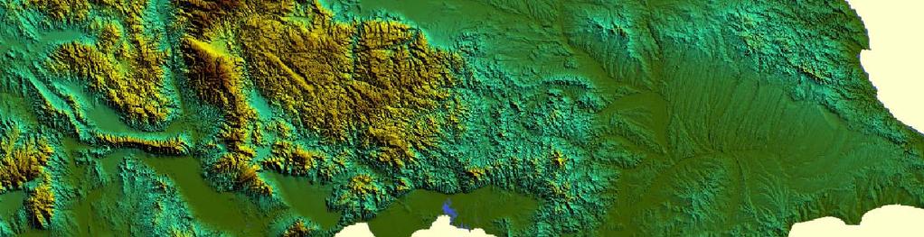
5 National GPS Network Primary points

6 National GPS Network Secondary points
7 National GPS Network Maintenance 8425 Replaced Destroyed 8426 Replaced Destroyed Repaired Destroyed

8 VIDI BERK SOFI PAKO Velocities have been derived ZARA for these types of points PETR SAPA Bulgarian EUREF points KOVA SATO BRAG GULI NOVE GABR ASEN KIRK To estimate velocities of these points, an observation campaign was carried out in 2007 TURA HARM ZVEZ SHUM SMOL VATG BURG KERM BUTG MAMA KAVA IGS/EPN Stations EUREF 1992/93 Points EUREF/BULREF Points EUVN/BULREF Points EUREF/NGPSN Points
9 The 2007 GPS campaign Purpose To obtain a second observation epoch of the 10 new EUREF points endorsed at the 2006 EUREF symposium in Riga Participants Central Laboratory of Geodesy Military Geographic Service Campaign details Equipment: 10 Trimble receivers Session length: 62 hours


10 Precise levelling of NGPSN points In 2006 MGS started precise levelling of primary and secondary National GPS Network points. The heights of 64 of totally 112 primary points are determined All lines are double observed using Topcon DL-101C levels and tied to first and second order benchmarks Totally ~ 200 km levelling lines are observed in 2007
11 Gravity measurements at Bulgarian EUREF points VIDI TURA SMOL KOVA KAVA NOVE GULI SHUM VATG BERK BRAG ZVEZ BURG GABR SOFI PAKO KERM ZARA SAPA BUTG HARM MAMA ASEN SATO PETR IGS/EPN Stations KIRK EUREF 1992/93 Points In 2007 relative gravity measurements at all Obtained Bulgarian are gravity EUREF differences points with EUREF/BULREF Points are performed regard Typical to rms National of about gravity 0.2 mgal network is achieved EUVN/BULREF Points points using GAK-7T and GR/K2 EUREF/NGPSN Points gravity meters
12 Joining the National Levelling Network to EVRS
13 National Levelling Network First Order Outlook 55 levelling lines, total length 5630 km 4530 levelling points, of them 330 fundamental benchmarks 33 nodal points, 23 loops 6 cross-border connections to Romania Observations Last observation cycle Average epoch 1979 Accuracy of 1 km double levelled line 0.40 mm Results Geopotential numbers and normal heights Referred to the EVRS2007 system
14 National Levelling Network Second Order Outlook 252 levelling lines, total length 8650 km 6130 benchmarks Observations Observation cycle Accuracy of 1 km double levelled line 0.59 mm Referred to UELN-95/17 To be recomputed Constrained by 73 nodal points obtained from the First Order Reference system EVRS2007
15 Height system intercomparison Baltic System Kronstadt The transformation parameters between EVRS2007 and the former national height system (Baltic) The difference are: between EVRS2007 and UELN95/ kgal is: in geopotential numbers kgal mm in in geopotential normal heights numbers 44.5 mm in normal heights Black Sea UELN95/17 Amsterdam EVRS datum points
16 Development of a GPS Array in Bulgaria Deployment of permanent GPS stations GPS permanent stations data processing
17 Deployment of permanent GPS stations Joint efforts of both institutions Central Laboratory of Geodesy Military Geographic Service Private companies provide 30 sec files At the moment, totally 17 permanent GPS/GNSS stations submit data to CLG analysis center for routine processing


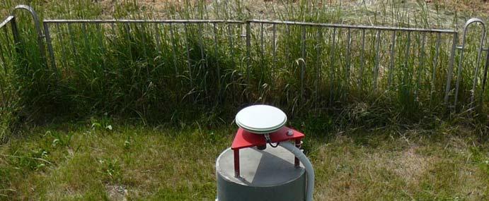
18 SOFI IGS/EPN Station SOFI
19 NAVITEQ Network VARS SOF1 RIBA BOBO VELI RAKO PRIM
20 NAVITEQ Reference Station
21 HEMUS Net DRAG SOFA KUST PAZA SAND YUND


22 HemusNET Reference Station
23 Other permanent stations Provadia Varna TROY Plovdiv * Rozhen
24 GPS/GNSS permanent stations in Bulgaria as of June 2008 VARS Provadia Varna DRAG SOF1 SOFA RIBA TROY SOFI KUST BOBO VELI YUND SAND PAZA RAKO Plovdiv Rozhen PRIM
25 GPS permanent stations data processing Basics of the processing strategy Processing status (as of June 2008)
26 Basics of the processing strategy GAMIT/GLOBK Version IGS satellite orbits and USNO pole coordinates ITRF2005 reference system IGS_05 absolute model of antenna phase centre variations (elevation dependent phase centre corrections) Observation weights depend on the height above horizon Loosely constrained daily solutions Reference frame defined at the GLOBK stage
27 Processing status (as of June 2008) Data available Span length: 8 months Sampling rate: 30 sec Estimated parameters Station coordinates Zenith delays, gradients Ambiguities Results Row time series Detrended time series

28 Row series NAVITEQ RIBA station Detrended series
29 Row series HemusNET SAND station Detrended series
30 Drafting GNSS specifications Existing specifications, issued 1995, are out of date and not adequate to: Current technology GNSS status Existing and developing GNSS networks and infrastructure Why do we need specifications Institutions are responsible for national control networks, and do not provide services Private companies began realization of GNSS infrastructure projects Investors and contractors need specifications to define and verify project requirements Service providers need it for product validation
31 Drafting GNSS specifications (2) Draft status First draft completed May 2008 Draft revision and coordination in progress Finalization due Autumn 2008
32 THANK YOU FOR YOUR ATTENTION
National Report of Austria
 National Report of Austria EUREF 05 Vienna 1.6-3.6. 2005 Ernst Zahn - BEV Vienna ISR - Space Research Institute / Austrian Academy of Sciences - Österreichische Akademie der Wissenschaften (ÖAW) BEV -
National report of Ukraine
 National report of Ukraine O. Kucher (1), A. Marchenko (3), O. Renkevich (1), S. Savchuk (3), I. Zaiats (2) 1) Research Institute of Geodesy and Cartography, Kyiv, Ukraine 2) State Service of Geodesy,
Guidelines for EUREF Densifications
 Guidelines for EUREF Densifications Carine Bruyninx, ROB EUREF Tutorial May 24, 2016 San Sebastian, Spain EPN CB: www.epncb.oma.be ftp://epncb.oma.be/pub/general/guidelines_ for_euref_densifications.pdf
National Report of Bulgaria
 National Report of Bulgaria G. MILEV 1, M. MINCHEV 2, K. VASSILEVA 1, T. TASHKOV 3, G. PETROV 3, G. VALEV 4, T. BELJASHKI 5 Abstract The main activities on the EUREF have been outlined. The operation of
Time series analysis of the French GPS Permanent Network (RGP)
") Time series analysis of the French GPS Permanent Network (RGP) Bruno Garayt Zuheir ltamimi Motivations ETRS89 coordinates for the RGP stations Improving / replacing the old RGF93 solution RGP maintenance
Time series analysis of the French GPS Permanent Network (RGP) Bruno Garayt Zuheir ltamimi Motivations ETRS89 coordinates for the RGP stations Improving / replacing the old RGF93 solution RGP maintenance
Terrestrial Reference Frame of Serbia and its temporal rate
 Belgrade University Faculty of Civil Engineering Terrestrial Reference Frame of Serbia and its temporal rate Sofija Naod, Sanja Grekulović, Violeta Vasilić Oleg Odalović, Dragan Blagojević Department of
Updated Options and New Products of EPN Analysis
 EUREF Symposium in London, UK, 6 9 June 27 Updated Options and New Products of EPN Analysis H. Habrich EPN Analysis Coordinator Federal Agency for Cartography and Geodesy, Frankfurt, Germany Abstract The
NATIONAL REPORT OF SLOVENIA
 27th EUREF Symposium NATIONAL REPORT OF SLOVENIA Klemen Medved, Sandi Berk, Žarko Komadina, Jurij Režek (Surveying and Mapping Authority of the Republic of Slovenia, Ljubljana) Niko Fabiani, Katja Oven
IAG School on Reference Systems June 7 June 12, 2010 Aegean University, Department of Geography Mytilene, Lesvos Island, Greece SCHOOL PROGRAM
 IAG School on Reference Systems June 7 June 12, 2010 Aegean University, Department of Geography Mytilene, Lesvos Island, Greece SCHOOL PROGRAM Monday June 7 8:00-9:00 Registration 9:00-10:00 Opening Session
GPS Geodetic Reference System WGS 84
 GPS Geodetic Reference System WGS 84 International Committee on GNSS Working Group D Saint Petersburg, Russia 16 September 2009 Barbara Wiley National Geospatial-Intelligence Agency United States of America
Philippine Geodetic Infrastructure Status, Challenges and Future Direction
 Philippine Geodetic Infrastructure Status, Challenges and Future Direction Engr. Charisma Victoria D. Cayapan National Mapping and Resource Information Authority PHILIPPINES Outline Evolution of Geodetic
The realization of a 3D Reference System
 The realization of a 3D Reference System Standard techniques: topographic surveying and GNSS Observe angles and distances either between points on the Earth surface or to satellites and stars. Do not observe
The HUNREF2002 Campaign: Re-establishment of the EUREF Network in Hungary
 The HUNREF2002 Campaign: Re-establishment of the EUREF Network in Hungary Kenyeres, A. Borza,T. Virág,G. FOMI Satellite Geodetic Observatory H-1592 Budapest, P.O.Box 585. e-mail: kenyeres@sgo.fomi.hu 1.Introduction
SIRGAS: the geodetic reference frame for Latin America and the Caribbean
 SIRGAS: the geodetic reference frame for Latin America and the Caribbean C. Brunini UNLP, Argentina L. Sánchez DGFI, Germany V. Mackern UNCuyo, UJAM, Argentina W. Martínez IGAC, Colombia R. Luz IBGE, Brazil
Salient Feature of ITRF. Realization of Dubai Emirate Datum. Reference Frame 2000 (Ditr 2000)
") Salient Feature of ITRF on the Reference Frame 2000 (Ditr 2000) ITRF stands for International Terrestrial Reference Frame ITRF established by the International Earth Rotation Service (IERS), France. One
Salient Feature of ITRF on the Reference Frame 2000 (Ditr 2000) ITRF stands for International Terrestrial Reference Frame ITRF established by the International Earth Rotation Service (IERS), France. One
EUREF Related Activities
 Symposium of the IAG Subcommission for Europe (EUREF) Chisinau, Moldova, 25 28 May, 2011 National Report of the Czech Republic EUREF Related Activities in the Czech Republic 2010-2011 National Report presented
From Passive to Active Control Point Networks Evaluation of Accuracy in Static GPS Surveying
 From Passive to Active Control Point Networks Evaluation of Accuracy in Static GPS Surveying P. Häkli 1, U. Kallio 1 and J. Puupponen 2 1) Finnish Geodetic Institute 2) National Land Survey of Finland
EUREF MAKPOS New realization of ETRS89 in Republic of Macedonia
 EUREF MAKPOS 2010 New realization of ETRS89 in Republic of Macedonia Saso Dimeski, Brankica Stojanovska, Srecko Tasevski (AREC), Mile Varoshlieski (Swedesurvey), Christina Lilje, Martin Lidberg, Lotti
ROMPOS FOR CADASTRE APPLICATIONS
 International Symposium on Global Navigation Satellite Systems, Space-Based and Ground-Based Augmentation Systems and Applications 2009; Berlin, Germany, 30 November - 2 December 2009 ROMPOS FOR CADASTRE
National Report of Greece to EUREF 2009
 National Report of Greece to EUREF 2009 M. Gianniou KTIMATOLOGIO S.A. (Hellenic Cadastre) 1 Introduction In 2007, KTIMATOLOGIO S.A (Hellenic Cadastre) established HEPOS, the HEllenic POsitioning System,
PERSPECTIVES OF FREE GNSS POST-PROCESSING SOFTWARE USING
 XIII International forum «INTEREXPO GEO-Siberia 2017» PERSPECTIVES OF FREE GNSS POST-PROCESSING SOFTWARE USING S. Shevchuk, L. Lipatnikov, K. Malyutina (Siberian State University of Geosystems and Technologies)
FieldGenius Technical Notes GPS Terminology
 FieldGenius Technical Notes GPS Terminology Almanac A set of Keplerian orbital parameters which allow the satellite positions to be predicted into the future. Ambiguity An integer value of the number of
AUSPOS GPS Processing Report
 AUSPOS GPS Processing Report February 13, 2012 This document is a report of the GPS data processing undertaken by the AUSPOS Online GPS Processing Service (version: AUSPOS 2.02). The AUSPOS Online GPS
CGG. Office of the Surveyor General of the Federation Federal Capital Territory, Abuja, Nigeria 2
 Prof. P. C. Nwilo 1, * Dr. J. D. Dodo 2, U. R. Edozie 1, and A. Adebomehin 1. 1 Office of the Surveyor General of the Federation Federal Capital Territory, Abuja, Nigeria 2 Centre for Geodesy and Geodynamics,
Performance Evaluation of the Effect of QZS (Quasi-zenith Satellite) on Precise Positioning
 on Precise Positioning") Performance Evaluation of the Effect of QZS (Quasi-zenith Satellite) on Precise Positioning Nobuaki Kubo, Tomoko Shirai, Tomoji Takasu, Akio Yasuda (TUMST) Satoshi Kogure (JAXA) Abstract The quasi-zenith
Performance Evaluation of the Effect of QZS (Quasi-zenith Satellite) on Precise Positioning Nobuaki Kubo, Tomoko Shirai, Tomoji Takasu, Akio Yasuda (TUMST) Satoshi Kogure (JAXA) Abstract The quasi-zenith
Kinematics of the SIRGAS Reference Frame
 Kinematics of the SIRGAS Reference Frame Laura Sánchez Deutsches Geodätisches Forschungsinstitut der Technischen Universität München (DGFI-TUM), Germany IGS Regional Network Associate Analysis Centre for
Towards a EUREF Service Providing Real-time GNSS Clock and Orbit Corrections
 Towards a EUREF Service Providing Real-time GNSS Clock and Orbit Corrections G. Weber 1), W. Söhne 1), A. Stürze 1), L. Mervart 2) 1) Federal Agency for Cartography and Geodesy, Frankfurt am Main, Germany
National report of Finland
 National report of Finland Matti Ollikainen, Jorma Jokela, Markku Poutanen, Ruizhi Chen and Jaakko Mäkinen, Finnish Geodetic Institute, P.O.Box 15, 02431 Masala, Finland EUREF Symposium 2006, June 14-17,
Principles of the Global Positioning System Lecture 19
 12.540 Principles of the Global Positioning System Lecture 19 Prof. Thomas Herring http://geoweb.mit.edu/~tah/12.540 GPS Models and processing Summary: Finish up modeling aspects Rank deficiencies Processing
Cors Networks And Investigation Of Point Positioning Accuracy Of Konya Permanent GNSS Network (Kosaga)
") Cors Networks And Investigation Of Point Positioning Accuracy Of Konya Permanent GNSS Network (Kosaga) Ayhan CEYLAN, Turkey Key words: GNSS, Cors-Tr, Kosaga SUMMARY Mankind has always wondered where it
Cors Networks And Investigation Of Point Positioning Accuracy Of Konya Permanent GNSS Network (Kosaga) Ayhan CEYLAN, Turkey Key words: GNSS, Cors-Tr, Kosaga SUMMARY Mankind has always wondered where it
National Report of Greece to EUREF 2010
 National Report of Greece to EUREF 2010 M. Gianniou KTIMATOLOGIO S.A. (Hellenic Cadastre) 1 Introduction The HEllenic POsitioning System (HEPOS) is an RTK network consisting of 98 reference stations that
GPS for crustal deformation studies. May 7, 2009
 GPS for crustal deformation studies May 7, 2009 High precision GPS for Geodesy Use precise orbit products (e.g., IGS or JPL) Use specialized modeling software GAMIT/GLOBK GIPSY OASIS BERNESE These software
STABILITY OF GLOBAL GEODETIC RESULTS
 STABILITY OF GLOBAL GEODETIC RESULTS Prof. Thomas Herring Room 54-611; 253-5941 tah@mit.edu http://bowie.mit.edu/~tah 04/22/02 EGS G6 2002 1 Overview Motivation for talk: Anomalies in apparent positions
Bernese GPS Software 4.2
 Bernese GPS Software 4.2 Introduction Signal Processing Geodetic Use Details of modules Bernese GPS Software 4.2 Highest Accuracy GPS Surveys Research and Education Big Permanent GPS arrays Commercial
Stations and Datum Transformation
 Continuously Operating Referene Stations and Datum Transformation (CORS-TR) Ali Kılıçoğlu Geodesy Department, GCM Turkey ali.kilicoglu@hgk.mil.tr EUREF 2009, 26-29 May 2009, Firenze, Italy 147 CORS 2 Control
Contribution of Jozefoslaw Astro-Geodetic Observatory and WUT LAC to EPN and Geodynamical Studies in Central Europe
 M. Kruczyk et al.: Contribution of Jozefoslaw and WUT LAC to EPN and Geodynamical Studies in Central Europe 369 Contribution of Jozefoslaw Astro-Geodetic Observatory and WUT LAC to EPN and Geodynamical
A Permanent GPS Array in Crete & the Cal/Val facility for satellite radar altimeters in Gavdos
 A Permanent GPS Array in Crete & the Cal/Val facility for satellite radar altimeters in Gavdos S. P. Mertikas Technical University f Crete EUREF 2007 Symposium, 6-96 9 June 2007, London, England Laboratory
Influence of network geometry on densification on the Faroe Islands 2011
 Influence of network geometry on densification on the Faroe Islands 2011 Shfaqat Abbas Khan 1, Mette Weber 2, Karsten Enggaard Engsager 1,2, and Per Knudsen 1 1 Department of Geodesy, National Space Institute
PageNET: In Support of the Surveying Community
 Philippine Active Geodetic Network : In Support of the Surveying Community ICG Experts Meeting: Global Navigation Satellite Systems Services Vienna International Center, Vienna, Austria December 14-18,
PosKEN Related Activities in the Czech Republic
 Research Institute of Geodesy, Topography, and Cartography Geodetic Observatory Pecny Land Survey Office, Prague PosKEN Related Activities in the Czech Republic 2014-2015 National Report J. Šimek 1 and
GNSS Application trends in Central Asia
 GNSS Application trends in Central Asia GIS Open 2014, April 15-17, 2014, Székesfehérvár, Hungary Akylbek Chymyrov PhD Candidate, Faculty of Geoinformatics University of West-Hungary Docent of the Geodesy
Geodetic policy for Ireland and Northern Ireland
 Geodetic policy for Ireland and Northern Ireland Background Ordnance Survey Ireland (OSi) is the National Mapping Agency (NMA) of the Republic of Ireland. The Ordnance Survey of Northern Ireland (OSNI)
GNSS & Coordinate Systems
 GNSS & Coordinate Systems Matthew McAdam, Marcelo Santos University of New Brunswick, Department of Geodesy and Geomatics Engineering, Fredericton, NB May 29, 2012 Santos, 2004 msantos@unb.ca 1 GNSS GNSS
Record 2013/01 GeoCat 75057
 Record 2013/01 GeoCat 75057 Determination of GDA94 coordinates for station CCMB at the Clermont Coal Mine of Rio Tinto Coal Australia (RTCA) in central Queensland using the October and November 2012 GPS
Presentation Plan. The Test of Processing Modules of Global Positioning System (GPS) Softwares by Using Products of International GPS Service (IGS)
 Softwares by Using Products of International GPS Service (IGS)") The Test of Processing Modules of Global Positioning System (GPS) Softwares by Using Products of International GPS Service (IGS) Presentation Plan 1. Introduction 2. Application 3. Conclusions Ismail SANLIOGLU,
The Test of Processing Modules of Global Positioning System (GPS) Softwares by Using Products of International GPS Service (IGS) Presentation Plan 1. Introduction 2. Application 3. Conclusions Ismail SANLIOGLU,
SIRGAS: BASIS FOR GEOSCIENCES, GEODATA, AND NAVIGATION IN LATIN AMERICA
 SIRGAS: BASIS FOR GEOSCIENCES, GEODATA, AND NAVIGATION IN LATIN AMERICA Laura Sánchez SIRGAS Vice-president Deutsches Geodätisches Forschungsintitut Munich, Germany Claudio Brunini SIRGAS President Universidad
TESTING OF GNSS MULTIPATH IN DIFFERENT OBSERVATIONAL CONDITIONS AT ONE STATIONARY STATION
 Acta Geodyn. Geomater., Vol. 4, No. 43 (88), 45 49, 07 DOI: 0.368/AGG.07.003 journal homepage: https://www.irsm.cas.cz/acta ORIGINAL PAPER TESTING OF GNSS MULTIPATH IN DIFFERENT OBSERVATIONAL CONDITIONS
GNSS buoy array in the ocean for natural hazard mitigation. Teruyuki KATO Earthquake Research Institute the University of Tokyo, Japan
 GNSS buoy array in the ocean for natural hazard mitigation Teruyuki KATO Earthquake Research Institute the University of Tokyo, Japan 1 GNSS applications in Earth science From static to high-rate observations
Connecting a Cadastral Survey to PNG94 using GNSS
 43rd Association of Surveyors PNG Congress, Lae, 12th-15th August 2009 Connecting a Cadastral Survey to PNG94 using GNSS Richard Stanaway QUICKCLOSE Workshop overview Legal requirements to connect surveys
Status and plans for reference networks and systems in Denmark The Geodetic Infrastructure in Europe Umeå - Sweden, June 22-23, 2011
 Status and plans for reference networks and systems in Denmark The Geodetic Infrastructure in Europe Umeå - Sweden, June 22-23, 2011 Mette Weber and Lola Bahl National Survey and Cadastre - Denmark Content
EUROPEAN POSITION DETERMINATION SYSTEM (EUPOS )
") 1 EUROPEAN POSITION DETERMINATION SYSTEM (EUPOS ) G. ROSENTHAL 1, G. MILEV 2, K. VASSILEVA 2 EUPOS: European Position Determination System 1. General 2. For position fixing with higher accuracy many countries
1 EUROPEAN POSITION DETERMINATION SYSTEM (EUPOS ) G. ROSENTHAL 1, G. MILEV 2, K. VASSILEVA 2 EUPOS: European Position Determination System 1. General 2. For position fixing with higher accuracy many countries
Utilizing A GNSS Network Solution for Utility Applications
 Utilizing A GNSS Network Solution for Utility Applications David Newcomer, PE, PLS GPServ, Inc. newcomer@ (407) 601-5816 AGENDA Types and accuracies of data collection o Autonomous o Meter + o Sub-meter
Record 2012/76 GeoCat 74975
 Record 2012/76 GeoCat 74975 Determination of GDA94 coordinates for station GRBA at the Goonyella Riverside Mine of the BHP Billiton Mitsubishi Alliance (BMA) in central Queensland using the September and
CORS NETWORKS AND INVESTIGATION OF POINT POSITIONING ACCURACY OF KONYA PERMANENT GNSS NETWORK (KOSAGA)
") Presented at the FIG Congress 2018, May 6-11, 2018 in Istanbul, Turkey CORS NETWORKS AND INVESTIGATION OF POINT POSITIONING ACCURACY OF KONYA PERMANENT GNSS NETWORK (KOSAGA) Ayhan CEYLAN Selcuk University
Presented at the FIG Congress 2018, May 6-11, 2018 in Istanbul, Turkey CORS NETWORKS AND INVESTIGATION OF POINT POSITIONING ACCURACY OF KONYA PERMANENT GNSS NETWORK (KOSAGA) Ayhan CEYLAN Selcuk University
Principles of the Global Positioning System Lecture 20" Processing Software" Primary research programs"
 12.540 Principles of the Global Positioning System Lecture 20" Prof. Thomas Herring" Room 54-820A; 253-5941" tah@mit.edu" http://geoweb.mit.edu/~tah/12.540 " Processing Software" Examine basic features
Applications, Products and Services of GPS Technology
 Applications, Products and Services of GPS Technology Enrico C. Paringit. Dr. Eng. University of the Philippines Training Center for Applied Geodesy and Photogrammetry 1 Outline of this Presentation GPS
What makes the positioning infrastructure work. Simon Kwok Chairman, Land Surveying Division Hong Kong Institute of Surveyors
 What makes the positioning infrastructure work The experience of the Hong Kong Satellite Positioning Reference Station Network Simon Kwok Chairman, Land Surveying Division Hong Kong Institute of Surveyors
THE PERMANENT MODRA-PIESOK GPS STATION MODRA- PIESOK AND ITS LONG-TERM AND SHORT-TERM STABILITY
 Slovak Journal of Civil Engineering, Vol. IX, No. 1-2, 2001 THE PERMANENT MODRA-PIESOK GPS STATION MODRA- PIESOK AND ITS LONG-TERM AND SHORT-TERM STABILITY Ján Hefty, Ph.D, Assoc. Prof. Department of Theoretical
OF POLAND TO EUREF 2009
 NATIONAL REPORT OF POLAND TO EUREF 2009 Jan Krynski Institute of Geodesy and Cartography, Warsaw Jerzy B. Rogowski Warsaw University of Technology, Warsaw Outline Main geodetic activities at the national
Fundamentals of GPS for high-precision geodesy
 Fundamentals of GPS for high-precision geodesy T. A. Herring M. A. Floyd R. W. King Massachusetts Institute of Technology, Cambridge, MA, USA UNAVCO Headquarters, Boulder, Colorado, USA 19 23 June 2017
National Report of Sweden to the EUREF 2006 Symposium
 1 National Report of Sweden to the EUREF 2006 Symposium geodetic activities at Lantmäteriet, the National Land Survey of Sweden L. JIVALL, M. LIDBERG, J ÅGREN, M. LILJE, D NORIN Lantmäteriet, SE-801 82
Enhancing the Swiss Permanent GPS Network (AGNES) for GLONASS
 for GLONASS") Enhancing the Swiss Permanent GPS Network (AGNES) for GLONASS D. INEICHEN, E. BROCKMANN, S. SCHAER 1 1 Abstract Since 1998 swisstopo has been operating the Automated GPS Network of Switzerland (AGNES)
Enhancing the Swiss Permanent GPS Network (AGNES) for GLONASS D. INEICHEN, E. BROCKMANN, S. SCHAER 1 1 Abstract Since 1998 swisstopo has been operating the Automated GPS Network of Switzerland (AGNES)
ELEMENTS OF THE NATIONAL SPATIAL REFERENCE SYSTEM
 Dave Doyle NGS Chief Geodetic Surveyor dave.doyle@noaa.gov 301-713-3178 ELEMENTS OF THE NATIONAL SPATIAL REFERENCE SYSTEM ESRI SURVEY SUMMIT San Diego, CA June 17, 2007 ftp://ftp.ngs.noaa.gov/dist/daved/esri
The geocentric reference system for the Americas
 The geocentric reference system for the Americas Claudio Brunini Sergio Cimbaro Virginia Mackern Laura Mateo William Martínez Laura Sánchez Hermann Drewes Víctor Cioce David Cisneros 8th FIG Regional Conference
The IEODO THEFIRSTRESULTS OFANALYSINGGPS OBSERVATIONS AT IEODO OCEAN RESEARCH STATION IN KOREA
 THEFIRSTRESULTS OFANALYSINGGPS OBSERVATIONS AT IEODO OCEAN RESEARCH BYUNGMOON PARK STATION IN KOREA DEPARTMENT OF GEOINFORMATICS, UNIVERSITY OF SEOUL, KOREA DR. TAJUL ARIFFIN MUSA GNSS & GEODYNAMICS RESEARCH
Trimble Business Center:
 Trimble Business Center: Modernized Approaches for GNSS Baseline Processing Trimble s industry-leading software includes a new dedicated processor for static baselines. The software features dynamic selection
European Position Determination System (EUPOS )
") European Position Determination System (EUPOS ) Georgi MILEV, Bulgaria, Gerd ROSENTHAL, Germany and Keranka VASSILEVA, Bulgaria Key words: ABSTRACT The project EUPOS is an initiative to establish a uniform
European Position Determination System (EUPOS ) Georgi MILEV, Bulgaria, Gerd ROSENTHAL, Germany and Keranka VASSILEVA, Bulgaria Key words: ABSTRACT The project EUPOS is an initiative to establish a uniform
Connecting a Survey to PNG94 and MSL using GNSS
 45th Association of Surveyors PNG Congress, Madang, 19-22 July 2011 Connecting a Survey to PNG94 and MSL using GNSS Richard Stanaway QUICKCLOSE Workshop overview Legal requirements to connect surveys to
Record 2013/06 GeoCat 75084
 Record 2013/06 GeoCat 75084 Determination of GDA94 coordinates for station CAVL at the Caval Ridge Mine of RPS Australia East Pty Ltd in Queensland using the November 2012 GPS data set G. Hu, J. Dawson
Korean Geodetic Datum 2002(KGD2002): Nationwide GPS Network Densification
: Nationwide GPS Network Densification") Korean Geodetic Datum 2002(KGD2002): Nationwide GPS Network Densification Young-Jin LEE, Hung-Kyu LEE, Kwang-Ho JEONG, and Sang-Hun CHA, Republic of Korea Key words: KGD2002, GPS, Network Densification,
Korean Geodetic Datum 2002(KGD2002): Nationwide GPS Network Densification Young-Jin LEE, Hung-Kyu LEE, Kwang-Ho JEONG, and Sang-Hun CHA, Republic of Korea Key words: KGD2002, GPS, Network Densification,
NATIONAL REPORT OF POLAND TO EUREF 2012
 NATIONAL REPORT OF POLAND TO EUREF 2012 Jan Krynski Institute of Geodesy and Cartography, Warsaw Jerzy B. Rogowski Warsaw University of Technology, Warsaw Outline Main geodetic activities at the national
9/26/2016. Accuracy with GNSS What are you getting? Presented By Tom Bryant PLS Kelly Harris PLS Seiler Instrument
 Accuracy with GNSS What are you getting? Presented By Tom Bryant PLS Kelly Harris PLS Seiler Instrument 1 What We Will Talk About Today What coordinate system should I use in my data collector Site Calibrations-what
Strengths and weaknesses of the IGS contribution to the ITRF. Zuheir Altamimi, Xavier Collilieux, Laurent Metivier, Paul Rebischung IGN, France
 Strengths and weaknesses of the IGS contribution to the ITRF Zuheir Altamimi, Xavier Collilieux, Laurent Metivier, Paul Rebischung IGN, France 1 Outline Summary of GNSS strengths & weaknesses Extended
Determination of GDA94 coordinates for station PDM1 at BMA s Peak Downs Mine in central Queensland using the June 2013 GPS data set
 Record 2013/42 GeoCat 76764 Determination of GDA94 coordinates for station PDM1 at BMA s Peak Downs Mine in central Queensland using the G. Hu, J. Dawson APPLYING GEOSCIENCE TO AUSTRALIA S MOST IMPORTANT
Integrated geodetic infrastructure at the Geodetic Observatory Pecný, Czech Republic, in service of national and international GNSS projects
 Integrated geodetic infrastructure at the Geodetic Observatory Pecný, Czech Republic, in service of national and international GNSS projects Pavel NOVÁK, Czech Republic Key words: geodesy, reference systems,
Geodetic Reference Frame Theory
 Technical Seminar Reference Frame in Practice, Geodetic Reference Frame Theory and the practical benefits of data sharing Geoffrey Blewitt University of Nevada, Reno, USA http://geodesy.unr.edu Sponsors:
BSHC23_C2_SE_CDWG Report
 BSHC23_C2_SE_CDWG Report Thomas Hammarklint Swedish Maritime Administration (SMA) Thomas.Hammarklint@sjofartsverket.se 28 August 2018 Objectives 1. Answer to BSHC22, Action #22 and a proposal for a new
Geo++ White Paper. Comparison and Analysis of BLOCK II/IIA Offsets from Antenna Field Calibrations
 Geo++ White Paper Comparison and Analysis of BLOCK II/IIA Offsets from Antenna Field Calibrations Gerhard Wübbena, Martin Schmitz Geo++ Gesellschaft für satellitengestützte geodätische und navigatorische
NATIONAL REPORT OF SLOVENIA
 Paper presented at the 18th EUREF Symposium held in Brussels, Belgium, 18 21 June 2008 NATIONAL REPORT OF SLOVENIA B. STOPAR1, B. KOLER1, M. KUHAR1, S. BERK2, D. RADOVAN2 1 Introduction This paper is the
Global Positioning System: what it is and how we use it for measuring the earth s movement. May 5, 2009
 Global Positioning System: what it is and how we use it for measuring the earth s movement. May 5, 2009 References Lectures from K. Larson s Introduction to GNSS http://www.colorado.edu/engineering/asen/
EUPOS European Position Determination System
 EUPOS European Position Determination System c/o Senate Department for Urban Development, State Berlin, Germany Umea, Sweden, 22 nd 23 rd 2011 The Geodetic Infrastructure in Europe today and tomorrow Slide
Multi-Constellation GNSS Precise Point Positioning using GPS, GLONASS and BeiDou in Australia
 International Global Navigation Satellite Systems Society IGNSS Symposium 2015 Multi-Constellation GNSS Precise Point Positioning using GPS, GLONASS and BeiDou in Australia Xiaodong Ren 1,Suelynn Choy
GNSS (GPS) buoy array in the Pacific for natural disaster mitigation. Teruyuki KATO Earthquake Research Institute the University of Tokyo, Japan
 buoy array in the Pacific for natural disaster mitigation. Teruyuki KATO Earthquake Research Institute the University of Tokyo, Japan") GNSS (GPS) buoy array in the Pacific for natural disaster mitigation Teruyuki KATO Earthquake Research Institute the University of Tokyo, Japan 1 (Modified from Oki & Koketsu, 2011) Historical megaquakes
GNSS (GPS) buoy array in the Pacific for natural disaster mitigation Teruyuki KATO Earthquake Research Institute the University of Tokyo, Japan 1 (Modified from Oki & Koketsu, 2011) Historical megaquakes
Proposed standard for permanent GNSS reference stations in the Nordic countries
 Version 0.6 2003-05-15 Proposed standard for permanent GNSS reference stations in the Nordic countries Introduction Subproject A0 of the project Nordic Real-time Positioning Service Gunnar Hedling, Finn
LONG-TERM POSITIONAL MONITORING OF STATION VYHL OF THE SNĚŽNÍK NETWORK
 Acta Geodyn. Geomater., Vol. 4, No. 4 (148), 201-206, 2007 LONG-TERM POSITIONAL MONITORING OF STATION VYHL OF THE SNĚŽNÍK NETWORK Otakar ŠVÁBENSKÝ * and Josef WEIGEL Brno University of Technology, Department
Terrestrial Reference Frame Realization from Combined GPS/LEO Orbit Determination
 Terrestrial Reference Frame Realization from Combined GPS/LEO Orbit Determination Jan P. Weiss, Willy Bertiger, Shailen D. Desai Bruce J. Haines, Nate Harvey Jet Propulsion Laboratory California Institute
Cross-Border EUPOS Data Exchange First Experience
 Cross-Border EUPOS Data Exchange First Experience Eimuntas Paršeliūnas, Marius Petniūnas, Domantas Bručas (Institute of Geodesy of Vilnius Gediminas Technical University, Lithuania) Wieslaw Graszka (Head
CO-LOCATION: GUIDING PRINCIPLE OF THE DORIS DEPLOYMENT
 CO-LOCATION: GUIDING PRINCIPLE OF THE DORIS DEPLOYMENT IDS WORKSHOP 2016 Jérôme Saunier 1, Zuheir Altamimi 1, Xavier Collilieux 1, Bruno Garayt 1, Médéric Gravelle 2, Jean-Claude Poyard 1 1 IGN France
Global Navigation Satellite Systems (GNSS): GPS, GLONASS, GALILEO
: GPS, GLONASS, GALILEO") Global Navigation Satellite Systems ():,, Dr Guergana Guerova Marie Curie Fellow Department of Meteorology and Geophysics Physics Faculty, Sofia University National Culture High School, 13 November 2012,
Global Navigation Satellite Systems ():,, Dr Guergana Guerova Marie Curie Fellow Department of Meteorology and Geophysics Physics Faculty, Sofia University National Culture High School, 13 November 2012,
Session 1.2 Regional and National Reference Systems. Asia Pacific. Dr John Dawson Leader - National Geodesy Program Geoscience Australia
 Session 1.2 Regional and National Reference Systems Asia Pacific Dr John Dawson Leader - National Geodesy Program Geoscience Australia Presentation Overview Part 1 Australia s contributions to the ITRF
THE INFLUENCE OF ZENITH TROPOSPHERIC DELAY ON PPP-RTK. S. Nistor a, *, A.S. Buda a,
 THE INFLUENCE OF ZENITH TROPOSPHERIC DELAY ON PPP-RTK S. Nistor a, *, A.S. Buda a, a University of Oradea, Faculty of Civil Engineering, Cadastre and Architecture, Department Cadastre-Architecture, Romania,
EUREF Related Activities in the Czech Republic
 Research Institute of Geodesy, Topography, and Cartography Geodetic Observatory Pecny Land Survey Office, Prague EUREF Related Activities in the Czech Republic 2014-2015 National Report J. Douša 1, V.
Unification of height systems in the frame of GGOS
 Unification of height systems in the frame of GGOS Laura Sánchez Deutsches Geodätisches Forschungsinstitut der Technischen Universität München (DGFI-TUM) Centrum für Geodätische Erdsystemforschung (CGE)
LitPOS a part of EUPOS
 Project part-financed by the European Union LitPOS a part of EUPOS Eimuntas Parseliunas 1, Arunas Buga 1, Leonardas Marozas 1, Marius Petniunas 1, Saulius Urbanas 2 Abstract 1 Institute of Geodesy, Vilnius
Status and new perspectives of the SIRGAS Reference Frame
 Status and new perspectives of the SIRGAS Reference Frame L. Sánchez DGFI, Germany C. Brunini UNLP, Argentina V. Mackern UNCuyo, UJAM, Argentina W. Martínez IGAC, Colombia R. Luz IBGE, Brazil IUGG General
Observing co-seismic displacements using 1-Hz data from a network of reference stations: a comparison of different data processing methods
 Observing co-seismic displacements using 1-Hz data from a network of reference stations: a comparison of different data processing methods Michail Gianniou National Cadastre and Mapping Agency S.A. Mesogion
Lecture 14 NAD 83(NSRS), NAD 83(CORS 96), WGS84 and ITRF
, NAD 83(CORS 96), WGS84 and ITRF") Lecture 14 NAD 83(NSRS), NAD 83(CORS 96), WGS84 and ITRF Monday, March 1, 2010 2 March 2010 GISC3325 NAD 27 and NAD 83 NAD 27 and NAD 83 Versions of NAD 83 First implementation labeled NAD 83 (1986). Deficiencies
Lecture 14 NAD 83(NSRS), NAD 83(CORS 96), WGS84 and ITRF Monday, March 1, 2010 2 March 2010 GISC3325 NAD 27 and NAD 83 NAD 27 and NAD 83 Versions of NAD 83 First implementation labeled NAD 83 (1986). Deficiencies
Global Navigation Satellite Systems (GNSS): GPS, GLONASS, GALILEO
: GPS, GLONASS, GALILEO") Global Navigation Satellite Systems ():,, Dr Guergana Guerova Marie Curie Fellow Department of Meteorology and Geophysics Physics Faculty, Sofia University Actual topics in the modern physics, Sofia University,
Global Navigation Satellite Systems ():,, Dr Guergana Guerova Marie Curie Fellow Department of Meteorology and Geophysics Physics Faculty, Sofia University Actual topics in the modern physics, Sofia University,
National Report of Greece to EUREF 2014
 National Report of Greece to EUREF M. Gianniou, D. Mastoris, E. Mitropoulou National Cadastre and Mapping Agency S.A. Mesogion Ave., Athens, Greece. Introduction During the last months the main activities
Processing of the NKG 2003 GPS Campaign. Need for a common coordinate set on 1 cm-level in the Nordic Area GPS-campaign GPS week 1238 (October 2003)
") Processing of the NKG 2003 GPS Campaign Need for a common coordinate set on 1 cm-level in the Nordic Area GPS-campaign GPS week 1238 (October 2003) Time frame Guidelines Data validation Preliminary processing
Processing of the NKG 2003 GPS Campaign Need for a common coordinate set on 1 cm-level in the Nordic Area GPS-campaign GPS week 1238 (October 2003) Time frame Guidelines Data validation Preliminary processing