National report of Finland
|
|
|
- Pamela McBride
- 5 years ago
- Views:
Transcription

1 National report of Finland Matti Ollikainen, Jorma Jokela, Markku Poutanen, Ruizhi Chen and Jaakko Mäkinen, Finnish Geodetic Institute, P.O.Box 15, Masala, Finland EUREF Symposium 2006, June 14-17, Riga, Latvia.


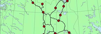
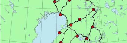
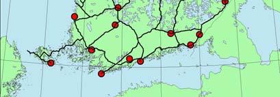
2 The permanent GPS networks FinnRef, FGI 13 stations 4 EPN stations 1 IGS station Recording interval 30 sec GPSNet.fi, Geotrim Ltd. 84 stations ( ) Recording interval 1 sec RTK, VRS and DGPS solutions


3 EUVN_DA activity The number of the accepted EUVN_DA stations is 20. The network is too sparse to fulfill the EUVN_DA requirements. 30 precise levelling benchmarks were selected for GPS densification. The densification stations will be connected to ETRF89 vie FinnRef, but because the distances from the permanent stations are long we will use the data from GPSNet-stations in the solution, in order to strengthen the solution. The final EUVN_DA network consists of 50 stations.


4 Precise Levelling and the new height system The field work of the Third Precise Levelling was completed in The Ministry of Agriculture and Forestry authorized the FGI to set up a working group to propose a new national height system to replace the old one (N60). According to the report given by the working group the Finnish national height system (N60) should be replaced by a new one, which is based on the following main principles: The datum shall coincide with the datum of the European height system. Normal heights shall be adopted. The zero tidal system shall be used. The height difference between the new (N2000) and the old (N60) height system varies from 20 cm to 42 cm.
 RIMS (Ranging")


5 Navigation EGNOS RIMS Station The EGNOS (European Geostationary Navigation Overlay Service) RIMS (Ranging and Integrity Monitoring Station) station at Virolahti, was fully deployed during Virtual DGPS based on EGNOS signal The basic concept is to convert the EGNOS signal to RTCM signals, and broadcast the converted RTCM signals over wireless Internet using Internet Radio technology. Two test cases have been carried out with the prototype system. The test results show that the positioning accuracy of the virtual DGPS solution is about 1-2 meters at 95%,
6 Real-time Data Communication System for FinnRef Developing a new data communication system for the FinnRef has been ongoing since Hourly data is automatically downloaded from 10 stations. The data server automatically sends the data from the EUREF stations, namely Metsähovi, Sodankylä, Vaasa, Joensuu, to the EUREF data processing centres. At the end of 2005, real-time data transfer was accomplished at the Metsähovi station. The real-time is transmitted and handled separately by the Internet broadcaster developed by the FGI.


7 Metrology The FGI is the National Standards Laboratory of acceleration of free fall and length. Gravity National gravity network, Absolute and relative gravity measurements Recording of temporal gravity variations Calibrations Height determination instruments EDM instruments Nummela Standard Baseline The new office and store building and roofed observation pillars were build up in The quartz metre system with interferometrical comparisons in the Tuorla Observatory of University of Turku. (Photo: Pasi Häkli)


8 Instrumentation: Metsähovi Research Station SLR During 2004 a total of 294 orbits of 18 satellites were observed. A new laser system was got as a loan from the SLR station of the Austrian Academy of Sciences at Graz. GPS & GLONASS Station belongs to IGS, EPN and FinnRef networks and takes part to IGLOS project. DORIS The Doris beacon continued its operation. Superconducting gravimeter: Vertical motion due to loading by the atmosphere and by the Baltic Sea were studied using the observations of the superconducting gravimeter Geodetic VLBI The VLBI observations were started in co-operation with the Metsähovi Radio Observatory of the Helsinki University of Technology.
Practical Test on Accuracy and Usability of Virtual Reference Station Method in Finland
 Practical Test on Accuracy and Usability of Virtual Reference Station Method in Finland Pasi HÄKLI, Finland Key words: Real-time kinematic (RTK) GPS, Network RTK, Virtual reference station (VRS) SUMMARY
Future of Reference Frames from Static to Dynamic? Markku Poutanen and Pasi Häkli
 Future of Reference Frames from Static to Dynamic? Markku Poutanen and Pasi Häkli Finnish Geospatial Research Institute, FGI Future of Reference Frames from Static to Dynamic? kinematic Markku Poutanen
From Passive to Active Control Point Networks Evaluation of Accuracy in Static GPS Surveying
 From Passive to Active Control Point Networks Evaluation of Accuracy in Static GPS Surveying P. Häkli 1, U. Kallio 1 and J. Puupponen 2 1) Finnish Geodetic Institute 2) National Land Survey of Finland
Integrated geodetic infrastructure at the Geodetic Observatory Pecný, Czech Republic, in service of national and international GNSS projects
 Integrated geodetic infrastructure at the Geodetic Observatory Pecný, Czech Republic, in service of national and international GNSS projects Pavel NOVÁK, Czech Republic Key words: geodesy, reference systems,
The realization of a 3D Reference System
 The realization of a 3D Reference System Standard techniques: topographic surveying and GNSS Observe angles and distances either between points on the Earth surface or to satellites and stars. Do not observe
OF POLAND TO EUREF 2009
 NATIONAL REPORT OF POLAND TO EUREF 2009 Jan Krynski Institute of Geodesy and Cartography, Warsaw Jerzy B. Rogowski Warsaw University of Technology, Warsaw Outline Main geodetic activities at the national
National Report of Greece to EUREF 2009
 National Report of Greece to EUREF 2009 M. Gianniou KTIMATOLOGIO S.A. (Hellenic Cadastre) 1 Introduction In 2007, KTIMATOLOGIO S.A (Hellenic Cadastre) established HEPOS, the HEllenic POsitioning System,
National Report of Sweden to the EUREF 2006 Symposium
 1 National Report of Sweden to the EUREF 2006 Symposium geodetic activities at Lantmäteriet, the National Land Survey of Sweden L. JIVALL, M. LIDBERG, J ÅGREN, M. LILJE, D NORIN Lantmäteriet, SE-801 82
The 3 rd generation SWEPOS TM network - towards a modern GNSS reference station infrastructure
 The 3 rd generation SWEPOS TM network - towards a modern GNSS reference station infrastructure Lars Jämtnäs, Johan Sunna and Bo Jonsson Johan Sunna, 2010-09-28, Sundvolden hotel Table of contents Introduction
EUREF Permanent GNSS Network Carine Royal Observatory of Belgium
 ENEON first workshop Observing Europe: Networking the Earth Observation Networks in Europe EUREF Permanent GNSS Network Carine Bruyninx/C.Bruyninx@oma.be Royal Observatory of Belgium 1. About your network
PosKEN Related Activities in the Czech Republic
 Research Institute of Geodesy, Topography, and Cartography Geodetic Observatory Pecny Land Survey Office, Prague PosKEN Related Activities in the Czech Republic 2014-2015 National Report J. Šimek 1 and
Trimble GNSS Infrastructure
 Trimble GNSS Infrastructure A History of Innovation Trimble, the first company to offer commercial GPS products company to integrate GPS with communications technology RTK system in the market in 1994
Participants. A (draft) agenda: NKG, Working Group: Positioning and Reference Frame 21 st 22 nd of October 2009, FGI, Masala, Finland
 agenda: NKG, Working Group: Positioning and Reference Frame 21 st 22 nd of October 2009, FGI, Masala, Finland") NKG, Working Group: Positioning and Reference Frame 21 st 22 nd of October 2009, FGI, Masala, Finland Draft version, November 13, 2009 Revised version, December 8, 2009 Participants Denmark: Per Knudsen,
NKG, Working Group: Positioning and Reference Frame 21 st 22 nd of October 2009, FGI, Masala, Finland Draft version, November 13, 2009 Revised version, December 8, 2009 Participants Denmark: Per Knudsen,
EUREF Related Activities in the Czech Republic
 Research Institute of Geodesy, Topography, and Cartography Geodetic Observatory Pecny Land Survey Office, Prague EUREF Related Activities in the Czech Republic 2014-2015 National Report J. Douša 1, V.
Geodetic policy for Ireland and Northern Ireland
 Geodetic policy for Ireland and Northern Ireland Background Ordnance Survey Ireland (OSi) is the National Mapping Agency (NMA) of the Republic of Ireland. The Ordnance Survey of Northern Ireland (OSNI)
Utilizing A GNSS Network Solution for Utility Applications
 Utilizing A GNSS Network Solution for Utility Applications David Newcomer, PE, PLS GPServ, Inc. newcomer@ (407) 601-5816 AGENDA Types and accuracies of data collection o Autonomous o Meter + o Sub-meter
What makes the positioning infrastructure work. Simon Kwok Chairman, Land Surveying Division Hong Kong Institute of Surveyors
 What makes the positioning infrastructure work The experience of the Hong Kong Satellite Positioning Reference Station Network Simon Kwok Chairman, Land Surveying Division Hong Kong Institute of Surveyors
Comparative analysis of GNSS Real Time Kinematic methods for navigation
 IAV Hassan II Comparative analysis of GNSS Real Time Kinematic methods for navigation Mourad BOUZIANI School of Geomatic Sciences, IAV Hassan II, Rabat, Morocco. Coordinator of the Master - GNSS, IAV&
FieldGenius Technical Notes GPS Terminology
 FieldGenius Technical Notes GPS Terminology Almanac A set of Keplerian orbital parameters which allow the satellite positions to be predicted into the future. Ambiguity An integer value of the number of
NORDISKA KOMMISSIONEN FÖR GEODESI
 NORDISKA KOMMISSIONEN FÖR GEODESI Ordförande BJøRN ENGEN Statens Kartverk Kartverksvn 21 N-3500 Hønefoss NORGE Sekreterare BO JONSSON Lantmäteriverket LF-Geodesi SE-801 82 Gävle SVERIGE The NKG Steering
The International Scene: How Precise Positioning Will Underpin Critical GNSS Applications
 The International Scene: How Precise Positioning Will Underpin Critical GNSS Applications School of Civil & Environmental Engineering, UNSW, Sydney, Australia Chris Rizos Member of the IGS Governing Board
EUREF Related Activities
 Symposium of the IAG Subcommission for Europe (EUREF) Chisinau, Moldova, 25 28 May, 2011 National Report of the Czech Republic EUREF Related Activities in the Czech Republic 2010-2011 National Report presented
ROMPOS FOR CADASTRE APPLICATIONS
 International Symposium on Global Navigation Satellite Systems, Space-Based and Ground-Based Augmentation Systems and Applications 2009; Berlin, Germany, 30 November - 2 December 2009 ROMPOS FOR CADASTRE
New Tools for Network RTK Integrity Monitoring
 New Tools for Network RTK Integrity Monitoring Xiaoming Chen, Herbert Landau, Ulrich Vollath Trimble Terrasat GmbH BIOGRAPHY Dr. Xiaoming Chen is a software engineer at Trimble Terrasat. He holds a PhD
Towards a EUREF Service Providing Real-time GNSS Clock and Orbit Corrections
 Towards a EUREF Service Providing Real-time GNSS Clock and Orbit Corrections G. Weber 1), W. Söhne 1), A. Stürze 1), L. Mervart 2) 1) Federal Agency for Cartography and Geodesy, Frankfurt am Main, Germany
Proposed standard for permanent GNSS reference stations in the Nordic countries
 Version 0.6 2003-05-15 Proposed standard for permanent GNSS reference stations in the Nordic countries Introduction Subproject A0 of the project Nordic Real-time Positioning Service Gunnar Hedling, Finn
EUPOS European Position Determination System
 EUPOS European Position Determination System c/o Senate Department for Urban Development, State Berlin, Germany Umea, Sweden, 22 nd 23 rd 2011 The Geodetic Infrastructure in Europe today and tomorrow Slide
EUREF Related Activities in the Czech Republic
 Research Institute of Geodesy, Topography, and Cartography Geodetic Observatory Pecny Land Survey Office, Prague EUREF Related Activities in the Czech Republic 2015-2016 National Report J. Douša 1, V.
GEODETIC AND NON GEODETIC APPLICATIONS PERFORMED BY WUT LAC
 WARSAW UNIWERSITY OF TECHNOLOGY Institute of Geodesy and Geodetic Astronomy Pl. Politechniki 1, 00-661 Warsaw, Poland igga@gik.pw.edu.pl, phone (+48 22) 622-85-15 Mariusz Figurski, Lech Kujawa GEODETIC
National Report of Greece to EUREF 2010
 National Report of Greece to EUREF 2010 M. Gianniou KTIMATOLOGIO S.A. (Hellenic Cadastre) 1 Introduction The HEllenic POsitioning System (HEPOS) is an RTK network consisting of 98 reference stations that
TrigNet, South Africa s GNSS base station network: past, present and future
 TrigNet, South Africa s GNSS base station network: past, present and future Patrick Vorster 1, Stephan Koch 2 Chief Directorate: National Geospatial Information. Department of Rural Development and Land
IMO WORLDWIDE RADIONAVIGATION SYSTEM (WWRNS) Study on Communication Techniques for High Accuracy DGPS in the Republic of Korea
 Study on Communication Techniques for High Accuracy DGPS in the Republic of Korea") INTERNATIONAL MARITIME ORGANIZATION E IMO SUB-COMMITTEE ON SAFETY OF NAVIGATION 52nd session Agenda item 12 NAV 52/INF.8 12 May 2006 ENGLISH ONLY WORLDWIDE RADIONAVIGATION SYSTEM (WWRNS) Study on Communication
INTERNATIONAL MARITIME ORGANIZATION E IMO SUB-COMMITTEE ON SAFETY OF NAVIGATION 52nd session Agenda item 12 NAV 52/INF.8 12 May 2006 ENGLISH ONLY WORLDWIDE RADIONAVIGATION SYSTEM (WWRNS) Study on Communication
SSR Technology for Scalable Real-Time GNSS Applications
 SSR Technology for Scalable Real-Time GNSS Applications Gerhard Wübbena, Jannes Wübbena, Temmo Wübbena, Martin Schmitz Geo++ GmbH 30827 Garbsen, Germany www.geopp.de Abstract SSR Technology for scalable
EUREF Related Activities in the Czech Republic
 Research Institute of Geodesy, Topography, and Cartography Geodetic Observatory Pecny Land Survey Office, Prague EUREF Related Activities in the Czech Republic 2012-2013 National Report J. Šimek 1, J.
Status and plans for reference networks and systems in Denmark The Geodetic Infrastructure in Europe Umeå - Sweden, June 22-23, 2011
 Status and plans for reference networks and systems in Denmark The Geodetic Infrastructure in Europe Umeå - Sweden, June 22-23, 2011 Mette Weber and Lola Bahl National Survey and Cadastre - Denmark Content
GPS and GNSS from the International Geosciences Perspective
 GPS and GNSS from the International Geosciences Perspective G. Beutler Astronomical Institute, University of Bern Member of IAG Executive Committee and of IGS Governing Board National Space-Based Positioning,
NORDISKA KOMMISSIONEN FÖR GEODESI
 Chairman NIELS ANDERSEN DTU Space National Space Institute Elektrovej Building 327 DK-2826 Kgs. Lyngby Danmark Secretary MIKAEL LILJE Lantmäteriet Geodesienheten SE-801 82 GÄVLE SVERIGE Time: 25-26 November,
NTRIP Background History, Development & BKG. Networked Transport of RTCM via Internet Protocol
 Networked Transport of RTCM via Internet Protocol Networked Transport of RTCM via Internet Protocol Bundesamt für Kartographie und Geodäsie Motivation: Use Internet to transport GNSS corrections Communication
TrigNet: The South African Network of Continuously Operating GNSS Base Stations
 TrigNet: The South African Network of Continuously Operating GNSS Base Stations R Wonnacott ESESA User Need Workshop Thread 2: Status of Current GNSS Applications in South Africa Somerset West 2 March
EUREF Related Activities in the Czech Republic
 Research Institute of Geodesy, Topography, and Cartography Geodetic Observatory Pecny Land Survey Office, Prague EUREF Related Activities in the Czech Republic 2011-2012 National Report J. Šimek1, J. Douša1,
Geodetic Reference Frame Theory
 Technical Seminar Reference Frame in Practice, Geodetic Reference Frame Theory and the practical benefits of data sharing Geoffrey Blewitt University of Nevada, Reno, USA http://geodesy.unr.edu Sponsors:
NGOs, the Nordic Geodetic Observing System
 NGOs, the Nordic Geodetic Observing System Mikael LILJE Sweden, Markku POUTANEN, Finland, Per KNUDSEN, Denmark, Hans-Georg SCHERNECK, Sweden, Ingunn SKEI and Svein Ola THORSEN, Norway Key words: geodetic
Precise Positioning... what does it mean? Precise GNSS Positioning Not just a niche technology. Chris Rizos 15/12/15
 Precise GNSS Positioning Not just a niche technology Chris Rizos Precise Positioning... what does it mean? 1 Precise Positioning... a spectrum of users... Few mm 1cm 2cm < dm 1dm sub-m Precision agriculture
Indian Institute of Technology Kanpur Department of Civil Engineering
 Indian Institute of Technology Kanpur Department of Civil Engineering Inquiry No- CE/JNM/2013-14/R-10 30 December, 2013 Subject: Quotation for supply of Integrated System/Smart System Reflectorless Robotic
Indoor Navigation and the. Conferest Demo App
 Indoor Navigation and the Presented at the FIG Working Week 2017, May 29 - June 2, 2017 in Helsinki, Finland Conferest Demo App Dept. of Navigation and Positioning Finnish Geospatial Research Institute
Implementation of New Positioning System in Riga
 Implementation of New Positioning System in Riga M.Abele (1), J.Balodis (1), K.Balodis (1), M.Caunite (1), I.Janpaule (1), A.Rubans (1), G.Silabriedis (1,2), I.Mitrofanovs(2), A.arinsjh (1) (1) University
Philippine Geodetic Infrastructure Status, Challenges and Future Direction
 Philippine Geodetic Infrastructure Status, Challenges and Future Direction Engr. Charisma Victoria D. Cayapan National Mapping and Resource Information Authority PHILIPPINES Outline Evolution of Geodetic
IAG School on Reference Systems June 7 June 12, 2010 Aegean University, Department of Geography Mytilene, Lesvos Island, Greece SCHOOL PROGRAM
 IAG School on Reference Systems June 7 June 12, 2010 Aegean University, Department of Geography Mytilene, Lesvos Island, Greece SCHOOL PROGRAM Monday June 7 8:00-9:00 Registration 9:00-10:00 Opening Session
The Reasons to Succeed or to Fail a GNSS Network RTK Project
 The Reasons to Succeed or to Fail a GNSS Network RTK Project Joël van Cranenbroeck, Managing Director CGEOS Creative Geosensing sprl-s, Belgium Andy Yin, International Sales Director ComNav Technology
National Report of Sweden to the EUREF 2012 Symposium
 National Report of Sweden to the EUREF 2012 Symposium geodetic activities at Lantmäteriet L. JIVALL, L. E. ENGBERG, M. LIDBERG, A. ENGFELDT, P. WIKLUND, D. NORIN, J. ÅGREN, M. LILJE Lantmäteriet, SE-801
Cross-Border EUPOS Data Exchange First Experience
 Cross-Border EUPOS Data Exchange First Experience Eimuntas Paršeliūnas, Marius Petniūnas, Domantas Bručas (Institute of Geodesy of Vilnius Gediminas Technical University, Lithuania) Wieslaw Graszka (Head
GPS Geodetic Reference System WGS 84
 GPS Geodetic Reference System WGS 84 International Committee on GNSS Working Group D Saint Petersburg, Russia 16 September 2009 Barbara Wiley National Geospatial-Intelligence Agency United States of America
Satellite Navigation Using GPS
 Satellite Navigation Using GPS T.J. Martín Mur & J.M. Dow Orbit Attitude Division, European Space Operations Centre (ESOC), Darmstadt, Germany Introduction The launch of the first Sputnik triggered the
08/10/2013. Marine Positioning Systems Surface and Underwater Positioning. egm502 seafloor mapping
 egm502 seafloor mapping lecture 8 navigation and positioning Marine Positioning Systems Surface and Underwater Positioning All observations at sea need to be related to a geographical position. To precisely
Positioning, location data and GNSS as solution for Autonomous driving
 Positioning, location data and GNSS as solution for Autonomous driving Jarkko Koskinen, Heidi Kuusniemi, Juha Hyyppä, Sarang Thombre and Martti Kirkko-Jaakkola FGI, NLS Definition of the Arctic 66 34 N
FIELD TEST OF THE GPS+GLONASS RTK AT THE CAGLIARI PERMANENT STATION VIA INTERNET. Giannina Sanna, Giuseppina Vacca
 FIELD TEST OF THE GPS+GLONASS RTK AT THE CAGLIARI PERMANENT STATION VIA INTERNET Giannina Sanna, Giuseppina Vacca University of Cagliari Department of Structural Engineering P.zza D Armi 913 Cagliari,
National Report of Austria
 National Report of Austria EUREF 05 Vienna 1.6-3.6. 2005 Ernst Zahn - BEV Vienna ISR - Space Research Institute / Austrian Academy of Sciences - Österreichische Akademie der Wissenschaften (ÖAW) BEV -
SWEREF 99 - an Updated EUREF Realisation for Sweden
 EUREF Reference Frame 167 SWEREF 99 - an Updated EUREF Realisation for Sweden L. JIVALL 1, M. LIDBERG 1 1. Abstract SWEREF 99 will replace SWEREF 93, which has been used as the Swedish EUREF realisation
Applications, Products and Services of GPS Technology
 Applications, Products and Services of GPS Technology Enrico C. Paringit. Dr. Eng. University of the Philippines Training Center for Applied Geodesy and Photogrammetry 1 Outline of this Presentation GPS
NATIONAL REPORT OF POLAND TO EUREF 2012
 NATIONAL REPORT OF POLAND TO EUREF 2012 Jan Krynski Institute of Geodesy and Cartography, Warsaw Jerzy B. Rogowski Warsaw University of Technology, Warsaw Outline Main geodetic activities at the national
European Position Determination System (EUPOS )
") European Position Determination System (EUPOS ) Georgi MILEV, Bulgaria, Gerd ROSENTHAL, Germany and Keranka VASSILEVA, Bulgaria Key words: ABSTRACT The project EUPOS is an initiative to establish a uniform
European Position Determination System (EUPOS ) Georgi MILEV, Bulgaria, Gerd ROSENTHAL, Germany and Keranka VASSILEVA, Bulgaria Key words: ABSTRACT The project EUPOS is an initiative to establish a uniform
Chapter 6 GPS Relative Positioning Determination Concepts
 Chapter 6 GPS Relative Positioning Determination Concepts 6-1. General Absolute positioning, as discussed earlier, will not provide the accuracies needed for most USACE control projects due to existing
National Report of Sweden to the EUREF 2011 Symposium
 National Report of Sweden to the EUREF 2011 Symposium geodetic activities at Lantmäteriet L. E. ENGBERG, L. JIVALL, M. LIDBERG, A. ENGFELDT, P.-O. ERIKSSON, B. JONSSON, M. LILJE, D. NORIN, J. ÅGREN Lantmäteriet,
Some Metrological Issues of GNSS Positioning: Case Study for the Czech Republic
 Some Metrological Issues of GNSS Positioning: Case Study for the Czech Republic Jaroslav Šimek Research Institute of Geodesy, Topography and Cartography - Geodetic Observatory Pecný The research is supported
DYNAMIC RT TECHNOLOGY
 DYNAMIC RT TECHNOLOGY GLOBAL NAVIGATION SATELLITE SYSTEMS (GNSS) POTENTIAL FUTURE DEVELOPMENTS(2005 2017?) GPS MODERNIZATION BLOCK IIF & III GLONASS ENHANCEMENTS (K & M) EUROPEAN UNION - GALILEO CHINA
GNSS & Coordinate Systems
 GNSS & Coordinate Systems Matthew McAdam, Marcelo Santos University of New Brunswick, Department of Geodesy and Geomatics Engineering, Fredericton, NB May 29, 2012 Santos, 2004 msantos@unb.ca 1 GNSS GNSS
Other Space Geodetic Techniques. E. Calais Purdue University - EAS Department Civil 3273
 Other Space Geodetic Techniques E. Calais Purdue University - EAS Department Civil 3273 ecalais@purdue.edu Satellite Laser Ranging = SLR Measurement of distance (=range) between a ground station and a
GUIDELINES FOR EPN STATIONS & OPERATIONAL CENTRES
 Guidelines for EPN Stations & Operational Centres Page 1 of 16 GUIDELINES FOR EPN STATIONS & OPERATIONAL CENTRES EPN Central Bureau C. Bruyninx, epncb@oma.be Updates: Regional data centre OLG is replaced
Other Space Geodetic Techniques. E. Calais Purdue University - EAS Department Civil 3273
 Other Space Geodetic Techniques E. Calais Purdue University - EAS Department Civil 3273 ecalais@purdue.edu Satellite Laser Ranging Measurement of distance (=range) between a ground station and a satellite
AN AUSTRALIAN PILOT PROJECT FOR A REAL TIME KINEMATIC GPS NETWORK USING THE VIRTUAL REFERENCE STATION CONCEPT
 AN AUSTRALIAN PILOT PROJECT FOR A REAL TIME KINEMATIC GPS NETWORK USING THE VIRTUAL REFERENCE STATION CONCEPT Matthew B HIGGINS, Australia Key words: GPS, Surveying, Real Time Kinematic, Virtual Reference
A Permanent GPS Array in Crete & the Cal/Val facility for satellite radar altimeters in Gavdos
 A Permanent GPS Array in Crete & the Cal/Val facility for satellite radar altimeters in Gavdos S. P. Mertikas Technical University f Crete EUREF 2007 Symposium, 6-96 9 June 2007, London, England Laboratory
Local Control Network of the Fiducial GLONASS/GPS Station
 Related Contributions 333 Local Control Network of the Fiducial GLONASS/GPS Station V.I. KAFTAN, R.A. TATEVIAN 1 Abstract The controlling geodetic network for the Moscow station of the Fiducial Astro-Geodetic
The role of EGNOS in the recapitalised DGNSS service of WSV - concept and implementation
 The role of EGNOS in the recapitalised DGNSS service of WSV - concept and implementation Tamás Horváth 1, Michael Hoppe 2 1 Alberding GmbH 2 German Federal Waterways and Shipping Administration (WSV) EGNOS
Contributions of Onsala Space Observatory to GGOS
 Contributions of Onsala Space Observatory to GGOS R. Haas, G. Elgered, T. Hobiger, H.-G. Scherneck, J. Johansson Abstract The Onsala Space Observatory (OSO) on the Swedish west coast is the fundamental
R E P O R T. of the BSHC Working Group for the Harmonization of the Chart Datum of the Baltic Sea (CDWG)
") 12-14 June 2007 Explanatory Note Klaipeda, Lithuania R E P O R T of the BSHC Working Group for the Harmonization of the Chart Datum of the Baltic Sea (CDWG) Activities of the CDWG The CDWG was established
12-14 June 2007 Explanatory Note Klaipeda, Lithuania R E P O R T of the BSHC Working Group for the Harmonization of the Chart Datum of the Baltic Sea (CDWG) Activities of the CDWG The CDWG was established
The Kingdom Of Saudi Arabia GNSS Real Time Kinematic Network (MRTN) And Beyond (A Case Study for High Accuracy VRS Correction Test)
 And Beyond (A Case Study for High Accuracy VRS Correction Test)") The Kingdom Of Saudi Arabia GNSS Real Time Kinematic Network (MRTN) And Beyond (A Case Study for High Accuracy VRS Correction Test) Ali ALOMAR, Saudi Arabia, Dr. Ramazan YANAR Turkey, Sami ALBALAWI, Saeed
The Kingdom Of Saudi Arabia GNSS Real Time Kinematic Network (MRTN) And Beyond (A Case Study for High Accuracy VRS Correction Test) Ali ALOMAR, Saudi Arabia, Dr. Ramazan YANAR Turkey, Sami ALBALAWI, Saeed
METIS Second Master Training & Seminar. Augmentation Systems Available in Egypt
 METIS Second Master Training & Seminar Augmentation Systems Available in Egypt By Eng. Ramadan Salem M. Sc. Surveying and Geodesy Email: ramadan_salem@link.net Page 1 Augmentation Systems Available in
Trimble GPSNet 2.5 Software for GNSS Infrastructure: New Features. Martin Janousek - Trimble Technical Support - Infrastructure
 Trimble GPSNet 2.5 Software for GNSS Infrastructure: New Features Martin Janousek - Trimble Technical Support - Infrastructure GPSNet Users Seminar Munich, March 30 th /31 th 2006 Overview Support for
Global Correction Services for GNSS
 Global Correction Services for GNSS Hemisphere GNSS Whitepaper September 5, 2015 Overview Since the early days of GPS, new industries emerged while existing industries evolved to use position data in real-time.
Optics and optical instruments Field procedures for testing geodetic and surveying instruments. Part 8:
 Provläsningsexemplar / Preview INTERNATIONAL STANDARD ISO 17123-8 Second edition 2015-06-15 Optics and optical instruments Field procedures for testing geodetic and surveying instruments Part 8: GNSS field
Drive-by DTM. and Navigation at our university in cooperation
 Drive-by DTM GPS and GSM/GPRS Power Cost-Effective Terrain Modeling A data teletransmission system for quick and efficient creation of digital terrain models (DTMs) forms the backbone of experimental work
EUPOS - EUROPEAN POSITION DETERMINATION SYSTEM INITIATIVE
 EUPOS - EUROPEAN POSITION DETERMINATION SYSTEM INITIATIVE Dr. Branislav Droščák EUPOS chairman & Geodetic and Cartographic institute Bratislava CLGE General Assembly March 22.-23. 2019. Sofia, Bulgaria
Facilities: Lab facilities of the Department Geoscience and Remote Sensing
 Lab facilities GRS Lab facilities of the Department Geoscience and Remote Sensing The department has a wide variety of lab facilities. The lab facilities within the building of CEG is rather limited. We
SKPOS. Slovak real-time positioning service - a multifunctional tool for precise object and phenomena positioning
 SKPOS Slovak real-time positioning service - a multifunctional tool for precise object and phenomena positioning WHAT IS SKPOS AND HOW DOES IT WORK? Slovak real-time positioning service is a multifunctional
National Report of Sweden to the EUREF 2010 Symposium
 National Report of Sweden to the EUREF 2010 Symposium geodetic activities at Lantmäteriet L. E. ENGBERG, L. JIVALL, M. LIDBERG, A. ENGFELDT, P.-O. ERIKSSON, B. JONSSON, M. LILJE, D. NORIN, J. ÅGREN Lantmäteriet,
GNSS Accuracy Improvements through Multipath Mitigation with New Signals and services
 GNSS Accuracy Improvements through Multipath Mitigation with New Signals and services Andrey Veytsel, Ph.D Moscow Technical University 10 Meeting of the International Committee on Global Navigation Satellite
Guidelines for EUREF Densifications
 Guidelines for EUREF Densifications Carine Bruyninx, ROB EUREF Tutorial May 24, 2016 San Sebastian, Spain EPN CB: www.epncb.oma.be ftp://epncb.oma.be/pub/general/guidelines_ for_euref_densifications.pdf
al T TD ) ime D Faamily Products The RTD Family of products offers a full suite of highprecision GPS sensor positioning and navigation solutions for:
 ime D Faamily Products The RTD Family of products offers a full suite of highprecision GPS sensor positioning and navigation solutions for:") Reeal ynnamics al T amics (R TD ) ime D RTD) Time Dy Faamily mily ooff P roducts Products The RTD Family of products offers a full suite of highprecision GPS sensor positioning and navigation solutions
Reeal ynnamics al T amics (R TD ) ime D RTD) Time Dy Faamily mily ooff P roducts Products The RTD Family of products offers a full suite of highprecision GPS sensor positioning and navigation solutions
LitPOS a part of EUPOS
 Project part-financed by the European Union LitPOS a part of EUPOS Eimuntas Parseliunas 1, Arunas Buga 1, Leonardas Marozas 1, Marius Petniunas 1, Saulius Urbanas 2 Abstract 1 Institute of Geodesy, Vilnius
EXPERIMENTAL RESULTS OF LEX CORRECTIONS USING FARMING MACHINE
 Sixth Meeting of the International Committee on Global Navigation Satellite Systems (ICG) EXPERIMENTAL RESULTS OF LEX CORRECTIONS USING FARMING MACHINE Masayuki Kanzaki Hitachi Zosen Corporation Prof.
NYSNET 11/28/2014 GPS/GLONASS (GG) January 2015 NYSAPLS Conference
 January 2015 NYSAPLS Conference") GPS/GLONASS (GG) January 2015 NYSAPLS Conference 2015 1 NYSNet 2015 GLONASS Upgrades Antenna Types Single Base/Network RTK GPS/GLONASS (GG) Single Base GPS/GLONASS (GG) Network RTK RT Products (NTRIP Mount
GPS/GLONASS (GG) January 2015 NYSAPLS Conference 2015 1 NYSNet 2015 GLONASS Upgrades Antenna Types Single Base/Network RTK GPS/GLONASS (GG) Single Base GPS/GLONASS (GG) Network RTK RT Products (NTRIP Mount
Experiences with Fugro's Real Time GPS/GLONASS Orbit/Clock Decimeter Level Precise Positioning System
 Return to Session Directory DYNAMIC POSITIONING CONFERENCE October 13-14, 2009 Sensors Experiences with Fugro's Real Time GPS/GLONASS Orbit/Clock Decimeter Level Precise Positioning System Ole Ørpen and
Accuracy Evaluation Internet-Based GNSS for Kinematic Surveying the Case Study in Thailand
 Accuracy Evaluation Internet-Based GNSS for Kinematic Surveying the Case Study in Thailand Kritsada Anantakarn 1 1 Faculty of Engineering and Architectural : Uthenthawai campus. Rajamongala University
GPS: The Basics. Darrell R. Dean, Jr. Civil and Environmental Engineering West Virginia University. Expected Learning Outcomes for GPS
 GPS: The Basics Darrell R. Dean, Jr. Civil and Environmental Engineering West Virginia University Expected Learning Outcomes for GPS Explain the acronym GPS Name 3 important tdt dates in history of GPS
Future GNSS Precision Applications. Stuart Riley
 Future GNSS Precision Applications Stuart Riley Major Trimble Precision Markets Survey Mostly person portable equipment Construction Machine control and person carried equipment Includes Marine applications
Some experiences of Network-RTK in the SWEPOS network
 75 Some experiences of Network-RTK in the SWEPOS network B. JONSSON, G. HEDLING, P. WIKLUND 1 Abstract SWEPOS, the Swedish network of permanent reference stations, is in operation since 1998 and provides
Differential GPS Positioning over Internet
 Abstract Differential GPS Positioning over Internet Y. GAO AND Z. LIU Department of Geomatics Engineering The University of Calgary 2500 University Drive N.W. Calgary, Alberta, Canada T2N 1N4 Email: gao@geomatics.ucalgary.ca
A Differential Reference Station Algorithm For Modular Decentralized GPS/GNSS Master Station Architecture. Oct. 28, 2010
 212-1-29 International Symposium on GPS/GNSS 21 Oct. 26-28, National Cheng Kung Univ., Taiwan A Differential Reference Station Algorithm For Modular Decentralized GPS/GNSS Master Station Architecture Oct.
European Position Determination System. Technical Standards
 European Position Determination System Technical Standards Revised 2 nd Edition 24 April 2008 Resolution of the International EUPOS Steering Committee 13 th Conference, Bucharest, Romania, 23 24 April
Procedures for Quality Control of GNSS Surveying Results Based on Network RTK Corrections.
 Procedures for Quality Control of GNSS Surveying Results Based on Network RTK Corrections. Limin WU, China Feng xia LI, China Joël VAN CRANENBROECK, Switzerland Key words : GNSS Rover RTK operations, GNSS