EUREF Related Activities in the Czech Republic
|
|
|
- Philippa Washington
- 5 years ago
- Views:
Transcription


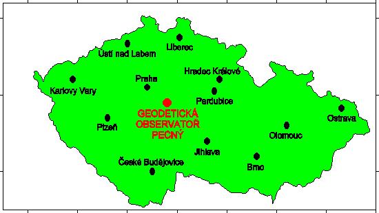
1 Research Institute of Geodesy, Topography, and Cartography Geodetic Observatory Pecny Land Survey Office, Prague EUREF Related Activities in the Czech Republic National Report J. Šimek 1, J. Douša 1, V. Filler 1, J. Kostelecký jr. 1, J. Kostelecký 1, V. Pálinkáš 1, P. Václavovic 1 M. Lederer 2, J. Nágl 2, J. Řezníček 2 1 Research Institute of Geodesy, Topography and Cartography 2 Land Survey Office, Prague Symposium of the IAG Subcommission for Europe EUREF 2013 Budapest, Hungary, May 2013
2 National reference system: S-JTSK/05 Conversion between ETRS89 based user system S-JTSK/05 and mandatory S-JTSK by means of correction tables computed for 2 x 2 km grid; amended tables for border zones in 2012 rms difference 2 cm New conversion tables table_yx_3_v1202.dat implemented into the transformation service of the Geoportal CUZK Conversion of heights by the CR 2005 quasigeoid model (1 x 1.5 grid fitted to 1,024 GPS/levelling heights)
3 Geodetic control networks Czech Republic 78,864 km 2 73,281 triangulation points 34,245 associated points 1313 levelling lines 24,700 km 119,527 levelling benchmarks 460 gravity control stations
4 Database of control point fields Improvements of application software Updating with respect to periodic and dynamic maintenance Data flow between Information System of Surveying, Mapping and Cadastre and the DB and between DB and Information System of State Map work and Fundamental geographical Database

5 Maintenance of horizontal geodetic control point field
6 Permanent GNSS Stations and Networks in the Czech Republic Fundamental Geodetic Observatory Pecný GOPE, (IGS, EPN, CZEPOS, VESOG, E-GVAP II) CZEPOS: Czech Positioning System, 28 PS, operated by the Land Survey Office + 27 PS of neighbour countries GEONAS: 19 PS, experimental monitoring network operated by the Institute of Rock Structure and Mechanics, Acad. Sci. CR VESOG: research and experimental GNSS network operated by the RIGTC GOP and academic institutions, 8 PS TopNet: 23 PS, includes also 11 GEONAS and 3 VESOG PS, operated by the private company GEODIS Brno Trimble VRS NOW Czech: 24 sites + 8 sites of Trimble VRS NOW Deutschland, operated by Geotronics Praha, s.r.o. private company several smaller networks, operated by private companies, e.g. bys@t and others Total: 98 permanent stations, 12 of them EPN
7 Permanent GNSS stations and networks in the Czech Republic
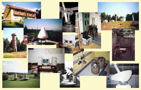
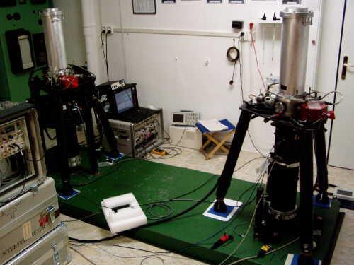
8 Fundamental Geodetic Observatory Pecný (GOPE) RIGTC at Ondřejov
9 GOPE Fundamental GNSS Station Established in 1993, since 1995 has been contributing to IGS (International GNSS Service) Topcon Net-G3 receiver, Topcon CR-G3 antenna with a spherical radom TPSH, individual PC calibration Tracking the following GNSS: GPS NAVSTAR (L1C, L1P, L2P, L2C), GLONASS (L1C, L2P) Post-processing data + real-time data Post-processing data downloaded in RINEX 2.10 format in daily files with 30 sec sampling rate, hourly files/ 1 and 30 sec, 15-min files/ 1 sec Data are forwarded to the following data centers: - GOP - RIGTC, Czech Republic (hourly and daily 30 sec data) - BKG, Frankfurt am Main, Germany (hourly and daily 30 sec data) - OLG, Graz, Austria (hourly and daily 30 sec data) - CZEPOS, Land Survey Office, Czech Republic (hourly 1 sec data) - CDDIS, NASA, U.S.A. (15-minute 1 sec data) Real-time RTCM 2.3 and RTCM 3 data streams forwarded in NTRIP protocol to VESOG caster and further to BKG and CZEPOS casters


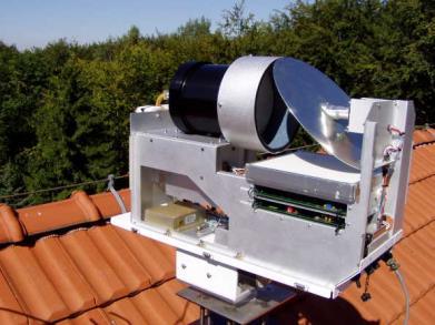
10 Permanent GNSS station GOPE Topcon CR-G3 antenna with TPSH radom Topcon Net-G3 receiver
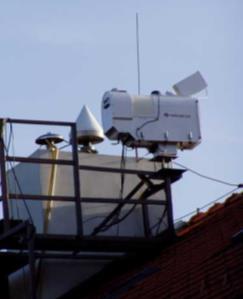
11 GOPE Participation in the M-GEX IGS project station GOP6 excentric site of the main GOPE station in the Multi-GNSS Experiment Leica GRX1200+GNSS receiver + Leica AR25.R4 antenna with a spherical radom LEIT and individual PC calibrations Satellite tracking: GPS NAVSTAR (L1C, L1P, L2P, L2C, L5), GLONASS (L1C, L2P), Galileo (E1, E5a, E5b, AltBoc), SBAS (L1) Post-processing data in RINEX 2.10 (directly generated by the receiver) and RINEX 3.01 (conversion from 2.11 using own software in the operation centre): - hourly and daily files/ 30 sec data - 15 min files of 1 sec data Post-processing data forwarded to: - CDDIS, NASA, USA (only RINEX 3.01) - BKG, Frankfurt am Main, Germany (only RINEX 3.01) - IGN, Paris, France(RINEX 2.10 and 3.01) - GOP, RIGTC, Czech Republic (only RINEX 2.10) Real-time data streams - binary data Leica LB2 - RTCM 2.3 a RTCM 3 - NTRIP protocol forwarded to NTRIPcaster VESOG/GOP, RIGTC, Czech Republic, binary data LB2 forwarded to the M-GEX caster of the BKG, Frankfurt/Main, Germany


12 GOP6 M-GEX Site - antenna
13 GOPE Participation in the JAXA MGM Project MGM (Multi-GNSS Monitoring network) Project organized by the Japan Aerospace Agency JAXA GOPE participates as a hosting station operating a receiver provided on loan by JAXA Javad DELTA-G3T receiver is connected through a signal splitter to the Leica AR25.R4 antenna with a spherical radom LEIT installed at the GOP6 site Satellite tracking: - GPS NAVSTAR (L1C, L1P, L2P, L2C, L5) - GLONASS (L1C, L1P, L2P, L2C) - Galileo (E1, E5) - SBAS (L1, L5) including the first QZSS satellite Real-time data forwarded to the NTRIP caster of the MGM project in Japan as Javad binary data Providing post-processing data generated by the Javad receiver for the M-GEX project under negotiations


14 GOPE - receivers Leica GRX1200+GNSS receiver at GOP6 Javad DELTA-G3T receiver at GOP7/GOP6M


15 CZEPOS operated by Land Survey Office since 2004/2005
 / 1 hour, DGPS = 20 Kč (0,82 ) / 1 hour Post-processing: data interval 1 4 sec = 80 Kč (3.26 ), 5 9 sec = 16 Kč (0.65 ), 10 19 sec = 8 Kč (0.33 ), 20 sec = 4 Kč (0.")
16 CZEPOS Services DGPS RTK VRS DGPS RTK RTK3-NS RTK3-GG RTK-PRS RTK-FKP VRS3-MAX, VRS3-iMAX VRS3-MAX-GG, VRS3- imax-gg Real-time services: RTK, RTK-FKP, RTK- PRS, RTK3, VRS3 = 80 Kč (3,26 ) / 1 hour, DGPS = 20 Kč (0,82 ) / 1 hour Post-processing: data interval 1 4 sec = 80 Kč (3.26 ), 5 9 sec = 16 Kč (0.65 ), sec = 8 Kč (0.33 ), 20 sec = 4 Kč (0.16 )

17 CZEPOS availability of services

18 CZEPOS number of users
19 Analysis and Research EPN Data Center GOP EPN Analysis Center GOP IGS rapid orbits Monitoring of permanent GNSS sites GNSS-based international projects Geodynamics EPN velocities, CEGRN IDS Analysis Center GOP
 EUREF, IGS, VESOG, CZEPOS, GOP Data Centre (EUREF,.")

20 GNSS data operation/dissemination GOP operational centre GPS, GLONASS, Galileo, QZSS hourly, daily, real-time 30-sec, high-rate (1Hz) EUREF, IGS, VESOG, CZEPOS, GOP Data Centre (EUREF,..) Files GNSS data (daily, hourly and historical), various supporting products and information Real-time streams NTRIP caster data/product file latency monitoring real-time data content monitoring 20
 product: 2-day arcs fitting, 1-day arc prediction usage: (near)")

21 GPS+GLONASS precise orbit determination GOP contribution to the International GNSS Service (IGS) since 2004 software: Bernese GPS sw. V5.2 input: hourly GPS data + navigation messages output: ultra-rapid orbits (GPS+GLONASS) product: 2-day arcs fitting, 1-day arc prediction usage: (near) real-time applications processing features: LSQ adjustment 6-hour update cycle double-differenced observations efficient strategy with no redundancy network split into continental clusters self-initializing processing system all satellites included, multi-gnss automated manoeuvres detection originally developed at GOP
 since 2004 orbits clocks Y,X pole X,Y pole rates length")

 new system introduced (2006) orbit model improved (2007)")
22 GOP orbits/erp products (milestones) GOP contribution to the International GNSS Service (IGS) since 2004 orbits clocks Y,X pole X,Y pole rates length of the day fitted prod. predicted prod. <5 cm 10 cm mas 0.3 mas 0.2 mas/day 0.3 mas/day 0.03 ns 0.07 ns 1 st official GOP GPS contribution (2004) contribution discontinued (2006) new system introduced (2006) orbit model improved (2007) GPS+GLONASS solution (2010) improved accuracy code (2009)


23 GOP sub-network re-processing ( ) Consistent upto-date models applied A long-term homogeneous solution Coordinate timeseries for geodynamics and reference frame Troposphere parameters time-series for climate studies 23
24 G-Nut software development Program package for various end-user applications kinematic position, monitoring long-term coordinate time series, ZTD estimation, satellite clocks etc. C ++ language, object oriented concept RT and post-processing modes Integration of all available GNSS, new signals Applications developed in 2013: Anubis, Geb, Tefnut Anubis: checking, editing, converting and concatenating GNSS observation and navigation files Geb and Tefnut: PPP-based processing of undifferenced phase and code observations (offline and RT modes at GOP AC)
25 GOP participation in international projects GPS-ground based meteorology E-GVAP II, GNSS4SWEC COST ES1206 EPOS - WG4, VESOG network EUPOS contribution to ECC CEGRN Consortium MoU between CEGRN and EUREF ESA
26 GOP in COST ES 1206 GNSS4SWEC NRT/RT processing (ultra-fast/real-time, multi GNSS, troposphere gradients, slant delays) Use of NWPM in support of RT GNSS analyses GNSS re-processing for homogeneous troposphere time-series Development of GOP database for evaluation of troposphere parameters from different techniques WG1 Advanced GNSS processing techniques (J. Douša)
27 Monitoring of the Czech permanent GNSS sites Analysis Center GOP Check of stability and quality Rapid solution used as a basis EPN processing standards and guidelines 8:00 UTC the daily solution compared with coordinates + statistical test Limits: 7mm, 7 mm and 15 mm for N,E,U components
28 ECGN, gravity, geodynamics Very precise levelling lines in the geodynamic network (long-term rms/1 km error 0.56 mm) New gravity reference system preliminary results Gravity measurements at calibration baselines in the CR and Austria (Hochkar) superconducting (OSG-050) and absolute gravimetry (FG5 No. 215) at GOP, environmental effects on gravity, contribution to GGP Regional ICAG at Wettzell, January 2013 Absolute gravity measurements: Slovakia (3 sites), Hungary (3) Repeated absolute gravity measurements at GNSS permanent stations GOPE (12), POL1 (2), KUNZ (2) and ZDIB (3)

29 Levelling in Fundamental Geodynamical Network in 2012 Land Survey Office

30 Differences between current and new national gravity system

31 Absolute gravity measurements with FG5 No 215 in Czechia, Slovakia and Hungary


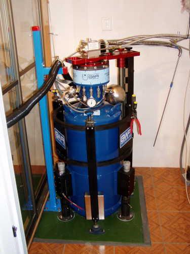
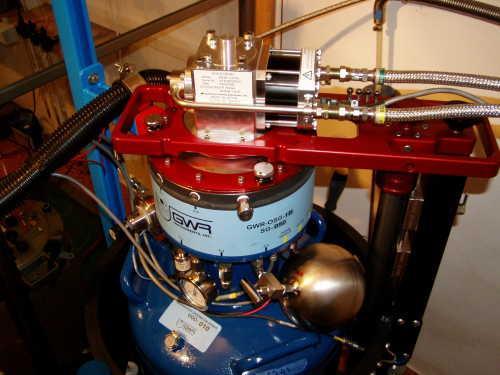
32 Tidal Gravimetry at GO Pecný and Environmental Effects gravity time series by GWR OSG-050, Askania Gs15 No. 228 and by LCR 137 calibration by FG5 No. 215 absolute gravimeter very broadband 3-D seismometer climatological station meteorological parameters soil moisture ground water level
33 Thank you for your attention! for more detailed information please visit
PosKEN Related Activities in the Czech Republic
 Research Institute of Geodesy, Topography, and Cartography Geodetic Observatory Pecny Land Survey Office, Prague PosKEN Related Activities in the Czech Republic 2014-2015 National Report J. Šimek 1 and
EUREF Related Activities in the Czech Republic
 Research Institute of Geodesy, Topography, and Cartography Geodetic Observatory Pecny Land Survey Office, Prague EUREF Related Activities in the Czech Republic 2014-2015 National Report J. Douša 1, V.
EUREF Related Activities in the Czech Republic
 Research Institute of Geodesy, Topography, and Cartography Geodetic Observatory Pecny Land Survey Office, Prague EUREF Related Activities in the Czech Republic 2011-2012 National Report J. Šimek1, J. Douša1,
EUREF Related Activities in the Czech Republic
 Research Institute of Geodesy, Topography, and Cartography Geodetic Observatory Pecny Land Survey Office, Prague EUREF Related Activities in the Czech Republic 2015-2016 National Report J. Douša 1, V.
EUREF Related Activities
 Symposium of the IAG Subcommission for Europe (EUREF) Chisinau, Moldova, 25 28 May, 2011 National Report of the Czech Republic EUREF Related Activities in the Czech Republic 2010-2011 National Report presented
Integrated geodetic infrastructure at the Geodetic Observatory Pecný, Czech Republic, in service of national and international GNSS projects
 Integrated geodetic infrastructure at the Geodetic Observatory Pecný, Czech Republic, in service of national and international GNSS projects Pavel NOVÁK, Czech Republic Key words: geodesy, reference systems,
National Report of the Czech Republic EUREF Related Activities in the Czech Republic National Report. presented by J.
 Symposium of the IAG Subcommission for Europe (EUREF) Vienna, Austria, 1-4 June, 2005 National Report of the Czech Republic EUREF Related Activities in the Czech Republic 2004-2005 National Report presented
Towards a EUREF Service Providing Real-time GNSS Clock and Orbit Corrections
 Towards a EUREF Service Providing Real-time GNSS Clock and Orbit Corrections G. Weber 1), W. Söhne 1), A. Stürze 1), L. Mervart 2) 1) Federal Agency for Cartography and Geodesy, Frankfurt am Main, Germany
Some Metrological Issues of GNSS Positioning: Case Study for the Czech Republic
 Some Metrological Issues of GNSS Positioning: Case Study for the Czech Republic Jaroslav Šimek Research Institute of Geodesy, Topography and Cartography - Geodetic Observatory Pecný The research is supported
Real-Time and Multi-GNSS Key Projects of the International GNSS Service
 Real-Time and Multi-GNSS Key Projects of the International GNSS Service Urs Hugentobler, Chris Rizos, Mark Caissy, Georg Weber, Oliver Montenbruck, Ruth Neilan EUREF 2013 Symposium Budapest, Hungary, May
VESOG GNSS Network in Czech Republic
 1 VESOG GNSS Network in Czech Republic Jakub Kostelecký (RIGTC) JAKUB.KOSTELECKY@PECNY.CZ CzechGeo/EPOS Workshop November 16, 2016, GFU, Prague, Czech Republic VESOG GNSS network 2 VESOG = Research and
EPN-Repro2: A Reference Tropospheric Dataset over Europe
 EPN-Repro2: A Reference Tropospheric Dataset over Europe R. Pacione (1), A. Araszkiewicz (2), E. Brockmann (3), J. Dousa (4) (1) e-geos S.p.A, ASI/CGS, Italy (2) Military University of Technology, Poland
Multi-GNSS real-time troposphere delay estimation
 Multi-GNSS real-time troposphere delay estimation Jaroslaw Bosy, Tomasz Hadas, Jak Kaplon, Kamil Kazmierski The 7th China Satellite Navigation Conference, May 18-20 Changsha China, Session S1: BDS/GNSS
ASG-EUPOS reference system
 Head Office of Geodesy and Cartography Department of Geodesy, Cartography and GIS ASG-EUPOS reference system Last year activities and future plans Szymon Wajda Prime specialist Bratislava, 21-22.11.2017
EUREF Permanent GNSS Network Carine Royal Observatory of Belgium
 ENEON first workshop Observing Europe: Networking the Earth Observation Networks in Europe EUREF Permanent GNSS Network Carine Bruyninx/C.Bruyninx@oma.be Royal Observatory of Belgium 1. About your network
Real-Time GNSS EUREF-IP Pilot Project
 Real-Time GNSS EUREF-IP Pilot Project G. Weber, BKG, Frankfurt 1. Status: Network, coverage, contributors 2. White Paper: Real-time GNSS in Routine EPN Operations 3. Real-time GNSS tools: BNC, client for
TESTING OF GNSS MULTIPATH IN DIFFERENT OBSERVATIONAL CONDITIONS AT ONE STATIONARY STATION
 Acta Geodyn. Geomater., Vol. 4, No. 43 (88), 45 49, 07 DOI: 0.368/AGG.07.003 journal homepage: https://www.irsm.cas.cz/acta ORIGINAL PAPER TESTING OF GNSS MULTIPATH IN DIFFERENT OBSERVATIONAL CONDITIONS
LONG-TERM POSITIONAL MONITORING OF STATION VYHL OF THE SNĚŽNÍK NETWORK
 Acta Geodyn. Geomater., Vol. 4, No. 4 (148), 201-206, 2007 LONG-TERM POSITIONAL MONITORING OF STATION VYHL OF THE SNĚŽNÍK NETWORK Otakar ŠVÁBENSKÝ * and Josef WEIGEL Brno University of Technology, Department
Global and Regional Real-Time Infrastructure for open access use
 Global and Regional Real-Time Infrastructure for open access use Axel Rülke Federal Agency for Cartography and Geodesy Branch Office Leipzig, Germany Tutorial on (Open) Real-Time Infrastructure and Applications
Precise GNSS analyses for troposphere monitoring by Geodetic Observatory Pecný analysis center
 Precise GNSS analyses for troposphere monitoring by Geodetic Observatory Pecný analysis center Douša Jan, Václavovic Pavel Research Institute of Geodesy, Topography and Cartography (RIGTC) JAN.DOUSA@PECNY.CZ
NTRIP Background History, Development & BKG. Networked Transport of RTCM via Internet Protocol
 Networked Transport of RTCM via Internet Protocol Networked Transport of RTCM via Internet Protocol Bundesamt für Kartographie und Geodäsie Motivation: Use Internet to transport GNSS corrections Communication
ASG-EUPOS DENSIFICATION OF EUREF PERMANENT NETWORK ON THE TERRITORY OF POLAND
 ASG-EUPOS DENSIFICATION OF EUREF PERMANENT NETWORK ON THE TERRITORY OF POLAND 1. INTRODUCTION Jarosław Bosy 1,2) Artur Oruba 1) Wieslaw Graszka 1) Marcin Leonczyk 1) Marcin Ryczywolski 1) 1) Head Office
CODE. L. Prange, R. Dach, S. Schaer, S. Lutz, A. Jäggi
 source: https://doi.org/10.7892/boris.44252 downloaded: 13.3.2017 Experiences with IGS MGEX data analysis at CODE. L. Prange, R. Dach, S. Schaer, S. Lutz, A. Jäggi Astronomical Institute, University of
NATIONAL REPORT OF POLAND TO EUREF 2012
 NATIONAL REPORT OF POLAND TO EUREF 2012 Jan Krynski Institute of Geodesy and Cartography, Warsaw Jerzy B. Rogowski Warsaw University of Technology, Warsaw Outline Main geodetic activities at the national
Performance Evaluation Of Real Time Precise Point Positioning (RT-PPP) In Static & Kinematic Modes In Egypt
 In Static & Kinematic Modes In Egypt") Performance Evaluation Of Real Time Precise Point Positioning (RT-PPP) In Static & Kinematic Modes In Egypt Eng. Ahmed Mansour Abdallah Dr. Mahmoud Abd Rabbou Prof. Adel El.shazly Geomatic Branch, Civil
Performance Evaluation Of Real Time Precise Point Positioning (RT-PPP) In Static & Kinematic Modes In Egypt Eng. Ahmed Mansour Abdallah Dr. Mahmoud Abd Rabbou Prof. Adel El.shazly Geomatic Branch, Civil
EUPOS - EUROPEAN POSITION DETERMINATION SYSTEM INITIATIVE
 EUPOS - EUROPEAN POSITION DETERMINATION SYSTEM INITIATIVE Dr. Branislav Droščák EUPOS chairman & Geodetic and Cartographic institute Bratislava CLGE General Assembly March 22.-23. 2019. Sofia, Bulgaria
Advanced Global Navigation Satellite Systems tropospheric products for monitoring severe weather events and climate (GNSS4SWEC)
") Advanced Global Navigation Satellite Systems tropospheric products for monitoring severe weather events and climate (C) Y1 Y1 Y1 G. Guerova (1), J. Jones (2), J. Dousa (3), G. Dick (4), S. de Haan (5),
Advanced Global Navigation Satellite Systems tropospheric products for monitoring severe weather events and climate (C) Y1 Y1 Y1 G. Guerova (1), J. Jones (2), J. Dousa (3), G. Dick (4), S. de Haan (5),
EUPOS - European Position Determination System Status and current issues
 EUPOS - European Position Determination System Status and current issues Office of the International EUPOS Steering Committee Senate Department for Urban Development, Land Berlin, Germany Symposium of
The IGS Real-time Pilot Project
 The IGS Real-time Pilot Project The Development of Real-time IGS Correction Products for Precise Point Positioning Mark Caissy, Georg Weber, Loukis Agrotis, Gerhard Wübbena, and Manuel Hernández-Pajares
OF POLAND TO EUREF 2009
 NATIONAL REPORT OF POLAND TO EUREF 2009 Jan Krynski Institute of Geodesy and Cartography, Warsaw Jerzy B. Rogowski Warsaw University of Technology, Warsaw Outline Main geodetic activities at the national
EPN-related Activities at ASI/CGS
 EPN-related Activities at ASI/CGS R. Pacione, B. Pace, G. Colucci, e-geos ASI/CGS Matera, Italy G. Bianco, Agenzia Spaziale Italiana, CGS Matera, Italy ASI/CGS solutions delivered to EF Using IGS FINAL
National Report of Austria
 National Report of Austria EUREF 05 Vienna 1.6-3.6. 2005 Ernst Zahn - BEV Vienna ISR - Space Research Institute / Austrian Academy of Sciences - Österreichische Akademie der Wissenschaften (ÖAW) BEV -
Geodetic policy for Ireland and Northern Ireland
 Geodetic policy for Ireland and Northern Ireland Background Ordnance Survey Ireland (OSi) is the National Mapping Agency (NMA) of the Republic of Ireland. The Ordnance Survey of Northern Ireland (OSNI)
Precise Positioning GNSS Applications
 Precise Point Positioning: Is the Era of Differential GNSS Positioning Drawing to an End? School of Surveying & Spatial Information Systems, UNSW, Sydney, Australia Chris Rizos 1, Volker Janssen 2, Craig
ROMPOS FOR CADASTRE APPLICATIONS
 International Symposium on Global Navigation Satellite Systems, Space-Based and Ground-Based Augmentation Systems and Applications 2009; Berlin, Germany, 30 November - 2 December 2009 ROMPOS FOR CADASTRE
THE PERMANENT MODRA-PIESOK GPS STATION MODRA- PIESOK AND ITS LONG-TERM AND SHORT-TERM STABILITY
 Slovak Journal of Civil Engineering, Vol. IX, No. 1-2, 2001 THE PERMANENT MODRA-PIESOK GPS STATION MODRA- PIESOK AND ITS LONG-TERM AND SHORT-TERM STABILITY Ján Hefty, Ph.D, Assoc. Prof. Department of Theoretical
Establishment of Karadeniz Technical University Permanent GNSS Station As Reactivated of TRAB IGS Station
 Establishment of Karadeniz Technical University Permanent GNSS Station As Reactivated of TRAB IGS Station Selma Zengin Kazancı, Emine Tanır Kayıkçı Karadeniz Technical University, Department of Geomatics
Enhancing the Swiss Permanent GPS Network (AGNES) for GLONASS
 for GLONASS") Enhancing the Swiss Permanent GPS Network (AGNES) for GLONASS D. INEICHEN, E. BROCKMANN, S. SCHAER 1 1 Abstract Since 1998 swisstopo has been operating the Automated GPS Network of Switzerland (AGNES)
Enhancing the Swiss Permanent GPS Network (AGNES) for GLONASS D. INEICHEN, E. BROCKMANN, S. SCHAER 1 1 Abstract Since 1998 swisstopo has been operating the Automated GPS Network of Switzerland (AGNES)
Cross-Border EUPOS Data Exchange First Experience
 Cross-Border EUPOS Data Exchange First Experience Eimuntas Paršeliūnas, Marius Petniūnas, Domantas Bručas (Institute of Geodesy of Vilnius Gediminas Technical University, Lithuania) Wieslaw Graszka (Head
PERSPECTIVES OF FREE GNSS POST-PROCESSING SOFTWARE USING
 XIII International forum «INTEREXPO GEO-Siberia 2017» PERSPECTIVES OF FREE GNSS POST-PROCESSING SOFTWARE USING S. Shevchuk, L. Lipatnikov, K. Malyutina (Siberian State University of Geosystems and Technologies)
The International GNSS Service (IGS): Product and Services
: Product and Services") The International GNSS Service (IGS): Product and Services Ruth E. Neilan 1, Chris Rizos 2 1 Director, IGS Central Bureau, NASA/JPL, Pasadena, USA 2 VP IAG, IGS Governing Board, UNSW, Sydney, Australia
The International GNSS Service (IGS): Product and Services Ruth E. Neilan 1, Chris Rizos 2 1 Director, IGS Central Bureau, NASA/JPL, Pasadena, USA 2 VP IAG, IGS Governing Board, UNSW, Sydney, Australia
National report of Finland
 National report of Finland Matti Ollikainen, Jorma Jokela, Markku Poutanen, Ruizhi Chen and Jaakko Mäkinen, Finnish Geodetic Institute, P.O.Box 15, 02431 Masala, Finland EUREF Symposium 2006, June 14-17,
Homogeneous tropospheric path delays from GNSS re-processing by GOP
 Homogeneous tropospheric path delays from GNSS re-processing by GOP Jan Douša, Pavel Václavovic, Michal Eliaš, RIGTC, The Czech Republic jan.dousa@pecny.cz June 6-8, 2016, Budapest, Hungary Outline 2 Introduction
National Report of Greece to EUREF 2010
 National Report of Greece to EUREF 2010 M. Gianniou KTIMATOLOGIO S.A. (Hellenic Cadastre) 1 Introduction The HEllenic POsitioning System (HEPOS) is an RTK network consisting of 98 reference stations that
Alberding solutions for GNSS infrastructure operators
 Tamás Horváth Alberding solutions for GNSS infrastructure operators 21.11.2017 1/35 Alberding solutions for GNSS infrastructure operators Tamás Horváth Alberding GmbH 4 th EUPOS Technical Meeting 21-22
EUPOS: Unified GNSS Augmentation Infrastructure and International Cooperation in Central and Eastern Europe
 EUPOS: Unified GNSS Augmentation Infrastructure and International Cooperation in Central and Eastern Europe Senate Department for Urban Development Geodetic Reference Systems Fehrbelliner Platz 1, 10707
National Report of Greece to EUREF 2009
 National Report of Greece to EUREF 2009 M. Gianniou KTIMATOLOGIO S.A. (Hellenic Cadastre) 1 Introduction In 2007, KTIMATOLOGIO S.A (Hellenic Cadastre) established HEPOS, the HEllenic POsitioning System,
Report of the Troposphere Coordinator
 Report of the Troposphere Coordinator R. Pacione e-geos, ASI/CGS-Matera, Italy 1 Outline Key Milestone in the EPN Tropospheric Products GNSS-Meteorology Concept EPN ZTD Time Series - 2 nd EPN Reprocessing
Quasi-Zenith Satellite System (QZSS)
") Transmission of Augmentation Corrections using the Japanese QZSS for Real-Time Precise Point Positioning in Australia Ken Harima 1, Suelynn Choy 1, Mazher Choudhury 2, Chris Rizos 2, Satoshi Kogure 3 1
Transmission of Augmentation Corrections using the Japanese QZSS for Real-Time Precise Point Positioning in Australia Ken Harima 1, Suelynn Choy 1, Mazher Choudhury 2, Chris Rizos 2, Satoshi Kogure 3 1
HEAD OFFICE OF GEODESY AND CARTOGRAPHY. Wspolna 2 Str., Warsaw, Poland ASG-EUPOS THE POLISH CONTRIBUTION TO THE EUPOS PROJECT
 HEAD OFFICE OF GEODESY AND CARTOGRAPHY Wspolna 2 Str., 00-926 Warsaw, Poland ASG-EUPOS THE POLISH CONTRIBUTION TO THE EUPOS PROJECT Project Part-Financed by European Union European Regional Development
SKPOS NOT ONLY POSITIONING SERVICE R&D PROJECTS SUPPORTER
 SKPOS NOT ONLY POSITIONING SERVICE R&D PROJECTS SUPPORTER Ing. Branislav Droščák, PhD. Geodetic and Cartographic Institute BRATISLAVA branislav.droscak@skgeodesy.sk International scientific and methodological
SKPOS. Slovak real-time positioning service - a multifunctional tool for precise object and phenomena positioning
 SKPOS Slovak real-time positioning service - a multifunctional tool for precise object and phenomena positioning WHAT IS SKPOS AND HOW DOES IT WORK? Slovak real-time positioning service is a multifunctional
Trimble GNSS Infrastructure
 Trimble GNSS Infrastructure A History of Innovation Trimble, the first company to offer commercial GPS products company to integrate GPS with communications technology RTK system in the market in 1994
Real-time PPP Results From Global Orbit and Clock Corrections
 BKG, Frankfurt a.m. Real-time PPP Results From Global Orbit and Clock Corrections Yüksel Altiner 1, Leos Mervart 2, Peter Neumaier 1, Wolfgang Söhne 1, Georg Weber 1 1 Federal Agency for Cartography and
AOS STUDIES ON USE OF PPP TECHNIQUE FOR TIME TRANSFER
 AOS STUDIES ON USE OF PPP TECHNIQUE FOR TIME TRANSFER P. Lejba, J. Nawrocki, D. Lemański, and P. Nogaś Space Research Centre, Astrogeodynamical Observatory (AOS), Borowiec, ul. Drapałka 4, 62-035 Kórnik,
Fast convergence of Trimble CenterPoint RTX by regional augmentation
 Fast convergence of Trimble CenterPoint RTX by regional augmentation Dr. Ralf Drescher Trimble Terrasat GmbH, Munich EGU General Assembly 2015, Vienna Thursday, 16 April 2015 Outline Introduction CenterPoint
Multi-GNSS Environment. Chris Rizos UNSW, Australia President IAG
 Multi-GNSS Environment Chris Rizos UNSW, Australia President IAG Visit official GNSS web sites: GPS - www.navcen.uscg.gov & www.gps.gov GLONASS - glonass-ianc.rsa.ru/en/ Galileo - www.esa.int/our_activities/navigation
GNSS Low-Cost High-Accuracy Receiver (L-CHAR)
") GNSS Low-Cost High-Accuracy Receiver (L-CHAR) Dinesh Manandhar Center for Spatial Information Science The University of Tokyo Contact Information: dinesh@iis.u-tokyo.ac.jp Slide : 1 High Accuracy Receivers
GNSS Low-Cost High-Accuracy Receiver (L-CHAR) Dinesh Manandhar Center for Spatial Information Science The University of Tokyo Contact Information: dinesh@iis.u-tokyo.ac.jp Slide : 1 High Accuracy Receivers
Leica GRX1200+ Series High Performance GNSS Reference Receivers
 Leica GRX1200+ Series High Performance GNSS Reference Receivers Leica GRX1200+ Series For permanent reference stations The Leica GRX1200+ Series, part of Leica's future proof System 1200, is designed specifically
magicgnss: QUALITY DATA, ALGORITHMS AND PRODUCTS FOR THE GNSS USER COMMUNITY
 SEMANA GEOMATICA 2009 magicgnss: QUALITY DATA, ALGORITHMS AND PRODUCTS FOR THE GNSS USER COMMUNITY MARCH 3, 2009 BARCELONA, SPAIN SESSION: GNSS PRODUCTS A. Mozo P. Navarro R. Píriz D. Rodríguez March 3,
MGA Webinar Series : 1 Very Cheap RTK Receivers: Changing the Landscape of Positioning Services
 MGA Webinar Series : 1 Very Cheap RTK Receivers: Changing the Landscape of Positioning Services Dinesh Manandhar Center for Spatial Information Science The University of Tokyo Contact Information: dinesh@iis.u-tokyo.ac.jp
Introduction to GNSS Base-Station
 Introduction to GNSS Base-Station Dinesh Manandhar Center for Spatial Information Science The University of Tokyo Contact Information: dinesh@iis.u-tokyo.ac.jp Slide : 1 Introduction GPS or GNSS observation
GNSS Analysis with Galileo Observations in the Subnetwork of the BEK Analysis Centre
 GNSS Analysis with Galileo Observations in the Subnetwork of the BEK Analysis Centre Christof Völksen Bavarian Academy of Sciences and Humanities (BAdW) Tomasz Liwosz Warsaw University of Technology, Warsaw,
Updated Options and New Products of EPN Analysis
 EUREF Symposium in London, UK, 6 9 June 27 Updated Options and New Products of EPN Analysis H. Habrich EPN Analysis Coordinator Federal Agency for Cartography and Geodesy, Frankfurt, Germany Abstract The
SSR Technology for Scalable Real-Time GNSS Applications
 SSR Technology for Scalable Real-Time GNSS Applications Gerhard Wübbena, Jannes Wübbena, Temmo Wübbena, Martin Schmitz Geo++ GmbH 30827 Garbsen, Germany www.geopp.de Abstract SSR Technology for scalable
CROPOS as Support of Geodetic Infrastructure in Croatia
 CROPOS as Support of Geodetic Infrastructure in Croatia Dr. Sc. Danko Markovinović - Croatia CLGE VicePresident The Geodetic Infrastructure in Europe - today and tomorrow Sweden...Umeå...22-23 June 2011
Leica GRX1200 Series High Performance GNSS Reference Receivers
 Leica GRX1200 Series High Performance GNSS Reference Receivers Leica GRX1200 Series For permanent reference stations The Leica GRX1200 Series, part of Leica s new System 1200, is designed specifically
FIELD TEST OF THE GPS+GLONASS RTK AT THE CAGLIARI PERMANENT STATION VIA INTERNET. Giannina Sanna, Giuseppina Vacca
 FIELD TEST OF THE GPS+GLONASS RTK AT THE CAGLIARI PERMANENT STATION VIA INTERNET Giannina Sanna, Giuseppina Vacca University of Cagliari Department of Structural Engineering P.zza D Armi 913 Cagliari,
GNSS Accuracy Improvements through Multipath Mitigation with New Signals and services
 GNSS Accuracy Improvements through Multipath Mitigation with New Signals and services Andrey Veytsel, Ph.D Moscow Technical University 10 Meeting of the International Committee on Global Navigation Satellite
GEODETIC AND NON GEODETIC APPLICATIONS PERFORMED BY WUT LAC
 WARSAW UNIWERSITY OF TECHNOLOGY Institute of Geodesy and Geodetic Astronomy Pl. Politechniki 1, 00-661 Warsaw, Poland igga@gik.pw.edu.pl, phone (+48 22) 622-85-15 Mariusz Figurski, Lech Kujawa GEODETIC
UNAVCO's Community Planning for real-time GPS in Earthscope's Plate Boundary Observatory
 Click to edit Master slide title UNAVCO's Community Planning for real-time GPS in Earthscope's Plate Boundary Observatory Chuck Meertens (presenting Author) David Mencin William Hammond John Langbein Bob
GUIDELINES FOR EPN STATIONS & OPERATIONAL CENTRES
 Guidelines for EPN Stations & Operational Centres Page 1 of 16 GUIDELINES FOR EPN STATIONS & OPERATIONAL CENTRES EPN Central Bureau C. Bruyninx, epncb@oma.be Updates: Regional data centre OLG is replaced
Philippine Geodetic Infrastructure Status, Challenges and Future Direction
 Philippine Geodetic Infrastructure Status, Challenges and Future Direction Engr. Charisma Victoria D. Cayapan National Mapping and Resource Information Authority PHILIPPINES Outline Evolution of Geodetic
Multisystem Real Time Precise-Point-Positioning, today with GPS+GLONASS in the near future also with QZSS, Galileo, Compass, IRNSS
 2 International Symposium on /GNSS October 26-28, 2. Multisystem Real Time Precise-Point-Positioning, today with +GLONASS in the near future also with QZSS, Galileo, Compass, IRNSS Álvaro Mozo García,
Status of Multi-GNSS Monitoring Network Establishment
 Status of Multi-GNSS Monitoring Network Establishment Japan Aerospace Exploration Agency Satoshi Kogure ICG-6 6 WG-A/D cross-session session @Tokyo, JAPAN 7 September, 2011 Contents Introduction Overview
The Global Positioning Sytem II 10/19/2017
 The Global Positioning System II Field Experiments 10/19/2017 5-1 Mexico DGPS Field Campaign Cenotes in Tamaulipas, MX, near Aldama 10/19/2017 5-2 Are Cenote Water Levels Related? 10/19/2017 5-3 M. Helper,
Tamás Horváth. 06 June 2012
 Tamás Horváth Software solutions for GNSS infrastructure monitoring 06 June 2012 1/18 Software solutions for GNSS infrastructure monitoring Tamás Horváth Alberding GmbH 06 June 2012 Tamás Horváth Software
European Position Determination System. Technical Standards
 European Position Determination System Technical Standards Revised 2 nd Edition 24 April 2008 Resolution of the International EUPOS Steering Committee 13 th Conference, Bucharest, Romania, 23 24 April
What makes the positioning infrastructure work. Simon Kwok Chairman, Land Surveying Division Hong Kong Institute of Surveyors
 What makes the positioning infrastructure work The experience of the Hong Kong Satellite Positioning Reference Station Network Simon Kwok Chairman, Land Surveying Division Hong Kong Institute of Surveyors
WHU s developments for the MGEX precise products and the GNSS ultra-rapid products
 IGS Workshop 2016 WHU s developments for the MGEX precise products and the GNSS ultra-rapid products Chuang Shi; Qile Zhao; Min Li; Jing Guo; Jingnan Liu Presented by Jianghui Geng GNSS Research Center,
Real-time Stream Conversion to RTCM-3 MSM and RINEX-3 in IGS/MGEX Context
 Real-time Stream Conversion to RTCM-3 MSM and RINEX-3 in IGS/MGEX Context Georg Weber (BKG), Ken MacLeod (NRCan), Leos Mervart (CTU), Oliver Montenbruck (DLR), James Perlt (BKG), Dirk Stöcker (Alberding),
The Global Positioning System II Field Experiments
 The Global Positioning System II Field Experiments 5-1 Mexico DGPS Field Campaign Cenotes in Tamaulipas, MX, near Aldama 5-2 Are Cenote Water Levels Related? 5-3 DGPS Static Survey of Cenote Water Levels
The International Scene: How Precise Positioning Will Underpin Critical GNSS Applications
 The International Scene: How Precise Positioning Will Underpin Critical GNSS Applications School of Civil & Environmental Engineering, UNSW, Sydney, Australia Chris Rizos Member of the IGS Governing Board
ION GNSS Galileo, an ace up in the sleeve for PPP techniques
 ION GNSS+ 2016 an ace up in the sleeve for PPP techniques September 15 TH, 2016 Session D3: High Precision GNSS Positioning I. Rodríguez-Pérez, L. Martínez-Fernández, G. Tobías-González, J. D. Calle-Calle,
SUPPORT OF NETWORK FORMATS BY TRIMBLE GPSNET NETWORK RTK SOLUTION
 SUPPORT OF NETWORK FORMATS BY TRIMBLE GPSNET NETWORK RTK SOLUTION TRIMBLE TERRASAT GMBH, HARINGSTRASSE 19, 85635 HOEHENKIRCHEN, GERMANY STATUS The Trimble GPSNet network RTK solution was first introduced
Exploiting the high precision capabilities of the Hellenic Positioning System - HEPOS
 Exploiting the high precision capabilities of the Hellenic Positioning System - HEPOS M. Gianniou, D. Mastoris, I. Stavropoulou Geodetic Department KTIMATOLOGIO S.A. 339 Mesogion Ave., 15562 Holargos Greece
QZSS and LEX Signal. Performance of Real-Time Precise Point Positioning Using MADOCA-LEX Augmentation Messages. Outline
 Performance of Real-Time Precise Point Positioning Using MADOCA-LEX Augmentation Messages Suelynn Choy 1, Ken Harima 1, Mohammad Choudhury 2, Yong Li 2, Yaka Wakabayashi 3, Thomas Grinter 4, Satoshi Kogure
The Reasons to Succeed or to Fail a GNSS Network RTK Project
 The Reasons to Succeed or to Fail a GNSS Network RTK Project Joël van Cranenbroeck, Managing Director CGEOS Creative Geosensing sprl-s, Belgium Andy Yin, International Sales Director ComNav Technology
European Position Determination System (EUPOS )
") European Position Determination System (EUPOS ) Georgi MILEV, Bulgaria, Gerd ROSENTHAL, Germany and Keranka VASSILEVA, Bulgaria Key words: ABSTRACT The project EUPOS is an initiative to establish a uniform
European Position Determination System (EUPOS ) Georgi MILEV, Bulgaria, Gerd ROSENTHAL, Germany and Keranka VASSILEVA, Bulgaria Key words: ABSTRACT The project EUPOS is an initiative to establish a uniform
Integrity Monitoring in a VRS Network
 Integrity Monitoring in a VRS Network Bundesamt für Landestopografie Office fédéral de topographie Ufficio federale di topografia Uffizi federal da topografia Simon Grünig, swisstopo GPSNet User Conference,
Prospect for Global Positioning Augmentation Service by QZSS
 Prospect for Global Positioning Augmentation Service by QZSS Global Positioning Augmentation Service Corporation Director, Yoshikatsu Iotake Feb. 6, 2018 Copyright 2018 Global Positioning Augmentation
Implementation of New Positioning System in Riga
 Implementation of New Positioning System in Riga M.Abele (1), J.Balodis (1), K.Balodis (1), M.Caunite (1), I.Janpaule (1), A.Rubans (1), G.Silabriedis (1,2), I.Mitrofanovs(2), A.arinsjh (1) (1) University
EUREF 12: National Report of Austria
 EUREF 12: National Report of Austria N.Höggerl 1, J.Otter 1, D.Ruess 1, G.Stangl 2, E.Zahn 1, S.Krauss 3, H.-P.Ranner 3 1. Positioning 1.1 GGOS/GIAC GGOS is the Global Geodetic Observing System of the
Compact multi-gnss PPP corrections messages for transmission through a 250 bps channel
 Compact multi-gnss PPP corrections messages for transmission through a 250 bps channel Ken Harima, School of Science, RMIT University Suelynn Choy, School of Science, RMIT University Chris Rizos, School
Next Generation Positioning Infrastructure
 Next Generation Positioning Infrastructure The GNSS Network in the 21 st Century Joel VAN CRANENBROECK & Partners Beyond East & West GeoSensing Community 1 INFRASTRUCTURE "The installations that form the
GFZ Analysis Centre: Multi-GNSS Processing and Products
 GFZ Analysis Centre: Multi-GNSS Processing and Products Mathias Fritsche, Zhiguo Deng, Maik Uhlemann,Thomas Nischan, Markus Bradke, Markus Ramatschi, Andre Brand, Gerda Beeskow DeutschesGeoforschungsZentrum
Global Products for GPS Point Positioning Approaching Real-Time
 Global Products for GPS Point Positioning Approaching Real-Time Y. Gao 1, P. Heroux 2 and M. Caissy 2 1 Department of Geomatics Engineering, University of Calgary 2 Geodetic Survey Division, Natural Resources
THE CURRENT STATUS OF ASIA OCEANIA MULTI-GNSS DEMONSTRATION CAMPAIGN. Multi-GNSS Asia Secretariat June 4 th, th ICG Providers Forum
 THE CURRENT STATUS OF ASIA OCEANIA MULTI-GNSS DEMONSTRATION CAMPAIGN 1 Multi-GNSS Asia Secretariat June 4 th, 2012 8 th ICG Providers Forum ASIA OCEANIA MULTI-GNSS DEMONSTRATION CAMPAIGN Multi-GNSS Monitoring
HEIGHTING WITH GPS: POSSIBILITIES AND LIMITATIONS
 HEIGHTING WITH GPS: POSSIBILITIES AND LIMITATIONS Matthew B. Higgins ABSTRACT Global Positioning System (GPS) surveying is now seen as a true three dimensional tool and GPS heighting can be a viable alternative
ION GNSS 2011 FILLING IN THE GAPS OF RTK WITH REGIONAL PPP
 ION GNSS 2011 FILLING IN THE GAPS OF RTK WITH REGIONAL PPP SEPTEMBER 22 th, 2011 ION GNSS 2011. PORTLAND, OREGON, USA SESSION F3: PRECISE POSITIONING AND RTK FOR CIVIL APPLICATION C. García A. Mozo P.