Real-Time GNSS EUREF-IP Pilot Project
|
|
|
- Hilary Atkins
- 6 years ago
- Views:
Transcription
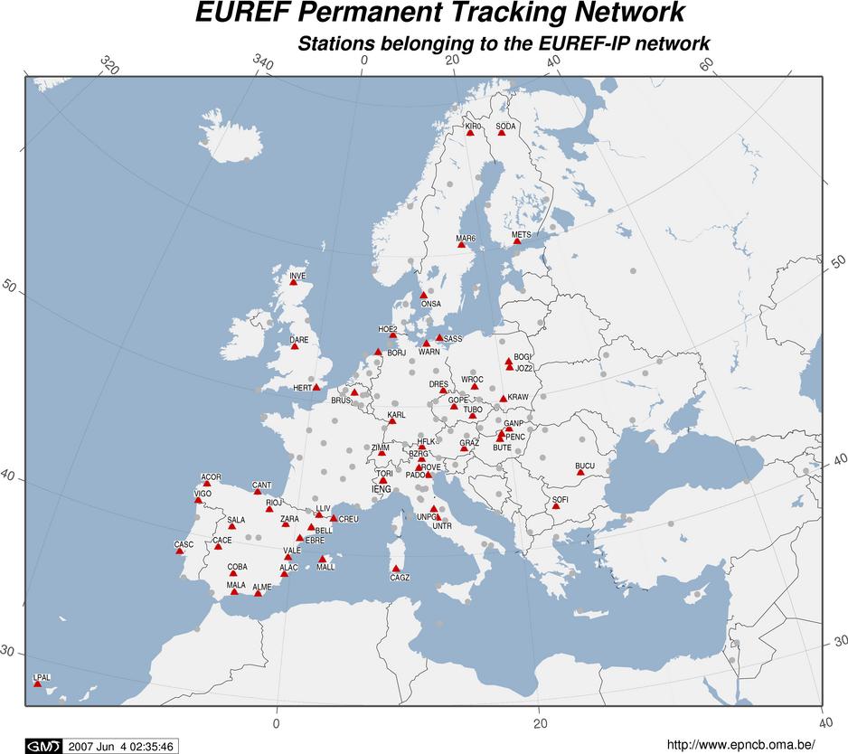
1 Real-Time GNSS EUREF-IP Pilot Project G. Weber, BKG, Frankfurt 1. Status: Network, coverage, contributors 2. White Paper: Real-time GNSS in Routine EPN Operations 3. Real-time GNSS tools: BNC, client for Windows Mobile 4. Products: RTNET, Real-time orbits & clocks 5. Real-time IGS: Call for Participation 6. The way ahead: Tools & Standardization
2
3 Contributors to 1. AGH University of Science and Technology - Poland (2) 2. Agricultural University of Wroclaw - Poland (1) 3. Agriculture Institute University of Milano - Italy (1) 4. Bucharest Technical University of Civil Engineering - Romania (1) 5. Budapest University of Technology and Economics - Hungary (2) 6. Bundesamt fuer Eich- und Vermessungswesen - Austria (2) 7. Czech Technical University CVUT - Czech Republic (1) 8. DIST Universita di Cagliari - Italy (1) 9. European Space Agency - Europe (1) 10. FOMI Satellite Geodetic Observatory - Hungary (1) 11. Fachhochschule Bochum - Germany (1) 12. Federal Agency for Cartography and Geodesy - Germany (17) 13. Finnish Geodetic Institute - Finland (3) 14. GOP Research Insitute of Geodesy Topography and Cartographie - Czech Republic (1) 15. Geodetic Institute University Warszawa - Poland (1) 16. Geodetic and Cartographic Institute - Slovakia (1) 17. Institut Cartografic de Catalunya - Spain (2) 18. Institut Geographique National - France (1) 19. Institute of Geodesy and Geodetic Astronomy Warsaw University of Technology - Poland (1) 20. Instituto Geografico Nacional - Spain (15) 21. Instituto Geografico Portugues - Portugal (1) 22. Instytut Geodezji i Kartografii Warszawie - Poland (1) 23. Istituto Nazionale di Ricerca Metrologica I.N.RI.M. - Italy (1) 24. KGSiN University of Warmia and Mazury - Poland (1) 25. Landesvermessung Bayern - Germany (1) 26. Landesvermessung Mecklenburg-Vorpommern - Germany (3) 27. Landesvermessung Saarland - Germany (1) 28. Landesvermessung Thueringen - Germany (1) 29. Leica Geosystems AG - Switzerland (1) 30. Leica Geosystems Sp.z.o.o - Poland (1) 31. Mairie de Cannes - France (1) 32. NERC Space Geodesy Facility - United Kingdom (1) 33. National Land Survey - Sweden (3) 34. Ordnance Survey - United Kingdom (2) 35. Politecnico di Torino - Italy (1) 36. Royal Observatory - Belgium (1) 37. SAPOS Berlin - Germany (1) 38. Satellite Observatory Lamkowko University of Warmia and Mazury - Poland (1) 39. Survey Sales and Hire - Ireland (2) 40. SwissTopo - Switzerland (1) 41. Techische Universitaet Wien - Austria (1) 42. Technical School of Rovereto - Italy (1) 43. Technical University Delft - The Netherlands (1) 44. Telespazio S.p.A. - Italy (2) 45. TopoBreda - Portugal (1) 46. Universitat die Perugia - Italy (2) 47. University Padova - Italy (2) 48. University Rome La Sapienza - Italy (1) 49. VUGTK Geodetic Observatory Pecny - Czech Republic (1) Total: 94 Streams
4 Real-time GNSS in Routine EPN Operations White Paper available from: guidelines/epnrt_whitepaper.pdf Turn EUREF-IP Pilot Project into a routine service Guidelines developed for Reference stations NTRIP Broadcasters High-rate RINEX Data Centers Real-time Analysis Centers Role of EPN Central Bureau
5 Reasons for EUREF-IP Integrate Real-time EPN stations in regional DGPS/RTK networks because They are the best real-time monitored long-term available reference stations on the continent. This allows easy real-time data exchange and saves costs. It enables EUREF to support dm-level positioning European-wide, consistently referred to ETRS89.

6 Streams from different casters Supports different formats Synchronised stream output High-rate RINEX
7 RMS of Discrepancies between Double Difference Clock Corrections: IGS Final Clocks vs. Broadcast or RTNET Clocks m-1 n-1 n 2 Σ Σ Σ [{(c k (t j )-c k (t i )) (c me (t j ) c me (t i ))} SOURCE_1 {(c k (t j )-c k (t i )) (c me (t j ) c me (t i ))} SOURCE_2 ] k=1 i=1 j=i+1 RMS = ± (m 1) * n * (n-1) / 2 c = Satellite clock correction t = Epoch i,j = Index for epochs k = Index for satellites me = Index for satellite with max. elevation m = Number of satellites n = Number of epochs SOURCE = Source of clocks
8
9
10 Thin lines: Broadcast clocks Thick lines: EUREF Real-time clock estimates Reaching ~10cm accuracy level after 10min 0m 10m 20min 30min 40min 50min
11 1. Real-time IGS Pilot Project, Call for Participation 1.1 Background 1.2 Goals and Objectives 1.3 Organizational Aspects 1.4 Project Committee 2. Call for Participation 2.1 Real-time Tracking Stations 2.2 Real-time Data Centers 2.3 Real-time Analysis Centers 2.4 Real-time Associate Analysis Centers 2.5 Real-time Analysis Center Coordinator 2.6 Real-time Network Management and Monitoring 2.7 Real-time Users 3. Instructions for Submitting Proposals 3.1 Proposal Form

12 Current Real-time IGS Resources
13 IGS: SOC/UDP vs. EURF: RTCM/NTRIP Handling GLONASS and GALILEO should be a must for both approaches. Consequently, extending the SOC/UDP approach when switching to GPS+GLO would be a necessity. However, all modern Internet-ready receivers already support the RTCM/NTRIP approach. How can station operators be persuaded to run an extra Linux PC on the site to support SOC/UPD if all what s needed is already integrated in the receiver? The suggestion is to closely cooperate with RTCM to develop RTCM v3 and NTRIP v2 in a way that it fully satisfies our needs. This could save us quite some work.
14 RTCM Working Group: State Space Chaired by G. Wuebbena Final goal: Concepts and Messages for all types of accuracy Step 1: Dual frequency Real-time PPP Message(s) for precise orbits and satellite clocks Step 2: Single frequency Real-time PPP Development of VTEC ionospheric messages Step 3: RTK-PPP STEC, troposphere, delays, carrier phase ambiguity (maintain integer nature)
15 New RTCM Working Group: Extension of RTCM v3 to... Overcome the current limitation of handling only one code per frequency Current problem: L2C Future problems: L5 and GALILEO Develop new RTCM v3 format which allows to transport any observation becoming available
Towards a EUREF Service Providing Real-time GNSS Clock and Orbit Corrections
 Towards a EUREF Service Providing Real-time GNSS Clock and Orbit Corrections G. Weber 1), W. Söhne 1), A. Stürze 1), L. Mervart 2) 1) Federal Agency for Cartography and Geodesy, Frankfurt am Main, Germany
NTRIP Background History, Development & BKG. Networked Transport of RTCM via Internet Protocol
 Networked Transport of RTCM via Internet Protocol Networked Transport of RTCM via Internet Protocol Bundesamt für Kartographie und Geodäsie Motivation: Use Internet to transport GNSS corrections Communication
Global and Regional Real-Time Infrastructure for open access use
 Global and Regional Real-Time Infrastructure for open access use Axel Rülke Federal Agency for Cartography and Geodesy Branch Office Leipzig, Germany Tutorial on (Open) Real-Time Infrastructure and Applications
Real-time PPP Results From Global Orbit and Clock Corrections
 BKG, Frankfurt a.m. Real-time PPP Results From Global Orbit and Clock Corrections Yüksel Altiner 1, Leos Mervart 2, Peter Neumaier 1, Wolfgang Söhne 1, Georg Weber 1 1 Federal Agency for Cartography and
PosKEN Related Activities in the Czech Republic
 Research Institute of Geodesy, Topography, and Cartography Geodetic Observatory Pecny Land Survey Office, Prague PosKEN Related Activities in the Czech Republic 2014-2015 National Report J. Šimek 1 and
SUPPORT OF NETWORK FORMATS BY TRIMBLE GPSNET NETWORK RTK SOLUTION
 SUPPORT OF NETWORK FORMATS BY TRIMBLE GPSNET NETWORK RTK SOLUTION TRIMBLE TERRASAT GMBH, HARINGSTRASSE 19, 85635 HOEHENKIRCHEN, GERMANY STATUS The Trimble GPSNet network RTK solution was first introduced
EUREF Permanent GNSS Network Carine Royal Observatory of Belgium
 ENEON first workshop Observing Europe: Networking the Earth Observation Networks in Europe EUREF Permanent GNSS Network Carine Bruyninx/C.Bruyninx@oma.be Royal Observatory of Belgium 1. About your network
EUPOS: Unified GNSS Augmentation Infrastructure and International Cooperation in Central and Eastern Europe
 EUPOS: Unified GNSS Augmentation Infrastructure and International Cooperation in Central and Eastern Europe Senate Department for Urban Development Geodetic Reference Systems Fehrbelliner Platz 1, 10707
Real-Time and Multi-GNSS Key Projects of the International GNSS Service
 Real-Time and Multi-GNSS Key Projects of the International GNSS Service Urs Hugentobler, Chris Rizos, Mark Caissy, Georg Weber, Oliver Montenbruck, Ruth Neilan EUREF 2013 Symposium Budapest, Hungary, May
Performance Evaluation Of Real Time Precise Point Positioning (RT-PPP) In Static & Kinematic Modes In Egypt
 In Static & Kinematic Modes In Egypt") Performance Evaluation Of Real Time Precise Point Positioning (RT-PPP) In Static & Kinematic Modes In Egypt Eng. Ahmed Mansour Abdallah Dr. Mahmoud Abd Rabbou Prof. Adel El.shazly Geomatic Branch, Civil
Performance Evaluation Of Real Time Precise Point Positioning (RT-PPP) In Static & Kinematic Modes In Egypt Eng. Ahmed Mansour Abdallah Dr. Mahmoud Abd Rabbou Prof. Adel El.shazly Geomatic Branch, Civil
EUPOS - EUROPEAN POSITION DETERMINATION SYSTEM INITIATIVE
 EUPOS - EUROPEAN POSITION DETERMINATION SYSTEM INITIATIVE Dr. Branislav Droščák EUPOS chairman & Geodetic and Cartographic institute Bratislava CLGE General Assembly March 22.-23. 2019. Sofia, Bulgaria
Tamás Horváth. 06 June 2012
 Tamás Horváth Software solutions for GNSS infrastructure monitoring 06 June 2012 1/18 Software solutions for GNSS infrastructure monitoring Tamás Horváth Alberding GmbH 06 June 2012 Tamás Horváth Software
EUREF Related Activities in the Czech Republic
 Research Institute of Geodesy, Topography, and Cartography Geodetic Observatory Pecny Land Survey Office, Prague EUREF Related Activities in the Czech Republic 2012-2013 National Report J. Šimek 1, J.
EPN-Repro2: A Reference Tropospheric Dataset over Europe
 EPN-Repro2: A Reference Tropospheric Dataset over Europe R. Pacione (1), A. Araszkiewicz (2), E. Brockmann (3), J. Dousa (4) (1) e-geos S.p.A, ASI/CGS, Italy (2) Military University of Technology, Poland
Precise Positioning GNSS Applications
 Precise Point Positioning: Is the Era of Differential GNSS Positioning Drawing to an End? School of Surveying & Spatial Information Systems, UNSW, Sydney, Australia Chris Rizos 1, Volker Janssen 2, Craig
Multi-GNSS real-time troposphere delay estimation
 Multi-GNSS real-time troposphere delay estimation Jaroslaw Bosy, Tomasz Hadas, Jak Kaplon, Kamil Kazmierski The 7th China Satellite Navigation Conference, May 18-20 Changsha China, Session S1: BDS/GNSS
Quasi-Zenith Satellite System (QZSS)
") Transmission of Augmentation Corrections using the Japanese QZSS for Real-Time Precise Point Positioning in Australia Ken Harima 1, Suelynn Choy 1, Mazher Choudhury 2, Chris Rizos 2, Satoshi Kogure 3 1
Transmission of Augmentation Corrections using the Japanese QZSS for Real-Time Precise Point Positioning in Australia Ken Harima 1, Suelynn Choy 1, Mazher Choudhury 2, Chris Rizos 2, Satoshi Kogure 3 1
EUREF Related Activities in the Czech Republic
 Research Institute of Geodesy, Topography, and Cartography Geodetic Observatory Pecny Land Survey Office, Prague EUREF Related Activities in the Czech Republic 2014-2015 National Report J. Douša 1, V.
FIELD TEST OF THE GPS+GLONASS RTK AT THE CAGLIARI PERMANENT STATION VIA INTERNET. Giannina Sanna, Giuseppina Vacca
 FIELD TEST OF THE GPS+GLONASS RTK AT THE CAGLIARI PERMANENT STATION VIA INTERNET Giannina Sanna, Giuseppina Vacca University of Cagliari Department of Structural Engineering P.zza D Armi 913 Cagliari,
Trimble GPSNet 2.5 Software for GNSS Infrastructure: New Features. Martin Janousek - Trimble Technical Support - Infrastructure
 Trimble GPSNet 2.5 Software for GNSS Infrastructure: New Features Martin Janousek - Trimble Technical Support - Infrastructure GPSNet Users Seminar Munich, March 30 th /31 th 2006 Overview Support for
The IGS Real-time Pilot Project
 The IGS Real-time Pilot Project The Development of Real-time IGS Correction Products for Precise Point Positioning Mark Caissy, Georg Weber, Loukis Agrotis, Gerhard Wübbena, and Manuel Hernández-Pajares
Integrated geodetic infrastructure at the Geodetic Observatory Pecný, Czech Republic, in service of national and international GNSS projects
 Integrated geodetic infrastructure at the Geodetic Observatory Pecný, Czech Republic, in service of national and international GNSS projects Pavel NOVÁK, Czech Republic Key words: geodesy, reference systems,
ASG-EUPOS reference system
 Head Office of Geodesy and Cartography Department of Geodesy, Cartography and GIS ASG-EUPOS reference system Last year activities and future plans Szymon Wajda Prime specialist Bratislava, 21-22.11.2017
NATIONAL REPORT OF POLAND TO EUREF 2012
 NATIONAL REPORT OF POLAND TO EUREF 2012 Jan Krynski Institute of Geodesy and Cartography, Warsaw Jerzy B. Rogowski Warsaw University of Technology, Warsaw Outline Main geodetic activities at the national
Compact multi-gnss PPP corrections messages for transmission through a 250 bps channel
 Compact multi-gnss PPP corrections messages for transmission through a 250 bps channel Ken Harima, School of Science, RMIT University Suelynn Choy, School of Science, RMIT University Chris Rizos, School
Cross-Border EUPOS Data Exchange First Experience
 Cross-Border EUPOS Data Exchange First Experience Eimuntas Paršeliūnas, Marius Petniūnas, Domantas Bručas (Institute of Geodesy of Vilnius Gediminas Technical University, Lithuania) Wieslaw Graszka (Head
European Position Determination System (EUPOS )
") European Position Determination System (EUPOS ) Georgi MILEV, Bulgaria, Gerd ROSENTHAL, Germany and Keranka VASSILEVA, Bulgaria Key words: ABSTRACT The project EUPOS is an initiative to establish a uniform
European Position Determination System (EUPOS ) Georgi MILEV, Bulgaria, Gerd ROSENTHAL, Germany and Keranka VASSILEVA, Bulgaria Key words: ABSTRACT The project EUPOS is an initiative to establish a uniform
Fast convergence of Trimble CenterPoint RTX by regional augmentation
 Fast convergence of Trimble CenterPoint RTX by regional augmentation Dr. Ralf Drescher Trimble Terrasat GmbH, Munich EGU General Assembly 2015, Vienna Thursday, 16 April 2015 Outline Introduction CenterPoint
EUPOS - European Position Determination System Status and current issues
 EUPOS - European Position Determination System Status and current issues Office of the International EUPOS Steering Committee Senate Department for Urban Development, Land Berlin, Germany Symposium of
CODE. L. Prange, R. Dach, S. Schaer, S. Lutz, A. Jäggi
 source: https://doi.org/10.7892/boris.44252 downloaded: 13.3.2017 Experiences with IGS MGEX data analysis at CODE. L. Prange, R. Dach, S. Schaer, S. Lutz, A. Jäggi Astronomical Institute, University of
PPP with Ambiguity Resolution (AR) using RTCM-SSR
 using RTCM-SSR") PPP with Ambiguity Resolution (AR) using RTCM-SSR Gerhard Wübbena, Martin Schmitz, Andreas Bagge Geo++ GmbH 30827 Garbsen Germany www.geopp.de PPP with Ambiguity Resolution (AR) using RTCM-SSR Abstract
PPP with Ambiguity Resolution (AR) using RTCM-SSR Gerhard Wübbena, Martin Schmitz, Andreas Bagge Geo++ GmbH 30827 Garbsen Germany www.geopp.de PPP with Ambiguity Resolution (AR) using RTCM-SSR Abstract
Multisystem Real Time Precise-Point-Positioning, today with GPS+GLONASS in the near future also with QZSS, Galileo, Compass, IRNSS
 2 International Symposium on /GNSS October 26-28, 2. Multisystem Real Time Precise-Point-Positioning, today with +GLONASS in the near future also with QZSS, Galileo, Compass, IRNSS Álvaro Mozo García,
ROMPOS FOR CADASTRE APPLICATIONS
 International Symposium on Global Navigation Satellite Systems, Space-Based and Ground-Based Augmentation Systems and Applications 2009; Berlin, Germany, 30 November - 2 December 2009 ROMPOS FOR CADASTRE
EUREF Related Activities in the Czech Republic
 Research Institute of Geodesy, Topography, and Cartography Geodetic Observatory Pecny Land Survey Office, Prague EUREF Related Activities in the Czech Republic 2015-2016 National Report J. Douša 1, V.
EUREF Related Activities in the Czech Republic
 Research Institute of Geodesy, Topography, and Cartography Geodetic Observatory Pecny Land Survey Office, Prague EUREF Related Activities in the Czech Republic 2011-2012 National Report J. Šimek1, J. Douša1,
Role of Manufacturers to support Geodetic Infrastructure
 FIG / UN-GGIM-AP / JUPEM Geospatial and GNSS CORS Infrastructure Forum Kuala Lumpur, Malaysia 16-17 Oct 2016 Role of Manufacturers to support Geodetic Infrastructure Neil Ashcroft Leica Geosystems Information
ION GNSS 2011 FILLING IN THE GAPS OF RTK WITH REGIONAL PPP
 ION GNSS 2011 FILLING IN THE GAPS OF RTK WITH REGIONAL PPP SEPTEMBER 22 th, 2011 ION GNSS 2011. PORTLAND, OREGON, USA SESSION F3: PRECISE POSITIONING AND RTK FOR CIVIL APPLICATION C. García A. Mozo P.
GNSS Accuracy Improvements through Multipath Mitigation with New Signals and services
 GNSS Accuracy Improvements through Multipath Mitigation with New Signals and services Andrey Veytsel, Ph.D Moscow Technical University 10 Meeting of the International Committee on Global Navigation Satellite
Changes to university IPR regulations in Europe and their impact on academic patenting
 Changes to university IPR regulations in Europe and their impact on academic patenting Federica Rossi Birkbeck, University of London Aldo Geuna Universita di Torino Outline Changes in IPR regulations in
EUPOS Central and Eastern European Differential (D)GNSS Infrastructure, and Cooperation
GNSS Infrastructure, and Cooperation") EUPOS Central and Eastern European Differential (D)GNSS Infrastructure, and Cooperation Office of the International EUPOS Steering Committee, Head Senate Department for Urban Development, State of Berlin,
EUPOS Central and Eastern European Differential (D)GNSS Infrastructure, and Cooperation Office of the International EUPOS Steering Committee, Head Senate Department for Urban Development, State of Berlin,
CONTRIBUTION OF EUPOS PERMANENT GPS NETWORK TO THE EUREF REFERENCE SYSTEM
 BERLIN SENATE, DEPARTMENT FOR URBAN DEVELOPMENT, GERMANY HEAD OFFICE OF GEODESY AND CARTOGRAPHY, WARSAW, POLAND FÖMI SATELLITE GEODETIC OBSERVATORY PENC, HUNGARY WARSAW UNIVERSITY OF TECHNOLOGY INSTITUTE
Geoscience & Positioning, Navigation and Timing Services for Canadians
 Geoscience & Positioning, Navigation and Timing Services for Canadians Calvin Klatt, Ph.D. Director and Chief Geodesist Natural Resources Canada / Directeur et géodésien principal Ressources naturelles
Alberding solutions for GNSS infrastructure operators
 Tamás Horváth Alberding solutions for GNSS infrastructure operators 21.11.2017 1/35 Alberding solutions for GNSS infrastructure operators Tamás Horváth Alberding GmbH 4 th EUPOS Technical Meeting 21-22
Number of married persons as a percentage of the total population aged 15 years and older
 Life Domain: Population, Households and Families Goal Dimension: Socio-Economic Structure Measurement Dimension: Population and Household Structure Subdimension: Structure of Population by Marital Status
MAGICGNSS RTCM-BASED SERVICE, A LEAP FORWARD TOWARDS MULTI- GNSS HIGH ACCURACY REAL-TIME PROCESSING
 ION GNSS 2015 MAGICGNSS RTCM-BASED SERVICE, A LEAP FORWARD TOWARDS MULTI- GNSS HIGH ACCURACY REAL-TIME PROCESSING SEPTEMBER 16 TH, 2015 - ION GNSS 2015, TAMPA, FLORIDA, USA SESSION E2A: NEXT GENERATION
Number of divorced persons as a percentage of the total population aged 15 years and older
 Life Domain: Population, Households and Families Goal Dimension: Socio-Economic Structure Measurement Dimension: Population and Household Structure Subdimension: Structure of Population by Marital Status
The International Scene: How Precise Positioning Will Underpin Critical GNSS Applications
 The International Scene: How Precise Positioning Will Underpin Critical GNSS Applications School of Civil & Environmental Engineering, UNSW, Sydney, Australia Chris Rizos Member of the IGS Governing Board
IMO WORLDWIDE RADIONAVIGATION SYSTEM (WWRNS) Study on Communication Techniques for High Accuracy DGPS in the Republic of Korea
 Study on Communication Techniques for High Accuracy DGPS in the Republic of Korea") INTERNATIONAL MARITIME ORGANIZATION E IMO SUB-COMMITTEE ON SAFETY OF NAVIGATION 52nd session Agenda item 12 NAV 52/INF.8 12 May 2006 ENGLISH ONLY WORLDWIDE RADIONAVIGATION SYSTEM (WWRNS) Study on Communication
INTERNATIONAL MARITIME ORGANIZATION E IMO SUB-COMMITTEE ON SAFETY OF NAVIGATION 52nd session Agenda item 12 NAV 52/INF.8 12 May 2006 ENGLISH ONLY WORLDWIDE RADIONAVIGATION SYSTEM (WWRNS) Study on Communication
RTCM-SSR Strategy of Bias Treatment
 RTCM-SSR Strategy of Bias Treatment Gerhard Wübbena Geo++ GmbH 30827 Garbsen Germany www.geopp.de Chair of RTCM-SSR WG www.rtcm.org RTCM-SC104 SSR Development working group established in 2007 3 message
Possibility of precise positioning and precise inshore navigation using RTK and Internet
 Possibility of precise positioning and precise inshore navigation using RTK and Internet. Kujawa & J. Rogowski Warsaw University of Technology, Warsaw, Poland ASTRACT: The practical need for GNSS positioning
PRELIMINARY RESULTS OF THE USE OF EUREF-IP PILOT PROJECT IN WARSAW METROPOLIS BASED ON TWO NTRIP SERVERS OF EPN STATIONS BOGI AND JOZ2
 Jan Cisak, Magdalena Mank, Lukasz Zak Institute of Geodesy and Cartography 27 Modzelewskiego St., 02-679 Warsaw, Poland astro@igik.edu.pl PRELIMINARY RESULTS OF THE USE OF EUREF-IP PILOT PROJECT IN WARSAW
Enhancing global PPP with Local Ionospheric Corrections
 Enhancing global PPP with Local Ionospheric Corrections Suelynn Choy 1, Ken Harima 1, Satoshi Kogure 2 1 School of Mathematical and Geospatial Sciences, RMIT University, Australia 2 Satellite Navigation
Leica GRX1200+ Series High Performance GNSS Reference Receivers
 Leica GRX1200+ Series High Performance GNSS Reference Receivers Leica GRX1200+ Series For permanent reference stations The Leica GRX1200+ Series, part of Leica's future proof System 1200, is designed specifically
Latest Developments in Network RTK Modeling to Support GNSS Modernization
 Journal of Global Positioning Systems (2007) Vol.6, No.1: 47-55 Latest Developments in Network RTK Modeling to Support GNSS Modernization Herbert Landau, Xiaoming Chen, Adrian Kipka, Ulrich Vollath Trimble
Leica GRX1200 Series High Performance GNSS Reference Receivers
 Leica GRX1200 Series High Performance GNSS Reference Receivers Leica GRX1200 Series For permanent reference stations The Leica GRX1200 Series, part of Leica s new System 1200, is designed specifically
Trimble GNSS Infrastructure
 Trimble GNSS Infrastructure A History of Innovation Trimble, the first company to offer commercial GPS products company to integrate GPS with communications technology RTK system in the market in 1994
European Position Determination System. Technical Standards
 European Position Determination System Technical Standards Revised 2 nd Edition 24 April 2008 Resolution of the International EUPOS Steering Committee 13 th Conference, Bucharest, Romania, 23 24 April
EUPOS European Position Determination System
 EUPOS European Position Determination System c/o Senate Department for Urban Development, State Berlin, Germany Umea, Sweden, 22 nd 23 rd 2011 The Geodetic Infrastructure in Europe today and tomorrow Slide
A Novel Device for Autonomous Real-Time Precise Positioning with Global Coverage
 A Novel Device for Autonomous Real-Time Precise Positioning with Global Coverage D. Calle, P. Navarro, A. Mozo, R. Píriz, D. Rodríguez, G. Tobías. GMV, Spain BIOGRAPHY David Calle has a Master of Science
Monitoring tool for EUPOS countries network RTK quality
 Monitoring tool for EUPOS countries network RTK quality Dr. Branislav Droščák & Karol Smolík Geodetic and Cartographic Institute BRATISLAVA EUPOS WG on Service Quality Monitoring branislav.droscak@skgeodesy.sk,
EUROPEAN POSITION DETERMINATION SYSTEM (EUPOS )
") 1 EUROPEAN POSITION DETERMINATION SYSTEM (EUPOS ) G. ROSENTHAL 1, G. MILEV 2, K. VASSILEVA 2 EUPOS: European Position Determination System 1. General 2. For position fixing with higher accuracy many countries
1 EUROPEAN POSITION DETERMINATION SYSTEM (EUPOS ) G. ROSENTHAL 1, G. MILEV 2, K. VASSILEVA 2 EUPOS: European Position Determination System 1. General 2. For position fixing with higher accuracy many countries
Positioning Techniques. João F. Galera Monico - UNESP Tuesday 12 Sep
 Positioning Techniques João F. Galera Monico - UNESP Tuesday 12 Sep Positioning methods Absolute Positioning Static and kinematic SPP and PPP Relative Positioning Static Static rapid Semi kinematic Kinematic
QZSS and LEX Signal. Performance of Real-Time Precise Point Positioning Using MADOCA-LEX Augmentation Messages. Outline
 Performance of Real-Time Precise Point Positioning Using MADOCA-LEX Augmentation Messages Suelynn Choy 1, Ken Harima 1, Mohammad Choudhury 2, Yong Li 2, Yaka Wakabayashi 3, Thomas Grinter 4, Satoshi Kogure
5.0% 0.0% -5.0% -10.0% -15.0% 10.0% 5.0% 0.0% -5.0% -10.0% -15.0% 10.0% 5.0% 0.0% -5.0% -10.0% 16.00% 13.00% 10.00% 7.00% 4.
 MARKETBEAT The DNA of Real Estate EUROPE A Cushman & Wakefield Research Publication Q4 2014 ICE RENTAL (YEAR-ON-YEAR) Q4 2012 Q4 2013 Q4 2014 All Countries 0.2% 0.7% 0.2% Western Europe -0.5% 0.7% 1.8%
THE PERMANENT MODRA-PIESOK GPS STATION MODRA- PIESOK AND ITS LONG-TERM AND SHORT-TERM STABILITY
 Slovak Journal of Civil Engineering, Vol. IX, No. 1-2, 2001 THE PERMANENT MODRA-PIESOK GPS STATION MODRA- PIESOK AND ITS LONG-TERM AND SHORT-TERM STABILITY Ján Hefty, Ph.D, Assoc. Prof. Department of Theoretical
RTCM State Space Representation (SSR) Overall Concepts Towards PPP-RTK
 Overall Concepts Towards PPP-RTK") RTCM State Space Representation (SSR) Overall Concepts Towards PPP-RTK Gerhard Wübbena Geo++ GmbH 30827 Garbsen Germany www.geopp.de Contents Terms and Abbreviations RTCM-SSR Working Group GNSS Error Sources
RTCM State Space Representation (SSR) Overall Concepts Towards PPP-RTK Gerhard Wübbena Geo++ GmbH 30827 Garbsen Germany www.geopp.de Contents Terms and Abbreviations RTCM-SSR Working Group GNSS Error Sources
New Tools for Network RTK Integrity Monitoring
 New Tools for Network RTK Integrity Monitoring Xiaoming Chen, Herbert Landau, Ulrich Vollath Trimble Terrasat GmbH BIOGRAPHY Dr. Xiaoming Chen is a software engineer at Trimble Terrasat. He holds a PhD
International collaboration on open source scientific software: latest developments in gogps positioning engine. FOSS4G 2013 Osaka 7 November 2013
 International collaboration on open source scientific software: latest developments in gogps positioning engine Eugenio Realini Daisuke Yoshida Hirofumi Hayashi Venkatesh Raghavan RISH, Kyoto University
SECTEUR Ascertaining user needs
 Ascertaining user needs Marta Bruno Soares (Uni Leeds), Maria Noguer (IEA), Nigel Arnell (Uni Reading), Jorge Paz (Tecnalia) and Amanda Hall (Telespazio VEGA UK) What is? «The Sector Engagement for the
WHU's Developments for the GPS Ultra-Rapid Products and the COMPASS Precise Products
 WHU's Developments for the GPS Ultra-Rapid Products and the COMPASS Precise Products C. Shi; Q. Zhao; M. Li; Y. Lou; H. Zhang; W. Tang; Z. Hu; X. Dai; J. Guo; M.Ge; J. Liu 2012 International GNSS Workshop
SKPOS. Slovak real-time positioning service - a multifunctional tool for precise object and phenomena positioning
 SKPOS Slovak real-time positioning service - a multifunctional tool for precise object and phenomena positioning WHAT IS SKPOS AND HOW DOES IT WORK? Slovak real-time positioning service is a multifunctional
OBSTACLES AND OPPORTUNITIES FOR THE PECS INDUSTRY TO PARTICIPATE IN ESA PROGRAMMES SPACE4SME PROJECT. Prague April 25, 2008
 OBSTACLES AND OPPORTUNITIES FOR THE PECS INDUSTRY SPACE4SME PROJECT Prague April 25, 2008 Silvia Ciccarelli (AIPAS) - SPACE4SME Project Manager THE SPACE4SME PROJECT Commissioned by Project Coordinator
National Report of Austria
 National Report of Austria EUREF 05 Vienna 1.6-3.6. 2005 Ernst Zahn - BEV Vienna ISR - Space Research Institute / Austrian Academy of Sciences - Österreichische Akademie der Wissenschaften (ÖAW) BEV -
COST IC0902: Brief Summary
 COST IC0902: Brief Summary Dr. Oliver Holland King s College London Prof Maria Gabriella di Benedetto Prof. Maria-Gabriella di Benedetto University of Rome La Sapienza Chair of COST IC0902 COST IC0902:
Using GSM/GPRS Technology For Generation Of Precise Digital Terrain Model (DTM)
") Using GSM/GPRS Technology For Generation Of Precise Digital Terrain Model (DTM) Adam Ciećko, Bartłomiej Oszczak, Stanisław Oszczak www.kgsin.pl Chair of Satellite Geodesy and Navigation, University of
Using GSM/GPRS Technology For Generation Of Precise Digital Terrain Model (DTM) Adam Ciećko, Bartłomiej Oszczak, Stanisław Oszczak www.kgsin.pl Chair of Satellite Geodesy and Navigation, University of
Quality Checking the Raw Data of the EUREF Permanent Network
 Quality Checking the Raw Data of the EUREF Permanent Network B. Takacs 1 and C. Bruyninx 2 Presented at the EUREF Symposium, May 16-18, 2001, Dubrovnik, Croatia Abstract As part of its coordination task
The Usefulness of Internet-based (NTrip) RTK for Navigation and Intelligent Transportation Systems
 RTK for Navigation and Intelligent Transportation Systems") The Usefulness of Internet-based (NTrip) RTK for Navigation and Intelligent Transportation Systems Marcin Uradzinski, University of Warmia and Mazury, Poland Don Kim and Richard B. Langley, University
The Usefulness of Internet-based (NTrip) RTK for Navigation and Intelligent Transportation Systems Marcin Uradzinski, University of Warmia and Mazury, Poland Don Kim and Richard B. Langley, University
Geodetic policy for Ireland and Northern Ireland
 Geodetic policy for Ireland and Northern Ireland Background Ordnance Survey Ireland (OSi) is the National Mapping Agency (NMA) of the Republic of Ireland. The Ordnance Survey of Northern Ireland (OSNI)
OF POLAND TO EUREF 2009
 NATIONAL REPORT OF POLAND TO EUREF 2009 Jan Krynski Institute of Geodesy and Cartography, Warsaw Jerzy B. Rogowski Warsaw University of Technology, Warsaw Outline Main geodetic activities at the national
Real-time PPP with ambiguity resolution Determination and Application of Uncalibrated Phase Delays
 Real-time PPP with ambiguity resolution Determination and Application of Uncalibrated Phase Delays K. Huber*, F. Hinterberger**, R. Lesjak*, R. Weber**, *Graz University of Technology, Institute of Navigation,
COMBINED MULTI SYSTEM GNSS ANALYSIS FOR TIME AND FREQUENCY TRANSFER
 COMBINED MULTI SYSTEM GNSS ANALYSIS FOR TIME AND FREQUENCY TRANSFER R. Dach, S. Schaer, U. Hugentobler, T. Schildknecht, and A. Gäde Astronomical Institute, University of Bern, Sidlerstrasse. CH-312 Bern,
Integer Ambiguity Resolution for Precise Point Positioning Patrick Henkel
 Integer Ambiguity Resolution for Precise Point Positioning Patrick Henkel Overview Introduction Sequential Best-Integer Equivariant Estimation Multi-frequency code carrier linear combinations Galileo:
Precise Point Positioning (PPP) using
 using") Precise Point Positioning (PPP) using Product Technical Notes // May 2009 OnPOZ is a product line of Effigis. EZSurv is a registered trademark of Effigis. All other trademarks are registered or recognized
Precise Point Positioning (PPP) using Product Technical Notes // May 2009 OnPOZ is a product line of Effigis. EZSurv is a registered trademark of Effigis. All other trademarks are registered or recognized
National Report of Greece to EUREF 2010
 National Report of Greece to EUREF 2010 M. Gianniou KTIMATOLOGIO S.A. (Hellenic Cadastre) 1 Introduction The HEllenic POsitioning System (HEPOS) is an RTK network consisting of 98 reference stations that
IGS Products for the Ionosphere
 1 IGS Products for the Ionosphere J. Feltens 1 and S. Schaer 2 1. EDS at Flight Dynamics Division, ESA, European Space Operations Centre, Robert-Bosch-Str. 5, D-64293 Darmstadt, Germany 2. Astronomical
Asian Journal of Science and Technology Vol. 08, Issue, 11, pp , November, 2017 RESEARCH ARTICLE
 Available Online at http://www.journalajst.com ASIAN JOURNAL OF SCIENCE AND TECHNOLOGY ISSN: 0976-3376 Asian Journal of Science and Technology Vol. 08, Issue, 11, pp.6697-6703, November, 2017 ARTICLE INFO
Processing GNSS Data in Real-Time
 Processing GNSS Data in Real-Time Leoš Mervart TU Prague Frankfurt, January 2014 Leoš Mervart, TU Prague Processing GNSS Data in Real-Time 1/51 Medieval Times of GNSS (personal memories) 1991 Prof. Gerhard
Advanced Global Navigation Satellite Systems tropospheric products for monitoring severe weather events and climate (GNSS4SWEC)
") Advanced Global Navigation Satellite Systems tropospheric products for monitoring severe weather events and climate (C) Y1 Y1 Y1 G. Guerova (1), J. Jones (2), J. Dousa (3), G. Dick (4), S. de Haan (5),
Advanced Global Navigation Satellite Systems tropospheric products for monitoring severe weather events and climate (C) Y1 Y1 Y1 G. Guerova (1), J. Jones (2), J. Dousa (3), G. Dick (4), S. de Haan (5),
LitPOS a part of EUPOS
 Project part-financed by the European Union LitPOS a part of EUPOS Eimuntas Parseliunas 1, Arunas Buga 1, Leonardas Marozas 1, Marius Petniunas 1, Saulius Urbanas 2 Abstract 1 Institute of Geodesy, Vilnius
Economic crisis, European Welfare State Models and Inequality
 Economic crisis, European Welfare State Models and Inequality Carlos Ochando Claramunt Department of Applied Economics, University of Valencia (Spain) Carlos.Ochando@uv.es Paper presented to XIII International
EUREF Related Activities
 Symposium of the IAG Subcommission for Europe (EUREF) Chisinau, Moldova, 25 28 May, 2011 National Report of the Czech Republic EUREF Related Activities in the Czech Republic 2010-2011 National Report presented
Geodetic Reference via Precise Point Positioning - RTK
 2012 Geo++ GmbH Geodetic Reference via Precise Point Positioning - RTK Gerhard Wübbena Geo++ GmbH 30827 Garbsen Germany www.geopp.de 2012 Geo++ GmbH Contents Terms and Abbreviations GNSS Principles GNSS
Detection of Abnormal Ionospheric Activity from the EPN and Impact on Kinematic GPS positioning
 Detection of Abnormal Ionospheric Activity from the EPN and Impact on Kinematic GPS positioning N. Bergeot, C. Bruyninx, E. Pottiaux, S. Pireaux, P. Defraigne, J. Legrand Royal Observatory of Belgium Introduction
SatNav and SatCom Interfaces with GMES
 SatNav and SatCom Interfaces with GMES Head of Digital Dr. Sandro Scalise (DLR) Digital Networks Section DLR Inst. of Communications and Navigation Chairman of ISI R&D Working Group contact: Sandro.Scalise@dlr.de
GNSS High Precision Systems for Cadastre: development, experiences and Galileo perspectives
 GNSS High Precision Systems for Cadastre: development, experiences and Galileo perspectives CLGE Plenary Workshop 29 September 2017 Roberto Capua, Flavio Ferrante DO-11-DO-03 1 Agenda GNSS High Precision
Integer Ambiguity Resolution in Precise Point Positioning: Method Comparison and Real-Time Application
 Integer Ambiguity Resolution in Precise Point Positioning: Method Comparison and Real-Time Application Jianghui Geng 1,2, Norman Teferle 3, Denis Laurichesse 4, Furqan Ahmed 3, Xiaolin Meng 1, Alan Dodson
ORBITS AND CLOCKS FOR GLONASS PPP
 ION GNSS 2009 ORBITS AND CLOCKS FOR GLONASS PPP SEPTEMBER 22-25, 2009 - SAVANNAH, GEORGIA SESSION E3: PPP AND NETWORK-BASED RTK 1 D. Calle A. Mozo P. Navarro R. Píriz D. Rodríguez G. Tobías September 24,
Economic and Social Council
 United Nations Economic and Social Council ECE/CES/GE.41/2013/3 Distr.: General 15 August 2013 Original: English Economic Commission for Europe Conference of European Statisticians Group of Experts on
GALILEO COMMON VIEW: FORMAT, PROCESSING, AND TESTS WITH GIOVE
 GALILEO COMMON VIEW: FORMAT, PROCESSING, AND TESTS WITH GIOVE Pascale Defraigne Royal Observatory of Belgium (ROB) Avenue Circulaire, 3, B-1180 Brussels, Belgium e-mail: p.defraigne@oma.be M. C. Martínez-Belda
magicgnss: QUALITY DATA, ALGORITHMS AND PRODUCTS FOR THE GNSS USER COMMUNITY
 SEMANA GEOMATICA 2009 magicgnss: QUALITY DATA, ALGORITHMS AND PRODUCTS FOR THE GNSS USER COMMUNITY MARCH 3, 2009 BARCELONA, SPAIN SESSION: GNSS PRODUCTS A. Mozo P. Navarro R. Píriz D. Rodríguez March 3,