EUPOS - EUROPEAN POSITION DETERMINATION SYSTEM INITIATIVE
|
|
|
- Sherman Eaton
- 5 years ago
- Views:
Transcription
1 EUPOS - EUROPEAN POSITION DETERMINATION SYSTEM INITIATIVE Dr. Branislav Droščák EUPOS chairman & Geodetic and Cartographic institute Bratislava CLGE General Assembly March Sofia, Bulgaria
2 WHAT IS EUPOS? EUPOS is a free association of European public institutions aiming at establishing a uniform DGNSS based infrastructure in Central and Eastern Europe EUPOS is a ground based European regional GNSS augmentation system EUPOS is a mosaic of national DGNSS segments operating according to common standards EUPOS supports precise positioning and navigation (metre, submetre and centimetre in RT, centimetre and better in PP) EUPOS collaborates with other international organizations and scientific institutions acting in the field of GNSS technology


3 MARCH 2002 EUPOS INITIATIVE FOUNDATION EUPOS initiated by the Berlin Senate Department for Urban development and supported by the European Academy of Urban Environment (EA.UE) in Berlin
 - Anticipated number of permanent stations: more than 870 - Anticipated costs: 86 mil.")
4 EUPOS FIRST GOAL = RUN THE EUPOS PROJECT EUPOS Project aim Set up common permanent station GNSS networks and positioning services on the territories of CEE countries following the example of German service SAPOS EUPOS project parameters (in 2003) - Anticipated number of permanent stations: more than Anticipated costs: 86 mil. - Anticipated financial support: - EU funds: - ERDF EU member countries - ISPA pre-accession countries - CARDS Balkan countries - TACIS - Russia


5 EUPOS BETWEEN YEARS EUPOS common project EUPOS Head till May 2013 Common Guidelines creation EUPOS meetings, GNSS symposia organization
6 EUPOS MEMBERSHIP (STATUS IN MAY 2014) 22 countries 6


7 OCTOBER 2014 EUPOS REORGANIZATION EUPOS meeting in Warsaw - Revision of the organizational structure - Revision of the membership


8 OCTOBER 2014 EUPOS REORGANIZATION EUPOS meeting in Warsaw - Revision of the organizational structure - Revision of the membership 8
9 EUPOS GOALS AFTER REORGANIZATION Act as a European-wide DGNSS service providers branch organization Collaborate with international organizations and bodies to represent European DGNSS service providers Collaborate with scientific institutions and promote scientific use of EUPOS data 9
10 EUPOS GOALS Act as a European-wide DGNSS service providers branch organization to: protect the common interest of DGNSS service providers on the GNSS market, further influence the GNSS manufacturers with development requests for a significant customer group, identify and share within members common problems with software or hardware to better serve customers and quicker resolve the support requests to manufacturers, provide common standards and guidelines for the providers or specific user groups, identify the development directions in which networks should evolve to be competitive, revitalize the EUPOS brand introducing service certificates and the brand identification system, share best practices and improvements focused on DGNSS service administration and operation within members. 10
11 EUPOS GOALS Collaborate with international organizations and bodies to represent European DGNSS service providers RTCM (SC-104) finished in September 2015 due to high fee and lack of interested person UN (including ICG/UNOOSA) EUPOS is ISG member, EUROGEOGRAPHICS founder of PosKEN, EUREF MoU signed in June 2014, EUMETNET MoU signed in May 2013, EC (GSA) GSA representatives are regularly invited to EUPOS meetings GNSS manufacturers representatives are from time to time invited to EUPOS technical meetings. In past were invited to cooperation within EUPOS WG Technical cooperation with Industry (TCI) 11
12 EUPOS GOALS Collaborate with scientific institutions and promote scientific use of EUPOS data by: identifying the scientific potential in EUPOS data and offering it to the science-oriented user groups, introducing data policy guidelines, creating common products for science or transforming them into production services. 12
13 EUPOS CHAIRMANSHIP (MARCH 2019) Chairman: Branislav Droščák (Slovakia) Vice-chairman: Ingus Mitrofanovs (Latvia) EUPOS Executive board: Jaroslav Šimek (Czech rep.) Ambrus Kenyeres (Hunagry) Szymon Wajda (Poland) Jan Řezníček (Czech rep.)
14 EUPOS MEMBERSHIP (MARCH 2019) Member / Abb. of the Institution Country Observer / Abb. of the Institution Country 1 GKÚ Bratislava Slovakia 2 VUGTK Zdiby Czech republic 3 ZÚ Praha Czech republic 4 SGO Penc Hungary 5 Land Board Tallinn Estonia 6 GuGIK Warszawa Poland 7 Academy of science Bulgaria 8 NAfCaLR Romania 9 University of Latvia Latvia 10 Riga City Council DD Latvia 11 LGIA Latvia 12 AfLRaC Moldova 13 AREaC Macedonia 14 Senatstadt Berlin Germany 15 Geodetic Institute Lithuania 16 Surveying and mapping authority of Slovenia Slovenia 1 BKG Frankfurt u/main Germany Associated member / Abb. of the Institution Country 1 National Uzbekistan university Uzbekistan 2 IPRO Albania Albania

15 EUPOS MEMBERS (MARCH 2019) 15 countries / 19 institutions
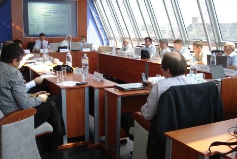
16 Warsaw 2002 Sofia 2002 Riga 2003 Berlin 2003 Bratislava 2004 Sofia 2004 Prague 2005 Berlin 2005 Warsaw 2006 Budapest 2006 Riga 2007 Vilnius 2007 Bucharest 2008 Berlin 2008 Tallinn 2009 Berlin 2009 Novy Sad 2010 Warsaw 2010 Budapest 2011 Berlin 2011 Bratislava 2012 Bucharest 2012 Tbilisi 2013 Berlin 2013 Riga 2014 Warsaw 2014 Chisinau 2015 Prague 2016 Bratislava 2017 Tallinn 2018 EUPOS MEETINGS PARTICIPANTS EVOLUTION ( ) Participants Countries 0 29 meetings Average numbers: 19 participants / 11 countries


17 EUPOS WEB PAGE, EUPOS OFFICE Web page Administrator: Szymon Wajda EUPOS Office - no official EUPOS address - virtual address via EUPOS web page (Contact item) and office@eupos.org People responsible for EUPOS tasks: - EUPOS chairman - EUPOS vice-chairman - EUPOS Executive board members 17
 - head: Ambrus Kenyeres - Aim: EUPOS combination of countries SINEX")
 - head: Karol Smolík - Aim: common monitoring of countries network RTK solution - http://monitoringeupos.")
18 EUPOS WORKING GROUPS EUPOS WG on system quality, integrity and interference monitoring (SQII) - head: Janis Zvirgzds - aim: solving EUPOS certification for each service/network EUPOS Combination Center WG (ECC) - head: Ambrus Kenyeres - Aim: EUPOS combination of countries SINEX solutions, coordinates monitoring and estimation of the velocity fields - Activity transform to EUREF densification project EUPOS WG on service quality monitoring (SGM) - head: Karol Smolík - Aim: common monitoring of countries network RTK solution
19 EUPOS DOCUMENTS GUIDELINES AND STANDARDS EUPOS Terms of Reference EUPOS Technical Standards EUPOS Guideline for Single Site Design EUPOS Guideline for Cross-Border Data Exchange 19
20 EUPOS TECHNICAL ISSUES EUPOS technical standards Structure of the network Equipment and settings Quality measures User interface EUPOS services DGNSS for RT positioning and navigation, accuracy 2m 0.5m for moving objects and 0.2m for static Network RTK for precise RT positioning - 2 cm Geodetic, post-processing 1 cm and better Data streams transmitted via Internet NTRIP technology, RTCM SC104 format Additionally radio or TV VHF broadcasting System availability on the level of at least 99% Availability upgrade up to 99.9% is realistic 20


21 EUPOS = GALILEO POSITIVE In EUPOS technical standards EUPOS was designed... to support multi-constellation GNSS.... Taking into account political and geographical associations, the primary GNSS constellation...is European system Galileo. 21
22 ACHIEVEMENTS AND CHALLENGES Achievements Incentive to building up CORS networks in member countries System of standards and guidelines Outreach activities collaboration with international organizations and bodies EUPOS symposia (impact on professionals from different fields of activities) 2005, 2008, 2009 (Berlin), 2010 (Brussels), 2011 (Berlin) EUPOS in international programs and projects Challenges EUPOS via members disposes with a large observation data and product volume which represents a potential that can benefit a number of activities, among others in science: Reference frames, velocities Ground based meteorology Geodynamics, neotectonics Space weather, upper atmosphere studies Gravity field modelling 22
23 SOME TOPICS RECENTLY DISCUSSED WITHIN EUPOS Some topics recently discussed within EUPOS technical meetings Experience with Network RTK measurements with Galileo GNSS signal interference Cooperation with private permanent networks GNSS metrology especially for user rovers verification, validation, calibration,... Common standard or Guideline for RTK/Network RTK surveying 23
 32 participants / 18")
24 EUPOS 2017 BRATISLAVA MEETING 4 th EUPOS council (only for members) and technical meeting (members + invited) 32 participants / 18 countries
25 EUPOS 2017 BRATISLAVA MEETING MAIN TOPICS Country reports were focused on: GNSS network infrastructure (status + news + ready for Galileo) GNSS metrology how is it solve in each country Existence of Guidelines for users for RTK network surveying GNSS permanent station protection status in each country EUPOS Technical standards fulfilment GNSS (RTK network) infrastructure software status (invited representatives from Trimble, Leica and Geo++): Current status + news Galileo ready and restrictions Third party receivers support EUPOS WG status, Galileo status (GSA), Antenna calibration robot (Geo++) EUREF (Kenyeres) and RTCM news (Wubbena)


26 EUPOS 2017 BRATISLAVA MEETING MAIN TOPICS - RESULTS GNSS metrology for rovers Czech version calibration baseline Hungarian version static measurement Existence of Guidelines for users for RTK network surveying Special guideline exists only in Slovakia In other countries different type of instructions, information instead of solo guideline GNSS permanent station protection Physically ensured, legislative nowhere
27 EUPOS 2017 BRATISLAVA MEETING MAIN TOPICS - RESULTS GNSS (RTK network) infrastructure software status all companies prepared for Galileo and all GNSS and their frequencies each company has its own solution how to handle increasing number of satellites and frequencies to reduce processing time Antenna calibration robot calibration robot will be able to compute PCV for Galileo in near future More results from presentations available on meeting web page:

28 EUPOS 2018 TALLIN MEETING 5 th EUPOS council and technical meeting was held in November 2018 in Tallinn 24 participants / 10 countries
29 EUPOS 2018 TALLINN MEETING MAIN TOPICS Country reports were focused on: GNSS network infrastructure status + news Galileo readiness Experience with signal jamming, interference, Experience with mixture of hardware brands Users feedback - most criticized issues Experience with Network RTK measurements with Galileo (invited representatives from the Netherlands, Sweden) GNSS signal interference by radio amateurs (Austria experience) Problematic CORS HW/monumentation detection (Slovakia) Double stations and network densification experience (Sweden) CLGE needs for GNSS RTK service operators (Kakko)
30 EUPOS 2018 TALLINN MEETING MAIN TOPICS - RESULTS Experience with Network RTK measurements with Galileo Implementation of Galileo in Sweden (2016) does not show and great improvement we have to wait GNSS signal interference by radio amateurs It was recognised in Austria (APOS stations) L2 GLONASS frequency was affected Solution: radio amateurs switched from UHF 32 cm to different frequency New Septentrio receivers with adoptive filter were not affected Problematic CORS HW/monumentation detection life time of GNSS antennas caused degradation of stations coordinates time series some antennas need to be changed every 10 years
31 EUPOS 2019 MEETING The nearest meeting will be held in autumn 2019 in Budapest Host organization: Satellite geodetic observatory Penc Topics under preparation: Members networks news, status Experience with Galileo jamming, interference EPSG standards.
32 THANK YOU FOR YOUR ATTENTION Dr. Branislav Droščák
EUPOS European Position Determination System
 EUPOS European Position Determination System c/o Senate Department for Urban Development, State Berlin, Germany Umea, Sweden, 22 nd 23 rd 2011 The Geodetic Infrastructure in Europe today and tomorrow Slide
EUPOS: Unified GNSS Augmentation Infrastructure and International Cooperation in Central and Eastern Europe
 EUPOS: Unified GNSS Augmentation Infrastructure and International Cooperation in Central and Eastern Europe Senate Department for Urban Development Geodetic Reference Systems Fehrbelliner Platz 1, 10707
European Position Determination System (EUPOS )
") European Position Determination System (EUPOS ) Georgi MILEV, Bulgaria, Gerd ROSENTHAL, Germany and Keranka VASSILEVA, Bulgaria Key words: ABSTRACT The project EUPOS is an initiative to establish a uniform
European Position Determination System (EUPOS ) Georgi MILEV, Bulgaria, Gerd ROSENTHAL, Germany and Keranka VASSILEVA, Bulgaria Key words: ABSTRACT The project EUPOS is an initiative to establish a uniform
EUPOS - European Position Determination System Status and current issues
 EUPOS - European Position Determination System Status and current issues Office of the International EUPOS Steering Committee Senate Department for Urban Development, Land Berlin, Germany Symposium of
Monitoring tool for EUPOS countries network RTK quality
 Monitoring tool for EUPOS countries network RTK quality Dr. Branislav Droščák & Karol Smolík Geodetic and Cartographic Institute BRATISLAVA EUPOS WG on Service Quality Monitoring branislav.droscak@skgeodesy.sk,
EUPOS Central and Eastern European Differential (D)GNSS Infrastructure, and Cooperation
GNSS Infrastructure, and Cooperation") EUPOS Central and Eastern European Differential (D)GNSS Infrastructure, and Cooperation Office of the International EUPOS Steering Committee, Head Senate Department for Urban Development, State of Berlin,
EUPOS Central and Eastern European Differential (D)GNSS Infrastructure, and Cooperation Office of the International EUPOS Steering Committee, Head Senate Department for Urban Development, State of Berlin,
CONTRIBUTION OF EUPOS PERMANENT GPS NETWORK TO THE EUREF REFERENCE SYSTEM
 BERLIN SENATE, DEPARTMENT FOR URBAN DEVELOPMENT, GERMANY HEAD OFFICE OF GEODESY AND CARTOGRAPHY, WARSAW, POLAND FÖMI SATELLITE GEODETIC OBSERVATORY PENC, HUNGARY WARSAW UNIVERSITY OF TECHNOLOGY INSTITUTE
EUPOS the success guarantee for rapid buildup the infrastructure in the countries of Central and Eastern Europe
 EUPOS the success guarantee for rapid buildup the infrastructure in the countries of Central and Eastern Europe Dr. Ivo Milev Representative of the International EUPOS Steering Committee Contact: Dr. Ivo
EUROPEAN POSITION DETERMINATION SYSTEM (EUPOS )
") 1 EUROPEAN POSITION DETERMINATION SYSTEM (EUPOS ) G. ROSENTHAL 1, G. MILEV 2, K. VASSILEVA 2 EUPOS: European Position Determination System 1. General 2. For position fixing with higher accuracy many countries
1 EUROPEAN POSITION DETERMINATION SYSTEM (EUPOS ) G. ROSENTHAL 1, G. MILEV 2, K. VASSILEVA 2 EUPOS: European Position Determination System 1. General 2. For position fixing with higher accuracy many countries
PosKEN Related Activities in the Czech Republic
 Research Institute of Geodesy, Topography, and Cartography Geodetic Observatory Pecny Land Survey Office, Prague PosKEN Related Activities in the Czech Republic 2014-2015 National Report J. Šimek 1 and
European Position Determination System. Technical Standards
 European Position Determination System Technical Standards Revised 2 nd Edition 24 April 2008 Resolution of the International EUPOS Steering Committee 13 th Conference, Bucharest, Romania, 23 24 April
ASG-EUPOS reference system
 Head Office of Geodesy and Cartography Department of Geodesy, Cartography and GIS ASG-EUPOS reference system Last year activities and future plans Szymon Wajda Prime specialist Bratislava, 21-22.11.2017
Towards a EUREF Service Providing Real-time GNSS Clock and Orbit Corrections
 Towards a EUREF Service Providing Real-time GNSS Clock and Orbit Corrections G. Weber 1), W. Söhne 1), A. Stürze 1), L. Mervart 2) 1) Federal Agency for Cartography and Geodesy, Frankfurt am Main, Germany
Real-Time GNSS EUREF-IP Pilot Project
 Real-Time GNSS EUREF-IP Pilot Project G. Weber, BKG, Frankfurt 1. Status: Network, coverage, contributors 2. White Paper: Real-time GNSS in Routine EPN Operations 3. Real-time GNSS tools: BNC, client for
ASG-EUPOS DENSIFICATION OF EUREF PERMANENT NETWORK ON THE TERRITORY OF POLAND
 ASG-EUPOS DENSIFICATION OF EUREF PERMANENT NETWORK ON THE TERRITORY OF POLAND 1. INTRODUCTION Jarosław Bosy 1,2) Artur Oruba 1) Wieslaw Graszka 1) Marcin Leonczyk 1) Marcin Ryczywolski 1) 1) Head Office
Alberding solutions for GNSS infrastructure operators
 Tamás Horváth Alberding solutions for GNSS infrastructure operators 21.11.2017 1/35 Alberding solutions for GNSS infrastructure operators Tamás Horváth Alberding GmbH 4 th EUPOS Technical Meeting 21-22
LitPOS a part of EUPOS
 Project part-financed by the European Union LitPOS a part of EUPOS Eimuntas Parseliunas 1, Arunas Buga 1, Leonardas Marozas 1, Marius Petniunas 1, Saulius Urbanas 2 Abstract 1 Institute of Geodesy, Vilnius
ROMPOS FOR CADASTRE APPLICATIONS
 International Symposium on Global Navigation Satellite Systems, Space-Based and Ground-Based Augmentation Systems and Applications 2009; Berlin, Germany, 30 November - 2 December 2009 ROMPOS FOR CADASTRE
Real-time PPP Results From Global Orbit and Clock Corrections
 BKG, Frankfurt a.m. Real-time PPP Results From Global Orbit and Clock Corrections Yüksel Altiner 1, Leos Mervart 2, Peter Neumaier 1, Wolfgang Söhne 1, Georg Weber 1 1 Federal Agency for Cartography and
EUREF Related Activities in the Czech Republic
 Research Institute of Geodesy, Topography, and Cartography Geodetic Observatory Pecny Land Survey Office, Prague EUREF Related Activities in the Czech Republic 2014-2015 National Report J. Douša 1, V.
Cross-Border EUPOS Data Exchange First Experience
 Cross-Border EUPOS Data Exchange First Experience Eimuntas Paršeliūnas, Marius Petniūnas, Domantas Bručas (Institute of Geodesy of Vilnius Gediminas Technical University, Lithuania) Wieslaw Graszka (Head
SKPOS. Slovak real-time positioning service - a multifunctional tool for precise object and phenomena positioning
 SKPOS Slovak real-time positioning service - a multifunctional tool for precise object and phenomena positioning WHAT IS SKPOS AND HOW DOES IT WORK? Slovak real-time positioning service is a multifunctional
HEAD OFFICE OF GEODESY AND CARTOGRAPHY. Wspolna 2 Str., Warsaw, Poland ASG-EUPOS THE POLISH CONTRIBUTION TO THE EUPOS PROJECT
 HEAD OFFICE OF GEODESY AND CARTOGRAPHY Wspolna 2 Str., 00-926 Warsaw, Poland ASG-EUPOS THE POLISH CONTRIBUTION TO THE EUPOS PROJECT Project Part-Financed by European Union European Regional Development
SKPOS NOT ONLY POSITIONING SERVICE R&D PROJECTS SUPPORTER
 SKPOS NOT ONLY POSITIONING SERVICE R&D PROJECTS SUPPORTER Ing. Branislav Droščák, PhD. Geodetic and Cartographic Institute BRATISLAVA branislav.droscak@skgeodesy.sk International scientific and methodological
EUREF Related Activities in the Czech Republic
 Research Institute of Geodesy, Topography, and Cartography Geodetic Observatory Pecny Land Survey Office, Prague EUREF Related Activities in the Czech Republic 2012-2013 National Report J. Šimek 1, J.
EVC from the launch till now programme and activities in
 Mutual Learning Workshop: Strategic Intelligence for Extended Regional Coherence Eurasian Virtual Center for Foresight 2.0 EVC from the launch till now programme and activities in 2006-2011 Tatiana Chernyavskaya
Integrated geodetic infrastructure at the Geodetic Observatory Pecný, Czech Republic, in service of national and international GNSS projects
 Integrated geodetic infrastructure at the Geodetic Observatory Pecný, Czech Republic, in service of national and international GNSS projects Pavel NOVÁK, Czech Republic Key words: geodesy, reference systems,
NTRIP Background History, Development & BKG. Networked Transport of RTCM via Internet Protocol
 Networked Transport of RTCM via Internet Protocol Networked Transport of RTCM via Internet Protocol Bundesamt für Kartographie und Geodäsie Motivation: Use Internet to transport GNSS corrections Communication
EUREF Permanent GNSS Network Carine Royal Observatory of Belgium
 ENEON first workshop Observing Europe: Networking the Earth Observation Networks in Europe EUREF Permanent GNSS Network Carine Bruyninx/C.Bruyninx@oma.be Royal Observatory of Belgium 1. About your network
Newsletter 01/2012. Content
 Newsletter 01/2012 Content Ten years of establishment of EUPOS reference stations in Central and Eastern Europe Some words about the International GNSS Symposium 2011, Berlin, Germany EUPOS news from HUNGARY
The 3 rd generation SWEPOS TM network - towards a modern GNSS reference station infrastructure
 The 3 rd generation SWEPOS TM network - towards a modern GNSS reference station infrastructure Lars Jämtnäs, Johan Sunna and Bo Jonsson Johan Sunna, 2010-09-28, Sundvolden hotel Table of contents Introduction
Global and Regional Real-Time Infrastructure for open access use
 Global and Regional Real-Time Infrastructure for open access use Axel Rülke Federal Agency for Cartography and Geodesy Branch Office Leipzig, Germany Tutorial on (Open) Real-Time Infrastructure and Applications
EUREF Related Activities in the Czech Republic
 Research Institute of Geodesy, Topography, and Cartography Geodetic Observatory Pecny Land Survey Office, Prague EUREF Related Activities in the Czech Republic 2015-2016 National Report J. Douša 1, V.
5.0% 0.0% -5.0% -10.0% -15.0% 10.0% 5.0% 0.0% -5.0% -10.0% -15.0% 10.0% 5.0% 0.0% -5.0% -10.0% 16.00% 13.00% 10.00% 7.00% 4.
 MARKETBEAT The DNA of Real Estate EUROPE A Cushman & Wakefield Research Publication Q4 2014 ICE RENTAL (YEAR-ON-YEAR) Q4 2012 Q4 2013 Q4 2014 All Countries 0.2% 0.7% 0.2% Western Europe -0.5% 0.7% 1.8%
Galileo and the future of SatNav: monitoring the market and technology opportunities
 Galileo and the future of SatNav: monitoring the market and technology opportunities Alberto Fernández Wyttenbach, Market Innovation Officer ESA Space Moves! 18 th September 2017, Berlin GSA governance
EUREF Related Activities
 Symposium of the IAG Subcommission for Europe (EUREF) Chisinau, Moldova, 25 28 May, 2011 National Report of the Czech Republic EUREF Related Activities in the Czech Republic 2010-2011 National Report presented
National report of Finland
 National report of Finland Matti Ollikainen, Jorma Jokela, Markku Poutanen, Ruizhi Chen and Jaakko Mäkinen, Finnish Geodetic Institute, P.O.Box 15, 02431 Masala, Finland EUREF Symposium 2006, June 14-17,
SSR Technology for Scalable Real-Time GNSS Applications
 SSR Technology for Scalable Real-Time GNSS Applications Gerhard Wübbena, Jannes Wübbena, Temmo Wübbena, Martin Schmitz Geo++ GmbH 30827 Garbsen, Germany www.geopp.de Abstract SSR Technology for scalable
Tamás Horváth. 06 June 2012
 Tamás Horváth Software solutions for GNSS infrastructure monitoring 06 June 2012 1/18 Software solutions for GNSS infrastructure monitoring Tamás Horváth Alberding GmbH 06 June 2012 Tamás Horváth Software
Template for CORS Networks
 Template for CORS Networks This template gives an idea on what can be included in the document or poster to describe the national or regional CORs network that your organisation is responsible for. The
SSR & RTCM Current Status
 SSR & RTCM Current Status Gerhard Wübbena, Martin Schmitz, Jannes Wübbena Geo++ GmbH 30827 Garbsen, Germany www.geopp.de Outline RTCM SC104 WG s SSR Today SSR Formats SC104 RTCM-SSR Geo++ RTCM 4090 SSR
Implementation of New Positioning System in Riga
 Implementation of New Positioning System in Riga M.Abele (1), J.Balodis (1), K.Balodis (1), M.Caunite (1), I.Janpaule (1), A.Rubans (1), G.Silabriedis (1,2), I.Mitrofanovs(2), A.arinsjh (1) (1) University
Some Features of Pre-Processing of RTK Network LitPos (Lithuania) Data Applying Bernese Software
 Data Applying Bernese Software") Environmental Engineering 10th International Conference eissn 2029-7092 / eisbn 978-609-476-044-0 Vilnius Gediminas Technical University Lithuania, 27 28 April 2017 Article ID: enviro.2017.160 http://enviro.vgtu.lt
Environmental Engineering 10th International Conference eissn 2029-7092 / eisbn 978-609-476-044-0 Vilnius Gediminas Technical University Lithuania, 27 28 April 2017 Article ID: enviro.2017.160 http://enviro.vgtu.lt
SUPPORT OF NETWORK FORMATS BY TRIMBLE GPSNET NETWORK RTK SOLUTION
 SUPPORT OF NETWORK FORMATS BY TRIMBLE GPSNET NETWORK RTK SOLUTION TRIMBLE TERRASAT GMBH, HARINGSTRASSE 19, 85635 HOEHENKIRCHEN, GERMANY STATUS The Trimble GPSNet network RTK solution was first introduced
Innovative Solutions for Applied Communications in O&G
 / 03-2014 Innovative Solutions for Applied Communications in O&G Page 1 siemens.com/convergence-creators , Where we are Worldwide activities with a solid presence in Europe USA Los Angeles Czech Praha
Geoscience & Positioning, Navigation and Timing Services for Canadians
 Geoscience & Positioning, Navigation and Timing Services for Canadians Calvin Klatt, Ph.D. Director and Chief Geodesist Natural Resources Canada / Directeur et géodésien principal Ressources naturelles
New era for Eureka - relations with ETPs
 New era for Eureka - relations with ETPs Dr. Aleš Mihelič EUREKA Chairman Slovenian EUREKA Chair 07/08 The past is history Established in 1985 An initiative of French President Mitterand and German Chancellor
THE INTERNATIONALIZATION OF CORPORATE R&D AND THE DEVELOPMENT OF AUTOMOTIVE R&D IN EAST-CENTRAL EUROPE
 THE INTERNATIONALIZATION OF CORPORATE R&D AND THE DEVELOPMENT OF AUTOMOTIVE R&D IN EAST-CENTRAL EUROPE Petr Pavlínek University of Nebraska at Omaha, USA Charles University in Prague, Czechia CHANGING
One Source for Positioning Success
 novatel.com One Source for Positioning Success RTK, PPP, SBAS OR DGNSS. NOVATEL CORRECT OPTIMIZES ALL CORRECTION SOURCES, PUTTING MORE POWER, FLEXIBILITY AND CONTROL IN YOUR HANDS. NovAtel CORRECT is the
The International Scene: How Precise Positioning Will Underpin Critical GNSS Applications
 The International Scene: How Precise Positioning Will Underpin Critical GNSS Applications School of Civil & Environmental Engineering, UNSW, Sydney, Australia Chris Rizos Member of the IGS Governing Board
The status of the European Roller in Lithuania
 The status of the European Roller in Lithuania Do you have breeding rollers in your country? Yes Update Migration - Yes (Latvian ringed rollers observations, observation of passengers during migration
Pre-Commercial Procurement (PCP) Actions
 Actions") Pre-Commercial Procurement (PCP) Actions Open call in Objective 11.1 Targeted Calls in objectives 5.1(d), 11.2, 11.3, 8.2, 5.1(e)(1), 2.2(b) lieve.bos@ec.europa.eu EU Commission, DG INFSO Lisbon policy
Pre-Commercial Procurement (PCP) Actions Open call in Objective 11.1 Targeted Calls in objectives 5.1(d), 11.2, 11.3, 8.2, 5.1(e)(1), 2.2(b) lieve.bos@ec.europa.eu EU Commission, DG INFSO Lisbon policy
EUREF Related Activities in the Czech Republic
 Research Institute of Geodesy, Topography, and Cartography Geodetic Observatory Pecny Land Survey Office, Prague EUREF Related Activities in the Czech Republic 2011-2012 National Report J. Šimek1, J. Douša1,
Comparative analysis of GNSS Real Time Kinematic methods for navigation
 IAV Hassan II Comparative analysis of GNSS Real Time Kinematic methods for navigation Mourad BOUZIANI School of Geomatic Sciences, IAV Hassan II, Rabat, Morocco. Coordinator of the Master - GNSS, IAV&
Centralised Services 7-2 Network Infrastructure Performance Monitoring and Analysis Service
 EUROCONTROL Centralised Services 7-2 Network Infrastructure Performance Monitoring and Analysis Service Monitoring the performance of 1030/1090 MHz RF bands A COST-EFFICIENT SOLUTION To make best use of
Geodetic policy for Ireland and Northern Ireland
 Geodetic policy for Ireland and Northern Ireland Background Ordnance Survey Ireland (OSi) is the National Mapping Agency (NMA) of the Republic of Ireland. The Ordnance Survey of Northern Ireland (OSNI)
SatNav and SatCom Interfaces with GMES
 SatNav and SatCom Interfaces with GMES Head of Digital Dr. Sandro Scalise (DLR) Digital Networks Section DLR Inst. of Communications and Navigation Chairman of ISI R&D Working Group contact: Sandro.Scalise@dlr.de
Role of Manufacturers to support Geodetic Infrastructure
 FIG / UN-GGIM-AP / JUPEM Geospatial and GNSS CORS Infrastructure Forum Kuala Lumpur, Malaysia 16-17 Oct 2016 Role of Manufacturers to support Geodetic Infrastructure Neil Ashcroft Leica Geosystems Information
United Nations/Moldova/United States of America Workshop on the Applications of Global Navigation Satellite Systems. Chisinau, Moldova, May 2010
 United Nations/Moldova/United States of America Workshop on the Applications of Global Navigation Satellite Systems Chisinau, Moldova, 17 21 May 2010 PROGRAMME Monday, 17 May 2010 08:00 Registration of
National Report of Greece to EUREF 2014
 National Report of Greece to EUREF M. Gianniou, D. Mastoris, E. Mitropoulou National Cadastre and Mapping Agency S.A. Mesogion Ave., Athens, Greece. Introduction During the last months the main activities
MARKETBEAT THE DNA OF REAL ESTATE EUROPE Q A Cushman & Wakefield Research Publication OFFICE RENTAL GROWTH (YEAR-ON-YEAR)
") MARKETBEAT THE DNA OF REAL ESTATE EUROPE A Cushman & Wakefield Research Publication Q2 2015 ICE RENTAL GROWTH (YEAR-ON-YEAR) Q2 2013 Q2 2014 Q2 2015 All Countries 0.4% 0.9% 0.4% Western Europe 0.2% 1.3%
MARKETBEAT THE DNA OF REAL ESTATE EUROPE A Cushman & Wakefield Research Publication Q2 2015 ICE RENTAL GROWTH (YEAR-ON-YEAR) Q2 2013 Q2 2014 Q2 2015 All Countries 0.4% 0.9% 0.4% Western Europe 0.2% 1.3%
Economic crisis, European Welfare State Models and Inequality
 Economic crisis, European Welfare State Models and Inequality Carlos Ochando Claramunt Department of Applied Economics, University of Valencia (Spain) Carlos.Ochando@uv.es Paper presented to XIII International
Real-Time and Multi-GNSS Key Projects of the International GNSS Service
 Real-Time and Multi-GNSS Key Projects of the International GNSS Service Urs Hugentobler, Chris Rizos, Mark Caissy, Georg Weber, Oliver Montenbruck, Ruth Neilan EUREF 2013 Symposium Budapest, Hungary, May
Precise Positioning GNSS Applications
 Precise Point Positioning: Is the Era of Differential GNSS Positioning Drawing to an End? School of Surveying & Spatial Information Systems, UNSW, Sydney, Australia Chris Rizos 1, Volker Janssen 2, Craig
LATVIA POSITIONING SYSTEM BASE STATION INSTALLATION IN VALKA
 LATVIA POSITIONING SYSTEM BASE STATION INSTALLATION IN VALKA A. Celms 1, E. Eglāja 2, A. Ratkevičs 3 1 Armands Celms, Latvia University of Agriculture, armands.celms@llu.lv; 2 Elita Eglāja, Latvia University
General Assembly. United Nations A/AC.105/946
 United Nations A/AC.105/946 General Assembly Distr.: General 16 November 2009 Original: English Committee on the Peaceful Uses of Outer Space Report on the United Nations/Azerbaijan/United States of America/European
EU businesses go digital: Opportunities, outcomes and uptake
 Digital Transformation Scoreboard 2018 EU businesses go digital: Opportunities, outcomes and uptake February 2018 Internal Market, Industry, Entrepreneurship and SMEs Executive summary Conditions and outcomes
The Reasons to Succeed or to Fail a GNSS Network RTK Project
 The Reasons to Succeed or to Fail a GNSS Network RTK Project Joël van Cranenbroeck, Managing Director CGEOS Creative Geosensing sprl-s, Belgium Andy Yin, International Sales Director ComNav Technology
DYNAMIC RT TECHNOLOGY
 DYNAMIC RT TECHNOLOGY GLOBAL NAVIGATION SATELLITE SYSTEMS (GNSS) POTENTIAL FUTURE DEVELOPMENTS(2005 2017?) GPS MODERNIZATION BLOCK IIF & III GLONASS ENHANCEMENTS (K & M) EUROPEAN UNION - GALILEO CHINA
Eurovision Song Contest 2011
 Eurovision Song Contest 2011 Annex with detailed illustration of the 15-day spectrum recording Seite 50 von 81 Evaluation of the 1 th day of the DKE spectrum recording: 01.05.2011 Maximum values of the
Trimble NetR9 Reference Receiver Series: Frequently Asked Questions
 July 2010 Trimble NetR9 Reference Receiver Series: Frequently Asked Questions What is the Trimble NetR9 GNSS reference receiver? The Trimble NetR9 GNSS (Global Navigation Satellite System) reference receiver
Tersus RTK Competitive Analysis
 Test Report Jun 2018 Tersus RTK Competitive Analysis 2018 Tersus GNSS Inc. All rights reserved. Sales & Technical Support: sales@tersus-gnss.com & support@tersus-gnss.com More details, please visit www.tersus-gnss.com
GNSS signal interference detection in LatPos base stations
 GNSS signal interference detection in LatPos base stations Dr.sc.ing. Jānis Zvirgzds LGIA GNSS Pernament base station division PhD. Didzis Dobelis LGIA GNSS Pernament base station division EUROPEAN SPACE
Munkaanyag
 TECHNICAL SPECIFICATION SPÉCIFICATION TECHNIQUE TECHNISCHE SPEZIFIKATION CEN/TS 16555-6 December 2014 ICS 03.100.40; 03.100.50 English Version Innovation management - Part 6: Creativity management Management
Hi! I m Heather. Enjoy the printable pack!
 Hi! I m Heather. I am a homeschooling mother of four wild and little kiddos, and I blog over at Only Passionate Curiosity. On my blog, I try to share a little bit of what our homeschool life is like, all
Leica GRX1200+ Series High Performance GNSS Reference Receivers
 Leica GRX1200+ Series High Performance GNSS Reference Receivers Leica GRX1200+ Series For permanent reference stations The Leica GRX1200+ Series, part of Leica's future proof System 1200, is designed specifically
Economic and Social Council
 United Nations Economic and Social Council ECE/CES/GE.41/2013/3 Distr.: General 15 August 2013 Original: English Economic Commission for Europe Conference of European Statisticians Group of Experts on
EU Ecolabel EMAS Environmental Technology Verification (ETV) State-of-play and evaluations
 State-of-play and evaluations") EU Ecolabel EMAS Environmental Technology Verification (ETV) State-of-play and evaluations Pierre Henry DG Environment B1 3 instruments of Circular Economy action plan Improving the efficiency and uptake
EU Ecolabel EMAS Environmental Technology Verification (ETV) State-of-play and evaluations Pierre Henry DG Environment B1 3 instruments of Circular Economy action plan Improving the efficiency and uptake
Report on the United Nations/Croatia Workshop on the Applications of Global Navigation Satellite Systems
 United Nations General Assembly Distr.: General 3 September 2013 Original: English Committee on the Peaceful Uses of Outer Space Report on the United Nations/Croatia Workshop on the Applications of Global
TECHNICAL PROFILES CATALOGUE 2016
 TECHNICAL PROFILES CATALOGUE 2016 ULTIMATE PROFILE SOLUTIONS Table of Contents: I. FILTER FRAME PRofIles...........................9 AP 669................................................... 9 AP 591...................................................
National Census Geography Some lessons learned and future challenges in European countries
 UNSD-AITRS Regional Workshop on the Integration of Statistical and Geospatial Information Amman, Jordan, 16-20 February, 2015 National Census Geography Some lessons learned and future challenges in European
S. Silin, A. Muravyev Design Bureau of Navigation Systems (NAVIS Inc.)
") S. Silin, A. Muravyev Design Bureau of Navigation Systems (NAVIS Inc.) ICG-11, Sochi, Russia, 6-11 November 2016 GNSS Interoperability Solution Issues of GNSS interoperability at the user level can be
S. Silin, A. Muravyev Design Bureau of Navigation Systems (NAVIS Inc.) ICG-11, Sochi, Russia, 6-11 November 2016 GNSS Interoperability Solution Issues of GNSS interoperability at the user level can be
NFC Forum: The Evolution of a Consortium
 NFC Forum: The Evolution of a Consortium Presented by Greg Kohn Sr. Operations Director, NFC Forum ANSI Open Forum: Building Bridges across the Standards Ecosystem October 9, 2012 Part of the World Standards
Presented at the FIG Working Week 2017, May 29 - June 2, 2017 in Helsinki, Finland
 Presented at the FIG Working Week 2017, May 29 - June 2, 2017 in Helsinki, Finland FIG Working Week 2017 European GNSS for Surveying and Mapping Reinhard Blasi, Alina Hriscu Market Development, European
The Role of F.I.G. in Leading the Development of International Real-Time Positioning Guidelines
 The Role of F.I.G. in Leading the Development of International Real-Time Positioning Guidelines, USA Key Words: RTN, real-time, GNSS, Guidelines SUMMARY The rapid growth of real-time reference station
EMERGING METHODOLIGES FOR THE CENSUS IN THE UNECE REGION
 United Nations International Seminar on Population and Housing Censuses: Beyond the 2010 Round 27-29 November 2012 Seoul, Republic of Korea SESSION 4: Emerging methodologies for the census EMERGING METHODOLIGES
IMO WORLDWIDE RADIONAVIGATION SYSTEM (WWRNS) Study on Communication Techniques for High Accuracy DGPS in the Republic of Korea
 Study on Communication Techniques for High Accuracy DGPS in the Republic of Korea") INTERNATIONAL MARITIME ORGANIZATION E IMO SUB-COMMITTEE ON SAFETY OF NAVIGATION 52nd session Agenda item 12 NAV 52/INF.8 12 May 2006 ENGLISH ONLY WORLDWIDE RADIONAVIGATION SYSTEM (WWRNS) Study on Communication
INTERNATIONAL MARITIME ORGANIZATION E IMO SUB-COMMITTEE ON SAFETY OF NAVIGATION 52nd session Agenda item 12 NAV 52/INF.8 12 May 2006 ENGLISH ONLY WORLDWIDE RADIONAVIGATION SYSTEM (WWRNS) Study on Communication
Quasi-Zenith Satellite System (QZSS)
") Transmission of Augmentation Corrections using the Japanese QZSS for Real-Time Precise Point Positioning in Australia Ken Harima 1, Suelynn Choy 1, Mazher Choudhury 2, Chris Rizos 2, Satoshi Kogure 3 1
Transmission of Augmentation Corrections using the Japanese QZSS for Real-Time Precise Point Positioning in Australia Ken Harima 1, Suelynn Choy 1, Mazher Choudhury 2, Chris Rizos 2, Satoshi Kogure 3 1
The role of EGNOS in the recapitalised DGNSS service of WSV - concept and implementation
 The role of EGNOS in the recapitalised DGNSS service of WSV - concept and implementation Tamás Horváth 1, Michael Hoppe 2 1 Alberding GmbH 2 German Federal Waterways and Shipping Administration (WSV) EGNOS
CROPOS as Support of Geodetic Infrastructure in Croatia
 CROPOS as Support of Geodetic Infrastructure in Croatia Dr. Sc. Danko Markovinović - Croatia CLGE VicePresident The Geodetic Infrastructure in Europe - today and tomorrow Sweden...Umeå...22-23 June 2011
Ready for RED. Radio Equipment Directive Introduction. / RED. Christian Reimer
 Ready for RED Radio Equipment Directive Introduction www.rohde-schwarz.com / RED Christian Reimer Essential Requirements of Radio Equipment Directive Radio equipment shall be so constructed that it both
Terrestrial Reference Frame of Serbia and its temporal rate
 Belgrade University Faculty of Civil Engineering Terrestrial Reference Frame of Serbia and its temporal rate Sofija Naod, Sanja Grekulović, Violeta Vasilić Oleg Odalović, Dragan Blagojević Department of
1ST GALILEO USER ASSEMBLY USER CONSULTATION PLATFORM - SURVEYING Meeting Date Time 10:15-16:30 Meeting Called By GSA Location Madrid - INTA
 1ST GALILEO USER ASSEMBLY USER CONSULTATION PLATFORM - SURVEYING Meeting Date 28.11.2017 Time 10:15-16:30 Meeting Called By GSA Location Madrid - INTA Minutes Taken By Attendees Elena Megias, Telespazio
Group of Administrative Co-operation Under the R&TTE Directive. 5 th R&TTE Market Surveillance Campaign on WLAN 5 GHz
 Group of Administrative Co-operation Under the R&TTE Directive Ref. Ares(2015)1723904-23/04/2015 5 th R&TTE Market Surveillance Campaign on WLAN 5 GHz REPORT ON THE 5 TH JOINT CROSS-BORDER R&TTE MARKET
VIIIth European Interparliamentary Space. Mr. Rainer Grohe Executive Director Galileo Joint Undertaking
 The European Institutional Framework for Galileo VIIIth European Interparliamentary Space Conference Mr. Rainer Grohe Executive Director Galileo Joint Undertaking Brussels, 12th June 2006 Galileo Architecture
KOPOS (KOsovo POsitioning System) ANALYSIS IN THE TESTING PHASE
 ANALYSIS IN THE TESTING PHASE") KOPOS (KOsovo POsitioning System) ANALYSIS IN THE TESTING PHASE Murat Meha Muzafer Çaka Reshat Murati 3 CROPOS Conference, Opatija, 24-25 October 2013 1 Chronology of system development Owner of the system:
KOPOS (KOsovo POsitioning System) ANALYSIS IN THE TESTING PHASE Murat Meha Muzafer Çaka Reshat Murati 3 CROPOS Conference, Opatija, 24-25 October 2013 1 Chronology of system development Owner of the system:
SECTEUR Ascertaining user needs
 Ascertaining user needs Marta Bruno Soares (Uni Leeds), Maria Noguer (IEA), Nigel Arnell (Uni Reading), Jorge Paz (Tecnalia) and Amanda Hall (Telespazio VEGA UK) What is? «The Sector Engagement for the
Leica GRX1200 Series High Performance GNSS Reference Receivers
 Leica GRX1200 Series High Performance GNSS Reference Receivers Leica GRX1200 Series For permanent reference stations The Leica GRX1200 Series, part of Leica s new System 1200, is designed specifically
Status of the European Roller in LATVIA
 Status of the European Roller in LATVIA EDMUNDS RAČINSKIS, IEVA MĀRDEGA Hungary, 2017 Do we have breeding rollers in our country? Do we have breeding rollers in our country? (2) 1927-1970 Ringing data,
TWELFTH AIR NAVIGATION CONFERENCE
 AN-Conf/12-IP/20 4/10/12 TWELFTH AIR NAVIGATION CONFERENCE Montréal, 19 to 30 November 2012 Agenda Item 1: Strategic issues that address the challenge of integration, interoperability and harmonization