HEAD OFFICE OF GEODESY AND CARTOGRAPHY. Wspolna 2 Str., Warsaw, Poland ASG-EUPOS THE POLISH CONTRIBUTION TO THE EUPOS PROJECT
|
|
|
- Amy Carson
- 6 years ago
- Views:
Transcription


1 HEAD OFFICE OF GEODESY AND CARTOGRAPHY Wspolna 2 Str., Warsaw, Poland ASG-EUPOS THE POLISH CONTRIBUTION TO THE EUPOS PROJECT Project Part-Financed by European Union European Regional Development Fund Jaroslaw Bosy, Wiesław Graszka,Marcin Leonczyk Symposium on Global Navigation Satellite Systems Berlin, November 2008
2 CONTENTS 9 INTRODUCTION 9 EUPOS PROJECT 9 ASG-EUPOS DESCRIPTION 9 REALIZATION OF ASG-EUPOS 9 FUTURE PLANS 9 CONCLUSIONS 2/25
3 INTRODUCTION The goal of building of ASG-EUPOS system is to provide web-enable corrections for GNSS observations performed with satellite receivers and enabling the precise positioning and navigation in Poland. The ASG-EUPOS reference stations will create the geodetic control (reference) network according to the regulations of the act Geodetic and cartographic law from May 17th The ASG-EUPOS ground reference stations receiving signals from global navigation systems NAVSTAR GPS, GLONASS and GALILEO will constitute a system of spatial references in Poland The ASG-EUPOS multifunctional system for precise satellite positioning is a part of EUPOS project involving the countries of Central and Eastern Europe. 3/25

4 EUPOS PROJECT EUPOS (European Position Determination System) Multifunctional system for precise positioning and navigation purposes, 16 countries of Central and Eastern Europe participating, 429 reference stations developed, Unified technical standards used, Data from the border reference stations exchanged, ETRS89 system and national coordinate systems utilised, Whole system in 2008 completed. 4/25

5 ASG-EUPOS PROJECT 67 GPS stations built within the realised project, 8 GPS/GLONASS stations built within the realised, project 16 existing GPS reference stations situated in Poland, 3 existing GPS/GLONASS reference stations situated in Poland, about 30 foreign GNSS reference stations situated in the border zone, 2 management centres built in Warsaw and in Katowice, 13 spare verified localisation. 5/25
6 ASG-EUPOS PROJECT SERVICE METHOD DATA TRANSMISSION ACCURACY EQUIPMENT NAWGEO RTK GSM/ GPRS 0,03 m L1/L2 receivers Internet 0,05 m modem NAWGIS/ KODGIS DGPS FM/ VFM (opt.) GSM/ GPRS Internet 0,3 m 3,0 m L1 (CA) receivers L1/L2 receivers/ modem POZGEO/ POZGEO D Static Internet/ CDROM 0,01 m 0,1 m L1/L2 receivers L1 receivers 9 supply the 65 local geodetic offices with Rover GPS receivers, 9 establishing of technical support and information service, 9 maintenance of the ASG-EUPOS home page, 6/25
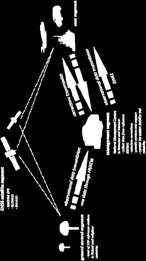
7 MANAGEMENT STRUCTURE INTERNATIONAL STEERING COMMITTEE /Coordination/ NATIONAL SERVICE CENTRES Integrity and Quality Monitoring Section / Certification/ GENERAL SURVEYOR OF POLAND Head Office of Geodesy and Cartography /Coordination and control/ NATIONAL SERVICE CENTRE The Centre for Geodesy and Cartography Documentation / Management, processing and servi ce/ REGIONAL MANAGEMENT CENTRE /Processing and service/ NATIONAL STEERING COMMITTE /Consultation/ SYSTEM USERS /Public administration, governmental agencies, science institutions/ /Enterprises and individuals/ Reference Station Network /GNSS observation collection/ TELECOMMUNICATIONS COMPANIES /Correction and data transmissi on/ International institutions National public agencies Private enterprises 7/25

8 PROJECT REALIZATION The ASG-EUPOS multifunctional precise positioning system project was realised utilising the resources of the European Regional Development Fund within the Operational Programme Improvement of the Competitiveness of Enterprises. Project co-financed by the EUROPEAN UNION European Regional Development Fund 8/25
9 PROJECT MILESTONES 9July 2004 agreement of ASG-EUPOS concept, 9September 2005 start of ASG-EUPOS project realization, 9 August 2006 public call for tender, 9 January 2007 signing the contract with consortium, 9 April 2007 establishment of NSC in Warsaw, 9 November 2007 development of new 75 stations, 9 December 2007 activation of RTK/DGPS services, 9 March 2008 start of system operational testing, 9 April 2008 activation of whole system, 9 June 2008 completion of ASG-EUPOS project 9 July 2008 implementation of ASG-EUPOS system. 9/25

10 ASG-EUPOS CONCEPT 10/25

11 ASG-EUPOS STRUCTURE 75 new reference stations including 67 with GPS module and 8 with GPS/GLONASS module, 23 existing reference stations including 17 with GPS module and 6 with GPS/GLONASS module, 18 foreign reference stations located In border zone of neighbouring EUPOS partners, 1 Management Centre with two localisation: Warsaw and Katowice 17 stations included into European Permanent Network including 9 new stations operated by GUGiK 11/25
12 PROCESSING SCHEME RAW DATA Management Centre Warsaw POZGEO POZGEO D Static measurements [mm cm] RAW DATA NAWGEO RTK measurements [cm] RAW DATA Supporting Centre Katowice KODGIS NAWGIS DGPS measurements [dm m] 12/25
13 SERVICES &FORMATS RTK network corrections: RTCM 2.3 VRS, RTCM 2.3 FKP, RTCM VRS 3.0/3.1; RTK station correction: RTCM 2.3, RTCM 3.0; DGPS: RTCM 2.1; Real time services Service Method Transmission Accuracy Format Receiver NAVGEO RTK GSM/GPRS/EDGE/UMTS, Internet, 0,03m horizontal, 0,05m vertical RTCM SC-104 version 2.3 and 3.0 L1/L2 CODGIS DGPS GSM/GPRS/EDGE/UMTS, Internet up to 0,5m RTCM SC-104 version 2.1 L1 NAVGIS DGPS GSM/GPRS/EDGE/UMTS, Internet, FM(optional) 1m - 3m RTCM SC-104 version 2.1 L1 Postprocessing services POSGEO postprocesing Internet, CD-ROM 0,01m horizontal, 0,03m vertical RINEX 2.x L1, L1/L2 POSGEO D postprocesing Internet, CD-ROM RINEX 2.x L1, L1/L2 13/25


14 COMMUNICATION REAL TIME METHODS NAWGEO KODGIS NAWGIS POSTPROCESSING METHODS POZGEO POZGEO D Internet GSM/GPRS Internet Users WWW home page 14/25


15 SYSTEM INFRASTRUCTURE LOMZ Łomża, Polska INFORMACJE OGÓLNE ETRF'89 B = L = H el = PUWG 2000/21 KRONSZT.-86 X = Y = H n = Starostwo Powiatowe w Łomży ul. Szosa Zambrowska 1/ Łomża tel. +48 (0) opiekun stacji: Centrum Zarządzające ASG-EUPOS tel. +48 (0) tel. +48 (0) /25

16 SYSTEM MONITORING 16/25

17 REFERENCE STATIONS Trimble Zephyr Geodetic antenna Internet Frame Relay RS232-TCP/IP converter Communication module Gas fuse GPS Trimble NetRS receiver Power supplier 17/25


18 REFERENCE STATIONS Trimble Zephyr Geodetic II antenna Internet Frame Relay RS232-TCP/IP converter Communication module Gas fuse Server GPS/GLONASS Trimble NetR5 receiver Power supplier 18/25

19 MANAGEMENT CENTRES Trimble VRS networking software Trimble TTC postprocessing software 19/25

20 MOBILE EQUIPMENT Trimble R8 GNSS rover receiver: Accuracy of RTK measurements: horizontal: vertical: ±0.01 m + 1 ppm; ±0.02 m + 1 ppm. RTK corrections formats RTCM SC 104 V to 3.0 with FKP, RTCM SC 104 V to 3.0 with VRS, RTCM SC 104 V to 3.0 (from single station) Geodetic coordinates ETRS89 Horizontal coordinates 2000 Horizontal coordinates 1992 Horizontal coordinates 1965 Normal heights in Kronstadt system 20/25

21 SYSTEM HOME PAGE Since 1st January 2009 the English version will also be available 21/25

22 GNSS DATA EXCHANGE Exchange of data from near border reference stations: 9 only through NSC, 9 raw or RINEX data, 9 on bilateral agreement, 9 public Internet Agreements status 9 CZ-PL in progress, 9 GE-PL concluded, 9 LT-PL in progress, 9 SK-PL signed 22/25
23 FUTURE PLANS 9 System is going to be maintained as non profit and services are to be free of charge at lest to the August In 2009 a final system testing campaign is going to be performed 9 The reference stations are to be included into national zero order geodetic control network. 9 The geodetic act and technical standards are to be updated during next two years. 9 Training and promotion of services will be performed by Head Office of Geodesy and Cartography in next few years. 9 Further modernization of hardware and software will be carried out using the European financial resources. 23/25
24 CONCLUSIONS 9 ASG-EUPOS project proved geodetic reference system in Poland and fulfils requirements of many users for three-dimensional positioning. 9 The Head Office of Geodesy and Cartography will manage the ASG-EUPOS system development to meet specific requirements of the providers of geodetic and engineering applications. 9 ASG-EUPOS is compatible with similiar systems in neighbouring countries due to use unified EUPOS standard (FKP, VRS and NTRIP formats). 9 Most of existing in Poland reference stations have been included into ASG-EUPOS system. 9 Cross-border exchange of GNSS observation data from reference stations will be realised through National Service Centre. 24/25
25 Thank for your attention Contact: Head Office of Geodesy and Cartography Department of Geodesy, Cartography and Geographic Information Systems Wspolna 2 Str., Warsaw, Poland Phone Fax gugik.gi@gugik.gov.pl biuro.eupos@gugik.gov.pl 25/25
ASG-EUPOS reference system
 Head Office of Geodesy and Cartography Department of Geodesy, Cartography and GIS ASG-EUPOS reference system Last year activities and future plans Szymon Wajda Prime specialist Bratislava, 21-22.11.2017
Cross-Border EUPOS Data Exchange First Experience
 Cross-Border EUPOS Data Exchange First Experience Eimuntas Paršeliūnas, Marius Petniūnas, Domantas Bručas (Institute of Geodesy of Vilnius Gediminas Technical University, Lithuania) Wieslaw Graszka (Head
ASG-EUPOS DENSIFICATION OF EUREF PERMANENT NETWORK ON THE TERRITORY OF POLAND
 ASG-EUPOS DENSIFICATION OF EUREF PERMANENT NETWORK ON THE TERRITORY OF POLAND 1. INTRODUCTION Jarosław Bosy 1,2) Artur Oruba 1) Wieslaw Graszka 1) Marcin Leonczyk 1) Marcin Ryczywolski 1) 1) Head Office
THE PRECISE SATELLITE POSITIONING SYSTEM ASG EUPOS AND ITS POTENTIAL APPLICATIONS
 Główny Urząd Geodezji i Kartografii ul. Wspólna 2, 00 926 Warszawa tel. +48 22 661 80 17 fax. +48 22 629 18 67 e mail: gugik@gugik.gov.pl www.gugik.gov.pl The Project is co financed by the European Union,
EUPOS: Unified GNSS Augmentation Infrastructure and International Cooperation in Central and Eastern Europe
 EUPOS: Unified GNSS Augmentation Infrastructure and International Cooperation in Central and Eastern Europe Senate Department for Urban Development Geodetic Reference Systems Fehrbelliner Platz 1, 10707
EUPOS - European Position Determination System Status and current issues
 EUPOS - European Position Determination System Status and current issues Office of the International EUPOS Steering Committee Senate Department for Urban Development, Land Berlin, Germany Symposium of
EUPOS European Position Determination System
 EUPOS European Position Determination System c/o Senate Department for Urban Development, State Berlin, Germany Umea, Sweden, 22 nd 23 rd 2011 The Geodetic Infrastructure in Europe today and tomorrow Slide
European Position Determination System. Technical Standards
 European Position Determination System Technical Standards Revised 2 nd Edition 24 April 2008 Resolution of the International EUPOS Steering Committee 13 th Conference, Bucharest, Romania, 23 24 April
Evaluation of RTKLIB's Positioning Accuracy Using low-cost GNSS Receiver and ASG-EUPOS
 http://www.transnav.eu the International Journal on Marine Navigation and Safety of Sea Transportation Volume 7 Number 1 March 2013 DOI: 10.12716/1001.07.01.10 Evaluation of RTKLIB's Positioning Accuracy
SKPOS. Slovak real-time positioning service - a multifunctional tool for precise object and phenomena positioning
 SKPOS Slovak real-time positioning service - a multifunctional tool for precise object and phenomena positioning WHAT IS SKPOS AND HOW DOES IT WORK? Slovak real-time positioning service is a multifunctional
LitPOS a part of EUPOS
 Project part-financed by the European Union LitPOS a part of EUPOS Eimuntas Parseliunas 1, Arunas Buga 1, Leonardas Marozas 1, Marius Petniunas 1, Saulius Urbanas 2 Abstract 1 Institute of Geodesy, Vilnius
EUPOS Central and Eastern European Differential (D)GNSS Infrastructure, and Cooperation
GNSS Infrastructure, and Cooperation") EUPOS Central and Eastern European Differential (D)GNSS Infrastructure, and Cooperation Office of the International EUPOS Steering Committee, Head Senate Department for Urban Development, State of Berlin,
EUPOS Central and Eastern European Differential (D)GNSS Infrastructure, and Cooperation Office of the International EUPOS Steering Committee, Head Senate Department for Urban Development, State of Berlin,
European Position Determination System (EUPOS )
") European Position Determination System (EUPOS ) Georgi MILEV, Bulgaria, Gerd ROSENTHAL, Germany and Keranka VASSILEVA, Bulgaria Key words: ABSTRACT The project EUPOS is an initiative to establish a uniform
European Position Determination System (EUPOS ) Georgi MILEV, Bulgaria, Gerd ROSENTHAL, Germany and Keranka VASSILEVA, Bulgaria Key words: ABSTRACT The project EUPOS is an initiative to establish a uniform
Template for CORS Networks
 Template for CORS Networks This template gives an idea on what can be included in the document or poster to describe the national or regional CORs network that your organisation is responsible for. The
Exploiting the high precision capabilities of the Hellenic Positioning System - HEPOS
 Exploiting the high precision capabilities of the Hellenic Positioning System - HEPOS M. Gianniou, D. Mastoris, I. Stavropoulou Geodetic Department KTIMATOLOGIO S.A. 339 Mesogion Ave., 15562 Holargos Greece
Analysis of Coordinates Time Series Obtained Using the NAWGEO Service of the ASG-EUPOS System**
 GEOMATICS AND ENVIRONMENTAL ENGINEERING Volume 5 Number 4 2011 Jacek Kudrys*, Robert Krzy ek* Analysis of Coordinates Time Series Obtained Using the NAWGEO Service of the ASG-EUPOS System** 1. Introduction
ROMPOS FOR CADASTRE APPLICATIONS
 International Symposium on Global Navigation Satellite Systems, Space-Based and Ground-Based Augmentation Systems and Applications 2009; Berlin, Germany, 30 November - 2 December 2009 ROMPOS FOR CADASTRE
Possibility of precise positioning and precise inshore navigation using RTK and Internet
 Possibility of precise positioning and precise inshore navigation using RTK and Internet. Kujawa & J. Rogowski Warsaw University of Technology, Warsaw, Poland ASTRACT: The practical need for GNSS positioning
Trimble GNSS Infrastructure
 Trimble GNSS Infrastructure A History of Innovation Trimble, the first company to offer commercial GPS products company to integrate GPS with communications technology RTK system in the market in 1994
IMO WORLDWIDE RADIONAVIGATION SYSTEM (WWRNS) Study on Communication Techniques for High Accuracy DGPS in the Republic of Korea
 Study on Communication Techniques for High Accuracy DGPS in the Republic of Korea") INTERNATIONAL MARITIME ORGANIZATION E IMO SUB-COMMITTEE ON SAFETY OF NAVIGATION 52nd session Agenda item 12 NAV 52/INF.8 12 May 2006 ENGLISH ONLY WORLDWIDE RADIONAVIGATION SYSTEM (WWRNS) Study on Communication
INTERNATIONAL MARITIME ORGANIZATION E IMO SUB-COMMITTEE ON SAFETY OF NAVIGATION 52nd session Agenda item 12 NAV 52/INF.8 12 May 2006 ENGLISH ONLY WORLDWIDE RADIONAVIGATION SYSTEM (WWRNS) Study on Communication
National Report of Greece to EUREF 2009
 National Report of Greece to EUREF 2009 M. Gianniou KTIMATOLOGIO S.A. (Hellenic Cadastre) 1 Introduction In 2007, KTIMATOLOGIO S.A (Hellenic Cadastre) established HEPOS, the HEllenic POsitioning System,
CROPOS as Support of Geodetic Infrastructure in Croatia
 CROPOS as Support of Geodetic Infrastructure in Croatia Dr. Sc. Danko Markovinović - Croatia CLGE VicePresident The Geodetic Infrastructure in Europe - today and tomorrow Sweden...Umeå...22-23 June 2011
NTRIP Background History, Development & BKG. Networked Transport of RTCM via Internet Protocol
 Networked Transport of RTCM via Internet Protocol Networked Transport of RTCM via Internet Protocol Bundesamt für Kartographie und Geodäsie Motivation: Use Internet to transport GNSS corrections Communication
Towards a EUREF Service Providing Real-time GNSS Clock and Orbit Corrections
 Towards a EUREF Service Providing Real-time GNSS Clock and Orbit Corrections G. Weber 1), W. Söhne 1), A. Stürze 1), L. Mervart 2) 1) Federal Agency for Cartography and Geodesy, Frankfurt am Main, Germany
The Reasons to Succeed or to Fail a GNSS Network RTK Project
 The Reasons to Succeed or to Fail a GNSS Network RTK Project Joël van Cranenbroeck, Managing Director CGEOS Creative Geosensing sprl-s, Belgium Andy Yin, International Sales Director ComNav Technology
al T TD ) ime D Faamily Products The RTD Family of products offers a full suite of highprecision GPS sensor positioning and navigation solutions for:
 ime D Faamily Products The RTD Family of products offers a full suite of highprecision GPS sensor positioning and navigation solutions for:") Reeal ynnamics al T amics (R TD ) ime D RTD) Time Dy Faamily mily ooff P roducts Products The RTD Family of products offers a full suite of highprecision GPS sensor positioning and navigation solutions
Reeal ynnamics al T amics (R TD ) ime D RTD) Time Dy Faamily mily ooff P roducts Products The RTD Family of products offers a full suite of highprecision GPS sensor positioning and navigation solutions
EUPOS the success guarantee for rapid buildup the infrastructure in the countries of Central and Eastern Europe
 EUPOS the success guarantee for rapid buildup the infrastructure in the countries of Central and Eastern Europe Dr. Ivo Milev Representative of the International EUPOS Steering Committee Contact: Dr. Ivo
Trimble NetR9 Reference Receiver Series: Frequently Asked Questions
 July 2010 Trimble NetR9 Reference Receiver Series: Frequently Asked Questions What is the Trimble NetR9 GNSS reference receiver? The Trimble NetR9 GNSS (Global Navigation Satellite System) reference receiver
RTN Measurements Accuracy Test in Reference to MSPP**
 GEOMATICS AND ENVIRONMENTAL ENGINEERING Volume 3 Number 2 2009 Andrzej Uznañski* RTN Measurements Accuracy Test in Reference to MSPP** 1. Introduction In the recent years, the Real Time Kinematic measurements
Specifications. Trimble BX982 Modular GNSS Heading Receiver
 Name Configuration Option Base and Rover interchangeability Rover position update rate Rover maximum range from base radio Rover operation within a VRS network Heading and Moving Base operation Factory
NYSNET 11/28/2014 GPS/GLONASS (GG) January 2015 NYSAPLS Conference
 January 2015 NYSAPLS Conference") GPS/GLONASS (GG) January 2015 NYSAPLS Conference 2015 1 NYSNet 2015 GLONASS Upgrades Antenna Types Single Base/Network RTK GPS/GLONASS (GG) Single Base GPS/GLONASS (GG) Network RTK RT Products (NTRIP Mount
GPS/GLONASS (GG) January 2015 NYSAPLS Conference 2015 1 NYSNet 2015 GLONASS Upgrades Antenna Types Single Base/Network RTK GPS/GLONASS (GG) Single Base GPS/GLONASS (GG) Network RTK RT Products (NTRIP Mount
Evaluation of Positioning Functionality in ASG EUPOS for Hydrography and Off-Shore Navigation
 http://www.transnav.eu the International Journal on Marine Navigation and Safety of Sea Transportation Volume 9 Number 2 June 2015 DOI: 10.12716/1001.09.02.09 Evaluation of Positioning Functionality in
OF POLAND TO EUREF 2009
 NATIONAL REPORT OF POLAND TO EUREF 2009 Jan Krynski Institute of Geodesy and Cartography, Warsaw Jerzy B. Rogowski Warsaw University of Technology, Warsaw Outline Main geodetic activities at the national
MGA Webinar Series : 1 Very Cheap RTK Receivers: Changing the Landscape of Positioning Services
 MGA Webinar Series : 1 Very Cheap RTK Receivers: Changing the Landscape of Positioning Services Dinesh Manandhar Center for Spatial Information Science The University of Tokyo Contact Information: dinesh@iis.u-tokyo.ac.jp
Drive-by DTM. and Navigation at our university in cooperation
 Drive-by DTM GPS and GSM/GPRS Power Cost-Effective Terrain Modeling A data teletransmission system for quick and efficient creation of digital terrain models (DTMs) forms the backbone of experimental work
EUROPEAN POSITION DETERMINATION SYSTEM (EUPOS )
") 1 EUROPEAN POSITION DETERMINATION SYSTEM (EUPOS ) G. ROSENTHAL 1, G. MILEV 2, K. VASSILEVA 2 EUPOS: European Position Determination System 1. General 2. For position fixing with higher accuracy many countries
1 EUROPEAN POSITION DETERMINATION SYSTEM (EUPOS ) G. ROSENTHAL 1, G. MILEV 2, K. VASSILEVA 2 EUPOS: European Position Determination System 1. General 2. For position fixing with higher accuracy many countries
GNSS Low-Cost High-Accuracy Receiver (L-CHAR)
") GNSS Low-Cost High-Accuracy Receiver (L-CHAR) Dinesh Manandhar Center for Spatial Information Science The University of Tokyo Contact Information: dinesh@iis.u-tokyo.ac.jp Slide : 1 High Accuracy Receivers
GNSS Low-Cost High-Accuracy Receiver (L-CHAR) Dinesh Manandhar Center for Spatial Information Science The University of Tokyo Contact Information: dinesh@iis.u-tokyo.ac.jp Slide : 1 High Accuracy Receivers
PosKEN Related Activities in the Czech Republic
 Research Institute of Geodesy, Topography, and Cartography Geodetic Observatory Pecny Land Survey Office, Prague PosKEN Related Activities in the Czech Republic 2014-2015 National Report J. Šimek 1 and
Part 2. THE ASG-EUPOS SYSTEM CURRENT STATUS AND DEVELOPMENT PLANS. Artur Oruba Wiesław Graszka Marcin Ryczywolski Szymon Wajda
 13 Part 2. THE ASG-EUPOS SYSTEM CURRENT STATUS AND DEVELOPMENT PLANS 1. INTRODUCTION Artur Oruba Wiesław Graszka Marcin Ryczywolski Szymon Wajda Head Office of Geodesy and Cartography, Warsaw Since June
SERVIR: The Portuguese Army CORS Network for RTK
 SERVIR: The Portuguese Army CORS Network for RTK António Jaime Gago AFONSO, Rui Francisco da Silva TEODORO and Virgílio Brito MENDES, Portugal Key words: GNSS, RTK, VRS, Network ABSTRACT Traditionally
Trimble GPSNet 2.5 Software for GNSS Infrastructure: New Features. Martin Janousek - Trimble Technical Support - Infrastructure
 Trimble GPSNet 2.5 Software for GNSS Infrastructure: New Features Martin Janousek - Trimble Technical Support - Infrastructure GPSNet Users Seminar Munich, March 30 th /31 th 2006 Overview Support for
Accuracy Evaluation Internet-Based GNSS for Kinematic Surveying the Case Study in Thailand
 Accuracy Evaluation Internet-Based GNSS for Kinematic Surveying the Case Study in Thailand Kritsada Anantakarn 1 1 Faculty of Engineering and Architectural : Uthenthawai campus. Rajamongala University
Alberding solutions for GNSS infrastructure operators
 Tamás Horváth Alberding solutions for GNSS infrastructure operators 21.11.2017 1/35 Alberding solutions for GNSS infrastructure operators Tamás Horváth Alberding GmbH 4 th EUPOS Technical Meeting 21-22
Role of Manufacturers to support Geodetic Infrastructure
 FIG / UN-GGIM-AP / JUPEM Geospatial and GNSS CORS Infrastructure Forum Kuala Lumpur, Malaysia 16-17 Oct 2016 Role of Manufacturers to support Geodetic Infrastructure Neil Ashcroft Leica Geosystems Information
Jun CHEN. Differential GNSS positioning with low-cost receivers. Background. Objective: Methods:
 Jun CHEN Differential GNSS positioning with low-cost receivers Duration of the Thesis: 6 months Completion: May 2013 Tutor: Prof. Dr. sc.-techn. Wolfgang Keller Dr. Maorong Ge (Potsdam-GFZ) Examiner: Prof.
NATIONAL REPORT OF POLAND TO EUREF 2012
 NATIONAL REPORT OF POLAND TO EUREF 2012 Jan Krynski Institute of Geodesy and Cartography, Warsaw Jerzy B. Rogowski Warsaw University of Technology, Warsaw Outline Main geodetic activities at the national
FIELD TEST OF THE GPS+GLONASS RTK AT THE CAGLIARI PERMANENT STATION VIA INTERNET. Giannina Sanna, Giuseppina Vacca
 FIELD TEST OF THE GPS+GLONASS RTK AT THE CAGLIARI PERMANENT STATION VIA INTERNET Giannina Sanna, Giuseppina Vacca University of Cagliari Department of Structural Engineering P.zza D Armi 913 Cagliari,
Using GSM/GPRS Technology For Generation Of Precise Digital Terrain Model (DTM)
") Using GSM/GPRS Technology For Generation Of Precise Digital Terrain Model (DTM) Adam Ciećko, Bartłomiej Oszczak, Stanisław Oszczak www.kgsin.pl Chair of Satellite Geodesy and Navigation, University of
Using GSM/GPRS Technology For Generation Of Precise Digital Terrain Model (DTM) Adam Ciećko, Bartłomiej Oszczak, Stanisław Oszczak www.kgsin.pl Chair of Satellite Geodesy and Navigation, University of
Geodetic policy for Ireland and Northern Ireland
 Geodetic policy for Ireland and Northern Ireland Background Ordnance Survey Ireland (OSi) is the National Mapping Agency (NMA) of the Republic of Ireland. The Ordnance Survey of Northern Ireland (OSNI)
Leica GRX1200+ Series High Performance GNSS Reference Receivers
 Leica GRX1200+ Series High Performance GNSS Reference Receivers Leica GRX1200+ Series For permanent reference stations The Leica GRX1200+ Series, part of Leica's future proof System 1200, is designed specifically
CROPOS CROatian POsitioning System
 Željko BAČIĆ, Marijan MARJANOVIĆ and Marinko BOSILJEVAC, Croatia Key words: network of referential GNNS station, positioning service SUMMARY During 2008, the State Geodetic Administration was building
SL 300 GNSS Receiver. w w w. s a t l a b g p s. c o m
 SL 300 GNSS Receiver w w w. s a t l a b g p s. c o m SL 300 6G GNSS Receiver The Ultimate Expandable Handheld Smart GNSS Sensor with 6G Tracking European Standards Lightweight Bluetooth GPS GLONASS BEIDOU
Next Generation Positioning Infrastructure
 Next Generation Positioning Infrastructure The GNSS Network in the 21 st Century Joel VAN CRANENBROECK & Partners Beyond East & West GeoSensing Community 1 INFRASTRUCTURE "The installations that form the
SL 300 GNSS Receiver. w w w.sa tla b g p s. c o m
 SL 300 GNSS Receiver w w w.sa tla b g p s. c o m SL 300 GNSS Receiver The Ultimate Expandable Handheld Smart GNSS Sensor with Multi Constellation Tracking European Standards Lightweight Bluetooth Multi
Newsletter 01/2012. Content
 Newsletter 01/2012 Content Ten years of establishment of EUPOS reference stations in Central and Eastern Europe Some words about the International GNSS Symposium 2011, Berlin, Germany EUPOS news from HUNGARY
EUPOS - EUROPEAN POSITION DETERMINATION SYSTEM INITIATIVE
 EUPOS - EUROPEAN POSITION DETERMINATION SYSTEM INITIATIVE Dr. Branislav Droščák EUPOS chairman & Geodetic and Cartographic institute Bratislava CLGE General Assembly March 22.-23. 2019. Sofia, Bulgaria
International Journal of Scientific & Engineering Research, Volume 6, Issue 8, August ISSN
 International Journal of Scientific & Engineering Research, Volume 6, Issue 8, August-2015 683 Assessment Accuracy of Static Relative Positioning Using Single Frequency GPS Receivers Mahmoud I. El-Mewafi
NORDISKA KOMMISSIONEN FÖR GEODESI
 NORDISKA KOMMISSIONEN FÖR GEODESI Ordförande BJøRN ENGEN Statens Kartverk Kartverksvn 21 N-3500 Hønefoss NORGE Sekreterare BO JONSSON Lantmäteriverket LF-Geodesi SE-801 82 Gävle SVERIGE The NKG Steering
Guide to GNSS Base stations
 Guide to GNSS Base stations Outline Introduction Example of a base station (TUMSAT) Preparation for setting up a base station Procedure for setting up a base station Examples at two other universities
Monitoring with low-cost GNSS receivers
 Monitoring with low-cost GNSS receivers GNSS monitoring with low-cost receivers 1 Why GNSS? Your advantages! free of charge and available worldwide No line of sight connection is necessary to the measuring
Multi-GNSS real-time troposphere delay estimation
 Multi-GNSS real-time troposphere delay estimation Jaroslaw Bosy, Tomasz Hadas, Jak Kaplon, Kamil Kazmierski The 7th China Satellite Navigation Conference, May 18-20 Changsha China, Session S1: BDS/GNSS
Specifications. Trimble SPS985L GNSS Smart Antenna
 Receiver Name Configuration Option Base and Rover interchangeability Rover position update rate Rover maximum range from base radio Rover operation within a VRS network Heading and Moving Base operation
TrigNet: The South African Network of Continuously Operating GNSS Base Stations
 TrigNet: The South African Network of Continuously Operating GNSS Base Stations R Wonnacott ESESA User Need Workshop Thread 2: Status of Current GNSS Applications in South Africa Somerset West 2 March
Monitoring tool for EUPOS countries network RTK quality
 Monitoring tool for EUPOS countries network RTK quality Dr. Branislav Droščák & Karol Smolík Geodetic and Cartographic Institute BRATISLAVA EUPOS WG on Service Quality Monitoring branislav.droscak@skgeodesy.sk,
KOPOS (KOsovo POsitioning System) ANALYSIS IN THE TESTING PHASE
 ANALYSIS IN THE TESTING PHASE") KOPOS (KOsovo POsitioning System) ANALYSIS IN THE TESTING PHASE Murat Meha Muzafer Çaka Reshat Murati 3 CROPOS Conference, Opatija, 24-25 October 2013 1 Chronology of system development Owner of the system:
KOPOS (KOsovo POsitioning System) ANALYSIS IN THE TESTING PHASE Murat Meha Muzafer Çaka Reshat Murati 3 CROPOS Conference, Opatija, 24-25 October 2013 1 Chronology of system development Owner of the system:
Implementation of New Positioning System in Riga
 Implementation of New Positioning System in Riga M.Abele (1), J.Balodis (1), K.Balodis (1), M.Caunite (1), I.Janpaule (1), A.Rubans (1), G.Silabriedis (1,2), I.Mitrofanovs(2), A.arinsjh (1) (1) University
Leica GRX1200 Series High Performance GNSS Reference Receivers
 Leica GRX1200 Series High Performance GNSS Reference Receivers Leica GRX1200 Series For permanent reference stations The Leica GRX1200 Series, part of Leica s new System 1200, is designed specifically
GNSS CONSTRUCTION INSPECTION EQUIPMENT
 Project: Jamaica-Winhall STP 2904(1) Advertised Date: 5/30/2018 GNSS CONSTRUCTION INSPECTION EQUIPMENT DESCRIPTION. This work shall consist of furnishing, configuring, installing, maintaining, and removing
GNSS Accuracy Improvements through Multipath Mitigation with New Signals and services
 GNSS Accuracy Improvements through Multipath Mitigation with New Signals and services Andrey Veytsel, Ph.D Moscow Technical University 10 Meeting of the International Committee on Global Navigation Satellite
FieldGenius Technical Notes GPS Terminology
 FieldGenius Technical Notes GPS Terminology Almanac A set of Keplerian orbital parameters which allow the satellite positions to be predicted into the future. Ambiguity An integer value of the number of
AN AUSTRALIAN PILOT PROJECT FOR A REAL TIME KINEMATIC GPS NETWORK USING THE VIRTUAL REFERENCE STATION CONCEPT
 AN AUSTRALIAN PILOT PROJECT FOR A REAL TIME KINEMATIC GPS NETWORK USING THE VIRTUAL REFERENCE STATION CONCEPT Matthew B HIGGINS, Australia Key words: GPS, Surveying, Real Time Kinematic, Virtual Reference
The Usefulness of Internet-based (NTrip) RTK for Navigation and Intelligent Transportation Systems
 RTK for Navigation and Intelligent Transportation Systems") The Usefulness of Internet-based (NTrip) RTK for Navigation and Intelligent Transportation Systems Marcin Uradzinski, University of Warmia and Mazury, Poland Don Kim and Richard B. Langley, University
The Usefulness of Internet-based (NTrip) RTK for Navigation and Intelligent Transportation Systems Marcin Uradzinski, University of Warmia and Mazury, Poland Don Kim and Richard B. Langley, University
SKPOS NOT ONLY POSITIONING SERVICE R&D PROJECTS SUPPORTER
 SKPOS NOT ONLY POSITIONING SERVICE R&D PROJECTS SUPPORTER Ing. Branislav Droščák, PhD. Geodetic and Cartographic Institute BRATISLAVA branislav.droscak@skgeodesy.sk International scientific and methodological
Specifications. Trimble SPS985 GNSS Smart Antenna
 Receiver Name Configuration Option Base and Rover interchangeability Rover position update rate Rover maximum range from base radio Rover operation within a VRS network Heading and Moving Base operation
RELEASE NOTES. Trimble. SPS Series Receivers. Introduction. New features and changes
 RELEASE NOTES Trimble SPS Series Receivers Introduction New features and changes Version 4.42 Revision A June 2011 F Corporate office Trimble Navigation Limited Engineering and Construction group 5475
Setting up i80 CHC receiver in RTK mode using TcpGPS
 Sumatra, 9 E-29190 Málaga (Spain) www.aplitop.com Phone: +34 952439771 Fax: +34 952431371 Technical Note (tcpgps_en_v41_002_setting_up_chc_i80_in_rtk_mode) Setting up i80 CHC receiver in RTK mode using
SUPPORT OF NETWORK FORMATS BY TRIMBLE GPSNET NETWORK RTK SOLUTION
 SUPPORT OF NETWORK FORMATS BY TRIMBLE GPSNET NETWORK RTK SOLUTION TRIMBLE TERRASAT GMBH, HARINGSTRASSE 19, 85635 HOEHENKIRCHEN, GERMANY STATUS The Trimble GPSNet network RTK solution was first introduced
GeoMax GNSS Zenith10 & Zenith20 Series
 GeoMax GNSS Zenith10 & Zenith20 Series GeoMax About Us At GeoMax we provide a com- group with strong market At GeoMax, we concentrate on prehensive portfolio of inte- positions within measurement providing
CONTRIBUTION OF EUPOS PERMANENT GPS NETWORK TO THE EUREF REFERENCE SYSTEM
 BERLIN SENATE, DEPARTMENT FOR URBAN DEVELOPMENT, GERMANY HEAD OFFICE OF GEODESY AND CARTOGRAPHY, WARSAW, POLAND FÖMI SATELLITE GEODETIC OBSERVATORY PENC, HUNGARY WARSAW UNIVERSITY OF TECHNOLOGY INSTITUTE
DEFINING THE FUTURE OF SATELLITE SURVEYING WITH TRIMBLE R-TRACK TECHNOLOGY
 DEFINING THE FUTURE OF SATELLITE SURVEYING WITH TRIMBLE R-TRACK TECHNOLOGY EDMOND NORSE, GNSS PORTFOLIO MANAGER, TRIMBLE SURVEY DIVISION WESTMINSTER, CO USA ABSTRACT In September 2003 Trimble introduced
EUREF Related Activities in the Czech Republic
 Research Institute of Geodesy, Topography, and Cartography Geodetic Observatory Pecny Land Survey Office, Prague EUREF Related Activities in the Czech Republic 2012-2013 National Report J. Šimek 1, J.
SLX-1 Multi-Application GNSS Receiver
 SLX-1 Multi-Application GNSS Receiver w w w.sa tla b g p s. c o m SLX-1 Multi-Application GNSS Receiver Designed for CORS Ready for Anything European Standards GPS GLONASS BEIDOU GALILEO SBAS QZSS Long
CHC MINING DEFORMATION MONITORING SOLUTION
 CHC MINING DEFORMATION MONITORING SOLUTION Safety is first in mining. CHC offers solutions designed to improve safety for personnel on the ground and in the cab with 24/7 precision positioning for automatic
Philippine Geodetic Infrastructure Status, Challenges and Future Direction
 Philippine Geodetic Infrastructure Status, Challenges and Future Direction Engr. Charisma Victoria D. Cayapan National Mapping and Resource Information Authority PHILIPPINES Outline Evolution of Geodetic
Tamás Horváth. 06 June 2012
 Tamás Horváth Software solutions for GNSS infrastructure monitoring 06 June 2012 1/18 Software solutions for GNSS infrastructure monitoring Tamás Horváth Alberding GmbH 06 June 2012 Tamás Horváth Software
From Passive to Active Control Point Networks Evaluation of Accuracy in Static GPS Surveying
 From Passive to Active Control Point Networks Evaluation of Accuracy in Static GPS Surveying P. Häkli 1, U. Kallio 1 and J. Puupponen 2 1) Finnish Geodetic Institute 2) National Land Survey of Finland
EUREF Related Activities in the Czech Republic
 Research Institute of Geodesy, Topography, and Cartography Geodetic Observatory Pecny Land Survey Office, Prague EUREF Related Activities in the Czech Republic 2014-2015 National Report J. Douša 1, V.
The Global Positioning System II Field Experiments. 10/10/2013 GEO327G/386G, UT Austin 5-1
 The Global Positioning System II Field Experiments 10/10/2013 GEO327G/386G, UT Austin 5-1 Mexico DGPS Field Campaign Cenotes in Tamaulipas, MX, near Aldama 10/10/2013 GEO327G/386G, UT Austin 5-2 Are Cenote
The Global Positioning System II Field Experiments
 The Global Positioning System II Field Experiments 5-1 Mexico DGPS Field Campaign Cenotes in Tamaulipas, MX, near Aldama 5-2 Are Cenote Water Levels Related? 5-3 DGPS Static Survey of Cenote Water Levels
The Role of F.I.G. in Leading the Development of International Real-Time Positioning Guidelines
 The Role of F.I.G. in Leading the Development of International Real-Time Positioning Guidelines, USA Key Words: RTN, real-time, GNSS, Guidelines SUMMARY The rapid growth of real-time reference station
The Accuracy Assessment of Determining the Axis of Railway Track Basing on the Satellite Surveying
 THE ARCHIVES OF TRANSPORT VOL. XXIV NO 3 2012 10.2478/v10174-012-0019-z The Accuracy Assessment of Determining the Axis of Railway Track Basing on the Satellite Surveying Władysław Koc Cezary Specht Piotr
The Influence of Adding GLONASS Signals on Quality of RTK Measurements**
 GEOMATICS AND ENVIRONMENTAL ENGINEERING Volume 9 Number 5 http://dx.doi.org/.7494/geom.5.9..6 Kamil Maciuk* The Influence of Adding GLONASS Signals on Quality of RTK Measurements**. Introduction The main
Specifications. Trimble SPS985L GNSS Smart Antenna
 Receiver Name Configuration Option Base and Rover interchangeability Rover position update rate Rover maximum range from base radio Rover operation within a VRS network Heading and Moving Base operation
Fast convergence of Trimble CenterPoint RTX by regional augmentation
 Fast convergence of Trimble CenterPoint RTX by regional augmentation Dr. Ralf Drescher Trimble Terrasat GmbH, Munich EGU General Assembly 2015, Vienna Thursday, 16 April 2015 Outline Introduction CenterPoint
Proposed standard for permanent GNSS reference stations in the Nordic countries
 Version 0.6 2003-05-15 Proposed standard for permanent GNSS reference stations in the Nordic countries Introduction Subproject A0 of the project Nordic Real-time Positioning Service Gunnar Hedling, Finn
Accuracy Testing of RTK Service of the Permanent Station Network in the Republic of Serbia
 Accuracy Testing of RTK Service of the Permanent Station Network in the Republic of Serbia Siniša DELĈEV, Vukan OGRIZOVIĆ, Violeta VASILIĆ and Jelena GUĈEVIĆ, Serbia Key words: GPS, RTK, accuracy, permanent
TERIA: The GNSS Network for France
 TERIA: The GNSS Network for France Alain GAUDET and Jean Cedric LANDRY, France Key words: SUMMARY The French Union of licensed (private) Surveyors, Ordre des Géomètres Experts (www.geometre-expert.fr ),
Leica GRX1200 Series Technical Data
 Leica GRX1200 Series Technical Data GRX1200 Series Technical Data Summary Description GRX1200 Lite GRX1200 Classic GRX1200 GG Pro Continuously Operating Reference Station (CORS) GPS GNSS Survey, geodetic,
The Kingdom Of Saudi Arabia GNSS Real Time Kinematic Network (MRTN) And Beyond (A Case Study for High Accuracy VRS Correction Test)
 And Beyond (A Case Study for High Accuracy VRS Correction Test)") The Kingdom Of Saudi Arabia GNSS Real Time Kinematic Network (MRTN) And Beyond (A Case Study for High Accuracy VRS Correction Test) Ali ALOMAR, Saudi Arabia, Dr. Ramazan YANAR Turkey, Sami ALBALAWI, Saeed
The Kingdom Of Saudi Arabia GNSS Real Time Kinematic Network (MRTN) And Beyond (A Case Study for High Accuracy VRS Correction Test) Ali ALOMAR, Saudi Arabia, Dr. Ramazan YANAR Turkey, Sami ALBALAWI, Saeed
The Global Positioning Sytem II 10/19/2017
 The Global Positioning System II Field Experiments 10/19/2017 5-1 Mexico DGPS Field Campaign Cenotes in Tamaulipas, MX, near Aldama 10/19/2017 5-2 Are Cenote Water Levels Related? 10/19/2017 5-3 M. Helper,