NYSNET 11/28/2014 GPS/GLONASS (GG) January 2015 NYSAPLS Conference
|
|
|
- Bryan Freeman
- 5 years ago
- Views:
Transcription

 Tie to National Spatial Reference")

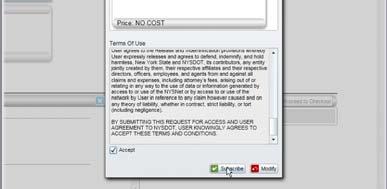
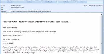
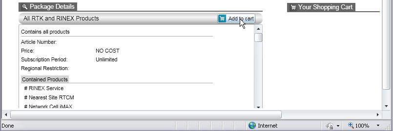
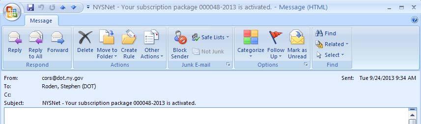
1 GPS/GLONASS (GG) January 2015 NYSAPLS Conference NYSNet 2015 GLONASS Upgrades Antenna Types Single Base/Network RTK GPS/GLONASS (GG) Single Base GPS/GLONASS (GG) Network RTK RT Products (NTRIP Mount Points) Tie to National Spatial Reference Network Positioning/Monitoring/Updating Heights Registering/Subscribing to products Station/Network Status January 2015 NYSAPLS Conference
Status")
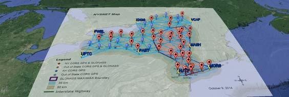


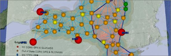
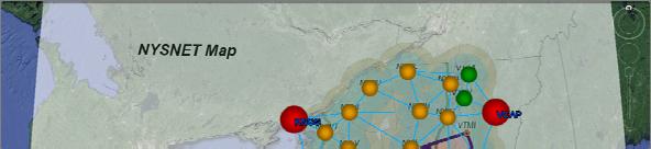
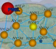
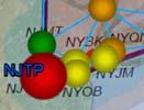
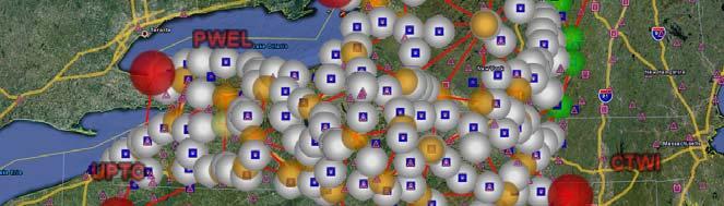
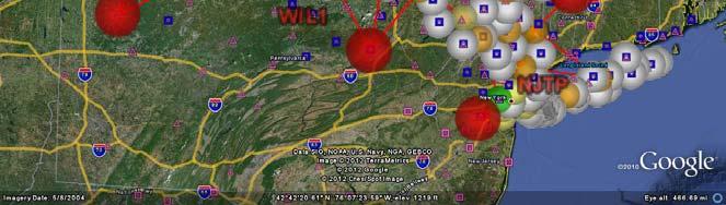
2 GPS/GLONASS (GG)Status (Single Sites/Nearest) January 2015 NYSAPLS Conference GPS/GLONASS (GG)Status (Network RTK) January 2015 NYSAPLS Conference


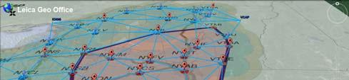
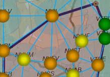
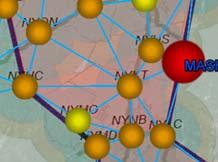
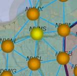
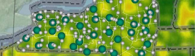
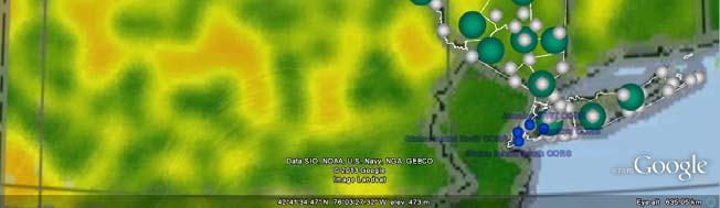
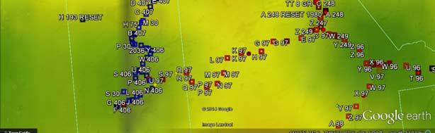
3 Network RTK Clusters January 2015 NYSAPLS Conference January 2015 NYSAPLS Conference


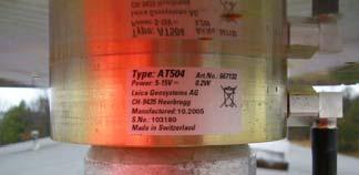
4 Antenna Types January 2015 NYSAPLS Conference Antenna Types January 2015 NYSAPLS Conference


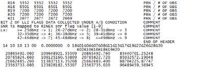
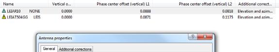
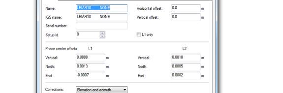

5 Antenna Types / RINEX January 2015 NYSAPLS Conference Antenna Types / RINEX January 2015 NYSAPLS Conference


6 January 15, 2009 NYSAPLS 2010 Conference 11 Antenna Types / RT January 2015 NYSAPLS Conference
7 Why do we need reference stations? Errors in GPS Clock Errors Ephemeras Multipath Atmosphere Without Reference Stations Accuracy From 6-11 Meters With Reference Stations Accuracy From.005 to 1Meter Atmosphere Reference Station On known point Rover Magnitude of errors can be determined at known station and applied at rover position Differential GPS (DGPS) January 2015 NYSAPLS Conference Single Base RTK - Network RTK(NRTK) Atmosphere 10k >10k 1cm +1ppm Reference Station Rover Rover January 2015 NYSAPLS Conference


 Observables")
 of stations.")
8 RTN Single Baseline RTK Nearest Site or Single Site Observables from a single station. Single Baseline Solution. Accuracy dependent upon receiver spec such as: H: 10mm +1ppm V: 20mm +1ppm ppm error partly due to atmospheric differences between reference and rover locations. The further away from the reference station the more atmospheric differences there may be between the reference station and the rover. January 2015 NYSAPLS Conference RTN - Network RTK (NRTK) Network Cell Interpolated RTK Corrections using the Master/Auxiliary Concept (MAC) Observables from master station, and correction differences from auxillary stations. Models correction differences among a cell (group) of stations.. Modeled corrections can reduce ppm error. FOR MORE INFO... January 2015 NYSAPLS Conference
 8/8 + Master Station MAX Rover does the interpolation.")


9 Auxiliary Stations Network RTK (NRTK) RTCM MAC (Master Auxiliary Concept) 8/8 + Master Station MAX Rover does the interpolation. imax-central server does the interpolation and sends corrected data to the rover. Reference Coordinates and Correction Differences Reference Coordinate and Raw GPS Observations January, 2014 NYSAPLS Conference 17 Network RTK Clusters January 2015 NYSAPLS Conference
10 RTN-Connection Terms Connections to the network via internet Cell Modems, RTK Bridge Transceivers User Authentication via standard protocol. NTRIP (Networked Transport of RTCM via Internet Protocol): A secure (login, password required) means of transmitting correction data via TCP/IP. Temporarily, to accommodate non-ntrip rovers, NYSDOT will provide access to RTCM by use of a NMEA user ID (GPUID) and password. NTRIP users will have access to all real time data products. GPUID users will have access to one real time data product. Rover must send in position using navigation standard format. NMEA Non Proprietary Connection Terms January 2015 NYSAPLS Conference RTN- Data Products Standard RTCM formats GIS (sub meter) and Survey (cm) level positioning products. Nearest Site (single reference station) PPM error due to Ionosphere and Atmospheric Delays Network RTK (NRTK) (multiple reference stations) PPM error reduced, RTK accuracy at greater distances from reference station. Standard Data Formats, Non Proprietary January 2015 NYSAPLS Conference


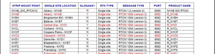


11 NTRIP Mount Points January 2015 NYSAPLS Conference January 2015 NYSAPLS Conference


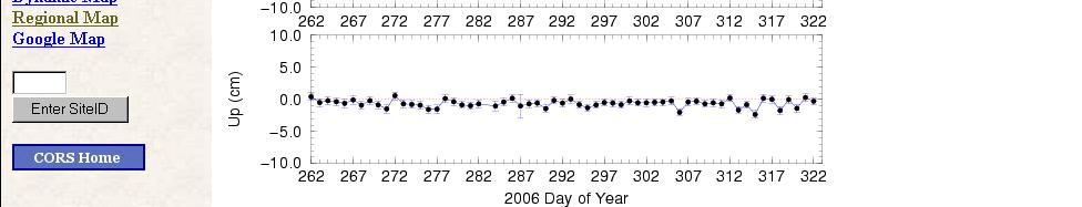
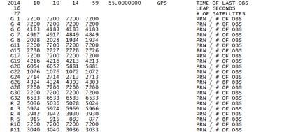
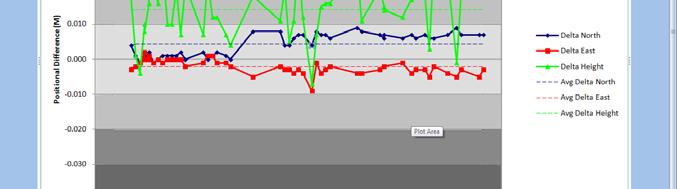
12 January 2015 NYSAPLS Conference National CORS Time Series Plot January 2015 NYSAPLS Conference

13 January 2015 NYSAPLS Conference January 2015 NYSAPLS Conference


14 January 2015 NYSAPLS Conference January 2015 NYSAPLS Conference

15 January 2015 NYSAPLS Conference January 2015 NYSAPLS Conference
16 January 2015 NYSAPLS Conference January 2015 NYSAPLS Conference


17 January 2015 NYSAPLS Conference January 2015 NYSAPLS Conference

18 January 2015 NYSAPLS Conference January 2015 NYSAPLS Conference

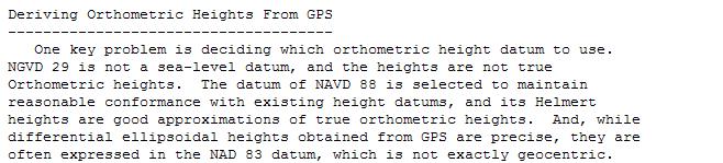
 Ortho Ht = 513.123 +29.")


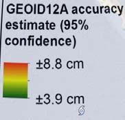
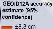
19 January 2015 NYSAPLS Conference NAVD88 From CORS Using GEOID12a H=h-N Ortho Ht = Ellipsoid Ht GEOID Ht Ortho Ht = (-29.25) Ortho Ht = Ortho Ht = [GPS/GEOID 12a] Leveled Ht = Difference = 2.8 cm s GPS Vector HI GEOID12a Leveled Ellipsoid GEOID January 2015 NYSAPLS Conference


20 January 2015 NYSAPLS Conference January 2015 NYSAPLS Conference


21 January, 2014 NYSAPLS Conference 41 January, 2014 NYSAPLS Conference 42 21


22 January, 2014 NYSAPLS Conference 43 January, 2014 NYSAPLS Conference 44 22


23 January, 2014 NYSAPLS Conference 45 January, 2014 NYSAPLS Conference 46 23


24 January, 2014 NYSAPLS Conference 47 January, 2014 NYSAPLS Conference 48 24


25 January 2015 NYSAPLS Conference January 2015 NYSAPLS Conference
26 Summary Questions, Comments, Suggestions? Steve Roden NYSDOT Design Services Bureau, Land Surveying Section January 2015 NYSAPLS Conference
Utilizing A GNSS Network Solution for Utility Applications
 Utilizing A GNSS Network Solution for Utility Applications David Newcomer, PE, PLS GPServ, Inc. newcomer@ (407) 601-5816 AGENDA Types and accuracies of data collection o Autonomous o Meter + o Sub-meter
DYNAMIC RT TECHNOLOGY
 DYNAMIC RT TECHNOLOGY GLOBAL NAVIGATION SATELLITE SYSTEMS (GNSS) POTENTIAL FUTURE DEVELOPMENTS(2005 2017?) GPS MODERNIZATION BLOCK IIF & III GLONASS ENHANCEMENTS (K & M) EUROPEAN UNION - GALILEO CHINA
GNSS Low-Cost High-Accuracy Receiver (L-CHAR)
") GNSS Low-Cost High-Accuracy Receiver (L-CHAR) Dinesh Manandhar Center for Spatial Information Science The University of Tokyo Contact Information: dinesh@iis.u-tokyo.ac.jp Slide : 1 High Accuracy Receivers
GNSS Low-Cost High-Accuracy Receiver (L-CHAR) Dinesh Manandhar Center for Spatial Information Science The University of Tokyo Contact Information: dinesh@iis.u-tokyo.ac.jp Slide : 1 High Accuracy Receivers
Introduction to GNSS Base-Station
 Introduction to GNSS Base-Station Dinesh Manandhar Center for Spatial Information Science The University of Tokyo Contact Information: dinesh@iis.u-tokyo.ac.jp Slide : 1 Introduction GPS or GNSS observation
Using RTK GNSS Wisely
 Using RTK GNSS Wisely February 017 Autonomous Positioning Differential Positioning Concept: Detect and cancel identical errors with simultaneous observation. F + E = G + E 1 Static & RTK Computations Static
Trimble GPSNet 2.5 Software for GNSS Infrastructure: New Features. Martin Janousek - Trimble Technical Support - Infrastructure
 Trimble GPSNet 2.5 Software for GNSS Infrastructure: New Features Martin Janousek - Trimble Technical Support - Infrastructure GPSNet Users Seminar Munich, March 30 th /31 th 2006 Overview Support for
The Reasons to Succeed or to Fail a GNSS Network RTK Project
 The Reasons to Succeed or to Fail a GNSS Network RTK Project Joël van Cranenbroeck, Managing Director CGEOS Creative Geosensing sprl-s, Belgium Andy Yin, International Sales Director ComNav Technology
Accuracy Evaluation Internet-Based GNSS for Kinematic Surveying the Case Study in Thailand
 Accuracy Evaluation Internet-Based GNSS for Kinematic Surveying the Case Study in Thailand Kritsada Anantakarn 1 1 Faculty of Engineering and Architectural : Uthenthawai campus. Rajamongala University
The Global Positioning Sytem II 10/19/2017
 The Global Positioning System II Field Experiments 10/19/2017 5-1 Mexico DGPS Field Campaign Cenotes in Tamaulipas, MX, near Aldama 10/19/2017 5-2 Are Cenote Water Levels Related? 10/19/2017 5-3 M. Helper,
The Global Positioning System II Field Experiments. 10/10/2013 GEO327G/386G, UT Austin 5-1
 The Global Positioning System II Field Experiments 10/10/2013 GEO327G/386G, UT Austin 5-1 Mexico DGPS Field Campaign Cenotes in Tamaulipas, MX, near Aldama 10/10/2013 GEO327G/386G, UT Austin 5-2 Are Cenote
MGA Webinar Series : 1 Very Cheap RTK Receivers: Changing the Landscape of Positioning Services
 MGA Webinar Series : 1 Very Cheap RTK Receivers: Changing the Landscape of Positioning Services Dinesh Manandhar Center for Spatial Information Science The University of Tokyo Contact Information: dinesh@iis.u-tokyo.ac.jp
The Global Positioning System II Field Experiments
 The Global Positioning System II Field Experiments 5-1 Mexico DGPS Field Campaign Cenotes in Tamaulipas, MX, near Aldama 5-2 Are Cenote Water Levels Related? 5-3 DGPS Static Survey of Cenote Water Levels
SKPOS. Slovak real-time positioning service - a multifunctional tool for precise object and phenomena positioning
 SKPOS Slovak real-time positioning service - a multifunctional tool for precise object and phenomena positioning WHAT IS SKPOS AND HOW DOES IT WORK? Slovak real-time positioning service is a multifunctional
Leica GRX1200 Series High Performance GNSS Reference Receivers
 Leica GRX1200 Series High Performance GNSS Reference Receivers Leica GRX1200 Series For permanent reference stations The Leica GRX1200 Series, part of Leica s new System 1200, is designed specifically
Differential GPS Positioning over Internet
 Abstract Differential GPS Positioning over Internet Y. GAO AND Z. LIU Department of Geomatics Engineering The University of Calgary 2500 University Drive N.W. Calgary, Alberta, Canada T2N 1N4 Email: gao@geomatics.ucalgary.ca
NTRIP Background History, Development & BKG. Networked Transport of RTCM via Internet Protocol
 Networked Transport of RTCM via Internet Protocol Networked Transport of RTCM via Internet Protocol Bundesamt für Kartographie und Geodäsie Motivation: Use Internet to transport GNSS corrections Communication
FieldGenius Technical Notes GPS Terminology
 FieldGenius Technical Notes GPS Terminology Almanac A set of Keplerian orbital parameters which allow the satellite positions to be predicted into the future. Ambiguity An integer value of the number of
ISG & ISPRS 2011, Sept , 2011 Shah Alam, MALAYSIA
 ISG & ISPRS 2011, Sept. 27-29, 2011 Shah Alam, MALAYSIA THE PERFORMANCE OF ISKANDARnet DGPS SERVICE Wan Aris. W. A. 1, Musa., T. A. 1, Othman. R 1 GNSS & Geodynamic Research Group, Faculty of Geoinformation
NRTK services in Ireland - an Evaluation
 NRTK services in Ireland - an Evaluation Dr. Audrey Martin & Dr. Eugene McGovern, Dublin Institute of Technology, Ireland. FIG Working Week, May 12 Ireland s Survey Infrastructure 1995 IRENET ING 185 Ground
al T TD ) ime D Faamily Products The RTD Family of products offers a full suite of highprecision GPS sensor positioning and navigation solutions for:
 ime D Faamily Products The RTD Family of products offers a full suite of highprecision GPS sensor positioning and navigation solutions for:") Reeal ynnamics al T amics (R TD ) ime D RTD) Time Dy Faamily mily ooff P roducts Products The RTD Family of products offers a full suite of highprecision GPS sensor positioning and navigation solutions
Reeal ynnamics al T amics (R TD ) ime D RTD) Time Dy Faamily mily ooff P roducts Products The RTD Family of products offers a full suite of highprecision GPS sensor positioning and navigation solutions
European Position Determination System. Technical Standards
 European Position Determination System Technical Standards Revised 2 nd Edition 24 April 2008 Resolution of the International EUPOS Steering Committee 13 th Conference, Bucharest, Romania, 23 24 April
SUPPORT OF NETWORK FORMATS BY TRIMBLE GPSNET NETWORK RTK SOLUTION
 SUPPORT OF NETWORK FORMATS BY TRIMBLE GPSNET NETWORK RTK SOLUTION TRIMBLE TERRASAT GMBH, HARINGSTRASSE 19, 85635 HOEHENKIRCHEN, GERMANY STATUS The Trimble GPSNet network RTK solution was first introduced
SurvCE: configuration of S9III/S8 for a UHF radio connection
 SurvCE: configuration of S9III/S8 for a UHF radio connection This tutorial will show the basic settings of a S9III/S8 as a base, transmitting with its internal radio or with a generic external radio, and
Leica GRX1200+ Series High Performance GNSS Reference Receivers
 Leica GRX1200+ Series High Performance GNSS Reference Receivers Leica GRX1200+ Series For permanent reference stations The Leica GRX1200+ Series, part of Leica's future proof System 1200, is designed specifically
SERVIR: The Portuguese Army CORS Network for RTK
 SERVIR: The Portuguese Army CORS Network for RTK António Jaime Gago AFONSO, Rui Francisco da Silva TEODORO and Virgílio Brito MENDES, Portugal Key words: GNSS, RTK, VRS, Network ABSTRACT Traditionally
9/26/2016. Accuracy with GNSS What are you getting? Presented By Tom Bryant PLS Kelly Harris PLS Seiler Instrument
 Accuracy with GNSS What are you getting? Presented By Tom Bryant PLS Kelly Harris PLS Seiler Instrument 1 What We Will Talk About Today What coordinate system should I use in my data collector Site Calibrations-what
When do you expect Athena to be available for VS330? This is currently being beta-tested and will be released in the very near future.
 Why Athena? Athena GNSS Engine What improvements does Athena offer over the RTK firmware I m running now? Compared to the Hemisphere firmware most users are currently using (Qf4), there are significant
The Kingdom Of Saudi Arabia GNSS Real Time Kinematic Network (MRTN) And Beyond (A Case Study for High Accuracy VRS Correction Test)
 And Beyond (A Case Study for High Accuracy VRS Correction Test)") The Kingdom Of Saudi Arabia GNSS Real Time Kinematic Network (MRTN) And Beyond (A Case Study for High Accuracy VRS Correction Test) Ali ALOMAR, Saudi Arabia, Dr. Ramazan YANAR Turkey, Sami ALBALAWI, Saeed
The Kingdom Of Saudi Arabia GNSS Real Time Kinematic Network (MRTN) And Beyond (A Case Study for High Accuracy VRS Correction Test) Ali ALOMAR, Saudi Arabia, Dr. Ramazan YANAR Turkey, Sami ALBALAWI, Saeed
Dynamic Global Navigation Satellite System antenna position verification using raw pseudorange information
 Scientific Journals of the Maritime University of Szczecin Zeszyty Naukowe Akademii Morskiej w Szczecinie 016, 46 (118), 76 81 ISSN 1733-8670 (Printed) Received: 31.08.015 ISSN 39-0378 (Online) Accepted:.03.016
USER MANUAL FIELDBEE AND RTK BEE STATION FULL VERSION. WE PROVIDE ONLINE SUPPORT: VERSION 1.0.
 USER MANUAL FULL VERSION VERSION 1.0. FIELDBEE AND RTK BEE STATION WE PROVIDE ONLINE SUPPORT: support@efarmer.mobi info@efarmer.mobi CONTENTS TABLE OF CONTENTS INTRODUCTION... 3 3 WAYS OF USING FIELDBEE...
RTK Rover Performance using the Master- Auxiliary Concept
 RTK Rover Performance using the Master- Auxiliary Concept N. Brown, I. Geisler and L. Troyer Networked Reference Stations and Structural Monitoring Leica Geosystems, Heinrich-Wild-Strasse, Heerbrugg, 9435,
Positioning Techniques. João F. Galera Monico - UNESP Tuesday 12 Sep
 Positioning Techniques João F. Galera Monico - UNESP Tuesday 12 Sep Positioning methods Absolute Positioning Static and kinematic SPP and PPP Relative Positioning Static Static rapid Semi kinematic Kinematic
GIS Mapping with SiReNT Real-time Differential GPS
 GIS Mapping with SiReNT Real-time Differential GPS Victor KHOO Hock Soon ABSTRACT Singapore Land Authority No.8, Shenton Way #26-01 Singapore 068811 Email: Victor_khoo@sla.gov.sg Accurate and up-to-date
gogps a navigation software to enhance the accuracy of low-cost GPS receivers Eugenio Realini Mirko Reguzzoni Osaka City University, Japan
 gogps a navigation software to enhance the accuracy of low-cost GPS receivers Eugenio Realini Osaka City University, Japan Oct. 21st FOSS4G2009 Mirko Reguzzoni OGS c/o Politecnico di Milano, Italy Why
Next Generation Positioning Infrastructure
 Next Generation Positioning Infrastructure The GNSS Network in the 21 st Century Joel VAN CRANENBROECK & Partners Beyond East & West GeoSensing Community 1 INFRASTRUCTURE "The installations that form the
Alberding solutions for GNSS infrastructure operators
 Tamás Horváth Alberding solutions for GNSS infrastructure operators 21.11.2017 1/35 Alberding solutions for GNSS infrastructure operators Tamás Horváth Alberding GmbH 4 th EUPOS Technical Meeting 21-22
RTK Rover Performance using the Master-Auxiliary Concept
 Journal of Global Positioning Systems (2006) Vol. 5, No. 1-2:135-144 RTK Rover Performance using the Master-Auxiliary Concept N. Brown, I. Geisler and L. Troyer Networked Reference Stations and Structural
GAVIN DOCHERTY & CRAIG ROBERTS School of Surveying & Spatial Information Systems. University of NSW
 FIG2010, Sydney, Australia 15 April 2010 The impact of Solar Cycle 24 on Network RTK in Australia GAVIN DOCHERTY & CRAIG ROBERTS School of Surveying & Spatial Information Systems University of NSW School
FIELD TEST OF THE GPS+GLONASS RTK AT THE CAGLIARI PERMANENT STATION VIA INTERNET. Giannina Sanna, Giuseppina Vacca
 FIELD TEST OF THE GPS+GLONASS RTK AT THE CAGLIARI PERMANENT STATION VIA INTERNET Giannina Sanna, Giuseppina Vacca University of Cagliari Department of Structural Engineering P.zza D Armi 913 Cagliari,
GNSS POST-PROCESSING SOFTWARE
 GNSS POST-PROCESSING SOFTWARE Product Overview // July 2018 EZSURV POST-PROCESSING SOFTWARE EZSurv software is designed to edit, process and analyze raw GNSS (Global Navigation Satellite System) data to
Sales & Technical Support: &
 Sales & Technical Support: sales@tersus-gnss.com & support@tersus-gnss.com Table of Content Table of Content...1 List of Figures...3 List of Tables... 4 Revision History... 5 1. Introduction...6 1.1 Overview...6
Trimble GNSS Infrastructure
 Trimble GNSS Infrastructure A History of Innovation Trimble, the first company to offer commercial GPS products company to integrate GPS with communications technology RTK system in the market in 1994
IMO WORLDWIDE RADIONAVIGATION SYSTEM (WWRNS) Study on Communication Techniques for High Accuracy DGPS in the Republic of Korea
 Study on Communication Techniques for High Accuracy DGPS in the Republic of Korea") INTERNATIONAL MARITIME ORGANIZATION E IMO SUB-COMMITTEE ON SAFETY OF NAVIGATION 52nd session Agenda item 12 NAV 52/INF.8 12 May 2006 ENGLISH ONLY WORLDWIDE RADIONAVIGATION SYSTEM (WWRNS) Study on Communication
INTERNATIONAL MARITIME ORGANIZATION E IMO SUB-COMMITTEE ON SAFETY OF NAVIGATION 52nd session Agenda item 12 NAV 52/INF.8 12 May 2006 ENGLISH ONLY WORLDWIDE RADIONAVIGATION SYSTEM (WWRNS) Study on Communication
TrigNet: The South African Network of Continuously Operating GNSS Base Stations
 TrigNet: The South African Network of Continuously Operating GNSS Base Stations R Wonnacott ESESA User Need Workshop Thread 2: Status of Current GNSS Applications in South Africa Somerset West 2 March
Receiver Technology CRESCENT OEM WHITE PAPER AMY DEWIS JENNIFER COLPITTS
 CRESCENT OEM WHITE PAPER AMY DEWIS JENNIFER COLPITTS With offices in Kansas City, Hiawatha, Calgary and Scottsdale, Hemisphere GPS is a global leader in designing and manufacturing innovative, costeffective,
Leica GRX1200 Series Technical Data
 Leica GRX1200 Series Technical Data GRX1200 Series Technical Data Summary Description GRX1200 Lite GRX1200 Classic GRX1200 GG Pro Continuously Operating Reference Station (CORS) GPS GNSS Survey, geodetic,
Performance Assessment of a GPS Network RTK Service
 Jose APONTE, Xiaolin MENG and Mark BURBIDGE, United Kingdom Key words: network RTK GPS, corrections, service, GPRS, performance. SUMMARY Network RTK (NRTK) GPS positioning is considered the most appropriate
2/15/2018. Survey grade GPS. (or enough information to be very dangerous) Raymond Hintz University of Maine
 Raymond Hintz University of Maine") Survey grade GPS (or enough information to be very dangerous) Raymond Hintz University of Maine Ray.hintz@maine.edu GPS is old school The correct term is now GNSS (Global Navigation Satellite System) which
Survey grade GPS (or enough information to be very dangerous) Raymond Hintz University of Maine Ray.hintz@maine.edu GPS is old school The correct term is now GNSS (Global Navigation Satellite System) which
The GNSS Active Control Point Concept Get the {dynamic} Reference Points when You Need
 The GNSS Active Control Point Concept Get the {dynamic} Reference Points when You Need Joel van Cranenbroeck Chair of Commission 6 WG 6.2 International Federation of Surveyors (FIG) Belgium, Europa 2 3
Leica MNS1200 GNSS Series Toughest GNSS solution for toughest sites
 Leica MNS1200 GNSS Series Toughest GNSS solution for toughest sites >Fast >Smart >Integrated Leica MNS1200 GNSS Series Robust GNSS machine navigation solution The Leica MNS1200 GNSS (Global Navigation
SLX-1 Multi-Application GNSS Receiver
 SLX-1 Multi-Application GNSS Receiver w w w.sa tla b g p s. c o m SLX-1 Multi-Application GNSS Receiver Designed for CORS Ready for Anything European Standards GPS GLONASS BEIDOU GALILEO SBAS QZSS Long
ASG-EUPOS reference system
 Head Office of Geodesy and Cartography Department of Geodesy, Cartography and GIS ASG-EUPOS reference system Last year activities and future plans Szymon Wajda Prime specialist Bratislava, 21-22.11.2017
Quick Start. Tersus GNSS Center. Configuration Tools for Tersus GNSS RTK Systems.
 Quick Start Tersus GNSS Center Configuration Tools for Tersus GNSS RTK Systems www.tersus-gnss.com July, 2016 1. Quick Start Guide of Tersus GNSS Center This quick start guide provides the basic information
Trimble NetR9 Reference Receiver Series: Frequently Asked Questions
 July 2010 Trimble NetR9 Reference Receiver Series: Frequently Asked Questions What is the Trimble NetR9 GNSS reference receiver? The Trimble NetR9 GNSS (Global Navigation Satellite System) reference receiver
Article Number: 457 Rating: Unrated Last Updated: Wed, Sep 2, 2009 at 3:46 PM
 T opcon GB-1000 - Receiver Board Firmware Version 3.4 Article Number: 457 Rating: Unrated Last Updated: Wed, Sep 2, 2009 at 3:46 PM Topcon has recently released GNSS receiver board firmware version 3.4
One Source for Positioning Success
 novatel.com One Source for Positioning Success RTK, PPP, SBAS OR DGNSS. NOVATEL CORRECT OPTIMIZES ALL CORRECTION SOURCES, PUTTING MORE POWER, FLEXIBILITY AND CONTROL IN YOUR HANDS. NovAtel CORRECT is the
HEAD OFFICE OF GEODESY AND CARTOGRAPHY. Wspolna 2 Str., Warsaw, Poland ASG-EUPOS THE POLISH CONTRIBUTION TO THE EUPOS PROJECT
 HEAD OFFICE OF GEODESY AND CARTOGRAPHY Wspolna 2 Str., 00-926 Warsaw, Poland ASG-EUPOS THE POLISH CONTRIBUTION TO THE EUPOS PROJECT Project Part-Financed by European Union European Regional Development
Development of Hong Kong GNSS infrastructure
 Development of Hong Kong GNSS infrastructure Wu Chen Department of Land Surveying and Geoinformatics (LSGI) Hong Kong Polytechnic University Hong Kong 1 Research Areas Research Areas GNSS Positioning and
Leica Spider Infrastructure HW Solutions Introducing: Leica GR30 & GR50
 Leica Spider Infrastructure HW Solutions Introducing: Leica GR30 & GR50 Reliable solutions for today and tomorrow Leica Spider Integrated Solutions Introducing: Leica GR30 & GR50 Outline Introducing Leica
GNSS & Coordinate Systems
 GNSS & Coordinate Systems Matthew McAdam, Marcelo Santos University of New Brunswick, Department of Geodesy and Geomatics Engineering, Fredericton, NB May 29, 2012 Santos, 2004 msantos@unb.ca 1 GNSS GNSS
Real time GPS Networks (RTN) and their Implications with Geographic Information Systems (GIS)
 and their Implications with Geographic Information Systems (GIS)") Brent A. JONES, USA and Kevin M. KELLY, USA Key words: RTK (Real Time Kinematic), RTN (Real Time Networks), GPS (Global Positioning System), GIS (Geographic Information System), cadastral survey, data
Brent A. JONES, USA and Kevin M. KELLY, USA Key words: RTK (Real Time Kinematic), RTN (Real Time Networks), GPS (Global Positioning System), GIS (Geographic Information System), cadastral survey, data
ProMark 3 RTK. White Paper
 ProMark 3 RTK White Paper Table of Contents 1. Introduction... 1 2. ProMark3 RTK Operational Environment... 2 3. BLADE TM : A Unique Magellan Technology for Quicker Convergence... 3 4. ProMark3 RTK Fixed
Global Correction Services for GNSS
 Global Correction Services for GNSS Hemisphere GNSS Whitepaper September 5, 2015 Overview Since the early days of GPS, new industries emerged while existing industries evolved to use position data in real-time.
ProMark 500 White Paper
 ProMark 500 White Paper How Magellan Optimally Uses GLONASS in the ProMark 500 GNSS Receiver How Magellan Optimally Uses GLONASS in the ProMark 500 GNSS Receiver 1. Background GLONASS brings to the GNSS
C94-M8P Application Board Setup Guide
 C94-M8P Application Board Setup Guide locate, communicate, accelerate UBX-16009722 R02 C94-M8P Board Connections and Interfaces J1 J10 J2 J3 J1: RS232 UART M8P/Radio J2: USB M8P J3: External battery /
Positioning Australia for its farming future
 Positioning Australia for its farming future Utilizing the Japanese satellite navigation QZSS system to provide centimetre positioning accuracy across ALL Australia David Lamb 1,2 and Phil Collier 2 1
GrafNav/GrafNet. The following document is a detailed description of Waypoint Consulting Inc.'s GrafNav/GrafNet post-processing software package.
 GrafNav/GrafNet The following document is a detailed description of Waypoint Consulting Inc.'s GrafNav/GrafNet post-processing software package. What is GrafNav/GrafNet? What is included with GrafNav/GrafNet?
Real-Time Data Flow and Product Generation for GNSS. Jet Propulsion Laboratory. California Institute of Technology. Natural Resources Canada
 Real-Time Data Flow and Product Generation for GNSS Ronald J. Muellerschoen rjm @ mailhost4.jpl.nasa.gov Abstract Jet Propulsion Laboratory California Institute of Technology Mark Caissy caissy @NRCan.gc.ca
High Precision GNSS for Mapping & GIS Professionals
 High Precision GNSS for Mapping & GIS Professionals Agenda Address your needs for GNSS knowledge. GNSS Basics Satellite Ranging Fundamentals (Code $ Carrier) Differential Corrections (Post Processed $
Survey grade GPS. (or enough information to be very dangerous) Raymond Hintz University of Maine
 Raymond Hintz University of Maine") Survey grade GPS (or enough information to be very dangerous) Raymond Hintz University of Maine Ray.hintz@maine.edu GPS is old school The correct term is now GNSS (Global Navigation Satellite System) which
Survey grade GPS (or enough information to be very dangerous) Raymond Hintz University of Maine Ray.hintz@maine.edu GPS is old school The correct term is now GNSS (Global Navigation Satellite System) which
SL 300 GNSS Receiver. w w w.sa tla b g p s. c o m
 SL 300 GNSS Receiver w w w.sa tla b g p s. c o m SL 300 GNSS Receiver The Ultimate Expandable Handheld Smart GNSS Sensor with Multi Constellation Tracking European Standards Lightweight Bluetooth Multi
ENGI 3703 Surveying and Geomatics
 Satellite Geometry: Satellites well spread out in the sky have a much stronger solution to the resection type problem (aka trilateration) then satellite that are grouped together. Since the position of
GNSS POST-PROCESSING SOFTWARE
 GNSS POST-PROCESSING SOFTWARE Product Overview // June 2014 EZSURV POST-PROCESSING SOFTWARE EZSurv software is designed to edit, process and analyze raw GNSS (Global Navigation Satellite System) data to
Introduction to Geographic Information Science. Last Lecture. Today s Outline. Geography 4103 / GNSS/GPS Technology
 Geography 4103 / 5103 Introduction to Geographic Information Science GNSS/GPS Technology Last Lecture Geoids Ellipsoid Datum Projection Basics Today s Outline GNSS technology How satellite based navigation
Monitoring Lecture ETH Zürich, Michael Rutschmann
 Monitoring Lecture 5.11.2008 ETH Zürich, Michael Rutschmann Monitoring lecture Contents 1. Monitoring System Intro 2. Different Setup of Monitoring Systems 3. GeoMoS (Monitor and Analyzer) 4. Setup of
Towards a EUREF Service Providing Real-time GNSS Clock and Orbit Corrections
 Towards a EUREF Service Providing Real-time GNSS Clock and Orbit Corrections G. Weber 1), W. Söhne 1), A. Stürze 1), L. Mervart 2) 1) Federal Agency for Cartography and Geodesy, Frankfurt am Main, Germany
Skytraq Manual (Single frequency receiver) Procedure to logging skytraq data with RTKNAVI
 Procedure to logging skytraq data with RTKNAVI") Tokyo University of Marine Science and Technology Skytraq Manual (Single frequency receiver) Procedure to logging skytraq data with RTKNAVI TUMSAT 1 Skytraq Receiver http://www.skytraq.com.tw/products/products.html
Tokyo University of Marine Science and Technology Skytraq Manual (Single frequency receiver) Procedure to logging skytraq data with RTKNAVI TUMSAT 1 Skytraq Receiver http://www.skytraq.com.tw/products/products.html
Cost-effective precise positioning for geospatial applications
 Cost-effective precise positioning for geospatial applications Octavian Andrei Department of Survey Engineering, Chulalongkorn University, Thailand IPNTJ Summaer School 2014 Jul 28 Aug 02, Total Value
Cross-Border EUPOS Data Exchange First Experience
 Cross-Border EUPOS Data Exchange First Experience Eimuntas Paršeliūnas, Marius Petniūnas, Domantas Bručas (Institute of Geodesy of Vilnius Gediminas Technical University, Lithuania) Wieslaw Graszka (Head
The RTN Guideline Work Group Leaders: William Henning, team leader, editor. Dan Martin, Site Considerations group leader
 March 2011 v. 2.0 1 The RTN Guideline Work Group Leaders: William Henning, team leader, editor Dan Martin, Site Considerations group leader Gavin Schrock, Planning and Design group leader Gary Thompson,
GNSS 101 Bringing It Down To Earth
 GNSS 101 Bringing It Down To Earth Steve Richter Frontier Precision, Inc. UTM County Coordinates NGVD 29 State Plane Datums Scale Factors Projections Session Agenda GNSS History & Basic Theory Coordinate
Geodetic Reference via Precise Point Positioning - RTK
 2012 Geo++ GmbH Geodetic Reference via Precise Point Positioning - RTK Gerhard Wübbena Geo++ GmbH 30827 Garbsen Germany www.geopp.de 2012 Geo++ GmbH Contents Terms and Abbreviations GNSS Principles GNSS
RTN 101: RTN101. >> By Gavin Schrock, LS. Technological Approaches to Network-based Corrections (Part 7)
") RTN101 Approaches, Implementations, Brands & Choices Network corrected real-time is a technological approach to high precision GPS/ GNSS positioning that has been theorized about, studied, experimented
RTN101 Approaches, Implementations, Brands & Choices Network corrected real-time is a technological approach to high precision GPS/ GNSS positioning that has been theorized about, studied, experimented
GeoMax GNSS Zenith10 & Zenith20 Series
 GeoMax GNSS Zenith10 & Zenith20 Series GeoMax About Us At GeoMax we provide a com- group with strong market At GeoMax, we concentrate on prehensive portfolio of inte- positions within measurement providing
POS MV Position and Attitude sensors. Applications. > > High reliability in all dynamic conditions. > > Immunity to GNSS outages
 45 27 39.384 N 9 07 30.145 E POS MV Position and Attitude sensors Applanix technology and support gives you the advantage: lower costs of deployment, faster times to completion, and improved quality of
An Evaluation of the Performance of Network RTK GNSS Services in Ireland
 Dublin Institute of Technology ARROW@DIT Conference Papers Spatial Information Sciences Research Group 212 An Evaluation of the Performance of Network RTK GNSS Services in Ireland Audrey Martin Dublin
SL 300 GNSS Receiver. w w w. s a t l a b g p s. c o m
 SL 300 GNSS Receiver w w w. s a t l a b g p s. c o m SL 300 6G GNSS Receiver The Ultimate Expandable Handheld Smart GNSS Sensor with 6G Tracking European Standards Lightweight Bluetooth GPS GLONASS BEIDOU
Asian Journal of Science and Technology Vol. 08, Issue, 11, pp , November, 2017 RESEARCH ARTICLE
 Available Online at http://www.journalajst.com ASIAN JOURNAL OF SCIENCE AND TECHNOLOGY ISSN: 0976-3376 Asian Journal of Science and Technology Vol. 08, Issue, 11, pp.6697-6703, November, 2017 ARTICLE INFO
RELEASE NOTES. Trimble. SPS Series Receivers. Introduction. New features and changes
 RELEASE NOTES Trimble SPS Series Receivers Introduction New features and changes Version 4.42 Revision A June 2011 F Corporate office Trimble Navigation Limited Engineering and Construction group 5475
RTCM State Space Representation (SSR) Overall Concepts Towards PPP-RTK
 Overall Concepts Towards PPP-RTK") RTCM State Space Representation (SSR) Overall Concepts Towards PPP-RTK Gerhard Wübbena Geo++ GmbH 30827 Garbsen Germany www.geopp.de Contents Terms and Abbreviations RTCM-SSR Working Group GNSS Error Sources
RTCM State Space Representation (SSR) Overall Concepts Towards PPP-RTK Gerhard Wübbena Geo++ GmbH 30827 Garbsen Germany www.geopp.de Contents Terms and Abbreviations RTCM-SSR Working Group GNSS Error Sources
AN ABSTRACT OF THE THESIS OF. Mahsa Allahyari for the degree of Master of Science in Civil Engineering presented on December 9, 2016.
 AN ABSTRACT OF THE THESIS OF Mahsa Allahyari for the degree of Master of Science in Civil Engineering presented on December 9, 2016. Title: Accuracy Evaluation of Real-Time GNSS Survey Observations Abstract
FieldGenius Technical Notes GPS Differential Corrections
 FieldGenius Technical tes GPS Differential Corrections Introduction The accuracy requirement of survey grade or mapping grade GPS applications for real time positioning requires the use of differential
Mark s MobileMapper 120, ProMark 120, ProMark 220 Notes
 1 Mark s MobileMapper 120, ProMark 120, ProMark 220 Notes By: Mark Silver, ms@igage.com, +1 801-412-0011 Updated: 19 November 2012 All of the MobileMapper and ProMark products, software and accessories
RELEASE NOTES. Introduction. Trimble Infrastructure GNSS Series Receivers
 RELEASE NOTES Trimble Infrastructure GNSS Series Receivers These release notes describe the latest improvements made to the Trimble NetR9 GNSS Infrastructure series receivers. Introduction New Features
Performance of Research-Based N-RTK Positioning System in ISKANDAR Malaysia
 1 International Symposium on GPS/GNSS October -8, 1. Performance of Research-Based N-RTK Positioning System in ISKANDAR Malaysia Shariff, N. S. M., Musa, T. A., Omar, K., Ses, S. and Abdullah, K. A. UTM-GNSS
RTN Measurements Accuracy Test in Reference to MSPP**
 GEOMATICS AND ENVIRONMENTAL ENGINEERING Volume 3 Number 2 2009 Andrzej Uznañski* RTN Measurements Accuracy Test in Reference to MSPP** 1. Introduction In the recent years, the Real Time Kinematic measurements
Compact Data Transmission Standard for High-Precision GPS
 Compact Data Transmission Standard for High-Precision GPS Dr. Nicholas C. Talbot Trimble Navigation BIOGRAPHY Nicholas Talbot graduated from the Royal Melbourne Institute of Technology, Australia, with
Global Positioning Systems - GPS
 Global Positioning Systems - GPS GPS Why? What is it? How does it work? Differential GPS How can it help me? GPS Why?? Where am I? How do I get there? Where are you, and how do I get to You? WHO CARES???
CHC i80 GNSS Receiver QuickTour with LandStar7. (PDA Network Mode)
") CHC i80 GNSS Receiver QuickTour with LandStar7 (PDA Network Mode) 1.Prerequisites Hardware: CHC i80 rover, Controller Kit, SIM card,lithium Battery, pole Software: LandStar7 2.Steps to set i80 working
CHC i80 GNSS Receiver QuickTour with LandStar7 (PDA Network Mode) 1.Prerequisites Hardware: CHC i80 rover, Controller Kit, SIM card,lithium Battery, pole Software: LandStar7 2.Steps to set i80 working