Role of Manufacturers to support Geodetic Infrastructure
|
|
|
- Melinda Thompson
- 6 years ago
- Views:
Transcription


1 FIG / UN-GGIM-AP / JUPEM Geospatial and GNSS CORS Infrastructure Forum Kuala Lumpur, Malaysia Oct 2016 Role of Manufacturers to support Geodetic Infrastructure Neil Ashcroft Leica Geosystems

2 Information Technologies 2

3 Hexagon s Corporate Strategic Direction Broaden capabilities Narrow the GAPs between Real and Digital World 3
4 End User - Manufacturer Relationship What is expected? Deliver / Provide Appropriate products for Measurement tasks Total Mechanical, Automated, Imaging GNSS GIS, GPS, GNSS, Single Frequency, Multi Frequency Laser Scanners Fixed, Mobile UAS Lasers, Levels, Accessories etc Reliable products Local Servicing and scheduled Maintenance, upgradability Usable products Simple User Interfaces Customised User Interfaces Value for money Cost of ownership Strong reliable partner 4

5 AR10: Multi GNS GNSS Hardware Future Proofing AT504: GPS Only (D+M) AT504GG: GPS/GLO (D+M) AR25: Multi GNSS (D+M) CRS1000 : GPS : C1, P2 RS500 : GPS : C1, P2 GRX1200 : GPS : C1, P2 GRX1200GGPro : GPS : C1, C2, P2 GLO : C1, P2 GRX1200+GNSS : GPS : C1, C2, P2,L5 GLO : C1, P2 GR10 : GPS : C1, C2, P2,L5 GLO : C1, P2 GAL : E1, E5a, E5b, E5a+b GAL : E1, E5a, E5b, E BDS : B1, B2 BDS : B1, B2 QZSS QZSS 5
6 What can manufacturers do to further assist with CORS infrastrcture? Respond to Requests For Information in order for you to put together a feasible operating CORS. Will provide detailed advice on what needs to be considered. Monumentation, Communication, Power Business Models Some key points to consider GNSS Antennas should rarely be changed. Get antennas that are able to track all planned Satellite Signals now. Examine the upgrade path of GNSS Receivers to ensure they are upwards compatible with tracking appropriate Satellite Signals WHEN you need them. Get the GNSS receiver to log native RINEX on the sensor and FTP push to central archive store directly. Allows for greater manufacturer interoperability at the Central Server Reliable, Robust Communication system Set up front conditions that when Central Software has additional sites added there is a single fee, not manufacturer independent. 7


7 Communications Software informs user of problems User needs to understand the message and act appropriately 8
8 The Higgins Model Specify Network Process Deliver Specify System Own Network the Data Process Network Deliver Service Target Density, Coverage, Accuracy, Reliability and Availability Site Quality Equipment Quality Geodetic Reference Frame Data Services Produced Site Selection Site Construction Equipment Purchasing Station Data Comms Site Maintenance Equipment Replacement Cycle Data Comms from Network Control Centre Quality Control of Raw Data Data Archive Copy of Network Data Processing Production of Data Streams Data Wholesaling Retailer Support Retail Sale of Data Products Marketing Rover Equipment Support End User Support Liaison with User Comms Providers Data Access Policy Governance Courtesy of M.Higgins, DERM, QLD, Australia 9
9 Non-Government data for Datum Verification or Science A Retailer may service Multiple market segments or may specialise The Higgins Model Specify Network Process Deliver AuScope Geospatial Committee for Science Issues Primarily by Federal, State And Territory Governments Responsible For Geodesy (via ICSM) User needs Input from User Groups Geoscience Australia's ARGN AuScope funded AuScope matched State/Territory Government Non-AuScope Non-Government Geoscience Australia Gathers data from the unified National network State/Territory Government Sub-Networks Single Station Raw Data Post or Real Time Geoscience Australia processes data from the unified network Commercial Partners Merge non-government stations With unified Government network And process the combined network to create value added services Geoscience Australia Delivers to Science Users Static Data for Datum and AusPOS online post-processing Surveying Agriculture Construction Mining??? Governance Joint Ventures overseen by ICSM Courtesy of M.Higgins, DERM, QLD, Australia 10


10 Data Flow - Business Model Network Process Deliver Users ARGN Geoscience Australia Processing Centre AusPOS Science Users AuScope Government State1 State2 Territory1 Private Data Service SmartNet Aus Provider A Data Service Provider B Data Service Provider C Surveying Agriculture Construction Surveying Agriculture Construction Surveying Agriculture Construction Surveyors Farmers Machine Automation 11


11 Agreements Network Process Deliver Users ARGN Geoscience Australia Processing Centre AusPOS Science Users AuScope Government State1 Surveyors State2 Territory1 SmartNet Data Service Aus JV Provider Leica & CRK A Surveying Agriculture Construction Farmers Machine Automation Private Owners Agreement Distribution Agreement End User Licence Agreement 12
12 Work Smart Choose Leica SmartNet 13
 of Single Base and Network RTK services via NTRIP Providing RINEX")

13 Providing operational services Managing Day-Day operations of a CORS Network through provision of Internet based GNSS Products: Monitoring of CORS Data Streams Real Time Streaming (RTCM) of Single Base and Network RTK services via NTRIP Providing RINEX download service and Coordinate computation through RINEX upload Sharing in the user generated revenue to owners and operators of infrastructure SmartNet UK has been operational from Jan 2006 SmartNet AUS operational since Nov 2010 (10.5 years) (6 years) 14


14 CORS Project References Regional Indonesia : BIG (Bakosurtanal & BPN) Philippines : NAMRIA Malaysia : JUPEM Thailand : DPTC. MET Dept Australia : Various New Zealand : Various 15

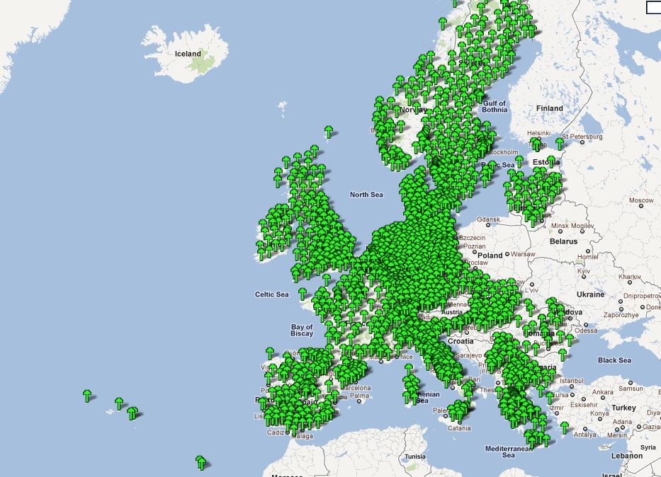
15 CORS Project References Regional 916 Sites Managed with Leica Spider Suite of Software Jenoba in Japan 600/1300 Sites 16

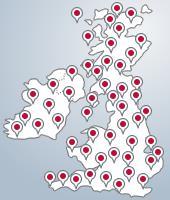
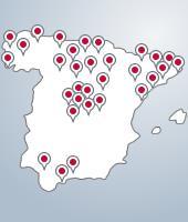
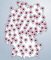
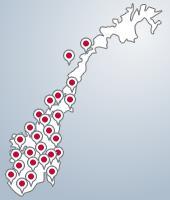
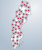
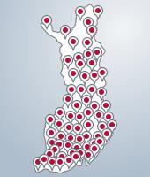
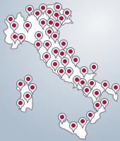
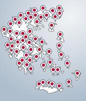
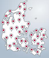
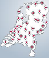
16 CORS Project References Europe Country Sites UK 130 Spain 38 Holland 43 Germany 267 Denmark 47 Norway 160 Sweden 160 Finland 58 Lithunia 18 Poland 27 Slovakia 27 Italy 232 Bulgaria 46 Greece 69 TOTAL >
17 18

18 CORS Project References Americas >1,100 SItes 36 US States 8 Canadian Provinces Mexico coming soon 19
19 FIG / UN-GGIM-AP / JUPEM Geospatial and GNSS CORS Infrastructure Forum Kuala Lumpur, Malaysia Oct 2016 Thank you
Leica GRX1200+ Series High Performance GNSS Reference Receivers
 Leica GRX1200+ Series High Performance GNSS Reference Receivers Leica GRX1200+ Series For permanent reference stations The Leica GRX1200+ Series, part of Leica's future proof System 1200, is designed specifically
Leica GRX1200 Series High Performance GNSS Reference Receivers
 Leica GRX1200 Series High Performance GNSS Reference Receivers Leica GRX1200 Series For permanent reference stations The Leica GRX1200 Series, part of Leica s new System 1200, is designed specifically
Leica Spider Infrastructure HW Solutions Introducing: Leica GR30 & GR50
 Leica Spider Infrastructure HW Solutions Introducing: Leica GR30 & GR50 Reliable solutions for today and tomorrow Leica Spider Integrated Solutions Introducing: Leica GR30 & GR50 Outline Introducing Leica
Who s heard of the GDA2020?
 Implications of a next generation datum in Australia on mining operations: A discussion. School of Civil & Environmental Engineering Craig Roberts Senior lecturer Surveying and Geospatial Engineering group
Guide to GNSS Base stations
 Guide to GNSS Base stations Outline Introduction Example of a base station (TUMSAT) Preparation for setting up a base station Procedure for setting up a base station Examples at two other universities
The Reasons to Succeed or to Fail a GNSS Network RTK Project
 The Reasons to Succeed or to Fail a GNSS Network RTK Project Joël van Cranenbroeck, Managing Director CGEOS Creative Geosensing sprl-s, Belgium Andy Yin, International Sales Director ComNav Technology
The Role of Positioning Infrastructure in the Technological Future of the Profession by Matt Higgins
 The Role of Positioning Infrastructure in the Technological Future of our Profession Matt Higgins Vice President Presentation Outline An explanation of Positioning Infrastructure; The Economic and Environmental
Combining Terrestrial and GNSS Technolgies for Geodetic Monitoring. Neil ASHCROFT Leica Geosystems Engineering Segment Manager
 Combining Terrestrial and GNSS Technolgies for Geodetic Monitoring Neil ASHCROFT Leica Geosystems Engineering Segment Manager Structural Monitoring Technolgies Introduction Monitoring Instrumentation Reflectors,
WHAT DOES FIG SURVEYORS EXPECT IN COLLABORATIVE PARTNERSHIP WITH IGS
 WHAT DOES FIG SURVEYORS EXPECT IN COLLABORATIVE PARTNERSHIP WITH IGS Larry D. Hothem, Past Chair, FIG Commission 5, Positioning and Measurement U.S. Geological Survey, Reston, Virginia, USA (Lhothem@usgs.gov)
The International Scene: How Precise Positioning Will Underpin Critical GNSS Applications
 The International Scene: How Precise Positioning Will Underpin Critical GNSS Applications School of Civil & Environmental Engineering, UNSW, Sydney, Australia Chris Rizos Member of the IGS Governing Board
CORSnet-NSW: Towards State-wide CORS Infrastructure for New South Wales, Australia
 CORSnet-NSW: Towards State-wide CORS Infrastructure for New South Wales, Australia Volker JANSSEN, Adrian WHITE and Thomas YAN, Australia Key words: CORSnet-NSW, infrastructure, Network RTK, datum, legal
ASG-EUPOS reference system
 Head Office of Geodesy and Cartography Department of Geodesy, Cartography and GIS ASG-EUPOS reference system Last year activities and future plans Szymon Wajda Prime specialist Bratislava, 21-22.11.2017
Precise Positioning... what does it mean? Precise GNSS Positioning Not just a niche technology. Chris Rizos 15/12/15
 Precise GNSS Positioning Not just a niche technology Chris Rizos Precise Positioning... what does it mean? 1 Precise Positioning... a spectrum of users... Few mm 1cm 2cm < dm 1dm sub-m Precision agriculture
Developing a National Real-time CORS Network in New Zealand
 Dave COLLETT, New Zealand Key words: GNSS, Positioning, CORS, New Zealand, Infrastructure SUMMARY Land Information New Zealand administers PositioNZ - New Zealand's national CORS network. This network
Alberding solutions for GNSS infrastructure operators
 Tamás Horváth Alberding solutions for GNSS infrastructure operators 21.11.2017 1/35 Alberding solutions for GNSS infrastructure operators Tamás Horváth Alberding GmbH 4 th EUPOS Technical Meeting 21-22
Philippine Geodetic Infrastructure Status, Challenges and Future Direction
 Philippine Geodetic Infrastructure Status, Challenges and Future Direction Engr. Charisma Victoria D. Cayapan National Mapping and Resource Information Authority PHILIPPINES Outline Evolution of Geodetic
Precise Positioning GNSS Applications
 Precise Point Positioning: Is the Era of Differential GNSS Positioning Drawing to an End? School of Surveying & Spatial Information Systems, UNSW, Sydney, Australia Chris Rizos 1, Volker Janssen 2, Craig
EUPOS: Unified GNSS Augmentation Infrastructure and International Cooperation in Central and Eastern Europe
 EUPOS: Unified GNSS Augmentation Infrastructure and International Cooperation in Central and Eastern Europe Senate Department for Urban Development Geodetic Reference Systems Fehrbelliner Platz 1, 10707
Geoscience & Positioning, Navigation and Timing Services for Canadians
 Geoscience & Positioning, Navigation and Timing Services for Canadians Calvin Klatt, Ph.D. Director and Chief Geodesist Natural Resources Canada / Directeur et géodésien principal Ressources naturelles
Report on a Multi-GNSS Demonstration project in the Asia/Oceania region
 Report on a Multi-GNSS Demonstration project in the Asia/Oceania region - Asia Oceania is the Showcase of New GNSS Era - Japan Aerospace Exploration Agency ICG 5@Turin, Italy October 19, 2010 1 Back Ground
Quasi-Zenith Satellite System (QZSS)
") Transmission of Augmentation Corrections using the Japanese QZSS for Real-Time Precise Point Positioning in Australia Ken Harima 1, Suelynn Choy 1, Mazher Choudhury 2, Chris Rizos 2, Satoshi Kogure 3 1
Transmission of Augmentation Corrections using the Japanese QZSS for Real-Time Precise Point Positioning in Australia Ken Harima 1, Suelynn Choy 1, Mazher Choudhury 2, Chris Rizos 2, Satoshi Kogure 3 1
al T TD ) ime D Faamily Products The RTD Family of products offers a full suite of highprecision GPS sensor positioning and navigation solutions for:
 ime D Faamily Products The RTD Family of products offers a full suite of highprecision GPS sensor positioning and navigation solutions for:") Reeal ynnamics al T amics (R TD ) ime D RTD) Time Dy Faamily mily ooff P roducts Products The RTD Family of products offers a full suite of highprecision GPS sensor positioning and navigation solutions
Reeal ynnamics al T amics (R TD ) ime D RTD) Time Dy Faamily mily ooff P roducts Products The RTD Family of products offers a full suite of highprecision GPS sensor positioning and navigation solutions
NTRIP Background History, Development & BKG. Networked Transport of RTCM via Internet Protocol
 Networked Transport of RTCM via Internet Protocol Networked Transport of RTCM via Internet Protocol Bundesamt für Kartographie und Geodäsie Motivation: Use Internet to transport GNSS corrections Communication
SUPPORT OF NETWORK FORMATS BY TRIMBLE GPSNET NETWORK RTK SOLUTION
 SUPPORT OF NETWORK FORMATS BY TRIMBLE GPSNET NETWORK RTK SOLUTION TRIMBLE TERRASAT GMBH, HARINGSTRASSE 19, 85635 HOEHENKIRCHEN, GERMANY STATUS The Trimble GPSNet network RTK solution was first introduced
Trimble NetR9 Reference Receiver Series: Frequently Asked Questions
 July 2010 Trimble NetR9 Reference Receiver Series: Frequently Asked Questions What is the Trimble NetR9 GNSS reference receiver? The Trimble NetR9 GNSS (Global Navigation Satellite System) reference receiver
Real-time PPP Results From Global Orbit and Clock Corrections
 BKG, Frankfurt a.m. Real-time PPP Results From Global Orbit and Clock Corrections Yüksel Altiner 1, Leos Mervart 2, Peter Neumaier 1, Wolfgang Söhne 1, Georg Weber 1 1 Federal Agency for Cartography and
Technical Specifications Document. for. Satellite-Based Augmentation System (SBAS) Testbed
 Testbed") Technical Specifications Document for Satellite-Based Augmentation System (SBAS) Testbed Revision 3 13 June 2017 Table of Contents Acronym Definitions... 3 1. Introduction... 4 2. SBAS Testbed Realisation...
Technical Specifications Document for Satellite-Based Augmentation System (SBAS) Testbed Revision 3 13 June 2017 Table of Contents Acronym Definitions... 3 1. Introduction... 4 2. SBAS Testbed Realisation...
Next Generation Positioning Infrastructure
 Next Generation Positioning Infrastructure The GNSS Network in the 21 st Century Joel VAN CRANENBROECK & Partners Beyond East & West GeoSensing Community 1 INFRASTRUCTURE "The installations that form the
MAGICGNSS RTCM-BASED SERVICE, A LEAP FORWARD TOWARDS MULTI- GNSS HIGH ACCURACY REAL-TIME PROCESSING
 ION GNSS 2015 MAGICGNSS RTCM-BASED SERVICE, A LEAP FORWARD TOWARDS MULTI- GNSS HIGH ACCURACY REAL-TIME PROCESSING SEPTEMBER 16 TH, 2015 - ION GNSS 2015, TAMPA, FLORIDA, USA SESSION E2A: NEXT GENERATION
SLX-1 Multi-Application GNSS Receiver
 SLX-1 Multi-Application GNSS Receiver w w w.sa tla b g p s. c o m SLX-1 Multi-Application GNSS Receiver Designed for CORS Ready for Anything European Standards GPS GLONASS BEIDOU GALILEO SBAS QZSS Long
The Future of GNSS RTK Services & Implications for CORS Infrastructure
 The Future of GNSS RTK Services & Implications for CORS Infrastructure Chris Rizos School of Surveying & Spatial information Systems University of New South Wales, Sydney 2052, Australia Abstract. A crucial
HEAD OFFICE OF GEODESY AND CARTOGRAPHY. Wspolna 2 Str., Warsaw, Poland ASG-EUPOS THE POLISH CONTRIBUTION TO THE EUPOS PROJECT
 HEAD OFFICE OF GEODESY AND CARTOGRAPHY Wspolna 2 Str., 00-926 Warsaw, Poland ASG-EUPOS THE POLISH CONTRIBUTION TO THE EUPOS PROJECT Project Part-Financed by European Union European Regional Development
The technical contribution of QZSS and GNSS to Tsunami early warning system
 0/17 Tsunami Workshop by Sentinel Asia @Sendai International Center Meeting Room 5 The technical contribution of QZSS and GNSS to Tsunami early warning system July 3, 2012 K. Mutoh, J. Yamashita, and S.
EUPOS - European Position Determination System Status and current issues
 EUPOS - European Position Determination System Status and current issues Office of the International EUPOS Steering Committee Senate Department for Urban Development, Land Berlin, Germany Symposium of
Innovation and Experience in GNSS Bridge Real Time 3D- Monitoring System
 Innovation and Experience in GNSS Bridge Real Time 3D- Monitoring System Joël van Cranenbroeck, Managing Director CGEOS Creative GeoSensing sprl-s Rue du Tienne de Mont, 11 5530 MONT, Belgium Transportation
Geodetic policy for Ireland and Northern Ireland
 Geodetic policy for Ireland and Northern Ireland Background Ordnance Survey Ireland (OSi) is the National Mapping Agency (NMA) of the Republic of Ireland. The Ordnance Survey of Northern Ireland (OSNI)
EXPERIMENTAL RESULTS OF LEX CORRECTIONS USING FARMING MACHINE
 Sixth Meeting of the International Committee on Global Navigation Satellite Systems (ICG) EXPERIMENTAL RESULTS OF LEX CORRECTIONS USING FARMING MACHINE Masayuki Kanzaki Hitachi Zosen Corporation Prof.
Trimble GNSS Infrastructure
 Trimble GNSS Infrastructure A History of Innovation Trimble, the first company to offer commercial GPS products company to integrate GPS with communications technology RTK system in the market in 1994
Record 2012/76 GeoCat 74975
 Record 2012/76 GeoCat 74975 Determination of GDA94 coordinates for station GRBA at the Goonyella Riverside Mine of the BHP Billiton Mitsubishi Alliance (BMA) in central Queensland using the September and
The GNSS Active Control Point Concept Get the {dynamic} Reference Points when You Need
 The GNSS Active Control Point Concept Get the {dynamic} Reference Points when You Need Joel van Cranenbroeck Chair of Commission 6 WG 6.2 International Federation of Surveyors (FIG) Belgium, Europa 2 3
GNSS Technology Update
 GNSS Technology Update Speaker: Eric Gakstatter Contributing Editor GPS World Editor - Geospatial Solutions Presented at: Association of Petroleum Surveying & Geomatics Houston, TX April 7, 2015 Agenda
Towards a EUREF Service Providing Real-time GNSS Clock and Orbit Corrections
 Towards a EUREF Service Providing Real-time GNSS Clock and Orbit Corrections G. Weber 1), W. Söhne 1), A. Stürze 1), L. Mervart 2) 1) Federal Agency for Cartography and Geodesy, Frankfurt am Main, Germany
Real-Time GNSS EUREF-IP Pilot Project
 Real-Time GNSS EUREF-IP Pilot Project G. Weber, BKG, Frankfurt 1. Status: Network, coverage, contributors 2. White Paper: Real-time GNSS in Routine EPN Operations 3. Real-time GNSS tools: BNC, client for
Determination of GDA94 coordinates for station PDM1 at BMA s Peak Downs Mine in central Queensland using the June 2013 GPS data set
 Record 2013/42 GeoCat 76764 Determination of GDA94 coordinates for station PDM1 at BMA s Peak Downs Mine in central Queensland using the G. Hu, J. Dawson APPLYING GEOSCIENCE TO AUSTRALIA S MOST IMPORTANT
Automated Frequency Response Measurement with AFG31000, MDO3000 and TekBench Instrument Control Software APPLICATION NOTE
 Automated Frequency Response Measurement with AFG31000, MDO3000 and TekBench Instrument Control Software Introduction For undergraduate students in colleges and universities, frequency response testing
GNSS Education Activities The University of Tokyo
 GNSS Education Activities The University of Tokyo Dinesh MANANDHAR, Associate Professor Center for Spatial Information Science, The University of Tokyo 6 th NOV 2018 dinesh@iis.u-tokyo.ac.jp Slide : 1
Accuracy assessment of free web-based online GPS Processing services and relative GPS solution software
 82 Accuracy assessment of free web-based online GPS Processing services and relative GPS solution software Khaled Mahmoud Abdel Aziz Department of Surveying Engineering, Shoubra Faculty of Engineering,
Record 2013/01 GeoCat 75057
 Record 2013/01 GeoCat 75057 Determination of GDA94 coordinates for station CCMB at the Clermont Coal Mine of Rio Tinto Coal Australia (RTCA) in central Queensland using the October and November 2012 GPS
Cross-Border EUPOS Data Exchange First Experience
 Cross-Border EUPOS Data Exchange First Experience Eimuntas Paršeliūnas, Marius Petniūnas, Domantas Bručas (Institute of Geodesy of Vilnius Gediminas Technical University, Lithuania) Wieslaw Graszka (Head
The Global Positioning System II Field Experiments
 The Global Positioning System II Field Experiments 5-1 Mexico DGPS Field Campaign Cenotes in Tamaulipas, MX, near Aldama 5-2 Are Cenote Water Levels Related? 5-3 DGPS Static Survey of Cenote Water Levels
TrigNet, South Africa s GNSS base station network: past, present and future
 TrigNet, South Africa s GNSS base station network: past, present and future Patrick Vorster 1, Stephan Koch 2 Chief Directorate: National Geospatial Information. Department of Rural Development and Land
How big is China s Digital Economy
 How big is China s Digital Economy Alicia Garcia Herrero Senior Fellow, Bruegel Jianwei Xu Beijing Normal University & Bruegel November 2017 Roadmap 1. Motivation 2. Internationally comparable measures
Record 2013/06 GeoCat 75084
 Record 2013/06 GeoCat 75084 Determination of GDA94 coordinates for station CAVL at the Caval Ridge Mine of RPS Australia East Pty Ltd in Queensland using the November 2012 GPS data set G. Hu, J. Dawson
Frame through-beam sensors
 Frame through-beam sensors Features Wide range of sizes: passage sizes from 25 x 23 mm to 300 x 397.5 mm Metal housings Integrated evaluation unit Connection by means of connector Degree of protection
THE CURRENT STATUS OF ASIA OCEANIA MULTI-GNSS DEMONSTRATION CAMPAIGN
 THE CURRENT STATUS OF ASIA OCEANIA MULTI-GNSS DEMONSTRATION CAMPAIGN 1 Multi-GNSS Asia Secretariat July 25, 2012 UN ICG WG-A intersession Mtg. Session4 @UWM Olstzyn, Poland ASIA OCEANIA MULTI-GNSS DEMONSTRATION
Template for CORS Networks
 Template for CORS Networks This template gives an idea on what can be included in the document or poster to describe the national or regional CORs network that your organisation is responsible for. The
Status of Multi-GNSS Monitoring Network Establishment
 Status of Multi-GNSS Monitoring Network Establishment Japan Aerospace Exploration Agency Satoshi Kogure ICG-6 6 WG-A/D cross-session session @Tokyo, JAPAN 7 September, 2011 Contents Introduction Overview
Tamás Horváth. 06 June 2012
 Tamás Horváth Software solutions for GNSS infrastructure monitoring 06 June 2012 1/18 Software solutions for GNSS infrastructure monitoring Tamás Horváth Alberding GmbH 06 June 2012 Tamás Horváth Software
Low Cost RF Sensors. application note
 Low Cost RF Sensors application note Application Note Table of Contents Introduction...3 Tektronix USB Spectrum Analyzers...3 Functional Block Diagram...3 The Two Programmatic Control Methods...4 Control
SERVIR: The Portuguese Army CORS Network for RTK
 SERVIR: The Portuguese Army CORS Network for RTK António Jaime Gago AFONSO, Rui Francisco da Silva TEODORO and Virgílio Brito MENDES, Portugal Key words: GNSS, RTK, VRS, Network ABSTRACT Traditionally
Indian Institute of Technology Kanpur Department of Civil Engineering
 Indian Institute of Technology Kanpur Department of Civil Engineering Inquiry No- CE/JNM/2013-14/R-10 30 December, 2013 Subject: Quotation for supply of Integrated System/Smart System Reflectorless Robotic
Ultra-Broadband Forum September 2015 Madrid, Spain
 Ultra-Broadband Forum 2015 8-9 September 2015 Madrid, Spain Ovum s Global Broadband Experience Scorecard Mark Newman, Chief Research Officer, Ovum mark.newman@ovum.com Introducing Ovum s Global Broadband
The Global Positioning Sytem II 10/19/2017
 The Global Positioning System II Field Experiments 10/19/2017 5-1 Mexico DGPS Field Campaign Cenotes in Tamaulipas, MX, near Aldama 10/19/2017 5-2 Are Cenote Water Levels Related? 10/19/2017 5-3 M. Helper,
Guide to GNSS Base stations
 Guide to GNSS Base stations Outline Introduction Example of Base Station (TUMSAT) Preparation for setting up a base station Procedure for setting up a base station Example of each Univ. Based on documents
Determination of GDA94 coordinates for eighteen C.R. Kennedy Survey Solutions stations using the July and August 2011 GPS data set
 G E O S C I E N C E A U S T R A L I A Determination of GDA94 coordinates for eighteen C.R. Kennedy Survey Solutions stations using the July and August 2011 GPS data set Jia, M. and Dawson, J. Record 2011/37
THE CURRENT STATUS OF ASIA OCEANIA MULTI-GNSS DEMONSTRATION CAMPAIGN. Multi-GNSS Asia Secretariat June 4 th, th ICG Providers Forum
 THE CURRENT STATUS OF ASIA OCEANIA MULTI-GNSS DEMONSTRATION CAMPAIGN 1 Multi-GNSS Asia Secretariat June 4 th, 2012 8 th ICG Providers Forum ASIA OCEANIA MULTI-GNSS DEMONSTRATION CAMPAIGN Multi-GNSS Monitoring
GNSS Receivers, Sensors, Desktop Solutions
 GNSS Receivers, Sensors, Desktop Solutions keep it simple high performance: the best GNSS tracking in field ready, reliable packages coupled with the best field and desktop software tools support and service
SLX-1 NG Multi-Application GNSS Receiver
 SLX-1 NG Multi-Application GNSS Receiver w w w.sa tla b g p s. c o m SLX-1 NG Multi-Application GNSS Receiver Designed for CORS Ready for Anything European Standards GPS GLONASS BEIDOU GALILEO SBAS QZSS
Monitoring Lecture ETH Zürich, Michael Rutschmann
 Monitoring Lecture 5.11.2008 ETH Zürich, Michael Rutschmann Monitoring lecture Contents 1. Monitoring System Intro 2. Different Setup of Monitoring Systems 3. GeoMoS (Monitor and Analyzer) 4. Setup of
Understanding Knowledge Societies Report of UNDESA/DPADM. Measurement Aspects. Irene Tinagli Tunis, 17 Nov World Summit on Information Society
 Understanding Knowledge Societies Report of UNDESA/DPADM Measurement Aspects by Irene Tinagli Tunis, 17 Nov. 2005 World Summit on Information Society About Measurement WHY? To assess & better understand
Report on GNSS Training
 Report on GNSS Training Course ID: T141-30 Afghanistan, Australia, Austria, Bangladesh, Bhutan, Cambodia, India, Indonesia, Japan, Maldives, Mongolia, Nepal, The Philippines, Sri Lanka, Tajikistan, Thailand,
SURVEYORS BOARD OF QUEENSLAND. RTK GNSS for Cadastral Surveys. Guideline
 SURVEYORS BOARD OF QUEENSLAND RTK GNSS for Cadastral Surveys Guideline 30 November 2012 RTK GNSS for Cadastral Surveys General The Surveyors Board of Queensland has recently become aware of some issues
Equipment List For GNSS Networks and Reference Stations
 Equipment List For GNSS Networks and Reference Stations GNSS Reference Station with GPS Spider Software Essential Items: For Data logging only: For transmitting RTK/DGPS data: a - Power supply l - Cable
Global and Regional Real-Time Infrastructure for open access use
 Global and Regional Real-Time Infrastructure for open access use Axel Rülke Federal Agency for Cartography and Geodesy Branch Office Leipzig, Germany Tutorial on (Open) Real-Time Infrastructure and Applications
SOURCE MEASURE UNITS. Make Multiple Measurements Accurately Using a Single Instrument All While Saving Space, Time and Money
 SOURCE MEASURE UNITS Make Multiple Measurements Accurately Using a Single Instrument All While Saving Space, Time and Money Do you use a power supply or digital multimeter? How about an electronic load,
RELEASE NOTES. Trimble. SPS Series Receivers. Introduction. New features and changes
 RELEASE NOTES Trimble SPS Series Receivers Introduction New features and changes Version 4.42 Revision A June 2011 F Corporate office Trimble Navigation Limited Engineering and Construction group 5475
PosKEN Related Activities in the Czech Republic
 Research Institute of Geodesy, Topography, and Cartography Geodetic Observatory Pecny Land Survey Office, Prague PosKEN Related Activities in the Czech Republic 2014-2015 National Report J. Šimek 1 and
Trimble GPSNet 2.5 Software for GNSS Infrastructure: New Features. Martin Janousek - Trimble Technical Support - Infrastructure
 Trimble GPSNet 2.5 Software for GNSS Infrastructure: New Features Martin Janousek - Trimble Technical Support - Infrastructure GPSNet Users Seminar Munich, March 30 th /31 th 2006 Overview Support for
Multi-GNSS real-time troposphere delay estimation
 Multi-GNSS real-time troposphere delay estimation Jaroslaw Bosy, Tomasz Hadas, Jak Kaplon, Kamil Kazmierski The 7th China Satellite Navigation Conference, May 18-20 Changsha China, Session S1: BDS/GNSS
SKPOS. Slovak real-time positioning service - a multifunctional tool for precise object and phenomena positioning
 SKPOS Slovak real-time positioning service - a multifunctional tool for precise object and phenomena positioning WHAT IS SKPOS AND HOW DOES IT WORK? Slovak real-time positioning service is a multifunctional
Through-beam ring sensors
 Throughbeam ring sensors Features Wide range of sizes: ring diameters of 10, 15 and 20 mm Metal housings Separate evaluation unit Connection by means of S8 connector Degree of protection IP 63 Adjustable
MXG X-Series Signal Generator N5183B Microwave Analog
 MXG X-Series Signal Generator N5183B Microwave Analog Configuration Guide This configuration guide will help you determine which performance, software applications, accessories, and services to include
Determination of GDA94 coordinates for eight stations of Ultimate Positioning Group Pty Ltd using the May 2013 GPS data set
 Record 2013/47 GeoCat 78541 Determination of GDA94 coordinates for eight stations of Ultimate Positioning Group Pty Ltd using the May 2013 GPS G. Hu, J. Dawson APPLYING GEOSCIENCE TO AUSTRALIA S MOST IMPORTANT
Facility. Development and Testing. What s Next? GNSS Modernization and Next Generation Hardware for the UNAVCO Community
 Facility Development and Testing What s Next? GNSS Modernization and Next Generation Hardware for the UNAVCO Community Frederick Blume UNAVCO Science Workshop, 9 March, 2010 Motivation Last formal hardware
Record 2011/02. GeoCat # M. Jia, J. Dawson APPLYING GEOSCIENCE TO AUSTR ALIA S MOST IMPORTANT CHALLENGES
 G E O S C I E N C E A U S T R A L I A Correction to Determination of GDA94 coordinates for eleven Queensland Department of Environment and Resource Management CORS stations using the August 2010 GPS data
Welcome to the IFR Press Conference 30 August 2012, Taipei
 Welcome to the IFR Press Conference 3 August 212, Taipei Continued success of the robotics industry Welcome by IFR President Dr. Shinsuke Sakakibara Presentation of the results of World Robotics 212 Industrial
GAVIN DOCHERTY & CRAIG ROBERTS School of Surveying & Spatial Information Systems. University of NSW
 FIG2010, Sydney, Australia 15 April 2010 The impact of Solar Cycle 24 on Network RTK in Australia GAVIN DOCHERTY & CRAIG ROBERTS School of Surveying & Spatial Information Systems University of NSW School
ADDENDUM NO. 2 DATE: August 14, Notice is hereby given of the following changes, Questions and Answers to the above referenced RFP:
 FLORIDA DEPARTMENT OF TRANSPORTATION Procurement Office 605 Suwannee Street, MS 20 Tallahassee, Florida 32399-0450 Phone: (850) 414-4568 Fax: (850) 414-4951 ADDENDUM NO. 2 DATE: August 14, 2012 RFP NO:
CHC MINING DEFORMATION MONITORING SOLUTION
 CHC MINING DEFORMATION MONITORING SOLUTION Safety is first in mining. CHC offers solutions designed to improve safety for personnel on the ground and in the cab with 24/7 precision positioning for automatic
The Global Positioning System II Field Experiments. 10/10/2013 GEO327G/386G, UT Austin 5-1
 The Global Positioning System II Field Experiments 10/10/2013 GEO327G/386G, UT Austin 5-1 Mexico DGPS Field Campaign Cenotes in Tamaulipas, MX, near Aldama 10/10/2013 GEO327G/386G, UT Austin 5-2 Are Cenote
Development of an Open Source Multi GNSS Data Processing Software
 2nd Asia Oceania Regional Workshop on GNSS 2010 Development of an Open Source Multi GNSS Data Processing Software Tomoji TAKASU Tokyo University of Marine Science and Technology Contents Introduction Issues
MGA Webinar Series : 1 Very Cheap RTK Receivers: Changing the Landscape of Positioning Services
 MGA Webinar Series : 1 Very Cheap RTK Receivers: Changing the Landscape of Positioning Services Dinesh Manandhar Center for Spatial Information Science The University of Tokyo Contact Information: dinesh@iis.u-tokyo.ac.jp
Session 1.2 Regional and National Reference Systems. Asia Pacific. Dr John Dawson Leader - National Geodesy Program Geoscience Australia
 Session 1.2 Regional and National Reference Systems Asia Pacific Dr John Dawson Leader - National Geodesy Program Geoscience Australia Presentation Overview Part 1 Australia s contributions to the ITRF
CORSnet-NSW. accurate reliable easy.
 CORSnet-NSW accurate reliable easy www.lpma.nsw.gov.au www.corsnet.com.au CORSnet-NSW supporting NSW farmers The NSW rural community is using precision agriculture techniques such as Variable Rate Applications,
AN AUSTRALIAN PILOT PROJECT FOR A REAL TIME KINEMATIC GPS NETWORK USING THE VIRTUAL REFERENCE STATION CONCEPT
 AN AUSTRALIAN PILOT PROJECT FOR A REAL TIME KINEMATIC GPS NETWORK USING THE VIRTUAL REFERENCE STATION CONCEPT Matthew B HIGGINS, Australia Key words: GPS, Surveying, Real Time Kinematic, Virtual Reference
Surveying in the Year 2020
 Surveying in the Year 2020 Johannes Schwarz Leica Geosystems My first toys 2 1 3 Questions Why is a company like Leica Geosystems constantly developing new surveying products and instruments? What surveying
Determination of GDA94 coordinates for fifteen CORSnet-NSW stations using the October 2012 GPS data sets
 Record 2013/10 GeoCat 75460 Determination of GDA94 coordinates for fifteen CORSnet-NSW stations using the October 2012 GPS data sets G. Hu, J. Dawson APPLYING GEOSCIENCE TO AUSTRALIA S MOST IMPORTANT CHALLENGES
ISG & ISPRS 2011, Sept , 2011 Shah Alam, MALAYSIA
 ISG & ISPRS 2011, Sept. 27-29, 2011 Shah Alam, MALAYSIA THE PERFORMANCE OF ISKANDARnet DGPS SERVICE Wan Aris. W. A. 1, Musa., T. A. 1, Othman. R 1 GNSS & Geodynamic Research Group, Faculty of Geoinformation
New Guide to GNSS Base stations
 New Guide to GNSS Base stations Asian Base Stations Project Updated on December 2017 Outline 1 st Chapter (page3 page25) -Setting of The Base Station- Introduction Example of base Station (TUMSAT) Preparation
PageNET: In Support of the Surveying Community
 Philippine Active Geodetic Network : In Support of the Surveying Community ICG Experts Meeting: Global Navigation Satellite Systems Services Vienna International Center, Vienna, Austria December 14-18,