Integrity Monitoring in a VRS Network
|
|
|
- Rosalind Norris
- 5 years ago
- Views:
Transcription
1 Integrity Monitoring in a VRS Network Bundesamt für Landestopografie Office fédéral de topographie Ufficio federale di topografia Uffizi federal da topografia Simon Grünig, swisstopo GPSNet User Conference, Munich, May 30-31, 2006

2 VRS-Monitor 23/05/2006 Folie m
3 Agenda AGNES Network Swiss Positioning Service (swipos ) Integrity Monitoring in a VRS Network, General Aspects The swisstopo VRS Monitor Measurements with the VRS Monitor Conclusion VRS-Monitor 23/05/2006 Folie 3
 Mean distance")

 Swiss Positioning")
4 AGNES Network Automatisches GPS-Netz Schweiz 30 stations (+ 9 stations from D, A) Mean distance between reference stations: 50 km Stations height distribution: m! Several applications National geodetic survey Science (atmosphere, geodynamics) Swiss Positioning Service VRS-Monitor 23/05/2006 Folie 4


5 Swipos Swiss Positioning Service swipos-gis/geo RTK-VRS accuracy 1-2 cm access by GSM and GPRS/NTRIP RTCM 3.0 user fee swipos-nav DGPS accuracy m access by GSM and GPRS/NTRIP RTCM 2.3 free of charge VRS-Monitor 23/05/2006 Folie 5
6 swipos Business Models strongly increasing number of GPRS/NTRIP users due to lower communication costs compared to classic GSM 80% of users accessing swipos by GPRS/NTRIP, 20% only by GSM classic 2 business models business number (GSM, 0.5 /minute) annual subscription (GPRS/NTRIP, 2000 ) 200 subscribed users ~ 50 occasional users (business number) VRS-Monitor 23/05/2006 Folie 6
7 Integrity Monitoring in a VRS Network (1) What is integrity? Integrity is the capacity of the system to alert the user within a predefined period of time ( Time to Alert ) whenever the system is not available for the current application. Moreover, integrity is the amount of confidence the user can have in the reliability of this information [1] [1] European Comission (2000), Galileo Definitions Document, GALA-DD092 VRS-Monitor 23/05/2006 Folie 7
8 Integrity Monitoring in a VRS Network (2) How is quality determined within GPSNet? coordinate monitoring troposphere monitoring network model integrity (iono and geo errors) Comparison (daily / hourly) with post-processing (scientific software Bernese 5.0) NTRIP-Monitor (IP Media Solutions, Gebhard) How is quality of user positioning determined? Rover Integrity??? Development of an VRS-Monitor by swisstopo VRS-Monitor 23/05/2006 Folie 8
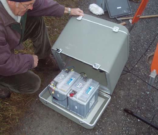
9 Requirements for the VRS Monitor simulation of a typical user at different locations 2 main uses: Integrity Monitoring (permanent) performance assessment (occasional) store raw data compare RTK positions (NMEA-GGA) to a ground truth send an alarm by or SMS if the alarm limit is reached mobile use waterproof (stored in a box) works in autonomous mode (battery and solar panel) VRS-Monitor 23/05/2006 Folie 9
10 Architecture VRS Monitor RTCM GPS Trimble 5700 GPS NMEA GGA Raw data GSM GPRS/NTRIP Swipos/GPSNet RTKMON - connects to GPSNet - receives and redirects RTCM - analyses NMEA-GGA - writes statistic files - creates graphics - sends alarms by /SMS VRS-Monitor GPSBase - stores raw data VRS-Monitor 23/05/2006 Folie 10

11 Software VRS Monitor, RTKMON VRS-Monitor 23/05/2006 Folie 11

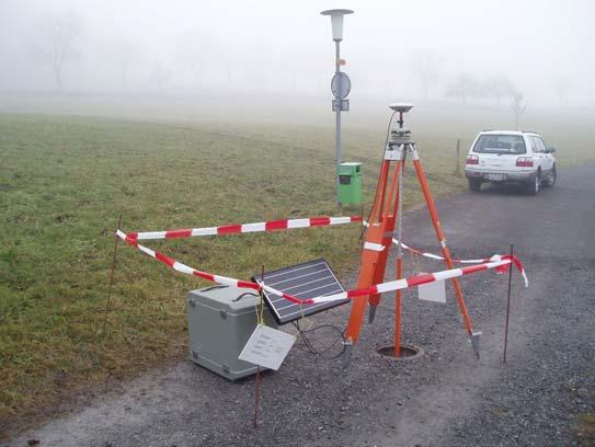
12 VRS Monitor in use VRS-Monitor 23/05/2006 Folie 12
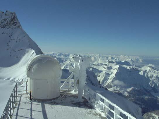
13 Measurments with the VRS Monitor simulation of different users permanent, roof swisstopo (1) ideal interpolation (2) extrapolation (3) height difference (4) impact of snow (5) VRS-Monitor 23/05/2006 Folie 13

![3 RMS [mm] 5.4 7.1 8.9 16.5 Initialization time [s] 20.](/docs-images/94/122325917/images/14-2.jpg "4 Outliers (> 3 cm Horizontal, > 6 cm height) : 1.")
14 Measurments with the VRS Monitor (1) Permanent, roof swisstopo, East North Horizontal Height Init Offset [mm] RMS [mm] Initialization time [s] 20.4 Outliers (> 3 cm Horizontal, > 6 cm height) : 1.4% VRS-Monitor 23/05/2006 Folie 14

![Horizontal Height Init Offset [mm] 6.9 8.0 10.](/docs-images/94/122325917/images/15-1.jpg "6 14.3 RMS [mm] 5.7 8.0 9.8 16.")
![1 Initialization time [s] 20.](/docs-images/94/122325917/images/15-2.jpg "8 Outliers (> 3 cm Horizontal, > 6 cm height)")
15 Measurments with the VRS Monitor (2) Ideal interpolation, Grenchen, 5 Days 2 East North Horizontal Height Init Offset [mm] RMS [mm] Initialization time [s] 20.8 Outliers (> 3 cm Horizontal, > 6 cm height) : 3.2% VRS-Monitor 23/05/2006 Folie 15

![9 RMS [mm] 7.2 3 10.7 12.9 26.6 Initialization time [s] 83.](/docs-images/94/122325917/images/16-2.jpg "5 Outliers (> 3 cm Horizontal, > 6 cm height) : 18.")
16 Measurments with the VRS Monitor (3) Extrapolation, Zermatt 5 Days East North Horizontal Height Init Offset [mm] RMS [mm] Initialization time [s] 83.5 Outliers (> 3 cm Horizontal, > 6 cm height) : 18.7 % VRS-Monitor 23/05/2006 Folie 16

![6 RMS [mm] 10.6 17.1 20.1 40.2 Initialization time [s] 46.](/docs-images/94/122325917/images/17-2.jpg "3 Outliers (> 3 cm Horizontal, > 6 cm height) : 24.")
17 Measurments with the VRS Monitor (4) Height difference, Brienz, 3 Days 4 East North Horizontal Height Init Offset [mm] RMS [mm] Initialization time [s] 46.3 Outliers (> 3 cm Horizontal, > 6 cm height) : 24.1 % VRS-Monitor 23/05/2006 Folie 17
, afterwards")

18 Measurments with the VRS Monitor (5) Impact of snow, San Bernardino, 4. Jan Feb 2006 AGNES Station SANB cleaned at beginning of test (zero reference), afterwards never cleaned again VRS-Monitor antenna (rover) cleaned after each snowfall connection time of VRS-Monitor 30 min distance between VRS-Monitor and reference 45 m VRS-Monitor 23/05/2006 Folie 18


![0 17.8 Initialization time [s] 22.](/docs-images/94/122325917/images/19-3.jpg "0 Outliers (> 3 cm Horizontal, > 6 cm height) :")
19 Measurments with the VRS Monitor (5) Impact of snow, San Bernardino, 4. Jan Feb East North Horizontal Height Init Offset [mm] RMS [mm] Initialization time [s] 22.0 Outliers (> 3 cm Horizontal, > 6 cm height) : 5 % VRS-Monitor 23/05/2006 Folie 19
 Impact of snow,")

20 Measurments with the VRS Monitor (5) Impact of snow, San Bernardino, 4. Jan Feb 2006 VRS-Monitor 23/05/2006 Folie 20
21 Measurments with the VRS Monitor Summary VRS method (GPSNet) gives good results and is distance independent as long as: no extrapolation occurs no big height difference occurs no other event like snow accumulation or thunderstorm occurs new station in Zermatt built last year to reduce extrapolation integration of other neighbourhood stations still ongoing new station in Bernese Oberland will be built this year to reduce the height problem besides the manual cleaning, other methods exist but have disadvantages automatic cleaning Radomes heating of the antenna etc. VRS-Monitor 23/05/2006 Folie 21
22 Conclusion VRS Monitor is the answer of swisstopo for Integrity Monitoring and performance assessment Other methods are necessary to ensure a full and reliable Integrity Monitoring Integrity Monitoring is a big issue in the positioning field Time to Alert still high Ideally, Integrity message should be on RTCM 3.0 corrections Within Galileo, Integrity is part of the system definition. What does this mean for positioning services? VRS-Monitor 23/05/2006 Folie 22
Enhancing the Swiss Permanent GPS Network (AGNES) for GLONASS
 for GLONASS") Enhancing the Swiss Permanent GPS Network (AGNES) for GLONASS D. INEICHEN, E. BROCKMANN, S. SCHAER 1 1 Abstract Since 1998 swisstopo has been operating the Automated GPS Network of Switzerland (AGNES)
Enhancing the Swiss Permanent GPS Network (AGNES) for GLONASS D. INEICHEN, E. BROCKMANN, S. SCHAER 1 1 Abstract Since 1998 swisstopo has been operating the Automated GPS Network of Switzerland (AGNES)
EUREF'02: National Report of Switzerland
 30 EUREF'0: National Report of Switzerland New Developments in Swiss National Geodetic Surveying D. SCHNEIDER, E. BROCKMANN, U. MARTI, A. SCHLATTER, TH. SIGNER, A. WIGET, U. WILD 1 1. Introduction The
Trimble GPSNet 2.5 Software for GNSS Infrastructure: New Features. Martin Janousek - Trimble Technical Support - Infrastructure
 Trimble GPSNet 2.5 Software for GNSS Infrastructure: New Features Martin Janousek - Trimble Technical Support - Infrastructure GPSNet Users Seminar Munich, March 30 th /31 th 2006 Overview Support for
Issues Related to the Use of Absolute GPS/GLONASS PCV Models
 Bundesamt für Landestopografie Office fédéral de topographie Ufficio federale di topografia Uffizi federal da topografia Issues Related to the Use of Absolute GPS/GLONASS PCV Models S. Schaer 1, U. Hugentobler
Trimble GNSS Infrastructure
 Trimble GNSS Infrastructure A History of Innovation Trimble, the first company to offer commercial GPS products company to integrate GPS with communications technology RTK system in the market in 1994
SERVIR: The Portuguese Army CORS Network for RTK
 SERVIR: The Portuguese Army CORS Network for RTK António Jaime Gago AFONSO, Rui Francisco da Silva TEODORO and Virgílio Brito MENDES, Portugal Key words: GNSS, RTK, VRS, Network ABSTRACT Traditionally
New Tools for Network RTK Integrity Monitoring
 New Tools for Network RTK Integrity Monitoring Xiaoming Chen, Herbert Landau, Ulrich Vollath Trimble Terrasat GmbH BIOGRAPHY Dr. Xiaoming Chen is a software engineer at Trimble Terrasat. He holds a PhD
Exploiting the high precision capabilities of the Hellenic Positioning System - HEPOS
 Exploiting the high precision capabilities of the Hellenic Positioning System - HEPOS M. Gianniou, D. Mastoris, I. Stavropoulou Geodetic Department KTIMATOLOGIO S.A. 339 Mesogion Ave., 15562 Holargos Greece
Utilizing A GNSS Network Solution for Utility Applications
 Utilizing A GNSS Network Solution for Utility Applications David Newcomer, PE, PLS GPServ, Inc. newcomer@ (407) 601-5816 AGENDA Types and accuracies of data collection o Autonomous o Meter + o Sub-meter
COMPARISON OF RELATIVE AND ABSOLUTE PRECISION OF OHIO S WIDE AREA GPS NETWORK INCLUDING THE COMPARISON WITH ALTERNATIVE METHODS.
 COMPARISON OF RELATIVE AND ABSOLUTE PRECISION OF OHIO S WIDE AREA GPS NETWORK INCLUDING THE COMPARISON WITH ALTERNATIVE METHODS A Thesis Presented in Partial Fulfillment of the Requirements for the Degree
International Foundation HFSJG Activity Report 2016
 Name of research institute or organization: Bundesamt für Landestopografie / Swiss Federal Office of Topography (swisstopo) Title of project: Automated GNSS Network Switzerland (AGNES) Project leader and
Fast convergence of Trimble CenterPoint RTX by regional augmentation
 Fast convergence of Trimble CenterPoint RTX by regional augmentation Dr. Ralf Drescher Trimble Terrasat GmbH, Munich EGU General Assembly 2015, Vienna Thursday, 16 April 2015 Outline Introduction CenterPoint
Processing Combined GPS/GLONASS Data at swisstopo s Local Analysis Center
 armasuisse Federal Office of Topography swisstopo Processing Combined GPS/GLONASS Data at swisstopo s Local Analysis Center D. Ineichen, E. Brockmann, S. Schaer GLONASS data used for EUREF solutions swisstopo
PosKEN Related Activities in the Czech Republic
 Research Institute of Geodesy, Topography, and Cartography Geodetic Observatory Pecny Land Survey Office, Prague PosKEN Related Activities in the Czech Republic 2014-2015 National Report J. Šimek 1 and
GNSS Low-Cost High-Accuracy Receiver (L-CHAR)
") GNSS Low-Cost High-Accuracy Receiver (L-CHAR) Dinesh Manandhar Center for Spatial Information Science The University of Tokyo Contact Information: dinesh@iis.u-tokyo.ac.jp Slide : 1 High Accuracy Receivers
GNSS Low-Cost High-Accuracy Receiver (L-CHAR) Dinesh Manandhar Center for Spatial Information Science The University of Tokyo Contact Information: dinesh@iis.u-tokyo.ac.jp Slide : 1 High Accuracy Receivers
GAVIN DOCHERTY & CRAIG ROBERTS School of Surveying & Spatial Information Systems. University of NSW
 FIG2010, Sydney, Australia 15 April 2010 The impact of Solar Cycle 24 on Network RTK in Australia GAVIN DOCHERTY & CRAIG ROBERTS School of Surveying & Spatial Information Systems University of NSW School
Federal Office of Topography swisstopo LPT (swisstopo) EPN analysis center and the switch to Bernese GNSS Software V5.2
 EPN analysis center and the switch to Bernese GNSS Software V5.2") LPT (swisstopo) EPN analysis center and the switch to Bernese GNSS Software V5.2 D. Ineichen, E. Brockmann, S. Schaer LPT s contribution for the EPN 52 stations (from France to Estonia) Development of
LPT (swisstopo) EPN analysis center and the switch to Bernese GNSS Software V5.2 D. Ineichen, E. Brockmann, S. Schaer LPT s contribution for the EPN 52 stations (from France to Estonia) Development of
CROPOS as Support of Geodetic Infrastructure in Croatia
 CROPOS as Support of Geodetic Infrastructure in Croatia Dr. Sc. Danko Markovinović - Croatia CLGE VicePresident The Geodetic Infrastructure in Europe - today and tomorrow Sweden...Umeå...22-23 June 2011
GPS: The Basics. Darrell R. Dean, Jr. Civil and Environmental Engineering West Virginia University. Expected Learning Outcomes for GPS
 GPS: The Basics Darrell R. Dean, Jr. Civil and Environmental Engineering West Virginia University Expected Learning Outcomes for GPS Explain the acronym GPS Name 3 important tdt dates in history of GPS
IMO WORLDWIDE RADIONAVIGATION SYSTEM (WWRNS) Study on Communication Techniques for High Accuracy DGPS in the Republic of Korea
 Study on Communication Techniques for High Accuracy DGPS in the Republic of Korea") INTERNATIONAL MARITIME ORGANIZATION E IMO SUB-COMMITTEE ON SAFETY OF NAVIGATION 52nd session Agenda item 12 NAV 52/INF.8 12 May 2006 ENGLISH ONLY WORLDWIDE RADIONAVIGATION SYSTEM (WWRNS) Study on Communication
INTERNATIONAL MARITIME ORGANIZATION E IMO SUB-COMMITTEE ON SAFETY OF NAVIGATION 52nd session Agenda item 12 NAV 52/INF.8 12 May 2006 ENGLISH ONLY WORLDWIDE RADIONAVIGATION SYSTEM (WWRNS) Study on Communication
European Position Determination System. Technical Standards
 European Position Determination System Technical Standards Revised 2 nd Edition 24 April 2008 Resolution of the International EUPOS Steering Committee 13 th Conference, Bucharest, Romania, 23 24 April
Monitoring with low-cost GNSS receivers
 Monitoring with low-cost GNSS receivers GNSS monitoring with low-cost receivers 1 Why GNSS? Your advantages! free of charge and available worldwide No line of sight connection is necessary to the measuring
Alberding solutions for GNSS infrastructure operators
 Tamás Horváth Alberding solutions for GNSS infrastructure operators 21.11.2017 1/35 Alberding solutions for GNSS infrastructure operators Tamás Horváth Alberding GmbH 4 th EUPOS Technical Meeting 21-22
RELEASE NOTES. Trimble. SPS Series Receivers. Introduction. New features and changes
 RELEASE NOTES Trimble SPS Series Receivers Introduction New features and changes Version 4.42 Revision A June 2011 F Corporate office Trimble Navigation Limited Engineering and Construction group 5475
NYSNET 11/28/2014 GPS/GLONASS (GG) January 2015 NYSAPLS Conference
 January 2015 NYSAPLS Conference") GPS/GLONASS (GG) January 2015 NYSAPLS Conference 2015 1 NYSNet 2015 GLONASS Upgrades Antenna Types Single Base/Network RTK GPS/GLONASS (GG) Single Base GPS/GLONASS (GG) Network RTK RT Products (NTRIP Mount
GPS/GLONASS (GG) January 2015 NYSAPLS Conference 2015 1 NYSNet 2015 GLONASS Upgrades Antenna Types Single Base/Network RTK GPS/GLONASS (GG) Single Base GPS/GLONASS (GG) Network RTK RT Products (NTRIP Mount
Introduction to GNSS Base-Station
 Introduction to GNSS Base-Station Dinesh Manandhar Center for Spatial Information Science The University of Tokyo Contact Information: dinesh@iis.u-tokyo.ac.jp Slide : 1 Introduction GPS or GNSS observation
Positioning Techniques. João F. Galera Monico - UNESP Tuesday 12 Sep
 Positioning Techniques João F. Galera Monico - UNESP Tuesday 12 Sep Positioning methods Absolute Positioning Static and kinematic SPP and PPP Relative Positioning Static Static rapid Semi kinematic Kinematic
NTRIP Background History, Development & BKG. Networked Transport of RTCM via Internet Protocol
 Networked Transport of RTCM via Internet Protocol Networked Transport of RTCM via Internet Protocol Bundesamt für Kartographie und Geodäsie Motivation: Use Internet to transport GNSS corrections Communication
CHC MINING DEFORMATION MONITORING SOLUTION
 CHC MINING DEFORMATION MONITORING SOLUTION Safety is first in mining. CHC offers solutions designed to improve safety for personnel on the ground and in the cab with 24/7 precision positioning for automatic
Latest Developments in Network RTK Modeling to Support GNSS Modernization
 Journal of Global Positioning Systems (2007) Vol.6, No.1: 47-55 Latest Developments in Network RTK Modeling to Support GNSS Modernization Herbert Landau, Xiaoming Chen, Adrian Kipka, Ulrich Vollath Trimble
Combining Terrestrial and GNSS Technolgies for Geodetic Monitoring. Neil ASHCROFT Leica Geosystems Engineering Segment Manager
 Combining Terrestrial and GNSS Technolgies for Geodetic Monitoring Neil ASHCROFT Leica Geosystems Engineering Segment Manager Structural Monitoring Technolgies Introduction Monitoring Instrumentation Reflectors,
DYNAMIC RT TECHNOLOGY
 DYNAMIC RT TECHNOLOGY GLOBAL NAVIGATION SATELLITE SYSTEMS (GNSS) POTENTIAL FUTURE DEVELOPMENTS(2005 2017?) GPS MODERNIZATION BLOCK IIF & III GLONASS ENHANCEMENTS (K & M) EUROPEAN UNION - GALILEO CHINA
Presentation Plan. The Test of Processing Modules of Global Positioning System (GPS) Softwares by Using Products of International GPS Service (IGS)
 Softwares by Using Products of International GPS Service (IGS)") The Test of Processing Modules of Global Positioning System (GPS) Softwares by Using Products of International GPS Service (IGS) Presentation Plan 1. Introduction 2. Application 3. Conclusions Ismail SANLIOGLU,
The Test of Processing Modules of Global Positioning System (GPS) Softwares by Using Products of International GPS Service (IGS) Presentation Plan 1. Introduction 2. Application 3. Conclusions Ismail SANLIOGLU,
SUPPORT OF NETWORK FORMATS BY TRIMBLE GPSNET NETWORK RTK SOLUTION
 SUPPORT OF NETWORK FORMATS BY TRIMBLE GPSNET NETWORK RTK SOLUTION TRIMBLE TERRASAT GMBH, HARINGSTRASSE 19, 85635 HOEHENKIRCHEN, GERMANY STATUS The Trimble GPSNet network RTK solution was first introduced
MGA Webinar Series : 1 Very Cheap RTK Receivers: Changing the Landscape of Positioning Services
 MGA Webinar Series : 1 Very Cheap RTK Receivers: Changing the Landscape of Positioning Services Dinesh Manandhar Center for Spatial Information Science The University of Tokyo Contact Information: dinesh@iis.u-tokyo.ac.jp
Specifications. Trimble BX982 Modular GNSS Heading Receiver
 Name Configuration Option Base and Rover interchangeability Rover position update rate Rover maximum range from base radio Rover operation within a VRS network Heading and Moving Base operation Factory
Rapid Static Positioning Using GPS and GLONASS
 armasuisse Rapid Static Positioning Using GPS and GLONASS S. C. Schaer 1, E. Brockmann 1, M. Meindl 2 1 Swiss Federal Office of Topography (swisstopo) 2 Astronomical Institute of the University of Berne
Trimble Business Center:
 Trimble Business Center: Modernized Approaches for GNSS Baseline Processing Trimble s industry-leading software includes a new dedicated processor for static baselines. The software features dynamic selection
Tersus RTK Competitive Analysis
 Test Report Jun 2018 Tersus RTK Competitive Analysis 2018 Tersus GNSS Inc. All rights reserved. Sales & Technical Support: sales@tersus-gnss.com & support@tersus-gnss.com More details, please visit www.tersus-gnss.com
al T TD ) ime D Faamily Products The RTD Family of products offers a full suite of highprecision GPS sensor positioning and navigation solutions for:
 ime D Faamily Products The RTD Family of products offers a full suite of highprecision GPS sensor positioning and navigation solutions for:") Reeal ynnamics al T amics (R TD ) ime D RTD) Time Dy Faamily mily ooff P roducts Products The RTD Family of products offers a full suite of highprecision GPS sensor positioning and navigation solutions
Reeal ynnamics al T amics (R TD ) ime D RTD) Time Dy Faamily mily ooff P roducts Products The RTD Family of products offers a full suite of highprecision GPS sensor positioning and navigation solutions
Some experiences of Network-RTK in the SWEPOS network
 75 Some experiences of Network-RTK in the SWEPOS network B. JONSSON, G. HEDLING, P. WIKLUND 1 Abstract SWEPOS, the Swedish network of permanent reference stations, is in operation since 1998 and provides
Guide to GNSS Base stations
 Guide to GNSS Base stations Outline Introduction Example of a base station (TUMSAT) Preparation for setting up a base station Procedure for setting up a base station Examples at two other universities
A Differential Reference Station Algorithm For Modular Decentralized GPS/GNSS Master Station Architecture. Oct. 28, 2010
 212-1-29 International Symposium on GPS/GNSS 21 Oct. 26-28, National Cheng Kung Univ., Taiwan A Differential Reference Station Algorithm For Modular Decentralized GPS/GNSS Master Station Architecture Oct.
Proposed standard for permanent GNSS reference stations in the Nordic countries
 Version 0.6 2003-05-15 Proposed standard for permanent GNSS reference stations in the Nordic countries Introduction Subproject A0 of the project Nordic Real-time Positioning Service Gunnar Hedling, Finn
The Reasons to Succeed or to Fail a GNSS Network RTK Project
 The Reasons to Succeed or to Fail a GNSS Network RTK Project Joël van Cranenbroeck, Managing Director CGEOS Creative Geosensing sprl-s, Belgium Andy Yin, International Sales Director ComNav Technology
NORDISKA KOMMISSIONEN FÖR GEODESI
 NORDISKA KOMMISSIONEN FÖR GEODESI Ordförande BJøRN ENGEN Statens Kartverk Kartverksvn 21 N-3500 Hønefoss NORGE Sekreterare BO JONSSON Lantmäteriverket LF-Geodesi SE-801 82 Gävle SVERIGE The NKG Steering
Monitoring Lecture ETH Zürich, Michael Rutschmann
 Monitoring Lecture 5.11.2008 ETH Zürich, Michael Rutschmann Monitoring lecture Contents 1. Monitoring System Intro 2. Different Setup of Monitoring Systems 3. GeoMoS (Monitor and Analyzer) 4. Setup of
RTK Rover Performance using the Master- Auxiliary Concept
 RTK Rover Performance using the Master- Auxiliary Concept N. Brown, I. Geisler and L. Troyer Networked Reference Stations and Structural Monitoring Leica Geosystems, Heinrich-Wild-Strasse, Heerbrugg, 9435,
Accuracy Evaluation Internet-Based GNSS for Kinematic Surveying the Case Study in Thailand
 Accuracy Evaluation Internet-Based GNSS for Kinematic Surveying the Case Study in Thailand Kritsada Anantakarn 1 1 Faculty of Engineering and Architectural : Uthenthawai campus. Rajamongala University
National Report of Greece to EUREF 2009
 National Report of Greece to EUREF 2009 M. Gianniou KTIMATOLOGIO S.A. (Hellenic Cadastre) 1 Introduction In 2007, KTIMATOLOGIO S.A (Hellenic Cadastre) established HEPOS, the HEllenic POsitioning System,
When do you expect Athena to be available for VS330? This is currently being beta-tested and will be released in the very near future.
 Why Athena? Athena GNSS Engine What improvements does Athena offer over the RTK firmware I m running now? Compared to the Hemisphere firmware most users are currently using (Qf4), there are significant
FIELD TEST OF THE GPS+GLONASS RTK AT THE CAGLIARI PERMANENT STATION VIA INTERNET. Giannina Sanna, Giuseppina Vacca
 FIELD TEST OF THE GPS+GLONASS RTK AT THE CAGLIARI PERMANENT STATION VIA INTERNET Giannina Sanna, Giuseppina Vacca University of Cagliari Department of Structural Engineering P.zza D Armi 913 Cagliari,
Precise Instantaneous Network Positioning
 Precise Instantaneous Network Positioning Direct and Inverse Network RTK Approaches Yehuda Bock, Jeff Fayman, David Honcik, Paul de Jonge, Lydia Bock Geodetics, Inc. La Jolla, California ION GNSS 2005
DYNAMIC STATION COORDINATES APPROACH TO IMPROVE NETWORK/FIELD PERFORMANCE
 DYNAMIC STATION COORDINATES APPROACH TO IMPROVE NETWORK/FIELD PERFORMANCE AUTHOR: STEPHAN BLATT, JUAN ERENCIA-GUERRERO TRIMBLE TERRASAT GMBH, HARINGSTRAßE 19, 85635 HÖHENKIRCHEN-SIEGERTSBRUNN, GERMANY
GPSNet. Some remarks from SAPOS Operators using
 Some remarks from SAPOS Operators using GPSNet of the representatives of state survey authorities Walter Lindstrot, Nordrhein-Westfalen (NRW), Andreas Brünner, Bayern (BY), Hans-Georg Dick, Baden-Württemberg
EUREF Related Activities in the Czech Republic
 Research Institute of Geodesy, Topography, and Cartography Geodetic Observatory Pecny Land Survey Office, Prague EUREF Related Activities in the Czech Republic 2012-2013 National Report J. Šimek 1, J.
RTK Rover Performance using the Master-Auxiliary Concept
 Journal of Global Positioning Systems (2006) Vol. 5, No. 1-2:135-144 RTK Rover Performance using the Master-Auxiliary Concept N. Brown, I. Geisler and L. Troyer Networked Reference Stations and Structural
Trimble NetR9 Reference Receiver Series: Frequently Asked Questions
 July 2010 Trimble NetR9 Reference Receiver Series: Frequently Asked Questions What is the Trimble NetR9 GNSS reference receiver? The Trimble NetR9 GNSS (Global Navigation Satellite System) reference receiver
FieldGenius Technical Notes GPS Terminology
 FieldGenius Technical Notes GPS Terminology Almanac A set of Keplerian orbital parameters which allow the satellite positions to be predicted into the future. Ambiguity An integer value of the number of
Assessing the Impact of the SCIGN Radome on Geodetic Parameter Estimates
 Assessing the Impact of the SCIGN Radome on Geodetic Parameter Estimates John J. Braun UCAR/COSMIC Program P.O. Box 3000, Boulder, CO braunj@ucar.edu 303.497.8018 Introduction The SCIGN radome is widely
Cost-effective precise positioning for geospatial applications
 Cost-effective precise positioning for geospatial applications Octavian Andrei Department of Survey Engineering, Chulalongkorn University, Thailand IPNTJ Summaer School 2014 Jul 28 Aug 02, Total Value
Next Generation Positioning Infrastructure
 Next Generation Positioning Infrastructure The GNSS Network in the 21 st Century Joel VAN CRANENBROECK & Partners Beyond East & West GeoSensing Community 1 INFRASTRUCTURE "The installations that form the
International Journal of Scientific & Engineering Research, Volume 6, Issue 8, August ISSN
 International Journal of Scientific & Engineering Research, Volume 6, Issue 8, August-2015 683 Assessment Accuracy of Static Relative Positioning Using Single Frequency GPS Receivers Mahmoud I. El-Mewafi
TrigNet: The South African Network of Continuously Operating GNSS Base Stations
 TrigNet: The South African Network of Continuously Operating GNSS Base Stations R Wonnacott ESESA User Need Workshop Thread 2: Status of Current GNSS Applications in South Africa Somerset West 2 March
Using RTK GNSS Wisely
 Using RTK GNSS Wisely February 017 Autonomous Positioning Differential Positioning Concept: Detect and cancel identical errors with simultaneous observation. F + E = G + E 1 Static & RTK Computations Static
RELEASE NOTES. Trimble Infrastructure GNSS Series Receivers. Introduction. New features or changes. Updating the firmware
 RELEASE NOTES Trimble Infrastructure GNSS Series Receivers Introduction New features or changes Updating the firmware Version 4.42 Revision A June 2011 F Corporate office Trimble Navigation Limited Engineering
Specifications. Trimble SPS985 GNSS Smart Antenna
 Receiver Name Configuration Option Base and Rover interchangeability Rover position update rate Rover maximum range from base radio Rover operation within a VRS network Heading and Moving Base operation
Does GNSS outperform GPS in Geodetic Applications?
 Contribution to Conference Proceedings of POSITIONs 008, Dresden 7.-9.10.008 Does GNSS outperform GPS in Geodetic Applications? Asim Bilajbegović, Prof. Dr.-Ing. 1, Rüdiger Lehmann, Prof. Dr.-Ing. 1, University
Leica GRX1200 Series High Performance GNSS Reference Receivers
 Leica GRX1200 Series High Performance GNSS Reference Receivers Leica GRX1200 Series For permanent reference stations The Leica GRX1200 Series, part of Leica s new System 1200, is designed specifically
ISG & ISPRS 2011, Sept , 2011 Shah Alam, MALAYSIA
 ISG & ISPRS 2011, Sept. 27-29, 2011 Shah Alam, MALAYSIA THE PERFORMANCE OF ISKANDARnet DGPS SERVICE Wan Aris. W. A. 1, Musa., T. A. 1, Othman. R 1 GNSS & Geodynamic Research Group, Faculty of Geoinformation
Affordable Differential GPS. Ben Nizette and Andrew Tridgell Australian National University CanberraUAV
 Affordable Differential GPS Ben Nizette and Andrew Tridgell Australian National University CanberraUAV Better positioning cheaply! Very accurate GPS systems are possible, but expensive Can we build one
EFFECTS OF IONOSPHERIC SMALL-SCALE STRUCTURES ON GNSS
 EFFECTS OF IONOSPHERIC SMALL-SCALE STRUCTURES ON GNSS G. Wautelet, S. Lejeune, R. Warnant Royal Meteorological Institute of Belgium, Avenue Circulaire 3 B-8 Brussels (Belgium) e-mail: gilles.wautelet@oma.be
GeoMax GNSS Zenith10 & Zenith20 Series
 GeoMax GNSS Zenith10 & Zenith20 Series GeoMax About Us At GeoMax we provide a com- group with strong market At GeoMax, we concentrate on prehensive portfolio of inte- positions within measurement providing
GNSS 101 Bringing It Down To Earth
 GNSS 101 Bringing It Down To Earth Steve Richter Frontier Precision, Inc. UTM County Coordinates NGVD 29 State Plane Datums Scale Factors Projections Session Agenda GNSS History & Basic Theory Coordinate
Sogei R&D for GNSS Institutional Application Development
 Sogei R&D for GNSS Institutional Application Development The content of the document, including all the information, data, communications, code, graphics, text, tables, images, photos, videos, music, drawings,
Performance Evaluation of Differential Global Navigation Satellite System with RTK Corrections
 IOSR Journal of Electronics and Communication Engineering (IOSR-JECE) e-issn: 2278-2834,p- ISSN: 2278-8735.Volume 9, Issue 2, Ver. VI (Mar - Apr. 2014), PP 43-47 Performance Evaluation of Differential
Leica MNS1200 GNSS Series Toughest GNSS solution for toughest sites
 Leica MNS1200 GNSS Series Toughest GNSS solution for toughest sites >Fast >Smart >Integrated Leica MNS1200 GNSS Series Robust GNSS machine navigation solution The Leica MNS1200 GNSS (Global Navigation
DEVICE CONFIGURATION INSTRUCTIONS. WinFrog Device Group:
 WinFrog Device Group: Device Name/Model: Device Manufacturer: Device Data String(s) Output to WinFrog: WinFrog Data String(s) Output to Device: WinFrog Data Item(s) and their RAW record: GPS NMEA GPS (Sercel)
EUREF Related Activities in the Czech Republic
 Research Institute of Geodesy, Topography, and Cartography Geodetic Observatory Pecny Land Survey Office, Prague EUREF Related Activities in the Czech Republic 2014-2015 National Report J. Douša 1, V.
RELEASE NOTES. Trimble. SPS Series Receivers. Introduction. Changes to all products. Additional changes to the SPSx81 Smart GPS antennas
 RELEASE NOTES Trimble SPS Series Receivers Introduction Changes to all products Additional changes to the SPSx81 Smart GPS antennas Additional changes to the SPSx51 Modular GPS receivers and SPSx61 Heading
USER MANUAL FIELDBEE AND RTK BEE STATION FULL VERSION. WE PROVIDE ONLINE SUPPORT: VERSION 1.0.
 USER MANUAL FULL VERSION VERSION 1.0. FIELDBEE AND RTK BEE STATION WE PROVIDE ONLINE SUPPORT: support@efarmer.mobi info@efarmer.mobi CONTENTS TABLE OF CONTENTS INTRODUCTION... 3 3 WAYS OF USING FIELDBEE...
Intuicom. RTK Bridge -M Installation Guide. For. Trimble AgGPS 252 and 262
 Intuicom RTK Bridge -M Installation Guide For Trimble AgGPS 252 and 262 Intuicom, Inc. 4900 Nautilus Ct. Ste. 100 Boulder, CO 80301 (303) 449-4330 www.intuicom.com This Document is for internal use by
Leica GRX1200 Series Technical Data
 Leica GRX1200 Series Technical Data GRX1200 Series Technical Data Summary Description GRX1200 Lite GRX1200 Classic GRX1200 GG Pro Continuously Operating Reference Station (CORS) GPS GNSS Survey, geodetic,
Implementation of New Positioning System in Riga
 Implementation of New Positioning System in Riga M.Abele (1), J.Balodis (1), K.Balodis (1), M.Caunite (1), I.Janpaule (1), A.Rubans (1), G.Silabriedis (1,2), I.Mitrofanovs(2), A.arinsjh (1) (1) University
METIS Second Master Training & Seminar. Augmentation Systems Available in Egypt
 METIS Second Master Training & Seminar Augmentation Systems Available in Egypt By Eng. Ramadan Salem M. Sc. Surveying and Geodesy Email: ramadan_salem@link.net Page 1 Augmentation Systems Available in
HEAD OFFICE OF GEODESY AND CARTOGRAPHY. Wspolna 2 Str., Warsaw, Poland ASG-EUPOS THE POLISH CONTRIBUTION TO THE EUPOS PROJECT
 HEAD OFFICE OF GEODESY AND CARTOGRAPHY Wspolna 2 Str., 00-926 Warsaw, Poland ASG-EUPOS THE POLISH CONTRIBUTION TO THE EUPOS PROJECT Project Part-Financed by European Union European Regional Development
C94-M8P Application Board Setup Guide
 C94-M8P Application Board Setup Guide locate, communicate, accelerate UBX-16009722 R02 C94-M8P Board Connections and Interfaces J1 J10 J2 J3 J1: RS232 UART M8P/Radio J2: USB M8P J3: External battery /
RTN Measurements Accuracy Test in Reference to MSPP**
 GEOMATICS AND ENVIRONMENTAL ENGINEERING Volume 3 Number 2 2009 Andrzej Uznañski* RTN Measurements Accuracy Test in Reference to MSPP** 1. Introduction In the recent years, the Real Time Kinematic measurements
PERFORMANCE OF REGIONAL ATMOSPHERIC ERROR MODELS FOR NRTK IN GPSnet AND THE IMPLEMENTATION OF A NRTK SYSTEM
 PERFORMANCE OF REGIONAL ATMOSPHERIC ERROR MODELS FOR NRTK IN GPSnet AND THE IMPLEMENTATION OF A NRTK SYSTEM A thesis submitted in partial fulfilment of the requirements for the degree of Doctor of Philosophy
SL 300 GNSS Receiver. w w w. s a t l a b g p s. c o m
 SL 300 GNSS Receiver w w w. s a t l a b g p s. c o m SL 300 6G GNSS Receiver The Ultimate Expandable Handheld Smart GNSS Sensor with 6G Tracking European Standards Lightweight Bluetooth GPS GLONASS BEIDOU
GNSS High Precision Systems for Cadastre: development, experiences and Galileo perspectives
 GNSS High Precision Systems for Cadastre: development, experiences and Galileo perspectives CLGE Plenary Workshop 29 September 2017 Roberto Capua, Flavio Ferrante DO-11-DO-03 1 Agenda GNSS High Precision
SKPOS. Slovak real-time positioning service - a multifunctional tool for precise object and phenomena positioning
 SKPOS Slovak real-time positioning service - a multifunctional tool for precise object and phenomena positioning WHAT IS SKPOS AND HOW DOES IT WORK? Slovak real-time positioning service is a multifunctional
Ionospheric Disturbance Indices for RTK and Network RTK Positioning
 Ionospheric Disturbance Indices for RTK and Network RTK Positioning Lambert Wanninger Geodetic Institute, Dresden University of Technology, Germany BIOGRAPHY Lambert Wanninger received his Dipl.-Ing. and
National report of Finland
 National report of Finland Matti Ollikainen, Jorma Jokela, Markku Poutanen, Ruizhi Chen and Jaakko Mäkinen, Finnish Geodetic Institute, P.O.Box 15, 02431 Masala, Finland EUREF Symposium 2006, June 14-17,
GIS Mapping with SiReNT Real-time Differential GPS
 GIS Mapping with SiReNT Real-time Differential GPS Victor KHOO Hock Soon ABSTRACT Singapore Land Authority No.8, Shenton Way #26-01 Singapore 068811 Email: Victor_khoo@sla.gov.sg Accurate and up-to-date
Towards a EUREF Service Providing Real-time GNSS Clock and Orbit Corrections
 Towards a EUREF Service Providing Real-time GNSS Clock and Orbit Corrections G. Weber 1), W. Söhne 1), A. Stürze 1), L. Mervart 2) 1) Federal Agency for Cartography and Geodesy, Frankfurt am Main, Germany
Template for CORS Networks
 Template for CORS Networks This template gives an idea on what can be included in the document or poster to describe the national or regional CORs network that your organisation is responsible for. The
Space Weather and the Ionosphere
 Dynamic Positioning Conference October 17-18, 2000 Sensors Space Weather and the Ionosphere Grant Marshall Trimble Navigation, Inc. Note: Use the Page Down key to view this presentation correctly Space
ProMark 3 RTK. White Paper
 ProMark 3 RTK White Paper Table of Contents 1. Introduction... 1 2. ProMark3 RTK Operational Environment... 2 3. BLADE TM : A Unique Magellan Technology for Quicker Convergence... 3 4. ProMark3 RTK Fixed
DGPS navigation service based on VRS with local EGNOS back-up
 DGPS navigation service based on VRS with local EGNOS back-up EGNOS SERVICE PROVISION WORKSHOP, Warsaw, 27-28 September 2016 Michael Hoppe German Federal Waterways and Shipping Administration Overview