Affordable Differential GPS. Ben Nizette and Andrew Tridgell Australian National University CanberraUAV
|
|
|
- Evelyn Copeland
- 6 years ago
- Views:
Transcription

1 Affordable Differential GPS Ben Nizette and Andrew Tridgell Australian National University CanberraUAV


2 Better positioning cheaply! Very accurate GPS systems are possible, but expensive Can we build one cheaply? Needed for: accurate UAV flight swarming quadcopters accurate ground rovers


3 How does GPS work? Clocks in the sky each satellite broadcasts a time signal, plus orbit information receivers calculate 'pseudoranges' to visible satellites receivers triangulate their position least-squares solution in 4 dimensions (position+time) Phase information more accuracy by tracking 'carrier phase' need to disambiguate solution as multiple of 19cm wavelength
4 How accurate is GPS? It depends on how much you spend! 'base' GPS in Australia is around 10m error horizontally (for around $50) in US, Europe and Japan SBAS (Satellite Based Augmentation System) can reduce error to around 3m dual frequency GPS receivers can do a lot better, but cost more than $2k for a cheap one with a source of corrections and dual-frequency 10cm accuracy is common with great corrections and a $10k receiver you can get better than 1cm Or how much CPU you have Possible to run open source RTK solutions (like RTKlib) if you have enough CPU power in on a ground station and on the rover.
5 Sources of GPS error Major error sources mismatch between ionospheric model and actual conditions 'space weather' - largely solar activity multi-pathing dynamic model mismatch to real movement bugs in code and standards (can be arbitrarily large!) tropospheric errors antenna errors clock errors orbital errors
6 Differential GPS Major errors are spatially correlated two receivers that are close to each other see the same ionospheric errors This is the basis for how DGPS works Steps in DGPS Use a reference station to measure error assumes you know the true position of the reference Send measured errors to 'rover' Rover subtracts errors from its pseudoranges Rover performs normal triangulation with corrected ranges How much can it help? Expected improvement is roughly 50% to 70% reduction in horizontal errors
7 Raw receivers For DGPS we need a 'raw capable' receiver A 'raw capable' receiver gives the pseudoranges and carrier phase in the local protocol These pseudoranges are combined with reference position to calculate the per-satellite corrections Raw capable receivers are more expensive cheapest is around $80 for a ublox-6t much cheaper than commercial DGPS reference stations, which cost many thousands
8 Constructing the corrections We know the reference station position exactly, but not time From the pseudoranges and reference position, we solve for the receiver's clock error What's left can be directly compared to the geometric range between the receiver and satellite The difference is the error Cheap receivers can accept corrections in RTCMv2 format Modelled after the GPS satellite format, very hard to work with! Contains pseudorange corrections, rates, estimated satellite qualities

9 Infrastructure references - NTRIP
10 NTRIP to RTCMv2 Geoscience Australia also generates corrections Some stations require a fee, some are free to use for non-commercial purposes (if you ask nicely!) Available in NTRIP (encapsulated RTCMv3) Need to convert between v3 from GA and v2 for the receivers RTCMv3 doesn't provide corrections directly Provides observations at reference point Similar to raw receiver outputs but corrected for receiver clock error We know both where the reference is and when it is Can then difference the geometric ranges and observed pseudoranges Thanks to Geoscience Australia for access to their NTRIP service!


11 Test setups Rooftop system 3 receivers on Canberra roof one raw capable ublox 6P, two low cost ublox modules Spring Valley farm 3 ublox 6T modules much clearer view of sky
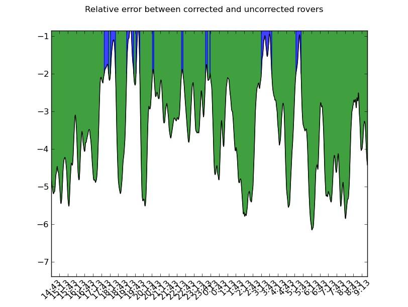
12 72 Hours on rooftop system
13 18 hours at Spring Valley

14 Vehicle Testing

15 Testing at UWA in Perth

16 Testing in a SkyWalker aircraft
17 Other low cost options SwiftNav 'Piksi' GPS around $500 per module built-in STM32 running RTK may be able to get decimeter accuracy for $1000 RTKLib open source GPS library implementing RTK combined with a RaspberryPi or BeagleBone may be able to get decimeter accuracy requires substantial CPU resources in aircraft
18 Conclusions It is possible to get better relative positioning using cheap DGPS and RTCMv2 injection Getting a good reference position is hard! New options such as Piksi will open up some new low cost options Altitude is still poor even with DGPS, so landing by GPS is still not a good option Code:
19
20
21
22
Introduction to GNSS Base-Station
 Introduction to GNSS Base-Station Dinesh Manandhar Center for Spatial Information Science The University of Tokyo Contact Information: dinesh@iis.u-tokyo.ac.jp Slide : 1 Introduction GPS or GNSS observation
GNSS Low-Cost High-Accuracy Receiver (L-CHAR)
") GNSS Low-Cost High-Accuracy Receiver (L-CHAR) Dinesh Manandhar Center for Spatial Information Science The University of Tokyo Contact Information: dinesh@iis.u-tokyo.ac.jp Slide : 1 High Accuracy Receivers
GNSS Low-Cost High-Accuracy Receiver (L-CHAR) Dinesh Manandhar Center for Spatial Information Science The University of Tokyo Contact Information: dinesh@iis.u-tokyo.ac.jp Slide : 1 High Accuracy Receivers
ION GNSS 2011 FILLING IN THE GAPS OF RTK WITH REGIONAL PPP
 ION GNSS 2011 FILLING IN THE GAPS OF RTK WITH REGIONAL PPP SEPTEMBER 22 th, 2011 ION GNSS 2011. PORTLAND, OREGON, USA SESSION F3: PRECISE POSITIONING AND RTK FOR CIVIL APPLICATION C. García A. Mozo P.
MGA Webinar Series : 1 Very Cheap RTK Receivers: Changing the Landscape of Positioning Services
 MGA Webinar Series : 1 Very Cheap RTK Receivers: Changing the Landscape of Positioning Services Dinesh Manandhar Center for Spatial Information Science The University of Tokyo Contact Information: dinesh@iis.u-tokyo.ac.jp
ENGI 3703 Surveying and Geomatics
 Satellite Geometry: Satellites well spread out in the sky have a much stronger solution to the resection type problem (aka trilateration) then satellite that are grouped together. Since the position of
Precise Point Positioning (PPP) using
 using") Precise Point Positioning (PPP) using Product Technical Notes // May 2009 OnPOZ is a product line of Effigis. EZSurv is a registered trademark of Effigis. All other trademarks are registered or recognized
Precise Point Positioning (PPP) using Product Technical Notes // May 2009 OnPOZ is a product line of Effigis. EZSurv is a registered trademark of Effigis. All other trademarks are registered or recognized
Precise Positioning with NovAtel CORRECT Including Performance Analysis
 Precise Positioning with NovAtel CORRECT Including Performance Analysis NovAtel White Paper April 2015 Overview This article provides an overview of the challenges and techniques of precise GNSS positioning.
High Precision GNSS in Automotive
 High Precision GNSS in Automotive Jonathan Auld, VP Engineering and Safety 6, March, 2018 2 Global OEM Positioning Solutions and Services for Land, Sea, and Air. GNSS in Automotive Today Today the primary
Guide to GNSS Base stations
 Guide to GNSS Base stations Outline Introduction Example of a base station (TUMSAT) Preparation for setting up a base station Procedure for setting up a base station Examples at two other universities
Evaluation of RTKLIB's Positioning Accuracy Using low-cost GNSS Receiver and ASG-EUPOS
 http://www.transnav.eu the International Journal on Marine Navigation and Safety of Sea Transportation Volume 7 Number 1 March 2013 DOI: 10.12716/1001.07.01.10 Evaluation of RTKLIB's Positioning Accuracy
Achieving 30 cm Autonomous Single Frequency GPS positioning
 Achieving 30 cm Autonomous Single Frequency GPS positioning Dr. Y. Zhang Nexteq Navigation Corporation 3535 Research Road NW Calgary, Alberta, Canada T2L 2K8 AGG 2009 www.nexteqnav.com 1 Outline Background
Global Correction Services for GNSS
 Global Correction Services for GNSS Hemisphere GNSS Whitepaper September 5, 2015 Overview Since the early days of GPS, new industries emerged while existing industries evolved to use position data in real-time.
Performance Evaluation of Differential Global Navigation Satellite System with RTK Corrections
 IOSR Journal of Electronics and Communication Engineering (IOSR-JECE) e-issn: 2278-2834,p- ISSN: 2278-8735.Volume 9, Issue 2, Ver. VI (Mar - Apr. 2014), PP 43-47 Performance Evaluation of Differential
Fast convergence of Trimble CenterPoint RTX by regional augmentation
 Fast convergence of Trimble CenterPoint RTX by regional augmentation Dr. Ralf Drescher Trimble Terrasat GmbH, Munich EGU General Assembly 2015, Vienna Thursday, 16 April 2015 Outline Introduction CenterPoint
The Global Positioning System
 The Global Positioning System 5-1 US GPS Facts of Note DoD navigation system First launch on 22 Feb 1978, fully operational in 1994 ~$15 billion (?) invested to date 24 (+/-) Earth-orbiting satellites
GPS Milestones, cont. GPS Milestones. The Global Positioning Sytem, Part 1 10/10/2017. M. Helper, GEO 327G/386G, UT Austin 1. US GPS Facts of Note
 The Global Positioning System US GPS Facts of Note DoD navigation system First launch on 22 Feb 1978, fully operational in 1994 ~$15 billion (?) invested to date 24 (+/-) Earth-orbiting satellites (SVs)
Reduction of Pseudorange Multipath Error in Static Positioning. Tokyo University of Mercantile Marine Nobuaki Kubo Akio Yasuda
 Reduction of Pseudorange Multipath Error in Static Positioning Tokyo University of Mercantile Marine Nobuaki Kubo Akio Yasuda Brief Many researchers have tried to reduce the multipath effect from both
DYNAMIC POSITIONING CONFERENCE
 DYNAMIC POSITIONING CONFERENCE Advances in DGPS Systems 28 September 2004 Ole Ørpen Fugro Seastar, Oslo, Norway SCOPE OF PRESENTATION -Background. -Carrier Phase Based Solutions. -Orbit/Clock Solutions.
The Benefits of Three Frequencies for the High Accuracy Positioning
 The Benefits of Three Frequencies for the High Accuracy Positioning Nobuaki Kubo (Tokyo University of Marine and Science Technology) Akio Yasuda (Tokyo University of Marine and Science Technology) Isao
MARINE TECHNOLOGY SOCIETY. DYNAMIC POSITIONING CONFERENCE, HOUSTON September 28-30, Advances in DGPS Systems
 Author s Name Name of the Paper Session MARINE TECHNOLOGY SOCIETY DYNAMIC POSITIONING CONFERENCE, HOUSTON September 28-30, 2004 Sensors Advances in DGPS Systems Ole Ørpen Fugro Seastar AS (Oslo, Norway)
Technical Specifications Document. for. Satellite-Based Augmentation System (SBAS) Testbed
 Testbed") Technical Specifications Document for Satellite-Based Augmentation System (SBAS) Testbed Revision 3 13 June 2017 Table of Contents Acronym Definitions... 3 1. Introduction... 4 2. SBAS Testbed Realisation...
Technical Specifications Document for Satellite-Based Augmentation System (SBAS) Testbed Revision 3 13 June 2017 Table of Contents Acronym Definitions... 3 1. Introduction... 4 2. SBAS Testbed Realisation...
SUPPORT OF NETWORK FORMATS BY TRIMBLE GPSNET NETWORK RTK SOLUTION
 SUPPORT OF NETWORK FORMATS BY TRIMBLE GPSNET NETWORK RTK SOLUTION TRIMBLE TERRASAT GMBH, HARINGSTRASSE 19, 85635 HOEHENKIRCHEN, GERMANY STATUS The Trimble GPSNet network RTK solution was first introduced
Positioning Australia for its farming future
 Positioning Australia for its farming future Utilizing the Japanese satellite navigation QZSS system to provide centimetre positioning accuracy across ALL Australia David Lamb 1,2 and Phil Collier 2 1
Scientific Journal of Silesian University of Technology. Series Transport Zeszyty Naukowe Politechniki Śląskiej. Seria Transport
 Scientific Journal of Silesian University of Technology. Series Transport Zeszyty Naukowe Politechniki Śląskiej. Seria Transport Volume 89 2015 p-issn: 0209-3324 e-issn: 2450-1549 DOI: Journal homepage:
Trimble GNSS Infrastructure
 Trimble GNSS Infrastructure A History of Innovation Trimble, the first company to offer commercial GPS products company to integrate GPS with communications technology RTK system in the market in 1994
Compact multi-gnss PPP corrections messages for transmission through a 250 bps channel
 Compact multi-gnss PPP corrections messages for transmission through a 250 bps channel Ken Harima, School of Science, RMIT University Suelynn Choy, School of Science, RMIT University Chris Rizos, School
Quasi-Zenith Satellite System (QZSS)
") Transmission of Augmentation Corrections using the Japanese QZSS for Real-Time Precise Point Positioning in Australia Ken Harima 1, Suelynn Choy 1, Mazher Choudhury 2, Chris Rizos 2, Satoshi Kogure 3 1
Transmission of Augmentation Corrections using the Japanese QZSS for Real-Time Precise Point Positioning in Australia Ken Harima 1, Suelynn Choy 1, Mazher Choudhury 2, Chris Rizos 2, Satoshi Kogure 3 1
GPS and Recent Alternatives for Localisation. Dr. Thierry Peynot Australian Centre for Field Robotics The University of Sydney
 GPS and Recent Alternatives for Localisation Dr. Thierry Peynot Australian Centre for Field Robotics The University of Sydney Global Positioning System (GPS) All-weather and continuous signal system designed
Comparative analysis of GNSS Real Time Kinematic methods for navigation
 IAV Hassan II Comparative analysis of GNSS Real Time Kinematic methods for navigation Mourad BOUZIANI School of Geomatic Sciences, IAV Hassan II, Rabat, Morocco. Coordinator of the Master - GNSS, IAV&
One Source for Positioning Success
 novatel.com One Source for Positioning Success RTK, PPP, SBAS OR DGNSS. NOVATEL CORRECT OPTIMIZES ALL CORRECTION SOURCES, PUTTING MORE POWER, FLEXIBILITY AND CONTROL IN YOUR HANDS. NovAtel CORRECT is the
METIS Second Master Training & Seminar. Augmentation Systems Available in Egypt
 METIS Second Master Training & Seminar Augmentation Systems Available in Egypt By Eng. Ramadan Salem M. Sc. Surveying and Geodesy Email: ramadan_salem@link.net Page 1 Augmentation Systems Available in
UNIT 1 - introduction to GPS
 UNIT 1 - introduction to GPS 1. GPS SIGNAL Each GPS satellite transmit two signal for positioning purposes: L1 signal (carrier frequency of 1,575.42 MHz). Modulated onto the L1 carrier are two pseudorandom
Global Positioning Systems (GPS) Trails: the achilles heel of mapping from the air / satellites
 Trails: the achilles heel of mapping from the air / satellites") Global Positioning Systems (GPS) Trails: the achilles heel of mapping from the air / satellites Google maps updated regularly by local users using GPS Also: http://openstreetmaps.org GPS applications
Global Positioning Systems (GPS) Trails: the achilles heel of mapping from the air / satellites Google maps updated regularly by local users using GPS Also: http://openstreetmaps.org GPS applications
Tersus RTK Competitive Analysis
 Test Report Jun 2018 Tersus RTK Competitive Analysis 2018 Tersus GNSS Inc. All rights reserved. Sales & Technical Support: sales@tersus-gnss.com & support@tersus-gnss.com More details, please visit www.tersus-gnss.com
FieldGenius Technical Notes GPS Terminology
 FieldGenius Technical Notes GPS Terminology Almanac A set of Keplerian orbital parameters which allow the satellite positions to be predicted into the future. Ambiguity An integer value of the number of
Real Time Kinematic GPS for Micro Aerial Vehicles
 Autonomous Systems Lab Prof. Roland Siegwart Semester-Thesis Real Time Kinematic GPS for Micro Aerial Vehicles Spring Term 212 Supervised by: Markus Achtelik Simon Lynen Author: Daniel Grieneisen Declaration
Global Navigation Satellite Systems II
 Global Navigation Satellite Systems II AERO4701 Space Engineering 3 Week 4 Last Week Examined the problem of satellite coverage and constellation design Looked at the GPS satellite constellation Overview
Effect of Quasi Zenith Satellite (QZS) on GPS Positioning
 on GPS Positioning") Effect of Quasi Zenith Satellite (QZS) on GPS ing Tomoji Takasu 1, Takuji Ebinuma 2, and Akio Yasuda 3 Laboratory of Satellite Navigation, Tokyo University of Marine Science and Technology 1 (Tel: +81-5245-7365,
Effect of Quasi Zenith Satellite (QZS) on GPS ing Tomoji Takasu 1, Takuji Ebinuma 2, and Akio Yasuda 3 Laboratory of Satellite Navigation, Tokyo University of Marine Science and Technology 1 (Tel: +81-5245-7365,
EXPERIMENTAL RESULTS OF LEX CORRECTIONS USING FARMING MACHINE
 Sixth Meeting of the International Committee on Global Navigation Satellite Systems (ICG) EXPERIMENTAL RESULTS OF LEX CORRECTIONS USING FARMING MACHINE Masayuki Kanzaki Hitachi Zosen Corporation Prof.
Receiver Technology CRESCENT OEM WHITE PAPER AMY DEWIS JENNIFER COLPITTS
 CRESCENT OEM WHITE PAPER AMY DEWIS JENNIFER COLPITTS With offices in Kansas City, Hiawatha, Calgary and Scottsdale, Hemisphere GPS is a global leader in designing and manufacturing innovative, costeffective,
GE 113 REMOTE SENSING
 GE 113 REMOTE SENSING Topic 9. Introduction to Global Positioning Systems (GPS) and Other GNSS Technologies Lecturer: Engr. Jojene R. Santillan jrsantillan@carsu.edu.ph Division of Geodetic Engineering
Study and analysis of Differential GNSS and Precise Point Positioning
 IOSR Journal of Electrical and Electronics Engineering (IOSR-JEEE) e-issn: 2278-1676,p-ISSN: 2320-3331, Volume 9, Issue 2 Ver. I (Mar Apr. 2014), PP 53-59 Study and analysis of Differential GNSS and Precise
GPS: The Basics. Darrell R. Dean, Jr. Civil and Environmental Engineering West Virginia University. Expected Learning Outcomes for GPS
 GPS: The Basics Darrell R. Dean, Jr. Civil and Environmental Engineering West Virginia University Expected Learning Outcomes for GPS Explain the acronym GPS Name 3 important tdt dates in history of GPS
Low-Cost GNSS for Geodetic Applications
 Institut für Ingenieurgeodäsie Presented at the FIG Congress 2018, May 6-11, 2018 in Istanbul, Turkey Low-Cost GNSS for Geodetic Applications Dr.-Ing. Li Zhang Institute of Engineering Geodesy (IIGS),
SSR Technology for Scalable Real-Time GNSS Applications
 SSR Technology for Scalable Real-Time GNSS Applications Gerhard Wübbena, Jannes Wübbena, Temmo Wübbena, Martin Schmitz Geo++ GmbH 30827 Garbsen, Germany www.geopp.de Abstract SSR Technology for scalable
gogps a navigation software to enhance the accuracy of low-cost GPS receivers Eugenio Realini Mirko Reguzzoni Osaka City University, Japan
 gogps a navigation software to enhance the accuracy of low-cost GPS receivers Eugenio Realini Osaka City University, Japan Oct. 21st FOSS4G2009 Mirko Reguzzoni OGS c/o Politecnico di Milano, Italy Why
DYNAMIC POSITIONING CONFERENCE October 7-8, Sensors II. Redundancy in Dynamic Positioning Systems Based on Satellite Navigation
 Return to Session Directory DYNAMIC POSITIONING CONFERENCE October 7-8, 2008 Sensors II Redundancy in Dynamic Positioning Systems Based on Satellite Navigation Ole Ørpen, Tor Egil Melgård, Arne Norum Fugro
Utilizing A GNSS Network Solution for Utility Applications
 Utilizing A GNSS Network Solution for Utility Applications David Newcomer, PE, PLS GPServ, Inc. newcomer@ (407) 601-5816 AGENDA Types and accuracies of data collection o Autonomous o Meter + o Sub-meter
Performance Evaluation Of Real Time Precise Point Positioning (RT-PPP) In Static & Kinematic Modes In Egypt
 In Static & Kinematic Modes In Egypt") Performance Evaluation Of Real Time Precise Point Positioning (RT-PPP) In Static & Kinematic Modes In Egypt Eng. Ahmed Mansour Abdallah Dr. Mahmoud Abd Rabbou Prof. Adel El.shazly Geomatic Branch, Civil
Performance Evaluation Of Real Time Precise Point Positioning (RT-PPP) In Static & Kinematic Modes In Egypt Eng. Ahmed Mansour Abdallah Dr. Mahmoud Abd Rabbou Prof. Adel El.shazly Geomatic Branch, Civil
NTRIP Background History, Development & BKG. Networked Transport of RTCM via Internet Protocol
 Networked Transport of RTCM via Internet Protocol Networked Transport of RTCM via Internet Protocol Bundesamt für Kartographie und Geodäsie Motivation: Use Internet to transport GNSS corrections Communication
Differential GPS Positioning over Internet
 Abstract Differential GPS Positioning over Internet Y. GAO AND Z. LIU Department of Geomatics Engineering The University of Calgary 2500 University Drive N.W. Calgary, Alberta, Canada T2N 1N4 Email: gao@geomatics.ucalgary.ca
Multipath and Atmospheric Propagation Errors in Offshore Aviation DGPS Positioning
 Multipath and Atmospheric Propagation Errors in Offshore Aviation DGPS Positioning J. Paul Collins, Peter J. Stewart and Richard B. Langley 2nd Workshop on Offshore Aviation Research Centre for Cold Ocean
GNSS & Coordinate Systems
 GNSS & Coordinate Systems Matthew McAdam, Marcelo Santos University of New Brunswick, Department of Geodesy and Geomatics Engineering, Fredericton, NB May 29, 2012 Santos, 2004 msantos@unb.ca 1 GNSS GNSS
PRINCIPLES AND FUNCTIONING OF GPS/ DGPS /ETS ER A. K. ATABUDHI, ORSAC
 PRINCIPLES AND FUNCTIONING OF GPS/ DGPS /ETS ER A. K. ATABUDHI, ORSAC GPS GPS, which stands for Global Positioning System, is the only system today able to show you your exact position on the Earth anytime,
Accuracy assessment of free web-based online GPS Processing services and relative GPS solution software
 82 Accuracy assessment of free web-based online GPS Processing services and relative GPS solution software Khaled Mahmoud Abdel Aziz Department of Surveying Engineering, Shoubra Faculty of Engineering,
Multisystem Real Time Precise-Point-Positioning, today with GPS+GLONASS in the near future also with QZSS, Galileo, Compass, IRNSS
 2 International Symposium on /GNSS October 26-28, 2. Multisystem Real Time Precise-Point-Positioning, today with +GLONASS in the near future also with QZSS, Galileo, Compass, IRNSS Álvaro Mozo García,
GPS Errors. Figure 1. Four satellites are required to determine a GPS position.
 Expl ai ni nggps:thegl obalposi t i oni ngsyst em since a minimum of four satellites is required to calculate a position (Fig 1). However, many newer GPS receivers are equipped to receive up to 12 satellite
The Global Positioning System II Field Experiments
 The Global Positioning System II Field Experiments 5-1 Mexico DGPS Field Campaign Cenotes in Tamaulipas, MX, near Aldama 5-2 Are Cenote Water Levels Related? 5-3 DGPS Static Survey of Cenote Water Levels
GAVIN DOCHERTY & CRAIG ROBERTS School of Surveying & Spatial Information Systems. University of NSW
 FIG2010, Sydney, Australia 15 April 2010 The impact of Solar Cycle 24 on Network RTK in Australia GAVIN DOCHERTY & CRAIG ROBERTS School of Surveying & Spatial Information Systems University of NSW School
GEO 428: DEMs from GPS, Imagery, & Lidar Tuesday, September 11
 GEO 428: DEMs from GPS, Imagery, & Lidar Tuesday, September 11 Global Positioning Systems GPS is a technology that provides Location coordinates Elevation For any location with a decent view of the sky
Precise Surveying with L1 RTK
 International Global Navigation Satellite Systems Society IGNSS Symposium 2007 The University of New South Wales, Sydney, Australia 4 6 December, 2007 Precise Surveying with L1 RTK Ian Iredale Mapsoft
The Wide Area Augmentation System
 The Wide Area Augmentation System Stanford University http://waas.stanford.edu What is Augmentation? 2 Add to GNSS to Enhance Service Improve integrity via real time monitoring Improve availability and
Experiences with Fugro's Real Time GPS/GLONASS Orbit/Clock Decimeter Level Precise Positioning System
 Return to Session Directory DYNAMIC POSITIONING CONFERENCE October 13-14, 2009 Sensors Experiences with Fugro's Real Time GPS/GLONASS Orbit/Clock Decimeter Level Precise Positioning System Ole Ørpen and
Fugro Marinestar Improvements
 Fugro Marinestar Improvements Hans Visser Fugro Intersite B.V. Improvements in Marinestar Positioning Hydro 2016 Warnemünde, 10 November 2016 Overview of presentation The Marinestar GNSS Networks The supplied
The Global Positioning Sytem II 10/19/2017
 The Global Positioning System II Field Experiments 10/19/2017 5-1 Mexico DGPS Field Campaign Cenotes in Tamaulipas, MX, near Aldama 10/19/2017 5-2 Are Cenote Water Levels Related? 10/19/2017 5-3 M. Helper,
Integer Ambiguity Resolution for Precise Point Positioning Patrick Henkel
 Integer Ambiguity Resolution for Precise Point Positioning Patrick Henkel Overview Introduction Sequential Best-Integer Equivariant Estimation Multi-frequency code carrier linear combinations Galileo:
ProMark 3 RTK. White Paper
 ProMark 3 RTK White Paper Table of Contents 1. Introduction... 1 2. ProMark3 RTK Operational Environment... 2 3. BLADE TM : A Unique Magellan Technology for Quicker Convergence... 3 4. ProMark3 RTK Fixed
SATELLITE BASED AUGMENTATION SYSTEM (SBAS) FOR AUSTRALIA
 FOR AUSTRALIA") SATELLITE BASED AUGMENTATION SYSTEM (SBAS) FOR AUSTRALIA AN AIN POSITION PAPER SUBMITTED TO VARIOUS GOVERNMENT DEPARTMENTS BY MR KYM OSLEY AM, CSC, EXEC SECRETARY AIN What are GNSS Augmentation Systems?
SATELLITE BASED AUGMENTATION SYSTEM (SBAS) FOR AUSTRALIA AN AIN POSITION PAPER SUBMITTED TO VARIOUS GOVERNMENT DEPARTMENTS BY MR KYM OSLEY AM, CSC, EXEC SECRETARY AIN What are GNSS Augmentation Systems?
Precise Positioning with Smartphones running Android 7 or later
 Precise Positioning with Smartphones running Android 7 or later * René Warnant, * Cécile Deprez, + Quentin Warnant * University of Liege Geodesy and GNSS + Augmenteo, Plaine Image, Lille (France) Belgian
Precise GNSS Positioning for Mass-market Applications
 Precise GNSS Positioning for Mass-market Applications Yang GAO, Canada Key words: GNSS, Precise GNSS Positioning, Precise Point Positioning (PPP), Correction Service, Low-Cost GNSS, Mass-Market Application
QZSS and LEX Signal. Performance of Real-Time Precise Point Positioning Using MADOCA-LEX Augmentation Messages. Outline
 Performance of Real-Time Precise Point Positioning Using MADOCA-LEX Augmentation Messages Suelynn Choy 1, Ken Harima 1, Mohammad Choudhury 2, Yong Li 2, Yaka Wakabayashi 3, Thomas Grinter 4, Satoshi Kogure
Performance Evaluation of the Effect of QZS (Quasi-zenith Satellite) on Precise Positioning
 on Precise Positioning") Performance Evaluation of the Effect of QZS (Quasi-zenith Satellite) on Precise Positioning Nobuaki Kubo, Tomoko Shirai, Tomoji Takasu, Akio Yasuda (TUMST) Satoshi Kogure (JAXA) Abstract The quasi-zenith
Performance Evaluation of the Effect of QZS (Quasi-zenith Satellite) on Precise Positioning Nobuaki Kubo, Tomoko Shirai, Tomoji Takasu, Akio Yasuda (TUMST) Satoshi Kogure (JAXA) Abstract The quasi-zenith
The topic we are going to see in this unit, the global positioning system, is not directly related with the computer networks we use everyday, but it
 The topic we are going to see in this unit, the global positioning system, is not directly related with the computer networks we use everyday, but it is indeed a kind of computer network, as the specialised
Procedures for Quality Control of GNSS Surveying Results Based on Network RTK Corrections.
 Procedures for Quality Control of GNSS Surveying Results Based on Network RTK Corrections. Limin WU, China Feng xia LI, China Joël VAN CRANENBROECK, Switzerland Key words : GNSS Rover RTK operations, GNSS
What is a GPS How does GPS work? GPS Segments GPS P osition Position Position Accuracy Accuracy Accuracy GPS A pplications Applications Applications
 What is GPS? What is a GPS How does GPS work? GPS Segments GPS Position Accuracy GPS Applications What is GPS? The Global Positioning System (GPS) is a precise worldwide radio-navigation system, and consists
Space Weather influence on satellite based navigation and precise positioning
 Space Weather influence on satellite based navigation and precise positioning R. Warnant, S. Lejeune, M. Bavier Royal Observatory of Belgium Avenue Circulaire, 3 B-1180 Brussels (Belgium) What this talk
GPS Tutorial Trimble Home > GPS Tutorial > How GPS works? > Triangulating
 http://www.trimble.com/gps/howgps-triangulating.shtml Page 1 of 3 Trimble Worldwide Popula PRODUCTS & SOLUTIONS SUPPORT & TRAINING ABOUT TRIMBLE INVESTORS GPS Tutorial Trimble Home > GPS Tutorial > How
NYSNET 11/28/2014 GPS/GLONASS (GG) January 2015 NYSAPLS Conference
 January 2015 NYSAPLS Conference") GPS/GLONASS (GG) January 2015 NYSAPLS Conference 2015 1 NYSNet 2015 GLONASS Upgrades Antenna Types Single Base/Network RTK GPS/GLONASS (GG) Single Base GPS/GLONASS (GG) Network RTK RT Products (NTRIP Mount
GPS/GLONASS (GG) January 2015 NYSAPLS Conference 2015 1 NYSNet 2015 GLONASS Upgrades Antenna Types Single Base/Network RTK GPS/GLONASS (GG) Single Base GPS/GLONASS (GG) Network RTK RT Products (NTRIP Mount
Real-Time Data Flow and Product Generation for GNSS. Jet Propulsion Laboratory. California Institute of Technology. Natural Resources Canada
 Real-Time Data Flow and Product Generation for GNSS Ronald J. Muellerschoen rjm @ mailhost4.jpl.nasa.gov Abstract Jet Propulsion Laboratory California Institute of Technology Mark Caissy caissy @NRCan.gc.ca
UNITED NATIONS UNIVERSITY Institute for Environment & Human Security (UNU-EHS) Bonn, Germany
 Bonn, Germany") UNITED NATIONS UNIVERSITY Institute for Environment & Human Security (UNU-EHS) Bonn, Germany Introduction to GPS technology Prof. Dr. Jörg Szarzynski Education Programme Director Head of Section EduSphere
UNITED NATIONS UNIVERSITY Institute for Environment & Human Security (UNU-EHS) Bonn, Germany Introduction to GPS technology Prof. Dr. Jörg Szarzynski Education Programme Director Head of Section EduSphere
Ultra-wideband Radio Aided Carrier Phase Ambiguity Resolution in Real-Time Kinematic GPS Relative Positioning. Eric Broshears
 Ultra-wideband Radio Aided Carrier Phase Ambiguity Resolution in Real-Time Kinematic GPS Relative Positioning by Eric Broshears AthesissubmittedtotheGraduateFacultyof Auburn University in partial fulfillment
Skytraq Manual (Single frequency receiver) Procedure to logging skytraq data with RTKNAVI
 Procedure to logging skytraq data with RTKNAVI") Tokyo University of Marine Science and Technology Skytraq Manual (Single frequency receiver) Procedure to logging skytraq data with RTKNAVI TUMSAT 1 Skytraq Receiver http://www.skytraq.com.tw/products/products.html
Tokyo University of Marine Science and Technology Skytraq Manual (Single frequency receiver) Procedure to logging skytraq data with RTKNAVI TUMSAT 1 Skytraq Receiver http://www.skytraq.com.tw/products/products.html
Advances in GNSS Technology and it s Application to Tidal Derivation
 Advances in GNSS Technology and it s Application to Tidal Derivation Tim Painter Chief Surveyor Fugro Survey Africa Pty Ltd John Vint Survey and Starfix Product Manager Fugro Survey AS, Norway Scope of
NR402 GIS Applications in Natural Resources
 NR402 GIS Applications in Natural Resources Lesson 5 GPS/GIS integration Global Positioning System (GPS)..a global navigation system that everyone can use What is GPS? How does it work? How accurate is
Global Navigation Satellite Systems (GNSS)Part I EE 570: Location and Navigation
Part I EE 570: Location and Navigation") Lecture Global Navigation Satellite Systems (GNSS)Part I EE 570: Location and Navigation Lecture Notes Update on April 25, 2016 Aly El-Osery and Kevin Wedeward, Electrical Engineering Dept., New Mexico
Lecture Global Navigation Satellite Systems (GNSS)Part I EE 570: Location and Navigation Lecture Notes Update on April 25, 2016 Aly El-Osery and Kevin Wedeward, Electrical Engineering Dept., New Mexico
Integration of GPS with a Rubidium Clock and a Barometer for Land Vehicle Navigation
 Integration of GPS with a Rubidium Clock and a Barometer for Land Vehicle Navigation Zhaonian Zhang, Department of Geomatics Engineering, The University of Calgary BIOGRAPHY Zhaonian Zhang is a MSc student
Resection. We can measure direction in the real world! Lecture 10: Position Determination. Resection Example: Isola, Slovenia. Professor Keith Clarke
 Geography 12: Maps and Spatial Reasoning Lecture 10: Position Determination We can measure direction in the real world! Professor Keith Clarke Resection Resection Example: Isola, Slovenia Back azimuth
Assessment of the Accuracy of Processing GPS Static Baselines Up To 40 Km Using Single and Dual Frequency GPS Receivers.
 International OPEN ACCESS Journal Of Modern Engineering Research (IJMER) Assessment of the Accuracy of Processing GPS Static Baselines Up To 40 Km Using Single and Dual Frequency GPS Receivers. Khaled
Real-Time and Multi-GNSS Key Projects of the International GNSS Service
 Real-Time and Multi-GNSS Key Projects of the International GNSS Service Urs Hugentobler, Chris Rizos, Mark Caissy, Georg Weber, Oliver Montenbruck, Ruth Neilan EUREF 2013 Symposium Budapest, Hungary, May
New Approach for Tsunami Detection Based on RTK-GNSS Using Network of Ships
 New Approach for Tsunami Detection Based on RTK-GNSS Using Network of Ships Tokyo University of Marine Science and Technology Ryuta Nakaosone Nobuaki Kubo Background After the Indian Ocean Tsunami on 2004,
Introduction to the Global Positioning System
 GPS for Fire Management - 2004 Introduction to the Global Positioning System Pre-Work Pre-Work Objectives Describe at least three sources of GPS signal error, and identify ways to mitigate or reduce those
Foreword by Glen Gibbons About this book Acknowledgments List of abbreviations and acronyms List of definitions
 Table of Foreword by Glen Gibbons About this book Acknowledgments List of abbreviations and acronyms List of definitions page xiii xix xx xxi xxv Part I GNSS: orbits, signals, and methods 1 GNSS ground
Positioning Techniques. João F. Galera Monico - UNESP Tuesday 12 Sep
 Positioning Techniques João F. Galera Monico - UNESP Tuesday 12 Sep Positioning methods Absolute Positioning Static and kinematic SPP and PPP Relative Positioning Static Static rapid Semi kinematic Kinematic
GPS Correction Comparisons RTK vs DGPS
 GPS Correction Comparisons RTK vs DGPS BULLETIN Abstract The position reported by a GPS receiver is not absolute. Many errors are introduced to the signal from the satellite. Satellite clock errors, propagation
Ultra-wideband Radio Aided Carrier Phase Ambiguity Resolution in Real-Time Kinematic GPS Relative Positioning
 Ultra-wideband Radio Aided Carrier Phase Ambiguity Resolution in Real-Time Kinematic GPS Relative Positioning Eric Broshears, Scott Martin and Dr. David Bevly, Auburn University Biography Eric Broshears
RTCM State Space Representation (SSR) Overall Concepts Towards PPP-RTK
 Overall Concepts Towards PPP-RTK") RTCM State Space Representation (SSR) Overall Concepts Towards PPP-RTK Gerhard Wübbena Geo++ GmbH 30827 Garbsen Germany www.geopp.de Contents Terms and Abbreviations RTCM-SSR Working Group GNSS Error Sources
RTCM State Space Representation (SSR) Overall Concepts Towards PPP-RTK Gerhard Wübbena Geo++ GmbH 30827 Garbsen Germany www.geopp.de Contents Terms and Abbreviations RTCM-SSR Working Group GNSS Error Sources
Asia Oceania Regional Workshop on GNSS Precise Point Positioning Experiment by using QZSS LEX
 Asia Oceania Regional Workshop on GNSS 2010 Precise Point Positioning Experiment by using QZSS LEX Tomoji TAKASU Tokyo University of Marine Science and Technology Contents Introduction of QZSS LEX Evaluation
Using GNSS for Robot Positioning
 Using GNSS fr Rbt Psitining Nam Nguyen DEC 2014 Hamburg University. Using GNSS fr Rbt Psitining - Nam Nguyen DEC 2014 1 Intrductin. GNSS GPS, GLONASS, GALILEO OUTLINE Traditinal techniques revisit (prs
The Reasons to Succeed or to Fail a GNSS Network RTK Project
 The Reasons to Succeed or to Fail a GNSS Network RTK Project Joël van Cranenbroeck, Managing Director CGEOS Creative Geosensing sprl-s, Belgium Andy Yin, International Sales Director ComNav Technology
FieldGenius Technical Notes GPS Differential Corrections
 FieldGenius Technical tes GPS Differential Corrections Introduction The accuracy requirement of survey grade or mapping grade GPS applications for real time positioning requires the use of differential