Advances in GNSS Technology and it s Application to Tidal Derivation
|
|
|
- Alvin Tucker
- 5 years ago
- Views:
Transcription


1
2 Advances in GNSS Technology and it s Application to Tidal Derivation Tim Painter Chief Surveyor Fugro Survey Africa Pty Ltd John Vint Survey and Starfix Product Manager Fugro Survey AS, Norway
3 Scope of Presentation History of GNSS Positioning Latest Developments within GNSS (PPP-IAR) System Accuracies for Latest GNSS Systems Derivation of Tidal Data from GNSS Summary


4 Transit system first used High frequency DGPS service HP dual-frequency service Starfix positioning system Satellite based DGPS 4
 service G4")


5 XP precise point positioning (PPP) service G4 multi-constellation PPP service G2 GPS & GLONASS PPP service G2+ ambiguity-fixed PPP service 5

6 Latest GNSS Developments within Fugro

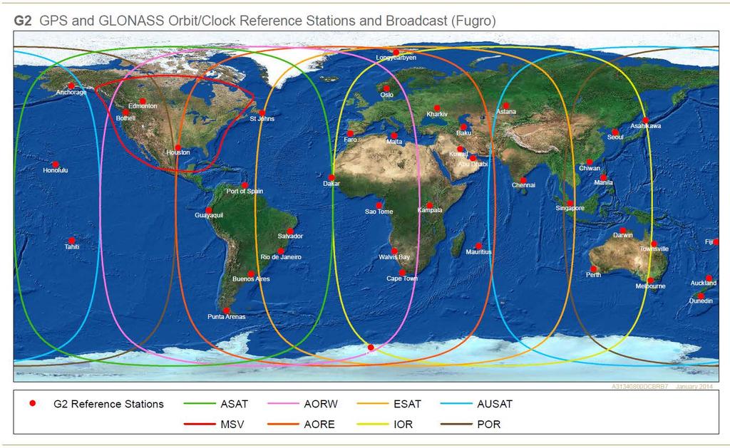
7 Starfix.G2 Dual frequency receiver GPS +GLONASS PPP position solution Fugro network of reference stations Accuracies are typically better than 10cm (95%) in horizontal and vertical
8

9 Starfix.G2 - DataFlow


10 Starfix.G4 Newest addition to Fugro positioning systems Precise point positioning (PPP) solution Orbit and clock corrections for GPS, GLONASS, Beidou and Galileo Galileo corrections available when Initial Operational Capability (IOC) announced by the European Union Improved availability and reliability
11 Starfix.G2+ Starfix.G2+ is a new service which improves the accuracy of the existing Starfix.G2 service. The Starfix.G2+ service uses a global network of reference stations to calculate an additional set of corrections that are sent to the user, which allows ambiguities to be fixed to an integer value.
, and therefore are lumped together as a real valued")
12 Standard PPP Precise point positioning (PPP) Dual frequency code and carrier phase measurements The precise satellite position and clock determined by network of reference stations and sent to the receiver Integer Ambiguity for the carrier phase measurements cannot be separated from the hardware biases (or uncalibrated phase delays -UPD), and therefore are lumped together as a real valued parameter Integer Ambiguity + HW bias = Float Solution
13 Standard PPP Approach Precise orbits and clocks GNSS measurements PPP engine Position

14 PPP with Integer Ambiguity Resolution (IAR) Satellite bias is common for all receivers in a network. Estimate satellite biases using reference station network and supply this to the user. Single differencing using a reference satellite removes receiver biases. Remaining estimated ambiguity has an integer nature. Attempt to fix to the correct integer value for cm-level accuracy. Ability to fix ambiguities to integer value is dependent on observation conditions.

15 PPP with IAR Map showing location of all reference stations used to calculate the UPD corrections
16 PPP-IAR Approach Precise orbits and clocks GNSS measurements Troposphere model PPP engine Hardware biases Ambiguities fixed? Yes No Ambiguity fixed position Ambiguity float position

17 Starfix.G2+ UPD Corrections The corrections the user should use are dependent on their geographic location. There are three regions with global coverage: 1. North and South America 2. Europe, Africa and Middle East 3. Asia and Australia Corrections generated for three large regions provide significantly better results compared to a single global set of corrections. The user does not need to be inside the region in order for the service to work, but should always choose the nearest region.


18 PPP-IAR Test Results StarPack receivers located at Fugro reference stations. Starfix.G2+ real-time orbit, clock and hardware bias corrections received through L-band link. Identical set-up as used in the field. 95% accuracy of 3.5 cm in horizontal and 8 cm in vertical achieved.
19 Test results: Bergen, Norway
20 Test results: Bergen, Norway
21 Test results: Great Yarmouth, United Kingdom
22 Test results: Great Yarmouth, United Kingdom
23 Test results: Houston, Tx, USA
24 Test results: Houston, TX, USA
25 Test results: Leidschendam, The Netherlands Interference
26 Test results: Leidschendam, The Netherlands Interference
27 Test results: Starfix.G2 vs Starfix.G2+ Values above the Starfix.G2+ bars show the percentage improvement compared to Starfix.G2
28 Test results: Global Comparison Global distribution of 101 sites Comparison between Starfix.G2 and Starfix.G2+ solutions Comparison of global sites for one day Comparison of one site over 8 days
29 Global test results: 7 October 2015, 101 sites
30 Test results: 8 days, Perth, Australia

31 Test results: 8 days, Istanbul, Turkey
32 Static results: 8 days, Romoland, CA, USA

33 Derivation of Tidal Data from GNSS Positioning Systems
34 GNSS Tides Computations 1 Height Observed GNSS antenna height above ellipsoid CRP height corrected for offset and roll, pitch and heading motion Water level above ellipsoid corrected for heave and draft and smoothing Calm Sea Waves 12 hours Ellipsoid Time
35 GNSS Tides Computations 2 Height Water level above ellipsoid MSS lookup value is subtracted The difference is the observed tide Calm Sea 12 hours Ellipsoid Time
36 GNSS Tides Main Components Dual Mode of Operation: Online real time tide computations and logging. Post-processing of logged real time data Multiple Calculations: Multiple MSS Models Available. Multiple Filters Available. Graphic Plots of Filter Performance. Real time NMEA telegram to customer software.
37 GNSS Tides Filters and Smoothing Filter Modes Raw Data, Real Time and Near Real Time. Filter Types: Spike Detection. Polynomial Fit. Moving Average. Savitzky-Golay Filter. Finite Impulse Filter (FIR). Doodson X0 Filter.

38 GNSS Tides Overview

39 GNSS Tides Filter Performance
40 Summary Fugro is the first company that has offered ambiguity-fixed PPP to the offshore market Our service has been developed throughout the research, development, implementation and testing phases specifically with the offshore market in mind Our results show that we can consistently achieve the stated accuracies of 3.5 cm horizontal and 8 cm vertical
Fugro Marinestar Improvements
 Fugro Marinestar Improvements Hans Visser Fugro Intersite B.V. Improvements in Marinestar Positioning Hydro 2016 Warnemünde, 10 November 2016 Overview of presentation The Marinestar GNSS Networks The supplied
Experiences with Fugro's Real Time GPS/GLONASS Orbit/Clock Decimeter Level Precise Positioning System
 Return to Session Directory DYNAMIC POSITIONING CONFERENCE October 13-14, 2009 Sensors Experiences with Fugro's Real Time GPS/GLONASS Orbit/Clock Decimeter Level Precise Positioning System Ole Ørpen and
Fugro Satellite Positioning. What we do PUBLIC. Rob Buttress Fugro Satellite Positioning AS.
 Fugro Satellite Positioning What we do Rob Buttress Fugro Satellite Positioning AS PUBLIC Fugro Satellite Positioning Who are we? Provider of GNSS augmentation signals to the offshore industry A business
Hydrofest The Hydrographic Society in Scotland
 Hydrofest 2017 The Hydrographic Society in Scotland POSITIONING SYSTEMS Eddie Milne 1. GNSS Positioning 2. Additional Sensors 3. Alternative Positioning 4. Bringing it altogether GNSS = GPS + Glonass +
Trimble Business Center:
 Trimble Business Center: Modernized Approaches for GNSS Baseline Processing Trimble s industry-leading software includes a new dedicated processor for static baselines. The software features dynamic selection
Precise Point Positioning with BeiDou
 Precise Point Positioning with BeiDou Ole Ørpen Fugro Satellite Positioning AS Geodesi- og Hydrografidagene Stavanger, 12-13 Nov. 2014 Fugro 2013 Contents The G2 service Galileo Testing 2013 BeiDou Testing
DYNAMIC POSITIONING CONFERENCE October 7-8, Sensors II. Redundancy in Dynamic Positioning Systems Based on Satellite Navigation
 Return to Session Directory DYNAMIC POSITIONING CONFERENCE October 7-8, 2008 Sensors II Redundancy in Dynamic Positioning Systems Based on Satellite Navigation Ole Ørpen, Tor Egil Melgård, Arne Norum Fugro
MARINE TECHNOLOGY SOCIETY. DYNAMIC POSITIONING CONFERENCE, HOUSTON September 28-30, Advances in DGPS Systems
 Author s Name Name of the Paper Session MARINE TECHNOLOGY SOCIETY DYNAMIC POSITIONING CONFERENCE, HOUSTON September 28-30, 2004 Sensors Advances in DGPS Systems Ole Ørpen Fugro Seastar AS (Oslo, Norway)
Fast convergence of Trimble CenterPoint RTX by regional augmentation
 Fast convergence of Trimble CenterPoint RTX by regional augmentation Dr. Ralf Drescher Trimble Terrasat GmbH, Munich EGU General Assembly 2015, Vienna Thursday, 16 April 2015 Outline Introduction CenterPoint
DYNAMIC POSITIONING CONFERENCE
 DYNAMIC POSITIONING CONFERENCE Advances in DGPS Systems 28 September 2004 Ole Ørpen Fugro Seastar, Oslo, Norway SCOPE OF PRESENTATION -Background. -Carrier Phase Based Solutions. -Orbit/Clock Solutions.
GPS for. Land Surveyors. Jan Van Sickle. Fourth Edition. CRC Press. Taylor & Francis Group. Taylor & Francis Croup, an Informa business
 GPS for Land Surveyors Fourth Edition Jan Van Sickle CRC Press Taylor & Francis Group Boca Raton London New York CRC Press is an imprint of the Taylor & Francis Croup, an Informa business Contents Preface
GPS-Aided INS Datasheet Rev. 2.3
 GPS-Aided INS 1 The Inertial Labs Single and Dual Antenna GPS-Aided Inertial Navigation System INS is new generation of fully-integrated, combined L1 & L2 GPS, GLONASS, GALILEO and BEIDOU navigation and
The Global Positioning System II Field Experiments
 The Global Positioning System II Field Experiments 5-1 Mexico DGPS Field Campaign Cenotes in Tamaulipas, MX, near Aldama 5-2 Are Cenote Water Levels Related? 5-3 DGPS Static Survey of Cenote Water Levels
One Source for Positioning Success
 novatel.com One Source for Positioning Success RTK, PPP, SBAS OR DGNSS. NOVATEL CORRECT OPTIMIZES ALL CORRECTION SOURCES, PUTTING MORE POWER, FLEXIBILITY AND CONTROL IN YOUR HANDS. NovAtel CORRECT is the
The Global Positioning Sytem II 10/19/2017
 The Global Positioning System II Field Experiments 10/19/2017 5-1 Mexico DGPS Field Campaign Cenotes in Tamaulipas, MX, near Aldama 10/19/2017 5-2 Are Cenote Water Levels Related? 10/19/2017 5-3 M. Helper,
GPS STATIC-PPP POSITIONING ACCURACY VARIATION WITH OBSERVATION RECORDING INTERVAL FOR HYDROGRAPHIC APPLICATIONS (ASWAN, EGYPT)
") GPS STATIC-PPP POSITIONING ACCURACY VARIATION WITH OBSERVATION RECORDING INTERVAL FOR HYDROGRAPHIC APPLICATIONS (ASWAN, EGYPT) Ashraf Farah Associate Professor,College of Engineering, Aswan University,
GPS STATIC-PPP POSITIONING ACCURACY VARIATION WITH OBSERVATION RECORDING INTERVAL FOR HYDROGRAPHIC APPLICATIONS (ASWAN, EGYPT) Ashraf Farah Associate Professor,College of Engineering, Aswan University,
ProMark 3 RTK. White Paper
 ProMark 3 RTK White Paper Table of Contents 1. Introduction... 1 2. ProMark3 RTK Operational Environment... 2 3. BLADE TM : A Unique Magellan Technology for Quicker Convergence... 3 4. ProMark3 RTK Fixed
Presented at the FIG Congress 2018, May 6-11, 2018 in Istanbul, Turkey
 Presented at the FIG Congress 2018, May 6-11, 2018 in Istanbul, Turkey 2 Improving Hydrographic PPP by Height Constraining Ashraf Abdallah (Egypt) Volker Schwieger, (Germany) ashraf.abdallah@aswu.edu.eg
Multi-Constellation GNSS Precise Point Positioning using GPS, GLONASS and BeiDou in Australia
 International Global Navigation Satellite Systems Society IGNSS Symposium 2015 Multi-Constellation GNSS Precise Point Positioning using GPS, GLONASS and BeiDou in Australia Xiaodong Ren 1,Suelynn Choy
Precise Positioning with NovAtel CORRECT Including Performance Analysis
 Precise Positioning with NovAtel CORRECT Including Performance Analysis NovAtel White Paper April 2015 Overview This article provides an overview of the challenges and techniques of precise GNSS positioning.
GPS-Aided INS Datasheet Rev. 2.6
 GPS-Aided INS 1 GPS-Aided INS The Inertial Labs Single and Dual Antenna GPS-Aided Inertial Navigation System INS is new generation of fully-integrated, combined GPS, GLONASS, GALILEO and BEIDOU navigation
Contributions of multi-gnss constellations to Precise Point Positioning (PPP) with raw measurements model
 with raw measurements model") Contributions of multi-gnss constellations to Precise Point Positioning (PPP) with raw measurements model Fu Zheng, Yidong Lou, Shengfeng Gu Charles Wang, Hailin Guo, Yanming Feng GNSS Centre, Wuhan University
Contributions of multi-gnss constellations to Precise Point Positioning (PPP) with raw measurements model Fu Zheng, Yidong Lou, Shengfeng Gu Charles Wang, Hailin Guo, Yanming Feng GNSS Centre, Wuhan University
Introduction to GNSS Base-Station
 Introduction to GNSS Base-Station Dinesh Manandhar Center for Spatial Information Science The University of Tokyo Contact Information: dinesh@iis.u-tokyo.ac.jp Slide : 1 Introduction GPS or GNSS observation
Inertial Navigation System
 Apogee Series ULTIMATE ACCURACY MEMS Inertial Navigation System INS MRU AHRS ITAR Free 0.005 RMS Motion Sensing & Georeferencing APOGEE SERIES makes high accuracy affordable for all surveying companies.
Bernhard Hofnlann-Wellenhof Herbert Lichtenegger Elmar Wasle. GNSS - Global Navigation Satellite Systenls. GPS, GLONASS, Galileo, and nl0re
 Bernhard Hofnlann-Wellenhof Herbert Lichtenegger Elmar Wasle GNSS - Global Navigation Satellite Systenls GPS, GLONASS, Galileo, and nl0re SpringerWienNewYork Contents Abbreviations xxi 1 Introduction 1
Precise Positioning GNSS Applications
 Precise Point Positioning: Is the Era of Differential GNSS Positioning Drawing to an End? School of Surveying & Spatial Information Systems, UNSW, Sydney, Australia Chris Rizos 1, Volker Janssen 2, Craig
GNSS & Coordinate Systems
 GNSS & Coordinate Systems Matthew McAdam, Marcelo Santos University of New Brunswick, Department of Geodesy and Geomatics Engineering, Fredericton, NB May 29, 2012 Santos, 2004 msantos@unb.ca 1 GNSS GNSS
International Journal of Scientific & Engineering Research, Volume 6, Issue 8, August ISSN
 International Journal of Scientific & Engineering Research, Volume 6, Issue 8, August-2015 683 Assessment Accuracy of Static Relative Positioning Using Single Frequency GPS Receivers Mahmoud I. El-Mewafi
ION ITM Tokyo University of Marine Science and Technology H. Sridhara, N. Kubo, R.Kikuchi
 Single-Frequency Multi-GNSS RTK Positioning for Moving Platform ION ITM 215 215.1.27-29 Tokyo University of Marine Science and Technology H. Sridhara, N. Kubo, R.Kikuchi 1 Agenda Motivation and Background
FieldGenius Technical Notes GPS Terminology
 FieldGenius Technical Notes GPS Terminology Almanac A set of Keplerian orbital parameters which allow the satellite positions to be predicted into the future. Ambiguity An integer value of the number of
Positioning with Single and Dual Frequency Smartphones Running Android 7 or Later
 Positioning with Single and Dual Frequency Smartphones Running Android 7 or Later * René Warnant, *Laura Van De Vyvere, + Quentin Warnant * University of Liege Geodesy and GNSS + Augmenteo, Plaine Image,
ION GNSS 2011 FILLING IN THE GAPS OF RTK WITH REGIONAL PPP
 ION GNSS 2011 FILLING IN THE GAPS OF RTK WITH REGIONAL PPP SEPTEMBER 22 th, 2011 ION GNSS 2011. PORTLAND, OREGON, USA SESSION F3: PRECISE POSITIONING AND RTK FOR CIVIL APPLICATION C. García A. Mozo P.
Quasi-Zenith Satellite System (QZSS)
") Transmission of Augmentation Corrections using the Japanese QZSS for Real-Time Precise Point Positioning in Australia Ken Harima 1, Suelynn Choy 1, Mazher Choudhury 2, Chris Rizos 2, Satoshi Kogure 3 1
Transmission of Augmentation Corrections using the Japanese QZSS for Real-Time Precise Point Positioning in Australia Ken Harima 1, Suelynn Choy 1, Mazher Choudhury 2, Chris Rizos 2, Satoshi Kogure 3 1
Precise Positioning with Smartphones running Android 7 or later
 Precise Positioning with Smartphones running Android 7 or later * René Warnant, * Cécile Deprez, + Quentin Warnant * University of Liege Geodesy and GNSS + Augmenteo, Plaine Image, Lille (France) Belgian
When do you expect Athena to be available for VS330? This is currently being beta-tested and will be released in the very near future.
 Why Athena? Athena GNSS Engine What improvements does Athena offer over the RTK firmware I m running now? Compared to the Hemisphere firmware most users are currently using (Qf4), there are significant
GNSS analysis software GSILIB for utilizing Multi- GNSS data
 Technical Seminar Reference Frame in Practice, GNSS analysis software GSILIB for utilizing Multi- GNSS data *Satoshi Kawamoto, Naofumi Takamatsu Geospatial Information Authority of Japan Sponsors: Geospatial
GNSS Low-Cost High-Accuracy Receiver (L-CHAR)
") GNSS Low-Cost High-Accuracy Receiver (L-CHAR) Dinesh Manandhar Center for Spatial Information Science The University of Tokyo Contact Information: dinesh@iis.u-tokyo.ac.jp Slide : 1 High Accuracy Receivers
GNSS Low-Cost High-Accuracy Receiver (L-CHAR) Dinesh Manandhar Center for Spatial Information Science The University of Tokyo Contact Information: dinesh@iis.u-tokyo.ac.jp Slide : 1 High Accuracy Receivers
Motion & Navigation Solution
 Navsight Land & Air Solution Motion & Navigation Solution FOR SURVEYING APPLICATIONS Motion, Navigation, and Geo-referencing NAVSIGHT LAND/AIR SOLUTION is a full high performance inertial navigation solution
Latest PPP Efforts at UNB ( )
") Latest PPP Efforts at UNB (2007-2008) Simon Banville Rodrigo F. Leandro Hyunho Rho Richard B. Langley Marcelo C. Santos May 27 2008 GEOIDE Annual Conference Niagara Falls, ON, Canada Outline Impact of
Latest PPP Efforts at UNB (2007-2008) Simon Banville Rodrigo F. Leandro Hyunho Rho Richard B. Langley Marcelo C. Santos May 27 2008 GEOIDE Annual Conference Niagara Falls, ON, Canada Outline Impact of
ORBITS AND CLOCKS FOR GLONASS PPP
 ION GNSS 2009 ORBITS AND CLOCKS FOR GLONASS PPP SEPTEMBER 22-25, 2009 - SAVANNAH, GEORGIA SESSION E3: PPP AND NETWORK-BASED RTK 1 D. Calle A. Mozo P. Navarro R. Píriz D. Rodríguez G. Tobías September 24,
Connecting a Cadastral Survey to PNG94 using GNSS
 43rd Association of Surveyors PNG Congress, Lae, 12th-15th August 2009 Connecting a Cadastral Survey to PNG94 using GNSS Richard Stanaway QUICKCLOSE Workshop overview Legal requirements to connect surveys
VARIATION OF STATIC-PPP POSITIONING ACCURACY USING GPS-SINGLE FREQUENCY OBSERVATIONS (ASWAN, EGYPT)
") ARTIFICIAL SATELLITES, Vol. 52, No. 2 2017 DOI: 10.1515/arsa-2017-0003 VARIATION OF STATIC-PPP POSITIONING ACCURACY USING GPS-SINGLE FREQUENCY OBSERVATIONS (ASWAN, EGYPT) Ashraf Farah Associate professor,
ARTIFICIAL SATELLITES, Vol. 52, No. 2 2017 DOI: 10.1515/arsa-2017-0003 VARIATION OF STATIC-PPP POSITIONING ACCURACY USING GPS-SINGLE FREQUENCY OBSERVATIONS (ASWAN, EGYPT) Ashraf Farah Associate professor,
GPS for crustal deformation studies. May 7, 2009
 GPS for crustal deformation studies May 7, 2009 High precision GPS for Geodesy Use precise orbit products (e.g., IGS or JPL) Use specialized modeling software GAMIT/GLOBK GIPSY OASIS BERNESE These software
Integer Ambiguity Resolution for Precise Point Positioning Patrick Henkel
 Integer Ambiguity Resolution for Precise Point Positioning Patrick Henkel Overview Introduction Sequential Best-Integer Equivariant Estimation Multi-frequency code carrier linear combinations Galileo:
GNSS 101 Bringing It Down To Earth
 GNSS 101 Bringing It Down To Earth Steve Richter Frontier Precision, Inc. UTM County Coordinates NGVD 29 State Plane Datums Scale Factors Projections Session Agenda GNSS History & Basic Theory Coordinate
Wednesday AM: (Doug) 2. PS and Long Period Signals
 2. PS and Long Period Signals") Wednesday AM: (Doug) 2 PS and Long Period Signals What is Colorado famous for? 32 satellites 12 Early on in the world of science synchronization of clocks was found to be important. consider Paris: puffs
Wednesday AM: (Doug) 2 PS and Long Period Signals What is Colorado famous for? 32 satellites 12 Early on in the world of science synchronization of clocks was found to be important. consider Paris: puffs
GPS-Aided INS Datasheet Rev. 3.0
 1 GPS-Aided INS The Inertial Labs Single and Dual Antenna GPS-Aided Inertial Navigation System INS is new generation of fully-integrated, combined GPS, GLONASS, GALILEO, QZSS, BEIDOU and L-Band navigation
New developments in offshore precise GNSS positioning
 New developments in offshore precise GNSS positioning Kees de Jong Fugro Intersite B.V. November 2013 Contents Profile Mission is to be the world s leading service-provider in the collection and interpretation
The Global Positioning System II Field Experiments. 10/10/2013 GEO327G/386G, UT Austin 5-1
 The Global Positioning System II Field Experiments 10/10/2013 GEO327G/386G, UT Austin 5-1 Mexico DGPS Field Campaign Cenotes in Tamaulipas, MX, near Aldama 10/10/2013 GEO327G/386G, UT Austin 5-2 Are Cenote
Performance Evaluation of Differential Global Navigation Satellite System with RTK Corrections
 IOSR Journal of Electronics and Communication Engineering (IOSR-JECE) e-issn: 2278-2834,p- ISSN: 2278-8735.Volume 9, Issue 2, Ver. VI (Mar - Apr. 2014), PP 43-47 Performance Evaluation of Differential
Analysis of GNSS Receiver Biases and Noise using Zero Baseline Techniques
 1 Analysis of GNSS Receiver Biases and Noise using Zero Baseline Techniques Ken MacLeod, Simon Banville, Reza Ghoddousi-Fard and Paul Collins Canadian Geodetic Survey, Natural Resources Canada Plenary
GPS-Aided INS Datasheet Rev. 2.7
 1 The Inertial Labs Single and Dual Antenna GPS-Aided Inertial Navigation System INS is new generation of fully-integrated, combined GPS, GLONASS, GALILEO, QZSS and BEIDOU navigation and highperformance
Principal Investigator Co-Principal Investigator Co-Principal Investigator Prof. Talat Ahmad Vice-Chancellor Jamia Millia Islamia Delhi
 Subject Paper No and Title Module No and Title Module Tag Geology Remote Sensing and GIS Concepts of Global Navigation Satellite RS & GIS XXXIII Principal Investigator Co-Principal Investigator Co-Principal
Prospect for Global Positioning Augmentation Service by QZSS
 Prospect for Global Positioning Augmentation Service by QZSS Global Positioning Augmentation Service Corporation Director, Yoshikatsu Iotake Feb. 6, 2018 Copyright 2018 Global Positioning Augmentation
Guochang Xu GPS. Theory, Algorithms and Applications. Second Edition. With 59 Figures. Sprin ger
 Guochang Xu GPS Theory, Algorithms and Applications Second Edition With 59 Figures Sprin ger Contents 1 Introduction 1 1.1 AKeyNoteofGPS 2 1.2 A Brief Message About GLONASS 3 1.3 Basic Information of Galileo
RTCM State Space Representation (SSR) Overall Concepts Towards PPP-RTK
 Overall Concepts Towards PPP-RTK") RTCM State Space Representation (SSR) Overall Concepts Towards PPP-RTK Gerhard Wübbena Geo++ GmbH 30827 Garbsen Germany www.geopp.de Contents Terms and Abbreviations RTCM-SSR Working Group GNSS Error Sources
RTCM State Space Representation (SSR) Overall Concepts Towards PPP-RTK Gerhard Wübbena Geo++ GmbH 30827 Garbsen Germany www.geopp.de Contents Terms and Abbreviations RTCM-SSR Working Group GNSS Error Sources
Connecting a Survey to PNG94 and MSL using GNSS
 45th Association of Surveyors PNG Congress, Madang, 19-22 July 2011 Connecting a Survey to PNG94 and MSL using GNSS Richard Stanaway QUICKCLOSE Workshop overview Legal requirements to connect surveys to
Surveying in the Year 2020
 Surveying in the Year 2020 Johannes Schwarz Leica Geosystems My first toys 2 1 3 Questions Why is a company like Leica Geosystems constantly developing new surveying products and instruments? What surveying
The Benefit of Triple Frequency on Cycle Slip Detection
 Presented at the FIG Congress 2018, The Benefit of Triple Frequency on Cycle Slip Detection May 6-11, 2018 in Istanbul, Turkey Dong Sheng Zhao 1, Craig Hancock 1, Gethin Roberts 2, Lawrence Lau 1 1 The
Multi-GNSS / Multi-Signal code bias determination from raw GNSS observations
 Multi-GNSS / Multi-Signal code bias determination from raw GNSS observations F. Reckeweg, E. Schönemann, T. Springer, M. Becker, W. Enderle Geodätische Woche 2016 InterGEO 11.-13. October 2016 Hamburg,
MGA Webinar Series : 1 Very Cheap RTK Receivers: Changing the Landscape of Positioning Services
 MGA Webinar Series : 1 Very Cheap RTK Receivers: Changing the Landscape of Positioning Services Dinesh Manandhar Center for Spatial Information Science The University of Tokyo Contact Information: dinesh@iis.u-tokyo.ac.jp
METIS Second Master Training & Seminar. Augmentation Systems Available in Egypt
 METIS Second Master Training & Seminar Augmentation Systems Available in Egypt By Eng. Ramadan Salem M. Sc. Surveying and Geodesy Email: ramadan_salem@link.net Page 1 Augmentation Systems Available in
Assessment of GNSS Ionospheric Scintillation and TEC Monitoring Using the Multi-constellation GPStation-6 Receiver
 Assessment of GNSS Ionospheric Scintillation and TEC Monitoring Using the Multi-constellation GPStation-6 Receiver Rod MacLeod Regional Manager Asia/Pacific NovAtel Australia Pty Ltd Outline Ionospheric
Evaluation of Multi-Constellation GNSS Precise Point Positioning (PPP) Techniques in Egypt
 Techniques in Egypt") Evaluation of Multi-Constellation GNSS Precise Point Positioning (PPP) Techniques in Egypt Mahmoud Abd Rabbou and Adel El-Shazly Department of Civil Engineering, Cairo University Presented by; Dr. Mahmoud
Evaluation of Multi-Constellation GNSS Precise Point Positioning (PPP) Techniques in Egypt Mahmoud Abd Rabbou and Adel El-Shazly Department of Civil Engineering, Cairo University Presented by; Dr. Mahmoud
Sub-daily signals in GPS. at semi-annual and annual periods
 Sub-daily signals in GPS observations and their effect at semi-annual and annual periods Matt King1 Chris Watson2, Nigel Penna1 Newcastle University, UK 2 University of Tasmania, Australia 1 Propagation
EXPERIMENTAL RESULTS OF LEX CORRECTIONS USING FARMING MACHINE
 Sixth Meeting of the International Committee on Global Navigation Satellite Systems (ICG) EXPERIMENTAL RESULTS OF LEX CORRECTIONS USING FARMING MACHINE Masayuki Kanzaki Hitachi Zosen Corporation Prof.
RTCM-SSR Strategy of Bias Treatment
 RTCM-SSR Strategy of Bias Treatment Gerhard Wübbena Geo++ GmbH 30827 Garbsen Germany www.geopp.de Chair of RTCM-SSR WG www.rtcm.org RTCM-SC104 SSR Development working group established in 2007 3 message
Introduction to Global Navigation Satellite System (GNSS) Signal Structure
 Signal Structure") Introduction to Global Navigation Satellite System (GNSS) Signal Structure Dinesh Manandhar Center for Spatial Information Science The University of Tokyo Contact Information: dinesh@iis.u-tokyo.ac.jp
Introduction to Global Navigation Satellite System (GNSS) Signal Structure Dinesh Manandhar Center for Spatial Information Science The University of Tokyo Contact Information: dinesh@iis.u-tokyo.ac.jp
The Benefits of Three Frequencies for the High Accuracy Positioning
 The Benefits of Three Frequencies for the High Accuracy Positioning Nobuaki Kubo (Tokyo University of Marine and Science Technology) Akio Yasuda (Tokyo University of Marine and Science Technology) Isao
GNSS Technologies. PPP and RTK
 PPP and RTK 29.02.2016 Content Carrier phase based positioning PPP RTK VRS Slides based on: GNSS Applications and Methods, by S. Gleason and D. Gebre-Egziabher (Eds.), Artech House Inc., 2009 http://www.gnssapplications.org/
Global Correction Services for GNSS
 Global Correction Services for GNSS Hemisphere GNSS Whitepaper September 5, 2015 Overview Since the early days of GPS, new industries emerged while existing industries evolved to use position data in real-time.
BeiDou Orbit Determination Processes and Products in JPL's GDGPS System
 BeiDou Orbit Determination Processes and Products in JPL's GDGPS System Ant Sibthorpe, Yoaz Bar-Sever, Willy Bertiger, Wenwen Lu, Robert Meyer, Mark Miller and Larry Romans Outline GNSS (GPS/BDS) with
hydro8 Precise Point Positioning, the new DGPS: The C-Nav Experience Edwin Danson FRICS FInstCES FRAS Business strategy consultant
 hydro8 Precise Point Positioning, the new DGPS: The C-Nav Experience Edwin Danson FRICS FInstCES FRAS Business strategy consultant C-Nav Worldwide Precise Point Positioning with In-built Autonomy for Assurance
SSR Technology for Scalable Real-Time GNSS Applications
 SSR Technology for Scalable Real-Time GNSS Applications Gerhard Wübbena, Jannes Wübbena, Temmo Wübbena, Martin Schmitz Geo++ GmbH 30827 Garbsen, Germany www.geopp.de Abstract SSR Technology for scalable
Understanding GPS: Principles and Applications Second Edition
 Understanding GPS: Principles and Applications Second Edition Elliott Kaplan and Christopher Hegarty ISBN 1-58053-894-0 Approx. 680 pages Navtech Part #1024 This thoroughly updated second edition of an
Global Navigation Satellite System for IE 5000
 Global Navigation Satellite System for IE 5000 Configuring GNSS 2 Information About GNSS 2 Guidelines and Limitations 4 Default Settings 4 Configuring GNSS 5 Configuring GNSS as Time Source for PTP 6 Verifying
Asian Journal of Science and Technology Vol. 08, Issue, 11, pp , November, 2017 RESEARCH ARTICLE
 Available Online at http://www.journalajst.com ASIAN JOURNAL OF SCIENCE AND TECHNOLOGY ISSN: 0976-3376 Asian Journal of Science and Technology Vol. 08, Issue, 11, pp.6697-6703, November, 2017 ARTICLE INFO
Beginners Guide to GPS Elevation Plus an Update on GPS Technology
 Beginners Guide to GPS Elevation Plus an Update on GPS Technology A TMS Presentation By: Jon Aschenbach Summerlake Enterprises 919 36 th Place Forest Grove, OR 97116 503-707-6236 Coeur d Alene, ID April,
Precise Point Positioning (PPP) using
 using") Precise Point Positioning (PPP) using Product Technical Notes // May 2009 OnPOZ is a product line of Effigis. EZSurv is a registered trademark of Effigis. All other trademarks are registered or recognized
Precise Point Positioning (PPP) using Product Technical Notes // May 2009 OnPOZ is a product line of Effigis. EZSurv is a registered trademark of Effigis. All other trademarks are registered or recognized
High Precision GNSS for Mapping & GIS Professionals
 High Precision GNSS for Mapping & GIS Professionals Agenda Address your needs for GNSS knowledge. GNSS Basics Satellite Ranging Fundamentals (Code $ Carrier) Differential Corrections (Post Processed $
Integrity of Satellite Navigation in the Arctic
 Integrity of Satellite Navigation in the Arctic TODD WALTER & TYLER REID STANFORD UNIVERSITY APRIL 2018 Satellite Based Augmentation Systems (SBAS) in 2018 2 SBAS Networks in 2021? 3 What is Meant by Integrity?
Applanix Products and Solutions for Hydrographic Survey & Marine Applications Maximize Your Productivity!
 Applanix Products and Solutions for Hydrographic Survey & Marine Applications Maximize Your Productivity! Applanix technology and support gives you the advantage: lower costs of deployment, faster times
GPS and Recent Alternatives for Localisation. Dr. Thierry Peynot Australian Centre for Field Robotics The University of Sydney
 GPS and Recent Alternatives for Localisation Dr. Thierry Peynot Australian Centre for Field Robotics The University of Sydney Global Positioning System (GPS) All-weather and continuous signal system designed
BDS Real-time Precise Products from WHU and its application in NBASS
 BDS Real-time Precise Products from WHU and its application in NBASS Shi C., Lou YD., Li M., Gu SF., Zhang WX., Zheng F., Li XJ., Song WW., Dai XL., Yi WT. GNSS Research Center of Wuhan University, GRC
Precise Point Positioning Developments at GSD: Products, Services
 Precise Point Positioning Developments at GSD: Products, Services F. Lahaye, P. Collins, Y. Mireault, P. Tétreault, M. Caissy Geodetic Survey Division, Natural Resources Canada (NRCan) GEOIDE - PPP Workshop
Zero difference GPS ambiguity resolution at CNES-CLS IGS Analysis Center
 Zero difference GPS ambiguity resolution at CNES-CLS IGS Analysis Center S. Loyer, F. Perosanz, F. Mercier, H. Capdeville, J.C. Marty, F. Fund, P. Gegout 3, R. Biancale 08// G 0 ENSG, Marne-la-Vallée November
Multi-technique combination at observation level with NAPEOS
 Multi-technique combination at observation level with NAPEOS Michiel Otten, Claudia Flohrer, Tim Springer, Werner Enderle EGU General Assembly 2012 Vienna Austria 27/04/2012 Introduction Combination of
The Reasons to Succeed or to Fail a GNSS Network RTK Project
 The Reasons to Succeed or to Fail a GNSS Network RTK Project Joël van Cranenbroeck, Managing Director CGEOS Creative Geosensing sprl-s, Belgium Andy Yin, International Sales Director ComNav Technology
ORBITAL NAVIGATION SYSTEMS PRESENT AND FUTURE TENDS
 ORBITAL NAVIGATION SYSTEMS PRESENT AND FUTURE TENDS CONTENT WHAT IS COVERED A BRIEF HISTORY OF SYSTEMS PRESENT SYSTEMS IN USE PROBLEMS WITH SATELLITE SYSTEMS PLANNED IMPROVEMENTS CONCLUSION CONTENT WHAT
EFTF 2012 Smartphone application for the near-real time synchronization and monitoring of clocks through a network of GNSS receivers
 EFTF 2012 Smartphone application for the near-real time synchronization and monitoring of clocks through a network of GNSS receivers APRIL 26 th, 2012 GÖTEBORG, SWEDEN SESSION C3L-B: GNSS AND APPLICATIONS
Generation of Consistent GNSS SSR Corrections
 Generation of Consistent GNSS SSR Corrections for Distributed CORS Networks Jannes Wübbena, Martin Schmitz, Gerhard Wübbena Geo++ GmbH 30827 Garbsen, Germany www.geopp.de Abstract Generation of Consistent
PPP with Ambiguity Resolution (AR) using RTCM-SSR
 using RTCM-SSR") PPP with Ambiguity Resolution (AR) using RTCM-SSR Gerhard Wübbena, Martin Schmitz, Andreas Bagge Geo++ GmbH 30827 Garbsen Germany www.geopp.de PPP with Ambiguity Resolution (AR) using RTCM-SSR Abstract
PPP with Ambiguity Resolution (AR) using RTCM-SSR Gerhard Wübbena, Martin Schmitz, Andreas Bagge Geo++ GmbH 30827 Garbsen Germany www.geopp.de PPP with Ambiguity Resolution (AR) using RTCM-SSR Abstract
Kongsberg Seatex AS Pirsenteret N-7462 Trondheim Norway POSITION 303 VELOCITY 900 HEADING 910 ATTITUDE 413 HEAVE 888
 WinFrog Device Group: Device Name/Model: Device Manufacturer: Device Data String(s) Output to WinFrog: WinFrog Data String(s) Output to Device: WinFrog Data Item(s) and their RAW record: GPS SEAPATH Kongsberg
Resection. We can measure direction in the real world! Lecture 10: Position Determination. Resection Example: Isola, Slovenia. Professor Keith Clarke
 Geography 12: Maps and Spatial Reasoning Lecture 10: Position Determination We can measure direction in the real world! Professor Keith Clarke Resection Resection Example: Isola, Slovenia Back azimuth
TEST YOUR SATELLITE NAVIGATION PERFORMANCE ON YOUR ANDROID DEVICE GLOSSARY
 TEST YOUR SATELLITE NAVIGATION PERFORMANCE ON YOUR ANDROID DEVICE GLOSSARY THE GLOSSARY This glossary aims to clarify and explain the acronyms used in GNSS and satellite navigation performance testing
9205-GNSS OUTPUT TELEGRAMS
 9205-GNSS OUTPUT TELEGRAMS Document reference: 31000505 Edition: A1 Released: 1 May 2018 12:00 CONTENTS 1. INTRODUCTION 2 1.1 SCOPE 2 2. OUTPUT TELEGRAMS 2 2.1 AVR (Time, Yaw, Tilt, Range for Moving Baseline
Application of GNSS Methods for Monitoring Offshore Platform Deformation
 Application of GNSS Methods for Monitoring Offshore Platform Deformation Khin Cho Myint 1,*, Abd Nasir Matori 1, and Adel Gohari 1 1 Department of Civil and Environmental Engineering, Universiti Teknologi
Automated Quality Control of Global Navigation Satellite System (GNSS) Data
 Data") P-315 Automated Quality Control of Global Navigation Satellite System (GNSS) Data S.Senthil Kumar* & Arun Kumar Chauhan, ONGC Summary Global Navigation Satellite System (GNSS), includes GPS, GLONASS and
P-315 Automated Quality Control of Global Navigation Satellite System (GNSS) Data S.Senthil Kumar* & Arun Kumar Chauhan, ONGC Summary Global Navigation Satellite System (GNSS), includes GPS, GLONASS and
MINOS Timing and GPS Precise Point Positioning
 MINOS Timing and GPS Precise Point Positioning Stephen Mitchell US Naval Observatory stephen.mitchell@usno.navy.mil for the International Workshop on Accelerator Alignment 2012 in Batavia, IL A Joint
Multisystem Real Time Precise-Point-Positioning, today with GPS+GLONASS in the near future also with QZSS, Galileo, Compass, IRNSS
 2 International Symposium on /GNSS October 26-28, 2. Multisystem Real Time Precise-Point-Positioning, today with +GLONASS in the near future also with QZSS, Galileo, Compass, IRNSS Álvaro Mozo García,