Reduction of Pseudorange Multipath Error in Static Positioning. Tokyo University of Mercantile Marine Nobuaki Kubo Akio Yasuda
|
|
|
- Everett Greer
- 6 years ago
- Views:
Transcription
1 Reduction of Pseudorange Multipath Error in Static Positioning Tokyo University of Mercantile Marine Nobuaki Kubo Akio Yasuda
2 Brief Many researchers have tried to reduce the multipath effect from both hardware and software. Due to their efforts, long-delay code multipath is significantly reduced and carrier multipath also can be reduced recently. Short-delay code multiapth is still a problem. My purpose is to reduce short-delay code multipath in a static positioning.
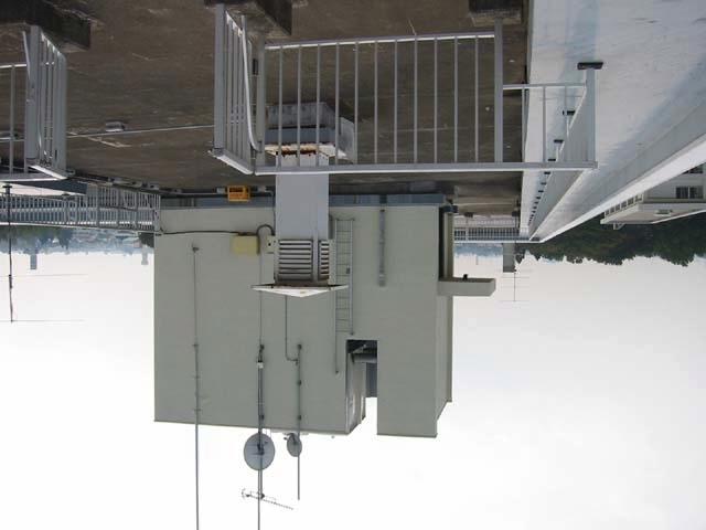
3 DGPS under multiapth condition Height (m) GPSTime (s) Non Multipath Estimation, Non Smoothing *Novatel RT-2 *Mask 5 degrees *Csmooth 20s *Model502 Ant. (choke-ring) Reference station was installed under clear condition. Rover station was installed under multipath condition. Next picture shows the environment around rover station.
4
5 C/N0 Code Multipath (m) SV SV SV GPSTime (s) SV22 : 0m offset SV8 : +7m offset SV27 : -7m offset GPSTime (s) This picture shows C/N 0 in rover station. Main reason SV8: Reflection by Wall SV22: Reflection by BWO SV27: Diffraction This picture shows Code Multipath in rover station. BWO: Box for Weather Observation
6 Purpose Observing effects of code multipath due to near obstruction. Estimating code multipath due to near obstruction as correctly as we can. Improving accuracy in case of shortdelay code multipath. (Short period and long period test)
7 Multipath effect on pseudorange (1) In principal, code multipath can be estimated if we can parameterize signal amplitude, time delay, and phase of multipath. When GPS rover antenna moves, it is very difficult to estimate them. Because multipath parameters vary according to the environments. But in case of stationary antenna, we can almost estimate multipath parameters.
8 Multipath effect on pseudorange (2) Multipath error Direct signal Reflected signal Time delay(chip) Correlation peak with constructive interference from a reflected signal This picture shows correlation peak contaminated by a reflected signal. Most GPS receivers use a DLL (early-late correlator) to track the signal. 30 Multipath error (m) chip 1.0chip Relative Multipath Amplitude = This picture shows bounds on C/A code error due to multipath. Differential path length (m)
9 Target Specular code multipath L1-L2 GPS receiver (carrier phase output) Static DGPS Code-minus-carrier (m) GPSTime (s) GPS Antenna was installed near the wall (3.5m) 30minutes data SV with many cycle-slips are removed
10 Steps for estimating code multipath Detect cycle-slips. Determine cycle-slip free interval each SV. (Max 30 minutes) Calculation of zero-mean code multipath from code-carrier technique. (A) Estimation of multipath parameters from Satellite-GPS Antenna geometry. Determine mean code multipath. (B) New code multipath is estimated from both A and B.
11 Method to estimate code multipath Variation is almost correct, but mean can t be estimated. Estimation of multipath parameters Code-minus-carrier technique + Mean code multipath New code multipath
12 Estimation example Code-minus-carrier (m) GPSTime (s) Code multipath (m) delay (m) 0-mean code multipath variation from code-carrier technique Code multipath from multipath parameters. Amplitude=0.15 New code multipath = Variation of code multipath + Mean code multipath
13 DGPS TEST Rover station is 3.5m from the wall. Reference station is installed under clear condition. Applying new code multipath to pseudoranges in rover station. Short and long period. RT-2 GPS Receiver and Model 502 Antenna Wall BWO Funnel (choke-ring) * Rover station 10m Reference station * Rooftop Antenna Configuration
14 Steps for DGPS Produce correction data from measurements of reference station Produce new code multipath in rover station Produce new pseudorange in rover station. (raw pseudorange + new code multipath + correction) Calculate the rover position by least square method
15 Short period test (1) Height error (m) Height error (m) GPSTime (s) GPSTime (s) No multipath estimation No carrier smoothing 6m (max variation) 1.19m (height 1σ) Multipath estimation No carrier smoothing 2m (max variation) 0.40m (height 1σ) Precise height : 81.00m
16 Short period test (2) Height error (m) GPSTime (s) No multipath estimation Carrier smoothing (100s) 3m (max variation) 0.74m (height 1σ) Height error (m) GPSTime (s) Multipath estimation Carrier smoothing (100s) 0.5m (max variation) 0.10m (height 1σ) Precise height : 81.00m
17 Long period test MPE: Multipath Estimation 1) Antenna-Wall (3m, 15hours) Pattern Height Horizontal Average No MPE 1.12m 0.76m 81.22m MPE(zero-mean) 0.57m 0.25m 81.21m MPE(+mean) 0.40m 0.22m 81.18m 2) Antenna-Wall (7m, 15hours) No MPE 0.70m 0.55m 81.09m MPE(zero-mean) 0.27m 0.23m 81.19m MPE(+mean) 0.19m 0.17m 81.05m DGPS accuracy (1σ) on MP estimation methods
18 Conclusion Code minus carrier technique can approximately estimate code multipath. Mean code multipath can be calculated by estimating multipath parameters and accuracy is a little better than only code multipath. We will apply this new technique to correction generating in reference station. The future object is to build technique to estimate code multiapth in real-time and to enhance robustness of this technique.
The Possibility of Precise Automobile Navigation using GPS/QZS L5 and (Galileo E5) Pseudo ranges
 Pseudo ranges") The Possibility of Precise Automobile Navigation using GPS/QZS L5 and (Galileo E5 Pseudo ranges ION ITM ITM 013 Hiroko Tokura, Taro Suzuki, Tomoji Takasu, Nobuaki Kubo (Tokyo University of Marine Scienceand
The Possibility of Precise Automobile Navigation using GPS/QZS L5 and (Galileo E5 Pseudo ranges ION ITM ITM 013 Hiroko Tokura, Taro Suzuki, Tomoji Takasu, Nobuaki Kubo (Tokyo University of Marine Scienceand
How multipath error influences on ambiguity resolution
 How multipath error influences on ambiguity resolution Nobuaki Kubo, Akio Yasuda Tokyo University of Mercantile Marine BIOGRAPHY Nobuaki Kubo received his Master of Engineering (Electrical) in 99 from
The Benefits of Three Frequencies for the High Accuracy Positioning
 The Benefits of Three Frequencies for the High Accuracy Positioning Nobuaki Kubo (Tokyo University of Marine and Science Technology) Akio Yasuda (Tokyo University of Marine and Science Technology) Isao
Performance Evaluation of the Effect of QZS (Quasi-zenith Satellite) on Precise Positioning
 on Precise Positioning") Performance Evaluation of the Effect of QZS (Quasi-zenith Satellite) on Precise Positioning Nobuaki Kubo, Tomoko Shirai, Tomoji Takasu, Akio Yasuda (TUMST) Satoshi Kogure (JAXA) Abstract The quasi-zenith
Performance Evaluation of the Effect of QZS (Quasi-zenith Satellite) on Precise Positioning Nobuaki Kubo, Tomoko Shirai, Tomoji Takasu, Akio Yasuda (TUMST) Satoshi Kogure (JAXA) Abstract The quasi-zenith
and Vehicle Sensors in Urban Environment
 AvailabilityImprovement ofrtk GPS GPSwithIMU and Vehicle Sensors in Urban Environment ION GPS/GNSS 2012 Tk Tokyo University it of Marine Si Science and Technology Nobuaki Kubo, Chen Dihan 1 Contents Background
AIRPORT MULTIPATH SIMULATION AND MEASUREMENT TOOL FOR SITING DGPS REFERENCE STATIONS
 AIRPORT MULTIPATH SIMULATION AND MEASUREMENT TOOL FOR SITING DGPS REFERENCE STATIONS ABSTRACT Christophe MACABIAU, Benoît ROTURIER CNS Research Laboratory of the ENAC, ENAC, 7 avenue Edouard Belin, BP
Test Results from a Digital P(Y) Code Beamsteering Receiver for Multipath Minimization Alison Brown and Neil Gerein, NAVSYS Corporation
 Code Beamsteering Receiver for Multipath Minimization Alison Brown and Neil Gerein, NAVSYS Corporation") Test Results from a Digital P(Y) Code Beamsteering Receiver for ultipath inimization Alison Brown and Neil Gerein, NAVSYS Corporation BIOGRAPHY Alison Brown is the President and CEO of NAVSYS Corporation.
Test Results from a Digital P(Y) Code Beamsteering Receiver for ultipath inimization Alison Brown and Neil Gerein, NAVSYS Corporation BIOGRAPHY Alison Brown is the President and CEO of NAVSYS Corporation.
Using a Sky Projection to Evaluate Pseudorange Multipath and to Improve the Differential Pseudorange Position
 Using a Sky Projection to Evaluate Pseudorange Multipath and to Improve the Differential Pseudorange Position Dana G. Hynes System Test Group, NovAtel Inc. BIOGRAPHY Dana Hynes has been creating software
Multipath and Atmospheric Propagation Errors in Offshore Aviation DGPS Positioning
 Multipath and Atmospheric Propagation Errors in Offshore Aviation DGPS Positioning J. Paul Collins, Peter J. Stewart and Richard B. Langley 2nd Workshop on Offshore Aviation Research Centre for Cold Ocean
TEST RESULTS OF A HIGH GAIN ADVANCED GPS RECEIVER
 TEST RESULTS OF A HIGH GAIN ADVANCED GPS RECEIVER ABSTRACT Dr. Alison Brown, Randy Silva, Gengsheng Zhang,; NAVSYS Corporation. NAVSYS High Gain Advanced GPS Receiver () uses a digital beam-steering antenna
ION ITM Tokyo University of Marine Science and Technology H. Sridhara, N. Kubo, R.Kikuchi
 Single-Frequency Multi-GNSS RTK Positioning for Moving Platform ION ITM 215 215.1.27-29 Tokyo University of Marine Science and Technology H. Sridhara, N. Kubo, R.Kikuchi 1 Agenda Motivation and Background
Evaluation of the pseudorange performance by using software GPS receiver
 Journal of Global Positioning Systems (005) Vol. 4, No. 1-: 15- Evaluation of the pseudorange performance by using software GPS receiver Shun-Ichiro Kondo, Nobuaki Kubo and Akio Yasuda -1-6 Etchujima Koto-ku
HIGH GAIN ADVANCED GPS RECEIVER
 ABSTRACT HIGH GAIN ADVANCED GPS RECEIVER NAVSYS High Gain Advanced () uses a digital beam-steering antenna array to enable up to eight GPS satellites to be tracked, each with up to dbi of additional antenna
ABSTRACT: Three types of portable units with GNSS raw data recording capability are assessed to determine static and kinematic position accuracy
 ABSTRACT: Three types of portable units with GNSS raw data recording capability are assessed to determine static and kinematic position accuracy under various environments using alternatively their internal
It is well known that GNSS signals
 GNSS Solutions: Multipath vs. NLOS signals GNSS Solutions is a regular column featuring questions and answers about technical aspects of GNSS. Readers are invited to send their questions to the columnist,
Guide to GNSS Base stations
 Guide to GNSS Base stations Outline Introduction Example of a base station (TUMSAT) Preparation for setting up a base station Procedure for setting up a base station Examples at two other universities
POWERGPS : A New Family of High Precision GPS Products
 POWERGPS : A New Family of High Precision GPS Products Hiroshi Okamoto and Kazunori Miyahara, Sokkia Corp. Ron Hatch and Tenny Sharpe, NAVCOM Technology Inc. BIOGRAPHY Mr. Okamoto is the Manager of Research
GPS PERFORMANCE EVALUATION OF THE HUAWEI MATE 9 WITH DIFFERENT ANTENNA CONFIGURATIONS
 GPS PERFORMANCE EVALUATION OF THE HUAWEI MATE 9 WITH DIFFERENT ANTENNA CONFIGURATIONS AND P10 IN THE FIELD Gérard Lachapelle & Research Team PLAN Group, University of Calgary (http://plan.geomatics.ucalgary.ca)
GPS Accuracy Comparison. Tom Biernacki Florida Department of Environmental Protection
 GPS Accuracy Comparison Tom Biernacki Florida Department of Environmental Protection What Effects the accuracy of GPS? Atmospheric delay Multipath bounce Weak receiver algorithms Atmospheric Delay Signal
Affordable Differential GPS. Ben Nizette and Andrew Tridgell Australian National University CanberraUAV
 Affordable Differential GPS Ben Nizette and Andrew Tridgell Australian National University CanberraUAV Better positioning cheaply! Very accurate GPS systems are possible, but expensive Can we build one
Prototype Software-based Receiver for Remote Sensing using Reflected GPS Signals. Dinesh Manandhar The University of Tokyo
 Prototype Software-based Receiver for Remote Sensing using Reflected GPS Signals Dinesh Manandhar The University of Tokyo dinesh@qzss.org 1 Contents Background Remote Sensing Capability System Architecture
TREATMENT OF DIFFRACTION EFFECTS CAUSED BY MOUNTAIN RIDGES
 TREATMENT OF DIFFRACTION EFFECTS CAUSED BY MOUNTAIN RIDGES Rainer Klostius, Andreas Wieser, Fritz K. Brunner Institute of Engineering Geodesy and Measurement Systems, Graz University of Technology, Steyrergasse
Assessment of high-rate GPS using a single-axis shake table
 Assessment of high-rate GPS using a single-axis shake table S. Häberling, M. Rothacher, A. Geiger Institute of Geodesy and Photogrammetry, ETH Zurich Introduction Project: Study the applicability of high-rate
Introduction to GNSS Base-Station
 Introduction to GNSS Base-Station Dinesh Manandhar Center for Spatial Information Science The University of Tokyo Contact Information: dinesh@iis.u-tokyo.ac.jp Slide : 1 Introduction GPS or GNSS observation
New Approach for Tsunami Detection Based on RTK-GNSS Using Network of Ships
 New Approach for Tsunami Detection Based on RTK-GNSS Using Network of Ships Tokyo University of Marine Science and Technology Ryuta Nakaosone Nobuaki Kubo Background After the Indian Ocean Tsunami on 2004,
APPLICATION NOTE. Simulating Multipath
 APPLICATION NOTE Simulating Multipath Spirent Communications PLC Paignton, Devon, TQ4 7QR, England Web: http://www.spirent.com/positioning Tel: +44 1803 546325 Fax: +44 1803 546301 Copyright 2011 Spirent.
Effect of Quasi Zenith Satellite (QZS) on GPS Positioning
 on GPS Positioning") Effect of Quasi Zenith Satellite (QZS) on GPS ing Tomoji Takasu 1, Takuji Ebinuma 2, and Akio Yasuda 3 Laboratory of Satellite Navigation, Tokyo University of Marine Science and Technology 1 (Tel: +81-5245-7365,
Effect of Quasi Zenith Satellite (QZS) on GPS ing Tomoji Takasu 1, Takuji Ebinuma 2, and Akio Yasuda 3 Laboratory of Satellite Navigation, Tokyo University of Marine Science and Technology 1 (Tel: +81-5245-7365,
Multipath Error Detection Using Different GPS Receiver s Antenna
 Multipath Error Detection Using Different GPS Receiver s Antenna Md. Nor KAMARUDIN and Zulkarnaini MAT AMIN, Malaysia Key words: GPS, Multipath error detection, antenna residual SUMMARY The use of satellite
LOCAL DEFORMATION MONITORING USING REAL-TIME GPS KINEMATIC TECHNOLOGY: INITIAL STUDY
 LOCAL DEFORMATION MONITORING USING REAL-TIME GPS KINEMATIC TECHNOLOGY: INITIAL STUDY Donghyun (Don) Kim, Richard B. Langley, Jason Bond, and Adam Chrzanowski Department of Geodesy and Geomatics Engineering
SYSTEMATIC EFFECTS IN GPS AND WAAS TIME TRANSFERS
 SYSTEMATIC EFFECTS IN GPS AND WAAS TIME TRANSFERS Bill Klepczynski Innovative Solutions International Abstract Several systematic effects that can influence SBAS and GPS time transfers are discussed. These
SX-NSR 2.0 A Multi-frequency and Multi-sensor Software Receiver with a Quad-band RF Front End
 SX-NSR 2.0 A Multi-frequency and Multi-sensor Software Receiver with a Quad-band RF Front End - with its use for Reflectometry - N. Falk, T. Hartmann, H. Kern, B. Riedl, T. Pany, R. Wolf, J.Winkel, IFEN
Procedures for Quality Control of GNSS Surveying Results Based on Network RTK Corrections.
 Procedures for Quality Control of GNSS Surveying Results Based on Network RTK Corrections. Limin WU, China Feng xia LI, China Joël VAN CRANENBROECK, Switzerland Key words : GNSS Rover RTK operations, GNSS
One Source for Positioning Success
 novatel.com One Source for Positioning Success RTK, PPP, SBAS OR DGNSS. NOVATEL CORRECT OPTIMIZES ALL CORRECTION SOURCES, PUTTING MORE POWER, FLEXIBILITY AND CONTROL IN YOUR HANDS. NovAtel CORRECT is the
TSC1 - Asset Surveyor Operation
 TSC1 - Asset Surveyor Operation Menu Icons (current choice is highlighted) Data collection File manager Main menu Navigation GPS Position Battery Status PC Card (if used) Real-Time Status Number of Satellites
GPS STATIC-PPP POSITIONING ACCURACY VARIATION WITH OBSERVATION RECORDING INTERVAL FOR HYDROGRAPHIC APPLICATIONS (ASWAN, EGYPT)
") GPS STATIC-PPP POSITIONING ACCURACY VARIATION WITH OBSERVATION RECORDING INTERVAL FOR HYDROGRAPHIC APPLICATIONS (ASWAN, EGYPT) Ashraf Farah Associate Professor,College of Engineering, Aswan University,
GPS STATIC-PPP POSITIONING ACCURACY VARIATION WITH OBSERVATION RECORDING INTERVAL FOR HYDROGRAPHIC APPLICATIONS (ASWAN, EGYPT) Ashraf Farah Associate Professor,College of Engineering, Aswan University,
GPS Signal Degradation Analysis Using a Simulator
 GPS Signal Degradation Analysis Using a Simulator G. MacGougan, G. Lachapelle, M.E. Cannon, G. Jee Department of Geomatics Engineering, University of Calgary M. Vinnins, Defence Research Establishment
UCGE Reports Number 20054
 UCGE Reports Number 20054 Department of Geomatics Engineering An Analysis of Some Critical Error Sources in Static GPS Surveying (URL: http://www.geomatics.ucalgary.ca/links/gradtheses.html) by Weigen
FieldGenius Technical Notes GPS Differential Corrections
 FieldGenius Technical tes GPS Differential Corrections Introduction The accuracy requirement of survey grade or mapping grade GPS applications for real time positioning requires the use of differential
Testing Multipath Performance of GNSS Receivers
 Testing Multipath Performance of GNSS Receivers How multipath simulation can be used to evaluate the effects of multipath on the performance of GNSS receivers SPIRENT ebook 1 of 28 The multipath phenomenon
Appendix D Brief GPS Overview
 Appendix D Brief GPS Overview Global Positioning System (GPS) Theory What is GPS? The Global Positioning System (GPS) is a satellite-based navigation system, providing position information, accurate to
On multipath characterization through software receivers and ray-tracing
 On multipath characterization through software receivers and ray-tracing Marios Smyrnaios 1, Steffen Schön 1, Marcos Liso 2, Thomas Kürner 2 1 Institut für Erdmessung (IfE), Leibniz-Universität Hannover
Modelling GPS Observables for Time Transfer
 Modelling GPS Observables for Time Transfer Marek Ziebart Department of Geomatic Engineering University College London Presentation structure Overview of GPS Time frames in GPS Introduction to GPS observables
Evaluation of L2C Observations and Limitations
 Evaluation of L2C Observations and Limitations O. al-fanek, S. Skone, G.Lachapelle Department of Geomatics Engineering, Schulich School of Engineering, University of Calgary, Canada; P. Fenton NovAtel
ENGI 3703 Surveying and Geomatics
 Satellite Geometry: Satellites well spread out in the sky have a much stronger solution to the resection type problem (aka trilateration) then satellite that are grouped together. Since the position of
Framework and Performance Evaluation of a Ray Tracing-Software Defined Radio Method for GNSS Positioning in an Urban Canyon Environment
 Framework and Performance Evaluation of a Ray Tracing-Software Defined Radio Method for GNSS Positioning in an Urban Canyon Environment Rei Furukawa, Kozo Keikaku Engineering Inc., Tokyo University of
1. Discuss in detail the Design Consideration of a Satellite Communication Systems. [16]
![1. Discuss in detail the Design Consideration of a Satellite Communication Systems. [16]](/thumbs/86/93666103.jpg "1. Discuss in detail the Design Consideration of a Satellite Communication Systems. [16]") Code No: R05410409 Set No. 1 1. Discuss in detail the Design Consideration of a Satellite Communication Systems. 2. (a) What is a Geosynchronous Orbit? Discuss the advantages and disadvantages of these
Code No: R05410409 Set No. 1 1. Discuss in detail the Design Consideration of a Satellite Communication Systems. 2. (a) What is a Geosynchronous Orbit? Discuss the advantages and disadvantages of these
OHIO UNIVERSITY LIBRARY
 MULTIPATH ERRORS INDUCED BY ELECTRONIC COMPONENTS IN RECEIVER HARD WARE A Thesis Presented to The Faculty of the Fritz J. and Dolores H. Russ College of Engineering and Technology Ohio University In Partial
FieldGenius Technical Notes GPS Terminology
 FieldGenius Technical Notes GPS Terminology Almanac A set of Keplerian orbital parameters which allow the satellite positions to be predicted into the future. Ambiguity An integer value of the number of
Tersus RTK Competitive Analysis
 Test Report Jun 2018 Tersus RTK Competitive Analysis 2018 Tersus GNSS Inc. All rights reserved. Sales & Technical Support: sales@tersus-gnss.com & support@tersus-gnss.com More details, please visit www.tersus-gnss.com
ISG & ISPRS 2011, Sept , 2011 Shah Alam, MALAYSIA
 ISG & ISPRS 2011, Sept. 27-29, 2011 Shah Alam, MALAYSIA THE PERFORMANCE OF ISKANDARnet DGPS SERVICE Wan Aris. W. A. 1, Musa., T. A. 1, Othman. R 1 GNSS & Geodynamic Research Group, Faculty of Geoinformation
GNSS & Coordinate Systems
 GNSS & Coordinate Systems Matthew McAdam, Marcelo Santos University of New Brunswick, Department of Geodesy and Geomatics Engineering, Fredericton, NB May 29, 2012 Santos, 2004 msantos@unb.ca 1 GNSS GNSS
Several ground-based augmentation system (GBAS) Galileo E1 and E5a Performance
 Galileo E1 and E5a Performance") » COVER STORY Galileo E1 and E5a Performance For Multi-Frequency, Multi-Constellation GBAS Analysis of new Galileo signals at an experimental ground-based augmentation system (GBAS) compares noise and
» COVER STORY Galileo E1 and E5a Performance For Multi-Frequency, Multi-Constellation GBAS Analysis of new Galileo signals at an experimental ground-based augmentation system (GBAS) compares noise and
TESTING MULTIPATH PERFORMANCE of GNSS Receivers
 TESTING MULTIPATH PERFORMANCE of GNSS Receivers How multipath simulation can be used to evaluate the effects of multipath on the performance of GNSS receivers Spirent ebook 1 The multipath phenomenon Multipath
A GPS RECEIVER DESIGNED FOR CARRIER-PHASE TIME TRANSFER
 A GPS RECEIVER DESIGNED FOR CARRIER-PHASE TIME TRANSFER Alison Brown, Randy Silva, NAVSYS Corporation and Ed Powers, US Naval Observatory BIOGRAPHY Alison Brown is the President and CEO of NAVSYS Corp.
The Possibility of Precise Positioning in the Urban Area
 Presented at GNSS 004 The 004 International Symposium on GNSS/GPS Sydney, Australia 6 8 December 004 The Possibility of Precise Positioning in the Urban Area Nobuai Kubo Toyo University of Marine Science
Data Acquisition Experiment using NovAtel Dual Frequency GPS Receiver
 Data Acquisition Experiment using NovAtel Dual Frequency GPS Receiver Dhiraj Sunehra Jawaharlal Nehru Technological University Hyderabad, Andhra Pradesh, India Abstract The advent of very large scale integration
Guide to GNSS Base stations
 Guide to GNSS Base stations Outline Introduction Example of Base Station (TUMSAT) Preparation for setting up a base station Procedure for setting up a base station Example of each Univ. Based on documents
Precise Point Positioning (PPP) using
 using") Precise Point Positioning (PPP) using Product Technical Notes // May 2009 OnPOZ is a product line of Effigis. EZSurv is a registered trademark of Effigis. All other trademarks are registered or recognized
Precise Point Positioning (PPP) using Product Technical Notes // May 2009 OnPOZ is a product line of Effigis. EZSurv is a registered trademark of Effigis. All other trademarks are registered or recognized
Precise Positioning with NovAtel CORRECT Including Performance Analysis
 Precise Positioning with NovAtel CORRECT Including Performance Analysis NovAtel White Paper April 2015 Overview This article provides an overview of the challenges and techniques of precise GNSS positioning.
The Case for Narrowband Receivers
 The Case for Narrowband Receivers R. Eric Phelts, Per Enge Department of Aeronautics and Astronautics, Stanford University BIOGRAPHY R. Eric Phelts is a Ph.D. candidate in the Department of Aeronautics
New Guide to GNSS Base stations
 New Guide to GNSS Base stations Asian Base Stations Project Updated on December 2017 Outline 1 st Chapter (page3 page25) -Setting of The Base Station- Introduction Example of base Station (TUMSAT) Preparation
MGA Webinar Series : 1 Very Cheap RTK Receivers: Changing the Landscape of Positioning Services
 MGA Webinar Series : 1 Very Cheap RTK Receivers: Changing the Landscape of Positioning Services Dinesh Manandhar Center for Spatial Information Science The University of Tokyo Contact Information: dinesh@iis.u-tokyo.ac.jp
TEST RESULTS OF A DIGITAL BEAMFORMING GPS RECEIVER FOR MOBILE APPLICATIONS
 TEST RESULTS OF A DIGITAL BEAMFORMING GPS RECEIVER FOR MOBILE APPLICATIONS Alison Brown, Huan-Wan Tseng, and Randy Kurtz, NAVSYS Corporation BIOGRAPHY Alison Brown is the President and CEO of NAVSYS Corp.
Improved GPS Carrier Phase Tracking in Difficult Environments Using Vector Tracking Approach
 Improved GPS Carrier Phase Tracking in Difficult Environments Using Vector Tracking Approach Scott M. Martin David M. Bevly Auburn University GPS and Vehicle Dynamics Laboratory Presentation Overview Introduction
GPS Antenna Design and Performance Advancements: The Trimble Zephyr
 GPS Antenna Design and Performance Advancements: The Trimble Zephyr Eric Krantz and Dr. Stuart Riley, Trimble GPS Engineering and Construction Group, Sunnyvale, California, USA. Pete Large, Trimble Integrated
MULTIPATH EFFECT MITIGATION IN SIGNAL PROPAGATION THROUGH AN INDOOR ENVIRONMENT
 JOURNAL OF APPLIED ENGINEERING SCIENCES VOL. 2(15), issue 2_2012 ISSN 2247-3769 ISSN-L 2247-3769 (Print) / e-issn:2284-7197 MULTIPATH EFFECT MITIGATION IN SIGNAL PROPAGATION THROUGH AN INDOOR ENVIRONMENT
POLARX2, A NEW GPS RECEIVER FOR GEODETIC APPLICATIONS. Table of Contents
 POLARX2, A NEW GPS RECEIVER FOR GEODETIC APPLICATIONS Andrew Simsky(Septentrio, Belgium a.simsky@septentrio.com), Jean-Marie Sleewaegen (Septentrio, Belgium jm.sleewaegen@septentrio.com), and Carine Bruyninx
How Effective Are Signal. Quality Monitoring Techniques
 How Effective Are Signal Quality Monitoring Techniques for GNSS Multipath Detection? istockphoto.com/ppampicture An analytical discussion on the sensitivity and effectiveness of signal quality monitoring
Real-Time Processing Strategies
 Publikation_en_Sept_2001 30.11.2001 14:08 Uhr Seite 1 30 40 50 Real-Time Processing Strategies Study of Improved Observation Modeling for Surveying Type Applications in Multipath Environment Bernhard Richter
The Global Positioning System
 The Global Positioning System 5-1 US GPS Facts of Note DoD navigation system First launch on 22 Feb 1978, fully operational in 1994 ~$15 billion (?) invested to date 24 (+/-) Earth-orbiting satellites
Advances in GNSS Technology and it s Application to Tidal Derivation
 Advances in GNSS Technology and it s Application to Tidal Derivation Tim Painter Chief Surveyor Fugro Survey Africa Pty Ltd John Vint Survey and Starfix Product Manager Fugro Survey AS, Norway Scope of
GPS Performance in Southern Hardwood Forests
 GPS Performance in Southern Hardwood Forests Pete Bettinger Warnell School of Forestry and Natural Resources University of Georgia In forests, vegetation plays a significant role in obstructing signals
Chapter 6. Temperature Effects
 Chapter 6. Temperature Effects 6.1 Introduction This chapter documents the investigation into temperature drifts that can cause a receiver clock bias even when a stable reference is used. The first step
Digital Land Surveying and Mapping (DLS and M) Dr. Jayanta Kumar Ghosh Department of Civil Engineering Indian Institute of Technology, Roorkee
 Dr. Jayanta Kumar Ghosh Department of Civil Engineering Indian Institute of Technology, Roorkee") Digital Land Surveying and Mapping (DLS and M) Dr. Jayanta Kumar Ghosh Department of Civil Engineering Indian Institute of Technology, Roorkee Lecture 11 Errors in GPS Observables Welcome students. Lesson
Digital Land Surveying and Mapping (DLS and M) Dr. Jayanta Kumar Ghosh Department of Civil Engineering Indian Institute of Technology, Roorkee Lecture 11 Errors in GPS Observables Welcome students. Lesson
GPS Milestones, cont. GPS Milestones. The Global Positioning Sytem, Part 1 10/10/2017. M. Helper, GEO 327G/386G, UT Austin 1. US GPS Facts of Note
 The Global Positioning System US GPS Facts of Note DoD navigation system First launch on 22 Feb 1978, fully operational in 1994 ~$15 billion (?) invested to date 24 (+/-) Earth-orbiting satellites (SVs)
Global Positioning System: what it is and how we use it for measuring the earth s movement. May 5, 2009
 Global Positioning System: what it is and how we use it for measuring the earth s movement. May 5, 2009 References Lectures from K. Larson s Introduction to GNSS http://www.colorado.edu/engineering/asen/
GPS Performance in Southern Hardwood Forests Pete Bettinger Warnell School of Forestry and Natural Resources University of Georgia
 GPS Performance in Southern Hardwood Forests Pete Bettinger Warnell School of Forestry and Natural Resources University of Georgia Introduction In forests, vegetation plays a significant role in obstructing
Carrier Phase Multipath Corrections Based on GNSS Signal Quality Measurements to Improve CORS Observations
 Carrier Phase Multipath Corrections Based on GNSS Signal Quality Measurements to Improve CORS Observations Christian Rost and Lambert Wanninger Geodetic Institute Technische Universität Dresden Dresden,
Satellite Bias Corrections in Geodetic GPS Receivers
 Satellite Bias Corrections in Geodetic GPS Receivers Demetrios Matsakis, The U.S. Naval Observatory (USNO) Stephen Mitchell, The U.S. Naval Observatory Edward Powers, The U.S. Naval Observatory BIOGRAPHY
GL1DE. Introducing NovAtel s. Technology. Precise thinking.
 Introducing NovAtel s GLDE Technology Precise thinking 28 NovAtel Inc. All rights reserved. Printed in Canada. D239 www.novatel.com -8-NOVATEL (U.S. & Canada) or 43-295-49 Europe +44 () 993 852-436 SE
Multi-Receiver Vector Tracking
 Multi-Receiver Vector Tracking Yuting Ng and Grace Xingxin Gao please feel free to view the.pptx version for the speaker notes Cutting-Edge Applications UAV formation flight remote sensing interference
UCGE Reports Number Augmentation of GPS with Pseudolites in a Marine Environment. Thomas G. Morley. Department of Geomatics Engineering
 Geomatics Engineering UCGE Reports Number 218 Department of Geomatics Engineering Augmentation of GPS with Pseudolites in a Marine Environment By Thomas G. Morley May, 1997 Calgary, Alberta, Canada THE
Pseudorange Multipath Mitigation By Means of Multipath Monitoring and De-Weighting
 Pseudorange Multipath Mitigation By Means of Multipath Monitoring and De-Weighting Sunil B. Bisnath and Richard B. Langley Geodetic Research Laboratory, Department of Geodesy and Geomatics Engineering,
Geodetic Reference via Precise Point Positioning - RTK
 2012 Geo++ GmbH Geodetic Reference via Precise Point Positioning - RTK Gerhard Wübbena Geo++ GmbH 30827 Garbsen Germany www.geopp.de 2012 Geo++ GmbH Contents Terms and Abbreviations GNSS Principles GNSS
High Precision GNSS in Automotive
 High Precision GNSS in Automotive Jonathan Auld, VP Engineering and Safety 6, March, 2018 2 Global OEM Positioning Solutions and Services for Land, Sea, and Air. GNSS in Automotive Today Today the primary
Low-Cost GNSS for Geodetic Applications
 Institut für Ingenieurgeodäsie Presented at the FIG Congress 2018, May 6-11, 2018 in Istanbul, Turkey Low-Cost GNSS for Geodetic Applications Dr.-Ing. Li Zhang Institute of Engineering Geodesy (IIGS),
Posicionamento por ponto com. Posicionamento por satélite UNESP PP 2017 Prof. Galera
 Posicionamento por ponto com multiconstelação GNSS Posicionamento por satélite UNESP PP 2017 Prof. Galera Single-GNSS Observation Equations Considering j = 1; : : : ; f S the frequencies of a certain GNSS
Soil Moisture Observation Utilizing Reflected GNSS Signals
 Soil Moisture Observation Utilizing Reflected GNSS Signals GNSS-R Tech in Soil Moisture New Data Processing Method Prof. Dongkai YANG Joint African/Asia-Pacific UN-Regional Centers and International Training
Utilizing Batch Processing for GNSS Signal Tracking
 Utilizing Batch Processing for GNSS Signal Tracking Andrey Soloviev Avionics Engineering Center, Ohio University Presented to: ION Alberta Section, Calgary, Canada February 27, 2007 Motivation: Outline
SPAN Technology System Characteristics and Performance
 SPAN Technology System Characteristics and Performance NovAtel Inc. ABSTRACT The addition of inertial technology to a GPS system provides multiple benefits, including the availability of attitude output
Bernhard Hofnlann-Wellenhof Herbert Lichtenegger Elmar Wasle. GNSS - Global Navigation Satellite Systenls. GPS, GLONASS, Galileo, and nl0re
 Bernhard Hofnlann-Wellenhof Herbert Lichtenegger Elmar Wasle GNSS - Global Navigation Satellite Systenls GPS, GLONASS, Galileo, and nl0re SpringerWienNewYork Contents Abbreviations xxi 1 Introduction 1
GPS positioning using map-matching algorithms, drive restriction information and road network connectivity
 Extended abstract Submission for GISRUK 2001 GPS positioning using map-matching algorithms, drive restriction information and road network connectivity George Taylor 1, Jamie Uff 2 and Adil Al-Hamadani
Using GPS in Embedded Applications Pascal Stang Stanford University - EE281 November 28, 2000
 Using GPS in Embedded Applications Pascal Stang Stanford University - EE281 INTRODUCTION Brief history of GPS Transit System NavStar (what we now call GPS) Started development in 1973 First four satellites
REAL-TIME GPS ATTITUDE DETERMINATION SYSTEM BASED ON EPOCH-BY-EPOCH TECHNOLOGY
 REAL-TIME GPS ATTITUDE DETERMINATION SYSTEM BASED ON EPOCH-BY-EPOCH TECHNOLOGY Dr. Yehuda Bock 1, Thomas J. Macdonald 2, John H. Merts 3, William H. Spires III 3, Dr. Lydia Bock 1, Dr. Jeffrey A. Fayman
Guochang Xu GPS. Theory, Algorithms and Applications. Second Edition. With 59 Figures. Sprin ger
 Guochang Xu GPS Theory, Algorithms and Applications Second Edition With 59 Figures Sprin ger Contents 1 Introduction 1 1.1 AKeyNoteofGPS 2 1.2 A Brief Message About GLONASS 3 1.3 Basic Information of Galileo
Satellite Navigation Principle and performance of GPS receivers
 Satellite Navigation Principle and performance of GPS receivers AE4E08 GPS Block IIF satellite Boeing North America Christian Tiberius Course 2010 2011, lecture 3 Today s topics Introduction basic idea
MONITORING SEA LEVEL USING GPS
 38 MONITORING SEA LEVEL USING GPS Hasanuddin Z. Abidin* Abstract GPS (Global Positioning System) is a passive, all-weather satellite-based navigation and positioning system, which is designed to provide
Positioning with Single and Dual Frequency Smartphones Running Android 7 or Later
 Positioning with Single and Dual Frequency Smartphones Running Android 7 or Later * René Warnant, *Laura Van De Vyvere, + Quentin Warnant * University of Liege Geodesy and GNSS + Augmenteo, Plaine Image,
MULTIPATH MITIGATION BY WAVELET ANALYSIS FOR GPS BASE STATION APPLICATIONS
 MULTIPATH MITIGATION BY WAVELET ANALYSIS FOR GPS BASE STATION APPLICATIONS Chalermchon Satirapod 1 and Chris Rizos 2 1 Geo-Image Technology Research Unit Department of Survey Engineering Chulalongkorn
Recent Improvements to the StarFire Global DGPS Navigation Software
 Journal of Global Positioning Systems (2004) Vol. 3, No. 1-2: 143-153 Recent Improvements to the StarFire Global DGPS Navigation Software Ronald R. Hatch NavCom Technology, Inc., 20780 Madrona Avenue,