GNSS High Precision Systems for Cadastre: development, experiences and Galileo perspectives
|
|
|
- Ambrose Reed
- 5 years ago
- Views:
Transcription
1 GNSS High Precision Systems for Cadastre: development, experiences and Galileo perspectives CLGE Plenary Workshop 29 September 2017 Roberto Capua, Flavio Ferrante DO-11-DO-03 1
2 Agenda GNSS High Precision Systems Evolutions The Cadastral Land Surveying applications in Italy The Sogei GRDNet Network GPS and Galileo Integrity Monitoring Systems High Precision on Smartphones Galileo Network Upgrade Conclusions and Recommendations 2

3 The automatic cartographic updating by Pregeo 10 Institutional Software PREGEO procedure evolution PREGEO PREGEO 8 PREGEO 9 PREGEO 10 Circular n. 2/88 Simplification and standardization of the implementing rules of surveys and cadastral cartography updating procedures and the connected DB census archive too Digital management of cadastral cartography WEGIS Satellite technology use in surveys GPS Private Surveyors Involvment Updating files automatic transmission SISTER video Cadastral cartography automatic updating 2015 Cadastral updating files online trasmission becomes mandatory
4 The Italian Cadastral Maps Land Surveying Hidden points: GNSS and Topographical instruments hybridisation GNSS Baseline Cadastral Fiducial Points to be surveyed GNSS Base Point 4


5 Monitoring of Map Update Acts GNSS Surveys 700, , , , , , ,000 Total Map Update Acts Map Update Acts through GNSS 0 Total Map Update Acts Map Update Acts through GNSS %

6 Land Cadastre Update: PreGeo Procedure Type 2 PREGEO recording Row Final point of a baseline Can record any GNSS Surveying Result!
7 GNSS Augmentation System Characterization 7


8 GRDNet (GNSS R&D Network) Deployed in 2003 for providing institutional Real-Time high accuracy positioning Currently covering the central area of Italy (15 GNSS Reference Stations) Single Station, Nearest and VRS Services Fully Standard compliant (NTRIP protocol, RTCM v3.x data format) Open and Scalar Architecture, any kind of GNSS Reference Station Internally developed GNSS Control Centre Software Web Network Performances Monitoring and Control All Reference Stations are Galileo Ready
9 GRDNet Architecture EGNOS/EDAS Tier-1 GNSS Reference Stations RTCM3 RIMS Raw Data NTRIP/RTCM Real-Time GPS and Galileo Precise Worldwide RS raw data Public Interconnectivity System Users RTSP to http Bridge http Front-End Protocol: NTRIP Data Format: RTCM NTRIP Specific Control Centres OBU LDS IGS NTRIP ftp RINEX files Precise orbits/ clocks Integrity Monitoring Data Storing and Integrity Back-End Tier-2 (Sardinia RSs) Data Storing 1 U Storage Integrity Network Processing GNSS Network Management and Corrections Generation Software Storage Tek


10 Galileo High Precision Integrity Systems within Horizon 2020 Needed in several current and emerging applications (e.g. Rail, Aviation, Automotive, Automatic Driving): Federated GNSS Network High Precision and High Integrity Augmentation Systems studied for the Rail sector (ERSAT-EAV and RHINOS GSA Projects) 2-Tiers Augmentation: integrating Local Reference Stations and EGNOS RIMS for performing GNSS Signal, Reference Stations and Augmentation Systems Fault Detection and Exclusion EGNOS EDAS RIMS Raw meas. Correction mgs SIS FDE LA FDE GNSS Augmentation Control Centre Augmentation Msgs 10

11 High Precision and Integrity Current GNSS RTK and Network RTK Systems limitations: High GNSS Reference Stations Maintenance and Fault recovery costs GNSS Geodetic equipments and Service Fees for Surveyors GNSS Network Service Guarantee and Fault Monitoring Reliability, Integrity and Anti-Spoofing as a Cost-Saving factor: HP System Faults (GNSS, Augmentation and Communication!) leading to longer surveying or completely new surveys Integrity as a cost-saving factor (2 persons/day+travel+elaboration): avoiding the risk of a faulted survey for GNSS or Network Faults 11
12 GNSS High Precision Surveying Faults HP Surveying Faults On-Field GNSS HP Network GNSS SIS: Shadowing Multipath Foliage Attenuation Ephemeris and Clock Signal Deformations Ionospheric Anomalies Interferences Spoofing Mobile Comm. (RTK) Reference Station HW Faults Control Centre Software Fault Reference Station to Control Centre Comm Faults SIS and Augmentation Fault Detection and Exclusion to be integrated within the GNSS Network Galileo CS Authentication Services (OS-NMA) Multi-Constellation benefit 12

13 Web Integrity Monitoring through EGNOS Available to any user 13

14 2-Tiers GNSS Signal and Network Fault Detection and Exclusion Available to any user Threshold for Alarm Residual Testing Real-Time Monitoring Galileo Satellite Monitoring: Lowest residuals! 14
15 RTCM SC-104 WG «Integrity Monitoring for High Precision applications» 17 participating RTCM Members Main objectives of the WG are: Definition of Integrity Standard messages for High Precision Applications to be inserted within the RTCM 3.x standard Definition of Guidelines for the development of High Precision and High Integrity Local Augmentation Systems Liason with other Standardization Bodies (e.g. RTCA, SAE) 15

 Medium-High")


16 Single-Frequency COTS Low Cost RTK Receivers Hardware Receivers: Low-Cost, Single-Frequency RTK on the Market Time To Fix Ambiguities in the order of a 4-5 minutes if: Short baselines (Physical or VRS Stations) Medium-High number of visible satellites (7-9) Dual-Frequency chipset for smartphones yet on the Market! Software Receivers/SDR (Software Dedined Radio): Full SDR: Software program on a PC or a Tablet GPS/EGNOS RTK Going toward smartphone and Galileo integration 16
 Carrier Phase affected by frequent outliers GNSS antenna uses linear polarization: weak resistance to multipath Duty cycle to be disabled for")
17 High Precision for Everyone Google announced raw GNSS measurements output from smartphones and tablets running Android Nougat Smartphones Processing limitations: Bias in the carrier-phase measurements High Pseudorange noise (tens of meters) Carrier Phase affected by frequent outliers GNSS antenna uses linear polarization: weak resistance to multipath Duty cycle to be disabled for allowing continuous Phase Galileo Ready equipments still on the Market 17
 Higher performances in Urban areas (multipath resistance, higher avaiability) We are closer to a smartphone RTK")
18 High Precision on Smartphone: close to surveying Released the first Dual Frequency, multiconstellation chipset for smartphones on 21 September 2017 Signals: GPS L1/L5 GLONASS L1 Beidou B1 Galileo E1/E5a QZSS L5 Low power consumption High Precision (Code and Phase) Higher performances in Urban areas (multipath resistance, higher avaiability) We are closer to a smartphone RTK survey! 18
 Other errors to be modelled (Phase-Windup, Ocean loading and Earth tides, relativistic effects, Sagnac effect) Convergence to 10 cm in")
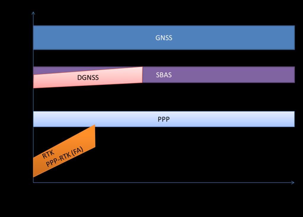
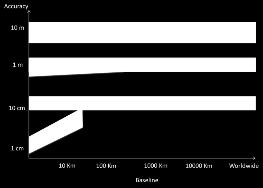
19 Precise Point Positioning (PPP) Precise Point Positioning (PPP) through a Single Receiver (no Reference Station connection) Real-Time Precise Orbits and Clocks from Augmentation Service Providers and sparse Regional/Global Reference Station Networks (low cost) Other errors to be modelled (Phase-Windup, Ocean loading and Earth tides, relativistic effects, Sagnac effect) Convergence to 10 cm in min (no Ambiguity Fix) The next objective: Real-Time PPP-RTK and cm level positioning! PPP Control Centre Precise Orbits, Clocks, Biases Ambiguity Fix 19
20 High Precision on Smarthphones: where are we? Carrier smoothed+iono estimation PPP experiment in literature: Precise satellite clock and orbits Global Ionospheric Maps Relativistic effects, Earth tides modelling Ionospheric Delay local estimation App available for testing PPP Source GPS World Banville, Diggelen, 2016 Current Limitations: Battery life Pseudoranges noise Smartphone Antenna Source GPS World Banville, Diggelen, 2016 Code only: IGSRTS+SBAS Smartphone is a candidate for low cost PPP-RTK Source: BlackdotGNSS 20
 Example of Comparison")
, 5 sats, Urban")

21 Real Cadastral Map Update through SDR (ION GNSS 2016) Example of Comparison with GNSS surveys in the Cadastral DB High PDOP (>6), 5 sats, Urban Canyons, Foliage, frequent CS TFFA < 17 min Correct fixes: in the order of 75% 21
22 Number of satellites Improvements from Galileo for High Precision Surveying Increased Availability in Urban Areas through GPS+Galileo Satellite Visibility (Visibility mask angle = 30 ) GPS+GALILEO Time of Day (hours) GPS Antispoofing: OS-NMA and Commercial Authentication services on E6, increased robustness and antispoofing for professional applications Improved Multipath Resistance Istantaneous Fixing: through Galileo Third frequency (TCAR) Precise Point Positioning: broadcasting of part of PPP corrections from Galileo satellites directly (no external communication) 22


23 Galileo only RTK Results Galileo RTK Fixed Solution Vallermosa Villasor (Sardinia-Italy) Baseline: 12.5 Km Galileo Satellite Visibility 23
24 Galileo Network-RTK Control Centre Issues Network Ambiguity Resolution at Control Centre: GPS-Galileo Intersystem Biases to be estimated Galileo GTRF to other Reference Frames Conversion Frequency Extensions and Measurement record generalization Computational Burden Improved Integrity Monitoring Performances E1 Ambiguity Fixing E5 Ambiguity Fixing E7 E8 E12 E19 E26 E E7 E8 E12 E19 E26 E


25 ROVER/SDR NETWORK Galileo Integration RoadMap for GRDNet and SDR 25
26 Galileo Integration Issues and constraints for High Precision Surveying Manufacturers constraints: Most of manufacturers are integrating E1, E5a, E5b, E5 Galileo Signals E6 implemented only by one manufaturer Commercial Services ICD The use of Galileo measurements for RTK for some manufacturers is optional and subject to the payment of a firmware update Some manufacturers do not correctly decode Galileo Ephemeris (both geodetic and Mass Market receivers) Galileo Services for Network-RTK Operators: GGSP: Galileo Precise Orbits and Clocks solutions, as well as ERP parameters for PPP and Control Network Adjustment using Galileo GTRF: INSPIRE Directive recommends the use of ETRF2000 for Public Administration services; could be important having the transformation parameters from GTRF to ETRF2000 provided directly by the GGSP 26
27 Suggestions for improving the introduction of Galileo To involve GNSS High Precision Service Providers and Land Administrations in the Galileo Commercial Services Validation Phase (GGSP Products validation) To involve GNSS Network Operators in Galileo Broadcasting channel tests: very interesting to test the Commercial Services broadcasting capability, compliance to current RTCM standards or update to meet the available message length To help Network Operators to sustain Reference Stations firmware upgrade in the early period after Galileo FOC (Agreement with Manufacturers) EGNOS/EDAS: introduce multiple-frequency capability To promote the integration of Networks to be used for different applications (Federated Network) To ensure that Galileo for RTK is included by default by all manufacturers into their products (no additional cost for surveyors and Network Operators) 27
28 Conclusions and Recommendations High Precision techniques are evolving from NRTK to PPP-RTK High Integrity and Anti-Spoofing relevant for Service Guarantee GNSS Federated Augmentation Network for cost sharing Galileo relevant improvements in terms of Availability, Multipath resistance, Integrity Galileo Authentication Services for mitigating spoofing threats Galileo Broadcasting of corrections messages (RTCM MSM) for low cost PPP Dual Frequency Smartphone chipset on the Market: we are closer to Smartphone GPS+Galileo Land Surveying 28
Sogei R&D for GNSS Institutional Application Development
 Sogei R&D for GNSS Institutional Application Development The content of the document, including all the information, data, communications, code, graphics, text, tables, images, photos, videos, music, drawings,
RHINOS Railway High Integrity Navigation Overlay System. RHINOS Workshop. 21 st June 2017 Performance Analysis Activity R.
 RHINOS Railway High Integrity Navigation Overlay System RHINOS Workshop 21 st June 2017 Performance Analysis Activity R. Capua (Sogei) Objectives Simulation and Analysis of High Precision and High Integrity
ERSAT - EAV. ERTMS on SATELLITE Enabling Application Validation. Pacific PNT May 2-4, 2017 Honolulu, Hawaii
 Pacific PNT May 2-4, 2017 Honolulu, Hawaii ERSAT - EAV ERTMS on SATELLITE Enabling Application Validation Alessandro Neri 1, Gianluigi Fontana 2, Salvatore Sabina 2, Francesco Rispoli 2, Roberto Capua
R H I N O S Railway High Integrity Navigation Overlay System
 R H I N O S Railway High Integrity Navigation Overlay System RHINOS Integrity Monitoring and Augmentation Subsystem Reference Architectures Cosimo Stallo RadioLabs Rome SOGEI premises June 21 th 2017 Table
Precise Positioning with Smartphones running Android 7 or later
 Precise Positioning with Smartphones running Android 7 or later * René Warnant, * Cécile Deprez, + Quentin Warnant * University of Liege Geodesy and GNSS + Augmenteo, Plaine Image, Lille (France) Belgian
Positioning with Single and Dual Frequency Smartphones Running Android 7 or Later
 Positioning with Single and Dual Frequency Smartphones Running Android 7 or Later * René Warnant, *Laura Van De Vyvere, + Quentin Warnant * University of Liege Geodesy and GNSS + Augmenteo, Plaine Image,
Precise Positioning GNSS Applications
 Precise Point Positioning: Is the Era of Differential GNSS Positioning Drawing to an End? School of Surveying & Spatial Information Systems, UNSW, Sydney, Australia Chris Rizos 1, Volker Janssen 2, Craig
Fast convergence of Trimble CenterPoint RTX by regional augmentation
 Fast convergence of Trimble CenterPoint RTX by regional augmentation Dr. Ralf Drescher Trimble Terrasat GmbH, Munich EGU General Assembly 2015, Vienna Thursday, 16 April 2015 Outline Introduction CenterPoint
Presented at the FIG Working Week 2017, May 29 - June 2, 2017 in Helsinki, Finland
 Presented at the FIG Working Week 2017, May 29 - June 2, 2017 in Helsinki, Finland FIG Working Week 2017 European GNSS for Surveying and Mapping Reinhard Blasi, Alina Hriscu Market Development, European
MGA Webinar Series : 1 Very Cheap RTK Receivers: Changing the Landscape of Positioning Services
 MGA Webinar Series : 1 Very Cheap RTK Receivers: Changing the Landscape of Positioning Services Dinesh Manandhar Center for Spatial Information Science The University of Tokyo Contact Information: dinesh@iis.u-tokyo.ac.jp
FieldGenius Technical Notes GPS Terminology
 FieldGenius Technical Notes GPS Terminology Almanac A set of Keplerian orbital parameters which allow the satellite positions to be predicted into the future. Ambiguity An integer value of the number of
ICG 9 PRAGUE 10 November 2014
 ICG 9 PRAGUE 10 November 2014 GNSS and applications GNSS is technology powerfully enabler of a multitude of applications. Italy, recognizing that, have undertaken initiatives to develop pre-operational
Global Correction Services for GNSS
 Global Correction Services for GNSS Hemisphere GNSS Whitepaper September 5, 2015 Overview Since the early days of GPS, new industries emerged while existing industries evolved to use position data in real-time.
GSA GNSS Technology Report Main highlights IPIN 2018
 GSA GNSS Technology Report Main highlights IPIN 2018 Justyna Redelkiewicz, European GNSS Agency 25 September 2018, Nantes The European GNSS Agency (GSA) is responsible for market development and operations
Analysis of GNSS Receiver Biases and Noise using Zero Baseline Techniques
 1 Analysis of GNSS Receiver Biases and Noise using Zero Baseline Techniques Ken MacLeod, Simon Banville, Reza Ghoddousi-Fard and Paul Collins Canadian Geodetic Survey, Natural Resources Canada Plenary
The International Scene: How Precise Positioning Will Underpin Critical GNSS Applications
 The International Scene: How Precise Positioning Will Underpin Critical GNSS Applications School of Civil & Environmental Engineering, UNSW, Sydney, Australia Chris Rizos Member of the IGS Governing Board
Precise GNSS Positioning for Mass-market Applications
 Precise GNSS Positioning for Mass-market Applications Yang GAO, Canada Key words: GNSS, Precise GNSS Positioning, Precise Point Positioning (PPP), Correction Service, Low-Cost GNSS, Mass-Market Application
ERSAT EAV. ERSAT EAV Achievements & Roadmap The High Integrity Augmentation Architecture
 ERSAT EAV ERTMS on SATELLITE Enabling Application & Validation ERSAT EAV Achievements & Roadmap Roberto Capua Andrea Coluccia Fabio Frittella Maurizio Salvitti Prof. Alessandro Neri Giorgia Olivieri Veronica
MAGICGNSS RTCM-BASED SERVICE, A LEAP FORWARD TOWARDS MULTI- GNSS HIGH ACCURACY REAL-TIME PROCESSING
 ION GNSS 2015 MAGICGNSS RTCM-BASED SERVICE, A LEAP FORWARD TOWARDS MULTI- GNSS HIGH ACCURACY REAL-TIME PROCESSING SEPTEMBER 16 TH, 2015 - ION GNSS 2015, TAMPA, FLORIDA, USA SESSION E2A: NEXT GENERATION
ProMark 500 White Paper
 ProMark 500 White Paper How Magellan Optimally Uses GLONASS in the ProMark 500 GNSS Receiver How Magellan Optimally Uses GLONASS in the ProMark 500 GNSS Receiver 1. Background GLONASS brings to the GNSS
GPS Application. Global Positioning System. We provide GPS module ODM / OEM service, any GPS receiver you want, we can provide customized services.
 GPS Application Global Positioning System We provide GPS module ODM / OEM service, any GPS receiver you want, we can provide customized services. www.win-tec.com.tw sales@win-tec.com.tw GNSS Receiver WGM-303
SSR & RTCM Current Status
 SSR & RTCM Current Status Gerhard Wübbena, Martin Schmitz, Jannes Wübbena Geo++ GmbH 30827 Garbsen, Germany www.geopp.de Outline RTCM SC104 WG s SSR Today SSR Formats SC104 RTCM-SSR Geo++ RTCM 4090 SSR
Alberding solutions for GNSS infrastructure operators
 Tamás Horváth Alberding solutions for GNSS infrastructure operators 21.11.2017 1/35 Alberding solutions for GNSS infrastructure operators Tamás Horváth Alberding GmbH 4 th EUPOS Technical Meeting 21-22
April - 1 May, EGNOS Use in Road Applications. DI FAZIO Antonella Telespazio S. p. A. Via Tiburtina Rome ITALY
 2333-14 Workshop on Science Applications of GNSS in Developing Countries (11-27 April), followed by the: Seminar on Development and Use of the Ionospheric NeQuick Model (30 April-1 May) 11 April - 1 May,
Multisystem Real Time Precise-Point-Positioning, today with GPS+GLONASS in the near future also with QZSS, Galileo, Compass, IRNSS
 2 International Symposium on /GNSS October 26-28, 2. Multisystem Real Time Precise-Point-Positioning, today with +GLONASS in the near future also with QZSS, Galileo, Compass, IRNSS Álvaro Mozo García,
Mario Caporale, Alessandro Neri, Alberto Tuozzi ICG 10 Boulder
 High Integrity Navigation Overlay Services For Railway Applications: a selected example of Italian GNSS perspective Mario Caporale, Alessandro Neri, Alberto Tuozzi ICG 10 Boulder 2010 Italy and Satellite
GNSS MONITORING NETWORKS
 SPACE GNSS MONITORING NETWORKS Satellite communications, earth observation, navigation and positioning and control stations indracompany.com GNSS MONITORING NETWORKS GNSS MONITORING NETWORKS Indra s solutions
Real-Time and Multi-GNSS Key Projects of the International GNSS Service
 Real-Time and Multi-GNSS Key Projects of the International GNSS Service Urs Hugentobler, Chris Rizos, Mark Caissy, Georg Weber, Oliver Montenbruck, Ruth Neilan EUREF 2013 Symposium Budapest, Hungary, May
Webinar. 9 things you should know about centimeter-level GNSS accuracy
 Webinar 9 things you should know about centimeter-level GNSS accuracy Webinar agenda 9 things you should know about centimeter-level GNSS accuracy 1. High precision GNSS challenges 2. u-blox F9 technology
GALILEO Applications. Andreas Schütz Training on GNSS T131 / T151 Bangkok, January 14th 2019
 GALILEO Applications Andreas Schütz Training on GNSS T131 / T151 Bangkok, January 14th 201 Overview GNSS Downstream Applications overview The GALILEO Open Service The GALILEO Public Regulated Service The
Leica Spider Infrastructure HW Solutions Introducing: Leica GR30 & GR50
 Leica Spider Infrastructure HW Solutions Introducing: Leica GR30 & GR50 Reliable solutions for today and tomorrow Leica Spider Integrated Solutions Introducing: Leica GR30 & GR50 Outline Introducing Leica
UPDATE ON EGNOS AND GALILEO
 UPDATE ON EGNOS AND GALILEO Riga CLGE GA 23 September 2016 Alina Hriscu Market Development European GNSS Agency (GSA) This presentation can be interpreted only together with the oral comments accompanying
UPDATE ON GALILEO DEVELOPMENTS AND THE AVAILABLE SERVICES
 UPDATE ON GALILEO DEVELOPMENTS AND THE AVAILABLE SERVICES 3 rd EUPOS Council and Technical Meeting The third meeting of the Positioning Knowledge Exchange Network (PosKEN) Prague, The Czech Republic 14-16
Report of the Working Group B: Enhancement of Global Navigation Satellite Systems (GNSS) Services Performance
 Services Performance") Report of the Working Group B: Enhancement of Global Navigation Satellite Systems (GNSS) Services Performance 1. The Working Group on Enhancement of Global Navigation Satellite Systems (GNSS) Service Performance
Report of the Working Group B: Enhancement of Global Navigation Satellite Systems (GNSS) Services Performance 1. The Working Group on Enhancement of Global Navigation Satellite Systems (GNSS) Service Performance
Understanding GPS: Principles and Applications Second Edition
 Understanding GPS: Principles and Applications Second Edition Elliott Kaplan and Christopher Hegarty ISBN 1-58053-894-0 Approx. 680 pages Navtech Part #1024 This thoroughly updated second edition of an
A FAMILY OF SOLUTIONS BASED ON THE srx-10, A SW DEFINED MULTICONSTELLATION GNSS RECEIVER
 ION GNSS+ 2014, Session A5 A FAMILY OF SOLUTIONS BASED ON THE srx-10, A SW DEFINED MULTICONSTELLATION GNSS RECEIVER Teresa Ferreira, Manuel Toledo, José María López, GMV Property of GMV All rights reserved
High Precision GNSS in Automotive
 High Precision GNSS in Automotive Jonathan Auld, VP Engineering and Safety 6, March, 2018 2 Global OEM Positioning Solutions and Services for Land, Sea, and Air. GNSS in Automotive Today Today the primary
Understanding GPS/GNSS
 Understanding GPS/GNSS Principles and Applications Third Edition Contents Preface to the Third Edition Third Edition Acknowledgments xix xxi CHAPTER 1 Introduction 1 1.1 Introduction 1 1.2 GNSS Overview
Galileo Performance Update Rafael Lucas European Space Agency
 Galileo Performance Update Rafael Lucas European Space Agency United Nations/Argentina Workshop on the Applications of GNSS 19-23 March 2018, Falda del Carmen, Argentina ESA UNCLASSIFIED - For Official
GNSS Accuracy Improvements through Multipath Mitigation with New Signals and services
 GNSS Accuracy Improvements through Multipath Mitigation with New Signals and services Andrey Veytsel, Ph.D Moscow Technical University 10 Meeting of the International Committee on Global Navigation Satellite
Proceedings of Al-Azhar Engineering 7 th International Conference Cairo, April 7-10, 2003.
 Proceedings of Al-Azhar Engineering 7 th International Conference Cairo, April 7-10, 2003. MODERNIZATION PLAN OF GPS IN 21 st CENTURY AND ITS IMPACTS ON SURVEYING APPLICATIONS G. M. Dawod Survey Research
One Source for Positioning Success
 novatel.com One Source for Positioning Success RTK, PPP, SBAS OR DGNSS. NOVATEL CORRECT OPTIMIZES ALL CORRECTION SOURCES, PUTTING MORE POWER, FLEXIBILITY AND CONTROL IN YOUR HANDS. NovAtel CORRECT is the
GNSS analysis software GSILIB for utilizing Multi- GNSS data
 Technical Seminar Reference Frame in Practice, GNSS analysis software GSILIB for utilizing Multi- GNSS data *Satoshi Kawamoto, Naofumi Takamatsu Geospatial Information Authority of Japan Sponsors: Geospatial
When do you expect Athena to be available for VS330? This is currently being beta-tested and will be released in the very near future.
 Why Athena? Athena GNSS Engine What improvements does Athena offer over the RTK firmware I m running now? Compared to the Hemisphere firmware most users are currently using (Qf4), there are significant
COMPARISON BETWEEN BROADCAST AND PRECISE ORBITS: GPS GLONASS GALILEO AND BEIDOU. A. Caporali and L. Nicolini University of Padova, Italy
 COMPARISON BETWEEN BROADCAST AND PRECISE ORBITS: GPS GLONASS GALILEO AND BEIDOU A. Caporali and L. Nicolini University of Padova, Italy Summary Previous works Input data and method used Comparison between
Technical Specifications Document. for. Satellite-Based Augmentation System (SBAS) Testbed
 Testbed") Technical Specifications Document for Satellite-Based Augmentation System (SBAS) Testbed Revision 3 13 June 2017 Table of Contents Acronym Definitions... 3 1. Introduction... 4 2. SBAS Testbed Realisation...
Technical Specifications Document for Satellite-Based Augmentation System (SBAS) Testbed Revision 3 13 June 2017 Table of Contents Acronym Definitions... 3 1. Introduction... 4 2. SBAS Testbed Realisation...
Galileo Open Service Navigation Message
 Galileo Open Service Navigation Message 31/01/2018 S. Binda - GNSS Interferentie en Authenticatie, Haarlem, NL ESA UNCLASSIFIED - For Official Use GALILEO System Current Status ESA UNCLASSIFIED - For Official
Compact multi-gnss PPP corrections messages for transmission through a 250 bps channel
 Compact multi-gnss PPP corrections messages for transmission through a 250 bps channel Ken Harima, School of Science, RMIT University Suelynn Choy, School of Science, RMIT University Chris Rizos, School
ION GNSS Galileo, an ace up in the sleeve for PPP techniques
 ION GNSS+ 2016 an ace up in the sleeve for PPP techniques September 15 TH, 2016 Session D3: High Precision GNSS Positioning I. Rodríguez-Pérez, L. Martínez-Fernández, G. Tobías-González, J. D. Calle-Calle,
Intro to GNSS & Teseo-LIV3F Module for IoT Positioning
 Intro to GNSS & Teseo-LIV3F Module for IoT Positioning Agenda 2 Presentation Speaker GPS Signal Overview GNSS Constellations Mike Slade Teseo3 Chipset Overview Multi-Constellation Benefit Teseo-LIV3F Module
RELEASE NOTES. Introduction. Trimble Infrastructure GNSS Series Receivers
 RELEASE NOTES Trimble Infrastructure GNSS Series Receivers These release notes describe the latest improvements made to the Trimble NetR9 GNSS Infrastructure series receivers. Introduction New Features
GNSS Technologies. PPP and RTK
 PPP and RTK 29.02.2016 Content Carrier phase based positioning PPP RTK VRS Slides based on: GNSS Applications and Methods, by S. Gleason and D. Gebre-Egziabher (Eds.), Artech House Inc., 2009 http://www.gnssapplications.org/
Hydrofest The Hydrographic Society in Scotland
 Hydrofest 2017 The Hydrographic Society in Scotland POSITIONING SYSTEMS Eddie Milne 1. GNSS Positioning 2. Additional Sensors 3. Alternative Positioning 4. Bringing it altogether GNSS = GPS + Glonass +
GNSS Low-Cost High-Accuracy Receiver (L-CHAR)
") GNSS Low-Cost High-Accuracy Receiver (L-CHAR) Dinesh Manandhar Center for Spatial Information Science The University of Tokyo Contact Information: dinesh@iis.u-tokyo.ac.jp Slide : 1 High Accuracy Receivers
GNSS Low-Cost High-Accuracy Receiver (L-CHAR) Dinesh Manandhar Center for Spatial Information Science The University of Tokyo Contact Information: dinesh@iis.u-tokyo.ac.jp Slide : 1 High Accuracy Receivers
The Reasons to Succeed or to Fail a GNSS Network RTK Project
 The Reasons to Succeed or to Fail a GNSS Network RTK Project Joël van Cranenbroeck, Managing Director CGEOS Creative Geosensing sprl-s, Belgium Andy Yin, International Sales Director ComNav Technology
A GLONASS Observation Message Compatible With The Compact Measurement Record Format
 A GLONASS Observation Message Compatible With The Compact Measurement Record Format Leica Geosystems AG 1 Introduction Real-time kinematic (RTK) Global Navigation Satellite System (GNSS) positioning has
C94-M8P Application Board Setup Guide
 C94-M8P Application Board Setup Guide locate, communicate, accelerate UBX-16009722 R02 C94-M8P Board Connections and Interfaces J1 J10 J2 J3 J1: RS232 UART M8P/Radio J2: USB M8P J3: External battery /
GNSS Modernisation and Its Effect on Surveying. Short range GNSS phase-based positioning is limited by multipath
 3..212 GNSS Modernisation and Its Effect on Surveying Dr. Lawrence Lau Professor Gethin Wyn Roberts FIG Working Week 212 The Motivation Short range GNSS phase-based positioning is limited by multipath
ION GNSS 2011 FILLING IN THE GAPS OF RTK WITH REGIONAL PPP
 ION GNSS 2011 FILLING IN THE GAPS OF RTK WITH REGIONAL PPP SEPTEMBER 22 th, 2011 ION GNSS 2011. PORTLAND, OREGON, USA SESSION F3: PRECISE POSITIONING AND RTK FOR CIVIL APPLICATION C. García A. Mozo P.
GPS and Recent Alternatives for Localisation. Dr. Thierry Peynot Australian Centre for Field Robotics The University of Sydney
 GPS and Recent Alternatives for Localisation Dr. Thierry Peynot Australian Centre for Field Robotics The University of Sydney Global Positioning System (GPS) All-weather and continuous signal system designed
Geodetic Reference via Precise Point Positioning - RTK
 2012 Geo++ GmbH Geodetic Reference via Precise Point Positioning - RTK Gerhard Wübbena Geo++ GmbH 30827 Garbsen Germany www.geopp.de 2012 Geo++ GmbH Contents Terms and Abbreviations GNSS Principles GNSS
Positioning Techniques. João F. Galera Monico - UNESP Tuesday 12 Sep
 Positioning Techniques João F. Galera Monico - UNESP Tuesday 12 Sep Positioning methods Absolute Positioning Static and kinematic SPP and PPP Relative Positioning Static Static rapid Semi kinematic Kinematic
Development of an Open Source Multi GNSS Data Processing Software
 2nd Asia Oceania Regional Workshop on GNSS 2010 Development of an Open Source Multi GNSS Data Processing Software Tomoji TAKASU Tokyo University of Marine Science and Technology Contents Introduction Issues
Time and frequency transfer methods based on GNSS. LIANG Kun, National Institute of Metrology(NIM), China
, China") Time and frequency transfer methods based on GNSS LIANG Kun, National Institute of Metrology(NIM), China Outline Remote time and frequency transfer GNSS time and frequency transfer methods Data and results
Time and frequency transfer methods based on GNSS LIANG Kun, National Institute of Metrology(NIM), China Outline Remote time and frequency transfer GNSS time and frequency transfer methods Data and results
CH GPS/GLONASS/GALILEO/SBAS Signal Simulator. General specification Version 0.2 Eng. Preliminary
 CH-380 GPS/GLONASS/GALILEO/SBAS Signal Simulator General specification Version 0.2 Eng Preliminary Phone: +7 495 665 648 Fax: +7 495 665 649 navis@navis.ru NAVIS-UKRAINE Mazura str. 4 Smela, Cherkassy
Update on enhanced satellite navigation services empowering innovative solutions in Smart Mobility
 Update on enhanced satellite navigation services empowering innovative solutions in Smart Mobility 8th June 2018- Technical session 1 Latest developments in innovative ITS activities Alberto Fernández
Precise Positioning with NovAtel CORRECT Including Performance Analysis
 Precise Positioning with NovAtel CORRECT Including Performance Analysis NovAtel White Paper April 2015 Overview This article provides an overview of the challenges and techniques of precise GNSS positioning.
An Industry View on Realistic Benefits for High Precision GNSS Applications due to GNSS Modernisation The Future of High Precision GNSS
 An Industry View on Realistic Benefits for High Precision GNSS Applications due to GNSS Modernisation The Future of High Precision GNSS Bernhard Richter GNSS Business Director at Leica Geosystems 1 Content
Trimble NetR9 Reference Receiver Series: Frequently Asked Questions
 July 2010 Trimble NetR9 Reference Receiver Series: Frequently Asked Questions What is the Trimble NetR9 GNSS reference receiver? The Trimble NetR9 GNSS (Global Navigation Satellite System) reference receiver
The role of EGNOS in the recapitalised DGNSS service of WSV - concept and implementation
 The role of EGNOS in the recapitalised DGNSS service of WSV - concept and implementation Tamás Horváth 1, Michael Hoppe 2 1 Alberding GmbH 2 German Federal Waterways and Shipping Administration (WSV) EGNOS
DEFINING THE FUTURE OF SATELLITE SURVEYING WITH TRIMBLE R-TRACK TECHNOLOGY
 DEFINING THE FUTURE OF SATELLITE SURVEYING WITH TRIMBLE R-TRACK TECHNOLOGY EDMOND NORSE, GNSS PORTFOLIO MANAGER, TRIMBLE SURVEY DIVISION WESTMINSTER, CO USA ABSTRACT In September 2003 Trimble introduced
Future GNSS Precision Applications. Stuart Riley
 Future GNSS Precision Applications Stuart Riley Major Trimble Precision Markets Survey Mostly person portable equipment Construction Machine control and person carried equipment Includes Marine applications
NCS TITAN. The most powerful GNSS Simulator available. NCS TITAN Datasheet. Scalability. Extendability. In co-operation with
 NCS TITAN The most powerful GNSS Simulator available Scalability Fidelity Reliability Usability Extendability Flexibility Upgradability Features Signal Capabilities Support of all global (GNSS) and regional
Precise Point Positioning with BeiDou
 Precise Point Positioning with BeiDou Ole Ørpen Fugro Satellite Positioning AS Geodesi- og Hydrografidagene Stavanger, 12-13 Nov. 2014 Fugro 2013 Contents The G2 service Galileo Testing 2013 BeiDou Testing
GPS PERFORMANCE EVALUATION OF THE HUAWEI MATE 9 WITH DIFFERENT ANTENNA CONFIGURATIONS
 GPS PERFORMANCE EVALUATION OF THE HUAWEI MATE 9 WITH DIFFERENT ANTENNA CONFIGURATIONS AND P10 IN THE FIELD Gérard Lachapelle & Research Team PLAN Group, University of Calgary (http://plan.geomatics.ucalgary.ca)
What to Expect with the Current Constellation
 FIGURE 1 Galileo constellation and occupation status of orbital slots (RAAN: right ascension of the ascending node, May 9, 2017). Source: ESA HOW GALILEO BENEFITS HIGH-PRECISION RTK What to Expect with
Precise Point Positioning (PPP) using
 using") Precise Point Positioning (PPP) using Product Technical Notes // May 2009 OnPOZ is a product line of Effigis. EZSurv is a registered trademark of Effigis. All other trademarks are registered or recognized
Precise Point Positioning (PPP) using Product Technical Notes // May 2009 OnPOZ is a product line of Effigis. EZSurv is a registered trademark of Effigis. All other trademarks are registered or recognized
Precise positioning in Europe using the Galileo and GPS combination
 Environmental Engineering 10th International Conference eissn 2029-7092 / eisbn 978-609-476-044-0 Vilnius Gediminas Technical University Lithuania, 27 28 April 2017 Article ID: enviro.2017.210 http://enviro.vgtu.lt
What s new in satellite navigation for road. Fiammetta Diani, Deputy Head Market Development Department European GNSS Agency
 What s new in satellite navigation for road Fiammetta Diani, Deputy Head Market Development Department European GNSS Agency May 2017 Why location (and satellite navigation) matters? 2 Galileo is the Satellite
Roadmap for technology development and validation
 Roadmap for technology development and validation Alessandro Neri*, Francesco Rispoli**, Salvatore Sabina**, Veronica Palma*, Cosimo Stallo*, Andrea Coluccia*, Alessia Vennarini*, Pietro Salvatori* *RadioLabs
Multi-GNSS / Multi-Signal code bias determination from raw GNSS observations
 Multi-GNSS / Multi-Signal code bias determination from raw GNSS observations F. Reckeweg, E. Schönemann, T. Springer, M. Becker, W. Enderle Geodätische Woche 2016 InterGEO 11.-13. October 2016 Hamburg,
EFTF 2012 Smartphone application for the near-real time synchronization and monitoring of clocks through a network of GNSS receivers
 EFTF 2012 Smartphone application for the near-real time synchronization and monitoring of clocks through a network of GNSS receivers APRIL 26 th, 2012 GÖTEBORG, SWEDEN SESSION C3L-B: GNSS AND APPLICATIONS
Advances in GNSS Technology and it s Application to Tidal Derivation
 Advances in GNSS Technology and it s Application to Tidal Derivation Tim Painter Chief Surveyor Fugro Survey Africa Pty Ltd John Vint Survey and Starfix Product Manager Fugro Survey AS, Norway Scope of
Overview of the global GNSS market and status of Galileo
 2012 GNSS.asia workshop Overview of the global GNSS market and status of Galileo 6 November, 2012 Taipei Justyna Redelkiewicz, European GNSS Agency European GNNS Agency supports European Commission in
The added value of new GNSS to monitor the ionosphere
 The added value of new GNSS to monitor the ionosphere R. Warnant 1, C. Deprez 1, L. Van de Vyvere 2 1 University of Liege, Liege, Belgium. 2 M3 System, Wavre, Belgium. Monitoring TEC for geodetic applications
GALILEO AND EGNOS VALUE PROPOSITION FOR E112
 Ref. Ares(2014)1665692-22/05/2014 GALILEO AND EGNOS VALUE PROPOSITION FOR E112 Fiammetta Diani, Justyna REDELKIEWICZ European GNSS Agency (GSA) Brussels, 07/05/2014 Agenda European GNSS Agency at a glance
Asia Oceania Regional Workshop on GNSS Precise Point Positioning Experiment by using QZSS LEX
 Asia Oceania Regional Workshop on GNSS 2010 Precise Point Positioning Experiment by using QZSS LEX Tomoji TAKASU Tokyo University of Marine Science and Technology Contents Introduction of QZSS LEX Evaluation
International Journal of Scientific & Engineering Research, Volume 6, Issue 8, August ISSN
 International Journal of Scientific & Engineering Research, Volume 6, Issue 8, August-2015 683 Assessment Accuracy of Static Relative Positioning Using Single Frequency GPS Receivers Mahmoud I. El-Mewafi
Bernese GPS Software 4.2
 Bernese GPS Software 4.2 Introduction Signal Processing Geodetic Use Details of modules Bernese GPS Software 4.2 Highest Accuracy GPS Surveys Research and Education Big Permanent GPS arrays Commercial
Integer Ambiguity Resolution for Precise Point Positioning Patrick Henkel
 Integer Ambiguity Resolution for Precise Point Positioning Patrick Henkel Overview Introduction Sequential Best-Integer Equivariant Estimation Multi-frequency code carrier linear combinations Galileo:
Testing of GNSS Dual-Frequency with Smartphones
 Testing of GNSS Dual-Frequency with Smartphones Towards better location performance in mass market applications P. Crosta, G. Galluzzo, R. Orus, R. Lucas, ESA J. Redelkiewicz, GSA ESA UNCLASSIFIED - For
GALILEO COMMON VIEW: FORMAT, PROCESSING, AND TESTS WITH GIOVE
 GALILEO COMMON VIEW: FORMAT, PROCESSING, AND TESTS WITH GIOVE Pascale Defraigne Royal Observatory of Belgium (ROB) Avenue Circulaire, 3, B-1180 Brussels, Belgium e-mail: p.defraigne@oma.be M. C. Martínez-Belda
GNSS Programme. Overview and Status in Europe
 GNSS Programme Overview and Status in Europe Inaugural Forum Satellite Positioning Research and Application Center 23 April 2007 Tokyo Presented by Thomas Naecke (European Commission) Prepared by Daniel
SKPOS. Slovak real-time positioning service - a multifunctional tool for precise object and phenomena positioning
 SKPOS Slovak real-time positioning service - a multifunctional tool for precise object and phenomena positioning WHAT IS SKPOS AND HOW DOES IT WORK? Slovak real-time positioning service is a multifunctional
Leica GPS1200+ The only future proof GNSS
 Leica GPS1200+ The only future proof GNSS January 2009 Werner Lienhart, PhD Technical Literature White Paper 1. Introduction In the coming years two new global navigation satellite systems (GNSS) will
Procedures for Quality Control of GNSS Surveying Results Based on Network RTK Corrections.
 Procedures for Quality Control of GNSS Surveying Results Based on Network RTK Corrections. Limin WU, China Feng xia LI, China Joël VAN CRANENBROECK, Switzerland Key words : GNSS Rover RTK operations, GNSS
TEST YOUR SATELLITE NAVIGATION PERFORMANCE ON YOUR ANDROID DEVICE GLOSSARY
 TEST YOUR SATELLITE NAVIGATION PERFORMANCE ON YOUR ANDROID DEVICE GLOSSARY THE GLOSSARY This glossary aims to clarify and explain the acronyms used in GNSS and satellite navigation performance testing
The IGS Real-time Pilot Project
 The IGS Real-time Pilot Project The Development of Real-time IGS Correction Products for Precise Point Positioning Mark Caissy, Georg Weber, Loukis Agrotis, Gerhard Wübbena, and Manuel Hernández-Pajares
Trimble GNSS Infrastructure
 Trimble GNSS Infrastructure A History of Innovation Trimble, the first company to offer commercial GPS products company to integrate GPS with communications technology RTK system in the market in 1994
Guochang Xu GPS. Theory, Algorithms and Applications. Second Edition. With 59 Figures. Sprin ger
 Guochang Xu GPS Theory, Algorithms and Applications Second Edition With 59 Figures Sprin ger Contents 1 Introduction 1 1.1 AKeyNoteofGPS 2 1.2 A Brief Message About GLONASS 3 1.3 Basic Information of Galileo