The role of EGNOS in the recapitalised DGNSS service of WSV - concept and implementation
|
|
|
- Egbert Harris
- 5 years ago
- Views:
Transcription
 EGNOS Annual Workshop, 3-4 October 2017, Athens, Greece Tamás Horváth 4 Oct 2016")
1 The role of EGNOS in the recapitalised DGNSS service of WSV - concept and implementation Tamás Horváth 1, Michael Hoppe 2 1 Alberding GmbH 2 German Federal Waterways and Shipping Administration (WSV) EGNOS Annual Workshop, 3-4 October 2017, Athens, Greece Tamás Horváth 4 Oct /23
2 4 Oct /23 Outline Alberding GmbH and WSV WSV inland radiobeacon network Recapitalisation based on the VRS concept Alberding software solutions The role of EGNOS in the new WSV system Summary and outlook
 SBAS-based DGNSS solutions")
3 4 Oct /23 Alberding GmbH Independent German GNSS software and hardware development company Based in Wildau (near Berlin) Turn-key solutions for GNSS infrastructure operators and DGNSS/RTK service providers Maritime and inland waterway DGNSS systems (AT, DE, FR, HU, NL, PL, UK) SBAS-based DGNSS solutions since 2006


4 4 Oct /23 WSV German Federal Waterways and Shipping Administration Traffic Technologies Centre, Koblenz System engineering and standardisation of RNAV systems km of inland waterways in Germany km safety related waterways with commercial shipping To improve the safety of navigation WSV operates 7 IALA radiobeacon stations and a dense network of AIS base stations along inland waterways
 Iffezheim (Rhine) Koblenz (Rhine) Mauken")
5 4 Oct /23 German radiobeacon network 3 IALA radiobeacon stations on the North Sea and Baltic Sea coasts since IALA radiobeacon sites for inland waterway navigation since 2003: Bad Abbach (Danube) Iffezheim (Rhine) Koblenz (Rhine) Mauken (Elbe)

6 4 Oct /23 Old system - decentralised architecture


7 4 Oct /23 Why recapitalise the infrastructure? The system became obsolete and difficult to maintain hardware and software reached end of life time no spare parts available runs on old Windows NT OS does not support the separation of correction generation from the means of transmission no multi-gnss correction generation not possible to transmit AIS #17 not possible to transmit high accuracy corrections
8 4 Oct /23 VRS concept IALA Recommendations R-121, R-135 and Guidelines 1112 and 1060 Virtual Reference Station (VRS) concept: corrections and integrity messages are computed at a central site using data from remote GNSS receivers VRS concept supports the separation of correction generation from the means of data transmission central correction generation for any location within the coverage area corrections can be transmitted via MF beacons, AIS service, VDES Input data from existing GNSS reference stations is possible VRS corrections provide homogeneous accuracy VRS corrections are not affected by local effects at the transmission sites (e.g., multipath, signal interference) Service availability depends on communication links
9 4 Oct /23 New WSV system requirements Data processing to be based on a centralised approach, using the Virtual Reference Station (VRS) concept Redundant computing centres at two physically separated locations Observation data of existing GNSS reference stations (GREF, SAPOS and WSV stations) to be used The 3 GPS receivers at each radiobeacon site to be replaced by a single multi-gnss receiver to support Galileo in addition to GPS and GLONASS DGNSS corrections to be integrity checked before transmission (Pre- Broadcast Monitoring) in the VRS server Far Field Monitoring results to be sent back to the VRS server for centralised quality control Local backup: EGNOS-based integrity checked corrections generated at the transmission sites


10 4 Oct /23 Alberding software supports Correction generation approach: Centralised Decentralised Hybrid Data transmission link: IALA radiobeacons AIS/VDES base stations User segment: Maritime navigation Inland waterway navigation


11 4 Oct /23 Beacon.net + Beacon Site Control Alberding Beacon.net Central data processing Scalable, modular DGNSS VRS software GNSS data input, VRS processing, integrity monitoring (PBM, FFM), data transmission (RTCM 2.x, #17, etc.) Alberding Beacon Site Control Decentralised processing local backup EGNOS-VRS correction generation Pre-Broadcast Integrity Monitoring Correction selection for transmission
 Configuratiuon Visualisation Alarming Operating staff GNSS reference stations (WSV, GREF, EUREF, IGS) EGNOS/EDAS correction data RTCM / Raw RTCA DGNSS Service Data input,")
12 Alberding Beacon.net Web Interface HTTP(S) Configuratiuon Visualisation Alarming Operating staff GNSS reference stations (WSV, GREF, EUREF, IGS) EGNOS/EDAS correction data RTCM / Raw RTCA DGNSS Service Data input, check and conversion DGNSS VRS correction generation Information Service (optional) Data input, check and conversion RIS data ELWIS or similar Correction data Monitor stations (PBM) Raw data Pre-Broadcast Monitoring Waterway information data Monitor stations (FFM) NMEA Far Field Monitoring Correction data with integrity information MF IALA radiobeacon RTCM Formatting and Transmission AIVDM AIS base station VHF EGNOS Backup Central server Tamás Horváth 4 Oct /23

13 4 Oct /23 Alberding Beacon.net


14 4 Oct /23 Web-based performance monitoring
15 Relay 4 Oct /23 Alberding Beacon Site Control Primary VRS server Secondary VRS server RTCM 2.x GNSS raw data + EGNOS RTCA Beacon Site Control RTCM I/O RTCA > RTCM Pre-Broadcast Monitoring VRS PC Modulator Control EGNOS-VRS VRS EGNOS -VRS 19 rack MF Transmitter MSK modulator 1 MSK modulator 2 Tx 1 Tx 2 MF Antenna Multi-GNSS receiver Control Tx Control D/A-I/O board Relay board Control board Transmission site
16 4 Oct /23 Alberding Beacon Site Control


17 4 Oct /23 Alberding Beacon Site Control
18 4 Oct /23 Local backup functionality Local GNSS receiver provides raw data EGNOS provides GPS corrections in RTCA format from SIS Transform RTCA into RTCM Perform PBM with EGNOS corrections Using the local GNSS raw data Generate RTCM standard messages for output
19 4 Oct /23 Correction selection hierarchy Alberding Beacon Site Control Software 1. DGNSS VRS (GPS+GLO) corrections from the Primary VRS server 2. DGNSS VRS (GPS+GLO) corrections from the Secondary VRS server 3. Local EGNOS-VRS (GPS) corrections
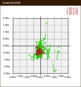
20 4 Oct /23 EGNOS-VRS performance example Beacon station: Mauken N E Far Field Monitor: Meißen 51 10' N E Baseline length: 76 km Availability Horizontal error Mean: 0.21 m 2σ: 0.26 m No. of satellites


21 4 Oct /23 EGNOS-VRS performance example Beacon station: Mauken N E Far Field Monitor: Meißen 51 10' N E Baseline length: 76 km Availability Horizontal error Mean: 0.21 m 2σ: 0.26 m No. of satellites Horizontal scatter

22 4 Oct /23 Radiobeacon signal quality monitoring Field strength Signal to Noise Ratio Data age

23 4 Oct /23 EGNOS-VRS advantages Reduction of onsite infrastructure Independence of correction generation (EGNOS) from integrity checking (responsibility of the maritime authority) IALA/IMO recommendation Quality of corrections not affected by local issues that could impact the beacon site (e.g. multipath, interference) Transparent for end users and compatible with deployed user equipment Transmission of EGNOS-VRS corrections via AIS #17 for IWW Generation of individual EGNOS-VRS corrections for each AIS base station location


24 4 Oct /23 GSA pilot project GSA/OP/07/13 SC24 Support to Maritime Service Providers for the transmission of EGNOS corrections via IALA beacons and AIS/VDES stations Objective: analyse the technical and economic feasibility of the transmission of EGNOS corrections via IALA beacons and AIS/VDES Different potential architectures will be analysed in the frame of dedicated pilot projects Advisory board: maritime and IWW authority experts to define the pilot projects Working groups: execute the pilot projects Project duration: 17 months (Phase1 + Phase2)

25 Thank you for your attention! Tamás Horváth Alberding GmbH Schmiedestraße 2 D Wildau Phone: Mobile: horvath@alberding.eu Web: Tamás Horváth 4 Oct /23
DGPS navigation service based on VRS with local EGNOS back-up
 DGPS navigation service based on VRS with local EGNOS back-up EGNOS SERVICE PROVISION WORKSHOP, Warsaw, 27-28 September 2016 Michael Hoppe German Federal Waterways and Shipping Administration Overview
EGNOS correction transmission via IALA beacons and AIS
 EGNOS correction transmission via IALA beacons and GSA SC24 pilot project results Tamás Horváth Alberding GmbH Danube Information Services Conference DISC 2018 12-13 December 2018, Bratislava, Slovakia
EGNOS/EDAS based solution for the French DGPS network. Author: Etienne LEROY
 EGNOS/EDAS based solution for the French DGPS network. Author: Etienne LEROY Date 04/10/2017 1.Context 2.EDAS Centralized based architecture 3.Software and devices 4.Test Campaign 5.Cost based analysis
Alberding solutions for GNSS infrastructure operators
 Tamás Horváth Alberding solutions for GNSS infrastructure operators 21.11.2017 1/35 Alberding solutions for GNSS infrastructure operators Tamás Horváth Alberding GmbH 4 th EUPOS Technical Meeting 21-22
Tamás Horváth. 06 June 2012
 Tamás Horváth Software solutions for GNSS infrastructure monitoring 06 June 2012 1/18 Software solutions for GNSS infrastructure monitoring Tamás Horváth Alberding GmbH 06 June 2012 Tamás Horváth Software
New Funding Opportunities to Support Safety of Navigation: EGNOS and Galileo
 New Funding Opportunities to Support Safety of Navigation: EGNOS and Galileo e-navigation Underway 31 January-2 February 2017 GSA 2016 The European GNSS Agency (GSA) today: Staff: about 145 Nationalities:
Canadian Coast Guard Review to Implement a Resilient Position, Navigation and Timing Solution for Canada. Mariners Workshop January 31 st, 2018
 Canadian Coast Guard Review to Implement a Resilient Position, Navigation and Timing Solution for Canada Mariners Workshop January 31 st, 2018 Outline Overview of GNSS use in the marine sector CCG Activities
IMO WORLDWIDE RADIONAVIGATION SYSTEM (WWRNS) Study on Communication Techniques for High Accuracy DGPS in the Republic of Korea
 Study on Communication Techniques for High Accuracy DGPS in the Republic of Korea") INTERNATIONAL MARITIME ORGANIZATION E IMO SUB-COMMITTEE ON SAFETY OF NAVIGATION 52nd session Agenda item 12 NAV 52/INF.8 12 May 2006 ENGLISH ONLY WORLDWIDE RADIONAVIGATION SYSTEM (WWRNS) Study on Communication
INTERNATIONAL MARITIME ORGANIZATION E IMO SUB-COMMITTEE ON SAFETY OF NAVIGATION 52nd session Agenda item 12 NAV 52/INF.8 12 May 2006 ENGLISH ONLY WORLDWIDE RADIONAVIGATION SYSTEM (WWRNS) Study on Communication
Market strategy update in Maritime segment. This presentation can be interpreted only together with the oral comments accompanying it
 Market strategy update in Maritime segment This presentation can be interpreted only together with the oral comments accompanying it 2 Market sub-segments and applications Recreational navigation: GNSS
EUPOS European Position Determination System
 EUPOS European Position Determination System c/o Senate Department for Urban Development, State Berlin, Germany Umea, Sweden, 22 nd 23 rd 2011 The Geodetic Infrastructure in Europe today and tomorrow Slide
IMO WORLD-WIDE RADIONAVIGATION SYSTEM (WWRNS) GALILEO receiver performance standards. Submitted by the European Commission
 GALILEO receiver performance standards. Submitted by the European Commission") INTERNATIONAL MARITIME ORGANIZATION E IMO SUB-COMMITTEE ON SAFETY OF NAVIGATION 50th session Agenda item 13 2 April 2004 Original: ENGLISH WORLD-WIDE RADIONAVIGATION SYSTEM (WWRNS) GALILEO receiver performance
INTERNATIONAL MARITIME ORGANIZATION E IMO SUB-COMMITTEE ON SAFETY OF NAVIGATION 50th session Agenda item 13 2 April 2004 Original: ENGLISH WORLD-WIDE RADIONAVIGATION SYSTEM (WWRNS) GALILEO receiver performance
COMMUNICATIONS FOR MARITIME SAFETY AND EFFICIENCY. Francis Zachariae, Secretary-General, IALA
 COMMUNICATIONS FOR MARITIME SAFETY AND EFFICIENCY Francis Zachariae, Secretary-General, IALA IALA and its Purpose Non profit, international technical association established in 1957 Two Goals aimed at
EUPOS - European Position Determination System Status and current issues
 EUPOS - European Position Determination System Status and current issues Office of the International EUPOS Steering Committee Senate Department for Urban Development, Land Berlin, Germany Symposium of
RIS in Germany. RIS week Berlin.
 RIS in Germany RIS week 2014 Berlin www.bmvi.de Main Waterways in Germany The German Waterway and Shipping Administration maintains 23,000 km² maritime waterways 7,300 km inland waterways 5,100 km main
A new Modular and Open Concept for the Maritime Integrated PNT System
 A new Modular and Open Concept for the Maritime Integrated PNT System T. Noack German Aerospace Center Institute of Communications and Navigation www.dlr.de Chart 2 MTS-2012 Maritime Integrated PNT Unit
Radio Navigation Aids Flight Test Seminar
 Radio Navigation Aids Flight Test Seminar FLIGHT INSPECTION IN THE NEW MILLENNIUM Curt Keedy FAA Flight Inspection Policy and Standards Change, Challenge, and Opportunity CHANGES Global Positioning system
European Radio Navigation Plan. Gilles LEQUEUX, European Commission Policy Development and Strategies
 European Radio Navigation Plan Gilles LEQUEUX, European Commission Policy Development and Strategies CONTEXT - BENEFITS Space Strategy for Europe Introduction of EGNSS in EU sectoral policies Better strategic
European Position Determination System. Technical Standards
 European Position Determination System Technical Standards Revised 2 nd Edition 24 April 2008 Resolution of the International EUPOS Steering Committee 13 th Conference, Bucharest, Romania, 23 24 April
EUPOS: Unified GNSS Augmentation Infrastructure and International Cooperation in Central and Eastern Europe
 EUPOS: Unified GNSS Augmentation Infrastructure and International Cooperation in Central and Eastern Europe Senate Department for Urban Development Geodetic Reference Systems Fehrbelliner Platz 1, 10707
The Future for the AIS AtoN. Michael Card Zeni Lite Buoy Co., Ltd., Japan
 The Future for the AIS AtoN Michael Card Zeni Lite Buoy Co., Ltd., Japan History Early work in USA and Europe Not compatible with UAIS First UAIS AIS AtoN was Akari-400 Launched at IALA Sydney, 8 years
GNSS MONITORING NETWORKS
 SPACE GNSS MONITORING NETWORKS Satellite communications, earth observation, navigation and positioning and control stations indracompany.com GNSS MONITORING NETWORKS GNSS MONITORING NETWORKS Indra s solutions
Monitoring with low-cost GNSS receivers
 Monitoring with low-cost GNSS receivers GNSS monitoring with low-cost receivers 1 Why GNSS? Your advantages! free of charge and available worldwide No line of sight connection is necessary to the measuring
Exploiting the high precision capabilities of the Hellenic Positioning System - HEPOS
 Exploiting the high precision capabilities of the Hellenic Positioning System - HEPOS M. Gianniou, D. Mastoris, I. Stavropoulou Geodetic Department KTIMATOLOGIO S.A. 339 Mesogion Ave., 15562 Holargos Greece
GSA GNSS Technology Report Main highlights IPIN 2018
 GSA GNSS Technology Report Main highlights IPIN 2018 Justyna Redelkiewicz, European GNSS Agency 25 September 2018, Nantes The European GNSS Agency (GSA) is responsible for market development and operations
GALILEO Research and Development Activities. Second Call. Area 1A. Statement of Work
 GALILEO Research and Development Activities Second Call Area 1A GNSS Introduction in the Maritime Sector Statement of Work Rue du Luxembourg, 3 B 1000 Brussels Tel +32 2 507 80 00 Fax +32 2 507 80 01 www.galileoju.com
Future Generation of AIS Considers Integration of AIS and VDE. TEXAS V Workshop Canadian Embassy, Washington DC 7-8 November 2012
 Future Generation of AIS Considers Integration of AIS and VDE TEXAS V Workshop Canadian Embassy, Washington DC 7-8 November 2012 1 Rationale for the Integration of AIS and VDE (VHF Data Exchange) Protects
European GNSS Applications in H2020
 European GNSS Applications in H2020 Countdown to H2020 12.12.2013, Brussels Carmen Aguilera European GNSS Agency Agenda European GNSS Agency EU-GNSS market potential FP7- experience and results H2020 opportunities
GBAS-Technologies for High Precise Safety-Critical Maritime Navigation
 GBAS-Technologies for High Precise Safety-Critical Maritime Navigation S. Schlüter, E. Engler, T. Noack, J. Beckheinrich, A. Hirrle, C. Becker, D. Klähn Abstract As a result of the high quality of positioning
Protection Augmentation Toughness and Alternatives of GNSS. Melaha 2016 Concord Al-Salam Hotel Cairo, April 25,2016 Refaat Rashad
 Protection Augmentation Toughness and Alternatives of GNSS Melaha 2016 Concord Al-Salam Hotel Cairo, April 25,2016 Refaat Rashad Road Map of the Presentation 1- How Good are GNSS 2- How Vulnerable are
GNSS Programme. Overview and Status in Europe
 GNSS Programme Overview and Status in Europe Inaugural Forum Satellite Positioning Research and Application Center 23 April 2007 Tokyo Presented by Thomas Naecke (European Commission) Prepared by Daniel
GEURIW project- use of EGNOS for inland waterways navigation
 DANUBE INFORMATION SERVICES CONFERENCE- DISC 2016 Regenburg, Germany 6-7 th of December 2016 GEURIW project- use of EGNOS for inland waterways navigation Alina Radutu- Romanian Space Agency romanian space
SSR Technology for Scalable Real-Time GNSS Applications
 SSR Technology for Scalable Real-Time GNSS Applications Gerhard Wübbena, Jannes Wübbena, Temmo Wübbena, Martin Schmitz Geo++ GmbH 30827 Garbsen, Germany www.geopp.de Abstract SSR Technology for scalable
GUIDELINES ON THE DESIGN AND USE OF PORTABLE PILOT UNITS INTERNATIONAL MARITIME PILOTS ASSOCIATION
 GUIDELINES ON THE DESIGN AND USE OF PORTABLE PILOT UNITS INTERNATIONAL MARITIME PILOTS ASSOCIATION WITH TECHNICAL INPUT FROM Comité International Radio-Maritime (CIRM) 2 FOREWORD With the increasing use
RECOMMENDATION ITU-R M *
 Rec. ITU-R M.823-3 1 RECOMMENDATION ITU-R M.823-3 * Technical characteristics of differential transmissions for global navigation satellite systems from maritime radio beacons in the frequency band 283.5-315
JCG GMDSS Symposium NAVDAT : Navigational Data
 JCG GMDSS Symposium 2013 NAVDAT : Navigational Data - System Presentation - Pascal OLIVIER NAVDAT Presentation Page 1/35 From analog to digital in maritime radio communications The current analog radio
GNSS High Precision Systems for Cadastre: development, experiences and Galileo perspectives
 GNSS High Precision Systems for Cadastre: development, experiences and Galileo perspectives CLGE Plenary Workshop 29 September 2017 Roberto Capua, Flavio Ferrante DO-11-DO-03 1 Agenda GNSS High Precision
Initial Results of MF-DGNSS R-Mode as an Alternative Position Navigation and Timing Service
 University of Rhode Island DigitalCommons@URI Department of Electrical, Computer, and Biomedical Engineering Faculty Publications Department of Electrical, Computer, and Biomedical Engineering 2017 Initial
AN AUSTRALIAN PILOT PROJECT FOR A REAL TIME KINEMATIC GPS NETWORK USING THE VIRTUAL REFERENCE STATION CONCEPT
 AN AUSTRALIAN PILOT PROJECT FOR A REAL TIME KINEMATIC GPS NETWORK USING THE VIRTUAL REFERENCE STATION CONCEPT Matthew B HIGGINS, Australia Key words: GPS, Surveying, Real Time Kinematic, Virtual Reference
Towards a EUREF Service Providing Real-time GNSS Clock and Orbit Corrections
 Towards a EUREF Service Providing Real-time GNSS Clock and Orbit Corrections G. Weber 1), W. Söhne 1), A. Stürze 1), L. Mervart 2) 1) Federal Agency for Cartography and Geodesy, Frankfurt am Main, Germany
Overview of the global GNSS market and status of Galileo
 2012 GNSS.asia workshop Overview of the global GNSS market and status of Galileo 6 November, 2012 Taipei Justyna Redelkiewicz, European GNSS Agency European GNNS Agency supports European Commission in
ORBITAL NAVIGATION SYSTEMS PRESENT AND FUTURE TENDS
 ORBITAL NAVIGATION SYSTEMS PRESENT AND FUTURE TENDS CONTENT WHAT IS COVERED A BRIEF HISTORY OF SYSTEMS PRESENT SYSTEMS IN USE PROBLEMS WITH SATELLITE SYSTEMS PLANNED IMPROVEMENTS CONCLUSION CONTENT WHAT
PORTABLE GNSS MONITORING STATION (PGMS)
") SPACE PORTABLE GNSS MONITORING STATION (PGMS) Satellite communications, earth observation, navigation and positioning and control stations indracompany.com PORTABLE GNSS MONITORING STATION (PGMS) PORTABLE
SPACE PORTABLE GNSS MONITORING STATION (PGMS) Satellite communications, earth observation, navigation and positioning and control stations indracompany.com PORTABLE GNSS MONITORING STATION (PGMS) PORTABLE
SSR & RTCM Current Status
 SSR & RTCM Current Status Gerhard Wübbena, Martin Schmitz, Jannes Wübbena Geo++ GmbH 30827 Garbsen, Germany www.geopp.de Outline RTCM SC104 WG s SSR Today SSR Formats SC104 RTCM-SSR Geo++ RTCM 4090 SSR
Emerging Digital Radio Services
 Emerging Digital Radio Services Report to RTCM 2011 Annual Meeting from RTCM Special Committee 123 Ross Norsworthy, RTCM SC123 Chairman 1 Emerging Digital Radio Services 1. VHF data exchange a) RTCM SC123
ICG 9 PRAGUE 10 November 2014
 ICG 9 PRAGUE 10 November 2014 GNSS and applications GNSS is technology powerfully enabler of a multitude of applications. Italy, recognizing that, have undertaken initiatives to develop pre-operational
GMDSS modernisation and e-navigation: spectrum needs
 ETSI Workshop "Future Evolution of Marine Communication", 7-8 November 2017, Sophia Antipolis, France GMDSS modernisation and e-navigation: spectrum needs Karlis Bogens BR Terrestrial Services Department
JOURNAL OF MARITIME RESEARCH. The Architecture of Data Transmission in Inland Navigation
 JOURNAL OF MARITIME RESEARCH Vol XI. No. II (2014) pp 3 7 ISSN: 1697-4040, www.jmr.unican.es The Architecture of Data Transmission in Inland Navigation A. Lisaj 1,2, and P. Majzner 3 ARTICLE INFO Article
Dimov Stojče Ilčev. CNS Systems
 Stratospheric Platform Systems (SPS) Presentation by: Dimov Stojče Ilčev Durban University of Technology (DUT) Space Science Centre (SSC) CNS Systems August 2011 SPS for Mobile CNS Applications Stratospheric
European Position Determination System (EUPOS )
") European Position Determination System (EUPOS ) Georgi MILEV, Bulgaria, Gerd ROSENTHAL, Germany and Keranka VASSILEVA, Bulgaria Key words: ABSTRACT The project EUPOS is an initiative to establish a uniform
European Position Determination System (EUPOS ) Georgi MILEV, Bulgaria, Gerd ROSENTHAL, Germany and Keranka VASSILEVA, Bulgaria Key words: ABSTRACT The project EUPOS is an initiative to establish a uniform
Global and Regional Real-Time Infrastructure for open access use
 Global and Regional Real-Time Infrastructure for open access use Axel Rülke Federal Agency for Cartography and Geodesy Branch Office Leipzig, Germany Tutorial on (Open) Real-Time Infrastructure and Applications
VHF Data Exchange System (VDES)
") VHF Data Exchange System (VDES) ETSI Workshop Future Evolution of Marine Communication 7-8 November 2017 Malcolm Lyman Marketing Manager CML Microcircuits UK With acknowledgments to the members of IALA
VHF Data Exchange System (VDES) ETSI Workshop Future Evolution of Marine Communication 7-8 November 2017 Malcolm Lyman Marketing Manager CML Microcircuits UK With acknowledgments to the members of IALA
A new radio system for the German coast Innovative applications for conventional VHF
 16, 18, 79, HK 16, 20, 21, 15 Channel 16, 70, 80, HK 16, 20, 63 22 2, 4, 7 19, 63, 73 15, 16 5, 18, 19, 71 21, 82 16, 5, 16, HK, 78 15, 16, HK 6, 8, 10, 12, 21, 74, 81 2, 9, 13,16, 18, 62, 67, 68, HK,
Resilient PNT: From PNT-Unit concept to first realization
 www.dlr.de Chart 1 >Resilient PNT: From PNT Unit concept to first realization> R. Ziebold > e-navigation Underway 1/3/213 Resilient PNT: From PNT-Unit concept to first realization Ralf Ziebold, Z. Dai,
Cross-Border EUPOS Data Exchange First Experience
 Cross-Border EUPOS Data Exchange First Experience Eimuntas Paršeliūnas, Marius Petniūnas, Domantas Bručas (Institute of Geodesy of Vilnius Gediminas Technical University, Lithuania) Wieslaw Graszka (Head
Leica Spider Infrastructure HW Solutions Introducing: Leica GR30 & GR50
 Leica Spider Infrastructure HW Solutions Introducing: Leica GR30 & GR50 Reliable solutions for today and tomorrow Leica Spider Integrated Solutions Introducing: Leica GR30 & GR50 Outline Introducing Leica
GNSS Training for ITS Developers. Characterisation of EGNSS performances in relationship with the application requirements
 GNSS Training for ITS Developers Characterisation of EGNSS performances in relationship with the application requirements Table of Content egnss for Application: Main Challenges EGNOS and GALILEO Performances
Maritime Electronics Supporting Unmanned Vessels
 EU-Japan Policy Workshop Maritime Electronics Supporting Unmanned Vessels November 11 th, 2016 TAKUO KASHIWA, Ph.D Furuno Electric Co., Ltd. Agenda Positioning Technologies for Vessel s position Technologies
Future Concepts for Galileo SAR & Ground Segment. Executive summary
 Future Concepts for Galileo SAR & Ground Segment TABLE OF CONTENT GALILEO CONTRIBUTION TO THE COSPAS/SARSAT MEOSAR SYSTEM... 3 OBJECTIVES OF THE STUDY... 3 ADDED VALUE OF SAR PROCESSING ON-BOARD G2G SATELLITES...
SKPOS. Slovak real-time positioning service - a multifunctional tool for precise object and phenomena positioning
 SKPOS Slovak real-time positioning service - a multifunctional tool for precise object and phenomena positioning WHAT IS SKPOS AND HOW DOES IT WORK? Slovak real-time positioning service is a multifunctional
Brief installation guide for FA-100 Universal AIS
 Attention: All Furuno Distributors Date: April 2, 2003 SB No: FSB02-0002 Number of Pages: 5 Brief installation guide for FA-100 Universal AIS The purpose of this document is to provide and highlight important
ETSI Workshop "Future Evolution of Marine Communication Radar evolution for inland waterways navigation Mario Walterfang
 Mario Walterfang Fachstelle der WSV für Verkehrstechniken (FVT) Federal German Waterways and Shipping Administration Sophia Antipolis, France, November 7th, 2017 Overview Milestones in river radar evolution
RELEASE NOTES. Introduction. Trimble Infrastructure GNSS Series Receivers
 RELEASE NOTES Trimble Infrastructure GNSS Series Receivers These release notes describe the latest improvements made to the Trimble NetR9 GNSS Infrastructure series receivers. Introduction New Features
Technical Details and Guidelines for VDES Implementation
 Technical Details and Guidelines for VDES Implementation 2 nd Workshop on VDES Tokyo, Japan 20-24 January 2014 By: Ross Norsworthy Contributions from: Stefan Bober, IALA e-nav Committee 1 Data transmission
Latest Developments in Network RTK Modeling to Support GNSS Modernization
 Journal of Global Positioning Systems (2007) Vol.6, No.1: 47-55 Latest Developments in Network RTK Modeling to Support GNSS Modernization Herbert Landau, Xiaoming Chen, Adrian Kipka, Ulrich Vollath Trimble
The EU Satellite Navigation programmes status Applications for the CAP
 The EU Satellite Navigation programmes status Applications for the CAP Michaël MASTIER European Commission DG ENTR GP3 GNSS Applications, Security and International aspects GPS Workshop 2010 Montpellier
European GNSS Evolution
 Ref. Ares(204)902599 - /06/204 European GNSS Evolution Hermann Ebner Galileo and EGNOS Programme Management DG Enterprise and Industry Content Introduction 2 2 Major Challenges for EGNSS Evolution 3 EGNSS
GBAS FOR ATCO. June 2017
 GBAS FOR ATCO June 2017 Disclaimer This presentation is for information purposes only. It should not be relied on as the sole source of information, and should always be used in the context of other authoritative
VERY PRECISE SYNCHRONIZATION OF A GROUP OF PSEUDOLITES
 VERY PRECISE SYNCHRONIZATION OF A GROUP OF PSEUDOLITES Werner R. Lange Lange-Electronic GmbH Gernlinden, Germany T.: +49-8142-2845820 WLange@lange-electronic.de Abstract Pseudolites are GNSS transmitters
Working Party 5B DRAFT NEW RECOMMENDATION ITU-R M.[500KHZ]
![Working Party 5B DRAFT NEW RECOMMENDATION ITU-R M.[500KHZ]](/thumbs/92/109768647.jpg "Working Party 5B DRAFT NEW RECOMMENDATION ITU-R M.[500KHZ]") Radiocommunication Study Groups Source: Subject: Document 5B/TEMP/376 Draft new Recommendation ITU-R M.[500kHz] Document 17 November 2011 English only Working Party 5B DRAFT NEW RECOMMENDATION ITU-R M.[500KHZ]
Radiocommunication Study Groups Source: Subject: Document 5B/TEMP/376 Draft new Recommendation ITU-R M.[500kHz] Document 17 November 2011 English only Working Party 5B DRAFT NEW RECOMMENDATION ITU-R M.[500KHZ]
MAGICGNSS RTCM-BASED SERVICE, A LEAP FORWARD TOWARDS MULTI- GNSS HIGH ACCURACY REAL-TIME PROCESSING
 ION GNSS 2015 MAGICGNSS RTCM-BASED SERVICE, A LEAP FORWARD TOWARDS MULTI- GNSS HIGH ACCURACY REAL-TIME PROCESSING SEPTEMBER 16 TH, 2015 - ION GNSS 2015, TAMPA, FLORIDA, USA SESSION E2A: NEXT GENERATION
Experiences with Fugro's Real Time GPS/GLONASS Orbit/Clock Decimeter Level Precise Positioning System
 Return to Session Directory DYNAMIC POSITIONING CONFERENCE October 13-14, 2009 Sensors Experiences with Fugro's Real Time GPS/GLONASS Orbit/Clock Decimeter Level Precise Positioning System Ole Ørpen and
The Loran-C Resource in China and Its Potential Applications
 The Loran-C Resource in China and Its Potential Applications WU Haitao BIAN Yujing LI Zhigang Shaanxi Astronomical Observatory, The Chinese Academy of Sciences, P.O.Box 18,Lintong Shaanxi, China, 710600
GNSS in the Arctic. by Arne Rinnan, Kongsberg Seatex AS. WORLD CLASS through people, technology and dedication
 GNSS in the Arctic by Arne Rinnan, Kongsberg Seatex AS WORLD CLASS through people, technology and dedication Outline Introduction Weather conditions Satellite coverage Aurora impact GNSS corrections Test
Report on EGNOS application as effective augmentation system for marine positioning in inland and pilot navigation. Submitted by Germany and Poland *
 E SUB-COMMITTEE ON NAVIGATION, COMMUNICATIONS AND SEARCH AND RESCUE 4th session Agenda item 6 NCSR 4/INF.16/Rev.2 28 February 2017 ENGLISH ONLY GUIDELINES ASSOCIATED WITH MULTI-SYSTEM SHIPBORNE RADIONAVIGATION
METIS Second Master Training & Seminar. Augmentation Systems Available in Egypt
 METIS Second Master Training & Seminar Augmentation Systems Available in Egypt By Eng. Ramadan Salem M. Sc. Surveying and Geodesy Email: ramadan_salem@link.net Page 1 Augmentation Systems Available in
Recommendations on Differential GNSS
 Recommendations on Differential GNSS Mr. Joseph W. Spalding USCG Research & Development Center Dr. Jacques Beser S Navigation Inc. Dr. Frank van Diggelen Ashtech, Inc. BIOGRAPHY Mr. Joseph Spalding is
GNSS in Maritime and Education in Egypt
 GNSS in Maritime and Education in Egypt GNSS IN MARITIME PORTS SHIPS PORTS WATERWAYS GNSS maritime applications will help to improve: navigation. Ship operations. Traffic management. Seaport operations.
Maritime Geo-Fence Letter Report
 Report No. CG-D-10-16 Maritime Geo-Fence Letter Report Authors: Irene Gonin and Gregory Johnson Distribution Statement A: Approved for public release; distribution is unlimited. July 2016 Classification
GALILEO AND EGNOS VALUE PROPOSITION FOR E112
 Ref. Ares(2014)1665692-22/05/2014 GALILEO AND EGNOS VALUE PROPOSITION FOR E112 Fiammetta Diani, Justyna REDELKIEWICZ European GNSS Agency (GSA) Brussels, 07/05/2014 Agenda European GNSS Agency at a glance
GLONASS Status and Modernization
 GLONASS Status and Modernization Ekaterina Oleynik Central Research Institute of Roscosmos Federal Space Agency United Nations/Latvia Workshop on the Applications of Global Navigation Satellite Systems
CH GPS/GLONASS/GALILEO/SBAS Signal Simulator. General specification Version 0.2 Eng. Preliminary
 CH-380 GPS/GLONASS/GALILEO/SBAS Signal Simulator General specification Version 0.2 Eng Preliminary Phone: +7 495 665 648 Fax: +7 495 665 649 navis@navis.ru NAVIS-UKRAINE Mazura str. 4 Smela, Cherkassy
EGNOS status and performance in the context of marine navigation requirements
 EGNOS status and performance in the context of marine navigation requirements J. Cydejko Gdynia Maritime University, Gdynia, Poland ABSTRACT: The current status of EGNOS (December 2006) is described as
National Report of Greece to EUREF 2009
 National Report of Greece to EUREF 2009 M. Gianniou KTIMATOLOGIO S.A. (Hellenic Cadastre) 1 Introduction In 2007, KTIMATOLOGIO S.A (Hellenic Cadastre) established HEPOS, the HEllenic POsitioning System,
ESA/CNES/ARIANESPACE-Service Optique CSG, S. Martin ABUJA, OCTOBER 2018
 ESA/CNES/ARIANESPACE-Service Optique CSG, S. Martin ABUJA, OCTOBER 2018 GALILEO - SOME KEY FEATURES CIVIL Not managed by Defence DUAL FREQUENCY (L1/L5 ) Less impact from solar conditions/ionosphere DIGITAL
GNSS VULNERABILITY AND CRITICAL INFRASTRUCTURE
 GNSS VULNERABILITY AND CRITICAL INFRASTRUCTURE NNF CONFERENCE 24 MAY 2012 Brynjar Hansen Senior adviser Norwegian Space Centre Lars Giske Senior adviser Norwegian Space Centre MULTI GNSS EXTERNAL COOPERATION
Challenges and Solutions for GPS Receiver Test
 Challenges and Solutions for GPS Receiver Test Presenter: Mirin Lew January 28, 2010 Agenda GPS technology concepts GPS and GNSS overview Assisted GPS (A-GPS) Basic tests required for GPS receiver verification
EUPOS the success guarantee for rapid buildup the infrastructure in the countries of Central and Eastern Europe
 EUPOS the success guarantee for rapid buildup the infrastructure in the countries of Central and Eastern Europe Dr. Ivo Milev Representative of the International EUPOS Steering Committee Contact: Dr. Ivo
Photo: HERO/Nordlicht
 Research Port Rostock - Network for Maritime Applications Photo: HERO/Nordlicht Structure t Who we are What we do What we want Video nereus Brussels 2 Structure t Who we are What we do What we want Video
Loran C in Europe. 34 th Annual ILA Convention and Technical Symposium October 2005 Santa Barbara
 34 th Annual ILA Convention and Technical Symposium 17-19 October 2005 Santa Barbara Loran C in Europe Jacques MANCHARD Head of the Maritime Ads to Navigation Division (Phares et Balises) Ministry of Transport,
Trimble NetR9 Reference Receiver Series: Frequently Asked Questions
 July 2010 Trimble NetR9 Reference Receiver Series: Frequently Asked Questions What is the Trimble NetR9 GNSS reference receiver? The Trimble NetR9 GNSS (Global Navigation Satellite System) reference receiver
02 Issue. e-navigation News. GNSS Vulnerability. Dublin Bay Digital Diamond. e-navigation. Demonstrator Update International. e-navigation.
 CORPORATE SECURITY TEAMWORK EVENTS 02 Issue e-navigation News GNSS Vulnerability Dublin Bay Digital Diamond e-navigation Demonstrator Update International e-navigation update June 2014 www.cil.ie +353
Report on Maritime and Inland Waterways User Needs and Requirements Outcome of the European GNSS User Consultation Platform
 Report on Maritime and Inland Waterways User Needs and Requirements Outcome of the European GNSS User Consultation Platform Reference: GSA-MKD-MAR-UREQ-229399 Issue/Revision: 1.0 Date: 18/10/2018 Change
al T TD ) ime D Faamily Products The RTD Family of products offers a full suite of highprecision GPS sensor positioning and navigation solutions for:
 ime D Faamily Products The RTD Family of products offers a full suite of highprecision GPS sensor positioning and navigation solutions for:") Reeal ynnamics al T amics (R TD ) ime D RTD) Time Dy Faamily mily ooff P roducts Products The RTD Family of products offers a full suite of highprecision GPS sensor positioning and navigation solutions
Reeal ynnamics al T amics (R TD ) ime D RTD) Time Dy Faamily mily ooff P roducts Products The RTD Family of products offers a full suite of highprecision GPS sensor positioning and navigation solutions
METIS & MEDIGATE Conference Tunis - Tunisia
 MEdiTerranean Introduction of GNSS (Global Satellite Navigation System) Services METIS & MEDIGATE Conference Tunis - Tunisia Telespazio S.p.A. Antonella Di Fazio email: antonella.difazio@telespazio.com
EUPOS Central and Eastern European Differential (D)GNSS Infrastructure, and Cooperation
GNSS Infrastructure, and Cooperation") EUPOS Central and Eastern European Differential (D)GNSS Infrastructure, and Cooperation Office of the International EUPOS Steering Committee, Head Senate Department for Urban Development, State of Berlin,
EUPOS Central and Eastern European Differential (D)GNSS Infrastructure, and Cooperation Office of the International EUPOS Steering Committee, Head Senate Department for Urban Development, State of Berlin,
GALILEO READY TO LINK WITH INSPIRE
 GALILEO READY TO LINK WITH INSPIRE INSPIRE CONFERENCE 2016 Barcelona 28 September 2016 Alina Hriscu Market Development European GNSS Agency (GSA) Agenda European GNSS Agency (GSA) E GNSS Services, Signals
UPDATE ON EGNOS AND GALILEO
 UPDATE ON EGNOS AND GALILEO Riga CLGE GA 23 September 2016 Alina Hriscu Market Development European GNSS Agency (GSA) This presentation can be interpreted only together with the oral comments accompanying
Galileo. 7th ITFS, Rome, Italy, 3-5 November Dr. Stefan Bedrich. Kayser-Threde GmbH Wolfratshauser Str Munich
 Kayser-Threde GmbH Wolfratshauser Str. 48 81379 Munich spacetech@kayser-threde.com Galileo 7th ITFS, Rome, Italy, 3-5 November 2009 Dr. Stefan Bedrich w w w. k a y s e r - t h r e d e. c o m Outline Motivation
Galileo & EGNOS Programmes Status
 Galileo & EGNOS Programmes Status Ugo Celestino, European Commission EURO-MEDITERRANEAN TRANSPORT FORUM GNSS WORKING GROUP 16 th October 2012 17 October, 2012 The European GNSS Programmes 2 Table of contents