Stations and Datum Transformation
|
|
|
- Susan Wheeler
- 5 years ago
- Views:
Transcription
1 Continuously Operating Referene Stations and Datum Transformation (CORS-TR) Ali Kılıçoğlu Geodesy Department, GCM Turkey EUREF 2009, May 2009, Firenze, Italy
2 147 CORS 2 Control Centers 7/24 RTK service Datum Transformation Surveying and mappin Cadstral works Geographical Information Systems Land registry e-goverment
3 Granted by Turkish National Research Council (TÜBİTAK) Customers General Command of Mapping General Directorate t of Land Register and Cadastre Implementing Institute Istanbul Culture University it
4 CORS-TR Stations Existing permanent st. (27) CORS_TR st. (147)
5 CORS-TR STATIONS geological basement characteristics, stability, electricity, internet connection and security issues Mainly in Meteorological Stations, Universities, Municipalities, Other govermental buildings and fields.


6 CORS-TR ROOF TYPE PILLAR
7 CORS-TR GROUND TYPE PILLAR
8 KONYA Permanent GPS Station


9 DGPS/RTK NETWORK STRUCTURE GNSS Satellite Comm. Satellite GNSS Satellite Control Center 2 RTCM, CMR+ 4 3 CORS-TR station 2 NMEA Users GPRS
10 CORS-TR Control Center RTK Corrections will be computed and send to users in real time. Additionally, 30 second GNSS data Additionally, 30 second GNSS data will be stored for post-processing and will be available for users via internet.


11 CORS-TR Station ti
12 Networked Transport of RTCM via Internet Protocol will be used. DGPS/RTK Gezici Alıcı RS232 NTRIP Client HTTP HTTP NTRIP Server.. GPRS BlueTooth NTRIP CASTER COM port.. Referans Alıcısı DGPS/RTK Gezici Alıcı NTRIP Client HTTP HTTP ADSL / GPRS NTRIP Server Referans Alıcısı NTRIP, http based general and independent protocol, has been developed by BKG/Germany so as to broadcast differential corrections and other types of GNSS information to users via internet.
13 Edirne Kirklareli CLASSICAL DGPS/RTK SARAY Single stations and covering area (5, 7.5 and 10 km radius) Catalca Tekirdag Istanbul KESAN Canakkale kilometers Accuracy, Reliability, Availability good bad
14 NETWORK DGPS/RTK Edirne Kirklareli Network stations and covering area SARAY (40 and 50 km radius) Catalca Tekirdag Istanbul KESAN Canakkale kilometers Accuracy, Reliability, Availability good bad
15 CORS-TR DGPS/RTK NETWORK Interstation distances; mean 80 km, maximum 100 km.
16 PROCESSING OF CORS-TR GPS DATA Exisitng Permanant stations (tusa) 1st Group CORS-TR st. (tus1) 2nd Group CORS-TR st. (tus2) 3rd Group CORS-TR st. (tus3) 4th Group CORS-TR st. (tus4)
17 CORS-TR DATA PROCESSING ERP Bulletin B Global solution files higs1a.* higs2a* higs3a* Station data (daily) TUSAGA CORS-TR IGS IGS Final orbit GAMIT Soluton files htusaa.* htus1a.* htus2a.* htus3a.* higs4a* higs5a.* GLRED Time series Monthly combinations GLOBK GLRED Time series Coordinates and velocities (ITRF2005) GLOBK htus4a.* İn case gross eroors in case gross errors GLORG velocities (EUREF)
18 Regional IGS Stations used in the data processing
19 Global IGS Stations used in the data processing


20 Long term time series of exisiting permanent stations
21 Long term time series analysis
22 (Short term) Time series of COSR-TR stations
23 For an accurate velocity Estimation (> 2.5 year); East component : MATE ONSA WTZR GRAZ VILL TRAB ANKR ISTA AKHI North Component : MATE ONSA WTZR GRAZ VILL TRAB ANKR ISTA AKHI Up Component : MATE ONSA WTZR GRAZ VILL TRAB ANKR ISTA AKHI
24 Determination of CORS-TR station coordinates in TUREF
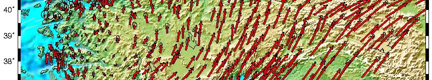
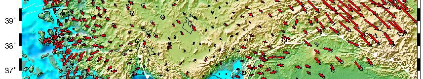
25 CORS-TR Horizontal Velocity Field wrt Eurasia (short term)


26 GPS meteorology Preceptable Water Vapor (PW)
27 28 Comparison (PW/GPS and PW/Radiosonde) 20/04/..yağış yok. 21/04/ <0.1 kg 22/04/ kg /04/ < 0.1 kg 22/04/ kg 22/04/ kg. 23/04/ kg /04/ kg 23/04/ kg 24/04/.. No rain. 16 Radiosonde_PW 12 8 GPS_PW April 2005


28 6 and 12 hour rain forecasts 25 Oct 00:00-25 Oct 06:00 25 Oct 00:00-26 Oct 00:00 Rain 26 Oct 12:00 18:00 at maximum level.
29 Datum transformation works (ED50/WGS84) Planned GPS obs. ~3000 stations
30 CORS-TR has been operational since May At the moment, corrections are provided in RTCM/CMR+ format via GPRS/EDGE and single frequency receivers (for DGPS) and dual frequency receivers (for RTK) with GPRS modems are able to receive corrections.


31 Rover GPS Receivers : Should be dual frequency, be able to receive carrier phase corrections (RTCM/CMR) and be able to solve ambiguity with its own software.


32 NNRT ANATOLIA EURASIA ARABIA
33 ETRS-89 vs TUREF Coor. Diff. Caused by Anatolian velocity wrt Eurasia East comp. (mm) ETRS-89 vs TUREF North Comp (mm)
34 Thanks for your attention.
Setting up i80 CHC receiver in RTK mode using TcpGPS
 Sumatra, 9 E-29190 Málaga (Spain) www.aplitop.com Phone: +34 952439771 Fax: +34 952431371 Technical Note (tcpgps_en_v41_002_setting_up_chc_i80_in_rtk_mode) Setting up i80 CHC receiver in RTK mode using
SERVIR: The Portuguese Army CORS Network for RTK
 SERVIR: The Portuguese Army CORS Network for RTK António Jaime Gago AFONSO, Rui Francisco da Silva TEODORO and Virgílio Brito MENDES, Portugal Key words: GNSS, RTK, VRS, Network ABSTRACT Traditionally
NTRIP Background History, Development & BKG. Networked Transport of RTCM via Internet Protocol
 Networked Transport of RTCM via Internet Protocol Networked Transport of RTCM via Internet Protocol Bundesamt für Kartographie und Geodäsie Motivation: Use Internet to transport GNSS corrections Communication
Cors Networks And Investigation Of Point Positioning Accuracy Of Konya Permanent GNSS Network (Kosaga)
") Cors Networks And Investigation Of Point Positioning Accuracy Of Konya Permanent GNSS Network (Kosaga) Ayhan CEYLAN, Turkey Key words: GNSS, Cors-Tr, Kosaga SUMMARY Mankind has always wondered where it
Cors Networks And Investigation Of Point Positioning Accuracy Of Konya Permanent GNSS Network (Kosaga) Ayhan CEYLAN, Turkey Key words: GNSS, Cors-Tr, Kosaga SUMMARY Mankind has always wondered where it
CORS NETWORKS AND INVESTIGATION OF POINT POSITIONING ACCURACY OF KONYA PERMANENT GNSS NETWORK (KOSAGA)
") Presented at the FIG Congress 2018, May 6-11, 2018 in Istanbul, Turkey CORS NETWORKS AND INVESTIGATION OF POINT POSITIONING ACCURACY OF KONYA PERMANENT GNSS NETWORK (KOSAGA) Ayhan CEYLAN Selcuk University
Presented at the FIG Congress 2018, May 6-11, 2018 in Istanbul, Turkey CORS NETWORKS AND INVESTIGATION OF POINT POSITIONING ACCURACY OF KONYA PERMANENT GNSS NETWORK (KOSAGA) Ayhan CEYLAN Selcuk University
IMO WORLDWIDE RADIONAVIGATION SYSTEM (WWRNS) Study on Communication Techniques for High Accuracy DGPS in the Republic of Korea
 Study on Communication Techniques for High Accuracy DGPS in the Republic of Korea") INTERNATIONAL MARITIME ORGANIZATION E IMO SUB-COMMITTEE ON SAFETY OF NAVIGATION 52nd session Agenda item 12 NAV 52/INF.8 12 May 2006 ENGLISH ONLY WORLDWIDE RADIONAVIGATION SYSTEM (WWRNS) Study on Communication
INTERNATIONAL MARITIME ORGANIZATION E IMO SUB-COMMITTEE ON SAFETY OF NAVIGATION 52nd session Agenda item 12 NAV 52/INF.8 12 May 2006 ENGLISH ONLY WORLDWIDE RADIONAVIGATION SYSTEM (WWRNS) Study on Communication
Tamás Horváth. 06 June 2012
 Tamás Horváth Software solutions for GNSS infrastructure monitoring 06 June 2012 1/18 Software solutions for GNSS infrastructure monitoring Tamás Horváth Alberding GmbH 06 June 2012 Tamás Horváth Software
FIELD TEST OF THE GPS+GLONASS RTK AT THE CAGLIARI PERMANENT STATION VIA INTERNET. Giannina Sanna, Giuseppina Vacca
 FIELD TEST OF THE GPS+GLONASS RTK AT THE CAGLIARI PERMANENT STATION VIA INTERNET Giannina Sanna, Giuseppina Vacca University of Cagliari Department of Structural Engineering P.zza D Armi 913 Cagliari,
National Report of Greece to EUREF 2010
 National Report of Greece to EUREF 2010 M. Gianniou KTIMATOLOGIO S.A. (Hellenic Cadastre) 1 Introduction The HEllenic POsitioning System (HEPOS) is an RTK network consisting of 98 reference stations that
Trimble NetR9 Reference Receiver Series: Frequently Asked Questions
 July 2010 Trimble NetR9 Reference Receiver Series: Frequently Asked Questions What is the Trimble NetR9 GNSS reference receiver? The Trimble NetR9 GNSS (Global Navigation Satellite System) reference receiver
Towards a EUREF Service Providing Real-time GNSS Clock and Orbit Corrections
 Towards a EUREF Service Providing Real-time GNSS Clock and Orbit Corrections G. Weber 1), W. Söhne 1), A. Stürze 1), L. Mervart 2) 1) Federal Agency for Cartography and Geodesy, Frankfurt am Main, Germany
Leica GRX1200+ Series High Performance GNSS Reference Receivers
 Leica GRX1200+ Series High Performance GNSS Reference Receivers Leica GRX1200+ Series For permanent reference stations The Leica GRX1200+ Series, part of Leica's future proof System 1200, is designed specifically
BENCHMARK TEST THE ESTABLISHMENT OF CORS TR & DATUM CONVERSION
 BENCHMARK TEST THE ESTABLISHMENT OF CORS TR & DATUM CONVERSION Project No: 105G017 Sponsor TURKISH SCIENTIFIC AND TECHNICAL RESEARCH ORGANIZATION Executer ISTANBUL KULTUR UNIVERSITY Joint Customers GENERAL
Turkish National Fundamental GPS Network (TNFGN)
") 206 Adoptions of ETRS89 Turkish National Fundamental GPS Network (TNFGN) O. LENK, C. DEMIR 1 Abstract The realization of Turkish National Fundamental GPS Network (TNFGN) has been achieved after three years
206 Adoptions of ETRS89 Turkish National Fundamental GPS Network (TNFGN) O. LENK, C. DEMIR 1 Abstract The realization of Turkish National Fundamental GPS Network (TNFGN) has been achieved after three years
The Reasons to Succeed or to Fail a GNSS Network RTK Project
 The Reasons to Succeed or to Fail a GNSS Network RTK Project Joël van Cranenbroeck, Managing Director CGEOS Creative Geosensing sprl-s, Belgium Andy Yin, International Sales Director ComNav Technology
The Kingdom Of Saudi Arabia GNSS Real Time Kinematic Network (MRTN) And Beyond (A Case Study for High Accuracy VRS Correction Test)
 And Beyond (A Case Study for High Accuracy VRS Correction Test)") The Kingdom Of Saudi Arabia GNSS Real Time Kinematic Network (MRTN) And Beyond (A Case Study for High Accuracy VRS Correction Test) Ali ALOMAR, Saudi Arabia, Dr. Ramazan YANAR Turkey, Sami ALBALAWI, Saeed
The Kingdom Of Saudi Arabia GNSS Real Time Kinematic Network (MRTN) And Beyond (A Case Study for High Accuracy VRS Correction Test) Ali ALOMAR, Saudi Arabia, Dr. Ramazan YANAR Turkey, Sami ALBALAWI, Saeed
Leica GRX1200 Series High Performance GNSS Reference Receivers
 Leica GRX1200 Series High Performance GNSS Reference Receivers Leica GRX1200 Series For permanent reference stations The Leica GRX1200 Series, part of Leica s new System 1200, is designed specifically
Introduction to GNSS Base-Station
 Introduction to GNSS Base-Station Dinesh Manandhar Center for Spatial Information Science The University of Tokyo Contact Information: dinesh@iis.u-tokyo.ac.jp Slide : 1 Introduction GPS or GNSS observation
ISG & ISPRS 2011, Sept , 2011 Shah Alam, MALAYSIA
 ISG & ISPRS 2011, Sept. 27-29, 2011 Shah Alam, MALAYSIA THE PERFORMANCE OF ISKANDARnet DGPS SERVICE Wan Aris. W. A. 1, Musa., T. A. 1, Othman. R 1 GNSS & Geodynamic Research Group, Faculty of Geoinformation
Trimble GNSS Infrastructure
 Trimble GNSS Infrastructure A History of Innovation Trimble, the first company to offer commercial GPS products company to integrate GPS with communications technology RTK system in the market in 1994
Leica Spider Infrastructure HW Solutions Introducing: Leica GR30 & GR50
 Leica Spider Infrastructure HW Solutions Introducing: Leica GR30 & GR50 Reliable solutions for today and tomorrow Leica Spider Integrated Solutions Introducing: Leica GR30 & GR50 Outline Introducing Leica
BUSINNES MODEL OF CORS-TR (TUSAGA-AKTIF)
") BUSINNES MODEL OF CORS-TR (TUSAGA-AKTIF) Sedat BAKICI 1, Bilal ERKEK 1, Ali İLBEY 1 and Erkan KULAKSIZ 1 1 GLRC (General Directorate Of Land Registry And Cadastre), Map Department, 06480 Or-An Çankaya
BUSINNES MODEL OF CORS-TR (TUSAGA-AKTIF) Sedat BAKICI 1, Bilal ERKEK 1, Ali İLBEY 1 and Erkan KULAKSIZ 1 1 GLRC (General Directorate Of Land Registry And Cadastre), Map Department, 06480 Or-An Çankaya
Establishment of Karadeniz Technical University Permanent GNSS Station As Reactivated of TRAB IGS Station
 Establishment of Karadeniz Technical University Permanent GNSS Station As Reactivated of TRAB IGS Station Selma Zengin Kazancı, Emine Tanır Kayıkçı Karadeniz Technical University, Department of Geomatics
SLX-1 Multi-Application GNSS Receiver
 SLX-1 Multi-Application GNSS Receiver w w w.sa tla b g p s. c o m SLX-1 Multi-Application GNSS Receiver Designed for CORS Ready for Anything European Standards GPS GLONASS BEIDOU GALILEO SBAS QZSS Long
Alberding solutions for GNSS infrastructure operators
 Tamás Horváth Alberding solutions for GNSS infrastructure operators 21.11.2017 1/35 Alberding solutions for GNSS infrastructure operators Tamás Horváth Alberding GmbH 4 th EUPOS Technical Meeting 21-22
Guide to GNSS Base stations
 Guide to GNSS Base stations Outline Introduction Example of a base station (TUMSAT) Preparation for setting up a base station Procedure for setting up a base station Examples at two other universities
National Report of Greece to EUREF 2009
 National Report of Greece to EUREF 2009 M. Gianniou KTIMATOLOGIO S.A. (Hellenic Cadastre) 1 Introduction In 2007, KTIMATOLOGIO S.A (Hellenic Cadastre) established HEPOS, the HEllenic POsitioning System,
COMBINING OF GNSS SOLUTIONS FROM BERNESE AND GAMIT
 20 COMBINING OF GNSS SOLUTIONS FROM BERNESE AND GAMIT A. Araszkiewicz, M. Figurski, K. Kroszczyński Centre of Applied Geomatics, Military University of Technology, Warsaw, Poland 1. INTRODUCTION In course
SLX-1 NG Multi-Application GNSS Receiver
 SLX-1 NG Multi-Application GNSS Receiver w w w.sa tla b g p s. c o m SLX-1 NG Multi-Application GNSS Receiver Designed for CORS Ready for Anything European Standards GPS GLONASS BEIDOU GALILEO SBAS QZSS
al T TD ) ime D Faamily Products The RTD Family of products offers a full suite of highprecision GPS sensor positioning and navigation solutions for:
 ime D Faamily Products The RTD Family of products offers a full suite of highprecision GPS sensor positioning and navigation solutions for:") Reeal ynnamics al T amics (R TD ) ime D RTD) Time Dy Faamily mily ooff P roducts Products The RTD Family of products offers a full suite of highprecision GPS sensor positioning and navigation solutions
Reeal ynnamics al T amics (R TD ) ime D RTD) Time Dy Faamily mily ooff P roducts Products The RTD Family of products offers a full suite of highprecision GPS sensor positioning and navigation solutions
SUPPORT OF NETWORK FORMATS BY TRIMBLE GPSNET NETWORK RTK SOLUTION
 SUPPORT OF NETWORK FORMATS BY TRIMBLE GPSNET NETWORK RTK SOLUTION TRIMBLE TERRASAT GMBH, HARINGSTRASSE 19, 85635 HOEHENKIRCHEN, GERMANY STATUS The Trimble GPSNet network RTK solution was first introduced
Trimble GPSNet 2.5 Software for GNSS Infrastructure: New Features. Martin Janousek - Trimble Technical Support - Infrastructure
 Trimble GPSNet 2.5 Software for GNSS Infrastructure: New Features Martin Janousek - Trimble Technical Support - Infrastructure GPSNet Users Seminar Munich, March 30 th /31 th 2006 Overview Support for
Performance Evaluation Of Real Time Precise Point Positioning (RT-PPP) In Static & Kinematic Modes In Egypt
 In Static & Kinematic Modes In Egypt") Performance Evaluation Of Real Time Precise Point Positioning (RT-PPP) In Static & Kinematic Modes In Egypt Eng. Ahmed Mansour Abdallah Dr. Mahmoud Abd Rabbou Prof. Adel El.shazly Geomatic Branch, Civil
Performance Evaluation Of Real Time Precise Point Positioning (RT-PPP) In Static & Kinematic Modes In Egypt Eng. Ahmed Mansour Abdallah Dr. Mahmoud Abd Rabbou Prof. Adel El.shazly Geomatic Branch, Civil
DYNAMIC RT TECHNOLOGY
 DYNAMIC RT TECHNOLOGY GLOBAL NAVIGATION SATELLITE SYSTEMS (GNSS) POTENTIAL FUTURE DEVELOPMENTS(2005 2017?) GPS MODERNIZATION BLOCK IIF & III GLONASS ENHANCEMENTS (K & M) EUROPEAN UNION - GALILEO CHINA
Terrestrial Reference Frame of Serbia and its temporal rate
 Belgrade University Faculty of Civil Engineering Terrestrial Reference Frame of Serbia and its temporal rate Sofija Naod, Sanja Grekulović, Violeta Vasilić Oleg Odalović, Dragan Blagojević Department of
Template for CORS Networks
 Template for CORS Networks This template gives an idea on what can be included in the document or poster to describe the national or regional CORs network that your organisation is responsible for. The
Utilizing A GNSS Network Solution for Utility Applications
 Utilizing A GNSS Network Solution for Utility Applications David Newcomer, PE, PLS GPServ, Inc. newcomer@ (407) 601-5816 AGENDA Types and accuracies of data collection o Autonomous o Meter + o Sub-meter
The new geo-fennel. FGS 1 GNSS Receiver
 The new geo-fennel FGS 1 GNSS Receiver 1 FGS 1 Unique GPS Set for multipurpose applications The geo-fennel FGS 1 is a robust receiver designed for challenging environments integrated into a compact device
The new geo-fennel. FGS 1 GNSS Receiver
 The new geo-fennel FGS 1 GNSS Receiver 1 FGS 1 Unique GPS Set for multipurpose applications The geo-fennel FGS 1 is a robust receiver designed for challenging environments integrated into a compact device
Accuracy Evaluation Internet-Based GNSS for Kinematic Surveying the Case Study in Thailand
 Accuracy Evaluation Internet-Based GNSS for Kinematic Surveying the Case Study in Thailand Kritsada Anantakarn 1 1 Faculty of Engineering and Architectural : Uthenthawai campus. Rajamongala University
TrigNet: The South African Network of Continuously Operating GNSS Base Stations
 TrigNet: The South African Network of Continuously Operating GNSS Base Stations R Wonnacott ESESA User Need Workshop Thread 2: Status of Current GNSS Applications in South Africa Somerset West 2 March
Precise Positioning GNSS Applications
 Precise Point Positioning: Is the Era of Differential GNSS Positioning Drawing to an End? School of Surveying & Spatial Information Systems, UNSW, Sydney, Australia Chris Rizos 1, Volker Janssen 2, Craig
CROPOS CROatian POsitioning System
 Željko BAČIĆ, Marijan MARJANOVIĆ and Marinko BOSILJEVAC, Croatia Key words: network of referential GNNS station, positioning service SUMMARY During 2008, the State Geodetic Administration was building
GNSS Low-Cost High-Accuracy Receiver (L-CHAR)
") GNSS Low-Cost High-Accuracy Receiver (L-CHAR) Dinesh Manandhar Center for Spatial Information Science The University of Tokyo Contact Information: dinesh@iis.u-tokyo.ac.jp Slide : 1 High Accuracy Receivers
GNSS Low-Cost High-Accuracy Receiver (L-CHAR) Dinesh Manandhar Center for Spatial Information Science The University of Tokyo Contact Information: dinesh@iis.u-tokyo.ac.jp Slide : 1 High Accuracy Receivers
Updated Options and New Products of EPN Analysis
 EUREF Symposium in London, UK, 6 9 June 27 Updated Options and New Products of EPN Analysis H. Habrich EPN Analysis Coordinator Federal Agency for Cartography and Geodesy, Frankfurt, Germany Abstract The
Comparative analysis of GNSS Real Time Kinematic methods for navigation
 IAV Hassan II Comparative analysis of GNSS Real Time Kinematic methods for navigation Mourad BOUZIANI School of Geomatic Sciences, IAV Hassan II, Rabat, Morocco. Coordinator of the Master - GNSS, IAV&
Possibility of precise positioning and precise inshore navigation using RTK and Internet
 Possibility of precise positioning and precise inshore navigation using RTK and Internet. Kujawa & J. Rogowski Warsaw University of Technology, Warsaw, Poland ASTRACT: The practical need for GNSS positioning
Procedures for Quality Control of GNSS Surveying Results Based on Network RTK Corrections.
 Procedures for Quality Control of GNSS Surveying Results Based on Network RTK Corrections. Limin WU, China Feng xia LI, China Joël VAN CRANENBROECK, Switzerland Key words : GNSS Rover RTK operations, GNSS
Connecting a Cadastral Survey to PNG94 using GNSS
 43rd Association of Surveyors PNG Congress, Lae, 12th-15th August 2009 Connecting a Cadastral Survey to PNG94 using GNSS Richard Stanaway QUICKCLOSE Workshop overview Legal requirements to connect surveys
Asian Journal of Science and Technology Vol. 08, Issue, 11, pp , November, 2017 RESEARCH ARTICLE
 Available Online at http://www.journalajst.com ASIAN JOURNAL OF SCIENCE AND TECHNOLOGY ISSN: 0976-3376 Asian Journal of Science and Technology Vol. 08, Issue, 11, pp.6697-6703, November, 2017 ARTICLE INFO
9/26/2016. Accuracy with GNSS What are you getting? Presented By Tom Bryant PLS Kelly Harris PLS Seiler Instrument
 Accuracy with GNSS What are you getting? Presented By Tom Bryant PLS Kelly Harris PLS Seiler Instrument 1 What We Will Talk About Today What coordinate system should I use in my data collector Site Calibrations-what
ROMPOS FOR CADASTRE APPLICATIONS
 International Symposium on Global Navigation Satellite Systems, Space-Based and Ground-Based Augmentation Systems and Applications 2009; Berlin, Germany, 30 November - 2 December 2009 ROMPOS FOR CADASTRE
Applications, Products and Services of GPS Technology
 Applications, Products and Services of GPS Technology Enrico C. Paringit. Dr. Eng. University of the Philippines Training Center for Applied Geodesy and Photogrammetry 1 Outline of this Presentation GPS
Sales & Technical Support: &
 Sales & Technical Support: sales@tersus-gnss.com & support@tersus-gnss.com Table of Content Table of Content...1 List of Figures...3 List of Tables... 4 Revision History... 5 1. Introduction...6 1.1 Overview...6
Sokkia GNSS Receiver. Product Portfolio. Price GRX2 GCX2. GHX2 MESA Field Tablet SA300 S-10. Features
 Only from Sokkia GNSS Receiver Price Product Portfolio GRX2 GCX2 S-10 GHX2 MESA Field Tablet SA300 Features Product Overview Smallest and lightest GNSS integrated receiver Innovative and ergonomic shape
Rapid static GNSS data processing using online services
 J. Geod. Sci. 2014; 4:123 129 Research Article Open Access M. Berber*, A. Ustun, and M. Yetkin Rapid static GNSS data processing using online services Abstract: Recently, many organizations have begun
Drive-by DTM. and Navigation at our university in cooperation
 Drive-by DTM GPS and GSM/GPRS Power Cost-Effective Terrain Modeling A data teletransmission system for quick and efficient creation of digital terrain models (DTMs) forms the backbone of experimental work
Real-Time GNSS EUREF-IP Pilot Project
 Real-Time GNSS EUREF-IP Pilot Project G. Weber, BKG, Frankfurt 1. Status: Network, coverage, contributors 2. White Paper: Real-time GNSS in Routine EPN Operations 3. Real-time GNSS tools: BNC, client for
SKPOS. Slovak real-time positioning service - a multifunctional tool for precise object and phenomena positioning
 SKPOS Slovak real-time positioning service - a multifunctional tool for precise object and phenomena positioning WHAT IS SKPOS AND HOW DOES IT WORK? Slovak real-time positioning service is a multifunctional
From Passive to Active Control Point Networks Evaluation of Accuracy in Static GPS Surveying
 From Passive to Active Control Point Networks Evaluation of Accuracy in Static GPS Surveying P. Häkli 1, U. Kallio 1 and J. Puupponen 2 1) Finnish Geodetic Institute 2) National Land Survey of Finland
PosKEN Related Activities in the Czech Republic
 Research Institute of Geodesy, Topography, and Cartography Geodetic Observatory Pecny Land Survey Office, Prague PosKEN Related Activities in the Czech Republic 2014-2015 National Report J. Šimek 1 and
The Usefulness of Internet-based (NTrip) RTK for Navigation and Intelligent Transportation Systems
 RTK for Navigation and Intelligent Transportation Systems") The Usefulness of Internet-based (NTrip) RTK for Navigation and Intelligent Transportation Systems Marcin Uradzinski, University of Warmia and Mazury, Poland Don Kim and Richard B. Langley, University
The Usefulness of Internet-based (NTrip) RTK for Navigation and Intelligent Transportation Systems Marcin Uradzinski, University of Warmia and Mazury, Poland Don Kim and Richard B. Langley, University
NYSNET 11/28/2014 GPS/GLONASS (GG) January 2015 NYSAPLS Conference
 January 2015 NYSAPLS Conference") GPS/GLONASS (GG) January 2015 NYSAPLS Conference 2015 1 NYSNet 2015 GLONASS Upgrades Antenna Types Single Base/Network RTK GPS/GLONASS (GG) Single Base GPS/GLONASS (GG) Network RTK RT Products (NTRIP Mount
GPS/GLONASS (GG) January 2015 NYSAPLS Conference 2015 1 NYSNet 2015 GLONASS Upgrades Antenna Types Single Base/Network RTK GPS/GLONASS (GG) Single Base GPS/GLONASS (GG) Network RTK RT Products (NTRIP Mount
ION GNSS 2011 FILLING IN THE GAPS OF RTK WITH REGIONAL PPP
 ION GNSS 2011 FILLING IN THE GAPS OF RTK WITH REGIONAL PPP SEPTEMBER 22 th, 2011 ION GNSS 2011. PORTLAND, OREGON, USA SESSION F3: PRECISE POSITIONING AND RTK FOR CIVIL APPLICATION C. García A. Mozo P.
QUICKSTART
 QUICKSTART WWW.SXBLUEGPS.COM 1 INDEX START-UP PROCEDURE 6-7 ios 4-5 Android 8-9 Windows 10 10-11 Windows Mobile GETTING STARTED WITH 12-13 FieldGenius 14-15 ArcGIS Collector INFO@SXBLUEGPS.COM 514-354-2511
Connecting a Survey to PNG94 and MSL using GNSS
 45th Association of Surveyors PNG Congress, Madang, 19-22 July 2011 Connecting a Survey to PNG94 and MSL using GNSS Richard Stanaway QUICKCLOSE Workshop overview Legal requirements to connect surveys to
CHC i80 GNSS Receiver QuickTour with LandStar7. (PDA Network Mode)
") CHC i80 GNSS Receiver QuickTour with LandStar7 (PDA Network Mode) 1.Prerequisites Hardware: CHC i80 rover, Controller Kit, SIM card,lithium Battery, pole Software: LandStar7 2.Steps to set i80 working
CHC i80 GNSS Receiver QuickTour with LandStar7 (PDA Network Mode) 1.Prerequisites Hardware: CHC i80 rover, Controller Kit, SIM card,lithium Battery, pole Software: LandStar7 2.Steps to set i80 working
Cross-Border EUPOS Data Exchange First Experience
 Cross-Border EUPOS Data Exchange First Experience Eimuntas Paršeliūnas, Marius Petniūnas, Domantas Bručas (Institute of Geodesy of Vilnius Gediminas Technical University, Lithuania) Wieslaw Graszka (Head
Guidelines for EUREF Densifications
 Guidelines for EUREF Densifications Carine Bruyninx, ROB EUREF Tutorial May 24, 2016 San Sebastian, Spain EPN CB: www.epncb.oma.be ftp://epncb.oma.be/pub/general/guidelines_ for_euref_densifications.pdf
Positioning Australia for its farming future
 Positioning Australia for its farming future Utilizing the Japanese satellite navigation QZSS system to provide centimetre positioning accuracy across ALL Australia David Lamb 1,2 and Phil Collier 2 1
FieldGenius Technical Notes GPS Terminology
 FieldGenius Technical Notes GPS Terminology Almanac A set of Keplerian orbital parameters which allow the satellite positions to be predicted into the future. Ambiguity An integer value of the number of
Precise Instantaneous Network Positioning
 Precise Instantaneous Network Positioning Direct and Inverse Network RTK Approaches Yehuda Bock, Jeff Fayman, David Honcik, Paul de Jonge, Lydia Bock Geodetics, Inc. La Jolla, California ION GNSS 2005
Development and Testing of. a Portable GNSS Network Solution. using the Magellan ProMark3.
 University of Southern Queensland Faculty of Engineering and Surveying Development and Testing of a Portable GNSS Network Solution using the Magellan ProMark3. A dissertation submitted by Scott Taylor
SurvCE: configuration of S9III/S8 for a UHF radio connection
 SurvCE: configuration of S9III/S8 for a UHF radio connection This tutorial will show the basic settings of a S9III/S8 as a base, transmitting with its internal radio or with a generic external radio, and
EUREF Related Activities in the Czech Republic
 Research Institute of Geodesy, Topography, and Cartography Geodetic Observatory Pecny Land Survey Office, Prague EUREF Related Activities in the Czech Republic 2014-2015 National Report J. Douša 1, V.
Space Weather influence on satellite based navigation and precise positioning
 Space Weather influence on satellite based navigation and precise positioning R. Warnant, S. Lejeune, M. Bavier Royal Observatory of Belgium Avenue Circulaire, 3 B-1180 Brussels (Belgium) What this talk
MGA Webinar Series : 1 Very Cheap RTK Receivers: Changing the Landscape of Positioning Services
 MGA Webinar Series : 1 Very Cheap RTK Receivers: Changing the Landscape of Positioning Services Dinesh Manandhar Center for Spatial Information Science The University of Tokyo Contact Information: dinesh@iis.u-tokyo.ac.jp
GEODETIC AND NON GEODETIC APPLICATIONS PERFORMED BY WUT LAC
 WARSAW UNIWERSITY OF TECHNOLOGY Institute of Geodesy and Geodetic Astronomy Pl. Politechniki 1, 00-661 Warsaw, Poland igga@gik.pw.edu.pl, phone (+48 22) 622-85-15 Mariusz Figurski, Lech Kujawa GEODETIC
Real time GPS Networks (RTN) and their Implications with Geographic Information Systems (GIS)
 and their Implications with Geographic Information Systems (GIS)") Brent A. JONES, USA and Kevin M. KELLY, USA Key words: RTK (Real Time Kinematic), RTN (Real Time Networks), GPS (Global Positioning System), GIS (Geographic Information System), cadastral survey, data
Brent A. JONES, USA and Kevin M. KELLY, USA Key words: RTK (Real Time Kinematic), RTN (Real Time Networks), GPS (Global Positioning System), GIS (Geographic Information System), cadastral survey, data
Time series analysis of the French GPS Permanent Network (RGP)
") Time series analysis of the French GPS Permanent Network (RGP) Bruno Garayt Zuheir ltamimi Motivations ETRS89 coordinates for the RGP stations Improving / replacing the old RGF93 solution RGP maintenance
Time series analysis of the French GPS Permanent Network (RGP) Bruno Garayt Zuheir ltamimi Motivations ETRS89 coordinates for the RGP stations Improving / replacing the old RGF93 solution RGP maintenance
GNSS Antenna. David GNSS Receiver. WiFi. 12V DC Ntrip Modem. Ethernet SIM 2/3/4G. Tersus GeoBee. Cost-effective Solution for Ntrip Corrections
 GNSS Antenna SIM 2/3/ Cost-effective Solution for Corrections Cost-effective Solution for Corrections The is a dedicated and cost-effec ve solu on to transmit or receive corre ons. With Tersus Caster Service,
LSD PQSL Series Geodetic Survey. Prepared by Mr KWOK King-hung 22 May 2015
 LSD PQSL Series 2015 Geodetic Survey Prepared by Mr KWOK King-hung 22 May 2015 1 Geodesy Source from Wiki May 2015 also known as geodetics or geodetics engineering a branch of applied mathematics and earth
Results from the Reprocessing of the BEK subnetwork
 Results from the Reprocessing of the BEK subnetwork Christof Völksen Commission for International Geodesy (BEK) Bayerische Kommission für die Internationale Erdmessung EUREF Symposium London 2007 Background
SETTOP M1 MULTIFUNCTION DEVICE ALL IN ONE GPS L1/L2/L5 3,5G USB
 SETTOP MULTIFUNCTION DEVICE ALL IN ONE GPS L1/L2/L5 Glonass 3,5G Router Wifi Memory Web Internet Radio Tx Rx COM Control Series Com Control USB Bluetooth Sensor Control Sensor Control Station COntrol GSM
Accuracy assessment of free web-based online GPS Processing services and relative GPS solution software
 82 Accuracy assessment of free web-based online GPS Processing services and relative GPS solution software Khaled Mahmoud Abdel Aziz Department of Surveying Engineering, Shoubra Faculty of Engineering,
National report of Finland
 National report of Finland Matti Ollikainen, Jorma Jokela, Markku Poutanen, Ruizhi Chen and Jaakko Mäkinen, Finnish Geodetic Institute, P.O.Box 15, 02431 Masala, Finland EUREF Symposium 2006, June 14-17,
GeoMax GNSS Zenith10 & Zenith20 Series
 GeoMax GNSS Zenith10 & Zenith20 Series GeoMax About Us At GeoMax we provide a com- group with strong market At GeoMax, we concentrate on prehensive portfolio of inte- positions within measurement providing
OF POLAND TO EUREF 2009
 NATIONAL REPORT OF POLAND TO EUREF 2009 Jan Krynski Institute of Geodesy and Cartography, Warsaw Jerzy B. Rogowski Warsaw University of Technology, Warsaw Outline Main geodetic activities at the national
EUREF MAKPOS New realization of ETRS89 in Republic of Macedonia
 EUREF MAKPOS 2010 New realization of ETRS89 in Republic of Macedonia Saso Dimeski, Brankica Stojanovska, Srecko Tasevski (AREC), Mile Varoshlieski (Swedesurvey), Christina Lilje, Martin Lidberg, Lotti
Positioning Techniques. João F. Galera Monico - UNESP Tuesday 12 Sep
 Positioning Techniques João F. Galera Monico - UNESP Tuesday 12 Sep Positioning methods Absolute Positioning Static and kinematic SPP and PPP Relative Positioning Static Static rapid Semi kinematic Kinematic
The 3 rd generation SWEPOS TM network - towards a modern GNSS reference station infrastructure
 The 3 rd generation SWEPOS TM network - towards a modern GNSS reference station infrastructure Lars Jämtnäs, Johan Sunna and Bo Jonsson Johan Sunna, 2010-09-28, Sundvolden hotel Table of contents Introduction
SL 300 GNSS Receiver. w w w.sa tla b g p s. c o m
 SL 300 GNSS Receiver w w w.sa tla b g p s. c o m SL 300 GNSS Receiver The Ultimate Expandable Handheld Smart GNSS Sensor with Multi Constellation Tracking European Standards Lightweight Bluetooth Multi
Skytraq Manual (Single frequency receiver) Procedure to logging skytraq data with RTKNAVI
 Procedure to logging skytraq data with RTKNAVI") Tokyo University of Marine Science and Technology Skytraq Manual (Single frequency receiver) Procedure to logging skytraq data with RTKNAVI TUMSAT 1 Skytraq Receiver http://www.skytraq.com.tw/products/products.html
Tokyo University of Marine Science and Technology Skytraq Manual (Single frequency receiver) Procedure to logging skytraq data with RTKNAVI TUMSAT 1 Skytraq Receiver http://www.skytraq.com.tw/products/products.html
Exploiting the high precision capabilities of the Hellenic Positioning System - HEPOS
 Exploiting the high precision capabilities of the Hellenic Positioning System - HEPOS M. Gianniou, D. Mastoris, I. Stavropoulou Geodetic Department KTIMATOLOGIO S.A. 339 Mesogion Ave., 15562 Holargos Greece
GNSS Receivers, Sensors, Desktop Solutions
 GNSS Receivers, Sensors, Desktop Solutions keep it simple high performance: the best GNSS tracking in field ready, reliable packages coupled with the best field and desktop software tools support and service
GNSS High Precision Systems for Cadastre: development, experiences and Galileo perspectives
 GNSS High Precision Systems for Cadastre: development, experiences and Galileo perspectives CLGE Plenary Workshop 29 September 2017 Roberto Capua, Flavio Ferrante DO-11-DO-03 1 Agenda GNSS High Precision
THE PERMANENT MODRA-PIESOK GPS STATION MODRA- PIESOK AND ITS LONG-TERM AND SHORT-TERM STABILITY
 Slovak Journal of Civil Engineering, Vol. IX, No. 1-2, 2001 THE PERMANENT MODRA-PIESOK GPS STATION MODRA- PIESOK AND ITS LONG-TERM AND SHORT-TERM STABILITY Ján Hefty, Ph.D, Assoc. Prof. Department of Theoretical
Quality Assessment of Network-RTK in the SWEPOS Network of Permanent GNSS Stations
 Quality Assessment of Network-RTK in the SWEPOS Network of Permanent GNSS Stations Lars JÄMTNÄS, Johan SUNNA, Ragne EMARDSON & Bo JONSSON, Sweden Key words: GNSS, Network-RTK, SWEPOS SUMMARY SWEPOS is
Precise Surveying with L1 RTK
 International Global Navigation Satellite Systems Society IGNSS Symposium 2007 The University of New South Wales, Sydney, Australia 4 6 December, 2007 Precise Surveying with L1 RTK Ian Iredale Mapsoft
A Novel Device for Autonomous Real-Time Precise Positioning with Global Coverage
 A Novel Device for Autonomous Real-Time Precise Positioning with Global Coverage D. Calle, P. Navarro, A. Mozo, R. Píriz, D. Rodríguez, G. Tobías. GMV, Spain BIOGRAPHY David Calle has a Master of Science