Keywords: GPS/GLONASS, Precise Point Positioning, Kinematic, Hydrography
|
|
|
- Prudence Pearson
- 5 years ago
- Views:
Transcription
1 GPS/GLONASS COMBINED PRECISE POINT POSITIOINING FOR HYDROGRAPHY CASE STUDY (ASWAN, EGYPT) Ashraf Farah Associate Professor,College of Engineering, Aswan University, Egypt, ABSTRACT Global Positioning System (GPS) is ideally suited for inshore and offshore positioning because of its high accuracy and the short observation time required for a position fix. Precise point positioning (PPP) is a technique used for position computation with a high accuracy using a single GNSS receiver. It relies on highly accurate satellite position and clock data that can be acquired from different sources such as the International GNSS Service (IGS). PPP precision varies based on positioning technique (static or kinematic), observations type (single or dual frequency) and the duration of observations among other factors. PPP offers comparable accuracy to differential GPS with safe in cost and time. For many years, PPP users depended on GPS (American system) which considered the solely reliable system. GLONASS s contribution in PPP techniques was limited due to fail in maintaining full constellation. Yet, GLONASS limited observations could be integrated into GPS-based PPP to improve availability and precision. As GLONASS reached its full constellation early 2013, there is a wide interest in PPP systems based on GLONASS only and independent of GPS This paper investigates the performance of kinematic PPP solution for the hydrographic applications in Egypt based on GPS/GLONASS combined constellations as well as investigation the performance of kinematic PPP solution based on GLONASS constellation solely. Keywords: GPS/GLONASS, Precise Point Positioning, Kinematic, Hydrography 1 INTRODUCTION hydrography is the branch of applied science which deals with the measurement and description of the physical features of the navigable portion of the earth s surface [seas] and adjoining coastal areas, with special reference to their use for the purpose of navigation. Global Positioning System (GPS) is ideally suited for inshore and offshore positioning because of its high accuracy and the short observation time required for a position fix. The horizontal position requirements for marine surveys vary between a few decimetres and several tens of metres. To meet these requirements, different observation and processing techniques using pseudo-ranges and/or carrier phases must be employed. Precise point positioning (PPP) is an enhanced single point positioning technique for code or phase measurements using precise orbits and clocks instead of broadcast data. PPP became viable with the existence of the extremely precise ephemerides and clock corrections, offered by different organizations such as the IGS (International GNSS Service) (Zumberge et al., 1997; Bisnath S. and Gao Y., 2008; Geng et al., 2010). The PPP technique (Zumberge et. al., 1997) aims at correcting the observations errors and overcome the DGPS limitations. Current PPP techniques are mainly based on GPS which considered the solely reliable system for many years, GLONASS limited observations could be integrated into GPS-based PPP to improve availability and precision (Tolman et al., 2010). As GLONASS reached its full constellation early 2013 (GLONASS, 2017), there is a wide interest in PPP systems based on GLONASS only and independent of GPS. Further, the investigation of GLONASS-based PPP will help the development of GPS and GLONASS combined PPP systems for improved precision and reliability (Cai and Gao, 2013). 653
 using Leica Viva GS15 receiver (Leica Viva, 2017) with 1 sec observation recording interval and 10 o elevation mask angle.")
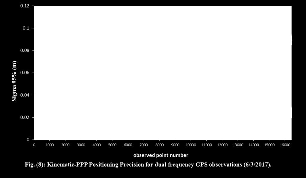
2 2 TEST STUDY A kinematic track of 27.5 km (Figure 1) was observed using combined GPS/GLONASS dual frequency observations (4 hr, 34 min.) on (6/3/2017) (GPS day 19391) at the Nile river, Aswan, Egypt. Aswan is a city sited in south Egypt ( N, E) using Leica Viva GS15 receiver (Leica Viva, 2017) with 1 sec observation recording interval and 10 o elevation mask angle. The observations file was undergoing quality check using the software TEQC "translate, edit, quality check" GNSS data tool (TEQC, 2017). The observations file was divided into three files using TEQC software; combined (GPS/GLONASS) file, GPS-only file and GLONASS-only file.the PPP solutions were estimated for the three files through Canadian Spatial Reference System (CSRS) Precise9 Point Positioning (PPP) service (CSRS-PPP, 2017). Figure 1. The Nile River observed kinematic track using dual-frequency combined (GPS/GLONASS) (6/3/2017) (GoogleEarth, 2017). Table 1 shows the average number of visible satellites and Dilution of Precision (DOP) values; Horizontal DOP, Vertical DOP and Position DOP (HDOP&VDOP&PDOP) during observations collection period for GPS, GLONASS and combined GPS/GLONASS. Table 1. The average no. of visible satellites and average DOP values for tested constellations. Constellation Average no. visible satellites Average HDOP Average VDOP Average PDOP GPS GLONASS GPS/GLONASS Figures 2 to 7 show variation of the average number of visible satellites and Dilution of Precision (DOP) values during observations collection period for GPS, GLONASS and combined GPS/GLONASS constellations. 654
3 3 RESULTS & DISCUSSION Figures 8 to 10 present PPP-kinematic precision variation using different constellations; GPS, GLONASS and combined GPS/GLONASS.Table (2) presents statistical analysis for kinematic-ppp precision using different constellations. 655
4 656
5 Table 2: Statistical Analysis for Kinematic-PPP precision variation using different constellations. Constellatio n Sigma (m) Sigm a latitu de GPS GLONASS Combined GPS/GLONASS Sigma Sigma Sigma Sigma Sigma Sigma Sigma Sigma longitu height latitu longitu height latitu longitu height de de de de de Maximum( m) Minimum(m ) Average(m) St Deviation(m ) CONCLUSIONS This research presents an evaluation study for the variability of kinematic-ppp precision for hydrography using dual frequency observations based on different constellations; GPS, GLONASS and combined (GPS/GLONASS).GPS offers average precision of 18.5 mm, 49 mm for Hz. and vertical coordinates respectively. GLONASS offers average precision of 43.5 mm horizontally and 129 mm vertically. Combined GPS/GLONASS constellation offers average precision of 13.5 mm horizontally and 37 mm vertically. GPS constellation offers better no. of visible satellites and DOP values comparing with GLONASS which improves kinematic-ppp precision by 60%. Combined constellation offers more number of visible satellites and better DOP values which improves kinematic-ppp precision by 26% over GPS constellation and 71% over GLONASS constellation. REFERENCES Bisnath S., Gao Y. (2008). Current State of Precise Point Positioning and Future Prospects and Limitations. International Association of Geodesy Symposia, Vol. 133 pp , Cai, C., Gao,Y (2013). GLONASS-based precise point positioning and performance analysis, in: Advances in Space Research 51 (2013) CSRS-PPP (2017). Canadian Spatial Reference System (CSRS) Precise Point Positioning (PPP) service. Accessed (10/3/2017). Geng J, Teferle FN, Meng X, Dodson AH (2010). Kinematic precise point positioning at remote marine platforms. GPS Solutions. 14(4): GLONASS (2017). GLONASS constellation status. Federal space agency-information analytical centre. Accessed (5/3/2017) Leica Viva (2017). Leica Geosystems products. Accessed (5/3/2017). TEQC (2017). TEQC-UNAVCO tutorial. _Teqc_ Tutorial.pdf. Accessed (5/1/2017). 657
6 Tolman, B.W., Kerkhoff, A., Rainwater, D., Munton, D., Banks, J.(2010) Absolute precise kinematic positioning with GPS and GLONASS, in: Proc. ION GNSS 2010, Portland, Oregon, pp , September 21 24, Zumberge, J. F., M. B. Heflin, D. C. Jefferson, M. M. Watkins, and F. H. Webb (1997): Precise Point Processing for the Efficient and Robust Analysis of GPS Data from Large Networks, J. Geophys. Res., 102(B3),
GPS STATIC-PPP POSITIONING ACCURACY VARIATION WITH OBSERVATION RECORDING INTERVAL FOR HYDROGRAPHIC APPLICATIONS (ASWAN, EGYPT)
") GPS STATIC-PPP POSITIONING ACCURACY VARIATION WITH OBSERVATION RECORDING INTERVAL FOR HYDROGRAPHIC APPLICATIONS (ASWAN, EGYPT) Ashraf Farah Associate Professor,College of Engineering, Aswan University,
GPS STATIC-PPP POSITIONING ACCURACY VARIATION WITH OBSERVATION RECORDING INTERVAL FOR HYDROGRAPHIC APPLICATIONS (ASWAN, EGYPT) Ashraf Farah Associate Professor,College of Engineering, Aswan University,
GLONASS-based Single-Frequency Static- Precise Point Positioning
 GLONASS-based Single-Frequency Static- Precise Point Positioning Ashraf Farah College of Engineering Aswan University Aswan, Egypt e-mail: ashraf_farah@aswu.edu.eg Abstract Precise Point Positioning (PPP)
VARIATION OF STATIC-PPP POSITIONING ACCURACY USING GPS-SINGLE FREQUENCY OBSERVATIONS (ASWAN, EGYPT)
") ARTIFICIAL SATELLITES, Vol. 52, No. 2 2017 DOI: 10.1515/arsa-2017-0003 VARIATION OF STATIC-PPP POSITIONING ACCURACY USING GPS-SINGLE FREQUENCY OBSERVATIONS (ASWAN, EGYPT) Ashraf Farah Associate professor,
ARTIFICIAL SATELLITES, Vol. 52, No. 2 2017 DOI: 10.1515/arsa-2017-0003 VARIATION OF STATIC-PPP POSITIONING ACCURACY USING GPS-SINGLE FREQUENCY OBSERVATIONS (ASWAN, EGYPT) Ashraf Farah Associate professor,
Accuracy assessment of free web-based online GPS Processing services and relative GPS solution software
 82 Accuracy assessment of free web-based online GPS Processing services and relative GPS solution software Khaled Mahmoud Abdel Aziz Department of Surveying Engineering, Shoubra Faculty of Engineering,
Experiences with Fugro's Real Time GPS/GLONASS Orbit/Clock Decimeter Level Precise Positioning System
 Return to Session Directory DYNAMIC POSITIONING CONFERENCE October 13-14, 2009 Sensors Experiences with Fugro's Real Time GPS/GLONASS Orbit/Clock Decimeter Level Precise Positioning System Ole Ørpen and
Performance Evaluation Of Real Time Precise Point Positioning (RT-PPP) In Static & Kinematic Modes In Egypt
 In Static & Kinematic Modes In Egypt") Performance Evaluation Of Real Time Precise Point Positioning (RT-PPP) In Static & Kinematic Modes In Egypt Eng. Ahmed Mansour Abdallah Dr. Mahmoud Abd Rabbou Prof. Adel El.shazly Geomatic Branch, Civil
Performance Evaluation Of Real Time Precise Point Positioning (RT-PPP) In Static & Kinematic Modes In Egypt Eng. Ahmed Mansour Abdallah Dr. Mahmoud Abd Rabbou Prof. Adel El.shazly Geomatic Branch, Civil
Precise Point Positioning (PPP) using
 using") Precise Point Positioning (PPP) using Product Technical Notes // May 2009 OnPOZ is a product line of Effigis. EZSurv is a registered trademark of Effigis. All other trademarks are registered or recognized
Precise Point Positioning (PPP) using Product Technical Notes // May 2009 OnPOZ is a product line of Effigis. EZSurv is a registered trademark of Effigis. All other trademarks are registered or recognized
DYNAMIC POSITIONING CONFERENCE October 7-8, Sensors II. Redundancy in Dynamic Positioning Systems Based on Satellite Navigation
 Return to Session Directory DYNAMIC POSITIONING CONFERENCE October 7-8, 2008 Sensors II Redundancy in Dynamic Positioning Systems Based on Satellite Navigation Ole Ørpen, Tor Egil Melgård, Arne Norum Fugro
Resection. We can measure direction in the real world! Lecture 10: Position Determination. Resection Example: Isola, Slovenia. Professor Keith Clarke
 Geography 12: Maps and Spatial Reasoning Lecture 10: Position Determination We can measure direction in the real world! Professor Keith Clarke Resection Resection Example: Isola, Slovenia Back azimuth
GNSS & Coordinate Systems
 GNSS & Coordinate Systems Matthew McAdam, Marcelo Santos University of New Brunswick, Department of Geodesy and Geomatics Engineering, Fredericton, NB May 29, 2012 Santos, 2004 msantos@unb.ca 1 GNSS GNSS
One Source for Positioning Success
 novatel.com One Source for Positioning Success RTK, PPP, SBAS OR DGNSS. NOVATEL CORRECT OPTIMIZES ALL CORRECTION SOURCES, PUTTING MORE POWER, FLEXIBILITY AND CONTROL IN YOUR HANDS. NovAtel CORRECT is the
Performance Evaluation of Precise Point Positioning (PPP) Using CSRS-PPP Online Service
 Using CSRS-PPP Online Service") American Journal of Geographic Information System 2017, 6(4): 156-167 DOI: 10.5923/j.ajgis.20170604.03 Performance Evaluation of Precise Point Positioning (PPP) Using CSRS-PPP Online Service Saad Bolbol,
American Journal of Geographic Information System 2017, 6(4): 156-167 DOI: 10.5923/j.ajgis.20170604.03 Performance Evaluation of Precise Point Positioning (PPP) Using CSRS-PPP Online Service Saad Bolbol,
The Comparison of Accuracies of Results Obtained from Bernese v5.2 Software and Web-Based PPP Services
 The Comparison of Accuracies of Results Obtained from Bernese v5.2 Software and Web-Based PPP Services Seyda GELİSKAN, Cevat INAL, Sercan BULBUL and Ahmet Mete GUNDUZ, Turkey Key words: PPP, Web-based
INTEGRITY AND CONTINUITY ANALYSIS FROM GPS JULY TO SEPTEMBER 2016 QUARTERLY REPORT
 INTEGRITY AND CONTINUITY ANALYSIS FROM GPS JULY TO SEPTEMBER 2016 QUARTERLY REPORT Name Responsibility Date Signature Prepared by M Pattinson (NSL) 07/10/16 Checked by L Banfield (NSL) 07/10/16 Authorised
Asian Journal of Science and Technology Vol. 08, Issue, 11, pp , November, 2017 RESEARCH ARTICLE
 Available Online at http://www.journalajst.com ASIAN JOURNAL OF SCIENCE AND TECHNOLOGY ISSN: 0976-3376 Asian Journal of Science and Technology Vol. 08, Issue, 11, pp.6697-6703, November, 2017 ARTICLE INFO
METIS Second Master Training & Seminar. Augmentation Systems Available in Egypt
 METIS Second Master Training & Seminar Augmentation Systems Available in Egypt By Eng. Ramadan Salem M. Sc. Surveying and Geodesy Email: ramadan_salem@link.net Page 1 Augmentation Systems Available in
AUTONOMOUS ISOTROPY-BASED INTEGRITY USING GPS AND GLONASS
 ION GNSS 2010 AUTONOMOUS ISOTROPY-BASED INTEGRITY USING GPS AND GLONASS SEPTEMBER 21-24, 2010 - PORTLAND, OREGON SESSION E4: INTEGRITY MONITORING FOR NEXT GENERATION APPLICATIONS M. Azaola D. Calle A.Mozo
FieldGenius Technical Notes GPS Terminology
 FieldGenius Technical Notes GPS Terminology Almanac A set of Keplerian orbital parameters which allow the satellite positions to be predicted into the future. Ambiguity An integer value of the number of
Presented at the FIG Congress 2018, May 6-11, 2018 in Istanbul, Turkey
 Presented at the FIG Congress 2018, May 6-11, 2018 in Istanbul, Turkey 2 Improving Hydrographic PPP by Height Constraining Ashraf Abdallah (Egypt) Volker Schwieger, (Germany) ashraf.abdallah@aswu.edu.eg
International Journal of Scientific & Engineering Research, Volume 7, Issue 12, December-2016
 International Journal of Scientific & Engineering Research, Volume 7, Issue 2, December-26 642 Enhancement of Precise Point Positioning Using GPS Single Frequency Data Ibrahim F. Shaker*, Tamer F. Fath-Allah**,
Introduction to GNSS Base-Station
 Introduction to GNSS Base-Station Dinesh Manandhar Center for Spatial Information Science The University of Tokyo Contact Information: dinesh@iis.u-tokyo.ac.jp Slide : 1 Introduction GPS or GNSS observation
GNSS Accuracy Improvements through Multipath Mitigation with New Signals and services
 GNSS Accuracy Improvements through Multipath Mitigation with New Signals and services Andrey Veytsel, Ph.D Moscow Technical University 10 Meeting of the International Committee on Global Navigation Satellite
Chapter 6 GPS Relative Positioning Determination Concepts
 Chapter 6 GPS Relative Positioning Determination Concepts 6-1. General Absolute positioning, as discussed earlier, will not provide the accuracies needed for most USACE control projects due to existing
PERSPECTIVES OF FREE GNSS POST-PROCESSING SOFTWARE USING
 XIII International forum «INTEREXPO GEO-Siberia 2017» PERSPECTIVES OF FREE GNSS POST-PROCESSING SOFTWARE USING S. Shevchuk, L. Lipatnikov, K. Malyutina (Siberian State University of Geosystems and Technologies)
THE INFLUENCE OF ZENITH TROPOSPHERIC DELAY ON PPP-RTK. S. Nistor a, *, A.S. Buda a,
 THE INFLUENCE OF ZENITH TROPOSPHERIC DELAY ON PPP-RTK S. Nistor a, *, A.S. Buda a, a University of Oradea, Faculty of Civil Engineering, Cadastre and Architecture, Department Cadastre-Architecture, Romania,
Performance Evaluation of Differential Global Navigation Satellite System with RTK Corrections
 IOSR Journal of Electronics and Communication Engineering (IOSR-JECE) e-issn: 2278-2834,p- ISSN: 2278-8735.Volume 9, Issue 2, Ver. VI (Mar - Apr. 2014), PP 43-47 Performance Evaluation of Differential
Errors in GPS. Errors in GPS. Geodetic Co-ordinate system. R. Khosla Fall Semester
 Errors in GPS Errors in GPS GPS is currently the most accurate positioning system available globally. Although we are talking about extreme precision and measuring distances by speed of light, yet there
International Journal of Scientific & Engineering Research, Volume 6, Issue 8, August ISSN
 International Journal of Scientific & Engineering Research, Volume 6, Issue 8, August-2015 683 Assessment Accuracy of Static Relative Positioning Using Single Frequency GPS Receivers Mahmoud I. El-Mewafi
Precise Positioning with NovAtel CORRECT Including Performance Analysis
 Precise Positioning with NovAtel CORRECT Including Performance Analysis NovAtel White Paper April 2015 Overview This article provides an overview of the challenges and techniques of precise GNSS positioning.
Increasing PPP Accuracy Using Permanent Stations Corrections
 International Journal of Engineering and Advanced Technology (IJEAT) Increasing PPP Accuracy Using Permanent Stations Corrections Ibrahim F. Shaker, Tamer F. Fath-Allah, Mohamed M. El-Habiby, Ahmed E.
Evaluation of Multi-Constellation GNSS Precise Point Positioning (PPP) Techniques in Egypt
 Techniques in Egypt") Evaluation of Multi-Constellation GNSS Precise Point Positioning (PPP) Techniques in Egypt Mahmoud Abd Rabbou and Adel El-Shazly Department of Civil Engineering, Cairo University Presented by; Dr. Mahmoud
Evaluation of Multi-Constellation GNSS Precise Point Positioning (PPP) Techniques in Egypt Mahmoud Abd Rabbou and Adel El-Shazly Department of Civil Engineering, Cairo University Presented by; Dr. Mahmoud
Trimble Business Center:
 Trimble Business Center: Modernized Approaches for GNSS Baseline Processing Trimble s industry-leading software includes a new dedicated processor for static baselines. The software features dynamic selection
GNSS in Maritime and Education in Egypt
 GNSS in Maritime and Education in Egypt GNSS IN MARITIME PORTS SHIPS PORTS WATERWAYS GNSS maritime applications will help to improve: navigation. Ship operations. Traffic management. Seaport operations.
Precise Point Positioning Developments at GSD: Products, Services
 Precise Point Positioning Developments at GSD: Products, Services F. Lahaye, P. Collins, Y. Mireault, P. Tétreault, M. Caissy Geodetic Survey Division, Natural Resources Canada (NRCan) GEOIDE - PPP Workshop
Sources of Error in Satellite Navigation Positioning
 http://www.transnav.eu the International Journal on Marine Navigation and Safety of Sea Transportation Volume 11 Number 3 September 2017 DOI: 10.12716/1001.11.03.04 Sources of Error in Satellite Navigation
Procedures for Quality Control of GNSS Surveying Results Based on Network RTK Corrections.
 Procedures for Quality Control of GNSS Surveying Results Based on Network RTK Corrections. Limin WU, China Feng xia LI, China Joël VAN CRANENBROECK, Switzerland Key words : GNSS Rover RTK operations, GNSS
COMPARISON OF GPS COMMERCIAL SOFTWARE PACKAGES TO PROCESSING STATIC BASELINES UP TO 30 KM
 COMPARISON OF GPS COMMERCIAL SOFTWARE PACKAGES TO PROCESSING STATIC BASELINES UP TO 30 KM Khaled Mohamed Abdel Mageed Civil Engineering, Cairo, Egypt E-Mail: khaled_mgd@yahoo.com ABSTRACT The objective
Network Differential GPS: Kinematic Positioning with NASA s Internet-based Global Differential GPS
 Journal of Global Positioning Systems () Vol., No. : 9-4 Network Differential GPS: Kinematic Positioning with NASA s Internet-based Global Differential GPS M. O. Kechine, C.C.J.M.Tiberius, H. van der Marel
INTEGRITY AND CONTINUITY ANALYSIS FROM GPS JANUARY TO MARCH 2017 QUARTERLY REPORT
 INTEGRITY AND CONTINUITY ANALYSIS FROM GPS JANUARY TO MARCH 2017 QUARTERLY REPORT Name Responsibility Date Signature Prepared by M Pattinson (NSL) 11/04/17 Checked by L Banfield (NSL) 11/04/17 Authorised
Canadian Coast Guard Review to Implement a Resilient Position, Navigation and Timing Solution for Canada. Mariners Workshop January 31 st, 2018
 Canadian Coast Guard Review to Implement a Resilient Position, Navigation and Timing Solution for Canada Mariners Workshop January 31 st, 2018 Outline Overview of GNSS use in the marine sector CCG Activities
Contributions of multi-gnss constellations to Precise Point Positioning (PPP) with raw measurements model
 with raw measurements model") Contributions of multi-gnss constellations to Precise Point Positioning (PPP) with raw measurements model Fu Zheng, Yidong Lou, Shengfeng Gu Charles Wang, Hailin Guo, Yanming Feng GNSS Centre, Wuhan University
Contributions of multi-gnss constellations to Precise Point Positioning (PPP) with raw measurements model Fu Zheng, Yidong Lou, Shengfeng Gu Charles Wang, Hailin Guo, Yanming Feng GNSS Centre, Wuhan University
Kinematic PPP Positioning Using Different Processing Platforms
 Kinematic PPP Positioning Using Different Processing Platforms İ. Murat OZULU, Veli İLÇİ, Serdar EROL and Reha Metin ALKAN, Turkey Key words: GNSS, PPP, Online Processing, Kinematic Surveying, Obruk Dam
Space Weather influence on satellite based navigation and precise positioning
 Space Weather influence on satellite based navigation and precise positioning R. Warnant, S. Lejeune, M. Bavier Royal Observatory of Belgium Avenue Circulaire, 3 B-1180 Brussels (Belgium) What this talk
Automated Quality Control of Global Navigation Satellite System (GNSS) Data
 Data") P-315 Automated Quality Control of Global Navigation Satellite System (GNSS) Data S.Senthil Kumar* & Arun Kumar Chauhan, ONGC Summary Global Navigation Satellite System (GNSS), includes GPS, GLONASS and
P-315 Automated Quality Control of Global Navigation Satellite System (GNSS) Data S.Senthil Kumar* & Arun Kumar Chauhan, ONGC Summary Global Navigation Satellite System (GNSS), includes GPS, GLONASS and
Fugro Marinestar Improvements
 Fugro Marinestar Improvements Hans Visser Fugro Intersite B.V. Improvements in Marinestar Positioning Hydro 2016 Warnemünde, 10 November 2016 Overview of presentation The Marinestar GNSS Networks The supplied
ORBITS AND CLOCKS FOR GLONASS PPP
 ION GNSS 2009 ORBITS AND CLOCKS FOR GLONASS PPP SEPTEMBER 22-25, 2009 - SAVANNAH, GEORGIA SESSION E3: PPP AND NETWORK-BASED RTK 1 D. Calle A. Mozo P. Navarro R. Píriz D. Rodríguez G. Tobías September 24,
SPEEDING UP FILTER CONVERGENCE IN HIGH PRECISION, VERY LARGE AREA KINEMATIC NAVIGATION
 IMA HOT TOPICS WORKSHOP: Mathematical Challenges in Global Positioning Systems (GPS) University of Minnessota, 16-19 August 2000 SPEEDING UP FILTER CONVERGENCE IN HIGH PRECISION, VERY LARGE AREA KINEMATIC
TEST YOUR SATELLITE NAVIGATION PERFORMANCE ON YOUR ANDROID DEVICE GLOSSARY
 TEST YOUR SATELLITE NAVIGATION PERFORMANCE ON YOUR ANDROID DEVICE GLOSSARY THE GLOSSARY This glossary aims to clarify and explain the acronyms used in GNSS and satellite navigation performance testing
GLOBAL POSITIONING SYSTEMS. Knowing where and when
 GLOBAL POSITIONING SYSTEMS Knowing where and when Overview Continuous position fixes Worldwide coverage Latitude/Longitude/Height Centimeter accuracy Accurate time Feasibility studies begun in 1960 s.
RESOLUTION MSC.112(73) (adopted on 1 December 2000) ADOPTION OF THE REVISED PERFORMANCE STANDARDS FOR SHIPBORNE GLOBAL POSITIONING SYSTEM (GPS)
 (adopted on 1 December 2000) ADOPTION OF THE REVISED PERFORMANCE STANDARDS FOR SHIPBORNE GLOBAL POSITIONING SYSTEM (GPS)") MSC 73/21/Add.3 RESOLUTION MSC.112(73) FOR SHIPBORNE GLOBAL POSITIONING SYSTEM THE MARITIME SAFETY COMMITTEE, RECALLING Article (28(b) of the Convention on the International Maritime Organization concerning
MSC 73/21/Add.3 RESOLUTION MSC.112(73) FOR SHIPBORNE GLOBAL POSITIONING SYSTEM THE MARITIME SAFETY COMMITTEE, RECALLING Article (28(b) of the Convention on the International Maritime Organization concerning
GLOBAL POSITIONING SYSTEM (GPS) PERFORMANCE OCTOBER TO DECEMBER 2013 QUARTERLY REPORT. GPS Performance 08/01/14 08/01/14 08/01/14.
 PERFORMANCE OCTOBER TO DECEMBER 2013 QUARTERLY REPORT. GPS Performance 08/01/14 08/01/14 08/01/14.") GLOBAL POSITIONING SYSTEM (GPS) PERFORMANCE OCTOBER TO DECEMBER 2013 QUARTERLY REPORT Prepared by: M Pattinson (NSL) 08/01/14 Checked by: L Banfield (NSL) 08/01/14 Approved by: M Dumville (NSL) 08/01/14
GLOBAL POSITIONING SYSTEM (GPS) PERFORMANCE OCTOBER TO DECEMBER 2013 QUARTERLY REPORT Prepared by: M Pattinson (NSL) 08/01/14 Checked by: L Banfield (NSL) 08/01/14 Approved by: M Dumville (NSL) 08/01/14
Fast convergence of Trimble CenterPoint RTX by regional augmentation
 Fast convergence of Trimble CenterPoint RTX by regional augmentation Dr. Ralf Drescher Trimble Terrasat GmbH, Munich EGU General Assembly 2015, Vienna Thursday, 16 April 2015 Outline Introduction CenterPoint
Positioning Australia for its farming future
 Positioning Australia for its farming future Utilizing the Japanese satellite navigation QZSS system to provide centimetre positioning accuracy across ALL Australia David Lamb 1,2 and Phil Collier 2 1
Precise Positioning GNSS Applications
 Precise Point Positioning: Is the Era of Differential GNSS Positioning Drawing to an End? School of Surveying & Spatial Information Systems, UNSW, Sydney, Australia Chris Rizos 1, Volker Janssen 2, Craig
ION GNSS 2011 FILLING IN THE GAPS OF RTK WITH REGIONAL PPP
 ION GNSS 2011 FILLING IN THE GAPS OF RTK WITH REGIONAL PPP SEPTEMBER 22 th, 2011 ION GNSS 2011. PORTLAND, OREGON, USA SESSION F3: PRECISE POSITIONING AND RTK FOR CIVIL APPLICATION C. García A. Mozo P.
The Impact of an Integrated GPS and GLONASS Satellite Geometry in the Precision of Positioning
 The Impact of an Integrated GPS and GLONASS Satellite Geometry in the Precision of Positioning Oluropo OLAJUGBA and Chika OKOROCHA, Nigeria Keywords: Integrated, GPS, GLONASS, Geometry, Positioning SUMMARY
Analyzing GNSS data in precise point positioning software
 DOI 1.17/s1291-1-173-9 REVIEW ARTICLE Analyzing GNSS data in precise point positioning software Rodrigo F. Leandro Marcelo C. Santos Richard B. Langley Received: 25 February 29 / Accepted: 14 May 21 Ó
Assessing the Accuracy of GPS Control Point, Using Post-Processed and Absolute Positioning Data
 American Journal of Environmental Engineering and Science 2017; 4(5): 42-47 http://www.aascit.org/journal/ajees ISSN: 2381-1153 (Print); ISSN: 2381-1161 (Online) Assessing the Accuracy of GPS Control Point,
The Impact of Performance Parameters over a DGPS Satellite Navigation System
 Australian Journal of Basic and Applied Sciences, 3(4): 4711-4719, 2009 ISSN 1991-8178 The Impact of Performance Parameters over a DGPS Satellite Navigation System 1 Madad Ali Shah, 2 Noor Ahmed Shaikh,
GLOBAL POSITIONING SYSTEM (GPS) PERFORMANCE JULY TO SEPTEMBER 2018 QUARTERLY REPORT 3
 PERFORMANCE JULY TO SEPTEMBER 2018 QUARTERLY REPORT 3") GLOBAL POSITIONING SYSTEM (GPS) PERFORMANCE JULY TO SEPTEMBER 2018 QUARTERLY REPORT 3 Name Responsibility Date Signature Prepared by M McCreadie (NSL) 24/10/2018 Checked by M Pattinson (NSL) 24/10/2018
GLOBAL POSITIONING SYSTEM (GPS) PERFORMANCE JULY TO SEPTEMBER 2018 QUARTERLY REPORT 3 Name Responsibility Date Signature Prepared by M McCreadie (NSL) 24/10/2018 Checked by M Pattinson (NSL) 24/10/2018
Simulation Analysis for Performance Improvements of GNSS-based Positioning in a Road Environment
 Simulation Analysis for Performance Improvements of GNSS-based Positioning in a Road Environment Nam-Hyeok Kim, Chi-Ho Park IT Convergence Division DGIST Daegu, S. Korea {nhkim, chpark}@dgist.ac.kr Soon
Precise Positioning with Smartphones running Android 7 or later
 Precise Positioning with Smartphones running Android 7 or later * René Warnant, * Cécile Deprez, + Quentin Warnant * University of Liege Geodesy and GNSS + Augmenteo, Plaine Image, Lille (France) Belgian
Long Term Performance Analysis of a New Ground-transceiver Positioning Network (LocataNet) for Structural Deformation Monitoring Applications
 for Structural Deformation Monitoring Applications") Long Term Performance Analysis of a New Ground-transceiver Positioning Network (LocataNet) for Structural Deformation Monitoring Applications Dr. Joel BARNES, Australia, Mr. Joel VAN CRANENBROECK, Belgium,
Long Term Performance Analysis of a New Ground-transceiver Positioning Network (LocataNet) for Structural Deformation Monitoring Applications Dr. Joel BARNES, Australia, Mr. Joel VAN CRANENBROECK, Belgium,
PRECISE POINT POSITIONING USING COMBDINE GPS/GLONASS MEASUREMENTS
 PRECISE POINT POSITIONING USING COMBDINE GPS/GLONASS MEASUREMENTS Mohamed AZAB, Ahmed EL-RABBANY Ryerson University, Canada M. Nabil SHOUKRY, Ramadan KHALIL Alexandria University, Egypt Outline Introduction.
Locata: A New Constellation for High Accuracy Outdoor & Indoor Positioning
 Locata: A New Constellation for High Accuracy Outdoor & Indoor Positioning Chris Rizos, Yong Li, Nonie Politi School of Surveying & Spatial Information Systems University of New South Wales, Sydney, Australia
Multi-Constellation GNSS Precise Point Positioning using GPS, GLONASS and BeiDou in Australia
 International Global Navigation Satellite Systems Society IGNSS Symposium 2015 Multi-Constellation GNSS Precise Point Positioning using GPS, GLONASS and BeiDou in Australia Xiaodong Ren 1,Suelynn Choy
GPS and Recent Alternatives for Localisation. Dr. Thierry Peynot Australian Centre for Field Robotics The University of Sydney
 GPS and Recent Alternatives for Localisation Dr. Thierry Peynot Australian Centre for Field Robotics The University of Sydney Global Positioning System (GPS) All-weather and continuous signal system designed
ENGI 3703 Surveying and Geomatics
 Satellite Geometry: Satellites well spread out in the sky have a much stronger solution to the resection type problem (aka trilateration) then satellite that are grouped together. Since the position of
What is a GPS How does GPS work? GPS Segments GPS P osition Position Position Accuracy Accuracy Accuracy GPS A pplications Applications Applications
 What is GPS? What is a GPS How does GPS work? GPS Segments GPS Position Accuracy GPS Applications What is GPS? The Global Positioning System (GPS) is a precise worldwide radio-navigation system, and consists
An introduction to RTKLIB open source GNSS processing software. Ryan Ruddick and Suelynn Choy
 An introduction to RTKLIB open source GNSS processing software Ryan Ruddick and Suelynn Choy 1 Resources RTKLIB homepage http://www.rtklib.com GIT repository https://github.com/tomojitakasu/rtklib/ Windows
National Report of Greece to EUREF 2009
 National Report of Greece to EUREF 2009 M. Gianniou KTIMATOLOGIO S.A. (Hellenic Cadastre) 1 Introduction In 2007, KTIMATOLOGIO S.A (Hellenic Cadastre) established HEPOS, the HEllenic POsitioning System,
Rapid static GNSS data processing using online services
 J. Geod. Sci. 2014; 4:123 129 Research Article Open Access M. Berber*, A. Ustun, and M. Yetkin Rapid static GNSS data processing using online services Abstract: Recently, many organizations have begun
ION GNSS Galileo, an ace up in the sleeve for PPP techniques
 ION GNSS+ 2016 an ace up in the sleeve for PPP techniques September 15 TH, 2016 Session D3: High Precision GNSS Positioning I. Rodríguez-Pérez, L. Martínez-Fernández, G. Tobías-González, J. D. Calle-Calle,
The technical contribution of QZSS and GNSS to Tsunami early warning system
 0/17 Tsunami Workshop by Sentinel Asia @Sendai International Center Meeting Room 5 The technical contribution of QZSS and GNSS to Tsunami early warning system July 3, 2012 K. Mutoh, J. Yamashita, and S.
Connecting a Cadastral Survey to PNG94 using GNSS
 43rd Association of Surveyors PNG Congress, Lae, 12th-15th August 2009 Connecting a Cadastral Survey to PNG94 using GNSS Richard Stanaway QUICKCLOSE Workshop overview Legal requirements to connect surveys
Proceedings of Al-Azhar Engineering 7 th International Conference Cairo, April 7-10, 2003.
 Proceedings of Al-Azhar Engineering 7 th International Conference Cairo, April 7-10, 2003. MODERNIZATION PLAN OF GPS IN 21 st CENTURY AND ITS IMPACTS ON SURVEYING APPLICATIONS G. M. Dawod Survey Research
Orbit Determination for CE5T Based upon GPS Data
 Orbit Determination for CE5T Based upon GPS Data Cao Jianfeng (1), Tang Geshi (2), Hu Songjie (3), ZhangYu (4), and Liu Lei (5) (1) Beijing Aerospace Control Center, 26 Beiqing Road, Haidian Disrtrict,
REAL-TIME BRIDGE DEFLECTION AND VIBRATION MONITORING USING AN INTEGRATED GPS/ACCELEROMETER/PSEUDOLITE SYSTEM
 Proceedings, 11 th FIG Symposium on Deformation Measurements, Santorini, Greece, 23. REAL-TIME BRIDGE DEFLECTION AND VIBRATION MONITORING USING AN INTEGRATED GPS/ACCELEROMETER/PSEUDOLITE SYSTEM Xiaolin
GLOBAL POSITIONING SYSTEM (GPS) PERFORMANCE OCTOBER TO DECEMBER 2017 QUARTERLY REPORT
 PERFORMANCE OCTOBER TO DECEMBER 2017 QUARTERLY REPORT") GLOBAL POSITIONING SYSTEM (GPS) PERFORMANCE OCTOBER TO DECEMBER 2017 QUARTERLY REPORT Name Responsibility Date Signature Prepared by M Pattinson (NSL) 16/01/18 Checked by L Banfield (NSL) 16/01/18 Authorised
GLOBAL POSITIONING SYSTEM (GPS) PERFORMANCE OCTOBER TO DECEMBER 2017 QUARTERLY REPORT Name Responsibility Date Signature Prepared by M Pattinson (NSL) 16/01/18 Checked by L Banfield (NSL) 16/01/18 Authorised
GUIDANCE NOTES FOR GNSS NETWORK RTK SURVEYING IN GREAT BRITAIN
 GUIDANCE NOTES FOR GNSS NETWORK RTK SURVEYING IN GREAT BRITAIN ISSUE 4 MAY 2015 TSA Collaboration between: This leaflet has been produced to provide surveyors, engineers and their clients with guidelines
An Assessment of Mapping Functions for VTEC Estimation using Measurements of Low Latitude Dual Frequency GPS Receiver
 An Assessment of Mapping Functions for VTEC Estimation using Measurements of Low Latitude Dual Frequency GPS Receiver Mrs. K. Durga Rao 1 Asst. Prof. Dr. L.B.College of Engg. for Women, Visakhapatnam,
Global Positioning System: what it is and how we use it for measuring the earth s movement. May 5, 2009
 Global Positioning System: what it is and how we use it for measuring the earth s movement. May 5, 2009 References Lectures from K. Larson s Introduction to GNSS http://www.colorado.edu/engineering/asen/
Evaluation of the TanDEM-X Digital Elevation Model by PPP GPS -Analysis and Intermediate Results-
 Evaluation of the TanDEM-X Digital Elevation Model by PPP GPS -Analysis and Intermediate Results- XXIV FIG International Congress 2010 TS 8C New GNSS Applications and Developments Jürgen Schweitzer¹, Bimin
Methodology and Case Studies of Signal-in-Space Error Calculation
 Methodology and Case Studies of Signal-in-Space Error Calculation Top-down Meets Bottom-up Grace Xingxin Gao *, Haochen Tang *, Juan Blanch *, Jiyun Lee +, Todd Walter * and Per Enge * * Stanford University,
Preparing for the Future The IGS in a Multi-GNSS World
 Preparing for the Future The IGS in a Multi-GNSS World O. Montenbruck DLR/GSOC 1 The International GNSS Service is a federation of more than 200 institutions and organizations worldwide a Service of the
The Role of F.I.G. in Leading the Development of International Real-Time Positioning Guidelines
 The Role of F.I.G. in Leading the Development of International Real-Time Positioning Guidelines, USA Key Words: RTN, real-time, GNSS, Guidelines SUMMARY The rapid growth of real-time reference station
ANALYSIS OF GPS SATELLITE OBSERVABILITY OVER THE INDIAN SOUTHERN REGION
 TJPRC: International Journal of Signal Processing Systems (TJPRC: IJSPS) Vol. 1, Issue 2, Dec 2017, 1-14 TJPRC Pvt. Ltd. ANALYSIS OF GPS SATELLITE OBSERVABILITY OVER THE INDIAN SOUTHERN REGION ANU SREE
The International Scene: How Precise Positioning Will Underpin Critical GNSS Applications
 The International Scene: How Precise Positioning Will Underpin Critical GNSS Applications School of Civil & Environmental Engineering, UNSW, Sydney, Australia Chris Rizos Member of the IGS Governing Board
Precise GNSS Positioning for Mass-market Applications
 Precise GNSS Positioning for Mass-market Applications Yang GAO, Canada Key words: GNSS, Precise GNSS Positioning, Precise Point Positioning (PPP), Correction Service, Low-Cost GNSS, Mass-Market Application
Ambiguity Resolution (PPP-AR) For Precise Point Positioning Based on Combined GPS Observations
 For Precise Point Positioning Based on Combined GPS Observations") International Global Navigation Satellite Systems Association IGNSS Conference 2016 Colombo Theatres, Kensington Campus, UNSW Australia 6 8 December 2016 Ambiguity Resolution (PPP-AR) For Precise Point
International Global Navigation Satellite Systems Association IGNSS Conference 2016 Colombo Theatres, Kensington Campus, UNSW Australia 6 8 December 2016 Ambiguity Resolution (PPP-AR) For Precise Point
GLOBAL POSITIONING SYSTEM (GPS) PERFORMANCE JANUARY TO MARCH 2017 QUARTERLY REPORT
 PERFORMANCE JANUARY TO MARCH 2017 QUARTERLY REPORT") GLOBAL POSITIONING SYSTEM (GPS) PERFORMANCE JANUARY TO MARCH 2017 QUARTERLY REPORT Name Responsibility Date Signature Prepared by M Pattinson (NSL) 11/04/17 Checked by L Banfield (NSL) 11/04/17 Authorised
GLOBAL POSITIONING SYSTEM (GPS) PERFORMANCE JANUARY TO MARCH 2017 QUARTERLY REPORT Name Responsibility Date Signature Prepared by M Pattinson (NSL) 11/04/17 Checked by L Banfield (NSL) 11/04/17 Authorised
THE MONITORING OF BRIDGE MOVEMENTS USING GPS AND PSEUDOLITES
 Proceedings, 11 th FIG Symposium on Deformation Measurements, Santorini, Greece, 23. THE MONITORING OF BRIDGE MOVEMENTS USING GPS AND PSEUDOLITES Joel Barnes 1, Chris Rizos 1, Jinling Wang 1 Xiaolin Meng
Effect of Quasi Zenith Satellite (QZS) on GPS Positioning
 on GPS Positioning") Effect of Quasi Zenith Satellite (QZS) on GPS ing Tomoji Takasu 1, Takuji Ebinuma 2, and Akio Yasuda 3 Laboratory of Satellite Navigation, Tokyo University of Marine Science and Technology 1 (Tel: +81-5245-7365,
Effect of Quasi Zenith Satellite (QZS) on GPS ing Tomoji Takasu 1, Takuji Ebinuma 2, and Akio Yasuda 3 Laboratory of Satellite Navigation, Tokyo University of Marine Science and Technology 1 (Tel: +81-5245-7365,
Global Products for GPS Point Positioning Approaching Real-Time
 Global Products for GPS Point Positioning Approaching Real-Time Y. Gao 1, P. Heroux 2 and M. Caissy 2 1 Department of Geomatics Engineering, University of Calgary 2 Geodetic Survey Division, Natural Resources
Carrier Phase Multipath Corrections Based on GNSS Signal Quality Measurements to Improve CORS Observations
 Carrier Phase Multipath Corrections Based on GNSS Signal Quality Measurements to Improve CORS Observations Christian Rost and Lambert Wanninger Geodetic Institute Technische Universität Dresden Dresden,
Precise Point Positioning with BeiDou
 Precise Point Positioning with BeiDou Ole Ørpen Fugro Satellite Positioning AS Geodesi- og Hydrografidagene Stavanger, 12-13 Nov. 2014 Fugro 2013 Contents The G2 service Galileo Testing 2013 BeiDou Testing
PRINCIPLES AND FUNCTIONING OF GPS/ DGPS /ETS ER A. K. ATABUDHI, ORSAC
 PRINCIPLES AND FUNCTIONING OF GPS/ DGPS /ETS ER A. K. ATABUDHI, ORSAC GPS GPS, which stands for Global Positioning System, is the only system today able to show you your exact position on the Earth anytime,
What is it? History. Other systems. How does it work? Trilateration GEOG 201 4/28/2010. Instructor: Pesses 1. {06} The Global Positioning System
 What is it? {06} The Global Positioning System G.P.S. = Global Positioning System Different from G.I.S. (Geographic Information Systems) Map Interpretation & GPS Spring 2010 M. Pesses History Conceived
Performance Evaluation of Global Differential GPS (GDGPS) for Single Frequency C/A Code Receivers
 for Single Frequency C/A Code Receivers") Performance Evaluation of Global Differential GPS (GDGPS) for Single Frequency C/A Code Receivers Sundar Raman, SiRF Technology, Inc. Lionel Garin, SiRF Technology, Inc. BIOGRAPHY Sundar Raman holds a
Performance Evaluation of Global Differential GPS (GDGPS) for Single Frequency C/A Code Receivers Sundar Raman, SiRF Technology, Inc. Lionel Garin, SiRF Technology, Inc. BIOGRAPHY Sundar Raman holds a
GPS: The Basics. Darrell R. Dean, Jr. Civil and Environmental Engineering West Virginia University. Expected Learning Outcomes for GPS
 GPS: The Basics Darrell R. Dean, Jr. Civil and Environmental Engineering West Virginia University Expected Learning Outcomes for GPS Explain the acronym GPS Name 3 important tdt dates in history of GPS