CLICK HERE TO KNOW MORE
|
|
|
- Elmer Ward
- 5 years ago
- Views:
Transcription

1 CLICK HERE TO KNOW MORE
2 Should GNSS Become a National Critical Infrastructure? Ooi Wei Han, Noordin Ahmad, Shahrizal IM National Space Agency (ANGKASA) Ministry of Science, Technology and Innovation (MOSTI)

3 Outline.. GNSS and applications GNSS Infrastructure setup in Malaysia GNSS Vulnerability / Impact International Overview The way forward


4 ANGKASA Campuses Langkawi National Observatory, Kedah National Planetarium, Kuala Lumpur National Space Centre, Banting, Selangor


5 Introduction GNSS provide 2 essential pieces of information; position and time. The most well-known navigation satellite is GPS. Anything enabled with a GPS receiver can be used for navigation. It requires a minimum of 4 satellites. The current system capable to deliver accuracy from centimetre to meter level.
6 The Eras of GNSS Pioneers - Transit GPS Global available since 1994 GLONASS FOC end 2010 Upgraded GPS + GLONASS GALILEO COMPASS FOC FOC QZSS FOC IRNSS FOC


7 GNSS Applications NAVIGATION Air Transportation Terrestrial Transportation Marine Transportation ENERGY AND FOOD SUPPLY Fisheries Fuel extraction Precision Agriculture ADVANCED TECHNOLOGIES Timing Scientific Autonomous vehicles SAFETY OF LIFE Defence Surveillance Emergency Services RECREATIONAL MARKET Recreation Light vehicles Personal communication
8
, Applications")

9 GPS/GNSS Market Billions Global GPS Market: Products (Marine, Aviation, Automotive, Outdoor/fitness & GPS Enabled Smart Phones), Applications (Navigation, Machine Control, & Logistics Tracking) & Geography ( ). Reports/global-GPS-market-and-its-applications- 142.html
10 Source: GNSS market report 2013 by European GNSS Agency

11 GNSS ground infrastructure setup in Malaysia 10


12 MyRTKnet Setup by Department of Surveying and Mapping Malaysia (JUPEM) Comprises of 78 GPS reference stations with spacing of between 30 to 120 km and providing real-time corrections. Support e-cadastre surveying activities; location-based activities; fleet tracking and management.


13 MSK-DGNSS Setup by Jabatan laut Semenanjung Malaysia Remote Monitoring Station in: Port Klang and K. Terengganu Reference Station in: Bagan Datoh, Melaka, Kuantan and Kuala Besar To improve accuracy and safety of maritime navigation Increased nominal accuracy from 10-15m to 1-3m. Reduced risk of maritime accidents Faster transit times for commercial shipping.
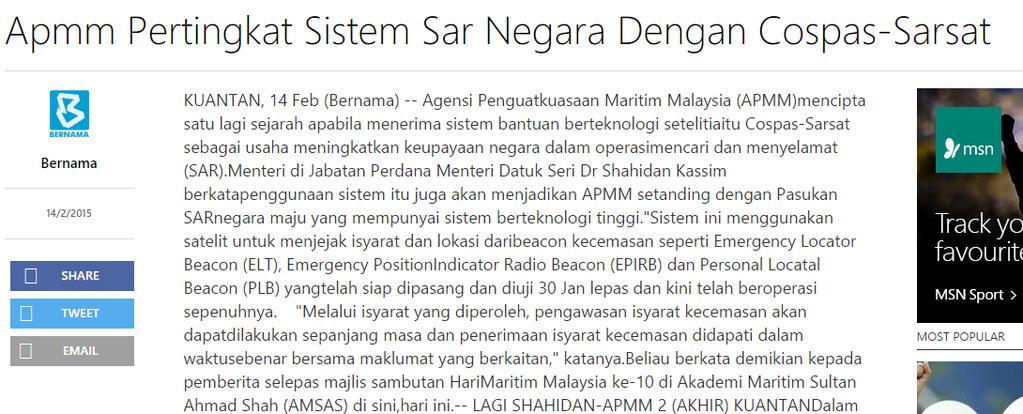
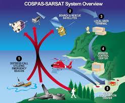
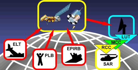
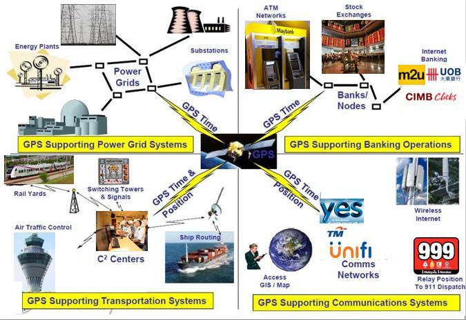
14 COSPAS-SARSAT: Search and Rescue

15 Ground Based Augmentation System Planned to setup Ground Based Augmentation System (GBAS) System determines differential corrections and integrity monitoring of GNSS. Provides navigation and precision approach service in the vicinity of the host airport


16 R&D CORS network Setup by multiple Research Institutes and University, led by ANGKASA Provide a precise and accurate GPS/GNSS satellite data correction services Become a research platform and support positioning activities


17 GNSS Vulnerabilities GPS signals are weak and easily be outpunched by poorly controlled signals from television towers or devices. Users not realise on vulnerable of devices to disruption and interference. Unintentional RFI, Multipath, signal errors, Ionospheric influence (solar max) Intentional GPS Jammer, Spoofing


18 GNSS Jamming Jamming: Broadcasting of a strong signal that overrides or obscures the signal being jammed
19

20 GNSS Spoofing Deliberate interference that aims to mislead GNSS receivers into general false positioning solution
21

22 GNSS Impact
23 Impact sector Economy Health Services Communication Transportation Energy Environment Defence Agriculture Effects Description Overreliance on GNSS signal is rampant for financial operations, inter-bank communications, transactions tracking, and etc. Disable search and rescue operations, prevent helping people who are in danger due to accident, crimes, etc Failure of GNSS timing can provide desynchronization for internet and mobile networks. Affect air traffic control, highway navigation, monitoring of cargos traffic, etc. Affect precision and real-time measurements for power grids Disable alerts systems essential for natural disasters prevention. Disable tracking emergency vehicles, tracking dangerous people wearing electronic bracelet, etc. Yields become worst, etc.

24 GNSS as critical infrastructure : International Overview
25
26
27 The Way Forward.. 1. Recognize GNSS as critical infrastructure 2. Designate and empower a lead federal official 3. Protect the adjacent bands to GNSS as Quiet neighborhoods 4. Make ownership of jammers as an offence 5. Make use of jammers a felony 6. Make anti-jamming and anti-spoofing laws enforceable at all levels of government 7. Establish a national system to detect & rapidly locate jamming 8. Ensure sufficient enforcement personnel to detect, prevent, respond to and prosecute jamming


28 end MALAYSIA
Protection Augmentation Toughness and Alternatives of GNSS. Melaha 2016 Concord Al-Salam Hotel Cairo, April 25,2016 Refaat Rashad
 Protection Augmentation Toughness and Alternatives of GNSS Melaha 2016 Concord Al-Salam Hotel Cairo, April 25,2016 Refaat Rashad Road Map of the Presentation 1- How Good are GNSS 2- How Vulnerable are
Experience with Radio Navigation Satellite Service (RNSS)
") Experience with Radio Navigation Satellite Service (RNSS) International Satellite Communication Symposium International Telecommunication Union (ITU) Geneva, 13-14 June 2016 MITOME, Takahiro Co-Chair of
Experience with Radio Navigation Satellite Service (RNSS) International Satellite Communication Symposium International Telecommunication Union (ITU) Geneva, 13-14 June 2016 MITOME, Takahiro Co-Chair of
Canadian Coast Guard Review to Implement a Resilient Position, Navigation and Timing Solution for Canada. Mariners Workshop January 31 st, 2018
 Canadian Coast Guard Review to Implement a Resilient Position, Navigation and Timing Solution for Canada Mariners Workshop January 31 st, 2018 Outline Overview of GNSS use in the marine sector CCG Activities
PERFORMANCE ANALYSIS OF SISPELSAT MSK-DGNSS RADIO SIGNAL IN PENINSULAR MALAYSIA
 PERFORMANCE ANALYSIS OF MSK-DGNSS RADIO SIGNAL IN PENINSULAR MALAYSIA M. S. A. Razak 1, T. A., Musa 1, R. Othman 1, M. F. Yazair 1, A.Z. Sha ameri 2, A. Amirudin 3, R. M. Yusof 3 1 Geomatic Innovation
Extreme space weather: Geomagnetic storms, GNSS disruptions and the impact on vital functions in society
 Extreme space weather: Geomagnetic storms, GNSS disruptions and the impact on vital functions in society Fredrik Marsten Eklöf FOI, Informationssystem fredrik.eklof@foi.se, 0709-277426 Global Navigation
European GNSS: Galileo and EGNOS for next generation Road Charging
 European GNSS: Galileo and EGNOS for next generation Road Charging 20 th October 2014 Gian Gherardo Calini European GNSS Agency (GSA) GNSS have made a huge impact in our society it is key in Road transportation
GE 113 REMOTE SENSING
 GE 113 REMOTE SENSING Topic 9. Introduction to Global Positioning Systems (GPS) and Other GNSS Technologies Lecturer: Engr. Jojene R. Santillan jrsantillan@carsu.edu.ph Division of Geodetic Engineering
European GNSS Applications in H2020
 European GNSS Applications in H2020 Countdown to H2020 12.12.2013, Brussels Carmen Aguilera European GNSS Agency Agenda European GNSS Agency EU-GNSS market potential FP7- experience and results H2020 opportunities
GNSS Training for ITS Developers. Characterisation of EGNSS performances in relationship with the application requirements
 GNSS Training for ITS Developers Characterisation of EGNSS performances in relationship with the application requirements Table of Content egnss for Application: Main Challenges EGNOS and GALILEO Performances
Overview of the global GNSS market and status of Galileo
 2012 GNSS.asia workshop Overview of the global GNSS market and status of Galileo 6 November, 2012 Taipei Justyna Redelkiewicz, European GNSS Agency European GNNS Agency supports European Commission in
Dimov Stojče Ilčev. CNS Systems
 Stratospheric Platform Systems (SPS) Presentation by: Dimov Stojče Ilčev Durban University of Technology (DUT) Space Science Centre (SSC) CNS Systems August 2011 SPS for Mobile CNS Applications Stratospheric
Nigerian Communications Satellite Ltd. (NIGCOMSAT)
") OVERVIEW OF NIGERIAN SATELLITE AUGMENTATION SYSTEM COMMENCING WITH PILOT DEMONSTRATION TO VALIDATE NATIONAL WORK PLAN presented by Dr. Lawal Lasisi Salami, NIGERIAN COMMUNICATIONS SATELLITE LTD UNDER FEDERAL
OVERVIEW OF NIGERIAN SATELLITE AUGMENTATION SYSTEM COMMENCING WITH PILOT DEMONSTRATION TO VALIDATE NATIONAL WORK PLAN presented by Dr. Lawal Lasisi Salami, NIGERIAN COMMUNICATIONS SATELLITE LTD UNDER FEDERAL
PRELIMINARY PROGRAMME
 ICG EXPERTS MEETING: GLOBAL NAVIGATION SATELLITE SYSTEMS SERVICES 14-18 December 2015 Vienna International Centre, Vienna, Austria Organized by International Committee on Global Navigation Satellite Systems
School of Civil & Environmental Engineering, UNSW, Sydney, Australia. Chris Rizos. President Australian Institute of Navigation
 The Threat to Space Based Service (for PNT applications) School of Civil & Environmental Engineering, UNSW, Sydney, Australia Chris Rizos President Australian Institute of Navigation Outline GNSS... a
Challenges and Methods for Integrity Assurance in Future GNSS
 Challenges and Methods for Integrity Assurance in Future GNSS Igor Mozharov Division Head, Information and Analytical Center for PNT, Central Research Institute for Machine Building, Roscosmos igor.mozharov@mcc.rsa.ru
The Effect of Radio Frequency Interference on GNSS Signals and Mitigation Techniques Presented by Dr. Tarek Attia
 International Conference and Exhibition Melaha2016 GNSS WAY Ahead 25-27 April2016, Cairo, Egypt The Effect of Radio Frequency Interference on GNSS Signals and Mitigation Techniques Presented by Dr. Tarek
GNSS VULNERABILITY AND CRITICAL INFRASTRUCTURE
 GNSS VULNERABILITY AND CRITICAL INFRASTRUCTURE NNF CONFERENCE 24 MAY 2012 Brynjar Hansen Senior adviser Norwegian Space Centre Lars Giske Senior adviser Norwegian Space Centre MULTI GNSS EXTERNAL COOPERATION
Jamming and Spoofing of GNSS Signals An Underestimated Risk?!
 Jamming and Spoofing of GNSS Signals An Underestimated Risk?! Alexander Rügamer Dirk Kowalewski Fraunhofer IIS NavXperience GmbH Fraunhofer IIS 1 Source: http://securityaffairs.co/wordpress/wpcontent/uploads/2012/02/spoofing.jpg
S a t e l l i t e T i m e a n d L o c a t i o n. N o v e m b e r John Fischer VP Advanced R&D
 STL - S a t e l l i t e T i m e a n d L o c a t i o n N o v e m b e r 2 0 1 7 John Fischer VP Advanced R&D jfischer@orolia.com 11/28/201 1 7 WHY AUGMENT GNSS? Recent UK Study Economic Input to UK of a
Development of Hong Kong GNSS infrastructure
 Development of Hong Kong GNSS infrastructure Wu Chen Department of Land Surveying and Geoinformatics (LSGI) Hong Kong Polytechnic University Hong Kong 1 Research Areas Research Areas GNSS Positioning and
Introduction GNSS RF interference. Jan-Joris van Es (NLR) January 2018
 January 2018") Introduction GNSS RF interference Jan-Joris van Es (NLR) January 2018 Contents Introduction Definition of RF Interference Types of RF interference Mitigation introduction GNSS RF interference, January
Introduction GNSS RF interference Jan-Joris van Es (NLR) January 2018 Contents Introduction Definition of RF Interference Types of RF interference Mitigation introduction GNSS RF interference, January
LRIT spectrum, cybersecurity and other ITU related activities
 IMSO Seminar Effective Implementation and Management of the LRIT System 15 16 February 2018, London, UK LRIT spectrum, cybersecurity and other ITU related activities Nikolai Vassiliev Chief, Terrestrial
European Radio Navigation Plan. Gilles LEQUEUX, European Commission Policy Development and Strategies
 European Radio Navigation Plan Gilles LEQUEUX, European Commission Policy Development and Strategies CONTEXT - BENEFITS Space Strategy for Europe Introduction of EGNSS in EU sectoral policies Better strategic
GLOBAL POSITIONING SYSTEMS. Knowing where and when
 GLOBAL POSITIONING SYSTEMS Knowing where and when Overview Continuous position fixes Worldwide coverage Latitude/Longitude/Height Centimeter accuracy Accurate time Feasibility studies begun in 1960 s.
GPS Evidence - Where s It Taking Us?
 GPS Evidence - Where s It Taking Us? Professor David Last International Communications Data & Digital Forensics Seminars 17-21 March 2014 Picture: earthobservatory.nasa. gov//ewsroom/bluemarble/ David
Update from the United States Space-Based Positioning, Navigation, and Timing Advisory Board
 Update from the United States Space-Based Positioning, Navigation, and Timing Advisory Board John W. Betz, PhD PNTAB Member Presented to ICG-12, Kyoto, Japan December 2017 Approved for Public Release;
Report of the Working Group B: Enhancement of Global Navigation Satellite Systems (GNSS) Services Performance
 Services Performance") Report of the Working Group B: Enhancement of Global Navigation Satellite Systems (GNSS) Services Performance 1. The Working Group on Enhancement of Global Navigation Satellite Systems (GNSS) Service Performance
Report of the Working Group B: Enhancement of Global Navigation Satellite Systems (GNSS) Services Performance 1. The Working Group on Enhancement of Global Navigation Satellite Systems (GNSS) Service Performance
Emergency Services Sector (Law Enforcement, EMS & Incident Management) Use of Positioning, Navigation and Timing (PNT) Services
 Use of Positioning, Navigation and Timing (PNT) Services") Emergency Services Sector (Law Enforcement, EMS & Incident Management) Use of Positioning, Navigation and Timing (PNT) Services These comments are based upon public and private assertions made by representatives
Emergency Services Sector (Law Enforcement, EMS & Incident Management) Use of Positioning, Navigation and Timing (PNT) Services These comments are based upon public and private assertions made by representatives
Status of the European EGNOS and Galileo Programmes. Frank Udnaes Galileo policy and Infrastructure group EC DG-TREN. June 2008
 Status of the European EGNOS and Galileo Programmes Frank Udnaes Galileo policy and Infrastructure group EC DG-TREN EUROPEAN COMMISSION z June 2008 Galileo An infrastructure 30 satellite Constellation
Positioning, location data and GNSS as solution for Autonomous driving
 Positioning, location data and GNSS as solution for Autonomous driving Jarkko Koskinen, Heidi Kuusniemi, Juha Hyyppä, Sarang Thombre and Martti Kirkko-Jaakkola FGI, NLS Definition of the Arctic 66 34 N
ESA/CNES/ARIANESPACE Service Optique CSG, S. Martin. IGNSS 2018 Sydney
 ESA/CNES/ARIANESPACE Service Optique CSG, S. Martin IGNSS 2018 Sydney GALILEO SERVICES Open Service (OS) Freely accessible service for positioning, navigation and timing Public Regulated Service (PRS)
Surviving and Operating Through GPS Denial and Deception Attack. Nathan Shults Kiewit Engineering Group Aaron Fansler AMPEX Intelligent Systems
 Surviving and Operating Through GPS Denial and Deception Attack Nathan Shults Kiewit Engineering Group Aaron Fansler AMPEX Intelligent Systems How GPS Works GPS Satellite sends exact time (~3 nanoseconds)
GPS Jamming Quantifying the Threat
 GPS Jamming Quantifying the Threat GNSS Vulnerability Countering the Threat 13 th Feb 2013 Prof. Charles Curry B.Eng, C.Eng, FIET Managing Director Chronos Technology Ltd NPL, Teddington, London Presentation
Arctic Navigation Issues. e-nav conference Nordic Institute of Navigation Bergen, March 5 th 2009
 Arctic Navigation Issues e-nav conference Nordic Institute of Navigation Bergen, March 5 th 2009 by Anna B.O. Jensen - AJ Geomatics Jean-Paul Sicard - Rovsing A/S March 2009 1 Outline Reduction of ice
GPS Jamming and its impact on maritime navigation
 GPS Jamming and its impact on maritime navigation Dr Alan Grant Research and Development - Special Interest Group 10 th May 2010 Use of GPS in the maritime sector GPS has become the normal means for maritime
GPS/QZSS Signal Authentication Concept
 GPS/QZSS Signal Authentication Concept Dinesh Manandhar, Koichi Chino, Ryosuke Shibasaki The University of Tokyo Satoshi Kogure, Jiro Yamashita, Hiroaki Tateshita Japan Aerospace Exploration Agency (JAXA)
Understanding GPS: Principles and Applications Second Edition
 Understanding GPS: Principles and Applications Second Edition Elliott Kaplan and Christopher Hegarty ISBN 1-58053-894-0 Approx. 680 pages Navtech Part #1024 This thoroughly updated second edition of an
ELECTRONIC BULLETIN For information only
 International Civil Aviation Organization ELECTRONIC BULLETIN For information only EB 2011/56 AN 7/5 21 November 2011 INTERFERENCE TO GLOBAL NAVIGATION SATELLITE SYSTEM (GNSS) SIGNALS 1. Aviation operations
Future Dual Systems for Landing. The DGNSS PALS opportunity Marco Donfrancesco Intelligence & Cyber EW Sales & Mktg
 Future Dual Systems for Landing. The DGNSS PALS opportunity Marco Donfrancesco Intelligence & Cyber EW Sales & Mktg SG-175 DGNSS PALS study The study shall provide technical advice on the data link capabilities
Lecture-1 CHAPTER 2 INTRODUCTION TO GPS
 Lecture-1 CHAPTER 2 INTRODUCTION TO GPS 2.1 History of GPS GPS is a global navigation satellite system (GNSS). It is the commonly used acronym of NAVSTAR (NAVigation System with Time And Ranging) GPS (Global
GMDSS modernisation and e-navigation: spectrum needs
 ETSI Workshop "Future Evolution of Marine Communication", 7-8 November 2017, Sophia Antipolis, France GMDSS modernisation and e-navigation: spectrum needs Karlis Bogens BR Terrestrial Services Department
GPS Interference Detection & Mitigation
 GPS Interference Detection & Mitigation GAARDIAN GNSS AVAILABILITY ACCURACY RELIABILITY and INTEGRITY ASSESSMENT for TIMING and NAVIGATION A Technology Strategy Board funded collaboration Charles Curry,
in the economy United Nations Eleventh Meeting of the International Committee on Global Navigation Satellite Systems (ICG-11) and the 17th Meeting of
 and the 17th Meeting of") Applications of highprecision GNSS solutions in the economy United Nations Eleventh Meeting of the International Committee on Global Navigation Satellite Systems (ICG-11) and the 17th Meeting of the Providers'
Applications of highprecision GNSS solutions in the economy United Nations Eleventh Meeting of the International Committee on Global Navigation Satellite Systems (ICG-11) and the 17th Meeting of the Providers'
Geoscience & Positioning, Navigation and Timing Services for Canadians
 Geoscience & Positioning, Navigation and Timing Services for Canadians Calvin Klatt, Ph.D. Director and Chief Geodesist Natural Resources Canada / Directeur et géodésien principal Ressources naturelles
GPS jamming
 Page 1 of 5 GPS jamming No jam tomorrow Navigation: As the uses of satellite-positioning technology continue to grow, what can be done to stop deliberate and dangerous jamming of the signals? Mar 10th
Introduction to GNSS opportunities in different Market Segments. Fiammetta Diani Market Development
 Introduction to GNSS opportunities in different Market Segments Fiammetta Diani Market Development fiammetta.diani@gsa.europa.eu 3-Mar-14 European GNSS Agency 2 Congratulations! Agenda European GNSS market
PROTECTING GPS/GNSS-RELIANT MILITARY SYSTEMS
 PROTECTING GPS/GNSS-RELIANT MILITARY SYSTEMS John Fischer VP Advanced R&D Jon Sinden Product Manager, Rugged PNT 6/21/2018 ABOUT OROLIA A world leader in assured positioning, navigation and timing (PNT)
Three Wishes. and an elaboration. For Reception of. Professor Bradford Parkinson Stanford University. (these are my personal views)
") Three Wishes and an elaboration For Reception of Professor Bradford Parkinson Stanford University (these are my personal views) Three Wishes - Dr, Parkinson 2017 1 Good News: World-wide dependency on GNSS
Three Wishes and an elaboration For Reception of Professor Bradford Parkinson Stanford University (these are my personal views) Three Wishes - Dr, Parkinson 2017 1 Good News: World-wide dependency on GNSS
On Location at Stanford University
 Thank you for inviting me (back) to Deutsches Zentrum für Luft- und Raumfahrt On Location at Stanford University by Per Enge (with the help of many) July 27, 2009 My thanks to the Federal Aviation Administration
Precise Positioning... what does it mean? Precise GNSS Positioning Not just a niche technology. Chris Rizos 15/12/15
 Precise GNSS Positioning Not just a niche technology Chris Rizos Precise Positioning... what does it mean? 1 Precise Positioning... a spectrum of users... Few mm 1cm 2cm < dm 1dm sub-m Precision agriculture
Current Challenges (and Solutions) in Satellite Navigation. Omar García Crespillo Institute of Communication and Navigation
 in Satellite Navigation. Omar García Crespillo Institute of Communication and Navigation") Current Challenges (and Solutions) in Satellite Navigation Omar García Crespillo Institute of Communication and Navigation Satellite Navigation Application Fields Navigation: automotive, aircrafts, shipping,
Current Challenges (and Solutions) in Satellite Navigation Omar García Crespillo Institute of Communication and Navigation Satellite Navigation Application Fields Navigation: automotive, aircrafts, shipping,
GSA GNSS Technology Report Main highlights IPIN 2018
 GSA GNSS Technology Report Main highlights IPIN 2018 Justyna Redelkiewicz, European GNSS Agency 25 September 2018, Nantes The European GNSS Agency (GSA) is responsible for market development and operations
Update on BeiDou Navigation Satellite System
 Update on BeiDou Navigation Satellite System 1 BDS Development 2 Near-term Plans BD-2 System FOC services from December, 2012 (5GEO+5IGSO+4MEO) Two on-orbit backup satellites launched in 2016 (1 IGSO+1
Understanding GPS/GNSS
 Understanding GPS/GNSS Principles and Applications Third Edition Contents Preface to the Third Edition Third Edition Acknowledgments xix xxi CHAPTER 1 Introduction 1 1.1 Introduction 1 1.2 GNSS Overview
The International Scene: How Precise Positioning Will Underpin Critical GNSS Applications
 The International Scene: How Precise Positioning Will Underpin Critical GNSS Applications School of Civil & Environmental Engineering, UNSW, Sydney, Australia Chris Rizos Member of the IGS Governing Board
GEONET -CORS Network of japan-
 GEONET -CORS Network of japan- Basara Miyahara Geospatial Information Authority of Japan Geospatial and GNSS CORS Infrastructure Forum Kuala Lumpur - Malaysia Geospatial Information Authority of Japan
DYNAMIC POSITIONING CONFERENCE October 7-8, Sensors II. Redundancy in Dynamic Positioning Systems Based on Satellite Navigation
 Return to Session Directory DYNAMIC POSITIONING CONFERENCE October 7-8, 2008 Sensors II Redundancy in Dynamic Positioning Systems Based on Satellite Navigation Ole Ørpen, Tor Egil Melgård, Arne Norum Fugro
IMPLEMENTATION OF GNSS BASED SERVICES
 International Civil Aviation Organization IMPLEMENTATION OF GNSS BASED SERVICES Julio Siu Communications, Navigation and Surveillance Regional Officer ICAO NACC Regional Office ICAO Workshop on PBN Airspace
Performance Evaluation of Differential Global Navigation Satellite System with RTK Corrections
 IOSR Journal of Electronics and Communication Engineering (IOSR-JECE) e-issn: 2278-2834,p- ISSN: 2278-8735.Volume 9, Issue 2, Ver. VI (Mar - Apr. 2014), PP 43-47 Performance Evaluation of Differential
السلطة البحرية االردنية Jordan Maritime Authority
 السلطة البحرية االردنية السلطة البحرية االردنية Humans have always been interested in where things are السلطة البحرية االردنية One of the basic questions have always been where I am? which leads to where
Photo: HERO/Nordlicht
 Research Port Rostock - Network for Maritime Applications Photo: HERO/Nordlicht Structure t Who we are What we do What we want Video nereus Brussels 2 Structure t Who we are What we do What we want Video
Report of Working Group B: Enhancement of Global Navigation Satellite Systems Services Performance
 Report of : Enhancement of Global Navigation Satellite Systems Services Performance 1. The Working Group on Enhancement of Global Navigation Satellite Systems (GNSS) Service Performance (WG-B) of the International
General Assembly. United Nations A/AC.105/946
 United Nations A/AC.105/946 General Assembly Distr.: General 16 November 2009 Original: English Committee on the Peaceful Uses of Outer Space Report on the United Nations/Azerbaijan/United States of America/European
Multi-sensor Navigation Systems: Concepts, Evolution, Trends and Applications
 Multi-sensor Navigation Systems: Concepts, Evolution, Trends and Applications Dorota A. Grejner-Brzezinska Lowber B. Strange Endowed Professor and Chair Department of Civil, Environmental and Geodetic
«Current state and prospects of development of commercial application GLONASS/GNSS in the Russian Federation»
 «Current state and prospects of development of commercial application GLONASS/GNSS in the Russian Federation» United Nations SYMPOSIUM TO STRENGTHEN THE PARTNERSHIP WITH INDUSTRY COMMERCIAL APPLICATIONS
GNSS Threats at Airports and detecting them
 GNSS Threats at Airports and detecting them Guy Buesnel, Romain Zimmermann, October 2017 Overview of Spirent Positioning and Timing Mobile Devices Military Applications Commercial Air Travel Automotive
Method, algorithm and implementation of vehicles GNSS information protection with help of anti-jamming and anti-spoofing
 Method, algorithm and implementation of vehicles GNSS information protection with help of anti-jamming and anti-spoofing Larisa Dobryakova 1, Lukasz Lemieszewski 2 and Evgeny Ochin 3 1 West Pomeranian
Introduction to GNSS Base-Station
 Introduction to GNSS Base-Station Dinesh Manandhar Center for Spatial Information Science The University of Tokyo Contact Information: dinesh@iis.u-tokyo.ac.jp Slide : 1 Introduction GPS or GNSS observation
Resection. We can measure direction in the real world! Lecture 10: Position Determination. Resection Example: Isola, Slovenia. Professor Keith Clarke
 Geography 12: Maps and Spatial Reasoning Lecture 10: Position Determination We can measure direction in the real world! Professor Keith Clarke Resection Resection Example: Isola, Slovenia Back azimuth
Trimble GNSS Infrastructure
 Trimble GNSS Infrastructure A History of Innovation Trimble, the first company to offer commercial GPS products company to integrate GPS with communications technology RTK system in the market in 1994
Introduction to the Global Positioning System
 GPS for Fire Management - 2004 Introduction to the Global Positioning System Pre-Work Pre-Work Objectives Describe at least three sources of GPS signal error, and identify ways to mitigate or reduce those
IMO WORLD-WIDE RADIONAVIGATION SYSTEM (WWRNS) GALILEO receiver performance standards. Submitted by the European Commission
 GALILEO receiver performance standards. Submitted by the European Commission") INTERNATIONAL MARITIME ORGANIZATION E IMO SUB-COMMITTEE ON SAFETY OF NAVIGATION 50th session Agenda item 13 2 April 2004 Original: ENGLISH WORLD-WIDE RADIONAVIGATION SYSTEM (WWRNS) GALILEO receiver performance
INTERNATIONAL MARITIME ORGANIZATION E IMO SUB-COMMITTEE ON SAFETY OF NAVIGATION 50th session Agenda item 13 2 April 2004 Original: ENGLISH WORLD-WIDE RADIONAVIGATION SYSTEM (WWRNS) GALILEO receiver performance
TACOT Project. Trusted multi Application receiver for Trucks. Bordeaux, 4 June 2014
 TACOT Project Trusted multi Application receiver for Trucks Bordeaux, 4 June 2014 Agenda TACOT Context & Solution Technical developments Test & Validation results Conclusions GNSS ease our lives GNSS is
Satellite-Based Augmentation System (SBAS) Integrity Services
 Integrity Services") Satellite-Based Augmentation System (SBAS) Integrity Services Presented To: Munich, Germany Date: March 8, 2010 By: Leo Eldredge, Manager GNSS Group, FAA FAA Satellite Navigation Program 2 Wide Area Augmentation
Satellite-Based Augmentation System (SBAS) Integrity Services Presented To: Munich, Germany Date: March 8, 2010 By: Leo Eldredge, Manager GNSS Group, FAA FAA Satellite Navigation Program 2 Wide Area Augmentation
Testing Telemetry Systems, which use GNSS Satellite Navigation Systems Achieving Reliable and accurate Results with RF Simulation of GNSS Signals
 Testing Telemetry Systems, which use GNSS Satellite Navigation Systems Achieving Reliable and accurate Results with RF Simulation of GNSS Signals Karen von Hünerbein 1, Werner Lange 2 Lange-Electronic
GNSS Status and Vulnerabilities
 GNSS Status and Vulnerabilities ITSF 2011 1-3 November 2011 Marc A. Weiss, Ph.D. Time and Frequency Division National Institute of Standards and Technology mweiss@boulder.nist.gov/ ++1-303-497-3261 This
Recommendations on Differential GNSS
 Recommendations on Differential GNSS Mr. Joseph W. Spalding USCG Research & Development Center Dr. Jacques Beser S Navigation Inc. Dr. Frank van Diggelen Ashtech, Inc. BIOGRAPHY Mr. Joseph Spalding is
Time Firewall: Securing the GNSS receivers against Spoofing/Jamming. Shemi Prazot AccuBeat
 Time Firewall: Securing the GNSS receivers against Spoofing/Jamming Shemi Prazot AccuBeat 1 The need The GNSS systems are widely used for both navigation and timing in civilian infrastructures and military
Galileo. Opportunities and Challenges by Gard Ueland. November 22, 2011, Brussels. Secure World Foundation Conference. Chairman Galileo Services
 Galileo Opportunities and Challenges by Gard Ueland Chairman Galileo Services Secure World Foundation Conference The Brussels Space Policy Round Table - Galileo November 22, 2011, Brussels Galileo Launch
NCS TITAN. The most powerful GNSS Simulator available. NCS TITAN Datasheet. Scalability. Extendability. In co-operation with
 NCS TITAN The most powerful GNSS Simulator available Scalability Fidelity Reliability Usability Extendability Flexibility Upgradability Features Signal Capabilities Support of all global (GNSS) and regional
Galileo Aktueller Stand der Entwicklung
 Galileo Aktueller Stand der Entwicklung Is there a positive perspective for Galileo? Dr. Philipp Berglez TeleConsult Austria GmbH GSV-Forum Galileo das europäische Satellitennavigationssystem eine neue
GALILEO& EGNOS THE EU SATELLITE NAVIGATION PROGRAMMES EXPLAINED. Satellite Navigation EU SATNAV
 GALILEO& EGNOS THE EU SATELLITE NAVIGATION PROGRAMMES EXPLAINED EU SATNAV Satellite Navigation TABLE OF CONTENTS 22 GALILEO EGNOS EU SATELLITE NAVIGATION EUROPE MEETS SPACE...3 GALILEO, A SATELLITE NAVIGATION
Next Generation Positioning Infrastructure
 Next Generation Positioning Infrastructure The GNSS Network in the 21 st Century Joel VAN CRANENBROECK & Partners Beyond East & West GeoSensing Community 1 INFRASTRUCTURE "The installations that form the
Effect of Radio Frequency Interference (RFI) on the Precision of GPS Relative Positioning
 on the Precision of GPS Relative Positioning") IOP Conference Series: Earth and Environmental Science OPEN ACCESS Effect of Radio Frequency Interference (RFI) on the Precision of GPS Relative Positioning To cite this article: A N Idris et al 2014 IOP
IOP Conference Series: Earth and Environmental Science OPEN ACCESS Effect of Radio Frequency Interference (RFI) on the Precision of GPS Relative Positioning To cite this article: A N Idris et al 2014 IOP
Understanding AIS. The technology, the limitations and how to overcome them with Lloyd s List Intelligence
 Understanding AIS The technology, the limitations and how to overcome them with Lloyd s List Background to AIS The Automatic Identification System (AIS) was originally introduced in order to improve maritime
GPS (GNSS) Telecom Time Now and Future 2011 Telcordia-NIST-ATIS Workshop on Synchronization in Telecommunications Systems May 10-12, 2011
 Telecom Time Now and Future 2011 Telcordia-NIST-ATIS Workshop on Synchronization in Telecommunications Systems May 10-12, 2011") GPS (GNSS) Telecom Time Now and Future 2011 Telcordia-NIST-ATIS Workshop on Synchronization in Telecommunications Systems May 10-12, 2011 Marc A. Weiss, Ph.D. Time and Frequency Division National Institute
GPS (GNSS) Telecom Time Now and Future 2011 Telcordia-NIST-ATIS Workshop on Synchronization in Telecommunications Systems May 10-12, 2011 Marc A. Weiss, Ph.D. Time and Frequency Division National Institute
GAJET, a DRDC Evaluation Testbed for Navigation Electronic Warfare. Michel Clénet
 GAJET, a DRDC Evaluation Testbed for Navigation Electronic Warfare Michel Clénet Outline Introduction CRPA project at DRDC Ottawa GAJET: An Evaluation Test bed for GPS Anti-Jam System An AJ simulation
L AGENCE NATIONALE DES FREQUENCES (ANFR) From Titanic to satellite from Morse to digital Entry in a new era for the maritime community
 From Titanic to satellite from Morse to digital Entry in a new era for the maritime community") L AGENCE NATIONALE DES FREQUENCES (ANFR) From Titanic to satellite from Morse to digital Entry in a new era for the maritime community ITU regional seminar 6-8 June 2018 St-Petersburg, Russian Federation
L AGENCE NATIONALE DES FREQUENCES (ANFR) From Titanic to satellite from Morse to digital Entry in a new era for the maritime community ITU regional seminar 6-8 June 2018 St-Petersburg, Russian Federation
Spectrum Monitoring and Geolocation Systems
 Spectrum Monitoring and Geolocation Systems CRFS Ltd An overview of contemporary radio spectrum monitoring practice and the sensor and geolocation technologies to meet the emerging challenges White Paper:
Spectrum Management: Policy and Regulatory Models
 Spectrum Management: Policy and Regulatory Models American Meteorological Society Policy Program May 25, 2016 Scott Pace George Washington University Space Policy Institute Washington, D.C. GPS enables
The Role of Positioning Infrastructure in the Technological Future of the Profession by Matt Higgins
 The Role of Positioning Infrastructure in the Technological Future of our Profession Matt Higgins Vice President Presentation Outline An explanation of Positioning Infrastructure; The Economic and Environmental
EUROPEAN GNSS ADOPTION OPPORTUNITIES IN TRANSPORT WITH FOCUS ON RAIL
 EUROPEAN GNSS ADOPTION OPPORTUNITIES IN TRANSPORT WITH FOCUS ON RAIL Gian Gherardo Calini European GNSS Agency III Workshop GNSS Technology Advances in a Multi-Constellation Framework 22 January 2016 This
GS Keynote. by Gard Ueland Chairman of Galileo Services. ENC 2012 April 25 th, 2012 Gdańsk
 GS Keynote by Gard Ueland Chairman of Galileo Services ENC 2012 April 25 th, 2012 Gdańsk - GNSS applications and services - Best Growth Opportunity for Europe 2 Market applications and consumer services
FAST AND LIABLE CARTOGRAPHY UPDATE USING EGNOS AND GALILEO
 (1) (2) FAST AND LIABLE CARTOGRAPHY UPDATE USING EGNOS AND GALILEO Manuel Toledo (1), Angel Gavín (2) GMV S.A., Isaac Newton 11, P.T.M. Tres Cantos, 28760 Madrid, Spain, E-mail: mtoledo@gmv.es; agavin@gmv.es
FieldGenius Technical Notes GPS Terminology
 FieldGenius Technical Notes GPS Terminology Almanac A set of Keplerian orbital parameters which allow the satellite positions to be predicted into the future. Ambiguity An integer value of the number of
Civil GPS Service Interface Committee (CGSIC) International Committee on GNSS November 2016
 International Committee on GNSS November 2016") Civil GPS Service Interface Committee (CGSIC) International Committee on GNSS 06-11 November 2016 Russell Holmes CGSIC Deputy Chair U.S. Coast Guard Navigation Center 30 th Anniversary of the CGSIC CGSIC
Civil GPS Service Interface Committee (CGSIC) International Committee on GNSS 06-11 November 2016 Russell Holmes CGSIC Deputy Chair U.S. Coast Guard Navigation Center 30 th Anniversary of the CGSIC CGSIC
GNSS Services and Applications: Views from the European GNSS Downstream Industry
 GNSS Services and Applications: Views from the European GNSS Downstream Industry By Aureline Borel Galileo Services Permanent Representative EU Regional Workshop on Space Application in Latin America 08
Applying Defence-in-depth to counter RF interferences over GNSS
 Applying Defence-in-depth to counter RF interferences over GNSS IET 5th Oct. 2011 Xavier Bertinchamps - GSA Objective of this presentation Understand Jamming threat on GNSS Propose a comprehensive strategy
RFI Impact on Ground Based Augmentation Systems (GBAS)
") RFI Impact on Ground Based Augmentation Systems (GBAS) Nadia Sokolova SINTEF ICT, Dept. Communication Systems SINTEF ICT 1 GBAS: General Concept - improves the accuracy, provides integrity and approach
RFI Impact on Ground Based Augmentation Systems (GBAS) Nadia Sokolova SINTEF ICT, Dept. Communication Systems SINTEF ICT 1 GBAS: General Concept - improves the accuracy, provides integrity and approach
On Location at Stanford University
 Thank you for inviting me to Calgary On Location at Stanford University by Per Enge (with the help of many) May 29, 2009 With Gratitude to the Federal Aviation Administration from Misra and Enge, 2006