GPS Jamming and its impact on maritime navigation
|
|
|
- Norah Terry
- 5 years ago
- Views:
Transcription

1 GPS Jamming and its impact on maritime navigation Dr Alan Grant Research and Development - Special Interest Group 10 th May 2010
2 Use of GPS in the maritime sector GPS has become the normal means for maritime positioning, navigation and timing. The level of integration onboard is different for each vessel depending on equipment fitted.


3 GPS Vulnerabilities Accidental Natural events GPS failures TV antenna Jamming unit left on accidentally GPS antenna hardware failure Satellites orbit ~20,000km above the Earth Intentional Arranged jamming trials Illegal use of jamming units

4 Pictures: Courtesy of Prof. David Last


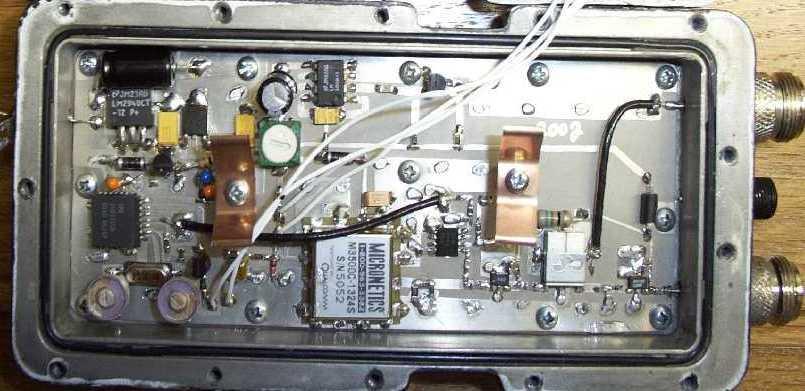
5 GPS Jammer GPS, Galileo & GLONASS bands Courtesy of Prof. David Last


6 Satellite jamming equipment w as used to stop lorries being tracked after the y were stolen Source:

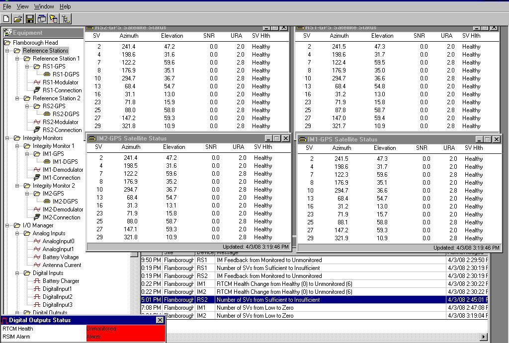
7 GLA GPS Jamming trials The GLAs have conducted two trials investigating the effects of GPS jamming. April 2008 off Flamborough Head December 2009 off Newcastle Upon Tyne For both trials the jamming units were provided and operated by the Ministry of Defence through their Defence Science and Technology Laboratories (DSTL) Newcastle Upon Tyne Flamborough Head


8 Flamborough Head trial Effect of GPS jamming on safe navigation Aids to Navigation (AtoN) eloran Differential GPS AIS as an AtoN On Ship Navigation systems Situational awareness On Shore Vessel Traffic Management On People Safe navigation Coverage area of the GPS jamming unit at 25m above ground level on maximum power of 1.58W ERP. (Image courtesy of DSTL)

9 eloran Reported position from eloran receiver operating in Eurofix corrected GPS mode during control run with no jamming. Reported position from eloran receiver operating in Calibrated eloran mode with jamming enabled

10 Differential GPS The GLAs operate 14 DGPS stations


11 Differential GPS


12 Synchronised Lights Synchronised lights simulating a port approach Lights use GPS as a common timing source


13 Ship systems Positions plotted using GPRMC NMEA data from run without jamming Erroneous reported positions as effect of jamming signal is observed. Colours indicate reported speed: blue <15knts, yellow< 50knts, orange <100knots and red >100knts

14 Ship systems GPS reported position is inland and 22km away from true position (eloran). Colours indicate reported speed: blue <15knts, yellow< 50knts, orange <100knots and red >100knts
15 Effect on Ship & Shore The effect of GPS jamming on AIS was observed by: NLV Pole Star s AIS alarmed when GPS was lost. Without GPS it could not provide a range or bearing to surrounding vessels or AtoNs. Some AIS returns included erroneous positions.

16 Effect on Ship & Shore Image courtesy of the MCA


17 People NLV Pole Star s crew were able to navigate safely during GPS outage. However, it should be noted: Vessel s crew had advanc e knowledge Parallel indexing on Radar Switched ECDIS s creen off Severity of GPS deni al depends on: Ability of crew to use traditional means Availability of traditional means During entry and exi t of the jamming regi on system alarms sounded for around 5 mi nutes.

18 Flamborough Conclusions GPS jamming can severely affect the safety of the mariner GPS jamming resulted in: Numerous alarms on the bridge Erroneous GPS positions NLB Pole Star Failure of GPS fed equipment Erroneous information presented on the vessels ECDIS Misleading information presented by the vessels AIS Reduced situational awareness

19 Newcastle Demonstrati ons Demonstrations of the effect of GPS jamming on a typical vessel to encourage the development of resilient Position, Navigation and Timing information. Audience represented: UK Government European Governments DGPS Service providers Mariners Industry Press THV Galatea

20 Demonstrati on approach Two scenarios were demonstrated: Full signal denial The jamming signal is significantly greater than the GPS signal and prevents GPS reception Comparable signal The jamming signal is slowly increased to simulate a vessel steaming towards a jamming source.


21 Ship installation For the demonstrations additional equipment was installed on the demonstration vessel: A typical Electronic Chart Display amended to show two positions -A GPS position -A eloran position
 eloran has different")
22 eloran The Newcastle trial used eloran with a reference s tation installed in South Shields. The reference station took under 24hrs to install, reference its position and resulted in an eloran position accurate to <9m (95%) eloran has different failure modes to GNSS and was used as the truth in the demons trations.

23 Observed effects

24 Observed GPS position errors Erroneous GPS positions were observed on both typical GPS receivers installed for the demonstration. Observers with their own handheld GPS receivers observed erroneous positions, with Ireland and Eastern Europe favourite destinations. Not always this marked, subtle errors, giving Hazardous Misleading Information were also observed


25 Observed effects on AIS AIS Display under normal conditions AIS Display under ful l jamming conditions

26 Source:


27 Reverting to traditional means RADAR Alarms at the loss of GPS Can be misleading if AIS is overlaid Gyrocompass Alarms at the loss of GPS Drift errors can occur over time
28 Conclusions GPS jamming whether by intentional or unintentional means significantly affects maritime navigation. GPS jamming can cause Hazardous and Misleading information The level of disruption is dependent on: the make and model of the equipment installed on the vessel the configuration of the equipment (i.e. inputs to the ECDIS) the signal strength of the jamming signal eloran was demonstrated as a complimentary navigation system to GNSS providing a position of <9m (95%) providing seamless navigation. The GLAs recommend the use of multiple means of navigation and support the development of resilient PNT.

29 Thank you Contact Informati on Dr. Alan Grant, alan.grant@gl a-rrnav.org, Phone: +44 (0)
Canadian Coast Guard Review to Implement a Resilient Position, Navigation and Timing Solution for Canada. Mariners Workshop January 31 st, 2018
 Canadian Coast Guard Review to Implement a Resilient Position, Navigation and Timing Solution for Canada Mariners Workshop January 31 st, 2018 Outline Overview of GNSS use in the marine sector CCG Activities
Protection Augmentation Toughness and Alternatives of GNSS. Melaha 2016 Concord Al-Salam Hotel Cairo, April 25,2016 Refaat Rashad
 Protection Augmentation Toughness and Alternatives of GNSS Melaha 2016 Concord Al-Salam Hotel Cairo, April 25,2016 Refaat Rashad Road Map of the Presentation 1- How Good are GNSS 2- How Vulnerable are
02 Issue. e-navigation News. GNSS Vulnerability. Dublin Bay Digital Diamond. e-navigation. Demonstrator Update International. e-navigation.
 CORPORATE SECURITY TEAMWORK EVENTS 02 Issue e-navigation News GNSS Vulnerability Dublin Bay Digital Diamond e-navigation Demonstrator Update International e-navigation update June 2014 www.cil.ie +353
Absolute Positioning by Radar
 Absolute Positioning by Radar Dr Nick Ward, Research Director General Lighthouse Authorities of UK & Ireland 14th IAIN Congress 2012, 01-03 October, 2012 - Cairo, Egypt Seamless Navigation (Challenges
COMMUNICATIONS FOR MARITIME SAFETY AND EFFICIENCY. Francis Zachariae, Secretary-General, IALA
 COMMUNICATIONS FOR MARITIME SAFETY AND EFFICIENCY Francis Zachariae, Secretary-General, IALA IALA and its Purpose Non profit, international technical association established in 1957 Two Goals aimed at
Using a Pilot Laptop with the AIS pilot plug - observed errors and difficulties
 Using a Pilot Laptop with the AIS pilot plug - observed errors and difficulties 2 nd November 2008 The following pages and images detail the errors found and experience in using his Pilot Laptop by a Australian
S a t e l l i t e T i m e a n d L o c a t i o n. N o v e m b e r John Fischer VP Advanced R&D
 STL - S a t e l l i t e T i m e a n d L o c a t i o n N o v e m b e r 2 0 1 7 John Fischer VP Advanced R&D jfischer@orolia.com 11/28/201 1 7 WHY AUGMENT GNSS? Recent UK Study Economic Input to UK of a
Addendum 1.4_2. (Addendum to MX420 Operator s Manual)
") _2 (Addendum to MX420 ) September, 2007 Table of Contents About this document..1 MX575 Heading & Rate of Turn 2 MX575 as a D/GPS Compass only 2 MX575 as a D/GPS Compass with Navigation Functionality.....4
_2 (Addendum to MX420 ) September, 2007 Table of Contents About this document..1 MX575 Heading & Rate of Turn 2 MX575 as a D/GPS Compass only 2 MX575 as a D/GPS Compass with Navigation Functionality.....4
Extreme space weather: Geomagnetic storms, GNSS disruptions and the impact on vital functions in society
 Extreme space weather: Geomagnetic storms, GNSS disruptions and the impact on vital functions in society Fredrik Marsten Eklöf FOI, Informationssystem fredrik.eklof@foi.se, 0709-277426 Global Navigation
Black Swans, White Elephants and Delivering a New National Timescale with eloran
 Black Swans, White Elephants and Delivering a New National Timescale with eloran Charles Curry BEng, CEng, FIET Managing Director Chronos Technology Ltd SFR, Paris 18 th July 2014 PNT First Experiences
Trials of e-radar/e-raconpositioning System at Singapore port
 e-navigation Underway 2017 Trials of e-radar/e-raconpositioning System at Singapore port 2017.2.1 Takuo KASHIWA Furuno Electric Co., Ltd. Agenda Concept of Radar Positioning Singapore Trial Overview Trial
GNSS in Maritime and Education in Egypt
 GNSS in Maritime and Education in Egypt GNSS IN MARITIME PORTS SHIPS PORTS WATERWAYS GNSS maritime applications will help to improve: navigation. Ship operations. Traffic management. Seaport operations.
E-Navigation: Opening the door to the future
 International Association of Marine Aids to Navigation and Lighthouse Authorities E-Navigation: Opening the door to the future E-Navigation Underway North America November 2018 Secretary-General Francis
Maritime Electronics Supporting Unmanned Vessels
 EU-Japan Policy Workshop Maritime Electronics Supporting Unmanned Vessels November 11 th, 2016 TAKUO KASHIWA, Ph.D Furuno Electric Co., Ltd. Agenda Positioning Technologies for Vessel s position Technologies
Including GNSS Based Heading in Inertial Aided GNSS DP Reference System
 Author s Name Name of the Paper Session DYNAMIC POSITIONING CONFERENCE October 9-10, 2012 Sensors II SESSION Including GNSS Based Heading in Inertial Aided GNSS DP Reference System By Arne Rinnan, Nina
GPS Interference Detection & Mitigation
 GPS Interference Detection & Mitigation GAARDIAN GNSS AVAILABILITY ACCURACY RELIABILITY and INTEGRITY ASSESSMENT for TIMING and NAVIGATION A Technology Strategy Board funded collaboration Charles Curry,
RESOLUTION MSC.401(95) (Adopted on 8 June 2015) PERFORMANCE STANDARDS FOR MULTI-SYSTEM SHIPBORNE RADIONAVIGATION RECEIVERS
 (Adopted on 8 June 2015) PERFORMANCE STANDARDS FOR MULTI-SYSTEM SHIPBORNE RADIONAVIGATION RECEIVERS") ANNEX 17 MSC 95/22/Add.2 Annex 17, page 1 THE MARITIME SAFETY COMMITTEE, RECALLING Article 28(b) of the Convention on the International Maritime Organization concerning the functions of the Committee,
ANNEX 17 MSC 95/22/Add.2 Annex 17, page 1 THE MARITIME SAFETY COMMITTEE, RECALLING Article 28(b) of the Convention on the International Maritime Organization concerning the functions of the Committee,
RESOLUTION MSC.114(73) (adopted on 1 December 2000) ADOPTION OF THE REVISED PERFORMANCE STANDARDS FOR SHIPBORNE DGPS AND DGLONASS MARITIME RADIO
 (adopted on 1 December 2000) ADOPTION OF THE REVISED PERFORMANCE STANDARDS FOR SHIPBORNE DGPS AND DGLONASS MARITIME RADIO") MSC 73/21/Add.3 RESOLUTION MSC.114(73) FOR SHIPBORNE DGPS AND DGLONASS MARITIME RADIO BEACON RECEIVER EQUIPMENT THE MARITIME SAFETY COMMITTEE, RECALLING Article (28(b) of the Convention on the International
MSC 73/21/Add.3 RESOLUTION MSC.114(73) FOR SHIPBORNE DGPS AND DGLONASS MARITIME RADIO BEACON RECEIVER EQUIPMENT THE MARITIME SAFETY COMMITTEE, RECALLING Article (28(b) of the Convention on the International
TECHNICAL COMMITTEE 80: MARITIME NAVIGATION AND RADIOCOMMUNICATION EQUIPMENT AND SYSTEMS INTERNATIONAL ELECTROTECHNICAL COMMISSION
 TECHNICAL COMMITTEE 80: MARITIME NAVIGATION AND RADIOCOMMUNICATION EQUIPMENT AND SYSTEMS INTERNATIONAL ELECTROTECHNICAL COMMISSION IEC TECHNICAL COMMITTEE 80: MARITIME NAVIGATION AND RADIOCOMMUNICATION
GPS Evidence - Where s It Taking Us?
 GPS Evidence - Where s It Taking Us? Professor David Last International Communications Data & Digital Forensics Seminars 17-21 March 2014 Picture: earthobservatory.nasa. gov//ewsroom/bluemarble/ David
European Radio Navigation Plan. Gilles LEQUEUX, European Commission Policy Development and Strategies
 European Radio Navigation Plan Gilles LEQUEUX, European Commission Policy Development and Strategies CONTEXT - BENEFITS Space Strategy for Europe Introduction of EGNSS in EU sectoral policies Better strategic
Note that MIFD II will also be influencing standards in the US.
 1 2 Why should the Financial Sector care? Note that MIFD II will also be influencing standards in the US. The best contingency solutions is one that includes a Resilience Triad : GPS/GNSS, eloran, and
Loran C in Europe. 34 th Annual ILA Convention and Technical Symposium October 2005 Santa Barbara
 34 th Annual ILA Convention and Technical Symposium 17-19 October 2005 Santa Barbara Loran C in Europe Jacques MANCHARD Head of the Maritime Ads to Navigation Division (Phares et Balises) Ministry of Transport,
CLICK HERE TO KNOW MORE
 CLICK HERE TO KNOW MORE Should GNSS Become a National Critical Infrastructure? Ooi Wei Han, Noordin Ahmad, Shahrizal IM National Space Agency (ANGKASA) Ministry of Science, Technology and Innovation (MOSTI)
IALA S WORK IN E-NAVIGATION. Michael Card
 IALA S WORK IN E-NAVIGATION Michael Card e-navigation origins The early work of IALA on e-navigation Multiple Initiatives EfficienSea 2 STM Validation IHO S-100 and IALA S-200 Smart Navigation VDES development
A new Modular and Open Concept for the Maritime Integrated PNT System
 A new Modular and Open Concept for the Maritime Integrated PNT System T. Noack German Aerospace Center Institute of Communications and Navigation www.dlr.de Chart 2 MTS-2012 Maritime Integrated PNT Unit
UN ICG Experts Meeting: GNSS Services Vienna, Austria, December, 2015
 Vienna, Austria, 14 18 December, 2015 Methods and techniques for improvement of GNSS resilience against jamming-spoofingmeaconing Renato Filjar, SERDJO KOS Faculty of Maritime Studies, University of Rijeka,
FURUNO DEEPSEA WORLD Class-A Universal AIS Automatic Identification System. The future today with FURUNO's electronics technology.
 R FURUNO DEEPSEA WORLD Class-A Universal AIS Automatic Identification System Model FA-100 The AIS improves the safety of navigation by assisting in the efficient navigation of ships, protection of the
ISSUES IN MARITIME CYBER SECURITY
 Editors: Dr. Joe DiRenzo III, Dr. Nicole K. Drumhiller, Dr. Fred S. Roberts The world relies on maritime commerce to move exceptionally large portions of goods, services, and people. Collectively this
School of Civil & Environmental Engineering, UNSW, Sydney, Australia. Chris Rizos. President Australian Institute of Navigation
 The Threat to Space Based Service (for PNT applications) School of Civil & Environmental Engineering, UNSW, Sydney, Australia Chris Rizos President Australian Institute of Navigation Outline GNSS... a
Energy Sector. Use of Positioning, Navigation and Timing (PNT) Services
 Services") Energy Sector Use of Positioning, Navigation and Timing (PNT) Services These comments are based upon public and private assertions made by representatives of this Critical Infrastructure/Key Resource sector
Energy Sector Use of Positioning, Navigation and Timing (PNT) Services These comments are based upon public and private assertions made by representatives of this Critical Infrastructure/Key Resource sector
MARINE NAVIGATION PLAN 2016 to 2030
 General Lighthouse Authorities The United Kingdom and Ireland The General Lighthouse Authorities Marine Navigation Plan has been undertaken by: Commissioners of Irish Lights Northern Lighthouse Board Trinity
White Paper. GPS Jamming. Increasing system resilience to counteract intentional and unintentional GPS signal interferences
 White Paper GPS Jamming Increasing system resilience to counteract intentional and unintentional GPS signal interferences Mark Hendrick, Engineering Program Manager 07/2011 1474-002 RevA White Paper GPS
Greek Maritime trials
 Greek Maritime trials Liza Panagiotopoulou KTIMATOLOGIO S.A. Greek Maritime trials took place in the framework of GALILEO Future Applications GALA (Galileo Overall Architecture Definition) Work Package
GUIDELINES ON THE DESIGN AND USE OF PORTABLE PILOT UNITS INTERNATIONAL MARITIME PILOTS ASSOCIATION
 GUIDELINES ON THE DESIGN AND USE OF PORTABLE PILOT UNITS INTERNATIONAL MARITIME PILOTS ASSOCIATION WITH TECHNICAL INPUT FROM Comité International Radio-Maritime (CIRM) 2 FOREWORD With the increasing use
U.S. Perspectives on eloran as a Timing Backup And Available Hardware. Charles Schue UrsaNav, Inc. KTN Trinity House October 8, 2012
 U.S. Perspectives on eloran as a Timing Backup And Available Hardware Charles Schue UrsaNav, Inc. KTN Trinity House October 8, 2012 Corporate Overview Chesapeake, Virginia, USA Founded in 2004 Four main
Implementing a Wide Area High Accuracy UTC Service via eloran
 Implementing a Wide Area High Accuracy UTC Service via eloran ION PTTI, Boston, MA December 3, 2014 Dr. Gerard Offermans Overview Basis for consideration of eloran as a source of precise time, frequency,
The Next Generation of Secure Position, Navigation and Timing Technology
 Navigation and Timing Technology November 2017 Contents Executive Summary 2 GPS on the Battlefield 2 Vulnerabilities of GPS 2 Staying Ahead of the Threat 3 Innovating For More Resilient PNT 3 Innovative,
The Future for the AIS AtoN. Michael Card Zeni Lite Buoy Co., Ltd., Japan
 The Future for the AIS AtoN Michael Card Zeni Lite Buoy Co., Ltd., Japan History Early work in USA and Europe Not compatible with UAIS First UAIS AIS AtoN was Akari-400 Launched at IALA Sydney, 8 years
Sperry Marine Northrop Grumman
 Sperry Marine 2005 Northrop Grumman Table of Contents CHAPTER 1: CHAPTER 2: CHAPTER 3: CHAPTER 4: CHAPTER 5: CHAPTER 6: WHERE ARE YOU GOING? TRANSMITTING HEADING DEVICES DETERMINING HEADING BY SATELLITE
Is the new technology safe for navigation in coastal waters and archipelagos?
 3.35.20 Is the new technology safe for navigation in coastal waters and archipelagos? As near misses not are reported we take a look at the groundings Combat boat CB 90 (mostly) Thank you Lars-Erik! ECS
The Navigation of Navigation
 The Navigation of Navigation Professor David Last Past-President, Royal Institute of Navigation jdl@navaid.demon.co.uk Abstract Satellite navigation is an exceptionally successful technology. It benefits
RESPONSE TO THE HOUSE OF COMMONS TRANSPORT SELECT COMMITTEE INQUIRY INTO GALILEO. Memorandum submitted by The Royal Academy of Engineering
 RESPONSE TO THE HOUSE OF COMMONS TRANSPORT SELECT COMMITTEE INQUIRY INTO GALILEO Memorandum submitted by The Royal Academy of Engineering September 2004 Executive Summary The Royal Academy of Engineering
Resilience through co-primary PNT solutions: GPS and eloran. By Charles Schue September 4, 2014
 1 Resilience through co-primary PNT solutions: GPS and eloran By Charles Schue September 4, 2014 Outline The Problem: Vulnerabilities The Need: Resilience The Solution: Co-Primary GPS and eloran eloran
RESOLUTION MSC.112(73) (adopted on 1 December 2000) ADOPTION OF THE REVISED PERFORMANCE STANDARDS FOR SHIPBORNE GLOBAL POSITIONING SYSTEM (GPS)
 (adopted on 1 December 2000) ADOPTION OF THE REVISED PERFORMANCE STANDARDS FOR SHIPBORNE GLOBAL POSITIONING SYSTEM (GPS)") MSC 73/21/Add.3 RESOLUTION MSC.112(73) FOR SHIPBORNE GLOBAL POSITIONING SYSTEM THE MARITIME SAFETY COMMITTEE, RECALLING Article (28(b) of the Convention on the International Maritime Organization concerning
MSC 73/21/Add.3 RESOLUTION MSC.112(73) FOR SHIPBORNE GLOBAL POSITIONING SYSTEM THE MARITIME SAFETY COMMITTEE, RECALLING Article (28(b) of the Convention on the International Maritime Organization concerning
for including related operational recommendations and guidance
 GENERAL REQUIREMENTS and PERFORMANCE STANDARDS for SHIPBORNE RADIOCOMMUNICATIONS AND NAVIGATIONAL EQUIPMENT including related operational recommendations and guidance 2011 edition incorporating the 2008
Tide & Meteorological Data over AIS
 Tide & Meteorological Data over AIS E.F.Read (Ohmex Ltd) & W.S.Heaps (ABP Ltd) THSUK Hydro8 1 Background to AIS Most significant development since RADAR Positions and Timing from GPS network 12.5 Watt
Three Wishes. and an elaboration. For Reception of. Professor Bradford Parkinson Stanford University. (these are my personal views)
") Three Wishes and an elaboration For Reception of Professor Bradford Parkinson Stanford University (these are my personal views) Three Wishes - Dr, Parkinson 2017 1 Good News: World-wide dependency on GNSS
Three Wishes and an elaboration For Reception of Professor Bradford Parkinson Stanford University (these are my personal views) Three Wishes - Dr, Parkinson 2017 1 Good News: World-wide dependency on GNSS
Surviving and Operating Through GPS Denial and Deception Attack. Nathan Shults Kiewit Engineering Group Aaron Fansler AMPEX Intelligent Systems
 Surviving and Operating Through GPS Denial and Deception Attack Nathan Shults Kiewit Engineering Group Aaron Fansler AMPEX Intelligent Systems How GPS Works GPS Satellite sends exact time (~3 nanoseconds)
LRIT spectrum, cybersecurity and other ITU related activities
 IMSO Seminar Effective Implementation and Management of the LRIT System 15 16 February 2018, London, UK LRIT spectrum, cybersecurity and other ITU related activities Nikolai Vassiliev Chief, Terrestrial
Universidad Nacional Experimental Marítima del Caribe Vicerrectorado Académico Cátedra de Idiomas Inglés VI. Ingeniería Marítima
 Universidad Nacional Experimental Marítima del Caribe Vicerrectorado Académico Cátedra de Idiomas Inglés VI. Ingeniería Marítima UNIT II. Navigational equipment found onboard ships. Speaking. 1. Can you
The Impact of IT on the. Marine Navigator. Andrew Eccleston. University of Plymouth
 The Impact of IT on the Marine Navigator Andrew Eccleston University of Plymouth Marine Navigators with local connections Sir Francis Drake Sir Francis Chichester Tasksfor the Marine Navigator Navigation
ANNEX 12. RESOLUTION MSC.74(69) (adopted on 12 May 1998) ADOPTION OF NEW AND AMENDED PERFORMANCE STANDARDS
 (adopted on 12 May 1998) ADOPTION OF NEW AND AMENDED PERFORMANCE STANDARDS") RESOLUTION MSC.74(69) (adopted on 12 May 1998) ADOPTION OF NEW AND AMENDED PERFORMANCE STANDARDS THE MARITIME SAFETY COMMITTEE, RECALLING Article 28(b) of the Convention on the International Maritime Organization
RESOLUTION MSC.74(69) (adopted on 12 May 1998) ADOPTION OF NEW AND AMENDED PERFORMANCE STANDARDS THE MARITIME SAFETY COMMITTEE, RECALLING Article 28(b) of the Convention on the International Maritime Organization
Method, algorithm and implementation of vehicles GNSS information protection with help of anti-jamming and anti-spoofing
 Method, algorithm and implementation of vehicles GNSS information protection with help of anti-jamming and anti-spoofing Larisa Dobryakova 1, Lukasz Lemieszewski 2 and Evgeny Ochin 3 1 West Pomeranian
Making Military PNT Systems Resilient Against Threats: Recent Advances
 Making Military PNT Systems Resilient Against Threats: Recent Advances Spectracom White Paper By John Fischer, VP, Advanced R&D and Hendrik van Edig, Documentation Engineer Oct. 2017 Executive Summary
Introduction GNSS RF interference. Jan-Joris van Es (NLR) January 2018
 January 2018") Introduction GNSS RF interference Jan-Joris van Es (NLR) January 2018 Contents Introduction Definition of RF Interference Types of RF interference Mitigation introduction GNSS RF interference, January
Introduction GNSS RF interference Jan-Joris van Es (NLR) January 2018 Contents Introduction Definition of RF Interference Types of RF interference Mitigation introduction GNSS RF interference, January
Korea s Strategy for e-navigation. SMART-Navigation. Presented by. Bu Young, Kim. 28 May Ministry of Oceans and Fisheries Republic of Korea
 Korea s Strategy for e-navigation SMART-Navigation Presented by Bu Young, Kim 28 May 2014 Ministry of Oceans and Fisheries Republic of Korea 1 2 3 4 5 6 1. SMART- Navigation? SMART-Navigation Korea s
Author s Name Name of the Paper Session. DYNAMIC POSITIONING CONFERENCE October 10-11, 2017 SENSORS SESSION. Sensing Autonomy.
 Author s Name Name of the Paper Session DYNAMIC POSITIONING CONFERENCE October 10-11, 2017 SENSORS SESSION Sensing Autonomy By Arne Rinnan Kongsberg Seatex AS Abstract A certain level of autonomy is already
Providing a Resilient Timing and UTC Service Using eloran in the United States. Charles Schue - ION PTTI Monterey, CA
 Providing a Resilient Timing and UTC Service Using eloran in the United States Charles Schue - ION PTTI Monterey, CA January 27, 2016 Motivation For a Resilient Timing and UTC Service GPS/GNSS Vulnerabilities
On the Uses of High Accuracy eloran Time, Frequency, and Phase
 On the Uses of High Accuracy eloran Time, Frequency, and Phase RIN INC, Manchester, England February 25, 2015 Charles Schue President & CEO UrsaNav, Inc. Overview The Problem: We need time all the time!
GPS & other Radio Time sources
 GPS & other Radio Time sources Anthony Flavin, MIET Chronos Technology Ltd Wireless Heritage SIG Time for Telecoms British Science Museum Friday 16th April 2018 Chronos Technology: COMPANY PROPRIETARY
GPS Interference & Space Weather Real or Imagined Vulnerability?
 GPS Interference & Space Weather Real or Imagined Vulnerability? Prof. Charles Curry B.Eng, FIET Managing Director Chronos Technology Ltd 7 th Nov 2012 ITSF Nice, France Presentation Contents Background
INFORMATION PAPER ON AIS AIDS TO NAVIGATION REPORT MESSAGES IN INLAND WATERWAYS
 INFORMATION PAPER ON AIS AIDS TO NAVIGATION REPORT MESSAGES IN INLAND WATERWAYS Edition 1.1 Version: 09-05-2017 Author: Inland ECDIS Expert Group and Vessel Tracking and Tracing Expert Group VTT / IECDIS
New Funding Opportunities to Support Safety of Navigation: EGNOS and Galileo
 New Funding Opportunities to Support Safety of Navigation: EGNOS and Galileo e-navigation Underway 31 January-2 February 2017 GSA 2016 The European GNSS Agency (GSA) today: Staff: about 145 Nationalities:
Resilient PNT: From PNT-Unit concept to first realization
 www.dlr.de Chart 1 >Resilient PNT: From PNT Unit concept to first realization> R. Ziebold > e-navigation Underway 1/3/213 Resilient PNT: From PNT-Unit concept to first realization Ralf Ziebold, Z. Dai,
Maritime Autonomous Navigation in GPS Limited Environments
 Maritime Autonomous Navigation in GPS Limited Environments 29/06/2017 IIR/University of Portsmouth GPS signal is unreliable Tamper Jam U.S. stealth UAV captured by Iranian government by means of GPS spoofing.
Technology evolution for future radiocommunication and navigation
 Technology evolution for future radiocommunication and navigation Frances Baskerville (Secretary General) Richard Doherty (Deputy Secretary General) CIRM Who we are and what we do What is CIRM? The Worldwide
Maritime Geo-Fence Letter Report
 Report No. CG-D-10-16 Maritime Geo-Fence Letter Report Authors: Irene Gonin and Gregory Johnson Distribution Statement A: Approved for public release; distribution is unlimited. July 2016 Classification
SOLAS Compliant Navigation Systems On Naval Vessels
 SOLAS Compliant Navigation Systems On Naval Vessels D C Bradley, A Scicluna BAE Systems Australia Defence Pty Ltd, Williamstown, VIC 3016, Australia david.bradley4@baesystems.com, andrew.scicluna@baesystems.com
The following document is a product of the National Space-Based Positioning, Navigation, and Timing (PNT) Advisory Board. Please note that the
 Advisory Board. Please note that the") The following document is a product of the National Space-Based Positioning, Navigation, and Timing (PNT) Advisory Board. Please note that the Advisory Board is an external organization that provides independent
The following document is a product of the National Space-Based Positioning, Navigation, and Timing (PNT) Advisory Board. Please note that the Advisory Board is an external organization that provides independent
dkart Navigator 9010
 dkart Navigator 9010 dkart Navigator - purpose dkart Navigator is an electronic navigation chart system specially designed to facilitate all the navigational tasks of mariner's day-to-day practice. Along
PROTECTING GPS/GNSS-RELIANT MILITARY SYSTEMS
 PROTECTING GPS/GNSS-RELIANT MILITARY SYSTEMS John Fischer VP Advanced R&D Jon Sinden Product Manager, Rugged PNT 6/21/2018 ABOUT OROLIA A world leader in assured positioning, navigation and timing (PNT)
Developing a GNSS resiliency framework for timing receivers. By Guy Buesnel and Adam Price Spirent Communications, October 2017
 Developing a GNSS resiliency framework for timing receivers By Guy Buesnel and Adam Price, October 2017 Overview of Spirent Positioning and Timing Mobile Devices Military Applications Commercial Air Travel
GPS jamming
 Page 1 of 5 GPS jamming No jam tomorrow Navigation: As the uses of satellite-positioning technology continue to grow, what can be done to stop deliberate and dangerous jamming of the signals? Mar 10th
LD2342 USWM V1.6. LD2342 V1.4 Page 1 of 18
 LD2342 USWM V1.6 LD2342 V1.4 Page 1 of 18 GENERAL WARNINGS All Class A and Class B marine Automatic Identification System (AIS) units utilize a satellite based system such as the Global Positioning Satellite
GNSS augmentation systems in the maritime sector
 GNSS augmentation systems in the maritime sector Michael Fairbanks, The General Lighthouse Authorities of the UK and Ireland Nick Ward, The General Lighthouse Authorities of the UK and Ireland William
DRAFT REVISION OF IMO RESOLUTION A.860(20)
") DRAFT REVISION OF IMO RESOLUTION A.860(20) MARITIME POLICY FOR A FUTURE GLOBAL NAVIGATION SATELLITE SYSTEM (GNSS) THE ASSEMBLY, RECALLING Article 15(j) of the Convention on the International Maritime Organization
DRAFT REVISION OF IMO RESOLUTION A.860(20) MARITIME POLICY FOR A FUTURE GLOBAL NAVIGATION SATELLITE SYSTEM (GNSS) THE ASSEMBLY, RECALLING Article 15(j) of the Convention on the International Maritime Organization
GNSS VULNERABILITY AND CRITICAL INFRASTRUCTURE
 GNSS VULNERABILITY AND CRITICAL INFRASTRUCTURE NNF CONFERENCE 24 MAY 2012 Brynjar Hansen Senior adviser Norwegian Space Centre Lars Giske Senior adviser Norwegian Space Centre MULTI GNSS EXTERNAL COOPERATION
Providing a Resilient Timing and UTC Service Using eloran in the United States
 Providing a Resilient Timing and UTC Service Using eloran in the United States Gerard Offermans, Steve Bartlett, Charles Schue, UrsaNav, Inc. BIOGRAPHIES Dr. Gerard Offermans is Senior Research Scientist
AIS Training. AIS Technology in Digital Yacht Products Explained. Digital Yacht Ltd TEL
 AIS Training AIS Technology in Digital Yacht Products Explained Digital Yacht Ltd www.digitalyacht.co.uk TEL + 44 1179 554474 What is AIS? The Automatic Identification System (AIS) is the biggest advance
Dimov Stojče Ilčev. CNS Systems
 Stratospheric Platform Systems (SPS) Presentation by: Dimov Stojče Ilčev Durban University of Technology (DUT) Space Science Centre (SSC) CNS Systems August 2011 SPS for Mobile CNS Applications Stratospheric
INNOVATION in MARITIME NAVIGATION
 INNOVATION in MARITIME NAVIGATION By S E Gaskin FRIN FNI Secretary General, International Association of Institutes of Navigation A conference at Trinity House, London hosted by the General Lighthouse
Assessing EGNOS Accuracy with Reference to GPS/DGPS Project
 Assessing EGNOS Accuracy with Reference to GPS/DGPS Project Prof. Capt. Mohsen Fekry Arab Academy for Science and Technology (AAST) College of Maritime Transport and Technology Member in AIN mohsenfekry@gmail.com
GMISS IALA and Maritime Information Sharing
 International Association of Marine Aids to Navigation and Lighthouse Authorities Association Internationale de Signalisation Maritime IALA and Maritime Information Sharing R.Adm. Jean-Charles Leclair
DGPS AND EGNOS SYSTEMS IN HYDROGRAPHIC SURVEY ACCURACY ANALYSES AT THE POLISH SEA AREA CEZARY SPECHT
 DGPS AND EGNOS SYSTEMS IN HYDROGRAPHIC SURVEY ACCURACY ANALYSES AT THE POLISH SEA AREA CEZARY SPECHT Polish Naval Academy, 8-3 Gdynia 3, Smidowicza 69 str., Poland C.Specht@amw.gdynia.pl Problem of positioning
Jamming and Spoofing of GNSS Signals An Underestimated Risk?!
 Jamming and Spoofing of GNSS Signals An Underestimated Risk?! Alexander Rügamer Dirk Kowalewski Fraunhofer IIS NavXperience GmbH Fraunhofer IIS 1 Source: http://securityaffairs.co/wordpress/wpcontent/uploads/2012/02/spoofing.jpg
Latest Update on GPS Jamming & Susceptibility Trials
 Latest Update on GPS Jamming & Susceptibility Trials ITSF 2015, Edinburgh, Scotland 5 th November 2015 Charles Curry BEng, CEng, FIET Chronos Technology Ltd Presentation Contents Jamming Research Types
Visual Aids to Navigation Plan. Visual AtoN. General Lighthouse Authorities The United Kingdom and Ireland
 General Lighthouse Authorities The United Kingdom and Ireland Visual Aids to Navigation Plan Visual Lighthouses Beacons ~ Major Floating Aids ~ Buoys ~ Day Marks Glossary of Terms CIE CIL DfT DTTAS ECDIS
Report on GPS Jamming Trials and Criminal Use of Jammers
 Report on GPS Jamming Trials and Criminal Use of Jammers Prof. Charles Curry BEng, CEng, FIET Chronos Technology Ltd WSTS, San Jose, Tuesday 10 th March Session 2 Presentation Contents Background & Research
GNSS in the Arctic. by Arne Rinnan, Kongsberg Seatex AS. WORLD CLASS through people, technology and dedication
 GNSS in the Arctic by Arne Rinnan, Kongsberg Seatex AS WORLD CLASS through people, technology and dedication Outline Introduction Weather conditions Satellite coverage Aurora impact GNSS corrections Test
RESOLUTION MSC.233(82) (adopted on 5 December 2006) ADOPTION OF THE PERFORMANCE STANDARDS FOR SHIPBORNE GALILEO RECEIVER EQUIPMENT
 (adopted on 5 December 2006) ADOPTION OF THE PERFORMANCE STANDARDS FOR SHIPBORNE GALILEO RECEIVER EQUIPMENT") MSC 82/24/Add.2 RESOLUTION MSC.233(82) THE MARITIME SAFETY COMMITTEE, RECALLING Article 28(b) of the Convention on the International Maritime Organization concerning the functions of the Committee, RECALLING
MSC 82/24/Add.2 RESOLUTION MSC.233(82) THE MARITIME SAFETY COMMITTEE, RECALLING Article 28(b) of the Convention on the International Maritime Organization concerning the functions of the Committee, RECALLING
Resolution A.1106(29) Adopted on 2 December 2015 (Agenda item 10)
 Adopted on 2 December 2015 (Agenda item 10)") E ASSEMBLY 29th session Agenda item 10 A 29/Res.1106 14 December 2015 Original: ENGLISH Resolution A.1106(29) Adopted on 2 December 2015 (Agenda item 10) REVISED GUIDELINES FOR THE ONBOARD OPERATIONAL
E ASSEMBLY 29th session Agenda item 10 A 29/Res.1106 14 December 2015 Original: ENGLISH Resolution A.1106(29) Adopted on 2 December 2015 (Agenda item 10) REVISED GUIDELINES FOR THE ONBOARD OPERATIONAL
السلطة البحرية االردنية Jordan Maritime Authority
 السلطة البحرية االردنية السلطة البحرية االردنية Humans have always been interested in where things are السلطة البحرية االردنية One of the basic questions have always been where I am? which leads to where
RESOLUTION MSC.278(85) (adopted on 1 December 2008) ADOPTION OF THE NEW MANDATORY SHIP REPORTING SYSTEM "OFF THE COAST OF PORTUGAL - COPREP"
 (adopted on 1 December 2008) ADOPTION OF THE NEW MANDATORY SHIP REPORTING SYSTEM OFF THE COAST OF PORTUGAL - COPREP") MSC 85/26/Add.1 RESOLUTION MSC.278(85) SYSTEM OFF THE COAST OF PORTUGAL COPREP THE MARITIME SAFETY COMMITTEE, RECALLING Article 28 of the Convention on the International Maritime Organization concerning
MSC 85/26/Add.1 RESOLUTION MSC.278(85) SYSTEM OFF THE COAST OF PORTUGAL COPREP THE MARITIME SAFETY COMMITTEE, RECALLING Article 28 of the Convention on the International Maritime Organization concerning
FOREWORD. IHO S-100 Working Group
 IHO International Hydrographic Organization KHOA Korea Hydrographic and Oceanographic Agency MUCH MORE THAN JUST NAUTICAL CHARTS IHO UNIVERSAL HYDROGRAPHIC data MODEL This document was produced with the
GPS Technologies in PPUs Clarifying some misunderstandings. A presentation to the Latin American Forum, September Peter Selwyn Chief Executive
 GPS Technologies in PPUs Clarifying some misunderstandings A presentation to the Latin American Forum, September 2013 Peter Selwyn Chief Executive Photo courtesy of Flinders Ports Our Company Our staff:
1. Introduction. Quick Start Guide for GPS150 V1.02 TEL
 1. Introduction Congratulations on the purchase of your GPS150 Smart GPS/GLONASS Sensor. It is recommended that your receiver is installed by a professional installer. You will need to purchase a suitable
COMDTPUB P16700A NVIC September 2001 NAVIGATION AND VESSEL INSPECTION CIRCULAR NO Subj: APPROVAL OF NAVIGATION EQUIPMENT FOR SHIPS
 U.S. Department of Transportation,.f;'fiiif.'Ii United States Coast Guard Commandant, United States Coast Guard 2100 Second Street, S.W. Washington, DC 20593-0001 Staff Symbol: (G-MSE-4) Phone: (202) 267-1444
ORBITAL NAVIGATION SYSTEMS PRESENT AND FUTURE TENDS
 ORBITAL NAVIGATION SYSTEMS PRESENT AND FUTURE TENDS CONTENT WHAT IS COVERED A BRIEF HISTORY OF SYSTEMS PRESENT SYSTEMS IN USE PROBLEMS WITH SATELLITE SYSTEMS PLANNED IMPROVEMENTS CONCLUSION CONTENT WHAT
ROUTEING OF SHIPS, SHIP REPORTING AND RELATED MATTERS. New traffic separation schemes and two-way routes in Norra Kvarken
 E SUB-COMMITTEE ON SAFETY OF NAVIGATION 57th session Agenda item 3 NAV 57/3/7 11 March 2011 Original: ENGLISH ROUTEING OF SHIPS, SHIP REPORTING AND RELATED MATTERS New traffic separation schemes and two-way