Emergency Services Sector (Law Enforcement, EMS & Incident Management) Use of Positioning, Navigation and Timing (PNT) Services
|
|
|
- Emma Shaw
- 6 years ago
- Views:
Transcription
1 Emergency Services Sector (Law Enforcement, EMS & Incident Management) Use of Positioning, Navigation and Timing (PNT) Services These comments are based upon public and private assertions made by representatives of this Critical Infrastructure/Key Resource (CI/KR) sector and PNT subject matter experts that have examined such issues. Some members of CI/KR sectors might not provide public comment out of a desire to avoid disclosing vulnerabilities and/or proprietary information. Therefore, the RNT Foundation is providing this response for the public record on their behalf. See explanatory notes at the end of this document. GPS PNT services have been integrated into virtually every technology and are a critical to nearly every facet of life in America. As such, their impact on one sector very much impacts another. For example, the transportation and communications sectors both rely heavily on GPS, and all sectors rely heavily on transportation and communications. The comments in this response try to address only the ways in which GPS/ PNT services are uniquely used by this sector. These comments have been structured to respond as directly as possible to the questions posted in the Federal Register (bold italics below). (a) A brief description of your application(s) of positioning, navigation, and timing services; Sidebar: As a general matter, this sector depends upon PNT in much the same way as other sectors, though uses are often much more often likely to result in the immediate and direct saving or loss of life and/or property, prevention or prosecution of crime, etc. PNT use by the Transportation Systems, Communications, and Information Technology sectors are especially key. Tracking Tracking devices are used to overtly monitor offenders as an alternative to confinement. They are also used to covertly track the movements of suspected criminals and terrorists as a part of on-going investigations. Common Operational Pictures Routine operations and responses to incidents are coordinated and made much more effective through the use of blue force tracking and displaying locations in common operational picture. GPS Jamming and Spoofing By Friendly Forces Some law enforcement agencies have the ability to jam cell phone and GPS frequencies as a method of denying their adversaries the ability to communicate, detonate weapons, etc. 1 By Hardened Adversaries The FBI has issued an advisory that GPS jammers have become a favorite tool of organized crime and provided several examples of its use in major thefts. 2 These groups include international criminal networks such as drug cartels 3. An ad hoc survey near a US international airport showed 25-30% of trucks had GPS
2 jammers. 4 These drivers were obviously trying to avoid being tracked, but it was not possible to determine whether it was to facilitate other criminal activity or evade surveillance for another reason. Relatively simple jamming technology, and more complex spoofing technology, are readily available to both criminal and terrorist organizations and pose a significant threat to homeland and national security. By Unintentional Adversaries - The FCC has advised that use of personal privacy devices and other equipment that disrupt GPS signals is increasing in the United States. Individuals using such devices have disrupted airport landing systems 5, cargo cranes at ports 6, and cell phone signals 7. While their intentions are often non-criminal (one employer was trying to improve workplace safety), their acts are. They also have the potential to cause disruptions that directly lead to the loss of life, property damage, or severe negative economic consequences. (b) the positioning, navigation, and/or timing performance required for a complementary PNT capability to support operations during a disruption of GPS that could last for longer than a day, To qualify as a complementary system, a new PNT capability would need to: 1. Provide very wide area, precise, wireless location and timing services. The timing signal would need to be synchronized with UTC (and therefore GPS, when in it is in operation) and location information would have to correspond to that obtained from GPS as closely as possible. 2. Have features and/or capabilities not available with GPS. Without such it would be a duplicate or redundant service, vice complementary. Desired features for specialpurpose users, such as First Responders and the military, include a signal that is usable under foliage, underground (i.e., garages), indoors and that has a robust, securitycapable, data channel for differential corrections and other information. 3. Likely remain functioning in situations when GPS is disrupted. The complementary system should have different signal characteristics, and therefore different failure modes, than GPS. These include a signal that is terrestrial based, high power and in a frequency band far distant from that of GPS. System performance should match that of GPS as closely as possible to ensure continuous support to all the services and applications now used by the Emergency Services sector that rely directly or indirectly upon GPS. (c) availability and coverage area required for a complementary PNT capability, Availability. Any system intended to complement GPS should have the same availability as the GPS system
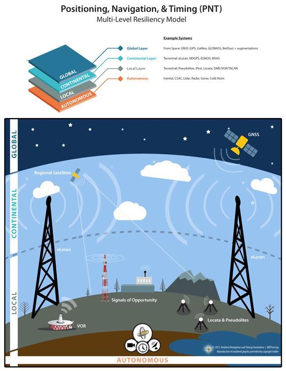
3 Coverage. As illustrated in the graphic at the end of these comments, a multi-layer model provides the best PNT resiliency. eloran complements GPS/GNSS global coverage, provides continental PNT coverage, and complements or enables local PNT coverage. The system should be as ubiquitous as possible as emergency services are required to operate in every portion of the US, including its navigable waters and Exclusive Economic Zone. (d) willingness to equip with an eloran receiver to reduce or prevent operational and/or economic consequences from a GPS disruption, Note: Our interaction with receiver manufacturers causes us to believe this question to be irrelevant except for the first few years of an eloran system s operation. Once an eloran system is in operation and receivers are in wide production, the size, weight, power, and cost (SWAP-C) of the receivers will decrease dramatically. We expect most commercial grade navigation receivers to be multi-mode, having the capability to receive GPS/GNSS and Loran/eLoran. Many receivers might also include inertial, gyro, CSAC, and/or barometric altimeters. Thus it will not be a matter of a user s willingness to equip, but rather that the market will be automatically equipping the user. As one manufacturer expressed it: Except for niche applications, building GPS-only receivers wouldn t make sense. Emergency services organizations find the ability to navigate in areas not currently accessible without pre-installed infrastructure very appealing. These areas include caves, tunnels, subbasements and other subterranean areas, urban and natural canyons, other areas without a good view of the sky, and underwater locations. Also very appealing is the ability to send messages to locations indoors, underground and underwater, and to remote and wilderness areas that have minimal infrastructure. Such a capability could be a valuable safety and command and control feature not available with any system now available. By way of example, if eloran navigation and communications had been available for emergency services during the wildfires of 2013, it could have provided a guaranteed communications path and navigation tool to direct to safety the 19 firefighters who were lost in Arizona. 8 (e) current and planned availability of e-loran capable user equipment, Loran-C and/or Chayka user equipment is now produced by the governments of China and Russia for internal consumption and use with their national systems. Outside of those countries, Loran- C and eloran receivers are produced in limited quantities, on demand. RNT Foundation discussions with several large receiver manufacturers have indicated that they would readily pursue development of integrated receivers that include eloran capability if there were Government support for the provision of eloran service. The estimated economic order quantity for these vendors is approximately 100,000, although the number of units depends upon the market sector served. Also, once this level of production has been achieved, the size of receivers 8 3
4 will undoubtedly be reduced to be compatible with many mobile devices, and the price per unit will drop dramatically (as was the case with GPS technology). The US Army has extensive information on this as a result of a recent RFI for 50,000 eloran receivers. (f) other non-eloran PNT technologies or operational procedures, currently available or planned, that could be used during a disruption of GPS for longer than a day. Sidebar: In 2011, Mr. James Caverly, at that time working for the DHS Office of Infrastructure Protection, reported on the department s GPS Critical Infrastructure Timing Study: Usage/Loss Impacts/Backups/Mitigation. This report has never been made public, to our knowledge. A publicly released presentation based on the report provides information about requirements and backup systems for all critical infrastructure sectors and cites the situation generally as worsening. 9 We know of no other technologies or operational procedures that could take the place of the unique ways in which GPS is used by the Emergency Services Sector. Offenders being remotely monitored would have to be taken into physical custody, situational awareness for incident responses would have to be created through voice reports, if radio communications were still functioning, and responders would have to navigate to the scene using maps and relying on voice reports to attempt to avoid congestion and find the quickest route. Explanatory Notes: 1. The Resilient Navigation and Timing Foundation (RNTF): RNTF is a scientific and educational 501(c)3 non-profit dedicated to helping protect critical infrastructure through (a) stronger laws and better enforcement against jamming and spoofing of GNSS signals, and (b) encouraging strong, difficult-to-disrupt terrestrial systems to complement and provide additional resilience for GNSS. Our corporate membership includes providers of a broad spectrum of PNT services from development of GPS satellites, to local and indoor positioning systems, and wide area low frequency systems, and some of the world s leading navigation associations. Individual members are concerned citizens and PNT professionals from academia, industry and government. 2. The Reason We Are Providing These Comments: Our nation s increasing reliance on GPS location and timing information for a very broad spectrum of technologies represents, in the words of Dr. Brad Parkinson, a single point of failure for much of America We believe that national effort to provide and encourage adoption of diverse 9 4
5 sources of location and timing information, provided by both federal and private entities, are essential to our national and economic security. We believe responses to this request for comment may be limited by individual companies reluctance to air their vulnerabilities or the perception that they would be revealing proprietary information. 3. How These Comments Were Developed: 4. eloran: The information provided was developed in coordination with our members who have had extensive interaction with the critical infrastructure sector being addressed. Information available in the media, professional discussion sites and other open sources has also been included. The request for comment mentions in several places a possible eloran system. Such technology is not generally known in the United States, even though it was developed here. For purposes of this response, we presume that the eloran system mentioned is similar to the one in operation in the United Kingdom as recently described in a paper presented to the Institute of Navigation 10. With appropriate ASF corrections, this system s accuracy has been measured at less than 25 feet for location and less than 50 nanoseconds for timing. While we understand that the Dutch have improved on these results, the underlying system is still eloran. While most technologists agree that much better performance is possible with further system development, our presumption is that the system the government refers to is the one described in the referenced paper. 5. The Importance of Quickly Implementing a Complementary System for GPS We are unable to improve upon the 2004 Presidential National Security Directive 39 issued by President Bush and affirmed by President Obama that identified GPS as essential to our national economy and national security, and mandated acquisition of a back-up system though we agree that a more appropriate descriptor would be complementary system. Since 2004 threats to GPS have increased, as have the number of disruptive incidents per day. The threats range from fleeting local disruptions such as might be caused by a private citizen passing by with an illegal Personal Privacy Device, to a global outage resulting from malicious intervention or simple human error. GPS is currently being modernized and made more resilient. It is also being joined by other modern systems, including Galileo (Europe), Beidou (China), QZSS (Japan), INRNSS (India). GLONASS (Russia) is being upgraded over a longer time period to include digitally modulated signals. These have certain resilience features for GPS. These are all positive developments that should be continued in order to improve the overall resilience of our global PNT architecture
6 In April of last year, GLONASS, the Russian satellite navigation and timing system, experienced two unannounced outages, one of which lasted for eleven hours. If this were to happen to the GPS constellation, unless there were complementary systems, such as other GNSS or eloran, that users had adopted and which would prevent PNT service disruption, the impact to our critical infrastructure and economy would be widespread and serious. The larger question, beyond those that the Department of Transportation has posed in the Federal Register, is: What would happen to our CI/KR, to our nation, and to the daily lives of its citizens, should there be a 24-hour disruption of GPS for any reason? 6
7 7
Communications Sector. Use of Positioning, Navigation and Timing (PNT) Services
 Services") Communications Sector Use of Positioning, Navigation and Timing (PNT) Services These comments are based upon public and private assertions made by representatives of this Critical Infrastructure/Key Resource
Communications Sector Use of Positioning, Navigation and Timing (PNT) Services These comments are based upon public and private assertions made by representatives of this Critical Infrastructure/Key Resource
Information Technology Sector. Use of Positioning, Navigation and Timing (PNT) Services
 Services") Information Technology Sector Use of Positioning, Navigation and Timing (PNT) Services These comments are based upon public and private assertions made by representatives of this Critical Infrastructure/Key
Information Technology Sector Use of Positioning, Navigation and Timing (PNT) Services These comments are based upon public and private assertions made by representatives of this Critical Infrastructure/Key
Energy Sector. Use of Positioning, Navigation and Timing (PNT) Services
 Services") Energy Sector Use of Positioning, Navigation and Timing (PNT) Services These comments are based upon public and private assertions made by representatives of this Critical Infrastructure/Key Resource sector
Energy Sector Use of Positioning, Navigation and Timing (PNT) Services These comments are based upon public and private assertions made by representatives of this Critical Infrastructure/Key Resource sector
Transportation Systems Sector. Use of Positioning, Navigation and Timing (PNT) Services
 Services") Transportation Systems Sector Use of Positioning, Navigation and Timing (PNT) Services These comments are based upon public and private assertions made by representatives of this Critical Infrastructure/Key
Transportation Systems Sector Use of Positioning, Navigation and Timing (PNT) Services These comments are based upon public and private assertions made by representatives of this Critical Infrastructure/Key
Canadian Coast Guard Review to Implement a Resilient Position, Navigation and Timing Solution for Canada. Mariners Workshop January 31 st, 2018
 Canadian Coast Guard Review to Implement a Resilient Position, Navigation and Timing Solution for Canada Mariners Workshop January 31 st, 2018 Outline Overview of GNSS use in the marine sector CCG Activities
Protection Augmentation Toughness and Alternatives of GNSS. Melaha 2016 Concord Al-Salam Hotel Cairo, April 25,2016 Refaat Rashad
 Protection Augmentation Toughness and Alternatives of GNSS Melaha 2016 Concord Al-Salam Hotel Cairo, April 25,2016 Refaat Rashad Road Map of the Presentation 1- How Good are GNSS 2- How Vulnerable are
School of Civil & Environmental Engineering, UNSW, Sydney, Australia. Chris Rizos. President Australian Institute of Navigation
 The Threat to Space Based Service (for PNT applications) School of Civil & Environmental Engineering, UNSW, Sydney, Australia Chris Rizos President Australian Institute of Navigation Outline GNSS... a
Extreme space weather: Geomagnetic storms, GNSS disruptions and the impact on vital functions in society
 Extreme space weather: Geomagnetic storms, GNSS disruptions and the impact on vital functions in society Fredrik Marsten Eklöf FOI, Informationssystem fredrik.eklof@foi.se, 0709-277426 Global Navigation
Experience with Radio Navigation Satellite Service (RNSS)
") Experience with Radio Navigation Satellite Service (RNSS) International Satellite Communication Symposium International Telecommunication Union (ITU) Geneva, 13-14 June 2016 MITOME, Takahiro Co-Chair of
Experience with Radio Navigation Satellite Service (RNSS) International Satellite Communication Symposium International Telecommunication Union (ITU) Geneva, 13-14 June 2016 MITOME, Takahiro Co-Chair of
Note that MIFD II will also be influencing standards in the US.
 1 2 Why should the Financial Sector care? Note that MIFD II will also be influencing standards in the US. The best contingency solutions is one that includes a Resilience Triad : GPS/GNSS, eloran, and
The Politics of Resilience Speaking Truth to Power the Last 18 Months
 The Politics of Resilience Speaking Truth to Power the Last 18 Months APRIL 2017 Workshop On Synchronization & Timing a single point of failure December 2015 US increasingly at risk from disruption 2011
Briefing for NPSTC DHS SCIENCE AND TECHNOLOGY 2017 FIRST RESPONDER ELECTRONIC JAMMING EXERCISE. September 6, 2017
 DHS SCIENCE AND TECHNOLOGY Briefing for NPSTC 2017 FIRST RESPONDER ELECTRONIC JAMMING EXERCISE September 6, 2017 Sridhar Kowdley Program Manager First Responders Group Science and Technology Directorate
CLICK HERE TO KNOW MORE
 CLICK HERE TO KNOW MORE Should GNSS Become a National Critical Infrastructure? Ooi Wei Han, Noordin Ahmad, Shahrizal IM National Space Agency (ANGKASA) Ministry of Science, Technology and Innovation (MOSTI)
GPS jamming
 Page 1 of 5 GPS jamming No jam tomorrow Navigation: As the uses of satellite-positioning technology continue to grow, what can be done to stop deliberate and dangerous jamming of the signals? Mar 10th
GPS Interference Detection & Mitigation
 GPS Interference Detection & Mitigation GAARDIAN GNSS AVAILABILITY ACCURACY RELIABILITY and INTEGRITY ASSESSMENT for TIMING and NAVIGATION A Technology Strategy Board funded collaboration Charles Curry,
GPS Evidence - Where s It Taking Us?
 GPS Evidence - Where s It Taking Us? Professor David Last International Communications Data & Digital Forensics Seminars 17-21 March 2014 Picture: earthobservatory.nasa. gov//ewsroom/bluemarble/ David
Update from the United States Space-Based Positioning, Navigation, and Timing Advisory Board
 Update from the United States Space-Based Positioning, Navigation, and Timing Advisory Board John W. Betz, PhD PNTAB Member Presented to ICG-12, Kyoto, Japan December 2017 Approved for Public Release;
GNSS Threats at Airports and detecting them
 GNSS Threats at Airports and detecting them Guy Buesnel, Romain Zimmermann, October 2017 Overview of Spirent Positioning and Timing Mobile Devices Military Applications Commercial Air Travel Automotive
The U.S. government appears
 The U.S. government appears to be closing in on a decision about whether to revive plans for an enhanced Loran (eloran) system, as a backup for the position, navigation, and timing (PNT) information provided
Jamming and Spoofing of GNSS Signals An Underestimated Risk?!
 Jamming and Spoofing of GNSS Signals An Underestimated Risk?! Alexander Rügamer Dirk Kowalewski Fraunhofer IIS NavXperience GmbH Fraunhofer IIS 1 Source: http://securityaffairs.co/wordpress/wpcontent/uploads/2012/02/spoofing.jpg
Surviving and Operating Through GPS Denial and Deception Attack. Nathan Shults Kiewit Engineering Group Aaron Fansler AMPEX Intelligent Systems
 Surviving and Operating Through GPS Denial and Deception Attack Nathan Shults Kiewit Engineering Group Aaron Fansler AMPEX Intelligent Systems How GPS Works GPS Satellite sends exact time (~3 nanoseconds)
eloran Points of Light
 There is considerable misinformation, outdated information, and obviously misleading information being promulgated as fact about Enhanced Loran (eloran). This Points of Light paper is intended to respond
Black Swans, White Elephants and Delivering a New National Timescale with eloran
 Black Swans, White Elephants and Delivering a New National Timescale with eloran Charles Curry BEng, CEng, FIET Managing Director Chronos Technology Ltd SFR, Paris 18 th July 2014 PNT First Experiences
Leadership in Resilient PNT
 www.ursanav.com www.nautelnav.com 29 November 2017 Leadership in Resilient PNT The Need for Resilient PNT Position, Navigation, and Timing, or PNT, is known as the hidden utility. Despite its widespread
European GNSS Evolution
 Ref. Ares(204)902599 - /06/204 European GNSS Evolution Hermann Ebner Galileo and EGNOS Programme Management DG Enterprise and Industry Content Introduction 2 2 Major Challenges for EGNSS Evolution 3 EGNSS
eloran Points of Light
 There is considerable misinformation, outdated information, and obviously misleading information being promulgated as fact about Enhanced Loran (eloran). This Points of Light paper is intended to respond
Providing a Resilient Timing and UTC Service Using eloran in the United States
 Providing a Resilient Timing and UTC Service Using eloran in the United States Gerard Offermans, Steve Bartlett, Charles Schue, UrsaNav, Inc. BIOGRAPHIES Dr. Gerard Offermans is Senior Research Scientist
Alternative Positioning, Navigation, Timing, and Data for Korea and the World
 Shared interest in a more productive tomorrow. Alternative Positioning, Navigation, Timing, and Data for Korea and the World Prepared by: Mr. Charles Schue, President & CEO ILA40 / KIN November 17, 2011
Three Wishes. and an elaboration. For Reception of. Professor Bradford Parkinson Stanford University. (these are my personal views)
") Three Wishes and an elaboration For Reception of Professor Bradford Parkinson Stanford University (these are my personal views) Three Wishes - Dr, Parkinson 2017 1 Good News: World-wide dependency on GNSS
Three Wishes and an elaboration For Reception of Professor Bradford Parkinson Stanford University (these are my personal views) Three Wishes - Dr, Parkinson 2017 1 Good News: World-wide dependency on GNSS
U.S. Perspectives on eloran as a Timing Backup And Available Hardware. Charles Schue UrsaNav, Inc. KTN Trinity House October 8, 2012
 U.S. Perspectives on eloran as a Timing Backup And Available Hardware Charles Schue UrsaNav, Inc. KTN Trinity House October 8, 2012 Corporate Overview Chesapeake, Virginia, USA Founded in 2004 Four main
A Holistic Approach to Trusted, Resilient PNT: GNSS, STL and eloran
 A Holistic Approach to Trusted, Resilient PNT: GNSS, STL and eloran John Fischer, Vice President of Research & Development, Orolia Dr. Michael O Connor, CEO, Satelles Charles Schue, CEO, UrsaNav With an
Geoscience & Positioning, Navigation and Timing Services for Canadians
 Geoscience & Positioning, Navigation and Timing Services for Canadians Calvin Klatt, Ph.D. Director and Chief Geodesist Natural Resources Canada / Directeur et géodésien principal Ressources naturelles
Resilience through co-primary PNT solutions: GPS and eloran. By Charles Schue September 4, 2014
 1 Resilience through co-primary PNT solutions: GPS and eloran By Charles Schue September 4, 2014 Outline The Problem: Vulnerabilities The Need: Resilience The Solution: Co-Primary GPS and eloran eloran
Providing a Resilient Timing and UTC Service Using eloran in the United States. Charles Schue - ION PTTI Monterey, CA
 Providing a Resilient Timing and UTC Service Using eloran in the United States Charles Schue - ION PTTI Monterey, CA January 27, 2016 Motivation For a Resilient Timing and UTC Service GPS/GNSS Vulnerabilities
RESPONSE TO THE HOUSE OF COMMONS TRANSPORT SELECT COMMITTEE INQUIRY INTO GALILEO. Memorandum submitted by The Royal Academy of Engineering
 RESPONSE TO THE HOUSE OF COMMONS TRANSPORT SELECT COMMITTEE INQUIRY INTO GALILEO Memorandum submitted by The Royal Academy of Engineering September 2004 Executive Summary The Royal Academy of Engineering
The Effect of Radio Frequency Interference on GNSS Signals and Mitigation Techniques Presented by Dr. Tarek Attia
 International Conference and Exhibition Melaha2016 GNSS WAY Ahead 25-27 April2016, Cairo, Egypt The Effect of Radio Frequency Interference on GNSS Signals and Mitigation Techniques Presented by Dr. Tarek
Navigati. GNSS Resilience. The Magazine of the Royal Institute of Navigation MAY/JUN Resilience Has A Name Its name is eloran
 Navigati MAY/JUN 2014 5.00 The Magazine of the Royal Institute of Navigation GNSS Resilience The Navigation of Navigation How we got to where we are with GNSS Resilience Has A Name Its name is eloran The
S a t e l l i t e T i m e a n d L o c a t i o n. N o v e m b e r John Fischer VP Advanced R&D
 STL - S a t e l l i t e T i m e a n d L o c a t i o n N o v e m b e r 2 0 1 7 John Fischer VP Advanced R&D jfischer@orolia.com 11/28/201 1 7 WHY AUGMENT GNSS? Recent UK Study Economic Input to UK of a
PROTECTING GPS/GNSS-RELIANT MILITARY SYSTEMS
 PROTECTING GPS/GNSS-RELIANT MILITARY SYSTEMS John Fischer VP Advanced R&D Jon Sinden Product Manager, Rugged PNT 6/21/2018 ABOUT OROLIA A world leader in assured positioning, navigation and timing (PNT)
Implementing a Wide Area High Accuracy UTC Service via eloran
 Implementing a Wide Area High Accuracy UTC Service via eloran ION PTTI, Boston, MA December 3, 2014 Dr. Gerard Offermans Overview Basis for consideration of eloran as a source of precise time, frequency,
The Navigation of Navigation
 The Navigation of Navigation Professor David Last Past-President, Royal Institute of Navigation jdl@navaid.demon.co.uk Abstract Satellite navigation is an exceptionally successful technology. It benefits
GNSS VULNERABILITY AND CRITICAL INFRASTRUCTURE
 GNSS VULNERABILITY AND CRITICAL INFRASTRUCTURE NNF CONFERENCE 24 MAY 2012 Brynjar Hansen Senior adviser Norwegian Space Centre Lars Giske Senior adviser Norwegian Space Centre MULTI GNSS EXTERNAL COOPERATION
GE 113 REMOTE SENSING
 GE 113 REMOTE SENSING Topic 9. Introduction to Global Positioning Systems (GPS) and Other GNSS Technologies Lecturer: Engr. Jojene R. Santillan jrsantillan@carsu.edu.ph Division of Geodetic Engineering
GPS & other Radio Time sources
 GPS & other Radio Time sources Anthony Flavin, MIET Chronos Technology Ltd Wireless Heritage SIG Time for Telecoms British Science Museum Friday 16th April 2018 Chronos Technology: COMPANY PROPRIETARY
Wide Area Time distribution Via eloran. NASPI WG Meeting
 Wide Area Time distribution Via eloran NASPI WG Meeting March 22 2017 This work is supported through a Cooperative Research and Development Agreement (CRADA) with the Department of Homeland Security (DHS)
GPS + Glonass Using the Best of Both Worlds
 GPS + Glonass Using the Best of Both Worlds Jupiter SL869 Jupiter JN3 Jupiter SE880 IMPROVE TIME-TO-FIRST-FIX GET MORE ACCURATE POSITIONING ENHANCE TIME IN NAVIGATION COLLECT MOST RELIABLE PROBE-DATA TABLE
European GNSS: Galileo and EGNOS for next generation Road Charging
 European GNSS: Galileo and EGNOS for next generation Road Charging 20 th October 2014 Gian Gherardo Calini European GNSS Agency (GSA) GNSS have made a huge impact in our society it is key in Road transportation
PRIORITIZING DANGERS TO THE UNITED STATES FROM THREATS TO GPS
 PRIORITIZING DANGERS TO THE UNITED STATES FROM THREATS TO GPS Ranking Risks and Proposed Mitigations GPS-III, www.gps.gov WHITE PAPER This paper examines risks to the United States, its Global Positioning
GPS Jamming and its impact on maritime navigation
 GPS Jamming and its impact on maritime navigation Dr Alan Grant Research and Development - Special Interest Group 10 th May 2010 Use of GPS in the maritime sector GPS has become the normal means for maritime
Design and Performance of a Low Frequency Time and Frequency Dissemination Service
 Design and Performance of a Low Frequency Time and Frequency Dissemination Service Dr. Arthur Helwig, Dr. Gerard Offermans, Chris Stout, Charles Schue, UrsaNav, Inc. BIOGRAPHIES Dr. Arthur Helwig is a
European Radio Navigation Plan. Gilles LEQUEUX, European Commission Policy Development and Strategies
 European Radio Navigation Plan Gilles LEQUEUX, European Commission Policy Development and Strategies CONTEXT - BENEFITS Space Strategy for Europe Introduction of EGNSS in EU sectoral policies Better strategic
PRELIMINARY PROGRAMME
 ICG EXPERTS MEETING: GLOBAL NAVIGATION SATELLITE SYSTEMS SERVICES 14-18 December 2015 Vienna International Centre, Vienna, Austria Organized by International Committee on Global Navigation Satellite Systems
White Paper. GPS Jamming. Increasing system resilience to counteract intentional and unintentional GPS signal interferences
 White Paper GPS Jamming Increasing system resilience to counteract intentional and unintentional GPS signal interferences Mark Hendrick, Engineering Program Manager 07/2011 1474-002 RevA White Paper GPS
ELECTRONIC BULLETIN For information only
 International Civil Aviation Organization ELECTRONIC BULLETIN For information only EB 2011/56 AN 7/5 21 November 2011 INTERFERENCE TO GLOBAL NAVIGATION SATELLITE SYSTEM (GNSS) SIGNALS 1. Aviation operations
Timing & Synchronisation
 Timing & Synchronisation With an analysis of GNSS User Technology ISSUE 4 Excerpt from the GNSS MARKET REPORT, ISSUE 4 (2015) 72 Timing & Synchronisation GNSS applications This chapter addresses the following
Developing a GNSS resiliency framework for timing receivers. By Guy Buesnel and Adam Price Spirent Communications, October 2017
 Developing a GNSS resiliency framework for timing receivers By Guy Buesnel and Adam Price, October 2017 Overview of Spirent Positioning and Timing Mobile Devices Military Applications Commercial Air Travel
Global Positioning Systems Directorate
 Space and Missile Systems Center Global Positioning Systems Directorate GPS Program Update to 8 th Stanford PNT Symposium 30 Oct 2014 Col Matt Smitham Deputy Director, GPS Directorate Global Positioning
COMMUNICATIONS FOR MARITIME SAFETY AND EFFICIENCY. Francis Zachariae, Secretary-General, IALA
 COMMUNICATIONS FOR MARITIME SAFETY AND EFFICIENCY Francis Zachariae, Secretary-General, IALA IALA and its Purpose Non profit, international technical association established in 1957 Two Goals aimed at
4G Broadband: Bridging to Public Safety Land Mobile Networks
 Andrew Seybold, Inc., 315 Meigs Road, A-267, Santa Barbara, CA 93109 805-898-2460 voice, 805-898-2466 fax, www.andrewseybold.com 4G Broadband: Bridging to Public Safety Land Mobile Networks June 2, 2010
Ensuring Robust Precision Time: Hardened GNSS, Multiband, and Atomic Clocks. Lee Cosart WSTS 2018
 Power Matters. Ensuring Robust Precision Time: Hardened GNSS, Multiband, and Atomic Clocks Lee Cosart lee.cosart@microsemi.com WSTS 2018 Outline Introduction The Challenge Time requirements increasingly
Black Swans and White Elephants GPS Jamming and Resilient PNT
 Black Swans and White Elephants GPS Jamming and Resilient PNT Charles Curry BEng, CEng, FIET Managing Director Chronos Technology Ltd ITSF 2014 4-6 th Nov 2014 Budapest, Hungary Black Swan Events Nassim
DARPA developing Very Low Frequency (VLF) systems to provide GPS like position and timing technologies
 systems to provide GPS like position and timing technologies") DARPA developing Very Low Frequency (VLF) systems to provide GPS like position and timing technologies in contested, underwater and underground Environments The GPS system provides critical positioning
DARPA developing Very Low Frequency (VLF) systems to provide GPS like position and timing technologies in contested, underwater and underground Environments The GPS system provides critical positioning
02 Issue. e-navigation News. GNSS Vulnerability. Dublin Bay Digital Diamond. e-navigation. Demonstrator Update International. e-navigation.
 CORPORATE SECURITY TEAMWORK EVENTS 02 Issue e-navigation News GNSS Vulnerability Dublin Bay Digital Diamond e-navigation Demonstrator Update International e-navigation update June 2014 www.cil.ie +353
Understanding and Mitigating Global Positioning System (GPS) Vulnerabilities
 Vulnerabilities") Understanding and Mitigating Global Positioning System (GPS) Vulnerabilities Issue: Increasing US military dependence on GPS may lead to a single point of failure if vulnerabilities are not understood
Understanding and Mitigating Global Positioning System (GPS) Vulnerabilities Issue: Increasing US military dependence on GPS may lead to a single point of failure if vulnerabilities are not understood
Results from a GPS Timing Criticality Assessment
 Results from a GPS Timing Criticality Assessment European Navigation Conference, GNSS 2008 Session 2b - Timing James Carroll, DOT/RITA Volpe Center April 2008 Introduction Timing Criticality Assessment
White paper March UrgentLink DISASTER COMMUNICATIONS NETWORK
 White paper March 2018 UrgentLink DISASTER COMMUNICATIONS NETWORK Background Tragedies such as September 11, Hurricane Katrina and more recently Hurricane Harvey, Hurricane Maria, and the California wildfires
ASSEMBLY 37TH SESSION
 International Civil Aviation Organization WORKING PAPER A37-WP/195 1 22/9/10 (Information paper) ASSEMBLY 37TH SESSION TECHNICAL COMMISSION Agenda Item 35: The Global Air Traffic Management (ATM) System
Report of the Working Group B: Enhancement of Global Navigation Satellite Systems (GNSS) Services Performance
 Services Performance") Report of the Working Group B: Enhancement of Global Navigation Satellite Systems (GNSS) Services Performance 1. The Working Group on Enhancement of Global Navigation Satellite Systems (GNSS) Service Performance
Report of the Working Group B: Enhancement of Global Navigation Satellite Systems (GNSS) Services Performance 1. The Working Group on Enhancement of Global Navigation Satellite Systems (GNSS) Service Performance
Applying Defence-in-depth to counter RF interferences over GNSS
 Applying Defence-in-depth to counter RF interferences over GNSS IET 5th Oct. 2011 Xavier Bertinchamps - GSA Objective of this presentation Understand Jamming threat on GNSS Propose a comprehensive strategy
GLOBAL POSITIONING SYSTEMS. Knowing where and when
 GLOBAL POSITIONING SYSTEMS Knowing where and when Overview Continuous position fixes Worldwide coverage Latitude/Longitude/Height Centimeter accuracy Accurate time Feasibility studies begun in 1960 s.
Three Wishes - Dr, Parkinson
 Three Wishes - Dr, Parkinson 2017 1 Three Wishes and an elaboration For Reception of Professor Bradford Parkinson Stanford University (these are my personal views) Three Wishes - Dr, Parkinson 2017 2 Good
Space and Missile Systems Center
 Space and Missile Systems Center Global Positioning Systems Directorate GPS Status & Modernization Progress: Service, Satellites, Control Segment, and Military GPS User Equipment 3 Nov 2016 Col Steve Whitney,
GPS Jamming Quantifying the Threat
 GPS Jamming Quantifying the Threat GNSS Vulnerability Countering the Threat 13 th Feb 2013 Prof. Charles Curry B.Eng, C.Eng, FIET Managing Director Chronos Technology Ltd NPL, Teddington, London Presentation
Victor Cid Senior Computer Scientist DIMRC, SIS, NLM
 Victor Cid Senior Computer Scientist DIMRC, SIS, NLM Patient arrives to Walter Reed NMMC Patient transferred to Suburban voice repot made from WRNMMC radio to Suburban cell phone via wireless bridge 2
Where Next for GNSS?
 Where Next for GNSS? Professor Terry Moore Professor of Satellite Navigation Nottingham The University of Nottingham Where Next for GNSS Back to the Future? Professor Terry Moore Professor of Satellite
Lecture-1 CHAPTER 2 INTRODUCTION TO GPS
 Lecture-1 CHAPTER 2 INTRODUCTION TO GPS 2.1 History of GPS GPS is a global navigation satellite system (GNSS). It is the commonly used acronym of NAVSTAR (NAVigation System with Time And Ranging) GPS (Global
GLObal Navigation Satellite System (GLONASS)
") FEDERAL SPACE AGENCY GLObal Navigation Satellite System (GLONASS) Sergey Revnivykh Deputy Director General Central Research Institute of Machine Building Head of PNT Center 4-th meeting of International
FEDERAL SPACE AGENCY GLObal Navigation Satellite System (GLONASS) Sergey Revnivykh Deputy Director General Central Research Institute of Machine Building Head of PNT Center 4-th meeting of International
MDTS 5734 : Guidance Lecture 5 : Global Positioning Systems. Gerard Leng, MDTS, NUS
 MDTS 5734 : Guidance Lecture 5 : Global Positioning Systems Question : What do we really need for trans-continental navigation? Hint below : It s not GPS!?! First London to Singapore flight by Imperial
3 4 1: 2: SAFECOM : 4: 5: 6: 7: IP
 Texas Radio Communications Interoperability Plan 1 TABLE OF CONTENTS Introduction... 3 Levels of Interoperability... 4 Figure 1: Six Levels of Interoperability... 4 Figure 2: SAFECOM Interoperability Continuum...
Does Anyone Really Know What Time It Is? Dr. Michael L. Cohen, MITRE October 15, 2013
 Does Anyone Really Know What Time It Is? Dr. Michael L. Cohen, MITRE October 15, 2013 2013 The MITRE Corporation. All rights reserved Approved for Public Release; Distribution Unlimited 13-3392. The Problem:
Special Committee SC-159 Navigation Equipment Using the Global Navigation Satellite System (GNSS) (Version 13)
 (Version 13)") RTCA Paper No. 307-18/PMC-1839 December 13, 2018 TERMS OF REFERENCE Special Committee SC-159 Navigation Equipment Using the Global Navigation Satellite System (GNSS) (Version 13) REQUESTOR: Organization
RTCA Paper No. 307-18/PMC-1839 December 13, 2018 TERMS OF REFERENCE Special Committee SC-159 Navigation Equipment Using the Global Navigation Satellite System (GNSS) (Version 13) REQUESTOR: Organization
Report on GPS Jamming Trials and Criminal Use of Jammers
 Report on GPS Jamming Trials and Criminal Use of Jammers Prof. Charles Curry BEng, CEng, FIET Chronos Technology Ltd WSTS, San Jose, Tuesday 10 th March Session 2 Presentation Contents Background & Research
Challenges and Solutions for GPS Receiver Test
 Challenges and Solutions for GPS Receiver Test Presenter: Mirin Lew January 28, 2010 Agenda GPS technology concepts GPS and GNSS overview Assisted GPS (A-GPS) Basic tests required for GPS receiver verification
GPS Interference & Space Weather Real or Imagined Vulnerability?
 GPS Interference & Space Weather Real or Imagined Vulnerability? Prof. Charles Curry B.Eng, FIET Managing Director Chronos Technology Ltd 7 th Nov 2012 ITSF Nice, France Presentation Contents Background
GNSS Programme. Overview and Status in Europe
 GNSS Programme Overview and Status in Europe Inaugural Forum Satellite Positioning Research and Application Center 23 April 2007 Tokyo Presented by Thomas Naecke (European Commission) Prepared by Daniel
Special Committee SC-159 Navigation Equipment Using the Global Navigation Satellite System (GNSS) (Version 11)
 (Version 11)") RTCA Paper No. 094-18/PMC-1737 March 22, 2018 TERMS OF REFERENCE Special Committee SC-159 Navigation Equipment Using the Global Navigation Satellite System (GNSS) (Version 11) REQUESTOR: Organization Person
RTCA Paper No. 094-18/PMC-1737 March 22, 2018 TERMS OF REFERENCE Special Committee SC-159 Navigation Equipment Using the Global Navigation Satellite System (GNSS) (Version 11) REQUESTOR: Organization Person
Latest Update on GPS Jamming & Susceptibility Trials
 Latest Update on GPS Jamming & Susceptibility Trials ITSF 2015, Edinburgh, Scotland 5 th November 2015 Charles Curry BEng, CEng, FIET Chronos Technology Ltd Presentation Contents Jamming Research Types
Webinar. 9 things you should know about centimeter-level GNSS accuracy
 Webinar 9 things you should know about centimeter-level GNSS accuracy Webinar agenda 9 things you should know about centimeter-level GNSS accuracy 1. High precision GNSS challenges 2. u-blox F9 technology
AEEC 2013 Presentation to the Airlines and the Aviation Industry
 AEEC 2013 Presentation to the Airlines and the Aviation Industry Multi-Frequency/Multi-Constellation (MFMC) GNSS Receivers Value for Aviation and Airlines John Studenny CMC GPS Product Manager Alain Beaulieu
The Next Generation of Secure Position, Navigation and Timing Technology
 Navigation and Timing Technology November 2017 Contents Executive Summary 2 GPS on the Battlefield 2 Vulnerabilities of GPS 2 Staying Ahead of the Threat 3 Innovating For More Resilient PNT 3 Innovative,
Making Military PNT Systems Resilient Against Threats: Recent Advances
 Making Military PNT Systems Resilient Against Threats: Recent Advances Spectracom White Paper By John Fischer, VP, Advanced R&D and Hendrik van Edig, Documentation Engineer Oct. 2017 Executive Summary
Potential areas of industrial interest relevant for cross-cutting KETs in the Electronics and Communication Systems domain
 This fiche is part of the wider roadmap for cross-cutting KETs activities Potential areas of industrial interest relevant for cross-cutting KETs in the Electronics and Communication Systems domain Cross-cutting
RECOMMENDATION ITU-R M.1310* TRANSPORT INFORMATION AND CONTROL SYSTEMS (TICS) OBJECTIVES AND REQUIREMENTS (Question ITU-R 205/8)
 OBJECTIVES AND REQUIREMENTS (Question ITU-R 205/8)") Rec. ITU-R M.1310 1 RECOMMENDATION ITU-R M.1310* TRANSPORT INFORMATION AND CONTROL SYSTEMS (TICS) OBJECTIVES AND REQUIREMENTS (Question ITU-R 205/8) Rec. ITU-R M.1310 (1997) Summary This Recommendation
Rec. ITU-R M.1310 1 RECOMMENDATION ITU-R M.1310* TRANSPORT INFORMATION AND CONTROL SYSTEMS (TICS) OBJECTIVES AND REQUIREMENTS (Question ITU-R 205/8) Rec. ITU-R M.1310 (1997) Summary This Recommendation
Interagency Working Group on Import Safety. Executive Order July 18, 2007
 Executive Order 13439 July 18, 2007 Establish an Interagency Working Group on Import Safety We need to continually improve our import safeguards to meet the changing demands of a global economy. We must
Current State-of-the-Art Tracking & Tracing Dr. Chaz Dixon, Telespazio VEGA UK Ltd. 31 st January 2018
 Current State-of-the-Art Tracking & Tracing Dr. Chaz Dixon, Telespazio VEGA UK Ltd 31 st January 2018 Overview Session 2: Waste Tracking via GNSS Current State-of-the-Art Tracking & Tracing Chaz Dixon,
«Current state and prospects of development of commercial application GLONASS/GNSS in the Russian Federation»
 «Current state and prospects of development of commercial application GLONASS/GNSS in the Russian Federation» United Nations SYMPOSIUM TO STRENGTHEN THE PARTNERSHIP WITH INDUSTRY COMMERCIAL APPLICATIONS
King AbdulAziz University. Faculty of Environmental Design. Geomatics Department. Mobile GIS GEOM 427. Lecture 3
 King AbdulAziz University Faculty of Environmental Design Geomatics Department Mobile GIS GEOM 427 Lecture 3 Ahmed Baik, Ph.D. Email: abaik@kau.edu.sa Eng. Fisal Basheeh Email: fbasaheeh@kau.edu.sa GNSS
APCO Technology Forum THE CONVERGENCE OF WIRELESS COMMUNICATIONS IN PUBLIC SAFETY. Andrew M. Seybold
 APCO Technology Forum THE CONVERGENCE OF WIRELESS COMMUNICATIONS IN PUBLIC SAFETY Andrew M. Seybold February 26, 2014 Some Terminology NPSBN Nationwide Public Safety Broadband Network LMR Land Mobile Radio
The Navigation of Navigation
 The Navigation of Navigation 2014 PNT Challenges & Opportunities Symposium Stanford University 29 October 2014 Professor David Last Past President, Royal Institute of Navigation Ladies and Gentlemen, Good
Global Navigation Satellite System for IE 5000
 Global Navigation Satellite System for IE 5000 Configuring GNSS 2 Information About GNSS 2 Guidelines and Limitations 4 Default Settings 4 Configuring GNSS 5 Configuring GNSS as Time Source for PTP 6 Verifying