Information Technology Sector. Use of Positioning, Navigation and Timing (PNT) Services
|
|
|
- Jack Lester
- 6 years ago
- Views:
Transcription
1 Information Technology Sector Use of Positioning, Navigation and Timing (PNT) Services These comments are based upon public and private assertions made by representatives of this Critical Infrastructure/Key Resource (CI/KR) sector and PNT subject matter experts that have examined such issues. Some members of CI/KR sectors might not provide public comment out of a desire to avoid disclosing vulnerabilities and/or proprietary information. Therefore, the RNT Foundation is providing this response for the public record on their behalf. See explanatory notes at the end of this document. GPS PNT services have been integrated into virtually every technology and are a critical to nearly every facet of life in America. As such, their impact on one sector very much impacts another. For example, the transportation and communications sectors both rely heavily on GPS, and all sectors rely heavily on transportation and communications. The comments in this response try to address only the ways in which GPS/ PNT services are uniquely used by this sector. These comments have been structured to respond as directly as possible to the questions posted in the Federal Register (bold italics below). (a) A brief description of your application(s) of positioning, navigation, and timing services; A primary use of PNT by the IT sector is related to its dependence on wireless and fiber networks. These uses are addressed in another submission to the docket discussing the Communications Sector. 1. Time stamps for Distributed (Cloud) Data Data storage in multiple dispersed physical locations requires that all versions of data be time stamped so that the latest refresh can be identified and previous versions be archived. Google s global Spanner data base, for example, uses GPS and atomic clocks for time stamping, but even then operations have to slow down temporarily in order to resolve time uncertainty Computing in Distributed Systems 2 (footnoted reference quoted directly) a. Time can define order across a system (without communication) The order of events is important in distributed systems, because many properties of distributed systems are defined in terms of the order of operations/events: where correctness depends on (agreement on) correct event ordering, for example serializability in a distributed database order can be used as a tie breaker when resource contention occurs, for example if there are two orders for a widget, fulfill the first and cancel the second one
2 A global clock would allow operations on two different machines to be ordered without the two machines communicating directly. Without a global clock, we need to communicate to be able to determine order. b. Time can also be used to define boundary conditions for algorithms - specifically, to distinguish between "high latency" and "server or network link is down". This is a very important use case; in most real-world systems timeouts are used to determine whether a remote machine has failed, or whether it is simply experiencing high network latency. Algorithms that make this determination are called failure detectors 3. Location data to support services Location data is heavily used in numerous applications to better support services to individual and corporate users. People are corporal beings and exist in physical space. The places and things around them are of exceptional importance. Pushed information (advertisements, subscriptions, etc.) and pulled information (response to a user s requests) frequently require the user s location to be relevant. 4. Orientation/compass in applications. Most smartphones and vehicle navigation systems include a compass function. In many cases, this capability relies on GPS. Further, the user must be in motion for the compass to work. 5. Geoencryption / Geofencing Geoencryption 3 is an enhancement to traditional encryption that makes use of location or time as a mean to produce additional security and security features. It denies decryption of information or use of a device to users who do not appear to be in an approved location and/or time. For example, an entertainment company may use location to enable or prevent a mobile device ability to stream live video of a sporting event. 6. Proof of time and location as part of identity Similar to geoencryption, location and time are used to help verify a user s identity for remote applications. 7. General Comment excerpted from National Institute of Standards and Technology Technical Note 1867 (February 2015) : A new economy built on the massive growth of endpoints on the internet will require precise and verifiable timing in ways that current systems do not support. Applications, computers, and communications systems have been developed with modules and layers that optimize data processing but degrade accurate timing. State-of-the-art systems now use timing only as a performance metric. Correctness of timing as a metric cannot currently be designed into systems independent of hardware and/or software implementations. To enable the massive growth predicted, accurate timing needs cross-disciplinary research to be integrated into these existing systems
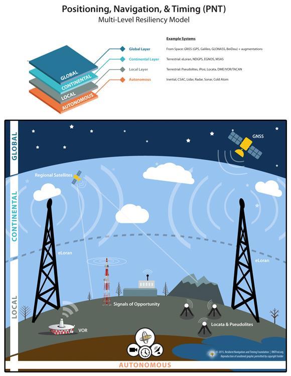
3 (b) the positioning, navigation, and/or timing performance required for a complementary PNT capability to support operations during a disruption of GPS that could last for longer than a day, To qualify as a complementary system, a new PNT capability would need to: 1. Provide very wide area, precise, wireless location and timing services. The timing signal would need to be synchronized with UTC (and therefore GPS, when in it is in operation) and location information would have to correspond to that obtained from GPS as closely as possible. 2. Have features and/or capabilities not available with GPS. Without such it would be a duplicate or redundant service, vice complementary. Desired features for specialpurpose users, such as First Responders and the military, include a signal that is usable under foliage, underground (i.e., garages), indoors and that has a robust, securitycapable, data channel for differential corrections and other information. 3. Likely remain functioning in situations when GPS is disrupted. The complementary system should have different signal characteristics, and therefore different failure modes, than GPS. These include a signal that is terrestrial based, high power and in a frequency band far distant from that of GPS. Material published in 2012 about Google s Spanner data base shows a need to limit time uncertainty to 10 milliseconds. 4 The requirement now may be much greater. (c) availability and coverage area required for a complementary PNT capability, Availability. Any system intended to complement GPS should have the same availability as the GPS system. Coverage. As illustrated in the graphic a the end of these comments, a multi-layer model provides the best PNT resiliency. eloran complements GPS/GNSS global coverage, provides continental PNT coverage, and complements or enables local PNT coverage. The system should be as ubiquitous as possible as information technology is becoming increasingly mobile. (d) willingness to equip with an eloran receiver to reduce or prevent operational and/or economic consequences from a GPS disruption, Note: Our interaction with receiver manufacturers causes us to believe this question to be irrelevant except for the first few years of an eloran system s operation. Once an eloran system is in operation and receivers are in wide production, the size, weight, power, and cost (SWAP-C) of the receivers will decrease dramatically. We expect most commercial grade navigation receivers to be multi-mode, having the capability to receive GPS/GNSS and Loran/eLoran. Many receivers might also include inertial, gyro, CSAC, and/or barometric altimeters. Thus it will not be a matter of a user s willingness to equip, but rather that the market will be automatically 4 3
4 equipping the user. As one manufacturer expressed it: Except for niche applications, building GPS-only receivers wouldn t make sense. (e) current and planned availability of e-loran capable user equipment, Loran-C and/or Chayka user equipment is now produced by the governments of China and Russia for internal consumption and use with their national systems. Outside of those countries, Loran- C and eloran receivers are produced in limited quantities, on demand. RNT Foundation discussions with several large receiver manufacturers have indicated that they would readily pursue development of integrated receivers that include eloran capability if there were Government support for the provision of eloran service. The estimated economic order quantity for these vendors is approximately 100,000, although the number of units depends upon the market sector served. Also, once this level of production has been achieved, the size of receivers will undoubtedly be reduced to be compatible with many mobile devices, and the price per unit will drop dramatically (as was the case with GPS technology). The US Army has extensive information on this as a result of a recent RFI for 50,000 eloran receivers. (f) other non-eloran PNT technologies or operational procedures, currently available or planned, that could be used during a disruption of GPS for longer than a day. Sidebar: In 2011, Mr. James Caverly, at that time working for the DHS Office of Infrastructure Protection, reported on the department s GPS Critical Infrastructure Timing Study: Usage/Loss Impacts/Backups/Mitigation. This report has never been made public, to our knowledge. A publicly released presentation based on the report provides information about requirements and backup systems for all critical infrastructure sectors and cites the situation generally as worsening. 5 The information technology industry uses a variety of atomic clocks and network timing to supplement GPS time. Most GPS location services on mobile devices are supplement by a variety of ranging and other signals to improve accuracy, especially for indoors locations. These supplemental signals will not likely be available during an extended GPS outage lasting a day or more. Explanatory Notes: 1. The Resilient Navigation and Timing Foundation (RNTF): RNTF is a scientific and educational 501(c)3 non-profit dedicated to helping protect critical infrastructure through (a) stronger laws and better enforcement against jamming and spoofing of GNSS signals, and (b) encouraging strong, difficult-to-disrupt terrestrial systems to complement and provide additional resilience for GNSS
5 Our corporate membership includes providers of a broad spectrum of PNT services from development of GPS satellites, to local and indoor positioning systems, and wide area low frequency systems, and some of the world s leading navigation associations. Individual members are concerned citizens and PNT professionals from academia, industry and government. 2. The Reason We Are Providing These Comments: Our nation s increasing reliance on GPS location and timing information for a very broad spectrum of technologies represents, in the words of Dr. Brad Parkinson, a single point of failure for much of America We believe that national effort to provide and encourage adoption of diverse sources of location and timing information, provided by both federal and private entities, are essential to our national and economic security. We believe responses to this request for comment may be limited by individual companies reluctance to air their vulnerabilities or the perception that they would be revealing proprietary information. 3. How These Comments Were Developed: 4. eloran: The information provided was developed in coordination with our members who have had extensive interaction with the critical infrastructure sector being addressed. Information available in the media, professional discussion sites and other open sources has also been included. The request for comment mentions in several places a possible eloran system. Such technology is not generally known in the United States, even though it was developed here. For purposes of this response, we presume that the eloran system mentioned is similar to the one in operation in the United Kingdom as recently described in a paper presented to the Institute of Navigation 6. With appropriate ASF corrections, this system s accuracy has been measured at less than 25 feet for location and less than 50 nanoseconds for timing. While we understand that the Dutch have improved on these results, the underlying system is still eloran. While most technologists agree that much better performance is possible with further system development, our presumption is that the system the government refers to is the one described in the referenced paper. 5. The Importance of Quickly Implementing a Complementary System for GPS We are unable to improve upon the 2004 Presidential National Security Directive 39 issued by President Bush and affirmed by President Obama that identified GPS as essential to our national economy and national security, and mandated acquisition of a back-up system though we agree that a more appropriate descriptor would be complementary system. Since 2004 threats to GPS have increased, as have the number of disruptive incidents per day. The threats range from fleeting local disruptions such as might be caused by a private citizen passing 6 5
6 by with an illegal Personal Privacy Device, to a global outage resulting from malicious intervention or simple human error. GPS is currently being modernized and made more resilient. It is also being joined by other modern systems, including Galileo (Europe), Beidou (China), QZSS (Japan), INRNSS (India). GLONASS (Russia) is being upgraded over a longer time period to include digitally modulated signals. These have certain resilience features for GPS. These are all positive developments that should be continued in order to improve the overall resilience of our global PNT architecture. In April of last year, GLONASS, the Russian satellite navigation and timing system, experienced two unannounced outages, one of which lasted for eleven hours. If this were to happen to the GPS constellation, unless there were complementary systems, such as other GNSS or eloran, that users had adopted and which would prevent PNT service disruption, the impact to our critical infrastructure and economy would be widespread and serious. The larger question, beyond those that the Department of Transportation has posed in the Federal Register, is: What would happen to our CI/KR, to our nation, and to the daily lives of its citizens, should there be a 24-hour disruption of GPS for any reason? 6
7 7
Communications Sector. Use of Positioning, Navigation and Timing (PNT) Services
 Services") Communications Sector Use of Positioning, Navigation and Timing (PNT) Services These comments are based upon public and private assertions made by representatives of this Critical Infrastructure/Key Resource
Communications Sector Use of Positioning, Navigation and Timing (PNT) Services These comments are based upon public and private assertions made by representatives of this Critical Infrastructure/Key Resource
Energy Sector. Use of Positioning, Navigation and Timing (PNT) Services
 Services") Energy Sector Use of Positioning, Navigation and Timing (PNT) Services These comments are based upon public and private assertions made by representatives of this Critical Infrastructure/Key Resource sector
Energy Sector Use of Positioning, Navigation and Timing (PNT) Services These comments are based upon public and private assertions made by representatives of this Critical Infrastructure/Key Resource sector
Emergency Services Sector (Law Enforcement, EMS & Incident Management) Use of Positioning, Navigation and Timing (PNT) Services
 Use of Positioning, Navigation and Timing (PNT) Services") Emergency Services Sector (Law Enforcement, EMS & Incident Management) Use of Positioning, Navigation and Timing (PNT) Services These comments are based upon public and private assertions made by representatives
Emergency Services Sector (Law Enforcement, EMS & Incident Management) Use of Positioning, Navigation and Timing (PNT) Services These comments are based upon public and private assertions made by representatives
Transportation Systems Sector. Use of Positioning, Navigation and Timing (PNT) Services
 Services") Transportation Systems Sector Use of Positioning, Navigation and Timing (PNT) Services These comments are based upon public and private assertions made by representatives of this Critical Infrastructure/Key
Transportation Systems Sector Use of Positioning, Navigation and Timing (PNT) Services These comments are based upon public and private assertions made by representatives of this Critical Infrastructure/Key
Canadian Coast Guard Review to Implement a Resilient Position, Navigation and Timing Solution for Canada. Mariners Workshop January 31 st, 2018
 Canadian Coast Guard Review to Implement a Resilient Position, Navigation and Timing Solution for Canada Mariners Workshop January 31 st, 2018 Outline Overview of GNSS use in the marine sector CCG Activities
Note that MIFD II will also be influencing standards in the US.
 1 2 Why should the Financial Sector care? Note that MIFD II will also be influencing standards in the US. The best contingency solutions is one that includes a Resilience Triad : GPS/GNSS, eloran, and
S a t e l l i t e T i m e a n d L o c a t i o n. N o v e m b e r John Fischer VP Advanced R&D
 STL - S a t e l l i t e T i m e a n d L o c a t i o n N o v e m b e r 2 0 1 7 John Fischer VP Advanced R&D jfischer@orolia.com 11/28/201 1 7 WHY AUGMENT GNSS? Recent UK Study Economic Input to UK of a
A Holistic Approach to Trusted, Resilient PNT: GNSS, STL and eloran
 A Holistic Approach to Trusted, Resilient PNT: GNSS, STL and eloran John Fischer, Vice President of Research & Development, Orolia Dr. Michael O Connor, CEO, Satelles Charles Schue, CEO, UrsaNav With an
Protection Augmentation Toughness and Alternatives of GNSS. Melaha 2016 Concord Al-Salam Hotel Cairo, April 25,2016 Refaat Rashad
 Protection Augmentation Toughness and Alternatives of GNSS Melaha 2016 Concord Al-Salam Hotel Cairo, April 25,2016 Refaat Rashad Road Map of the Presentation 1- How Good are GNSS 2- How Vulnerable are
Geoscience & Positioning, Navigation and Timing Services for Canadians
 Geoscience & Positioning, Navigation and Timing Services for Canadians Calvin Klatt, Ph.D. Director and Chief Geodesist Natural Resources Canada / Directeur et géodésien principal Ressources naturelles
Timing & Synchronisation
 Timing & Synchronisation With an analysis of GNSS User Technology ISSUE 4 Excerpt from the GNSS MARKET REPORT, ISSUE 4 (2015) 72 Timing & Synchronisation GNSS applications This chapter addresses the following
Providing a Resilient Timing and UTC Service Using eloran in the United States. Charles Schue - ION PTTI Monterey, CA
 Providing a Resilient Timing and UTC Service Using eloran in the United States Charles Schue - ION PTTI Monterey, CA January 27, 2016 Motivation For a Resilient Timing and UTC Service GPS/GNSS Vulnerabilities
Developing a GNSS resiliency framework for timing receivers. By Guy Buesnel and Adam Price Spirent Communications, October 2017
 Developing a GNSS resiliency framework for timing receivers By Guy Buesnel and Adam Price, October 2017 Overview of Spirent Positioning and Timing Mobile Devices Military Applications Commercial Air Travel
Black Swans, White Elephants and Delivering a New National Timescale with eloran
 Black Swans, White Elephants and Delivering a New National Timescale with eloran Charles Curry BEng, CEng, FIET Managing Director Chronos Technology Ltd SFR, Paris 18 th July 2014 PNT First Experiences
The Politics of Resilience Speaking Truth to Power the Last 18 Months
 The Politics of Resilience Speaking Truth to Power the Last 18 Months APRIL 2017 Workshop On Synchronization & Timing a single point of failure December 2015 US increasingly at risk from disruption 2011
Time Firewall: Securing the GNSS receivers against Spoofing/Jamming. Shemi Prazot AccuBeat
 Time Firewall: Securing the GNSS receivers against Spoofing/Jamming Shemi Prazot AccuBeat 1 The need The GNSS systems are widely used for both navigation and timing in civilian infrastructures and military
Extreme space weather: Geomagnetic storms, GNSS disruptions and the impact on vital functions in society
 Extreme space weather: Geomagnetic storms, GNSS disruptions and the impact on vital functions in society Fredrik Marsten Eklöf FOI, Informationssystem fredrik.eklof@foi.se, 0709-277426 Global Navigation
Challenges and Solutions for GPS Receiver Test
 Challenges and Solutions for GPS Receiver Test Presenter: Mirin Lew January 28, 2010 Agenda GPS technology concepts GPS and GNSS overview Assisted GPS (A-GPS) Basic tests required for GPS receiver verification
eloran Points of Light
 There is considerable misinformation, outdated information, and obviously misleading information being promulgated as fact about Enhanced Loran (eloran). This Points of Light paper is intended to respond
GPS & other Radio Time sources
 GPS & other Radio Time sources Anthony Flavin, MIET Chronos Technology Ltd Wireless Heritage SIG Time for Telecoms British Science Museum Friday 16th April 2018 Chronos Technology: COMPANY PROPRIETARY
Leadership in Resilient PNT
 www.ursanav.com www.nautelnav.com 29 November 2017 Leadership in Resilient PNT The Need for Resilient PNT Position, Navigation, and Timing, or PNT, is known as the hidden utility. Despite its widespread
RESPONSE TO THE HOUSE OF COMMONS TRANSPORT SELECT COMMITTEE INQUIRY INTO GALILEO. Memorandum submitted by The Royal Academy of Engineering
 RESPONSE TO THE HOUSE OF COMMONS TRANSPORT SELECT COMMITTEE INQUIRY INTO GALILEO Memorandum submitted by The Royal Academy of Engineering September 2004 Executive Summary The Royal Academy of Engineering
eloran Points of Light
 There is considerable misinformation, outdated information, and obviously misleading information being promulgated as fact about Enhanced Loran (eloran). This Points of Light paper is intended to respond
Wide Area Time distribution Via eloran. NASPI WG Meeting
 Wide Area Time distribution Via eloran NASPI WG Meeting March 22 2017 This work is supported through a Cooperative Research and Development Agreement (CRADA) with the Department of Homeland Security (DHS)
Navigati. GNSS Resilience. The Magazine of the Royal Institute of Navigation MAY/JUN Resilience Has A Name Its name is eloran
 Navigati MAY/JUN 2014 5.00 The Magazine of the Royal Institute of Navigation GNSS Resilience The Navigation of Navigation How we got to where we are with GNSS Resilience Has A Name Its name is eloran The
GPS Interference Detection & Mitigation
 GPS Interference Detection & Mitigation GAARDIAN GNSS AVAILABILITY ACCURACY RELIABILITY and INTEGRITY ASSESSMENT for TIMING and NAVIGATION A Technology Strategy Board funded collaboration Charles Curry,
PROTECTING GPS/GNSS-RELIANT MILITARY SYSTEMS
 PROTECTING GPS/GNSS-RELIANT MILITARY SYSTEMS John Fischer VP Advanced R&D Jon Sinden Product Manager, Rugged PNT 6/21/2018 ABOUT OROLIA A world leader in assured positioning, navigation and timing (PNT)
Experience with Radio Navigation Satellite Service (RNSS)
") Experience with Radio Navigation Satellite Service (RNSS) International Satellite Communication Symposium International Telecommunication Union (ITU) Geneva, 13-14 June 2016 MITOME, Takahiro Co-Chair of
Experience with Radio Navigation Satellite Service (RNSS) International Satellite Communication Symposium International Telecommunication Union (ITU) Geneva, 13-14 June 2016 MITOME, Takahiro Co-Chair of
GPS Evidence - Where s It Taking Us?
 GPS Evidence - Where s It Taking Us? Professor David Last International Communications Data & Digital Forensics Seminars 17-21 March 2014 Picture: earthobservatory.nasa. gov//ewsroom/bluemarble/ David
Resilience through co-primary PNT solutions: GPS and eloran. By Charles Schue September 4, 2014
 1 Resilience through co-primary PNT solutions: GPS and eloran By Charles Schue September 4, 2014 Outline The Problem: Vulnerabilities The Need: Resilience The Solution: Co-Primary GPS and eloran eloran
European GNSS Evolution
 Ref. Ares(204)902599 - /06/204 European GNSS Evolution Hermann Ebner Galileo and EGNOS Programme Management DG Enterprise and Industry Content Introduction 2 2 Major Challenges for EGNSS Evolution 3 EGNSS
Providing a Resilient Timing and UTC Service Using eloran in the United States
 Providing a Resilient Timing and UTC Service Using eloran in the United States Gerard Offermans, Steve Bartlett, Charles Schue, UrsaNav, Inc. BIOGRAPHIES Dr. Gerard Offermans is Senior Research Scientist
Multi-sensor Navigation Systems: Concepts, Evolution, Trends and Applications
 Multi-sensor Navigation Systems: Concepts, Evolution, Trends and Applications Dorota A. Grejner-Brzezinska Lowber B. Strange Endowed Professor and Chair Department of Civil, Environmental and Geodetic
Where Next for GNSS?
 Where Next for GNSS? Professor Terry Moore Professor of Satellite Navigation Nottingham The University of Nottingham Where Next for GNSS Back to the Future? Professor Terry Moore Professor of Satellite
School of Civil & Environmental Engineering, UNSW, Sydney, Australia. Chris Rizos. President Australian Institute of Navigation
 The Threat to Space Based Service (for PNT applications) School of Civil & Environmental Engineering, UNSW, Sydney, Australia Chris Rizos President Australian Institute of Navigation Outline GNSS... a
Alternative Positioning, Navigation, Timing, and Data for Korea and the World
 Shared interest in a more productive tomorrow. Alternative Positioning, Navigation, Timing, and Data for Korea and the World Prepared by: Mr. Charles Schue, President & CEO ILA40 / KIN November 17, 2011
Update from the United States Space-Based Positioning, Navigation, and Timing Advisory Board
 Update from the United States Space-Based Positioning, Navigation, and Timing Advisory Board John W. Betz, PhD PNTAB Member Presented to ICG-12, Kyoto, Japan December 2017 Approved for Public Release;
Results from a GPS Timing Criticality Assessment
 Results from a GPS Timing Criticality Assessment European Navigation Conference, GNSS 2008 Session 2b - Timing James Carroll, DOT/RITA Volpe Center April 2008 Introduction Timing Criticality Assessment
GPS + Glonass Using the Best of Both Worlds
 GPS + Glonass Using the Best of Both Worlds Jupiter SL869 Jupiter JN3 Jupiter SE880 IMPROVE TIME-TO-FIRST-FIX GET MORE ACCURATE POSITIONING ENHANCE TIME IN NAVIGATION COLLECT MOST RELIABLE PROBE-DATA TABLE
Does Anyone Really Know What Time It Is? Dr. Michael L. Cohen, MITRE October 15, 2013
 Does Anyone Really Know What Time It Is? Dr. Michael L. Cohen, MITRE October 15, 2013 2013 The MITRE Corporation. All rights reserved Approved for Public Release; Distribution Unlimited 13-3392. The Problem:
GNSS Threats at Airports and detecting them
 GNSS Threats at Airports and detecting them Guy Buesnel, Romain Zimmermann, October 2017 Overview of Spirent Positioning and Timing Mobile Devices Military Applications Commercial Air Travel Automotive
White paper March UrgentLink DISASTER COMMUNICATIONS NETWORK
 White paper March 2018 UrgentLink DISASTER COMMUNICATIONS NETWORK Background Tragedies such as September 11, Hurricane Katrina and more recently Hurricane Harvey, Hurricane Maria, and the California wildfires
Lecture-1 CHAPTER 2 INTRODUCTION TO GPS
 Lecture-1 CHAPTER 2 INTRODUCTION TO GPS 2.1 History of GPS GPS is a global navigation satellite system (GNSS). It is the commonly used acronym of NAVSTAR (NAVigation System with Time And Ranging) GPS (Global
GNSS VULNERABILITY AND CRITICAL INFRASTRUCTURE
 GNSS VULNERABILITY AND CRITICAL INFRASTRUCTURE NNF CONFERENCE 24 MAY 2012 Brynjar Hansen Senior adviser Norwegian Space Centre Lars Giske Senior adviser Norwegian Space Centre MULTI GNSS EXTERNAL COOPERATION
The topic we are going to see in this unit, the global positioning system, is not directly related with the computer networks we use everyday, but it
 The topic we are going to see in this unit, the global positioning system, is not directly related with the computer networks we use everyday, but it is indeed a kind of computer network, as the specialised
Surviving and Operating Through GPS Denial and Deception Attack. Nathan Shults Kiewit Engineering Group Aaron Fansler AMPEX Intelligent Systems
 Surviving and Operating Through GPS Denial and Deception Attack Nathan Shults Kiewit Engineering Group Aaron Fansler AMPEX Intelligent Systems How GPS Works GPS Satellite sends exact time (~3 nanoseconds)
King AbdulAziz University. Faculty of Environmental Design. Geomatics Department. Mobile GIS GEOM 427. Lecture 3
 King AbdulAziz University Faculty of Environmental Design Geomatics Department Mobile GIS GEOM 427 Lecture 3 Ahmed Baik, Ph.D. Email: abaik@kau.edu.sa Eng. Fisal Basheeh Email: fbasaheeh@kau.edu.sa GNSS
Design and Performance of a Low Frequency Time and Frequency Dissemination Service
 Design and Performance of a Low Frequency Time and Frequency Dissemination Service Dr. Arthur Helwig, Dr. Gerard Offermans, Chris Stout, Charles Schue, UrsaNav, Inc. BIOGRAPHIES Dr. Arthur Helwig is a
The Navigation of Navigation
 The Navigation of Navigation Professor David Last Past-President, Royal Institute of Navigation jdl@navaid.demon.co.uk Abstract Satellite navigation is an exceptionally successful technology. It benefits
A GLONASS Observation Message Compatible With The Compact Measurement Record Format
 A GLONASS Observation Message Compatible With The Compact Measurement Record Format Leica Geosystems AG 1 Introduction Real-time kinematic (RTK) Global Navigation Satellite System (GNSS) positioning has
U.S. Perspectives on eloran as a Timing Backup And Available Hardware. Charles Schue UrsaNav, Inc. KTN Trinity House October 8, 2012
 U.S. Perspectives on eloran as a Timing Backup And Available Hardware Charles Schue UrsaNav, Inc. KTN Trinity House October 8, 2012 Corporate Overview Chesapeake, Virginia, USA Founded in 2004 Four main
Implementing a Wide Area High Accuracy UTC Service via eloran
 Implementing a Wide Area High Accuracy UTC Service via eloran ION PTTI, Boston, MA December 3, 2014 Dr. Gerard Offermans Overview Basis for consideration of eloran as a source of precise time, frequency,
NMI's Role and Expertise in Synchronization Applications
 NMI's Role and Expertise in Synchronization Applications Wen-Hung Tseng National Time and Frequency standard Lab, Telecommunication Laboratories, Chunghwa Telecom Co., Ltd., Taiwan APMP 2014 Time-transfer
Three Wishes. and an elaboration. For Reception of. Professor Bradford Parkinson Stanford University. (these are my personal views)
") Three Wishes and an elaboration For Reception of Professor Bradford Parkinson Stanford University (these are my personal views) Three Wishes - Dr, Parkinson 2017 1 Good News: World-wide dependency on GNSS
Three Wishes and an elaboration For Reception of Professor Bradford Parkinson Stanford University (these are my personal views) Three Wishes - Dr, Parkinson 2017 1 Good News: World-wide dependency on GNSS
GPS jamming
 Page 1 of 5 GPS jamming No jam tomorrow Navigation: As the uses of satellite-positioning technology continue to grow, what can be done to stop deliberate and dangerous jamming of the signals? Mar 10th
Understanding GPS: Principles and Applications Second Edition
 Understanding GPS: Principles and Applications Second Edition Elliott Kaplan and Christopher Hegarty ISBN 1-58053-894-0 Approx. 680 pages Navtech Part #1024 This thoroughly updated second edition of an
DARPA developing Very Low Frequency (VLF) systems to provide GPS like position and timing technologies
 systems to provide GPS like position and timing technologies") DARPA developing Very Low Frequency (VLF) systems to provide GPS like position and timing technologies in contested, underwater and underground Environments The GPS system provides critical positioning
DARPA developing Very Low Frequency (VLF) systems to provide GPS like position and timing technologies in contested, underwater and underground Environments The GPS system provides critical positioning
HOW TO RECEIVE UTC AND HOW TO PROVE ACCURACY
 HOW TO RECEIVE UTC AND HOW TO PROVE ACCURACY Marc Weiss, Ph.D. Independent Consultant to Booz Allen Hamilton Weiss_Marc@ne.bah.com Innovation center, Washington, D.C. JANUARY 23, 2018 HOW DO YOU GET UTC
Report of the Working Group B: Enhancement of Global Navigation Satellite Systems (GNSS) Services Performance
 Services Performance") Report of the Working Group B: Enhancement of Global Navigation Satellite Systems (GNSS) Services Performance 1. The Working Group on Enhancement of Global Navigation Satellite Systems (GNSS) Service Performance
Report of the Working Group B: Enhancement of Global Navigation Satellite Systems (GNSS) Services Performance 1. The Working Group on Enhancement of Global Navigation Satellite Systems (GNSS) Service Performance
The Effect of Radio Frequency Interference on GNSS Signals and Mitigation Techniques Presented by Dr. Tarek Attia
 International Conference and Exhibition Melaha2016 GNSS WAY Ahead 25-27 April2016, Cairo, Egypt The Effect of Radio Frequency Interference on GNSS Signals and Mitigation Techniques Presented by Dr. Tarek
ASSEMBLY 37TH SESSION
 International Civil Aviation Organization WORKING PAPER A37-WP/195 1 22/9/10 (Information paper) ASSEMBLY 37TH SESSION TECHNICAL COMMISSION Agenda Item 35: The Global Air Traffic Management (ATM) System
Configuring the Global Navigation Satellite System
 Configuring the Global Navigation Satellite System uses a satellite receiver, also called the global navigation satellite system (GNSS), as a new timing interface. In typical telecom networks, synchronization
Mobile Security Fall 2015
 Mobile Security Fall 2015 Patrick Tague #8: Location Services 1 Class #8 Location services for mobile phones Cellular localization WiFi localization GPS / GNSS 2 Mobile Location Mobile location has become
Briefing for NPSTC DHS SCIENCE AND TECHNOLOGY 2017 FIRST RESPONDER ELECTRONIC JAMMING EXERCISE. September 6, 2017
 DHS SCIENCE AND TECHNOLOGY Briefing for NPSTC 2017 FIRST RESPONDER ELECTRONIC JAMMING EXERCISE September 6, 2017 Sridhar Kowdley Program Manager First Responders Group Science and Technology Directorate
Sounding the Atmosphere Ground Support for GNSS Radio-Occultation Processing
 Sounding the Atmosphere Ground Support for GNSS Radio-Occultation Processing Atmospheric Sounding René Zandbergen & John M. Dow Navigation Support Office, Ground Systems Engineering Department, Directorate
When do you expect Athena to be available for VS330? This is currently being beta-tested and will be released in the very near future.
 Why Athena? Athena GNSS Engine What improvements does Athena offer over the RTK firmware I m running now? Compared to the Hemisphere firmware most users are currently using (Qf4), there are significant
The U.S. government appears
 The U.S. government appears to be closing in on a decision about whether to revive plans for an enhanced Loran (eloran) system, as a backup for the position, navigation, and timing (PNT) information provided
Ensuring Robust Precision Time: Hardened GNSS, Multiband, and Atomic Clocks. Lee Cosart WSTS 2018
 Power Matters. Ensuring Robust Precision Time: Hardened GNSS, Multiband, and Atomic Clocks Lee Cosart lee.cosart@microsemi.com WSTS 2018 Outline Introduction The Challenge Time requirements increasingly
GSS8000. Highlights of the GSS8000 series. Multiple Signals Combined. Comprehensive Modelling. Unmatched Pedigree and Support
 GSS8000 SERIES GSS8000 Highlights of the GSS8000 series The GSS8000 series has been designed to meet all the demanding requirements of research and development teams involved in satellite navigation and
Configuring the Global Navigation Satellite System
 Configuring the Global Navigation Satellite System Effective Cisco IOS-XE Release 3.17, the Cisco ASR 903 (with RSP3 module) and Cisco ASR 907 router uses a satellite receiver, also called the global navigation
Configuring the Global Navigation Satellite System
 Configuring the Global Navigation Satellite System Effective Cisco IOS-XE Release 3.17, the Cisco ASR-920-12SZ-IM router uses a satellite receiver, also called the global navigation satellite system (GNSS),
CLICK HERE TO KNOW MORE
 CLICK HERE TO KNOW MORE Should GNSS Become a National Critical Infrastructure? Ooi Wei Han, Noordin Ahmad, Shahrizal IM National Space Agency (ANGKASA) Ministry of Science, Technology and Innovation (MOSTI)
Global Positioning Systems Directorate
 Space and Missile Systems Center Global Positioning Systems Directorate GPS Program Update to 8 th Stanford PNT Symposium 30 Oct 2014 Col Matt Smitham Deputy Director, GPS Directorate Global Positioning
Configuring the Global Navigation Satellite System
 Configuring the Global Navigation Satellite System Effective Cisco IOS-XE Release 3.17, the Cisco ASR-920-12SZ-IM router uses a satellite receiver, also called the global navigation satellite system (GNSS),
GNSS Programme. Overview and Status in Europe
 GNSS Programme Overview and Status in Europe Inaugural Forum Satellite Positioning Research and Application Center 23 April 2007 Tokyo Presented by Thomas Naecke (European Commission) Prepared by Daniel
Jamming and Spoofing of GNSS Signals An Underestimated Risk?!
 Jamming and Spoofing of GNSS Signals An Underestimated Risk?! Alexander Rügamer Dirk Kowalewski Fraunhofer IIS NavXperience GmbH Fraunhofer IIS 1 Source: http://securityaffairs.co/wordpress/wpcontent/uploads/2012/02/spoofing.jpg
SLX-1 NG Multi-Application GNSS Receiver
 SLX-1 NG Multi-Application GNSS Receiver w w w.sa tla b g p s. c o m SLX-1 NG Multi-Application GNSS Receiver Designed for CORS Ready for Anything European Standards GPS GLONASS BEIDOU GALILEO SBAS QZSS
Configuring the Global Navigation Satellite System
 Configuring the Global Navigation Satellite System Effective Cisco IOS-XE Release 3.17, the Cisco ASR-920-12SZ-IM router uses a satellite receiver, also called the global navigation satellite system (GNSS),
Understanding AIS. The technology, the limitations and how to overcome them with Lloyd s List Intelligence
 Understanding AIS The technology, the limitations and how to overcome them with Lloyd s List Background to AIS The Automatic Identification System (AIS) was originally introduced in order to improve maritime
Robust Positioning for Urban Traffic
 Robust Positioning for Urban Traffic Motivations and Activity plan for the WG 4.1.4 Dr. Laura Ruotsalainen Research Manager, Department of Navigation and positioning Finnish Geospatial Research Institute
Understanding and Mitigating Global Positioning System (GPS) Vulnerabilities
 Vulnerabilities") Understanding and Mitigating Global Positioning System (GPS) Vulnerabilities Issue: Increasing US military dependence on GPS may lead to a single point of failure if vulnerabilities are not understood
Understanding and Mitigating Global Positioning System (GPS) Vulnerabilities Issue: Increasing US military dependence on GPS may lead to a single point of failure if vulnerabilities are not understood
Principal Investigator Co-Principal Investigator Co-Principal Investigator Prof. Talat Ahmad Vice-Chancellor Jamia Millia Islamia Delhi
 Subject Paper No and Title Module No and Title Module Tag Geology Remote Sensing and GIS Concepts of Global Navigation Satellite RS & GIS XXXIII Principal Investigator Co-Principal Investigator Co-Principal
Space and Missile Systems Center
 Space and Missile Systems Center Global Positioning Systems Directorate GPS Status & Modernization Progress: Service, Satellites, Control Segment, and Military GPS User Equipment 3 Nov 2016 Col Steve Whitney,
Global Navigation Satellite System for IE 5000
 Global Navigation Satellite System for IE 5000 Configuring GNSS 2 Information About GNSS 2 Guidelines and Limitations 4 Default Settings 4 Configuring GNSS 5 Configuring GNSS as Time Source for PTP 6 Verifying
On Location at Stanford University
 Thank you for inviting me to Calgary On Location at Stanford University by Per Enge (with the help of many) May 29, 2009 With Gratitude to the Federal Aviation Administration from Misra and Enge, 2006
MAGICGNSS RTCM-BASED SERVICE, A LEAP FORWARD TOWARDS MULTI- GNSS HIGH ACCURACY REAL-TIME PROCESSING
 ION GNSS 2015 MAGICGNSS RTCM-BASED SERVICE, A LEAP FORWARD TOWARDS MULTI- GNSS HIGH ACCURACY REAL-TIME PROCESSING SEPTEMBER 16 TH, 2015 - ION GNSS 2015, TAMPA, FLORIDA, USA SESSION E2A: NEXT GENERATION
Understanding GPS/GNSS
 Understanding GPS/GNSS Principles and Applications Third Edition Contents Preface to the Third Edition Third Edition Acknowledgments xix xxi CHAPTER 1 Introduction 1 1.1 Introduction 1 1.2 GNSS Overview
GSA GNSS Technology Report Main highlights IPIN 2018
 GSA GNSS Technology Report Main highlights IPIN 2018 Justyna Redelkiewicz, European GNSS Agency 25 September 2018, Nantes The European GNSS Agency (GSA) is responsible for market development and operations
Development of Ultimate Seamless Positioning System for Global Cellular Phone Platform based on QZSS IMES
 Development of Ultimate Seamless Positioning System for Global Cellular Phone Platform based on QZSS IMES Dinesh Manandhar, Kazuki Okano, Makoto Ishii, Masahiro Asako, Hideyuki Torimoto GNSS Technologies
MEng Project Proposals: Info-Communications
 Proposed Research Project (1): Chau Lap Pui elpchau@ntu.edu.sg Rain Removal Algorithm for Video with Dynamic Scene Rain removal is a complex task. In rainy videos pixels exhibit small but frequent intensity
Cooperative navigation (part II)
") Cooperative navigation (part II) An example using foot-mounted INS and UWB-transceivers Jouni Rantakokko Aim Increased accuracy during long-term operations in GNSS-challenged environments for - First responders
Cooperative navigation (part II) An example using foot-mounted INS and UWB-transceivers Jouni Rantakokko Aim Increased accuracy during long-term operations in GNSS-challenged environments for - First responders
GLOBAL POSITIONING SYSTEMS. Knowing where and when
 GLOBAL POSITIONING SYSTEMS Knowing where and when Overview Continuous position fixes Worldwide coverage Latitude/Longitude/Height Centimeter accuracy Accurate time Feasibility studies begun in 1960 s.
GE 113 REMOTE SENSING
 GE 113 REMOTE SENSING Topic 9. Introduction to Global Positioning Systems (GPS) and Other GNSS Technologies Lecturer: Engr. Jojene R. Santillan jrsantillan@carsu.edu.ph Division of Geodetic Engineering
ATIS Briefing March 21, 2017 Economic Critical Infrastructure and its Dependence on GPS.
 ATIS Briefing March 21, 2017 Economic Critical Infrastructure and its Dependence on GPS. Briefing question: If it s critical, then why isn t it uniformly monitored to detect bad actor jamming and spoofing
ELECTRONIC BULLETIN For information only
 International Civil Aviation Organization ELECTRONIC BULLETIN For information only EB 2011/56 AN 7/5 21 November 2011 INTERFERENCE TO GLOBAL NAVIGATION SATELLITE SYSTEM (GNSS) SIGNALS 1. Aviation operations
DYNAMICALLY RECONFIGURABLE SOFTWARE DEFINED RADIO FOR GNSS APPLICATIONS
 DYNAMICALLY RECONFIGURABLE SOFTWARE DEFINED RADIO FOR GNSS APPLICATIONS Alison K. Brown (NAVSYS Corporation, Colorado Springs, Colorado, USA, abrown@navsys.com); Nigel Thompson (NAVSYS Corporation, Colorado
Applying Defence-in-depth to counter RF interferences over GNSS
 Applying Defence-in-depth to counter RF interferences over GNSS IET 5th Oct. 2011 Xavier Bertinchamps - GSA Objective of this presentation Understand Jamming threat on GNSS Propose a comprehensive strategy
COMMUNICATIONS FOR MARITIME SAFETY AND EFFICIENCY. Francis Zachariae, Secretary-General, IALA
 COMMUNICATIONS FOR MARITIME SAFETY AND EFFICIENCY Francis Zachariae, Secretary-General, IALA IALA and its Purpose Non profit, international technical association established in 1957 Two Goals aimed at
Our Cyber Security History and Future
 Our Cyber Security History and Future Trustworthy Cyber Infrastructure for the Power Grid April 3, 2015 Edmund O. Schweitzer III, Ph.D. President, Schweitzer Engineering Laboratories, Inc. Copyright SEL
ORBITAL NAVIGATION SYSTEMS PRESENT AND FUTURE TENDS
 ORBITAL NAVIGATION SYSTEMS PRESENT AND FUTURE TENDS CONTENT WHAT IS COVERED A BRIEF HISTORY OF SYSTEMS PRESENT SYSTEMS IN USE PROBLEMS WITH SATELLITE SYSTEMS PLANNED IMPROVEMENTS CONCLUSION CONTENT WHAT