Wide Area Time distribution Via eloran. NASPI WG Meeting
|
|
|
- Ginger Gallagher
- 5 years ago
- Views:
Transcription

1 Wide Area Time distribution Via eloran NASPI WG Meeting March
 and the U.S. Coast Guard. This document does not contain critical or sensitive information and there are no risks with the public release of the information.")
2 This work is supported through a Cooperative Research and Development Agreement (CRADA) with the Department of Homeland Security (DHS) Science and Technology Directorate (S&T) and the U.S. Coast Guard. This document does not contain critical or sensitive information and there are no risks with the public release of the information. April 19, 2016
3 Agenda eloran in Brief Overview Differences between Loran-C and eloran Capabilities eloran CRADA Results Description Detailed Results What Does it mean? eloran Timing coverage in the US Potential <1 µs Coverage Potential <100ns Coverage Challenges in high RF environments

4 What is Loran eloran?
5 What is Loran-C? Loran-C: Developed by DOD Global PNT standard: Regional PNT standard: present Radio Frequency (RF) system khz internationally protected spectrum Ground wave signal Very high power Pulsed Stratum-1e frequency standard Positioning, Navigation, Timing
6 What is Enhanced Loran (eloran)? Enhanced Loran: All the good stuff from Loran-C, plus: Time-of-Transmission control Differential corrections (dloran and/or DGPS) Receivers can use all-in-view signals New Infrastructure & Technology 21 st century solid state transmitters Independent of GPS: 3 cesium-based PRS at each transmitting site Precision time & frequency equipment Whole-system UPS Secure telecommunications New Operations Paradigms Unmanned and/or autonomous operation Sites v. Stations Time-of-Emission v. System Area Monitor Terrain effects (ASF) modeling and/or measurement Loran Data Channel (LDC) Additional integrity Transmissions synchronized to UTC
")
7 GPS and (e)loran How are they similar? Developed by/for DOD Time traceable to UTC Provide PNT Better with Augmentations Stratum-1e Hyperbolic Global Standards Free (when Government provided) Azimuth / Compass Ground Infrastructure Old / Antiquated? TV: Radar: Loran-A: Loran-C: SatNav:


8 GPS (GNSS) and (e)loran How are they different? System: Frequency: Power: Transmissions: Jamming: Spoofing: Integrity: Data Channel: Reach: Accuracy: Positioning: Propagation: View Required: GNSS eloran High Low Very Low Very High Space Terrestrial Easy Very Hard Easy Very Hard None Built In None At least one Global Continental Best Good 3D 2D* Atmosphere Ground Clear Obstructed OK *3D with altimeter
9 Agenda eloran in Brief Overview Differences between Loran-C and eloran Capabilities eloran CRADA Results Description Detailed Results What Does it mean? eloran Timing coverage in the US Potential <1 µs Coverage Potential <100ns Coverage Challenges in high RF environments
10 Evaluate eloran as a Wide Area Timing Source Transmissions from former USCG Loran Support Unit site at Wildwood, NJ 360 KW Effective Radiated Power Two Way Satellite Time Transfer (TWSTT) UTC reference from the US Naval Observatory Receivers Bangor, ME (500 Miles) N. Billerica, MA (310 Miles) Columbus, OH (440 Miles) Washington, DC (USNO) (120 Miles) Leesburg, VA (140 Miles) Ocala, FL (790 Miles) Technology Outdoor E-Field antenna Outdoor Loop antenna Loran Data Channel (LDC) demodulation available GPS and/or 5071A Cesium Primary Reference Standard used as comparison Criteria Meet one microsecond 2014 FRP timing user requirement

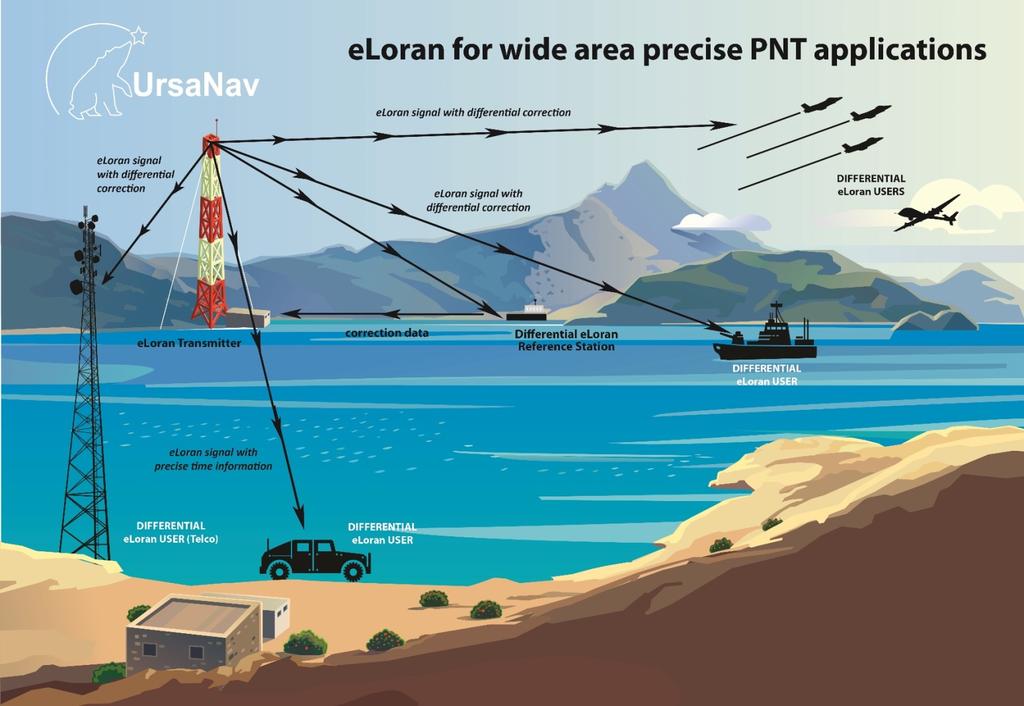
11 eloran Timing Evaluation Technology Laydown Wildwood, NJ to: (miles) USNO, DC: 120 Leesburg, VA: 140 N. Billerica, MA: 310 Rochester, NY 325 Gastonia, NC 425 Columbus, OH: 440 Bangor, ME: 500 Ocala, FL 790 LSU eloran transmitter at Wildwood, NJ Synchronized to UTC via Two Way Satellite Time Transfer (TWSTT) provided by US Naval Observatory 360KW of Effective Radiated Power Broadcasting dual rated as 8970 Master and Secondary LDC broadcast only on 8970 Secondary at raw data rate of 56 bps; effective rate of 21 bps Differential eloran Reference sites at: North Billerica, MA Leesburg, VA Gastonia, NC (Temporary)
12 Wildwood, NJ to Washington, DC (USNO) Washington, DC 2014 FRP +/- one microsecond as Y-Axis Period: December 2015 Distance to XMTR: 120 miles Mean: 22.9 ns STD: 26.1 ns Max: ns Min: ns
13 Wildwood, NJ to Washington, DC (USNO) Washington, DC 2014 FRP +/- one microsecond as Y-Axis Period: April 2016 Distance to XMTR: 120 miles Mean: 41.3 ns STD: 39.4 ns Max: ns Min: ns
14 Wildwood, NJ to Leesburg, VA Leesburg, VA 2014 FRP +/- one microsecond as Y-Axis Period: January 2016 Distance to XMTR: 140 miles Mean: ns STD: 79.9 ns Max: ns Min: ns
15 Wildwood, NJ to Leesburg, VA Leesburg, VA 2014 FRP +/- one microsecond as Y-Axis Period: April 2016 Distance to XMTR: 140 miles Mean: ns STD: 49.1 ns Max: ns Min: ns
16 Wildwood, NJ to Leesburg, VA Leesburg, VA 2014 FRP +/- one microsecond as Y-Axis Period: October November 2016 Distance to XMTR: 140 miles Mean: 79.1 Std : 33.1 Max : Min : -29.0
17 Wildwood, NJ to North Billerica, MA With and Without Differential Corrections ---North Billerica, MA --- With Differential Corrections 2014 FRP +/- one microsecond as Y-Axis Period: October November 2016 Distance to XMTR: 310 miles Without Differential corrections Mean: Std : 54.6 Max : Min : Period: October November 2016 Distance to XMTR: 310 miles With Differential corrections Mean: Std : 8.1 Max : 38.0 Min : -95.0
18 Wildwood, NJ to North Billerica, MA With and Without Differential Corrections ---North Billerica, MA --- With Differential Corrections 2014 FRP +/- one microsecond as Y-Axis Period: December 2016 Distance to XMTR: 310 miles Without Differential corrections Mean: Std : 92.8 Max : Min : 12.0 Period: December 2016 Distance to XMTR: 310 miles With Differential corrections Mean: -5.1 Std : 9.7 Max : 32.0 Min : -40.0
19 Wildwood, NJ to Columbus, OH Columbus, OH 2014 FRP +/- one microsecond as Y-Axis Period: April 2016 Distance to XMTR: 440 miles Mean: ns STD: 56.4 ns Max: ns Min: ns
20 Wildwood, NJ to Columbus, OH Columbus, OH 2014 FRP +/- one microsecond as Y-Axis Period: November 2016 Distance to XMTR: 440 miles Mean: 93.8 Std : 74.1 Max : Min :
21 Wildwood, NJ to Bangor, ME Bangor, ME 2014 FRP +/- one microsecond as Y-Axis Period: December 2015 Distance to XMTR: 500 miles Mean: 49.7 ns STD: 68.6 ns Max: ns Min: ns
22 Wildwood, NJ to Bangor, ME Bangor, ME 2014 FRP +/- one microsecond as Y-Axis Period: April 2016 Distance to XMTR: 500 miles Mean: ns STD: 69.7 ns Max: ns Min: ns
23 Wildwood, NJ to Bangor, ME Bangor, ME 2014 FRP +/- one microsecond as Y-Axis Period: August 2016 Distance to XMTR: 500 miles Mean: 87.6 Std : 32.9 Max : Min : 2.0
24 Wildwood, NJ to Bangor, ME Bangor, ME 2014 FRP +/- one microsecond as Y-Axis Period: December 2016 Distance to XMTR: 500 miles Mean: -9.1 Std : Max : Min :
25 Wildwood, NJ to Ocala, FL User Receiver Ocala, FL 2014 FRP +/- one microsecond as Y-Axis Period: December 2016 Distance to XMTR: 790 miles Mean: 93.0 Std : Max : Min :
26 eloran CRADA Summary Without differential corrections or augmentations, eloran results have easily demonstrated the ability to meet the (+/-) one microsecond timing synchronization requirement proposed in the 2014 Federal Radionavigation Plan (FRP) Without differential corrections or augmentations, eloran results within a 500 mile range of the test transmitter location have demonstrated (+/-) 500 nanoseconds synchronization to UTC Without differential corrections or augmentations, 95% of all data collected was within 200 Nanoseconds of UTC With differential corrections at certain locations in the vicinity of a Differential eloran Reference Station, eloran demonstrated time synchronization to UTC well within 100 nanoseconds eloran was proven in field trials to be a successful backup to GPS timing in a Wide Area Multilateration (WAM) aviation application, providing equivalent performance to GPS Additional aviation testing is ongoing, with plans underway to demonstrate precise time synchronization, Loran Data Channel (LDC) communication, and compass (heading) applications in Unmanned Aerial Vehicles and General Aviation aircraft in 2017 eloran in Smart Grid application Proofs-of-Concept are planned for later in 2017
27 Agenda eloran in Brief Overview Differences between Loran-C and eloran Capabilities eloran CRADA Results Description Detailed Results What Does it mean? eloran Timing coverage in the US Potential <1 µs Coverage Potential <100ns Coverage

28 Potential 1 µs Coverage 4 Station
29 Potential 1 µs Coverage 8 Station

30 Representative 100 ns Coverage Notional Location of Differential eloran Reference Station Site
31 UrsaNav Contact Us for Collaborative Efforts! UrsaNav, Inc. 85 Rangeway Road Building 3, Suite 110 North Billerica, MA
Providing a Resilient Timing and UTC Service Using eloran in the United States. Charles Schue - ION PTTI Monterey, CA
 Providing a Resilient Timing and UTC Service Using eloran in the United States Charles Schue - ION PTTI Monterey, CA January 27, 2016 Motivation For a Resilient Timing and UTC Service GPS/GNSS Vulnerabilities
Note that MIFD II will also be influencing standards in the US.
 1 2 Why should the Financial Sector care? Note that MIFD II will also be influencing standards in the US. The best contingency solutions is one that includes a Resilience Triad : GPS/GNSS, eloran, and
Implementing a Wide Area High Accuracy UTC Service via eloran
 Implementing a Wide Area High Accuracy UTC Service via eloran ION PTTI, Boston, MA December 3, 2014 Dr. Gerard Offermans Overview Basis for consideration of eloran as a source of precise time, frequency,
Providing a Resilient Timing and UTC Service Using eloran in the United States
 Providing a Resilient Timing and UTC Service Using eloran in the United States Gerard Offermans, Steve Bartlett, Charles Schue, UrsaNav, Inc. BIOGRAPHIES Dr. Gerard Offermans is Senior Research Scientist
U.S. Perspectives on eloran as a Timing Backup And Available Hardware. Charles Schue UrsaNav, Inc. KTN Trinity House October 8, 2012
 U.S. Perspectives on eloran as a Timing Backup And Available Hardware Charles Schue UrsaNav, Inc. KTN Trinity House October 8, 2012 Corporate Overview Chesapeake, Virginia, USA Founded in 2004 Four main
Leadership in Resilient PNT
 www.ursanav.com www.nautelnav.com 29 November 2017 Leadership in Resilient PNT The Need for Resilient PNT Position, Navigation, and Timing, or PNT, is known as the hidden utility. Despite its widespread
Modernized LORAN-C Timing Test Bed Status and Results
 Modernized LORAN-C Timing Test Bed Status and Results Tom Celano and Casey Biggs Timing Solutions Corporation 4775 Walnut St Boulder, CO tpcelano@timing.com Benjamin Peterson Peterson Integrated Positioning
Canadian Coast Guard Review to Implement a Resilient Position, Navigation and Timing Solution for Canada. Mariners Workshop January 31 st, 2018
 Canadian Coast Guard Review to Implement a Resilient Position, Navigation and Timing Solution for Canada Mariners Workshop January 31 st, 2018 Outline Overview of GNSS use in the marine sector CCG Activities
Resilience through co-primary PNT solutions: GPS and eloran. By Charles Schue September 4, 2014
 1 Resilience through co-primary PNT solutions: GPS and eloran By Charles Schue September 4, 2014 Outline The Problem: Vulnerabilities The Need: Resilience The Solution: Co-Primary GPS and eloran eloran
Modernized LORAN-C Timing Test Bed Status and Results
 Modernized LORAN-C Timing Test Bed Status and Results Tom Celano and Casey Biggs Timing Solutions Corporation 4775 Walnut St Boulder, CO tpcelano@timing.com Benjamin Peterson Peterson Integrated Positioning
A Holistic Approach to Trusted, Resilient PNT: GNSS, STL and eloran
 A Holistic Approach to Trusted, Resilient PNT: GNSS, STL and eloran John Fischer, Vice President of Research & Development, Orolia Dr. Michael O Connor, CEO, Satelles Charles Schue, CEO, UrsaNav With an
On the Uses of High Accuracy eloran Time, Frequency, and Phase
 On the Uses of High Accuracy eloran Time, Frequency, and Phase RIN INC, Manchester, England February 25, 2015 Charles Schue President & CEO UrsaNav, Inc. Overview The Problem: We need time all the time!
Navigati. GNSS Resilience. The Magazine of the Royal Institute of Navigation MAY/JUN Resilience Has A Name Its name is eloran
 Navigati MAY/JUN 2014 5.00 The Magazine of the Royal Institute of Navigation GNSS Resilience The Navigation of Navigation How we got to where we are with GNSS Resilience Has A Name Its name is eloran The
Protection Augmentation Toughness and Alternatives of GNSS. Melaha 2016 Concord Al-Salam Hotel Cairo, April 25,2016 Refaat Rashad
 Protection Augmentation Toughness and Alternatives of GNSS Melaha 2016 Concord Al-Salam Hotel Cairo, April 25,2016 Refaat Rashad Road Map of the Presentation 1- How Good are GNSS 2- How Vulnerable are
Synchrophasors Using eloran Timing Source
 Synchrphasrs Using elran Timing Surce Erik Jhannessen 1, Andrei Grebnev 1, Stephen Bartlett 1, Lingwei Zhan 2, Jiecheng Zha 3, Yilu Liu 2, 3 (1. UrsaNav Inc., 2. Oak Ridge Natinal Labratry, 3. the University
eloran Points of Light
 There is considerable misinformation, outdated information, and obviously misleading information being promulgated as fact about Enhanced Loran (eloran). This Points of Light paper is intended to respond
eloran Points of Light
 There is considerable misinformation, outdated information, and obviously misleading information being promulgated as fact about Enhanced Loran (eloran). This Points of Light paper is intended to respond
Design and Performance of a Low Frequency Time and Frequency Dissemination Service
 Design and Performance of a Low Frequency Time and Frequency Dissemination Service Dr. Arthur Helwig, Dr. Gerard Offermans, Chris Stout, Charles Schue, UrsaNav, Inc. BIOGRAPHIES Dr. Arthur Helwig is a
Transmission and User Requirements Technology for eloran (eloran 의송신기술및수신기기술 ) - Public Version -
 - Public Version -") Shared interest in a more productive tomorrow. Transmission and User Requirements Technology for eloran (eloran 의송신기술및수신기기술 ) - Public Version - Presented by: Mr. Charles Schue, President & CEO Mr. John
Shared interest in a more productive tomorrow. Transmission and User Requirements Technology for eloran (eloran 의송신기술및수신기기술 ) - Public Version - Presented by: Mr. Charles Schue, President & CEO Mr. John
Enhanced Loran. Sherman Lo, Benjamin Peterson With contributions from the FAA Loran Evaluation Team
 Enhanced Loran Sherman Lo, Benjamin Peterson With contributions from the FAA Loran Evaluation Team Acknowledgments & Disclaimer The presenters gratefully acknowledge the Federal Aviation Administration
Timing via the New LORAN-C System W H I T E PA P E R
 Timing via the New LORAN-C System WHITE PAPER Timing via the New LORAN-C System LT Kevin Carroll, USCG Loran Support Unit Tom Celano, Symmetricom Abstract In 1999, the United States Federal Radionavigation
PTTI CAPABILITIES OF THE MODERNIZED LORAN SYSTEM
 PTTI CAPABILITIES OF THE MODERNIZED LORAN SYSTEM Kirk Montgomery Symmetricom, Inc. kmontgomery@symmetricom.com Michael A. Lombardi Time and Frequency Division National Institute of Standards and Technology
eloran The eloran Evaluation and Modernization Program --- Acknowledging the Past Looking to the Future Federal Aviation Administration
 The eloran Evaluation and Modernization Program --- Acknowledging the Past Looking to the Future eloran Mitchell J. Narins Program Manager Navigation Services International Loran Association Conference
The Politics of Resilience Speaking Truth to Power the Last 18 Months
 The Politics of Resilience Speaking Truth to Power the Last 18 Months APRIL 2017 Workshop On Synchronization & Timing a single point of failure December 2015 US increasingly at risk from disruption 2011
Integrated Navigation System Eurofix Vision, Concept, Design, Implementation & Test
 Navtech Part # 1142 Integrated Navigation System Eurofix Vision, Concept, Design, Implementation & Test Gerard Offermans, Arthur Helwig Table of Contents Introduction...1 1.1 Navigation impact on society...
The Loran-C Resource in China and Its Potential Applications
 The Loran-C Resource in China and Its Potential Applications WU Haitao BIAN Yujing LI Zhigang Shaanxi Astronomical Observatory, The Chinese Academy of Sciences, P.O.Box 18,Lintong Shaanxi, China, 710600
Differential and Rubidium-Disciplined Test Results from an Iridium-Based Secure Timing Solution
 Differential and Rubidium-Disciplined Test Results from an Iridium-Based Secure Timing Solution Dr. Stewart Cobb Satelles, Inc. WSTS-2017 The Need for GNSS Augmentation The world has come to rely on GNSS
Communications Sector. Use of Positioning, Navigation and Timing (PNT) Services
 Services") Communications Sector Use of Positioning, Navigation and Timing (PNT) Services These comments are based upon public and private assertions made by representatives of this Critical Infrastructure/Key Resource
Communications Sector Use of Positioning, Navigation and Timing (PNT) Services These comments are based upon public and private assertions made by representatives of this Critical Infrastructure/Key Resource
PROGRAM MANAGER S NOTE
 Loran s Capability to Mitigate the Impact of a GPS Outage on GPS Position, Navigation, and Time Applications Prepared for the FEDERAL AVIATION ADMINISTRATION VICE PRESIDENT FOR TECHNICAL OPERATIONS NAVIGATION
Results from a GPS Timing Criticality Assessment
 Results from a GPS Timing Criticality Assessment European Navigation Conference, GNSS 2008 Session 2b - Timing James Carroll, DOT/RITA Volpe Center April 2008 Introduction Timing Criticality Assessment
S a t e l l i t e T i m e a n d L o c a t i o n. N o v e m b e r John Fischer VP Advanced R&D
 STL - S a t e l l i t e T i m e a n d L o c a t i o n N o v e m b e r 2 0 1 7 John Fischer VP Advanced R&D jfischer@orolia.com 11/28/201 1 7 WHY AUGMENT GNSS? Recent UK Study Economic Input to UK of a
Black Swans, White Elephants and Delivering a New National Timescale with eloran
 Black Swans, White Elephants and Delivering a New National Timescale with eloran Charles Curry BEng, CEng, FIET Managing Director Chronos Technology Ltd SFR, Paris 18 th July 2014 PNT First Experiences
Defining Primary, Secondary, Additional Secondary Factors for RTCM Minimum Performance Specifications (MPS)
") Defining Primary, Secondary, Additional Secondary Factors for RTCM Minimum Performance Specifications (MPS) Sherman Lo, Stanford University, Michael Leathem, Cross Rate Technologies, Gerard Offermans,
Defining Primary, Secondary, Additional Secondary Factors for RTCM Minimum Performance Specifications (MPS) Sherman Lo, Stanford University, Michael Leathem, Cross Rate Technologies, Gerard Offermans,
Wide-Area Time Distribution with PTP Using Commercial Telecom Optical Fiber
 Wide-Area Time Distribution with Using Commercial Telecom Optical Fiber NASPI Work Group Meeting March 22, 2017 Lee Cosart, lee.cosart@microsemi.com Microsemi Corporation Presenter, Co-author Marc Weiss,
Energy Sector. Use of Positioning, Navigation and Timing (PNT) Services
 Services") Energy Sector Use of Positioning, Navigation and Timing (PNT) Services These comments are based upon public and private assertions made by representatives of this Critical Infrastructure/Key Resource sector
Energy Sector Use of Positioning, Navigation and Timing (PNT) Services These comments are based upon public and private assertions made by representatives of this Critical Infrastructure/Key Resource sector
Civil GPS Service Interface Committee (CGSIC) International Committee on GNSS November 2016
 International Committee on GNSS November 2016") Civil GPS Service Interface Committee (CGSIC) International Committee on GNSS 06-11 November 2016 Russell Holmes CGSIC Deputy Chair U.S. Coast Guard Navigation Center 30 th Anniversary of the CGSIC CGSIC
Civil GPS Service Interface Committee (CGSIC) International Committee on GNSS 06-11 November 2016 Russell Holmes CGSIC Deputy Chair U.S. Coast Guard Navigation Center 30 th Anniversary of the CGSIC CGSIC
GPS Interference Detection & Mitigation
 GPS Interference Detection & Mitigation GAARDIAN GNSS AVAILABILITY ACCURACY RELIABILITY and INTEGRITY ASSESSMENT for TIMING and NAVIGATION A Technology Strategy Board funded collaboration Charles Curry,
Low Frequency (LF) Solutions for Alternative Positioning, Navigation, Timing, and Data (APNT&D) and Associated Receiver Technology
 Solutions for Alternative Positioning, Navigation, Timing, and Data (APNT&D) and Associated Receiver Technology") Low Frequency (LF) Solutions for Alternative Positioning, Navigation, Timing, and Data (APNT&D) and Associated Receiver Technology Arthur Helwig, Gerard Offermans, Charles Schue, UrsaNav, Inc. Brian Walker,
Low Frequency (LF) Solutions for Alternative Positioning, Navigation, Timing, and Data (APNT&D) and Associated Receiver Technology Arthur Helwig, Gerard Offermans, Charles Schue, UrsaNav, Inc. Brian Walker,
CHAPTER 24 LORAN NAVIGATION
 CHAPTER 24 LORAN NAVIGATION INTRODUCTION TO LORAN 2400. History and Role of Loran The theory behind the operation of hyperbolic navigation systems was known in the late 1930s, but it took the urgency of
LC DELTA: Low Cost Digitally Enhanced Loran for Tactical Applications
 1 LC DELTA: Low Cost Digitally Enhanced Loran for Tactical Applications Tom Celano Dr. Ben Peterson Chuck Schue 2 outline introduction / soapbox what is lc delta, aka tactical loran? requirements for tactical
Three Wishes. and an elaboration. For Reception of. Professor Bradford Parkinson Stanford University. (these are my personal views)
") Three Wishes and an elaboration For Reception of Professor Bradford Parkinson Stanford University (these are my personal views) Three Wishes - Dr, Parkinson 2017 1 Good News: World-wide dependency on GNSS
Three Wishes and an elaboration For Reception of Professor Bradford Parkinson Stanford University (these are my personal views) Three Wishes - Dr, Parkinson 2017 1 Good News: World-wide dependency on GNSS
A Review of Vulnerabilities of ADS-B
 A Review of Vulnerabilities of ADS-B S. Sudha Rani 1, R. Hemalatha 2 Post Graduate Student, Dept. of ECE, Osmania University, 1 Asst. Professor, Dept. of ECE, Osmania University 2 Email: ssrani.me.ou@gmail.com
Alternative Positioning, Navigation, Timing, and Data for Korea and the World
 Shared interest in a more productive tomorrow. Alternative Positioning, Navigation, Timing, and Data for Korea and the World Prepared by: Mr. Charles Schue, President & CEO ILA40 / KIN November 17, 2011
GPS & other Radio Time sources
 GPS & other Radio Time sources Anthony Flavin, MIET Chronos Technology Ltd Wireless Heritage SIG Time for Telecoms British Science Museum Friday 16th April 2018 Chronos Technology: COMPANY PROPRIETARY
Update from the United States Space-Based Positioning, Navigation, and Timing Advisory Board
 Update from the United States Space-Based Positioning, Navigation, and Timing Advisory Board John W. Betz, PhD PNTAB Member Presented to ICG-12, Kyoto, Japan December 2017 Approved for Public Release;
CAN LORAN MEET GPS BACKUP REQUIREMENTS?
 To be presented at the 11 th Saint Petersburg International Conference on Integrated Navigation Systems, 24 26 May 24 CAN LORAN MEET GPS BACKUP REQUIREMENTS? Gregory Johnson, MSEE, Ruslan Shalaev, BSCS
Recommendations on Differential GNSS
 Recommendations on Differential GNSS Mr. Joseph W. Spalding USCG Research & Development Center Dr. Jacques Beser S Navigation Inc. Dr. Frank van Diggelen Ashtech, Inc. BIOGRAPHY Mr. Joseph Spalding is
Maritime Electronics Supporting Unmanned Vessels
 EU-Japan Policy Workshop Maritime Electronics Supporting Unmanned Vessels November 11 th, 2016 TAKUO KASHIWA, Ph.D Furuno Electric Co., Ltd. Agenda Positioning Technologies for Vessel s position Technologies
COMMON-VIEW LORAN-C AS A BACKUP TO GPS FOR PRECISE TIME RECOVERY
 COMMON-VIEW LORAN-C AS A BACKUP TO GPS FOR PRECISE TIME RECOVERY Tom Celano, Timing Solutions Corporation LT Kevin Carroll, USCG Loran Support Unit Casey Biggs, Timing Solutions Corporation and Michael
Improving Loran Coverage with Low Power Transmitters
 Improving Loran Coverage with Low Power Transmitters Benjamin B. Peterson, Peterson Integrated Geopositioning Sherman C. Lo, Stanford University Tim Hardy, Nautel Per K. Enge, Stanford University BIOGRAPHY
Understanding GPS: Principles and Applications Second Edition
 Understanding GPS: Principles and Applications Second Edition Elliott Kaplan and Christopher Hegarty ISBN 1-58053-894-0 Approx. 680 pages Navtech Part #1024 This thoroughly updated second edition of an
GNSS VULNERABILITY AND CRITICAL INFRASTRUCTURE
 GNSS VULNERABILITY AND CRITICAL INFRASTRUCTURE NNF CONFERENCE 24 MAY 2012 Brynjar Hansen Senior adviser Norwegian Space Centre Lars Giske Senior adviser Norwegian Space Centre MULTI GNSS EXTERNAL COOPERATION
DARPA developing Very Low Frequency (VLF) systems to provide GPS like position and timing technologies
 systems to provide GPS like position and timing technologies") DARPA developing Very Low Frequency (VLF) systems to provide GPS like position and timing technologies in contested, underwater and underground Environments The GPS system provides critical positioning
DARPA developing Very Low Frequency (VLF) systems to provide GPS like position and timing technologies in contested, underwater and underground Environments The GPS system provides critical positioning
The Effect of Radio Frequency Interference on GNSS Signals and Mitigation Techniques Presented by Dr. Tarek Attia
 International Conference and Exhibition Melaha2016 GNSS WAY Ahead 25-27 April2016, Cairo, Egypt The Effect of Radio Frequency Interference on GNSS Signals and Mitigation Techniques Presented by Dr. Tarek
eloran and Amateur Radio A Study in Coexistence
 1 eloran and Amateur Radio A Study in Coexistence Dr Paul Williams 1 Professor David Last 2 Dr Nick Ward 1 1 General Lighthouse Authorities of Great Britain and Ireland (GLAs) 2 Consultant to the GLAs
PRECISE TIME DISTRIBUTION THROUGH INMARSAT FOR USE IN POWER SYSTEM CONTROL. Alison Brown and Scott Morell, NAVSYS Corporation ABSTRACT INTRODUCTION
 PRECISE TIME DISTRIBUTION THROUGH INMARSAT FOR USE IN POWER SYSTEM CONTROL Alison Brown and Scott Morell, NAVSYS Corporation ABSTRACT Inmarsat has designed a GPS (L1) transponder that will be included
The Benefit of Alternative Position, Navigation, and Timing (APNT) to Aviation and Other User Communities for Precise Time and Frequency Services
 to Aviation and Other User Communities for Precise Time and Frequency Services") The Benefit of Alternative Position, Navigation, and Timing (APNT) to Aviation and Other User Communities for Precise Time and Frequency Services Mitch Narins, US Federal Aviation Administration Sherman
The Benefit of Alternative Position, Navigation, and Timing (APNT) to Aviation and Other User Communities for Precise Time and Frequency Services Mitch Narins, US Federal Aviation Administration Sherman
Transportation Systems Sector. Use of Positioning, Navigation and Timing (PNT) Services
 Services") Transportation Systems Sector Use of Positioning, Navigation and Timing (PNT) Services These comments are based upon public and private assertions made by representatives of this Critical Infrastructure/Key
Transportation Systems Sector Use of Positioning, Navigation and Timing (PNT) Services These comments are based upon public and private assertions made by representatives of this Critical Infrastructure/Key
Differential Loran-C
 Differential Loran-C Kevin M. Carroll and Anthony Hawes, U. S. Coast Guard Loran Support Unit Benjamin Peterson and Kenneth Dykstra, Peterson Integrated Geopositioning, LLC Peter Swaszek, University of
Information Technology Sector. Use of Positioning, Navigation and Timing (PNT) Services
 Services") Information Technology Sector Use of Positioning, Navigation and Timing (PNT) Services These comments are based upon public and private assertions made by representatives of this Critical Infrastructure/Key
Information Technology Sector Use of Positioning, Navigation and Timing (PNT) Services These comments are based upon public and private assertions made by representatives of this Critical Infrastructure/Key
WRC19 Preparatory Workshop
 ICAO Doc 9718 Handbook on Radio Frequency Spectrum Requirements for Civil Aviation Vol. I - ICAO Spectrum Strategy Vol. II - Frequency Planning 100 khz 200 khz 300 khz 400 khz 600 khz 800 khz 1 MHz 2 MHz
Geoscience & Positioning, Navigation and Timing Services for Canadians
 Geoscience & Positioning, Navigation and Timing Services for Canadians Calvin Klatt, Ph.D. Director and Chief Geodesist Natural Resources Canada / Directeur et géodésien principal Ressources naturelles
ICAO Handbook on Radio Frequency Spectrum Requirements for Civil Aviation Vol. I - ICAO Spectrum Strategy Vol. II - Frequency Planning
 ICAO Handbook on Radio Frequency Spectrum Requirements for Civil Aviation Vol. I - ICAO Spectrum Strategy Vol. II - Frequency Planning 100 khz 200 khz 300 khz 400 khz 600 khz 800 khz 1 MHz 2 MHz 3 MHz
RECOMMENDATION ITU-R M.1830
 Rec. ITU-R M.1830 1 RECOMMENDATION ITU-R M.1830 Technical characteristics and protection criteria of aeronautical radionavigation service systems in the 645-862 MHz frequency band (2007) Scope This Recommendation
TACSAT-2 Target Indicator Experiment (TIE) AIS Payload Overview
 AIS Payload Overview") TACSAT-2 Target Indicator Experiment (TIE) AIS Payload Overview 2007 Maritime Domain Awareness Forum 29 October 2007 NRL_2007-MDAF-29OCT-TIE.1 Christopher Huffine Technical Staff, Code 8120 Naval Research
TACSAT-2 Target Indicator Experiment (TIE) AIS Payload Overview 2007 Maritime Domain Awareness Forum 29 October 2007 NRL_2007-MDAF-29OCT-TIE.1 Christopher Huffine Technical Staff, Code 8120 Naval Research
POLISH MARITIME DGPS REFERENCE STATIONS COVERAGE AFTER THE IMPLEMENTATION OF NEW FREQUENCY NET PRELIMINARY RESULTS.
 POLISH MARITIME DGPS REFERENCE STATIONS COVERAGE AFTER THE IMPLEMENTATION OF NEW FREQUENCY NET PRELIMINARY RESULTS. Cezary Specht Institute of Navigation and Hydrography of Naval University in Gdynia ABSTRACT
On Location at Stanford University
 Thank you for inviting me to Calgary On Location at Stanford University by Per Enge (with the help of many) May 29, 2009 With Gratitude to the Federal Aviation Administration from Misra and Enge, 2006
TIME AND FREQUENCY ACTIVITIES AT THE CSIR NATIONAL METROLOGY LABORATORY
 TIME AND FREQUENCY ACTIVITIES AT THE CSIR NATIONAL METROLOGY LABORATORY E. L. Marais and B. Theron CSIR National Metrology Laboratory PO Box 395, Pretoria, 0001, South Africa Tel: +27 12 841 3013; Fax:
Mobile Security Fall 2015
 Mobile Security Fall 2015 Patrick Tague #8: Location Services 1 Class #8 Location services for mobile phones Cellular localization WiFi localization GPS / GNSS 2 Mobile Location Mobile location has become
edloran next generation of differential Loran
 edloran next generation of differential Loran Durk van Willigen 1, René Kellenbach 2, Cees Dekker 3 and Wim van Buuren 4 1 Reelektronika, Netherlands, d.vanwilligen@reelektronika.nl 2 Reelektronika, Netherlands,
The GLOBAL POSITIONING SYSTEM James R. Clynch February 2006
 The GLOBAL POSITIONING SYSTEM James R. Clynch February 2006 I. Introduction What is GPS The Global Positioning System, or GPS, is a satellite based navigation system developed by the United States Defense
Aircraft Communication and Navigation Systems
 Unit 86: Aircraft Communication and Navigation Systems Unit code: J/601/7217 QCF level: 4 Credit value: 15 Aim The aim of this unit is to develop learners understanding of the principles of operating aircraft
CHAPTER 6 LONG RANGE NAVIGATIONAL AIDS PART I LORAN-C
 CHAPTER 6 LONG RANGE NAVIGATIONAL AIDS PART I LORAN-C 600A. Acronyms.............................................................................. 6-3 600B. Definitions.............................................................................
Automatic Dependent Surveillance -ADS-B
 ASECNA Workshop on ADS-B (Dakar, Senegal, 22 to 23 July 2014) Automatic Dependent Surveillance -ADS-B Presented by FX SALAMBANGA Regional Officer, CNS WACAF OUTLINE I Definition II Principles III Architecture
Surviving and Operating Through GPS Denial and Deception Attack. Nathan Shults Kiewit Engineering Group Aaron Fansler AMPEX Intelligent Systems
 Surviving and Operating Through GPS Denial and Deception Attack Nathan Shults Kiewit Engineering Group Aaron Fansler AMPEX Intelligent Systems How GPS Works GPS Satellite sends exact time (~3 nanoseconds)
Experiences in. Flight Inspecting GBAS
 Experiences in Flight Inspecting GBAS Thorsten Heinke Aerodata AG 1 Flight Inspection of GBAS Overview Basics Requirements Equipment Flight Inspection 2 Ground Based Augmentation System VDB Tx-Frequency
Three Wishes - Dr, Parkinson
 Three Wishes - Dr, Parkinson 2017 1 Three Wishes and an elaboration For Reception of Professor Bradford Parkinson Stanford University (these are my personal views) Three Wishes - Dr, Parkinson 2017 2 Good
AE4-393: Avionics Exam Solutions
 AE4-393: Avionics Exam Solutions 2008-01-30 1. AVIONICS GENERAL a) WAAS: Wide Area Augmentation System: an air navigation aid developed by the Federal Aviation Administration to augment the Global Positioning
HD Radio FM Transmission System Specifications
 HD Radio FM Transmission System Specifications Rev. D February 18, 2005 Doc. No. SY_SSS_1026s TRADEMARKS The ibiquity Digital logo and ibiquity Digital are registered trademarks of ibiquity Digital Corporation.
Alternative Positioning, Navigation and Timing (APNT) for Performance Based Navigation (PBN)
 for Performance Based Navigation (PBN)") DLR.de Chart 1 Alternative Positioning, Navigation and Timing (APNT) for Performance Based Navigation (PBN) Presented by Boubeker Belabbas Prepared by : Nicolas Schneckenburger, Elisabeth Nossek, Dmitriy
DLR.de Chart 1 Alternative Positioning, Navigation and Timing (APNT) for Performance Based Navigation (PBN) Presented by Boubeker Belabbas Prepared by : Nicolas Schneckenburger, Elisabeth Nossek, Dmitriy
Caribbean Digital Broadcasting Switchover Forum th 15 th August Telecommunications Authority of Trinidad and Tobago
 Caribbean Digital Broadcasting Switchover Forum 2012 13 th 15 th August 2012 Telecommunications Authority of Trinidad and Tobago 1 Parameters in Network design Elements of the reception Design Considerations
Emergency Services Sector (Law Enforcement, EMS & Incident Management) Use of Positioning, Navigation and Timing (PNT) Services
 Use of Positioning, Navigation and Timing (PNT) Services") Emergency Services Sector (Law Enforcement, EMS & Incident Management) Use of Positioning, Navigation and Timing (PNT) Services These comments are based upon public and private assertions made by representatives
Emergency Services Sector (Law Enforcement, EMS & Incident Management) Use of Positioning, Navigation and Timing (PNT) Services These comments are based upon public and private assertions made by representatives
Antenna Engineering Lecture 0: Introduction
 Antenna Engineering Lecture 0: Introduction ELC 405a Fall 2011 Department of Electronics and Communications Engineering Faculty of Engineering Cairo University 2 Outline 1 Why Study Antenna Engineering?
RECOMMENDATION ITU-R M *
 Rec. ITU-R M.823-3 1 RECOMMENDATION ITU-R M.823-3 * Technical characteristics of differential transmissions for global navigation satellite systems from maritime radio beacons in the frequency band 283.5-315
HD Radio FM Transmission. System Specifications
 HD Radio FM Transmission System Specifications Rev. G December 14, 2016 SY_SSS_1026s TRADEMARKS HD Radio and the HD, HD Radio, and Arc logos are proprietary trademarks of ibiquity Digital Corporation.
GPS Evidence - Where s It Taking Us?
 GPS Evidence - Where s It Taking Us? Professor David Last International Communications Data & Digital Forensics Seminars 17-21 March 2014 Picture: earthobservatory.nasa. gov//ewsroom/bluemarble/ David
The U.S. government appears
 The U.S. government appears to be closing in on a decision about whether to revive plans for an enhanced Loran (eloran) system, as a backup for the position, navigation, and timing (PNT) information provided
02 Issue. e-navigation News. GNSS Vulnerability. Dublin Bay Digital Diamond. e-navigation. Demonstrator Update International. e-navigation.
 CORPORATE SECURITY TEAMWORK EVENTS 02 Issue e-navigation News GNSS Vulnerability Dublin Bay Digital Diamond e-navigation Demonstrator Update International e-navigation update June 2014 www.cil.ie +353
GPS Adjacent Band Compatibility Assessment
 GPS Adjacent Band Compatibility Assessment Space-Based PNT Advisory Board Meeting May 18, 2016 EXCOM Co-Chair Letter to NTIA... without affecting existing and evolving uses of space-based PNT services
International Spectrum Management and Interference Mitigation
 International Spectrum Management and Interference Mitigation 1 Related ITU documents Prevention of interference Resolving cases of interference Radiomonitoring as a complementary instrument of interference
On Location at Stanford University
 Thank you for inviting me (back) to Deutsches Zentrum für Luft- und Raumfahrt On Location at Stanford University by Per Enge (with the help of many) July 27, 2009 My thanks to the Federal Aviation Administration
Future Dual Systems for Landing. The DGNSS PALS opportunity Marco Donfrancesco Intelligence & Cyber EW Sales & Mktg
 Future Dual Systems for Landing. The DGNSS PALS opportunity Marco Donfrancesco Intelligence & Cyber EW Sales & Mktg SG-175 DGNSS PALS study The study shall provide technical advice on the data link capabilities
Public Workshop on Optimising the Use of the Radio Spectrum by the Public Sector in the EU. Applications and Technologies
 Public Workshop on Optimising the Use of the Radio Spectrum by the Public Sector in the EU Applications and Technologies John Burns, Aegis Systems Ltd 1st April 2008 0 Scope of Presentation Overview of
How to Place in the Results of the April 8th, 2015, Frequency Measuring Test
 How to Place in the Results of the April 8th, 2015, Frequency Measuring Test Prepared for the monthly meeting of the Harris Intersil Amateur Radio Club March 12, 2015 Dennis I. O Quinn, K4CXX III-12-15,r0.4
Footnotes to National Frequency Allocation of Japan (Column 4)
") Footnotes to National Frequency Allocation of Japan (Column 4) J1 In authorizing the use of frequencies below 8.3kHz, it shall be ensured that no harmful interference is thereby caused to the services
Footnotes to National Frequency Allocation of Japan (Column 4) J1 In authorizing the use of frequencies below 8.3kHz, it shall be ensured that no harmful interference is thereby caused to the services
Multi-sensor Navigation Systems: Concepts, Evolution, Trends and Applications
 Multi-sensor Navigation Systems: Concepts, Evolution, Trends and Applications Dorota A. Grejner-Brzezinska Lowber B. Strange Endowed Professor and Chair Department of Civil, Environmental and Geodetic
Alternative Positioning, Navigation & Timing (APNT) Study Update
 Study Update") Alternative Positioning, Navigation & Timing (APNT) Study Update Why APNT? The transformation of the National Airspace System (NAS) to the Next Generation Air Transportation System (NextGen) relies on
Alternative Positioning, Navigation & Timing (APNT) Study Update Why APNT? The transformation of the National Airspace System (NAS) to the Next Generation Air Transportation System (NextGen) relies on
Antenna Engineering Lecture 0: Introduction
 Antenna Engineering Lecture 0: Introduction ELCN405 Fall 2011 Communications and Computer Engineering Program Faculty of Engineering Cairo University 2 Outline 1 Electromagnetic Spectrum Recent Advances
LOCALIZATION WITH GPS UNAVAILABLE
 LOCALIZATION WITH GPS UNAVAILABLE ARES SWIEE MEETING - ROME, SEPT. 26 2014 TOR VERGATA UNIVERSITY Summary Introduction Technology State of art Application Scenarios vs. Technology Advanced Research in
Developing a GNSS resiliency framework for timing receivers. By Guy Buesnel and Adam Price Spirent Communications, October 2017
 Developing a GNSS resiliency framework for timing receivers By Guy Buesnel and Adam Price, October 2017 Overview of Spirent Positioning and Timing Mobile Devices Military Applications Commercial Air Travel