U.S. Perspectives on eloran as a Timing Backup And Available Hardware. Charles Schue UrsaNav, Inc. KTN Trinity House October 8, 2012
|
|
|
- Bertram Kenneth Hodge
- 5 years ago
- Views:
Transcription


1 U.S. Perspectives on eloran as a Timing Backup And Available Hardware Charles Schue UrsaNav, Inc. KTN Trinity House October 8, 2012


2 Corporate Overview Chesapeake, Virginia, USA Founded in 2004 Four main business units: C 5 ISR, IT, IM, LF World Leader in LF Technology Leesburg, Virginia, USA Principal locations in Virginia Regional offices in Massachusetts & South Carolina office handles EMEA opportunities Commercial and government clients in 32 countries. About us


 State-of-the-Art Transmitting & Receiver")


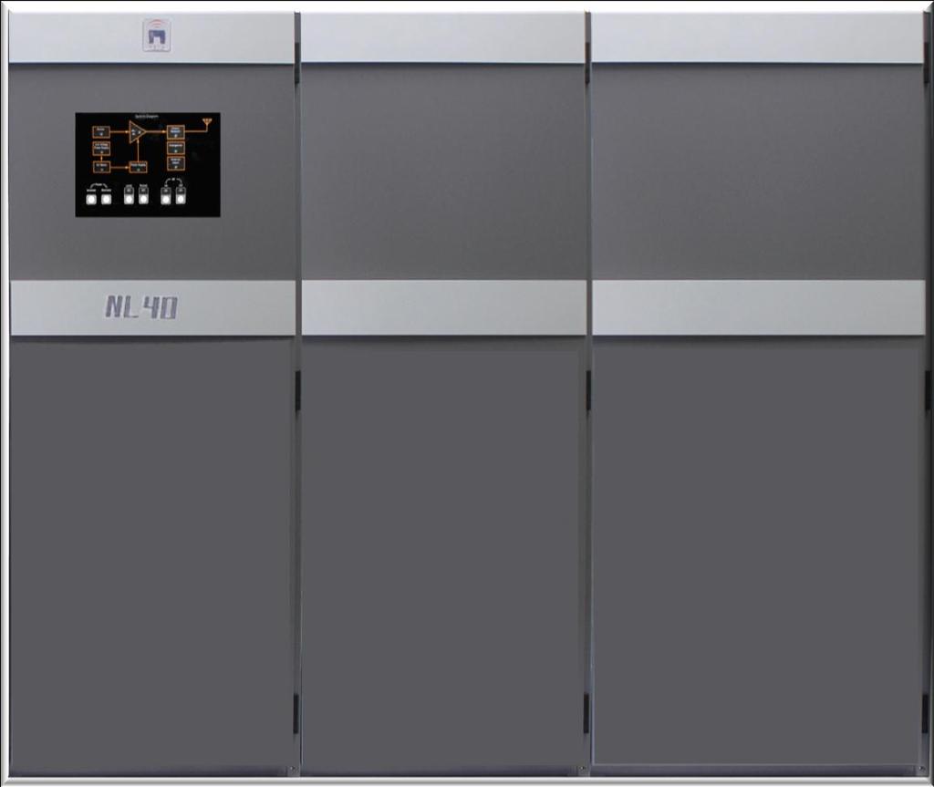
3 Low-Frequency Business Unit Alternative/Backup Solutions to GNSS/RNSS Loran-C, X Chayka, eloran, LFPhoenix, and Beyond Temporary, X Transportable, & Tactical Solutions 21 X st Century Technology Positioning, Navigation, Timing/Frequency & Data (PNTF&D) Systems X Symmetricom Time Scale Solutions X TWLFTT, TWLLTT, TWSTT X Transmit and Receive Antennae x Data Channel (9 th /10 th Pulse, Eurofix, Other) State-of-the-Art Transmitting & Receiver Technologies Nautel NL Series LF Transmitters X UrsaNav LF Multi-Mode Receivers X CrossRate, Locus, & Plutargus IP X Receivers for UK GAARDIAN/Sentinel IDM Differential GPS/GNSS Solutions Nautel Vector Series DGPS Transmitters X Trimble RS/IM Equipment X Trimble Control Station Software X Antennas, Nautel ATU, spares, shelters Installation, training


 of the sectors.")
4 GPS Dependent Systems e-navigation DGPS, ECDIS, DSC, AIS Radar, Synchronized Lights Homeland Security Defense Telecommunications Networks Landline / Mobile / Paging Systems Computer Networks / Internet Electrical Power Systems Phase Synchronization & Flow Control Banking & Finance High-Speed Trading ATM transactions Agriculture Of the (18) CIKR sectors, (15) use GPS timing. GPS timing is deemed essential for (11) of the sectors. [Source: Department of Homeland Security]

;")
5 U.S. Timing & Frequency Requirements Sources: Results from a GPS Timing Criticality Assessment, Carroll (DOT/VNTSC); Lombardi (NIST) 5
 Unintentional &")

 Common signal use across GNSS Radio frequency interference System anomalies & failures Jamming")
6 Why is an Alternative to GPS Timing Necessary? GNSS/RNSS Vulnerabilities Performance degradation Ionosphere & solar activities (natural) Unintentional & intentional (human factors) Signal blockage Spectrum competition (e.g., LSQ) Common signal use across GNSS Radio frequency interference System anomalies & failures Jamming Spoofing & Counterfeit Signals Low-cost personal privacy devices 100W Super Jammer (Range over ½ mile Plugs into cigarette lighter*) 150W L1 L5 Full Band Jammer (Range up to ¼ mile*) * Range as advertised on the supplier s website. Independent tests have shown significantly further ranges for lower output power.
7 Potential GPS Timing Loss: Sector Impact Industry Timing Requirement Impact of Loss Monetary Impact of Loss Banking / Financial 3 s absolute to 1ms Market vacuum (loss of liquidity); market "skimming"; leaked pricing information* Tens to Hundreds of Millions per Trade Telecommunications 1us Loss of communications, E911 Millions+ DoEnergy: Electrical Power SmartGrid 10 ms to 1us Grid stability, efficiency, outages, equipment damage Billions** DOD/DHS 1ms Loss of communications Safety / Security DOT: FAA <1us To 50ns Loss of ability to trilaterate position; loss of communications Safety, Security, Efficiency * Source: Dr. Todd Humphreys, University of Texas at Austin ** Source: 8/14/2003 NE Interconnection Outage
 sensors use timing or frequency for accurate")


8 Example: SmartGrid Timing Using GPS SmartGrid Phasor Measurement Unit (PMU) sensors use timing or frequency for accurate measurement of the power grid phase Sensors don t provide data without time synchronization 1/2 to 2/3 of PMUs currently unusable at any given time because of lost GPS timing Vulnerabilities include: Limited, to no, indoor GPS reception Low E windows are a problem for GPS


9 Why is eloran the Best Alternative? Time. Frequency. Data. Position. Terrestrial-based Significantly higher power than satellites Dissimilar failure modes to GPS Considerable usable range of > 1,000 miles Requires fewer transmitters than other terrestrial solutions Time, frequency, & data require only a single transmission site Independent of GPS, but interoperable with GPS Spectrum protected worldwide Lessons learned from LSQ ( GPS Band) Integrity built into eloran signal Also provides complementary integrity for GPS Available in many GPS denied environments Can meet, when appropriately equipped/designed: Maritime: HEA 8m-20m; IMO 10m Aviation RNP 0.3
10 Why is eloran the Best Alternative? Meets stringent timing reference requirements << 1 υs Transmissions synchronized to well within 10 ns of UTC Sub nanosecond synchronization with Two-Way Time Transfer Meets stringent frequency reference requirements Provides Stratum-1E standard better than 1 x long-term Same Stratum standard as GPS Meets or exceeds all public infrastructure needs AM, FM, TV, Electric Power, Telecomm, Mobile, Wireless, Banking, Finance, etc. Data Channel(s) available All manner of functionality, including time of day and corrections DGPS messages available (RTCM SC-104) Provides alternative wide-area critical messages/notifications Third-Party Data Channel options

11 U.S. Timing Providers Source: The Potential Role of eloran in the National Time and Frequency Infrastructure 11

12 U.S. Frequency Providers Source: The Potential Role of eloran in the National Time and Frequency Infrastructure 12
13 Why should we care? Robust, resilient, alternative PNT&F Truly multi-modal Seamless, interoperable, yet dissimilar to GNSS Extremely cost effective Sovereign control Traceable to UTC Can recover UTC from cold start w/o GPS Continuity of operations Even during jamming & spoofing events The M in Interference Detection & Mitigation Location Stamping - Proof of position * Time Stamping - Proof of time * * - Courtesy of Logan Scott Consulting.
 Two years after Loran-C Termination Promotes R&D efforts; tech transfer Not a contract; no exchange of funding; not government sponsored Objectives Research,")
14 September 2011 DHS report to Congress GPS timing important Concern for a lack of a backup(s) DHS investigating alternatives Precise time via wire/fiber Asked USCG to investigate wireless time transfer CRADA (Effective 02/13/2012) Two years after Loran-C Termination Promotes R&D efforts; tech transfer Not a contract; no exchange of funding; not government sponsored Objectives Research, evaluate, document Time. Frequency. Data. (Position.) LF in the USA: A Way Ahead Disclaimer: The USCG has no intent to acquire, operate, or provide wireless time technology or associated services.

15 Loran-C, eloran, LFPhoenix, and Beyond! Started testing February 29, 2012 Transmissions currently from dbf Wildwood, NJ Transmission to within <10 ns of UTC Able to transmit from any former Loran-C or GWEN site Able to transmit using transportable LF-in-a-Box solution Several test locations with multiple receivers (142 miles) Chambersburg, PA (160 miles) (170 miles) Burlington, MA (310 miles) Durham, NH (354 miles) Charleston, SC (505 miles) Mobile Measurement Unit TWSTT solution installed at dbf June, 2012 TWLFTT solution truly sky-free testing in 2013


16 TWSTT 1 PPS Router 5 MHz Router GNSS Time Scale 1 PPS Router 5 MHz Router LF Timing Generator online LF Receiver - UN151 LFDC Generator LFDC Integrity Monitor Local Station Controller GNSS Time Scale 1 PPS Router 5 MHz Router LF Timing Generator online LF Receiver - UN151 LFDC Generator LFDC Integrity Monitor Local Station Controller KVM/Display KVM/Display LAN UPS V LFDC LFDC UTC NAV Cesium 5071A Cesium 5071A Cesium 5071A UPS V LFDC LFDC LFDC UTC NAV LFDC Technology Exists Today Loran-C, eloran, LFPhoenix Global land-mass and EEZ+ coverage possible that is truly sky-free.
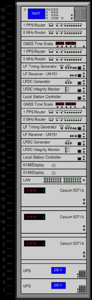


17 Transmitting Site Equipment Suite Rack 102 Wide x 39.5 Deep x 72.5 High

18 OEM Timing Receiver Module Engineered-to-Order: Higher SWAP-C Quantity Order: Significantly Lower SWAP-C Partial Sentinel Probe Interior Standard 19 Rack-Mount, 1u Enclosure eloran Receiver Dimensions: 4.75 x 6.75


19 First Blush Indoor Performance Test Prototype H-field antenna Dimensions: 38 x 38 x 19 mm 1.5 x 1.5 x.75 Smallest H-field antenna to date Antenna in noisy office environment 5 meters away from outside wall

20 Verified eloran T, F, & D Coverage Proper reception, tracking, & decoding of signals from dbf at Kansas City, MO 1,050 miles
21 Early Results: eloran Timing performance Time recovery to within 75 ns RMS (UTC) Distances to 500 miles (conservative; no differential corrections) External E-Field antenna Time recovery to within 200 ns RMS (UTC) At 1,000 miles (no differential corrections) External E-Field antenna One-time calibration against Symmetricom ATS-6501 Rb disciplined L1/L2 receiver; free-running afterwards Compensated for ASFs, receiver processing delays, cabling delays, etc. Calibration can be done using a hot-clock method, or with TWTT techniques Data Channel performance LF Data channel reception and decoding Distances exceeding 1,000 miles

22 Single Site eloran Scenario: 1,000 Mile Radius Wherever there is color, we expect LFDC demodulation. Acceptable modulation at 1,000 miles.

23 Multiple eloran Site Scenario: 1,000 Mile Radius T, F, & D Coverage Example for the Contiguous 48 States With Four Sites
24 AFCEA SIGNAL Magazine, October 2012 Global Positioning System Is a Single Point of Failure. GPS vulnerabilities could be addressed with upgraded long-range navigation. This is another example proving that the GPS system is vulnerable. The U.S. military must take a hard look at all solutions that would provide a redundant capability. One such possibility is a system known as long-range navigation (LORAN). This system was developed in 1958 to provide navigation for shipping. It uses powerful signal pulses at a low frequency and is not line-of-sight dependent. Consequently, LORAN does not have the same vulnerabilities as the GPS. However, on February 8, 2010, the U.S. Coast Guard stopped the LORAN transmissions, effectively retiring the system. Even though LORAN was retired, researchers at Stanford University and the U.S. Coast Guard continue to develop a 21st-century model. The project is known as eloran. It provides the added capability of a data channel plus vastly improved accuracy. For example, LORAN was accurate to approximately 460 meters, while eloran is accurate to between 8 and 20 meters. This is comparable to most handheld GPS receivers, which are accurate from 10 to 20 meters. The U.S. military has receivers that are accurate to less than one meter. eloran s accuracy will need to be developed further to provide the same military GPS capability. The United States needs to invest additional funding into this system to develop its viability as a backup to the GPS. However, the greatest argument against any new system is its cost.... Fiscal hawks will argue that the military does not require a redundant capability for the GPS. On the other hand, the U.S. National Security Strategy report states that the U.S. military must preserve its conventional superiority. Scientific innovation is exactly what is required to develop a redundant capability for the GPS. It is blatantly obvious that the GPS is highly vulnerable, and the United States must prioritize funding for research and development of a comparable system. eloran is one possible solution to this problem. The author, Captain Charles A. Barton III, USAF, is the chief of plans and programs at the 689th Combat Communications Wing, Robins Air Force Base, Georgia.

25 LF. Time. Frequency. Data. Today!
Providing a Resilient Timing and UTC Service Using eloran in the United States. Charles Schue - ION PTTI Monterey, CA
 Providing a Resilient Timing and UTC Service Using eloran in the United States Charles Schue - ION PTTI Monterey, CA January 27, 2016 Motivation For a Resilient Timing and UTC Service GPS/GNSS Vulnerabilities
Wide Area Time distribution Via eloran. NASPI WG Meeting
 Wide Area Time distribution Via eloran NASPI WG Meeting March 22 2017 This work is supported through a Cooperative Research and Development Agreement (CRADA) with the Department of Homeland Security (DHS)
Design and Performance of a Low Frequency Time and Frequency Dissemination Service
 Design and Performance of a Low Frequency Time and Frequency Dissemination Service Dr. Arthur Helwig, Dr. Gerard Offermans, Chris Stout, Charles Schue, UrsaNav, Inc. BIOGRAPHIES Dr. Arthur Helwig is a
Resilience through co-primary PNT solutions: GPS and eloran. By Charles Schue September 4, 2014
 1 Resilience through co-primary PNT solutions: GPS and eloran By Charles Schue September 4, 2014 Outline The Problem: Vulnerabilities The Need: Resilience The Solution: Co-Primary GPS and eloran eloran
Transmission and User Requirements Technology for eloran (eloran 의송신기술및수신기기술 ) - Public Version -
 - Public Version -") Shared interest in a more productive tomorrow. Transmission and User Requirements Technology for eloran (eloran 의송신기술및수신기기술 ) - Public Version - Presented by: Mr. Charles Schue, President & CEO Mr. John
Shared interest in a more productive tomorrow. Transmission and User Requirements Technology for eloran (eloran 의송신기술및수신기기술 ) - Public Version - Presented by: Mr. Charles Schue, President & CEO Mr. John
Note that MIFD II will also be influencing standards in the US.
 1 2 Why should the Financial Sector care? Note that MIFD II will also be influencing standards in the US. The best contingency solutions is one that includes a Resilience Triad : GPS/GNSS, eloran, and
Leadership in Resilient PNT
 www.ursanav.com www.nautelnav.com 29 November 2017 Leadership in Resilient PNT The Need for Resilient PNT Position, Navigation, and Timing, or PNT, is known as the hidden utility. Despite its widespread
On the Uses of High Accuracy eloran Time, Frequency, and Phase
 On the Uses of High Accuracy eloran Time, Frequency, and Phase RIN INC, Manchester, England February 25, 2015 Charles Schue President & CEO UrsaNav, Inc. Overview The Problem: We need time all the time!
Implementing a Wide Area High Accuracy UTC Service via eloran
 Implementing a Wide Area High Accuracy UTC Service via eloran ION PTTI, Boston, MA December 3, 2014 Dr. Gerard Offermans Overview Basis for consideration of eloran as a source of precise time, frequency,
Results from a GPS Timing Criticality Assessment
 Results from a GPS Timing Criticality Assessment European Navigation Conference, GNSS 2008 Session 2b - Timing James Carroll, DOT/RITA Volpe Center April 2008 Introduction Timing Criticality Assessment
Canadian Coast Guard Review to Implement a Resilient Position, Navigation and Timing Solution for Canada. Mariners Workshop January 31 st, 2018
 Canadian Coast Guard Review to Implement a Resilient Position, Navigation and Timing Solution for Canada Mariners Workshop January 31 st, 2018 Outline Overview of GNSS use in the marine sector CCG Activities
A Holistic Approach to Trusted, Resilient PNT: GNSS, STL and eloran
 A Holistic Approach to Trusted, Resilient PNT: GNSS, STL and eloran John Fischer, Vice President of Research & Development, Orolia Dr. Michael O Connor, CEO, Satelles Charles Schue, CEO, UrsaNav With an
Modernized LORAN-C Timing Test Bed Status and Results
 Modernized LORAN-C Timing Test Bed Status and Results Tom Celano and Casey Biggs Timing Solutions Corporation 4775 Walnut St Boulder, CO tpcelano@timing.com Benjamin Peterson Peterson Integrated Positioning
Providing a Resilient Timing and UTC Service Using eloran in the United States
 Providing a Resilient Timing and UTC Service Using eloran in the United States Gerard Offermans, Steve Bartlett, Charles Schue, UrsaNav, Inc. BIOGRAPHIES Dr. Gerard Offermans is Senior Research Scientist
Navigati. GNSS Resilience. The Magazine of the Royal Institute of Navigation MAY/JUN Resilience Has A Name Its name is eloran
 Navigati MAY/JUN 2014 5.00 The Magazine of the Royal Institute of Navigation GNSS Resilience The Navigation of Navigation How we got to where we are with GNSS Resilience Has A Name Its name is eloran The
Alternative Positioning, Navigation, Timing, and Data for Korea and the World
 Shared interest in a more productive tomorrow. Alternative Positioning, Navigation, Timing, and Data for Korea and the World Prepared by: Mr. Charles Schue, President & CEO ILA40 / KIN November 17, 2011
Timing via the New LORAN-C System W H I T E PA P E R
 Timing via the New LORAN-C System WHITE PAPER Timing via the New LORAN-C System LT Kevin Carroll, USCG Loran Support Unit Tom Celano, Symmetricom Abstract In 1999, the United States Federal Radionavigation
Energy Sector. Use of Positioning, Navigation and Timing (PNT) Services
 Services") Energy Sector Use of Positioning, Navigation and Timing (PNT) Services These comments are based upon public and private assertions made by representatives of this Critical Infrastructure/Key Resource sector
Energy Sector Use of Positioning, Navigation and Timing (PNT) Services These comments are based upon public and private assertions made by representatives of this Critical Infrastructure/Key Resource sector
GPS Jamming and its impact on maritime navigation
 GPS Jamming and its impact on maritime navigation Dr Alan Grant Research and Development - Special Interest Group 10 th May 2010 Use of GPS in the maritime sector GPS has become the normal means for maritime
Protection Augmentation Toughness and Alternatives of GNSS. Melaha 2016 Concord Al-Salam Hotel Cairo, April 25,2016 Refaat Rashad
 Protection Augmentation Toughness and Alternatives of GNSS Melaha 2016 Concord Al-Salam Hotel Cairo, April 25,2016 Refaat Rashad Road Map of the Presentation 1- How Good are GNSS 2- How Vulnerable are
Communications Sector. Use of Positioning, Navigation and Timing (PNT) Services
 Services") Communications Sector Use of Positioning, Navigation and Timing (PNT) Services These comments are based upon public and private assertions made by representatives of this Critical Infrastructure/Key Resource
Communications Sector Use of Positioning, Navigation and Timing (PNT) Services These comments are based upon public and private assertions made by representatives of this Critical Infrastructure/Key Resource
eloran Points of Light
 There is considerable misinformation, outdated information, and obviously misleading information being promulgated as fact about Enhanced Loran (eloran). This Points of Light paper is intended to respond
Black Swans, White Elephants and Delivering a New National Timescale with eloran
 Black Swans, White Elephants and Delivering a New National Timescale with eloran Charles Curry BEng, CEng, FIET Managing Director Chronos Technology Ltd SFR, Paris 18 th July 2014 PNT First Experiences
GPS & other Radio Time sources
 GPS & other Radio Time sources Anthony Flavin, MIET Chronos Technology Ltd Wireless Heritage SIG Time for Telecoms British Science Museum Friday 16th April 2018 Chronos Technology: COMPANY PROPRIETARY
eloran Points of Light
 There is considerable misinformation, outdated information, and obviously misleading information being promulgated as fact about Enhanced Loran (eloran). This Points of Light paper is intended to respond
The Politics of Resilience Speaking Truth to Power the Last 18 Months
 The Politics of Resilience Speaking Truth to Power the Last 18 Months APRIL 2017 Workshop On Synchronization & Timing a single point of failure December 2015 US increasingly at risk from disruption 2011
GPS Interference Detection & Mitigation
 GPS Interference Detection & Mitigation GAARDIAN GNSS AVAILABILITY ACCURACY RELIABILITY and INTEGRITY ASSESSMENT for TIMING and NAVIGATION A Technology Strategy Board funded collaboration Charles Curry,
Information Technology Sector. Use of Positioning, Navigation and Timing (PNT) Services
 Services") Information Technology Sector Use of Positioning, Navigation and Timing (PNT) Services These comments are based upon public and private assertions made by representatives of this Critical Infrastructure/Key
Information Technology Sector Use of Positioning, Navigation and Timing (PNT) Services These comments are based upon public and private assertions made by representatives of this Critical Infrastructure/Key
Modernized LORAN-C Timing Test Bed Status and Results
 Modernized LORAN-C Timing Test Bed Status and Results Tom Celano and Casey Biggs Timing Solutions Corporation 4775 Walnut St Boulder, CO tpcelano@timing.com Benjamin Peterson Peterson Integrated Positioning
S a t e l l i t e T i m e a n d L o c a t i o n. N o v e m b e r John Fischer VP Advanced R&D
 STL - S a t e l l i t e T i m e a n d L o c a t i o n N o v e m b e r 2 0 1 7 John Fischer VP Advanced R&D jfischer@orolia.com 11/28/201 1 7 WHY AUGMENT GNSS? Recent UK Study Economic Input to UK of a
Extreme space weather: Geomagnetic storms, GNSS disruptions and the impact on vital functions in society
 Extreme space weather: Geomagnetic storms, GNSS disruptions and the impact on vital functions in society Fredrik Marsten Eklöf FOI, Informationssystem fredrik.eklof@foi.se, 0709-277426 Global Navigation
Low Frequency (LF) Solutions for Alternative Positioning, Navigation, Timing, and Data (APNT&D) and Associated Receiver Technology
 Solutions for Alternative Positioning, Navigation, Timing, and Data (APNT&D) and Associated Receiver Technology") Low Frequency (LF) Solutions for Alternative Positioning, Navigation, Timing, and Data (APNT&D) and Associated Receiver Technology Arthur Helwig, Gerard Offermans, Charles Schue, UrsaNav, Inc. Brian Walker,
Low Frequency (LF) Solutions for Alternative Positioning, Navigation, Timing, and Data (APNT&D) and Associated Receiver Technology Arthur Helwig, Gerard Offermans, Charles Schue, UrsaNav, Inc. Brian Walker,
Power Utilities Mitigating GPS Vulnerabilities and Protecting Power Utility Network Timing
 Mitigating GPS Vulnerabilities and Protecting Power Utility Network Timing Introduction The Global Positioning System (GPS) is ubiquitous as a source of precise timing for utility data networks and power
PTTI CAPABILITIES OF THE MODERNIZED LORAN SYSTEM
 PTTI CAPABILITIES OF THE MODERNIZED LORAN SYSTEM Kirk Montgomery Symmetricom, Inc. kmontgomery@symmetricom.com Michael A. Lombardi Time and Frequency Division National Institute of Standards and Technology
Enhanced Loran. Sherman Lo, Benjamin Peterson With contributions from the FAA Loran Evaluation Team
 Enhanced Loran Sherman Lo, Benjamin Peterson With contributions from the FAA Loran Evaluation Team Acknowledgments & Disclaimer The presenters gratefully acknowledge the Federal Aviation Administration
Emergency Services Sector (Law Enforcement, EMS & Incident Management) Use of Positioning, Navigation and Timing (PNT) Services
 Use of Positioning, Navigation and Timing (PNT) Services") Emergency Services Sector (Law Enforcement, EMS & Incident Management) Use of Positioning, Navigation and Timing (PNT) Services These comments are based upon public and private assertions made by representatives
Emergency Services Sector (Law Enforcement, EMS & Incident Management) Use of Positioning, Navigation and Timing (PNT) Services These comments are based upon public and private assertions made by representatives
Does Anyone Really Know What Time It Is? Dr. Michael L. Cohen, MITRE October 15, 2013
 Does Anyone Really Know What Time It Is? Dr. Michael L. Cohen, MITRE October 15, 2013 2013 The MITRE Corporation. All rights reserved Approved for Public Release; Distribution Unlimited 13-3392. The Problem:
Three Wishes. and an elaboration. For Reception of. Professor Bradford Parkinson Stanford University. (these are my personal views)
") Three Wishes and an elaboration For Reception of Professor Bradford Parkinson Stanford University (these are my personal views) Three Wishes - Dr, Parkinson 2017 1 Good News: World-wide dependency on GNSS
Three Wishes and an elaboration For Reception of Professor Bradford Parkinson Stanford University (these are my personal views) Three Wishes - Dr, Parkinson 2017 1 Good News: World-wide dependency on GNSS
Experience with Radio Navigation Satellite Service (RNSS)
") Experience with Radio Navigation Satellite Service (RNSS) International Satellite Communication Symposium International Telecommunication Union (ITU) Geneva, 13-14 June 2016 MITOME, Takahiro Co-Chair of
Experience with Radio Navigation Satellite Service (RNSS) International Satellite Communication Symposium International Telecommunication Union (ITU) Geneva, 13-14 June 2016 MITOME, Takahiro Co-Chair of
The GLOBAL POSITIONING SYSTEM James R. Clynch February 2006
 The GLOBAL POSITIONING SYSTEM James R. Clynch February 2006 I. Introduction What is GPS The Global Positioning System, or GPS, is a satellite based navigation system developed by the United States Defense
Mobile Security Fall 2015
 Mobile Security Fall 2015 Patrick Tague #8: Location Services 1 Class #8 Location services for mobile phones Cellular localization WiFi localization GPS / GNSS 2 Mobile Location Mobile location has become
Integrated Navigation System Eurofix Vision, Concept, Design, Implementation & Test
 Navtech Part # 1142 Integrated Navigation System Eurofix Vision, Concept, Design, Implementation & Test Gerard Offermans, Arthur Helwig Table of Contents Introduction...1 1.1 Navigation impact on society...
Timing & Synchronisation
 Timing & Synchronisation With an analysis of GNSS User Technology ISSUE 4 Excerpt from the GNSS MARKET REPORT, ISSUE 4 (2015) 72 Timing & Synchronisation GNSS applications This chapter addresses the following
Surviving and Operating Through GPS Denial and Deception Attack. Nathan Shults Kiewit Engineering Group Aaron Fansler AMPEX Intelligent Systems
 Surviving and Operating Through GPS Denial and Deception Attack Nathan Shults Kiewit Engineering Group Aaron Fansler AMPEX Intelligent Systems How GPS Works GPS Satellite sends exact time (~3 nanoseconds)
eloran The eloran Evaluation and Modernization Program --- Acknowledging the Past Looking to the Future Federal Aviation Administration
 The eloran Evaluation and Modernization Program --- Acknowledging the Past Looking to the Future eloran Mitchell J. Narins Program Manager Navigation Services International Loran Association Conference
Configuring the Global Navigation Satellite System
 Configuring the Global Navigation Satellite System Effective Cisco IOS-XE Release 3.17, the Cisco ASR-920-12SZ-IM router uses a satellite receiver, also called the global navigation satellite system (GNSS),
PROGRAM MANAGER S NOTE
 Loran s Capability to Mitigate the Impact of a GPS Outage on GPS Position, Navigation, and Time Applications Prepared for the FEDERAL AVIATION ADMINISTRATION VICE PRESIDENT FOR TECHNICAL OPERATIONS NAVIGATION
Absolute Positioning by Radar
 Absolute Positioning by Radar Dr Nick Ward, Research Director General Lighthouse Authorities of UK & Ireland 14th IAIN Congress 2012, 01-03 October, 2012 - Cairo, Egypt Seamless Navigation (Challenges
Configuring the Global Navigation Satellite System
 Configuring the Global Navigation Satellite System Effective Cisco IOS-XE Release 3.17, the Cisco ASR-920-12SZ-IM router uses a satellite receiver, also called the global navigation satellite system (GNSS),
LRIT spectrum, cybersecurity and other ITU related activities
 IMSO Seminar Effective Implementation and Management of the LRIT System 15 16 February 2018, London, UK LRIT spectrum, cybersecurity and other ITU related activities Nikolai Vassiliev Chief, Terrestrial
GNSS Threats at Airports and detecting them
 GNSS Threats at Airports and detecting them Guy Buesnel, Romain Zimmermann, October 2017 Overview of Spirent Positioning and Timing Mobile Devices Military Applications Commercial Air Travel Automotive
Report on GPS Jamming Trials and Criminal Use of Jammers
 Report on GPS Jamming Trials and Criminal Use of Jammers Prof. Charles Curry BEng, CEng, FIET Chronos Technology Ltd WSTS, San Jose, Tuesday 10 th March Session 2 Presentation Contents Background & Research
Coherent Network Primary Reference Time Clocks (cnprtc) Simulation and Test Results. George Zampetti, Chief Scientist FTD
 Simulation and Test Results. George Zampetti, Chief Scientist FTD") Power Matters. Coherent Network Primary Reference Time Clocks (cnprtc) Simulation and Test Results George Zampetti, Chief Scientist FTD 1 Coherent Network PRTC Overview Primary Objectives Reliability:
Power Matters. Coherent Network Primary Reference Time Clocks (cnprtc) Simulation and Test Results George Zampetti, Chief Scientist FTD 1 Coherent Network PRTC Overview Primary Objectives Reliability:
Ensuring Robust Precision Time: Hardened GNSS, Multiband, and Atomic Clocks. Lee Cosart WSTS 2018
 Power Matters. Ensuring Robust Precision Time: Hardened GNSS, Multiband, and Atomic Clocks Lee Cosart lee.cosart@microsemi.com WSTS 2018 Outline Introduction The Challenge Time requirements increasingly
Configuring the Global Navigation Satellite System
 Configuring the Global Navigation Satellite System Effective Cisco IOS-XE Release 3.17, the Cisco ASR-920-12SZ-IM router uses a satellite receiver, also called the global navigation satellite system (GNSS),
The FEI-Zyfer Family of Modular, GPS-Aided Time & Frequency Systems
 The FEI-Zyfer Family of Modular, GPS-Aided Time & Systems Multiple Capabilities Easily Configured High Performance Flexible, Expandable, Upgradable Redundant & Reliable Hot- Swappable Easily Maintainable
Configuring the Global Navigation Satellite System
 Configuring the Global Navigation Satellite System Effective Cisco IOS-XE Release 3.17, the Cisco ASR 903 (with RSP3 module) and Cisco ASR 907 router uses a satellite receiver, also called the global navigation
HOW TO RECEIVE UTC AND HOW TO PROVE ACCURACY
 HOW TO RECEIVE UTC AND HOW TO PROVE ACCURACY Marc Weiss, Ph.D. Independent Consultant to Booz Allen Hamilton Weiss_Marc@ne.bah.com Innovation center, Washington, D.C. JANUARY 23, 2018 HOW DO YOU GET UTC
Introduction GNSS RF interference. Jan-Joris van Es (NLR) January 2018
 January 2018") Introduction GNSS RF interference Jan-Joris van Es (NLR) January 2018 Contents Introduction Definition of RF Interference Types of RF interference Mitigation introduction GNSS RF interference, January
Introduction GNSS RF interference Jan-Joris van Es (NLR) January 2018 Contents Introduction Definition of RF Interference Types of RF interference Mitigation introduction GNSS RF interference, January
Configuring the Global Navigation Satellite System
 Configuring the Global Navigation Satellite System uses a satellite receiver, also called the global navigation satellite system (GNSS), as a new timing interface. In typical telecom networks, synchronization
NMI's Role and Expertise in Synchronization Applications
 NMI's Role and Expertise in Synchronization Applications Wen-Hung Tseng National Time and Frequency standard Lab, Telecommunication Laboratories, Chunghwa Telecom Co., Ltd., Taiwan APMP 2014 Time-transfer
Jamming and Spoofing of GNSS Signals An Underestimated Risk?!
 Jamming and Spoofing of GNSS Signals An Underestimated Risk?! Alexander Rügamer Dirk Kowalewski Fraunhofer IIS NavXperience GmbH Fraunhofer IIS 1 Source: http://securityaffairs.co/wordpress/wpcontent/uploads/2012/02/spoofing.jpg
Civil GPS Service Interface Committee (CGSIC) International Committee on GNSS November 2016
 International Committee on GNSS November 2016") Civil GPS Service Interface Committee (CGSIC) International Committee on GNSS 06-11 November 2016 Russell Holmes CGSIC Deputy Chair U.S. Coast Guard Navigation Center 30 th Anniversary of the CGSIC CGSIC
Civil GPS Service Interface Committee (CGSIC) International Committee on GNSS 06-11 November 2016 Russell Holmes CGSIC Deputy Chair U.S. Coast Guard Navigation Center 30 th Anniversary of the CGSIC CGSIC
PROTECTING GPS/GNSS-RELIANT MILITARY SYSTEMS
 PROTECTING GPS/GNSS-RELIANT MILITARY SYSTEMS John Fischer VP Advanced R&D Jon Sinden Product Manager, Rugged PNT 6/21/2018 ABOUT OROLIA A world leader in assured positioning, navigation and timing (PNT)
GNSS VULNERABILITY AND CRITICAL INFRASTRUCTURE
 GNSS VULNERABILITY AND CRITICAL INFRASTRUCTURE NNF CONFERENCE 24 MAY 2012 Brynjar Hansen Senior adviser Norwegian Space Centre Lars Giske Senior adviser Norwegian Space Centre MULTI GNSS EXTERNAL COOPERATION
High power, digitally controlled, efficient, RF designs and solutions. Introduction to Nautel and NS Series LF High Power Amplifier
 High power, digitally controlled, efficient, RF designs and solutions Introduction to Nautel and NS Series LF High Power Amplifier SONAR Applications About Nautel 42 Years 250 employees 40 designers/engineers
IMO WORLDWIDE RADIONAVIGATION SYSTEM (WWRNS) Study on Communication Techniques for High Accuracy DGPS in the Republic of Korea
 Study on Communication Techniques for High Accuracy DGPS in the Republic of Korea") INTERNATIONAL MARITIME ORGANIZATION E IMO SUB-COMMITTEE ON SAFETY OF NAVIGATION 52nd session Agenda item 12 NAV 52/INF.8 12 May 2006 ENGLISH ONLY WORLDWIDE RADIONAVIGATION SYSTEM (WWRNS) Study on Communication
INTERNATIONAL MARITIME ORGANIZATION E IMO SUB-COMMITTEE ON SAFETY OF NAVIGATION 52nd session Agenda item 12 NAV 52/INF.8 12 May 2006 ENGLISH ONLY WORLDWIDE RADIONAVIGATION SYSTEM (WWRNS) Study on Communication
Working Party 5B DRAFT NEW RECOMMENDATION ITU-R M.[500KHZ]
![Working Party 5B DRAFT NEW RECOMMENDATION ITU-R M.[500KHZ]](/thumbs/92/109768647.jpg "Working Party 5B DRAFT NEW RECOMMENDATION ITU-R M.[500KHZ]") Radiocommunication Study Groups Source: Subject: Document 5B/TEMP/376 Draft new Recommendation ITU-R M.[500kHz] Document 17 November 2011 English only Working Party 5B DRAFT NEW RECOMMENDATION ITU-R M.[500KHZ]
Radiocommunication Study Groups Source: Subject: Document 5B/TEMP/376 Draft new Recommendation ITU-R M.[500kHz] Document 17 November 2011 English only Working Party 5B DRAFT NEW RECOMMENDATION ITU-R M.[500KHZ]
Defining Primary, Secondary, Additional Secondary Factors for RTCM Minimum Performance Specifications (MPS)
") Defining Primary, Secondary, Additional Secondary Factors for RTCM Minimum Performance Specifications (MPS) Sherman Lo, Stanford University, Michael Leathem, Cross Rate Technologies, Gerard Offermans,
Defining Primary, Secondary, Additional Secondary Factors for RTCM Minimum Performance Specifications (MPS) Sherman Lo, Stanford University, Michael Leathem, Cross Rate Technologies, Gerard Offermans,
Improving Loran Coverage with Low Power Transmitters
 Improving Loran Coverage with Low Power Transmitters Benjamin B. Peterson, Peterson Integrated Geopositioning Sherman C. Lo, Stanford University Tim Hardy, Nautel Per K. Enge, Stanford University BIOGRAPHY
The U.S. government appears
 The U.S. government appears to be closing in on a decision about whether to revive plans for an enhanced Loran (eloran) system, as a backup for the position, navigation, and timing (PNT) information provided
Impact of Personal Privacy Devices for WAAS Aviation Users
 Impact of Personal Privacy Devices for WAAS Aviation Users Grace Xingxin Gao, Kazuma Gunning, Todd Walter and Per Enge Stanford University, USA ABSTRACT Personal privacy devices (PPDs) are low-cost jammers
Precise Time Transfer Concepts
 PRECISE TIME TRANSFER Mr. Son Dinh / Mr. Ilya Stevens Spawar System Center - San Diego, CA 53560 Hull St., Code 2313 San Diego, CA 92152 USA son.dinh@navy.mil Precise time and time synchronization are
The Benefit of Alternative Position, Navigation, and Timing (APNT) to Aviation and Other User Communities for Precise Time and Frequency Services
 to Aviation and Other User Communities for Precise Time and Frequency Services") The Benefit of Alternative Position, Navigation, and Timing (APNT) to Aviation and Other User Communities for Precise Time and Frequency Services Mitch Narins, US Federal Aviation Administration Sherman
The Benefit of Alternative Position, Navigation, and Timing (APNT) to Aviation and Other User Communities for Precise Time and Frequency Services Mitch Narins, US Federal Aviation Administration Sherman
RECOMMENDATION ITU-R M *
 Rec. ITU-R M.823-3 1 RECOMMENDATION ITU-R M.823-3 * Technical characteristics of differential transmissions for global navigation satellite systems from maritime radio beacons in the frequency band 283.5-315
MHz. Figure 1: spectrum plot of the L1 band without interference with the GPS L1C/A central frequency indicated
 White paper Internet or Positioning? Abstract Centimetre-level RTK or PPP positioning requires high quality GNSS measurements. By virtue of their low power however, GNSS signals are prone to interference
Enhancing Access to the Radio Spectrum
 Enhancing Access to the Radio Spectrum Impacting the Wireless-Enabled Economy through NSF-sponsored Research Andrew Clegg EARS Program Director National Spectrum Management Association May 19 th, 2010
Receiver Technology CRESCENT OEM WHITE PAPER AMY DEWIS JENNIFER COLPITTS
 CRESCENT OEM WHITE PAPER AMY DEWIS JENNIFER COLPITTS With offices in Kansas City, Hiawatha, Calgary and Scottsdale, Hemisphere GPS is a global leader in designing and manufacturing innovative, costeffective,
Including GNSS Based Heading in Inertial Aided GNSS DP Reference System
 Author s Name Name of the Paper Session DYNAMIC POSITIONING CONFERENCE October 9-10, 2012 Sensors II SESSION Including GNSS Based Heading in Inertial Aided GNSS DP Reference System By Arne Rinnan, Nina
Introduction to the Global Positioning System
 GPS for Fire Management - 2004 Introduction to the Global Positioning System Pre-Work Pre-Work Objectives Describe at least three sources of GPS signal error, and identify ways to mitigate or reduce those
Update from the United States Space-Based Positioning, Navigation, and Timing Advisory Board
 Update from the United States Space-Based Positioning, Navigation, and Timing Advisory Board John W. Betz, PhD PNTAB Member Presented to ICG-12, Kyoto, Japan December 2017 Approved for Public Release;
January 16, 2011 Scott Burgett, Bronson Hokuf Garmin International, Olathe, Kansas
 Experimental Evidence of Wide Area GPS Jamming That Will Result from LightSquared s Proposal to Convert Portions of L Band 1 to High Power Terrestrial Broadband Executive Summary January 16, 2011 Scott
The Effect of Radio Frequency Interference on GNSS Signals and Mitigation Techniques Presented by Dr. Tarek Attia
 International Conference and Exhibition Melaha2016 GNSS WAY Ahead 25-27 April2016, Cairo, Egypt The Effect of Radio Frequency Interference on GNSS Signals and Mitigation Techniques Presented by Dr. Tarek
High Precision GNSS in Automotive
 High Precision GNSS in Automotive Jonathan Auld, VP Engineering and Safety 6, March, 2018 2 Global OEM Positioning Solutions and Services for Land, Sea, and Air. GNSS in Automotive Today Today the primary
Recommendations on Differential GNSS
 Recommendations on Differential GNSS Mr. Joseph W. Spalding USCG Research & Development Center Dr. Jacques Beser S Navigation Inc. Dr. Frank van Diggelen Ashtech, Inc. BIOGRAPHY Mr. Joseph Spalding is
MDTS 5734 : Guidance Lecture 5 : Global Positioning Systems. Gerard Leng, MDTS, NUS
 MDTS 5734 : Guidance Lecture 5 : Global Positioning Systems Question : What do we really need for trans-continental navigation? Hint below : It s not GPS!?! First London to Singapore flight by Imperial
The Loran-C Resource in China and Its Potential Applications
 The Loran-C Resource in China and Its Potential Applications WU Haitao BIAN Yujing LI Zhigang Shaanxi Astronomical Observatory, The Chinese Academy of Sciences, P.O.Box 18,Lintong Shaanxi, China, 710600
Understanding GPS: Principles and Applications Second Edition
 Understanding GPS: Principles and Applications Second Edition Elliott Kaplan and Christopher Hegarty ISBN 1-58053-894-0 Approx. 680 pages Navtech Part #1024 This thoroughly updated second edition of an
GPS Milestones, cont. GPS Milestones. The Global Positioning Sytem, Part 1 10/10/2017. M. Helper, GEO 327G/386G, UT Austin 1. US GPS Facts of Note
 The Global Positioning System US GPS Facts of Note DoD navigation system First launch on 22 Feb 1978, fully operational in 1994 ~$15 billion (?) invested to date 24 (+/-) Earth-orbiting satellites (SVs)
LC DELTA: Low Cost Digitally Enhanced Loran for Tactical Applications
 1 LC DELTA: Low Cost Digitally Enhanced Loran for Tactical Applications Tom Celano Dr. Ben Peterson Chuck Schue 2 outline introduction / soapbox what is lc delta, aka tactical loran? requirements for tactical
The Next Generation of Secure Position, Navigation and Timing Technology
 Navigation and Timing Technology November 2017 Contents Executive Summary 2 GPS on the Battlefield 2 Vulnerabilities of GPS 2 Staying Ahead of the Threat 3 Innovating For More Resilient PNT 3 Innovative,
Transportation Systems Sector. Use of Positioning, Navigation and Timing (PNT) Services
 Services") Transportation Systems Sector Use of Positioning, Navigation and Timing (PNT) Services These comments are based upon public and private assertions made by representatives of this Critical Infrastructure/Key
Transportation Systems Sector Use of Positioning, Navigation and Timing (PNT) Services These comments are based upon public and private assertions made by representatives of this Critical Infrastructure/Key
CLICK HERE TO KNOW MORE
 CLICK HERE TO KNOW MORE Should GNSS Become a National Critical Infrastructure? Ooi Wei Han, Noordin Ahmad, Shahrizal IM National Space Agency (ANGKASA) Ministry of Science, Technology and Innovation (MOSTI)
On Location at Stanford University
 Thank you for inviting me to Calgary On Location at Stanford University by Per Enge (with the help of many) May 29, 2009 With Gratitude to the Federal Aviation Administration from Misra and Enge, 2006
Timing in Mission-Critical Systems
 Power Matters. TM Timing in Mission-Critical Systems March 2016 1 Before We Begin Have questions? Type your question into the Q&A box at bottom left or use #GPSWorldWebinar on Twitter. Experiencing technical
An alternative way of WAM system time synchronization. Presented by Vojtěch Stejskal ATM Madrid 2015
 An alternative way of WAM system time synchronization Presented by Vojtěch Stejskal ATM Madrid 2015 Presentation Overview WAM around the world Page 2 Introduction Synchronization techniques GNSS vulnerability
Development of Ultimate Seamless Positioning System for Global Cellular Phone Platform based on QZSS IMES
 Development of Ultimate Seamless Positioning System for Global Cellular Phone Platform based on QZSS IMES Dinesh Manandhar, Kazuki Okano, Makoto Ishii, Masahiro Asako, Hideyuki Torimoto GNSS Technologies
02 Issue. e-navigation News. GNSS Vulnerability. Dublin Bay Digital Diamond. e-navigation. Demonstrator Update International. e-navigation.
 CORPORATE SECURITY TEAMWORK EVENTS 02 Issue e-navigation News GNSS Vulnerability Dublin Bay Digital Diamond e-navigation Demonstrator Update International e-navigation update June 2014 www.cil.ie +353
Reading and working through Learn Networking Basics before this document will help you with some of the concepts used in wireless networks.
 Networking Learn Wireless Basics Introduction This document covers the basics of how wireless technology works, and how it is used to create networks. Wireless technology is used in many types of communication.
The Global Positioning System
 The Global Positioning System 5-1 US GPS Facts of Note DoD navigation system First launch on 22 Feb 1978, fully operational in 1994 ~$15 billion (?) invested to date 24 (+/-) Earth-orbiting satellites