GALILEO& EGNOS THE EU SATELLITE NAVIGATION PROGRAMMES EXPLAINED. Satellite Navigation EU SATNAV
|
|
|
- Oscar Cunningham
- 6 years ago
- Views:
Transcription

1 GALILEO& EGNOS THE EU SATELLITE NAVIGATION PROGRAMMES EXPLAINED EU SATNAV Satellite Navigation

2 TABLE OF CONTENTS 22 GALILEO EGNOS EU SATELLITE NAVIGATION EUROPE MEETS SPACE...3 GALILEO, A SATELLITE NAVIGATION SYSTEM FOR EUROPE...4 HOW DOES SATELLITE NAVIGATION WORK?...4 GALILEO, THE SYSTEM EXPLAINED...7 GALILEO, LAUNCH SCHEDULE...9 GALILEO SERVICES...10 GALILEO APPLICATION AREAS...12 WHY GALILEO?...13 EGNOS...15 THE EGNOS SYSTEM EXPLAINED...16 HOW DOES EGNOS WORK?...17 EGNOS & OTHER SBAS...18 EGNOS - THREE SERVICES ON STREAM SINCE EGNOS APPLICATIONS AREAS...22 FACTS & FIGURES...24 GOVERNANCE...26 COVER PICTURE: FOTOLIA

3 EUROPE MEETS SPACE Since the dawn of time, space has been believed to wield some kind of power on our lives and for centuries it has tickled our fancy with its endless dimension. Can you imagine how many heads have been lifted to look towards the sky in search of answers, directions, bravery or just out of curiosity? And how often men and women have stood in awe and felt overwhelmed by the majestic show performed every night by the terrific contrast between the brightest stars and the darkest mantle of the sky? As it has always been, thirst for knowledge brought humanity to lean towards the unknown, in an effort to control it and use it to enrich its existence. For thousands of years man has looked to the sky to navigate his way. European ancestors made ground breaking discoveries laying the fundamental principles for navigation. This guidance from space takes on a new form today with the ultimate technology used in satellite navigation systems. This booklet on Europe s satellite navigation (SatNav) programmes EGNOS and Galileo - will take you through how the systems work, what elements go into making them and what they offer or will offer us all. You thought SatNav was mainly for finding your way to your destination? That s certainly one use that simplifies our daily lives. The different ways in which satellite navigation systems can improve our lives is limited only by our imagination. EU SATNAV 3

4 44 GALILEO EGNOS EU SATELLITE NAVIGATION GALILEO A SATELLITE NAVIGATION SYSTEM FOR EUROPE GALILEO IS THE EUROPEAN GLOBAL NAVIGATION SATELLITE SYSTEM (GNSS) UNDER CIVILIAN CONTROL, PROVIDING A RANGE OF POSITIONING, NAVIGATION AND TIMING SERVICES TO USERS WORLDWIDE. Galileo was conceived in the 1990s when the European Union identified the need for its own independent global navigation satellite system. The United States and Russia already had their own systems, GPS and GLONASS respectively. In the meantime, China has been developing its BEIDOU system, whilst Japan and India are moving ahead with their own regional SatNav systems. By early 2020 there will be more navigation satellites in the sky than ever before, introducing more frequencies, signals and potential for satellite navigation services. These advances will boost signal availability, accuracy and reliability, responding to demands of today's users. The ever growing importance and dependence of satellite navigation applications for both businesses and European citizens makes the potential disruption of a satellite navigation service unacceptable. It would be very costly in terms of revenues to business e.g. in the banking sector, for communications, for energy supply, for transport and aviation and more importantly, in terms of human safety. With this in mind, the Galileo satellite navigation system is being developed to ensure independence in this area that is important to the EU economy, securing the availability of those applications and services. Along with the independence that Galileo will bring, the system will be a cornerstone of what is referred to as multi-gnss. This will allow receivers to use signals from all satellites in view, irrespective of which global system they belong to. HOW DOES SATELLITE NAVIGATION WORK? Global Navigation Satellite Systems send signals to receivers, giving time and positioning information to users. To get an accurate measurement of your time and position, a minimum of four satellites in view are needed. The number of satellites in view of the user s receiver is what determines how accurately time and location can be worked out. The more satellites in view, the more precise the information received will be.


5 4 SATELLITES IN VIEW ARE NECESSARY FOTOLIA POSITION 1 DISTANCE 1 DISTANCE 4 POSITION 4 1 > LONGITUDE 2 > LATITUDE 3 > ALTITUDE 4 > TIME DISTANCE 2 POSITION 2 SYSTEM TIME DISTANCE 3 POSITION 4 SYNCRONISATION EU SATNAV 5

6 66 GALILEO EGNOS EU SATELLITE NAVIGATION ESA-P. CARRIL
7 GALILEO THE SYSTEM EXPLAINED IN SPACE The Galileo constellation in space will comprise 30 satellites in total. There will be 24 operational satellites, plus 6 spare satellites, circulating in medium Earth orbit on three orbital planes. Ten satellites will be spread evenly around each plane. 30 SATELLITES IN TOTAL 24 OPERATIONAL + 6 SPARE SATELLITES ON EARTH The Galileo ground segment in place is essentially to monitor the satellites, checking that they are functioning correctly and generating the navigation data to be sent to end users. There are two Galileo control centres, computing information and synchronising the time signal of the satellites, five telemetry, tracking and control stations to monitor and control satellites in orbit, five uplink stations for transmitting navigation signals, and up to sixteen Galileo sensor stations for receiving and monitoring the navigation signal from the constellation. All of these systems are linked via a dedicated, globally distributed communication network. 2 GALILEO CONTROL CENTRES 5 TRACKING AND CONTROL STATIONS 5 UPLINK STATIONS 16 GALILEO SENSOR STATIONS USERS & RECEIVERS The users, both professional users and non-professional users, are the most valuable part of the system. With Galileo receivers that receive and transform the signals into coordinates and accurate time, the users can benefit from a range of services. Galileo will only improve thanks to new ideas that come straight from you. Enjoy being a protagonist on the Galileo stage. WIDE RANGE OF SERVICES EU SATNAV 7

8 88 GALILEO EGNOS EU SATELLITE NAVIGATION ESA STEPHANE CORVAJA, 2016


9 GALILEO LAUNCH SCHEDULE Ever wondered where Galileo satellites are launched from? The answer to that question is from the European spaceport in Kourou, in French Guiana. This location is perfectly suited for satellite launches because its proximity to the equator gives extra momentum to the rockets from the speed of the Earth's rotation. The first 14 Galileo satellites have been carried into space in pairs aboard the Russian Soyuz launcher. In November 2016, for the first time, the European Ariane 5 launcher was used to launch four Galileo satellites simultaneously, bringing the total number of satellites in orbit to 18. Further launches are planned with both Ariane 5 and Soyuz, leading to deployment of the full constellation in orbit by EU SATNAV 9

 The Galileo Open Service is Galileo s freely accessible service for positioning, navigation and timing.")
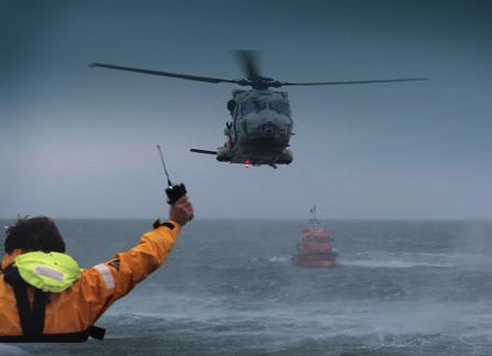
10 1010 GALILEO EGNOS EU SATELLITE NAVIGATION GALILEO SERVICES FROM INITIAL SERVICES TOWARDS FULL SERVICE LEVELS Like the internet, satellite navigation has become a technology on which we depend in our daily lives. With Galileo satellites working together with GPS, there will be more satellites available, meaning more accurate and reliable positioning for the end users. Galileo will be fully operational by 2020 and will offer five services: 1. GALILEO OPEN SERVICE (OS) The Galileo Open Service is Galileo s freely accessible service for positioning, navigation and timing. It will be used for many mass-market applications, including smartphones and in-car navigation. This service offers a very high accuracy of 30 nanoseconds which can be essential for critical infrastructure such as time synchronisation of the power grids or time-stamping of financial transactions. 2. GALILEO SEARCH AND RESCUE (SAR) The Galileo Search and Rescue (SAR) service is an important tool for locating people in distress. It provides a forward link for the detection of distress beacon and a unique return link message which allows the person in distress to know that help is on the way. This service is Europe s contribution to an international co-operative effort on search-and-rescue activities - known as COSPAS-SARSAT. Thanks to this service, the time it takes to detect a person lost at sea or in the mountains is reduced from three hours to just 10 minutes after a distress beacon is activated. 3. GALILEO PUBLIC REGULATED SERVICE (PRS) The Galileo Public Regulated Service (PRS) is an encrypted service designed for greater robustness and assured availability. The signal will be resistant to unintentional interference, malicious jamming, spoofing and meaconing. 4. GALILEO COMMERCIAL SERVICE (CS) The Galileo Commercial Service will deliver various addedvalue features, including a strong positioning service with high accuracy down to a few centimetres, and an authentication feature, allowing validation of signals and position. These unique characteristics will allow development of new applications taking advantage of previously unavailable SatNav system capabilities. 5. GALILEO'S CONTRIBUTION TO INTEGRITY-MONITORING SERVICES The contribution to Integrity-monitoring Services will be aimed at users of safety of life applications that are in compliance with international standards.


11 FOTOLIA FOTOLIA EU SATNAV 11
12 1212 GALILEO EGNOS EU SATELLITE NAVIGATION GALILEO APPLICATION AREAS Innovative uses of satellite navigation are emerging in many fields. So how can you use Galileo? Here are some key areas with wide use of satnav applications: LOCATION BASED SERVICES: the high accuracy in positioning offered by Galileo will help you to find the fastest way to get where you need to go. All you need is a mobile telephone or a hand-held device. INTERNET OF THINGS (IOT): The Internet is central to an endless number of services on which we rely every day. IOT represents the next step towards the digitisation of our society and economy, where objects are interconnected by creating communication networks though data exchange. Thanks to Galileo's signals accuracy and availability, users will enjoy an even wider and stronger data network. TRANSPORT: Travelling by plane, train, boat or by car, Galileo will make transport safer and more comfortable whether it is by identifying traffic jams or reducing travelling time and costs for the transport industry, transport will be optimised with Galileo. AVIATION: The Galileo system will ease air-trafficcontrol operations, increase traffic safety and efficiency and reduce costs of infrastructure management and operations. MARITIME: Galileo improves safety at sea. By performing ship-to-ship coordination, tracking containers and helping boats in port, approaching manoeuvres will be even more precise thanks to Galileo's signals. In 2016, the International Maritime Organisation (IMO) officially recognised Galileo, marking an important milestone for the adoption of Galileo for use in commercial shipping. AGRICULTURE: Want to boost crop yields while maintaining a money-saving and an environmentfriendly approach at the same time? Thanks to precise positioning, Galileo can help you work out just the right amount of seeds to sow, how much fertilisers to use and optimise water resource management. SURVEYING, GEOMETRY: Galileo will enable the use of new surveying and civil engineering tools that are more accurate and reliable. This will boost productivity and reduce costs in a sector where a small error can have serious consequences. TIMING SERVICES: Galileo satellites have synchronized clocks that provide an extraordinary level of accuracy and deliver a critical timing signal, which is useful in many fields. In Finance, electronic banking and stock exchange transactions need certified time stamps. In the Energy field, accurate timing and positioning systems are necessary in the design, construction and operation of modern energy networks. Communication and in particular wireless telecommunication networks will use Galileo timing for network management, time tagging and synchronisation of frequency references.
13 WHY GALILEO? Satellite navigation applications are now numerous and varied and play key roles both in business and in the daily lives of citizens and communities. Independence in this area is important to the EU's economy: it is estimated that today some 11% of the EU's yearly GDP depends on the availability of satellite navigation technology. European access to reliable and accurate satellite navigation services is therefore essential. INDEPENDENCE AND CONTROL OVER CONTINUITY OF SERVICE Galileo represents independence for Europe in satellite navigation, a sector now extremely important for its economy and the well-being of its citizens. This means the ability to deliver and control a guaranteed global satellite navigation service, even if other systems become less precise or are switched off. SAFEGUARD PEOPLE WHOSE LIVES DEPEND ON SATELLITE NAVIGATION Galileo is a civil system, designed with the needs of the public sector in mind. The Galileo services will have a reserved capacity for governmental use only to support local community emergency services like the police or peace-keeping missions, and result in a fast response to any kind of emergency situations. STIMULATING EUROPEAN INNOVATION The tangible technological advances and general knowhow generated by years of research and development under the Galileo programme represent a wealth of resources for Europe and in particular European industry. European companies, including the many innovative small and medium-sized enterprises that generate so much of the world s economic activity, are now better equipped than ever to get down to business. Jobs and business are being created for companies of all sizes, while spin-offs, coming out of the technology being developed, can be used by entrepreneurs and researchers outside the space industry. INTERNATIONAL CO-OPERATION AND COMPATIBILITY Compatibility refers to the ability of global navigation satellite systems and the services they provide to be used together, providing better capabilities at the user level than would be achieved by relying solely on one system. Galileo will co-operate with other existing satellite navigation systems, so users everywhere, both in Europe and around the world, will see a real improvement in existing services, as well as a widening of the range of new and innovative products and services. THE ENVIRONMENT MATTERS Less pollution can be achieved thanks to the more efficient transport routes that Galileo allows for. With precision farming methods, considerable reduction in the use of fertilisers and chemicals can be reached and healthier food can be grown. Smart food production can be sustained with the help of Galileo to match the growing world populations. EU SATNAV 13

14 1414 GALILEO EGNOS EU SATELLITE NAVIGATION
15 EGNOS THE EUROPEAN REGIONAL SATELLITE-BASED AUGMENTATION SYSTEM Great acronyms have great responsibilities! EGNOS, the European Geostationary Navigation Overlay Service, is Europe's first concrete venture into satellite navigation and the precursor to the Galileo programme. A regional satellite-based augmentation system (SBAS) like EGNOS can make information received from GPS, Galileo or other GNSS, even more accurate by correcting for errors such as those linked to ionospheric disturbances. Furthermore, EGNOS is able to check the integrity of the information received, by providing an alarm in case the position information is unreliable. This is fundamental for safety critical applications such as flying aircraft or navigating ships through narrow channels. EU SATNAV 15
 which receive signals from the GPS, Galileo or other GNSS satellites;")
16 1616 GALILEO EGNOS EU SATELLITE NAVIGATION THE EGNOS SYSTEM EXPLAINED The EGNOS system is made up of communication transponders aboard three geostationary satellites over Europe. The satellites are interconnected with an EGNOS ground network consisting of 40 ranging and integrity monitoring stations (RIMS) which receive signals from the GPS, Galileo or other GNSS satellites; 6 navigation land earth stations (NLES) that manage accuracy and reliability data for sending to the 3 satellite transponders for relay to end-user devices; 4 mission control centres (MCCs) that handle data processing and differential corrections counting. 3 GEOSTATIONARY SATELLITES 40 RANGING AND INTEGRITY MONITORING STATIONS 6 NAVIGATION LAND EARTH STATIONS 4 MISSION CONTROL CENTRES (MCCS) Enabled user devices receive the broadcast EGNOS signals in addition to GPS or Galileo signals, and can make use of the received information to significantly improve accuracy and reliability.

17 HOW DOES EGNOS WORK? EGNOS GEOSTATIONARY 5 SATELLITES GPS 1 EGNOS Improve Position Accuracy Provides Position integrity ERROR IN EGNOS POSITION ERROR IN GPS POSITION NLES UPLINK STATIONS MCC MISSION CONTROL CENTRES RIMS GNSS STATION EU SATNAV 17
18 1818 GALILEO EGNOS EU SATELLITE NAVIGATION WAAS The USA uses the Wide Area Augmentation System (WAAS). EGNOS & OTHER SBAS All satellite-based augmentation systems (SBAS) are interoperable, so with the same receiver, users can benefit from augmentation of satellite navigation everywhere in the world.
19 EGNOS The European Geostationary Navigation Overlay Service (EGNOS) covers Europe and neighbouring countries. SDCM Russia is active in the field with its GLONASS-based system called SDCM. GAGAN India has its own SBAS, GAGAN, which covers the Indian subcontinent. SNAS China is developing the SNAS system under its Beidou programme. MSAS Japan is covered by its Multifunctional Satellite Augmentation System (MSAS). EU SATNAV 19


20 2020 GALILEO EGNOS EU SATELLITE NAVIGATION


: This terrestrial commercial data service has been operational since 2012.")
21 EGNOS - THREE SERVICES ON STREAM SINCE 2009 Thanks to EGNOS, impressive performance levels can be obtained. The accuracy of positioning is improved up to 1 and 2 meters horizontally and between 2 and 4 meters vertically and the accuracy of timing information services is improved to better than 10 nanoseconds. 1. EGNOS OPEN SERVICE (OS) is available since October 2009 and is offered free of charge to anyone with a receiver compatible with satellitebased augmentation systems. 2. EGNOS SAFETY-OF-LIFE SERVICE (SOL) was launched in March 2011 for civil aviation, providing an indispensable alarm to users within six seconds in case of a GPS or Galileo malfunction. When lives are potentially at stake, such a warning is indispensable. 3. EGNOS DATA ACCESS SERVICE SERVICE (EDAS): This terrestrial commercial data service has been operational since EGNOS signals are made available through a dedicated internet connection. All information collected and generated by EGNOS is also available through a ground network, meaning that in situations where satellite signals are blocked or disturbed, the information can still be accessed. This is especially relevant in dense cities where tall buildings can block the EGNOS signals. EU SATNAV 21

22 222 GALILEO EGNOS EU SATELLITE NAVIGATION EGNOS APPLICATIONS AREAS AVIATION Global satellite navigation systems alone do not meet the necessary operational requirements set by the civil aviation authorities. EGNOS has been certificated for civil aviation use since Today, more than 200 airports in almost 20 European countries have EGNOS-based landing approach procedures and the number is increasing. Access to smaller and regional airports is improving. AGRICULTURE Precision farming techniques based on EGNOS are used by farmers across Europe to reduce the use of fertilisers and lower costs whilst benefiting the environment. MARITIME EGNOS is able to improve every aspect of maritime operations: from port and coast guard operations to offshore exploration and fisheries management. Maritime users can benefit from the better accuracy for harbour navigation or inland navigation. MAPPING The efficient technology of EGNOS contributes to improvement of any GNSS measurements with real time mapping information and solutions provided for free. ROAD/RAIL Terrestrial (Road/Rail) users can benefit from EGNOS enabled tracking systems. Accuracy in localisation is essential for both private and public sectors: it implies more fuel-efficient itineraries, better managed logistics and a fast response to any kind of emergency by the local community emergency services.

23 EU SATNAV 23

24 2424 GALILEO EGNOS EU SATELLITE NAVIGATION FACTS & FIGURES WITH EVERY 100 MILLION INVESTED IN THE AEROSPACE SECTOR, GDP IN EUROPE WILL INCREASE BY 70 MILLION IN OTHER SECTORS. Global navigation satellite system is a service enabler rather than a standalone service, therefore it acts as a catalyst for economic activities leading to the creation of added value and jobs in a wide range of sectors. Have you ever heard of the spill-over effect? It occurs when progresses that come about as a result of research and development (R&D) investment in the space industry are transferred to other sectors. Research suggests that investment by the aerospace sector could generate a social return of around 70%. In other words, with every 100 million invested in the R&D sector, GDP in Europe will increase by 70 million in other sectors e.g. health and medicine, transport, computer science. TOTAL ANNUAL GLOBAL MARKET VALUE FOR GLOBAL NAVIGATION SATELLITE PRODUCTS AND SERVICES : 175 BILLION IN BILLION IN 2020 THE EUROPEAN SPACE INDUSTRY EMPLOYS OVER PROFESSIONALS.

25 BY 2019, 7.0 BILLION GNSS DEVICES WILL BE IN USE WORLDWIDE. 3.6 billion GNSS devices are in use in 2014 worldwide. By 2019, this is forecasted to increase to over 7 bln for an average of one device per person on the planet. 2 DAY DISRUPTION = 1 BILLION. It has been estimated that a 2-day disruption to the satellite navigation services could cost the transport, finance and financial sectors across Europe 1 billion. ECALL From April 2018, all new type approved vehicles sold in Europe will be Galileo capable as part of a requirement to comply with the EU s ecall emergency response system regulation. Galileo-enabled navigation devices for your car will also start coming on the market in Satellite navigation, combined with 3-D sounds is being used to enable visually impaired people to use a new system of sensorial guidance in order to indicate to the user the correct path that is clear of obstacles. EGNOS and Galileo can fulfil the increasing demand for traceability from consumers and food regulators, which means that you would be able to scan a sack of potatoes at a supermarket and be able to tell from which field those potatoes came from by using geo-traceability. EU SATNAV 25

26 2626 GALILEO EGNOS EU SATELLITE NAVIGATION GOVERNANCE The Galileo and EGNOS programmes are funded and owned by the EU. The European Commission has the overall responsibility for the programmes, managing and overseeing the implementation of all programme activities on behalf of the EU. The deployment, design and development of the new generation of systems and the technical development of infrastructure of the programmes are entrusted to the European Space Agency (ESA). The operational management of Galileo and EGNOS are carried out by an EU agency, the European Global Navigation Satellite Systems Agency (GSA).

27 More info The European Commission webpages: The European Global Navigation Satellite System Agency GSA The European GNSS Service Centre (GSC) helpdesk for users: The European Space Agency ESA The EGNOS portal: EU SATNAV 27
28
Galileo will boost economy and make life of citizens easier
 MEMO/11/717 Brussels, 21 October 2011 Galileo will boost economy and make life of citizens easier A Must have for Europe "If Europe really wants to be considered as a serious partner by the United States
The Mid-term Review of the European Satellite Radio Navigation Programmes Galileo and EGNOS: Questions and Answers
 MEMO/11/26 Brussels, 18 th January 2011 The Mid-term Review of the European Satellite Radio Navigation Programmes Galileo and EGNOS: Questions and Answers See also IP/11/42 For the full text of the Communication
The European Satellite Radio Navigation Programmes Galileo and EGNOS: Questions and Answers
 MEMO/11/326 Brussels, 23 May 2011 The European Satellite Radio Navigation Programmes Galileo and EGNOS: Questions and Answers What is satellite navigation? Satellite navigation is based on the principle
Overview of the global GNSS market and status of Galileo
 2012 GNSS.asia workshop Overview of the global GNSS market and status of Galileo 6 November, 2012 Taipei Justyna Redelkiewicz, European GNSS Agency European GNNS Agency supports European Commission in
The Galileo and EGNOS Programmes
 The Galileo and EGNOS Programmes Dominic Hayes European Commission ignss, Gold Coast, 14 July 2015 The European GNSS Programmes 2 Organisation and Contractual Frameworks European Union Member States (28)
Galileo & EGNOS Programmes Status
 Galileo & EGNOS Programmes Status Ugo Celestino, European Commission EURO-MEDITERRANEAN TRANSPORT FORUM GNSS WORKING GROUP 16 th October 2012 17 October, 2012 The European GNSS Programmes 2 Table of contents
European GNSS Applications in H2020
 European GNSS Applications in H2020 Countdown to H2020 12.12.2013, Brussels Carmen Aguilera European GNSS Agency Agenda European GNSS Agency EU-GNSS market potential FP7- experience and results H2020 opportunities
ESA/CNES/ARIANESPACE Service Optique CSG, S. Martin. IGNSS 2018 Sydney
 ESA/CNES/ARIANESPACE Service Optique CSG, S. Martin IGNSS 2018 Sydney GALILEO SERVICES Open Service (OS) Freely accessible service for positioning, navigation and timing Public Regulated Service (PRS)
The EU Satellite Navigation programmes status Applications for the CAP
 The EU Satellite Navigation programmes status Applications for the CAP Michaël MASTIER European Commission DG ENTR GP3 GNSS Applications, Security and International aspects GPS Workshop 2010 Montpellier
Lecture-1 CHAPTER 2 INTRODUCTION TO GPS
 Lecture-1 CHAPTER 2 INTRODUCTION TO GPS 2.1 History of GPS GPS is a global navigation satellite system (GNSS). It is the commonly used acronym of NAVSTAR (NAVigation System with Time And Ranging) GPS (Global
GNSS Programme. Overview and Status in Europe
 GNSS Programme Overview and Status in Europe Inaugural Forum Satellite Positioning Research and Application Center 23 April 2007 Tokyo Presented by Thomas Naecke (European Commission) Prepared by Daniel
Status of the European EGNOS and Galileo Programmes. Frank Udnaes Galileo policy and Infrastructure group EC DG-TREN. June 2008
 Status of the European EGNOS and Galileo Programmes Frank Udnaes Galileo policy and Infrastructure group EC DG-TREN EUROPEAN COMMISSION z June 2008 Galileo An infrastructure 30 satellite Constellation
ESA/CNES/ARIANESPACE-Service Optique CSG, S. Martin ABUJA, OCTOBER 2018
 ESA/CNES/ARIANESPACE-Service Optique CSG, S. Martin ABUJA, OCTOBER 2018 GALILEO - SOME KEY FEATURES CIVIL Not managed by Defence DUAL FREQUENCY (L1/L5 ) Less impact from solar conditions/ionosphere DIGITAL
RESPONSE TO THE HOUSE OF COMMONS TRANSPORT SELECT COMMITTEE INQUIRY INTO GALILEO. Memorandum submitted by The Royal Academy of Engineering
 RESPONSE TO THE HOUSE OF COMMONS TRANSPORT SELECT COMMITTEE INQUIRY INTO GALILEO Memorandum submitted by The Royal Academy of Engineering September 2004 Executive Summary The Royal Academy of Engineering
Satellite navigation applications: opportunities from the European GNSS. Fiammetta Diani Deputy Head of Market Development European GNSS Agency
 Satellite navigation applications: opportunities from the European GNSS Fiammetta Diani Deputy Head of Market Development European GNSS Agency FP7 success story in Lithuania COSUDEC Coastal Surveying of
Global navigation satellite systems (GNSS) - European Galileo system
 - European Galileo system") L E C T U R E 5 Global navigation satellite systems (GNSS) - European Galileo system Lecture 5 Overview Galileo GNSS Development Architecture Principle EGNOS GNSS applications GALILEO system GALILEO system
L E C T U R E 5 Global navigation satellite systems (GNSS) - European Galileo system Lecture 5 Overview Galileo GNSS Development Architecture Principle EGNOS GNSS applications GALILEO system GALILEO system
Challenges and Solutions for GPS Receiver Test
 Challenges and Solutions for GPS Receiver Test Presenter: Mirin Lew January 28, 2010 Agenda GPS technology concepts GPS and GNSS overview Assisted GPS (A-GPS) Basic tests required for GPS receiver verification
The topic we are going to see in this unit, the global positioning system, is not directly related with the computer networks we use everyday, but it
 The topic we are going to see in this unit, the global positioning system, is not directly related with the computer networks we use everyday, but it is indeed a kind of computer network, as the specialised
SATELLITE BASED AUGMENTATION SYSTEM (SBAS) FOR AUSTRALIA
 FOR AUSTRALIA") SATELLITE BASED AUGMENTATION SYSTEM (SBAS) FOR AUSTRALIA AN AIN POSITION PAPER SUBMITTED TO VARIOUS GOVERNMENT DEPARTMENTS BY MR KYM OSLEY AM, CSC, EXEC SECRETARY AIN What are GNSS Augmentation Systems?
SATELLITE BASED AUGMENTATION SYSTEM (SBAS) FOR AUSTRALIA AN AIN POSITION PAPER SUBMITTED TO VARIOUS GOVERNMENT DEPARTMENTS BY MR KYM OSLEY AM, CSC, EXEC SECRETARY AIN What are GNSS Augmentation Systems?
European GNSS Evolution
 Ref. Ares(204)902599 - /06/204 European GNSS Evolution Hermann Ebner Galileo and EGNOS Programme Management DG Enterprise and Industry Content Introduction 2 2 Major Challenges for EGNSS Evolution 3 EGNSS
IMO WORLD-WIDE RADIONAVIGATION SYSTEM (WWRNS) GALILEO receiver performance standards. Submitted by the European Commission
 GALILEO receiver performance standards. Submitted by the European Commission") INTERNATIONAL MARITIME ORGANIZATION E IMO SUB-COMMITTEE ON SAFETY OF NAVIGATION 50th session Agenda item 13 2 April 2004 Original: ENGLISH WORLD-WIDE RADIONAVIGATION SYSTEM (WWRNS) GALILEO receiver performance
INTERNATIONAL MARITIME ORGANIZATION E IMO SUB-COMMITTEE ON SAFETY OF NAVIGATION 50th session Agenda item 13 2 April 2004 Original: ENGLISH WORLD-WIDE RADIONAVIGATION SYSTEM (WWRNS) GALILEO receiver performance
Nigerian Communications Satellite Ltd. (NIGCOMSAT)
") OVERVIEW OF NIGERIAN SATELLITE AUGMENTATION SYSTEM COMMENCING WITH PILOT DEMONSTRATION TO VALIDATE NATIONAL WORK PLAN presented by Dr. Lawal Lasisi Salami, NIGERIAN COMMUNICATIONS SATELLITE LTD UNDER FEDERAL
OVERVIEW OF NIGERIAN SATELLITE AUGMENTATION SYSTEM COMMENCING WITH PILOT DEMONSTRATION TO VALIDATE NATIONAL WORK PLAN presented by Dr. Lawal Lasisi Salami, NIGERIAN COMMUNICATIONS SATELLITE LTD UNDER FEDERAL
The European Satellite Navigation Programmes EGNOS and Galileo
 The European Satellite Navigation Programmes EGNOS and Galileo Santiago Soley on behalf of the European Commission Bogotá, 7 November 2012 13 May, 2013 The European GNSS Programmes 2 Table of contents
GALILEO READY TO LINK WITH INSPIRE
 GALILEO READY TO LINK WITH INSPIRE INSPIRE CONFERENCE 2016 Barcelona 28 September 2016 Alina Hriscu Market Development European GNSS Agency (GSA) Agenda European GNSS Agency (GSA) E GNSS Services, Signals
GBAS FOR ATCO. June 2017
 GBAS FOR ATCO June 2017 Disclaimer This presentation is for information purposes only. It should not be relied on as the sole source of information, and should always be used in the context of other authoritative
GSA GNSS Technology Report Main highlights IPIN 2018
 GSA GNSS Technology Report Main highlights IPIN 2018 Justyna Redelkiewicz, European GNSS Agency 25 September 2018, Nantes The European GNSS Agency (GSA) is responsible for market development and operations
Galileo and the future of SatNav: monitoring the market and technology opportunities
 Galileo and the future of SatNav: monitoring the market and technology opportunities Alberto Fernández Wyttenbach, Market Innovation Officer ESA Space Moves! 18 th September 2017, Berlin GSA governance
GNSS Programmes and R&D landscape in the EU
 GNSS Programmes and R&D landscape in the EU Ignacio Fernández Hernández European Commission - DG ENTR GP1 ICL-GNSS, Tampere, 30 June 2011 Navigation solutions powered by Europe Objectives Give an overview
Protection Augmentation Toughness and Alternatives of GNSS. Melaha 2016 Concord Al-Salam Hotel Cairo, April 25,2016 Refaat Rashad
 Protection Augmentation Toughness and Alternatives of GNSS Melaha 2016 Concord Al-Salam Hotel Cairo, April 25,2016 Refaat Rashad Road Map of the Presentation 1- How Good are GNSS 2- How Vulnerable are
EGNOS/GALILEO Status. Rafael Lucas Navigation Applications and User Services Office European Space Agency
 EGNOS/GALILEO Status Rafael Lucas Navigation Applications and User Services Office European Space Agency Rafael.Lucas.Rodriguez@esa.int European Satellite Navigation Strategy GNSS1: EGNOS Civil complement
EGNOS Operations Oper and T and heir T Planned Ev E olution v
 EGNOS Operations a Th P Evo EGNOS Laurent Gauthier, Javier Ventura-Traveset, Felix Toran Navigation Department, ESA Directorate of European Union and Industrial Programmes, Toulouse, France Chantal de
GNSS Training for ITS Developers. Characterisation of EGNSS performances in relationship with the application requirements
 GNSS Training for ITS Developers Characterisation of EGNSS performances in relationship with the application requirements Table of Content egnss for Application: Main Challenges EGNOS and GALILEO Performances
UPDATE ON GALILEO DEVELOPMENTS AND THE AVAILABLE SERVICES
 UPDATE ON GALILEO DEVELOPMENTS AND THE AVAILABLE SERVICES 3 rd EUPOS Council and Technical Meeting The third meeting of the Positioning Knowledge Exchange Network (PosKEN) Prague, The Czech Republic 14-16
Global Navigation Satellite Systems (GNSS)
") Global Navigation Satellite Systems (GNSS) Pat Norris MRAeS, FRIN LogicaCMG Business Development Manager Chairman, RAeS Space Group LogicaCMG 2006. All rights reserved 2 Global Navigation Satellite Systems
Global Navigation Satellite Systems (GNSS) Pat Norris MRAeS, FRIN LogicaCMG Business Development Manager Chairman, RAeS Space Group LogicaCMG 2006. All rights reserved 2 Global Navigation Satellite Systems
Galileo Aktueller Stand der Entwicklung
 Galileo Aktueller Stand der Entwicklung Is there a positive perspective for Galileo? Dr. Philipp Berglez TeleConsult Austria GmbH GSV-Forum Galileo das europäische Satellitennavigationssystem eine neue
EUROPEAN GNSS ADOPTION OPPORTUNITIES IN TRANSPORT WITH FOCUS ON RAIL
 EUROPEAN GNSS ADOPTION OPPORTUNITIES IN TRANSPORT WITH FOCUS ON RAIL Gian Gherardo Calini European GNSS Agency III Workshop GNSS Technology Advances in a Multi-Constellation Framework 22 January 2016 This
Galileo Programme Update Market opportunities for E-GNSS
 Galileo Programme Update Market opportunities for E-GNSS Rodrigo da Costa, Galileo Exploitation Programme Manager 21 September 2017, Lisbon Agenda European GNSS Agency (GSA) Overiview Galileo Services
Galileo. Opportunities and Challenges by Gard Ueland. November 22, 2011, Brussels. Secure World Foundation Conference. Chairman Galileo Services
 Galileo Opportunities and Challenges by Gard Ueland Chairman Galileo Services Secure World Foundation Conference The Brussels Space Policy Round Table - Galileo November 22, 2011, Brussels Galileo Launch
Introduction to GNSS opportunities in different Market Segments. Fiammetta Diani Market Development
 Introduction to GNSS opportunities in different Market Segments Fiammetta Diani Market Development fiammetta.diani@gsa.europa.eu 3-Mar-14 European GNSS Agency 2 Congratulations! Agenda European GNSS market
Indian GNSS Industry Overview Challenges and future prospects
 Indian GNSS Industry Overview Challenges and future prospects Expert Presentation By Dr. S.V. Kibe Consultant, SATCOM & GNSS, Bangalore, India (Former Programme Director, SATNAV,ISRO HQ) On February 20,2013
Principal Investigator Co-Principal Investigator Co-Principal Investigator Prof. Talat Ahmad Vice-Chancellor Jamia Millia Islamia Delhi
 Subject Paper No and Title Module No and Title Module Tag Geology Remote Sensing and GIS Concepts of Global Navigation Satellite RS & GIS XXXIII Principal Investigator Co-Principal Investigator Co-Principal
PRELIMINARY PROGRAMME
 ICG EXPERTS MEETING: GLOBAL NAVIGATION SATELLITE SYSTEMS SERVICES 14-18 December 2015 Vienna International Centre, Vienna, Austria Organized by International Committee on Global Navigation Satellite Systems
Galileo Programme Update
 Galileo Programme Update Pieter De Smet, European Commission ICTP Conference, Prague, 10 November, 2014 1 December 2014 The European GNSS Programmes 2 Secure Foundations ü A stable 7 years perspective
GALILEO AND EGNOS VALUE PROPOSITION FOR E112
 Ref. Ares(2014)1665692-22/05/2014 GALILEO AND EGNOS VALUE PROPOSITION FOR E112 Fiammetta Diani, Justyna REDELKIEWICZ European GNSS Agency (GSA) Brussels, 07/05/2014 Agenda European GNSS Agency at a glance
ASSEMBLY 37TH SESSION
 International Civil Aviation Organization WORKING PAPER A37-WP/195 1 22/9/10 (Information paper) ASSEMBLY 37TH SESSION TECHNICAL COMMISSION Agenda Item 35: The Global Air Traffic Management (ATM) System
FAST AND LIABLE CARTOGRAPHY UPDATE USING EGNOS AND GALILEO
 (1) (2) FAST AND LIABLE CARTOGRAPHY UPDATE USING EGNOS AND GALILEO Manuel Toledo (1), Angel Gavín (2) GMV S.A., Isaac Newton 11, P.T.M. Tres Cantos, 28760 Madrid, Spain, E-mail: mtoledo@gmv.es; agavin@gmv.es
Precise Positioning... what does it mean? Precise GNSS Positioning Not just a niche technology. Chris Rizos 15/12/15
 Precise GNSS Positioning Not just a niche technology Chris Rizos Precise Positioning... what does it mean? 1 Precise Positioning... a spectrum of users... Few mm 1cm 2cm < dm 1dm sub-m Precision agriculture
Presented at the FIG Working Week 2017, May 29 - June 2, 2017 in Helsinki, Finland
 Presented at the FIG Working Week 2017, May 29 - June 2, 2017 in Helsinki, Finland FIG Working Week 2017 European GNSS for Surveying and Mapping Reinhard Blasi, Alina Hriscu Market Development, European
The last 25 years - GPS to multi-gnss: from a military tool to the most widely used civilian positioning solution
 1 The last 25 years - GPS to multi-gnss: from a military tool to the most widely used civilian positioning solution B. Hofmann-Wellenhof Institute of Geodesy / Navigation, Graz University of Technology
SBAS solution GCC, Yemen and Iraq System baseline and performance
 SBAS solution GCC, Yemen and Iraq System baseline and performance ACAC Workshop Rabat 7 & 8 November 2017 1 2017 Thales Alenia Space PROPRIETARY C O M MINFORMATION E R C I A L I N THALES C O ALENIA N F
Satellite-Based Augmentation System (SBAS) Integrity Services
 Integrity Services") Satellite-Based Augmentation System (SBAS) Integrity Services Presented To: Munich, Germany Date: March 8, 2010 By: Leo Eldredge, Manager GNSS Group, FAA FAA Satellite Navigation Program 2 Wide Area Augmentation
Satellite-Based Augmentation System (SBAS) Integrity Services Presented To: Munich, Germany Date: March 8, 2010 By: Leo Eldredge, Manager GNSS Group, FAA FAA Satellite Navigation Program 2 Wide Area Augmentation
GLObal Navigation Satellite System (GLONASS)
") FEDERAL SPACE AGENCY GLObal Navigation Satellite System (GLONASS) Sergey Revnivykh Deputy Director General Central Research Institute of Machine Building Head of PNT Center 4-th meeting of International
FEDERAL SPACE AGENCY GLObal Navigation Satellite System (GLONASS) Sergey Revnivykh Deputy Director General Central Research Institute of Machine Building Head of PNT Center 4-th meeting of International
Galileo. 7th ITFS, Rome, Italy, 3-5 November Dr. Stefan Bedrich. Kayser-Threde GmbH Wolfratshauser Str Munich
 Kayser-Threde GmbH Wolfratshauser Str. 48 81379 Munich spacetech@kayser-threde.com Galileo 7th ITFS, Rome, Italy, 3-5 November 2009 Dr. Stefan Bedrich w w w. k a y s e r - t h r e d e. c o m Outline Motivation
Positioning, location data and GNSS as solution for Autonomous driving
 Positioning, location data and GNSS as solution for Autonomous driving Jarkko Koskinen, Heidi Kuusniemi, Juha Hyyppä, Sarang Thombre and Martti Kirkko-Jaakkola FGI, NLS Definition of the Arctic 66 34 N
GALILEO Applications. Andreas Schütz Training on GNSS T131 / T151 Bangkok, January 14th 2019
 GALILEO Applications Andreas Schütz Training on GNSS T131 / T151 Bangkok, January 14th 201 Overview GNSS Downstream Applications overview The GALILEO Open Service The GALILEO Public Regulated Service The
Galileo - European Global Navigation Satellite System
 Abstract Galileo - European Global Navigation Satellite System Wu Chen Department of Land Surveying and Geoinformatics Hong Kong Polytechnic University e-mail: Lswuchen@polyu.du.hk Washington Yotto Ochieng
EGNOS status and performance in the context of marine navigation requirements
 EGNOS status and performance in the context of marine navigation requirements J. Cydejko Gdynia Maritime University, Gdynia, Poland ABSTRACT: The current status of EGNOS (December 2006) is described as
One Source for Positioning Success
 novatel.com One Source for Positioning Success RTK, PPP, SBAS OR DGNSS. NOVATEL CORRECT OPTIMIZES ALL CORRECTION SOURCES, PUTTING MORE POWER, FLEXIBILITY AND CONTROL IN YOUR HANDS. NovAtel CORRECT is the
An Introduction to Airline Communication Types
 AN INTEL COMPANY An Introduction to Airline Communication Types By Chip Downing, Senior Director, Aerospace & Defense WHEN IT MATTERS, IT RUNS ON WIND RIVER EXECUTIVE SUMMARY Today s global airliners use
What s new in satellite navigation for road. Fiammetta Diani, Deputy Head Market Development Department European GNSS Agency
 What s new in satellite navigation for road Fiammetta Diani, Deputy Head Market Development Department European GNSS Agency May 2017 Why location (and satellite navigation) matters? 2 Galileo is the Satellite
European Geostationary Navigation Overlay Service (EGNOS) Capability on Sirius 5 Satellite for SES
 Capability on Sirius 5 Satellite for SES") 21 October 2009 SES SIRIUS European Geostationary Navigation Overlay Service (EGNOS) Capability on Sirius 5 Satellite for SES Mike Pavloff, Executive Director, Space Systems/Loral Information included
21 October 2009 SES SIRIUS European Geostationary Navigation Overlay Service (EGNOS) Capability on Sirius 5 Satellite for SES Mike Pavloff, Executive Director, Space Systems/Loral Information included
King AbdulAziz University. Faculty of Environmental Design. Geomatics Department. Mobile GIS GEOM 427. Lecture 3
 King AbdulAziz University Faculty of Environmental Design Geomatics Department Mobile GIS GEOM 427 Lecture 3 Ahmed Baik, Ph.D. Email: abaik@kau.edu.sa Eng. Fisal Basheeh Email: fbasaheeh@kau.edu.sa GNSS
CONSIDERATIONS FOR GNSS MEASUREMENTS
 CONSIDERATIONS FOR GNSS MEASUREMENTS Cornel PĂUNESCU 1, Cristian VASILE 2, Cosmin CIUCULESCU 3 1 PhD University of Bucharest, e-mail: cornelpaun@gmail.com 2 Lecturer PhD University of Craiova, cristi_vasile_4you@yahoo.com
European GNSS: Galileo and EGNOS for next generation Road Charging
 European GNSS: Galileo and EGNOS for next generation Road Charging 20 th October 2014 Gian Gherardo Calini European GNSS Agency (GSA) GNSS have made a huge impact in our society it is key in Road transportation
Overview of Galileo & EGNOS
 Overview of Galileo & EGNOS Ugo Celestino, European Commission GNSS Working Group 6 th Meeting, Brussels, 25 th September 2013 26 September, 2013 Overview of Galileo & EGNOS 2 Europe needs Galileo Galileo
Experience with Radio Navigation Satellite Service (RNSS)
") Experience with Radio Navigation Satellite Service (RNSS) International Satellite Communication Symposium International Telecommunication Union (ITU) Geneva, 13-14 June 2016 MITOME, Takahiro Co-Chair of
Experience with Radio Navigation Satellite Service (RNSS) International Satellite Communication Symposium International Telecommunication Union (ITU) Geneva, 13-14 June 2016 MITOME, Takahiro Co-Chair of
Galileo Information Center for Latin America / Application of the ISMR Query Tool in the analysis of Ionospheric Scintillation from Galileo Satellites
 Galileo Information Center for Latin America / Application of the ISMR Query Tool in the analysis of Ionospheric Scintillation from Galileo Satellites Bruno César Vani Programa de Pós-graduação em Ciências
Timing & Synchronisation
 Timing & Synchronisation With an analysis of GNSS User Technology ISSUE 4 Excerpt from the GNSS MARKET REPORT, ISSUE 4 (2015) 72 Timing & Synchronisation GNSS applications This chapter addresses the following
Overview of Localisation Technologies
 ASK-IT for Technical Providers Overview of Localisation Technologies With RFID/Smartdust and Galileo 13 th October 2005 - Stuttgart Richard Fairchild r.g.fairchild@ncl.ac.uk School of Civil Engineering
GALILEO Research and Development Activities. Second Call. Area 3. Statement of Work
 GALILEO Research and Development Activities Second Call Area 3 Innovation by Small and Medium Enterprises Statement of Work Rue du Luxembourg, 3 B 1000 Brussels Tel +32 2 507 80 00 Fax +32 2 507 80 01
WELCOME TO Galileo: At the Dawn of a New Age of GNSS Services
 Mapping from UAVs WELCOME TO Galileo: At the Dawn of a New Age of GNSS Services Marco Lisi, Dr. eng. Senior Manager European Space Agency Jeremie Godet Head of Sector Galileo Implementation DG GROW European
VIIIth European Interparliamentary Space. Mr. Rainer Grohe Executive Director Galileo Joint Undertaking
 The European Institutional Framework for Galileo VIIIth European Interparliamentary Space Conference Mr. Rainer Grohe Executive Director Galileo Joint Undertaking Brussels, 12th June 2006 Galileo Architecture
GLOBAL POSITIONING SYSTEMS. Knowing where and when
 GLOBAL POSITIONING SYSTEMS Knowing where and when Overview Continuous position fixes Worldwide coverage Latitude/Longitude/Height Centimeter accuracy Accurate time Feasibility studies begun in 1960 s.
GNSS VULNERABILITY AND CRITICAL INFRASTRUCTURE
 GNSS VULNERABILITY AND CRITICAL INFRASTRUCTURE NNF CONFERENCE 24 MAY 2012 Brynjar Hansen Senior adviser Norwegian Space Centre Lars Giske Senior adviser Norwegian Space Centre MULTI GNSS EXTERNAL COOPERATION
CLICK HERE TO KNOW MORE
 CLICK HERE TO KNOW MORE Should GNSS Become a National Critical Infrastructure? Ooi Wei Han, Noordin Ahmad, Shahrizal IM National Space Agency (ANGKASA) Ministry of Science, Technology and Innovation (MOSTI)
Over the past 30 years
 GNSS applications for agricultural practices Application by Guy Blanchard Ikokou, University of Cape Town Global positioning systems are relatively new technologies when it comes to applications in agriculture.
GLOBAL POSITIONING SYSTEMS
 GLOBAL POSITIONING SYSTEMS Maps & Geospatial Concepts Fall 2015 Before GPS Historical look at navigation Giant concrete arrows that point your way across America What are these giant arrows? Some kind
The International Scene: How Precise Positioning Will Underpin Critical GNSS Applications
 The International Scene: How Precise Positioning Will Underpin Critical GNSS Applications School of Civil & Environmental Engineering, UNSW, Sydney, Australia Chris Rizos Member of the IGS Governing Board
«Current state and prospects of development of commercial application GLONASS/GNSS in the Russian Federation»
 «Current state and prospects of development of commercial application GLONASS/GNSS in the Russian Federation» United Nations SYMPOSIUM TO STRENGTHEN THE PARTNERSHIP WITH INDUSTRY COMMERCIAL APPLICATIONS
Developments in Satellite Navigation and Wireless Spectrum
 Developments in Satellite Navigation and Wireless Spectrum Chris Hegarty 14 June 2010 Christopher J. Hegarty, D.Sc. The MITRE Corporation chegarty@mitre.org 781-271-2127 (Tel) The contents of this material
GE 113 REMOTE SENSING
 GE 113 REMOTE SENSING Topic 9. Introduction to Global Positioning Systems (GPS) and Other GNSS Technologies Lecturer: Engr. Jojene R. Santillan jrsantillan@carsu.edu.ph Division of Geodetic Engineering
GLOBAL NAVIGATION SATELLITE SYSTEMS (GNSS) ECE 2526E Tuesday, 24 April 2018
 ECE 2526E Tuesday, 24 April 2018") GLOBAL NAVIGATION SATELLITE SYSTEMS (GNSS) ECE 2526E Tuesday, 24 April 2018 MAJOR GLOBAL NAVIGATION SATELLITE SYSTEMS (GNSS) Global Navigation Satellite System (GNSS) includes: 1. Global Position System
GLOBAL NAVIGATION SATELLITE SYSTEMS (GNSS) ECE 2526E Tuesday, 24 April 2018 MAJOR GLOBAL NAVIGATION SATELLITE SYSTEMS (GNSS) Global Navigation Satellite System (GNSS) includes: 1. Global Position System
UPDATE ON EGNOS AND GALILEO
 UPDATE ON EGNOS AND GALILEO Riga CLGE GA 23 September 2016 Alina Hriscu Market Development European GNSS Agency (GSA) This presentation can be interpreted only together with the oral comments accompanying
TEST YOUR SATELLITE NAVIGATION PERFORMANCE ON YOUR ANDROID DEVICE GLOSSARY
 TEST YOUR SATELLITE NAVIGATION PERFORMANCE ON YOUR ANDROID DEVICE GLOSSARY THE GLOSSARY This glossary aims to clarify and explain the acronyms used in GNSS and satellite navigation performance testing
Galileo. Development Status. Navigare'09 à Neuchâtel DR. MARTIN HOLLREISER GALILEO PROJECT OFFICE - EUROPEAN SPACE AGENCY
 Galileo Development Status DR. MARTIN HOLLREISER GALILEO PROJECT OFFICE - EUROPEAN SPACE AGENCY Munich Satellite Navigation Summit 2009 Navigare'09 à Neuchâtel Programme Phases 2011-2013 4 GIOVE A/B IOV
ORBITAL NAVIGATION SYSTEMS PRESENT AND FUTURE TENDS
 ORBITAL NAVIGATION SYSTEMS PRESENT AND FUTURE TENDS CONTENT WHAT IS COVERED A BRIEF HISTORY OF SYSTEMS PRESENT SYSTEMS IN USE PROBLEMS WITH SATELLITE SYSTEMS PLANNED IMPROVEMENTS CONCLUSION CONTENT WHAT
GALILEO Research and Development Activities. Second Call. Area 3. Coordination of Galileo Research & Development activities.
 GALILEO Research and Development Activities Second Call Area 3 Coordination of Galileo Research & Development activities Statement of Work Rue du Luxembourg, 3 B 1000 Brussels Tel +32 2 507 80 00 Fax +32
EUROPEAN COMMISSION Mission High Level Definition
 Mission High Level Definition April 3, 2001 Issue 2.0, 3 rd April 2001 Table of Contents Abstract... 1 1. Introduction... 2 1.1 Scope and Objective of the Document... 2 1.2 Approval and Management of the
Scoping Paper for. Horizon 2020 work programme Leadership in Enabling and Industrial Technologies Space
 Scoping Paper for Horizon 2020 work programme 2018-2020 Leadership in Enabling and Industrial Technologies Space Important Notice: Working Document This scoping paper will guide the preparation of the
The Future of Search & Rescue. We Save Lives. Steve Waters SAFE Symposium 2016
 The Future of Search & Rescue We Save Lives Steve Waters SAFE Symposium 2016 Covering today.. Understanding the Search and Rescue Ecosystem Helios and GADSS Global Aeronautical Distress and Safety System
DEFINING THE FUTURE OF SATELLITE SURVEYING WITH TRIMBLE R-TRACK TECHNOLOGY
 DEFINING THE FUTURE OF SATELLITE SURVEYING WITH TRIMBLE R-TRACK TECHNOLOGY EDMOND NORSE, GNSS PORTFOLIO MANAGER, TRIMBLE SURVEY DIVISION WESTMINSTER, CO USA ABSTRACT In September 2003 Trimble introduced
New Funding Opportunities to Support Safety of Navigation: EGNOS and Galileo
 New Funding Opportunities to Support Safety of Navigation: EGNOS and Galileo e-navigation Underway 31 January-2 February 2017 GSA 2016 The European GNSS Agency (GSA) today: Staff: about 145 Nationalities:
The Future of Global Navigation Satellite Systems
 The Future of Global Navigation Satellite Systems Chris RIZOS School of Surveying & Spatial Information Systems University of New South Wales Sydney, NSW 2052, AUSTRALIA E-mail: c.rizos@unsw.edu.au Abstract
GNSS: orbits, signals, and methods
 Part I GNSS: orbits, signals, and methods 1 GNSS ground and space segments Global Navigation Satellite Systems (GNSS) at the time of writing comprise four systems, two of which are fully operational and
System Status and Performance Improvement Prospects
 Communication Геодезия Navigation GLOBAL NAVIGATION SATELLITE SYSTEM (GLONASS): System Status and Performance Improvement Prospects Viktor KOSENKO, First Deputy General Designer First Deputy General Director
Introduction to Galileo PRS
 Introduction to Galileo PRS Fabio Covello 20/09/2017 ESA UNCLASSIFIED - For Official Use Galileo mission figures The Galileo Space Segment: 30 satellites (full constellation) Walker 24/3/1 constellation
What is a GPS How does GPS work? GPS Segments GPS P osition Position Position Accuracy Accuracy Accuracy GPS A pplications Applications Applications
 What is GPS? What is a GPS How does GPS work? GPS Segments GPS Position Accuracy GPS Applications What is GPS? The Global Positioning System (GPS) is a precise worldwide radio-navigation system, and consists
Geoscience & Positioning, Navigation and Timing Services for Canadians
 Geoscience & Positioning, Navigation and Timing Services for Canadians Calvin Klatt, Ph.D. Director and Chief Geodesist Natural Resources Canada / Directeur et géodésien principal Ressources naturelles
GPS/WAAS Program Update
 GPS/WAAS Program Update UN/Argentina Workshop on the Applications of GNSS 19-23 March 2018 Cordoba, Argentina GNSS: A Global Navigation Satellite System of Systems Global Constellations GPS (24+3) GLONASS
Dimov Stojče Ilčev. CNS Systems
 Stratospheric Platform Systems (SPS) Presentation by: Dimov Stojče Ilčev Durban University of Technology (DUT) Space Science Centre (SSC) CNS Systems August 2011 SPS for Mobile CNS Applications Stratospheric