Dirty REMOTE SENSING Week 2 Interpreation
|
|
|
- Deborah Gallagher
- 6 years ago
- Views:
Transcription
1 Dirty REMOTE SENSING Week 2 Interpreation Earthobservation.wordpress.com Stuart Green Stuart.Green@teagasc.ie


2
3 AERIAL PHOTOGRAPHIC INTERPRETATION
4 Images of the earth are map like representations of the earth s surface based on reflections of electromagnetic energy from vegetation, soil, water, rocks, and structures. Yet such information is not presented to us directlythe information we seek is encoded in the various tones and textures we see on the image. To translate images into information we must apply a specialised knowledge-knowledge that forms the field of image interpretation, which we can apply to derive useful information from the raw, un-interpreted images we receive from remote sensing systems. These definations are taken from Campbell 2002: ontcover&source=gbs_navlinks_s#v=onepage&q=&f=false
5 What are we looking for? Knowledge of the subject :Accurate interpretation requires familiarity with the subject of the interpretation. Image interpreters should be equipped with a broad range of knowledge and experince across earth and biological sciences.
6 The Human Image Processing Continuum natural perception (looking) -> abduction (hunch) -> convention (experience/teaching)-> cognitive (Understanding) tml
7 First Questions Where am I Looking? What system took the image? When was it taken?
8 Remember. (1) Remotely sensed imagery usually presents an overhead view. (2) Many remote sensing images use radiation outside the visible portion of the spectrum. (3) Remote sensing images often portray the earth s surface at unfamiliar scales and resolutions.
9 Elements Tone/Colour Size, Shape & Texture Pattern, Shaddow Location, Context


10 1. Image Tone
11 2. Image Texture two definitions> Image texture refers to the apparent roughness or smoothness of an image in a region. Usually texture is caused by the pattern of highlighted and shadowed areas as an irregular surface is illuminated from an oblique angle. Image texture depends on the surface itself and the angle of illumination, so it can vary as lighting varies. Good rendition of texture depends on favourable image contrast, so images of poor or marginal quality may lack the distinct textural differences so valuable to the interpreter. Alt:Texture is the frequency of change and arrangement of tones. This is a micro image characteristic. The visual impression of smoothness or roughness of an area can often be a valuable clue in image interpretation. Still water bodies are typically fine textured, grass medium, brush rough. There are always exceptions though and scale can and does play a role; grass could be smooth, brush medium and forest rough on higher altitude aerial photograph of the same area.


12 Image Texture
13 3. Shadow Shadow is crucial in telling us about relative size and position


14 Shadow


15 Relief inversion We expect images to be illuminated from above and for images to be orienated with north at the topthis can cause problems
16 4. Pattern It must be noted here that pattern is highly scale dependent.


17 Pattern
18 5. Association/context Association is a functional relationship: You can t have a railway station without a railway line

19
20 6.Shape & Size Size can be absolute if you have a scale or it can relative; one thing is bigger than the other


21
22 8. Location Location is about position in landscape, especially in realtion to topography

23 Photomorphic Regions
24 Photomorphic Regions In the first step the interpreter delineates regions of uniform image appearance, using tone, texture, shadow, and the other elements of image interpretation as a means of separating regions. In the second step the interpreter must be able to match photomorphic regions to useful classes of interest to the interpreter.

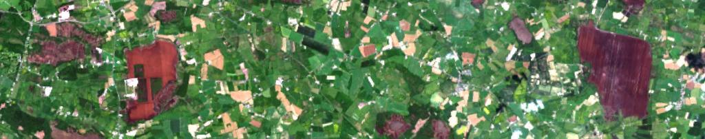
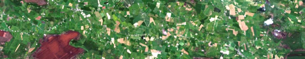
25 National Grasslands Survey Done by hand digitising of regions. Now can do automatically through Image Segmentation

26 LIST of MAIN satellite imaging systems for Irish use in RS of Land Landsat Terra-aster SPOT EROS IKONOS QuickBird Radarsat ENVISAT ERS worldview IRS DMC
27 IRS (Indian Remote Sensing Satellites) IRS P6 (ResourceSat-1) 17/10/2003» Satellite) ALOS 1 24/01/2006» ALOS (Advanced Land Observing BIRD 1 (Bi-Spectral Infrared Detection) BIRD 1 22/10/2001» Jason (Joint Altimetry Satellite Oceanography Network) JASON 07/12/2001» CBERS (China/Brazil Earth Resources Satellite) CBERS-2 (ZY-1B) KOMPSAT (Korea Multi-Purpose Satellite) KOMPSAT 1 20/12/1999» 21/10/2003» KOMPSAT (Korea Multi-Purpose Satellite) KOMPSAT 2 28/07/2006» CloudSat CLOUDSAT 1 28/04/2006» LANDSAT LANDSAT 7 15/04/1999» Digital Globe Constellation WorldView 1 18/09/2007» LANDSAT LANDSAT 5 01/04/1984» Digital Globe Constellation QuickBird 2 18/10/2001» DMC (Disaster Monitoring Constellation) Beijing-1 27/10/2005» METEOR-3 METEOR-3 24/10/1985» DMC (Disaster Monitoring Constellation) UK-DMCSat-1 27/11/2003» MetOp (Operational Meteorological Satellites) MetOp 1 19/10/2006» DMC (Disaster Monitoring Constellation) NigeriaSat-1 27/11/2003» MFG (Meteosat First Generation) Meteosat 6 20/11/1993» DMC (Disaster Monitoring Constellation) BILSAT-1 27/09/2003» MFG (Meteosat First Generation) Meteosat 5 02/03/1991» DMC (Disaster Monitoring Constellation) AlSAT-1 28/11/2002» MFG (Meteosat First Generation) Meteosat 7 03/09/1997» ENVISAT (Environmental Satellite) ENVISAT 01/03/2002» Monitor-E (Monitor Experimental) MONITOR-E 1 26/08/2005 EO-1» (Earth Observing-1) EO-1 21/11/2000» EOS (Earth Observing System) AQUA 04/05/2002» MSG (Meteosat Second Generation) MSG 1 28/08/2002» EOS (Earth Observing System) GRACE 17/03/2002» MSG (Meteosat Second Generation) MSG 2 22/12/2005» EOS (Earth Observing System) TERRA 18/12/1999» MTI (Multispectral Thermal Imager) MTI 12/03/2000» EROS (Earth Remote Observation System) EROS-B 25/04/2006» OrbView OrbView 2 01/08/1997» EROS (Earth Remote Observation System) EROS-A 05/12/2000» ERS (European Remote-Sensing Satellite) ERS-2 21/04/1995» OrbView OrbView 3 26/06/2003» FORMOSAT FORMOSAT 2 21/05/2001» OrbView OrbView 1 01/04/1995» FORMOSAT FORMOSAT 3 16/04/2006» POES (Polar Orbiting Environmental Satellites) NOAA 16 21/09/2000» GOES (Geostationary Operational Environmental Satellite) GOES 12 POES (Polar Orbiting Environmental Satellites) NOAA 17 24/06/2002» 23/07/2001» POES (Polar Orbiting Environmental Satellites) NOAA 18 20/05/2005» Operational Environmental Satellite) GOES 9 GOES (Geostationary 23/05/1995» POES (Polar Orbiting Environmental Satellites) NOAA 14 30/12/1994» GOES (Geostationary POES (Polar Orbiting Environmental Satellites) NOAA 12 14/05/1991» Operational Environmental Satellite) GOES 11 03/05/2000» POES (Polar Orbiting Environmental Satellites) NOAA 15 13/05/1998» GOES (Geostationary Operational Environmental Satellite) GOES 10 PROBA (Project for On-Board Autonomy) PROBA 1 22/10/200125/04/1997»» RadarSat constellation RadarSat 1 04/11/1995» GOES (Geostationary Operational Environmental Satellite) GOES 13 24/05/2006»» Resurs-DK1 (Resurs - High Resolution 1) RESURS DK1 15/06/2006 Ikonos IKONOS-2 24/09/1999» SciSat (Science Satellite) SCISAT 1 13/08/2003» INSAT (Indian National Satellite) INSAT 2E 02/04/1999» SPOT (Système Pour l'observation de la Terre) SPOT 5 04/05/2002» INSAT (Indian National Satellite) INSAT 2C 06/12/1995» SPOT (Système Pour l'observation de la Terre) SPOT 4 24/03/1998 INSAT (Indian»National Satellite) KALPANA 1 12/09/2002» SPOT (Système Pour l'observation de la Terre) SPOT 2 22/01/1990 INSAT (Indian»National Satellite) INSAT 3A 09/04/2003» IRS (Indian Remote Sensing Satellites) IRS 1C 28/12/1995» TOPSAT TOPSAT 1 27/10/2005» IRS (Indian Remote Sensing Satellites) IRS 1D 29/09/1997» TSINGHUA TSINGHUA 1 28/06/2000 IRS (Indian Remote Sensing Satellites) IRS P4 (OceanSat-1) 26/05/1999» IRS (Indian Remote Sensing Satellites) IRS P5 (CartoSat-1) 05/05/2005»
28 Multiple Bands Remember a satellite doesn t just record an image in RED, GREEN and BLUE light. The satellite is able to record information across a wider spectrum and with more discrimination
29 We will use a Landsat8 OLI image with 11 bands
30 B1- Violet: coastal/aerosol band B2: Blue B3: Green B4: Red B5: Near Infra Red NIR- Plant detector B6&7: Short Wave Infra Red- Soil wetness/rock B8: Panchromatic-Higher Res Black and white B9: Cloud Detector B10&11: Thermal Imaging
31 nd-combinations-for-landsat-8/ Natural Color False Color (urban) Color Infrared (vegetation) Agriculture Atmospheric Penetration Healthy Vegetation Land/Water Natural With Atmospheric Removal Shortwave Infrared Vegetation Analysis 6 5 4
32 Practical Using ARC Map today (remember to start the macs in windows) Use Carlow17.tif and sites file (sites.shp) from blog Open Arc Map, load bookmarks and load Base Images. Visit each of the 6 locations and describe what you can see- try to identify the landcover, landuse and habitat
33 Write out your observation using a table like this Site Number Habitat Type Decsription Alternatively, if you are comfortable with ARCMAP you can edit the sites.shp attribute table For Guidance Use Fosset
34 Load Carlow17.tif visit each of the 6 sites- what is the best band combination to distinguish the site form its neighbours. Here's how to load an image and change bands Or here Try this alternate tutorial
35 3/4 One trick you ll have to learn is how to distinguish between dry vegegation and bare soil
36 4/4 Compare the 6 sites Load the Base Map/Image. What can you see at the six sites in the aerial imagery that you can t see in the satellite? Do you need to change any of your 6 habitat observations? What does shaddow tell you for each of the 6 locations
Introduction to Remote Sensing Fundamentals of Satellite Remote Sensing. Mads Olander Rasmussen
 Introduction to Remote Sensing Fundamentals of Satellite Remote Sensing Mads Olander Rasmussen (mora@dhi-gras.com) 01. Introduction to Remote Sensing DHI What is remote sensing? the art, science, and technology
Lecture 6: Multispectral Earth Resource Satellites. The University at Albany Fall 2018 Geography and Planning
 Lecture 6: Multispectral Earth Resource Satellites The University at Albany Fall 2018 Geography and Planning Outline SPOT program and other moderate resolution systems High resolution satellite systems
Interpreting land surface features. SWAC module 3
 Interpreting land surface features SWAC module 3 Interpreting land surface features SWAC module 3 Different kinds of image Panchromatic image True-color image False-color image EMR : NASA Echo the bat
9/12/2011. Training Course Remote Sensing Basic Theory & Image Processing Methods September 2011
 Training Course Remote Sensing Basic Theory & Image Processing Methods 19 23 September 2011 Popular Remote Sensing Sensors & their Selection Michiel Damen (September 2011) damen@itc.nl 1 Overview Low resolution
Image interpretation. Aliens create Indian Head with an ipod? Badlands Guardian (CBC) This feature can be found 300 KMs SE of Calgary.
 This feature can be found 300 KMs SE of Calgary.") Image interpretation Aliens create Indian Head with an ipod? Badlands Guardian (CBC) This feature can be found 300 KMs SE of Calgary. 50 1 N 110 7 W Milestones in the History of Remote Sensing 19 th century
Image interpretation Aliens create Indian Head with an ipod? Badlands Guardian (CBC) This feature can be found 300 KMs SE of Calgary. 50 1 N 110 7 W Milestones in the History of Remote Sensing 19 th century
Introduction to Remote Sensing
 Introduction to Remote Sensing Outline Remote Sensing Defined Resolution Electromagnetic Energy (EMR) Types Interpretation Applications Remote Sensing Defined Remote Sensing is: The art and science of
Final Examination Introduction to Remote Sensing. Time: 1.5 hrs Max. Marks: 50. Section-I (50 x 1 = 50 Marks)
") Final Examination Introduction to Remote Sensing Time: 1.5 hrs Max. Marks: 50 Note: Attempt all questions. Section-I (50 x 1 = 50 Marks) 1... is the technology of acquiring information about the Earth's
Final Examination Introduction to Remote Sensing Time: 1.5 hrs Max. Marks: 50 Note: Attempt all questions. Section-I (50 x 1 = 50 Marks) 1... is the technology of acquiring information about the Earth's
GEOSPATIAL CLOUD COMPUTING SOLUTION APPLIED TO NEW CALEDONIA FOREST MONITORING
 GEOSPATIAL CLOUD COMPUTING SOLUTION APPLIED TO NEW CALEDONIA FOREST MONITORING Worldview-3 30 cm Forgotten Coast New Caledonia DigitalGLobe 2016, Distribution and processing BLUECHAM SAS BLUECHAM SAS 101
NON-PHOTOGRAPHIC SYSTEMS: Multispectral Scanners Medium and coarse resolution sensor comparisons: Landsat, SPOT, AVHRR and MODIS
 NON-PHOTOGRAPHIC SYSTEMS: Multispectral Scanners Medium and coarse resolution sensor comparisons: Landsat, SPOT, AVHRR and MODIS CLASSIFICATION OF NONPHOTOGRAPHIC REMOTE SENSORS PASSIVE ACTIVE DIGITAL
Govt. Engineering College Jhalawar Model Question Paper Subject- Remote Sensing & GIS
 Govt. Engineering College Jhalawar Model Question Paper Subject- Remote Sensing & GIS Time: Max. Marks: Q1. What is remote Sensing? Explain the basic components of a Remote Sensing system. Q2. What is
Satellite Imagery and Remote Sensing. DeeDee Whitaker SW Guilford High EES & Chemistry
 Satellite Imagery and Remote Sensing DeeDee Whitaker SW Guilford High EES & Chemistry whitakd@gcsnc.com Outline What is remote sensing? How does remote sensing work? What role does the electromagnetic
International Charter Space and Major Disasters
 International Charter Space and Major Disasters Sentinel Asia Joint Project Team Meeting July 7, 2010 Brenda Jones U.S. Geological Survey Charter Executive Secretariat Purpose An International agreement
Lecture 13: Remotely Sensed Geospatial Data
 Lecture 13: Remotely Sensed Geospatial Data A. The Electromagnetic Spectrum: The electromagnetic spectrum (Figure 1) indicates the different forms of radiation (or simply stated light) emitted by nature.
Blacksburg, VA July 24 th 30 th, 2010 Remote Sensing Page 1. A condensed overview. For our purposes
 A condensed overview George McLeod Prepared by: With support from: NSF DUE-0903270 in partnership with: Geospatial Technician Education Through Virginia s Community Colleges (GTEVCC) The art and science
REMOTE SENSING INTERPRETATION
 REMOTE SENSING INTERPRETATION Jan Clevers Centre for Geo-Information - WU Remote Sensing --> RS Sensor at a distance EARTH OBSERVATION EM energy Earth RS is a tool; one of the sources of information! 1
CHAPTER 7: Multispectral Remote Sensing
 CHAPTER 7: Multispectral Remote Sensing REFERENCE: Remote Sensing of the Environment John R. Jensen (2007) Second Edition Pearson Prentice Hall Overview of How Digital Remotely Sensed Data are Transformed
ADDITIONAL SATELLITE AND SENSORS
 ADDITIONAL SATELLITE AND SENSORS A list of additional satellites and sensors, along with links to appropriate websites, is presented below. ACRIMSAT (Active Cavity Radiometer Irradiance Monitor Satellite)
Introduction to Remote Sensing
 Introduction to Remote Sensing Daniel McInerney Urban Institute Ireland, University College Dublin, Richview Campus, Clonskeagh Drive, Dublin 14. 16th June 2009 Presentation Outline 1 2 Spaceborne Sensors
Earth s Gravitational Pull
 Satellite & Sensors Space Countries Earth s Gravitational Pull The Earth's gravity pulls everything toward the Earth. In order to orbit the Earth, the velocity of a body must be great enough to overcome
Remote Sensing Platforms
 Remote Sensing Platforms Remote Sensing Platforms - Introduction Allow observer and/or sensor to be above the target/phenomena of interest Two primary categories Aircraft Spacecraft Each type offers different
CHAPTER 5. Image Interpretation
 CHAPTER 5 Image Interpretation Introduction To translate images into information, we must apply a specialized knowlage, image interpretation, which we can apply to derive useful information from the raw
Remote Sensing Platforms
 Types of Platforms Lighter-than-air Remote Sensing Platforms Free floating balloons Restricted by atmospheric conditions Used to acquire meteorological/atmospheric data Blimps/dirigibles Major role - news
Important Missions. weather forecasting and monitoring communication navigation military earth resource observation LANDSAT SEASAT SPOT IRS
 Fundamentals of Remote Sensing Pranjit Kr. Sarma, Ph.D. Assistant Professor Department of Geography Mangaldai College Email: prangis@gmail.com Ph. No +91 94357 04398 Remote Sensing Remote sensing is defined
An Introduction to Geomatics. Prepared by: Dr. Maher A. El-Hallaq خاص بطلبة مساق مقدمة في علم. Associate Professor of Surveying IUG
 An Introduction to Geomatics خاص بطلبة مساق مقدمة في علم الجيوماتكس Prepared by: Dr. Maher A. El-Hallaq Associate Professor of Surveying IUG 1 Airborne Imagery Dr. Maher A. El-Hallaq Associate Professor
Atmospheric Correction (including ATCOR)
") Technical Specifications Atmospheric Correction (including ATCOR) The data obtained by optical satellite sensors with high spatial resolution has become an invaluable tool for many groups interested in
Technical Specifications Atmospheric Correction (including ATCOR) The data obtained by optical satellite sensors with high spatial resolution has become an invaluable tool for many groups interested in
Introduction to Remote Sensing
 Introduction to Remote Sensing Spatial, spectral, temporal resolutions Image display alternatives Vegetation Indices Image classifications Image change detections Accuracy assessment Satellites & Air-Photos
Sensors and Data Interpretation II. Michael Horswell
 Sensors and Data Interpretation II Michael Horswell Defining remote sensing 1. When was the last time you did any remote sensing? acquiring information about something without direct contact 2. What are
1. Theory of remote sensing and spectrum
 1. Theory of remote sensing and spectrum 7 August 2014 ONUMA Takumi Outline of Presentation Electromagnetic wave and wavelength Sensor type Spectrum Spatial resolution Spectral resolution Mineral mapping
CHARACTERISTICS OF REMOTELY SENSED IMAGERY. Spatial Resolution
 CHARACTERISTICS OF REMOTELY SENSED IMAGERY Spatial Resolution There are a number of ways in which images can differ. One set of important differences relate to the various resolutions that images express.
Image interpretation I and II
 Image interpretation I and II Looking at satellite image, identifying different objects, according to scale and associated information and to communicate this information to others is what we call as IMAGE
Int n r t o r d o u d c u ti t on o n to t o Remote Sensing
 Introduction to Remote Sensing Definition of Remote Sensing Remote sensing refers to the activities of recording/observing/perceiving(sensing)objects or events at far away (remote) places. In remote sensing,
9/12/2011. Training Course Remote Sensing Basic Theory & Image Processing Methods September 2011
 Training Course Remote Sensing Basic Theory & Image Processing Methods 19 23 September 2011 Introduction to Remote Sensing Michiel Damen (September 2011) damen@itc.nl 1 Overview Some definitions Remote
Remote Sensing 1 Principles of visible and radar remote sensing & sensors
 Remote Sensing 1 Principles of visible and radar remote sensing & sensors Nick Barrand School of Geography, Earth & Environmental Sciences University of Birmingham, UK Field glaciologist collecting data
Remote Sensing for Rangeland Applications
 Remote Sensing for Rangeland Applications Jay Angerer Ecological Training June 16, 2012 Remote Sensing The term "remote sensing," first used in the United States in the 1950s by Ms. Evelyn Pruitt of the
746A27 Remote Sensing and GIS
 746A27 Remote Sensing and GIS Lecture 1 Concepts of remote sensing and Basic principle of Photogrammetry Chandan Roy Guest Lecturer Department of Computer and Information Science Linköping University What
NRS 415 Remote Sensing of Environment
 NRS 415 Remote Sensing of Environment 1 High Oblique Perspective (Side) Low Oblique Perspective (Relief) 2 Aerial Perspective (See What s Hidden) An example of high spatial resolution true color remote
The (False) Color World
 Color World") There s more to the world than meets the eye In this activity, your group will explore: The Value of False Color Images Different Types of Color Images The Use of Contextual Clues for Feature Identification
There s more to the world than meets the eye In this activity, your group will explore: The Value of False Color Images Different Types of Color Images The Use of Contextual Clues for Feature Identification
GIS Data Collection. Remote Sensing
 GIS Data Collection Remote Sensing Data Collection Remote sensing Introduction Concepts Spectral signatures Resolutions: spectral, spatial, temporal Digital image processing (classification) Other systems
A map says to you, 'Read me carefully, follow me closely, doubt me not.' It says, 'I am the Earth in the palm of your hand. Without me, you are alone
 A map says to you, 'Read me carefully, follow me closely, doubt me not.' It says, 'I am the Earth in the palm of your hand. Without me, you are alone and lost. Beryl Markham (West With the Night, 1946
Topographic mapping from space K. Jacobsen*, G. Büyüksalih**
 Topographic mapping from space K. Jacobsen*, G. Büyüksalih** * Institute of Photogrammetry and Geoinformation, Leibniz University Hannover ** BIMTAS, Altunizade-Istanbul, Turkey KEYWORDS: WorldView-1,
746A27 Remote Sensing and GIS. Multi spectral, thermal and hyper spectral sensing and usage
 746A27 Remote Sensing and GIS Lecture 3 Multi spectral, thermal and hyper spectral sensing and usage Chandan Roy Guest Lecturer Department of Computer and Information Science Linköping University Multi
Remote sensing in archaeology from optical to lidar. Krištof Oštir ModeLTER Scientific Research Centre of the Slovenian Academy of Sciences and Arts
 Remote sensing in archaeology from optical to lidar Krištof Oštir ModeLTER Scientific Research Centre of the Slovenian Academy of Sciences and Arts Introduction Optical remote sensing Systems Search for
Environmental and Natural Resources Issues in Minnesota. A Remote Sensing Overview: Principles and Fundamentals. Outline. Challenges.
 A Remote Sensing Overview: Principles and Fundamentals Marvin Bauer Remote Sensing and Geospatial Analysis Laboratory College of Natural Resources University of Minnesota Remote Sensing for GIS Users Workshop,
High Resolution Imaging Satellite Systems
 High Resolution Imaging Satellite Systems K. Jacobsen University of Hannover, Germany Keywords: high resolution space sensors, SAR ABSTRACT: The number of existing and announced high and very high resolution
Geo/SAT 2 INTRODUCTION TO REMOTE SENSING
 Geo/SAT 2 INTRODUCTION TO REMOTE SENSING Paul R. Baumann, Professor Emeritus State University of New York College at Oneonta Oneonta, New York 13820 USA COPYRIGHT 2008 Paul R. Baumann Introduction Remote
Overview of the Small Optical TrAnsponder (SOTA) Project
 Project") Overview of the Small Optical TrAnsponder (SOTA) Project Space Communications Laboratory Wireless Networks Research Center National Institute of Information and Communications Technology (NICT) Satellite
Overview of the Small Optical TrAnsponder (SOTA) Project Space Communications Laboratory Wireless Networks Research Center National Institute of Information and Communications Technology (NICT) Satellite
Remote Sensing. Measuring an object from a distance. For GIS, that means using photographic or satellite images to gather spatial data
 Remote Sensing Measuring an object from a distance For GIS, that means using photographic or satellite images to gather spatial data Remote Sensing measures electromagnetic energy reflected or emitted
UNOSAT Satellite Imagery and GIS Solutions for DRR and Emergency Management
 UNOSAT Satellite Imagery and GIS Solutions for DRR and Emergency Management Francesco Pisano Director, Research, Technology Applications & Knowledge Systems January 2013 Introduction to UNOSAT 2 About
Sommersemester Prof. Dr. Christoph Kleinn Institut für Waldinventur und Waldwachstum Arbeitsbereich Fernerkundung und Waldinventur.
 Basics of Remote Sensing Some literature references Franklin, SE 2001 Remote Sensing for Sustainable Forest Management Lewis Publishers 407p Lillesand, Kiefer 2000 Remote Sensing and Image Interpretation
REMOTE SENSING. Topic 10 Fundamentals of Digital Multispectral Remote Sensing MULTISPECTRAL SCANNERS MULTISPECTRAL SCANNERS
 REMOTE SENSING Topic 10 Fundamentals of Digital Multispectral Remote Sensing Chapter 5: Lillesand and Keifer Chapter 6: Avery and Berlin MULTISPECTRAL SCANNERS Record EMR in a number of discrete portions
EE 529 Remote Sensing Techniques. Introduction
 EE 529 Remote Sensing Techniques Introduction Course Contents Radar Imaging Sensors Imaging Sensors Imaging Algorithms Imaging Algorithms Course Contents (Cont( Cont d) Simulated Raw Data y r Processing
Ten years of remote sensing advancement & the research outcome of the CRC-AGIP Lab
 Ten years of remote sensing advancement & the research outcome of the CRC-AGIP Lab Dr. Yun Zhang Canada Research Chair Laboratory in Advanced Geomatics Image Processing (CRC-AGIP Lab) Department of Geodesy
Satellite Remote Sensing: Earth System Observations
 Satellite Remote Sensing: Earth System Observations Land surface Water Atmosphere Climate Ecosystems 1 EOS (Earth Observing System) Develop an understanding of the total Earth system, and the effects of
Outline Remote Sensing Defined Resolution Electromagnetic Energy (EMR) Types Interpretation Applications 2
 Types Interpretation Applications 2") Introduction to Remote Sensing 1 Outline Remote Sensing Defined Resolution Electromagnetic Energy (EMR) Types Interpretation Applications 2 Remote Sensing Defined Remote Sensing is: The art and science
Introduction to Remote Sensing 1 Outline Remote Sensing Defined Resolution Electromagnetic Energy (EMR) Types Interpretation Applications 2 Remote Sensing Defined Remote Sensing is: The art and science
An Introduction to Remote Sensing & GIS. Introduction
 An Introduction to Remote Sensing & GIS Introduction Remote sensing is the measurement of object properties on Earth s surface using data acquired from aircraft and satellites. It attempts to measure something
remote sensing? What are the remote sensing principles behind these Definition
 Introduction to remote sensing: Content (1/2) Definition: photogrammetry and remote sensing (PRS) Radiation sources: solar radiation (passive optical RS) earth emission (passive microwave or thermal infrared
Outline Remote Sensing Defined Resolution Electromagnetic Energy (EMR) Types Interpretation Applications
 Types Interpretation Applications") Introduction to Remote Sensing Outline Remote Sensing Defined Resolution Electromagnetic Energy (EMR) Types Interpretation Applications Remote Sensing Defined Remote Sensing is: The art and science of
Introduction to Remote Sensing Outline Remote Sensing Defined Resolution Electromagnetic Energy (EMR) Types Interpretation Applications Remote Sensing Defined Remote Sensing is: The art and science of
CALL359 JAPAN S EARTHQUAKE 2011, MARCH, 11
 CALL359 JAPAN S EARTHQUAKE 2011, MARCH, 11 PM for International Charter Dr. Masahiko Nagai JAXA - AIT 25th Meeting of the International Charter May 12 th 2011 on 2011, March, 11 at 14:46 (JST) Iwate Pref.
earthobservation.wordpress.com
 Dirty REMOTE SENSING earthobservation.wordpress.com Stuart Green Teagasc Stuart.Green@Teagasc.ie 1 Purpose Give you a very basic skill set and software training so you can: find free satellite image data.
Dirty REMOTE SENSING Lecture 3: First Steps in classifying Stuart Green Earthobservation.wordpress.com
 Dirty REMOTE SENSING Lecture 3: First Steps in classifying Stuart Green Earthobservation.wordpress.com Stuart.Green@Teagasc.ie You have your image, but is it any good? Is it full of cloud? Is it the right
ROLE OF SATELLITE DATA APPLICATION IN CADASTRAL MAP AND DIGITIZATION OF LAND RECORDS DR.T. RAVISANKAR GROUP HEAD (LRUMG) RSAA/NRSC/ISRO /DOS HYDERABAD
 RSAA/NRSC/ISRO /DOS HYDERABAD") ROLE OF SATELLITE DATA APPLICATION IN CADASTRAL MAP AND DIGITIZATION OF LAND RECORDS DR.T. RAVISANKAR GROUP HEAD (LRUMG) RSAA/NRSC/ISRO /DOS HYDERABAD WORKSHOP on Best Practices under National Land Records
ROLE OF SATELLITE DATA APPLICATION IN CADASTRAL MAP AND DIGITIZATION OF LAND RECORDS DR.T. RAVISANKAR GROUP HEAD (LRUMG) RSAA/NRSC/ISRO /DOS HYDERABAD WORKSHOP on Best Practices under National Land Records
Introduction of Satellite Remote Sensing
 Introduction of Satellite Remote Sensing Spatial Resolution (Pixel size) Spectral Resolution (Bands) Resolutions of Remote Sensing 1. Spatial (what area and how detailed) 2. Spectral (what colors bands)
ACTIVE SENSORS RADAR
 ACTIVE SENSORS RADAR RADAR LiDAR: Light Detection And Ranging RADAR: RAdio Detection And Ranging SONAR: SOund Navigation And Ranging Used to image the ocean floor (produce bathymetic maps) and detect objects
Copernicus Introduction Lisbon, Portugal 13 th & 14 th February 2014
 Copernicus Introduction Lisbon, Portugal 13 th & 14 th February 2014 Contents Introduction GMES Copernicus Six thematic areas Infrastructure Space data An introduction to Remote Sensing In-situ data Applications
Supported Satellite Optical Sensors
 Geomatica 2017 Sensor List This document contains detailed information about format support provided in Geomatica for satellite optical, radar and aerial sensors. Supported Satellite Optical Sensors Valid
Background Objectives Study area Methods. Conclusions and Future Work Acknowledgements
 A DIGITAL PROCESSING AND DATA COMPILATION APPROACH FOR USING REMOTELY SENSED IMAGERY TO IDENTIFY GEOLOGICAL LINEAMENTS IN HARD-ROCK ROCK TERRAINS: AN APPLICATION FOR GROUNDWATER EXPLORATION IN NICARAGUA
Visualizing a Pixel. Simulate a Sensor s View from Space. In this activity, you will:
 Simulate a Sensor s View from Space In this activity, you will: Measure and mark pixel boundaries Learn about spatial resolution, pixels, and satellite imagery Classify land cover types Gain exposure to
Remote Sensing in Daily Life. What Is Remote Sensing?
 Remote Sensing in Daily Life What Is Remote Sensing? First time term Remote Sensing was used by Ms Evelyn L Pruitt, a geographer of US in mid 1950s. Minimal definition (not very useful): remote sensing
Dr. P Shanmugam. Associate Professor Department of Ocean Engineering Indian Institute of Technology (IIT) Madras INDIA
 Madras INDIA") Dr. P Shanmugam Associate Professor Department of Ocean Engineering Indian Institute of Technology (IIT) Madras INDIA Biography Ph.D (Remote Sensing and Image Processing for Coastal Studies) - Anna University,
Dr. P Shanmugam Associate Professor Department of Ocean Engineering Indian Institute of Technology (IIT) Madras INDIA Biography Ph.D (Remote Sensing and Image Processing for Coastal Studies) - Anna University,
Application of Satellite Remote Sensing for Natural Disasters Observation
 Application of Satellite Remote Sensing for Natural Disasters Observation Prof. Krištof Oštir, Ph.D. University of Ljubljana Faculty of Civil and Geodetic Engineering Outline Earth observation current
APCAS/10/21 April 2010 ASIA AND PACIFIC COMMISSION ON AGRICULTURAL STATISTICS TWENTY-THIRD SESSION. Siem Reap, Cambodia, April 2010
 APCAS/10/21 April 2010 Agenda Item 8 ASIA AND PACIFIC COMMISSION ON AGRICULTURAL STATISTICS TWENTY-THIRD SESSION Siem Reap, Cambodia, 26-30 April 2010 The Use of Remote Sensing for Area Estimation by Robert
Satellite Imagery Characteristics, Uses and Delivery to GIS Systems. Wayne Middleton April 2014
 Satellite Imagery Characteristics, Uses and Delivery to GIS Systems Wayne Middleton April 2014 About Geoimage Founded in Brisbane 1988 Leading Independent company Specialists in satellite imagery and geospatial
Aerial Photo Interpretation
 Aerial Photo Interpretation Aerial Photo Interpretation To date, course has focused on skills of photogrammetry Scale Distance Direction Area Height There s another side to Aerial Photography: Interpretation
Remote Sensing of Environment (RSE)
") I N T R O Introduction to Introduction to Remote Sensing T O R S E Remote Sensing of Environment (RSE) with TNTmips page 1 TNTview Before Getting Started Imagery acquired by airborne or satellite sensors
I N T R O Introduction to Introduction to Remote Sensing T O R S E Remote Sensing of Environment (RSE) with TNTmips page 1 TNTview Before Getting Started Imagery acquired by airborne or satellite sensors
Introduction to Remote Sensing
 Introduction to Remote Sensing 1 Outline Remote Sensing Defined Electromagnetic Energy (EMR) Resolution Interpretation 2 Remote Sensing Defined Remote Sensing is: The art and science of obtaining information
CHARACTERISTICS OF REMOTELY SENSED IMAGERY. Radiometric Resolution
 CHARACTERISTICS OF REMOTELY SENSED IMAGERY Radiometric Resolution There are a number of ways in which images can differ. One set of important differences relate to the various resolutions that images express.
Introduction. Introduction. Introduction. Introduction. Introduction
 Identifying habitat change and conservation threats with satellite imagery Extinction crisis Volker Radeloff Department of Forest Ecology and Management Extinction crisis Extinction crisis Conservationists
to Geospatial Technologies
 What s in a Pixel? A Primer for Remote Sensing What s in a Pixel Development UNH Cooperative Extension Geospatial Technologies Training Center Shane Bradt UConn Cooperative Extension Geospatial Technology
ENVI Orthorectification Module
 ENVI Orthorectification Module Orthorectify your imagery quickly and easily. CREASO - your partner for visual information solutions Rigorous Orthorectification. Simple Workflow. Trusted Method. The Need
Lecture Series SGL 308: Introduction to Geological Mapping Lecture 8 LECTURE 8 REMOTE SENSING METHODS: THE USE AND INTERPRETATION OF SATELLITE IMAGES
 LECTURE 8 REMOTE SENSING METHODS: THE USE AND INTERPRETATION OF SATELLITE IMAGES LECTURE OUTLINE Page 8.0 Introduction 114 8.1 Objectives 115 115 8.2 Remote Sensing: Method of Operation 8.3 Importance
IKONOS High Resolution Multispectral Scanner Sensor Characteristics
 High Spatial Resolution and Hyperspectral Scanners IKONOS High Resolution Multispectral Scanner Sensor Characteristics Launch Date View Angle Orbit 24 September 1999 Vandenberg Air Force Base, California,
Trend of Small EO Satellites and Their Applications
 UN Symposium to Strengthen the Partnership with Industry Nurturing the Development of Space Technology Trend of Small EO Satellites and Their Applications For further information, Phone: +82 42 365 7506
HYPERSPECTRAL IMAGERY FOR SAFEGUARDS APPLICATIONS. International Atomic Energy Agency, Vienna, Austria
 HYPERSPECTRAL IMAGERY FOR SAFEGUARDS APPLICATIONS G. A. Borstad 1, Leslie N. Brown 1, Q.S. Bob Truong 2, R. Kelley, 3 G. Healey, 3 J.-P. Paquette, 3 K. Staenz 4, and R. Neville 4 1 Borstad Associates Ltd.,
REMOTE SENSING FOR FLOOD HAZARD STUDIES.
 REMOTE SENSING FOR FLOOD HAZARD STUDIES. OPTICAL SENSORS. 1 DRS. NANETTE C. KINGMA 1 Optical Remote Sensing for flood hazard studies. 2 2 Floods & use of remote sensing. Floods often leaves its imprint
FOR 474: Forest Inventory. FOR 474: Forest Inventory. Why do we Care About Forest Sampling?
 FOR 474: Forest Inventory 1. Advanced Forest Inventory The Need for Forest Sampling Brief Intro to Remote Sensing and GIS Readings: FOR 474: Forest Inventory Related Courses! FOR 274: Forest Measurements
ENVI Orthorectification Module
 Visual Information Solutions ENVI Orthorectification Module Orthorectify Your Imagery Quickly and Easily. Rigorous Orthorectification. Simple Workflow. Trusted Method. The Need for Orthorectification Satellite
Role of Landsat in Revolutionizing the Management of Natural Resources. Prof. UR Rao Former Chairman, ISRO, India
 Role of Landsat in Revolutionizing the Management of Natural Resources Prof. UR Rao Former Chairman, ISRO, India 40 Years of Landsat, June 6, 2012 Evolution of Remote Sensing Satellites TIROS Aerial Survey
Tutorial 10 Information extraction from high resolution optical satellite sensors
 Tutorial 10 Information extraction from high resolution optical satellite sensors Karsten Jacobsen 1, Emmanuel Baltsavias 2, David Holland 3 1 University of, ienburger Strasse 1, D-30167, Germany, jacobsen@ipi.uni-hannover.de
Overview. Introduction. Elements of Image Interpretation. LA502 Special Studies Remote Sensing
 LA502 Special Studies Remote Sensing Elements of Image Interpretation Dr. Ragab Khalil Department of Landscape Architecture Faculty of Environmental Design King AbdulAziz University Room 103 Overview Introduction
Using QuickBird Imagery in ESRI Software Products
 Using QuickBird Imagery in ESRI Software Products TABLE OF CONTENTS 1. Introduction...2 Purpose Scope Image Stretching Color Guns 2. Imagery Usage Instructions...4 ArcView 3.x...4 ArcGIS...7 i Using QuickBird
EO Data Today and Application Fields. Denise Petala
 EO Data Today and Application Fields Denise Petala ! IGD GROUP AE "Infotop SA, Geomet Ltd., Dynatools Ltd. "Equipment and know how in many application fields, from surveying till EO data and RS. # Leica,
What we can see from space; and how to link it to data and statistics
 What we can see from space; and how to link it to data and statistics Mohammed Said 1, Shem Kifugo 1, Madelene Ostwald 2, Gert Nyberg 3, and Lance Robinson 1 1 International Livestock Research Institute,
FOR 353: Air Photo Interpretation and Photogrammetry. Lecture 2. Electromagnetic Energy/Camera and Film characteristics
 FOR 353: Air Photo Interpretation and Photogrammetry Lecture 2 Electromagnetic Energy/Camera and Film characteristics Lecture Outline Electromagnetic Radiation Theory Digital vs. Analog (i.e. film ) Systems
366 Glossary. Popular method for scale drawings in a computer similar to GIS but without the necessity for spatial referencing CEP
 366 Glossary GISci Glossary ASCII ASTER American Standard Code for Information Interchange Advanced Spaceborne Thermal Emission and Reflection Radiometer Computer Aided Design Circular Error Probability
Microwave Remote Sensing (1)
") Microwave Remote Sensing (1) Microwave sensing encompasses both active and passive forms of remote sensing. The microwave portion of the spectrum covers the range from approximately 1cm to 1m in wavelength.
Microwave Remote Sensing (1) Microwave sensing encompasses both active and passive forms of remote sensing. The microwave portion of the spectrum covers the range from approximately 1cm to 1m in wavelength.
INTRODUCTORY REMOTE SENSING. Geob 373
 INTRODUCTORY REMOTE SENSING Geob 373 Landsat 7 15 m image highlighting the geology of Oman http://www.satimagingcorp.com/gallery-landsat.html ASTER 15 m SWIR image, Escondida Mine, Chile http://www.satimagingcorp.com/satellite-sensors/aster.html
COMPARISON OF INFORMATION CONTENTS OF HIGH RESOLUTION SPACE IMAGES
 COMPARISON OF INFORMATION CONTENTS OF HIGH RESOLUTION SPACE IMAGES H. Topan*, G. Büyüksalih*, K. Jacobsen ** * Karaelmas University Zonguldak, Turkey ** University of Hannover, Germany htopan@karaelmas.edu.tr,
Module 3 Introduction to GIS. Lecture 8 GIS data acquisition
 Module 3 Introduction to GIS Lecture 8 GIS data acquisition GIS workflow Data acquisition (geospatial data input) GPS Remote sensing (satellites, UAV s) LiDAR Digitized maps Attribute Data Management Data
MSB Imagery Program FAQ v1
 MSB Imagery Program FAQ v1 (F)requently (A)sked (Q)uestions 9/22/2016 This document is intended to answer commonly asked questions related to the MSB Recurring Aerial Imagery Program. Table of Contents
CHARACTERISTICS OF VERY HIGH RESOLUTION OPTICAL SATELLITES FOR TOPOGRAPHIC MAPPING
 CHARACTERISTICS OF VERY HIGH RESOLUTION OPTICAL SATELLITES FOR TOPOGRAPHIC MAPPING K. Jacobsen Leibniz University Hannover, Institute of Photogrammetry and Geoinformation jacobsen@ipi.uni-hannover.de Commission