SHRP2 R15B Identifying and Managing Utility Conflicts
|
|
|
- Bruno Morrison
- 5 years ago
- Views:
Transcription


1 SHRP2 R15B Identifying and Managing Utility Conflicts SHRP2 Peer Exchange Webinar February 5, 2019
2 Welcome and Agenda Introduction and Opening Remarks Overview and Status of R15B Product IAP State Challenges and Strategies Updates from IAP States Use of Bentley SUE/SUDA at State DOTs SUE/SUDA Implementation Strategies Presentation by Bentley Systems SUE/SUDA at TXDOT Presentation by TXDOT Implementation of SUE/SUDA at Utah DOT Presentation by Utah DOT 2
3 Agenda 5 minutes Introductions & Opening Remarks Introductions Objective of Call Opening Remarks 10 minutes Overview and Status of R15B Product Implementation closeout/end of technical support Update on technical assistance activities by FHWA/AASHTO/SME 30 mins IAP State Challenges and Strategies Update from all IAP States, with a focus on the following: Leadership buy-in IT support Logistical challenges Plan for upcoming months 45 minutes Use of Bentley SUE/SUDA at State DOTs Presentation by Bentley Systems SUE/SUDA Implementation Strategies Presentation by TxDOT Use of SUE/SUDA at TxDOT Presentation by Utah DOT Implementation of SUE/SUDA at Utah DOT Adjourn All Ross Gray AASHTO/FHWA FHWA Cesar Quiroga Cesar Quiroga IAP States: California, Delaware, Iowa, Kentucky, Maryland, Michigan, Montana, Oklahoma, Oregon, Pennsylvania, South Carolina, South Dakota, Texas, Utah, Vermont, Washington Sonya Pieterse Ab Maamar-Tayeb Bob Peterson 3
4 Overview and Status of R15B Product Implementation closeout/end of technical support (Julie Johnson) Update on technical assistance activities by FHWA/AASHTO/SME (Cesar Quiroga) 4
5 IAP State Challenges and Strategies California Delaware Iowa Kentucky Maryland Michigan Montana Oklahoma Oregon Pennsylvania South Carolina South Dakota Texas Utah Vermont Washington 5
6 Subsurface Utilities Sonya Pieterse, Senior Application Engineer Bentley Systems Inc Bentley Systems, Incorporated Bentley Systems, Incorporated
7 Agenda OpenRoads Designer and Subsurface Utilities Licensing Subsurface Utility Capabilities Importing from other data Clash Detection Constructability Subsurface Utility Configuration: Cells, Element Templates, and Hydraulic Properties How to get setup options Please make a note of your questions and we will do our best to answer them after Bob Peterson s presentation Bentley Systems, Incorporated
8 DRAWING PRODUCTION DRAWING PRODUCTION DRAWING PRODUCTION 3D MODELING 3D MODELING 3D MODELING Bentley Systems, Incorporated


9 OpenRoads 3D Modeling Subsurface Utility Engineering Descartes StormCAD Bentley Systems, Incorporated

10 OpenRoads Designer 3D Roadway Design Subsurface Utility Engineering Descartes InRoads GEOPAK MX StormCAD Bentley Systems, Incorporated
11 OpenRoads Designer 3D Roadway Design Subsurface Utility Engineering Descartes InRoads GEOPAK MX StormCAD Bentley Systems, Incorporated
12 OpenRoads Designer 3D Roadway Design Descartes InRoads GEOPAK MX StormCAD Subsurface Utility Engineering Bentley Systems, Incorporated

13 OpenRoads Designer 3D Roadway Design InRoads GEOPAK StormCAD MX Descartes Subsurface Utility Engineering Bentley Systems, Incorporated
 Any point or linear utility that needs to be modeled It s part of OpenRoads Designer Encompasses the OpenFlows products StormCAD/CivilStorm/SewerCAD/SewerGEMS 14 WWW.BENTLEY.")
14 Subsurface Utilities Subsurface Utilities is the nom du jour You may see it abbreviated as SU Replaces the name Subsurface Utilities Design and Analysis (SUDA) And Subsurface Utility Engineering (SUE) Any point or linear utility that needs to be modeled It s part of OpenRoads Designer Encompasses the OpenFlows products StormCAD/CivilStorm/SewerCAD/SewerGEMS Bentley Systems, Incorporated
15 Subsurface Licensing If you own this license: Drainage Functions Utility Functions Any OpenRoads Technology (SS4): GEOPAK PowerGEOPAK InRoads PowerInRoads MX Any of the OpenRoads technology in SS4 above plus a SUE license. StormCAD which includes storm water design and analysis. Maximum of 100 inlets per drainage model. Storm water attributes. Same hydraulic calculation capabilities as above. Utilities can be modeled in 3D. Utilities can be modeled in 3D. Unique Utility Attributes. Utility conflict tools/clash Detection OpenRoads Designer CONNECT Edition StormCAD which includes storm water design and analysis. Maximum of 100 inlets per drainage model. Storm water attributes. OpenRoads Designer CONNECT Edition plus the following additional licenses: StormCAD Unlimited SewerCAD CivilStorm SewerGEMS Additional hydraulic calculations depending on which license is activated. Utilities can be modeled in 3D. Unique Utility Attributes. Utility conflict tools/clash Detection Utilities can be modeled in 3D. Unique Utility Attributes. Utility conflict tools/clash Detection Bentley Systems, Incorporated

16 Subsurface Product Activation To activate an additional product go to Subsurface Utilities > Tools > License Activation. If activated, an alert that an additional license usage will be logged which may result in incremental cost Bentley Systems, Incorporated

17 OpenRoads Designer CONNECT Edition Environment Bentley Systems, Incorporated


18 Subsurface Utility Capabilities Based on OpenRoads Modelling 3D modeling of all underground assets, existing or proposed. Hydraulic Design of Storm and Sanitary Utilities. Advanced Conflict Detection / Conflict Management Bentley Systems, Incorporated

19 Creating the model Bentley Systems, Incorporated


20 All Utilities can be modeled Bentley Systems, Incorporated

21 Extracting from Existing Graphics Subsurface Utilities > Layout > Extract from Graphics The Extract Utilities from Graphics tool provides the ability to create 3D drainage elements from graphic elements. These elements may result from survey processes, GIS graphic data, OpenRoads Geometry or other sources. But, in every case the elements are DGN graphic elements Bentley Systems, Incorporated


22 Utility Filter Created in the dgnlib. Extracts Graphics based on stored search parameters Bentley Systems, Incorporated

23 Importing from other Data Sources Subsurface Utilities > Home > Model Import/Export > Import Utilities Haestad LandXML MicroDrainage InRoads S&S The following products using SHP files: StormCAD CivilStorm SewerCAD SewerGEMS WaterGEMS WaterCAD Bentley Systems, Incorporated


24 Model Builder Connects to any data source, including: SHP XLS TXT, CSV Oracle Spatial Geospatial sources are preferred. Creates 2 way link for import, export and update Bentley Systems, Incorporated

25 Clash Detection Subsurface Utilities > Tools > Clash Detection Requires the SUE License in SS Bentley Systems, Incorporated


26 Detecting and Managing Utility Conflicts Training available on Learn Server. 1. Select Feature or Level to check 2. Select Feature or Level to check against 3. Review Flex Table Bentley Systems, Incorporated


27 Bentley Systems, Incorporated Setting up a Workspace to include Subsurface Cells, Element Templates, Feature Symbologies & Feature Definitions
28 Workflow: Creating Subsurface Nodes 1. Have Linestyles, Levels, and Materials created. 2. Create 2D plan cells for Plan View of structures. 3. Create 3D top cells for the 3D top portion of the structures. 4. Create 3D bottom cells for the 3D bottom portion of the structures. 5. Create Elements Templates for: Plan Points to level for the structure and the 2D cell. Profile Points to level for the profile of the structure. 3D Top Points to level for the structure and the 3D top cell. 3D Bottom Points to level for the structure and the 3D bottom cell. 6. Create Feature Symbologies 7. Create Feature Definitions Bentley Systems, Incorporated

29 The Parts of a Subsurface Element Feature Definition the container which holds all the other parts and defines function. Feature Symbology points to element templates for symbology information. Element Templates defines the symbology, material, and cells to be used. Cell Library: 2D cells are used for plan view presentation. 3D cell for modeling the top and bottom of the utility structures. Can be stored in one or multiple files. Levels, Cells, & Materials Element Templates Feature Symbologies Feature Definitions Bentley Systems, Incorporated

30 What is a Feature Definition Feature Definitions link to Feature Symbolgies which link to MicroStation element templates, that define the symbology in the various view spaces: Plan Profile and 3D OpenRoads: It starts with the Feature Definition Bentley Systems, Incorporated
31 Subsurface Feature Definitions Types of Subsurface Features: Nodes Structures (inlets, manholes, headwalls, etc.) Conduit Pipes (elliptical, circular, box, arch, etc.) Catchments Drainage Areas Bentley Systems, Incorporated


32 Node Feature Symbology Feature Symbolgies: Point Plan Profile Solid 3D Element Defines the symbology for all 4 views. Links to MicroStation Element Templates. Feature Symbologies for subsurface nodes typically require 2 3D templates (Top and Bottom). Point Profile Solid Bentley Systems, Incorporated

33 Node Feature Symbology Bentley Systems, Incorporated


34 Creating Element Templates Element Templates define symbology, cells, and materials to be used for feature symbologies. One Element Template can be used in multiple features. Define Element Templates in dgn library file (.dgnlib). Separate Element Templates for: Plan Profile 3D Top 3D Bottom Bentley Systems, Incorporated

35 Subsurface Node Creation When a Subsurface node is placed, the 3D top and bottom cells are merged. Including an extrusion in middle to vary the height. Extrusion Config Variables: SU_3D_Structure_ExtrudeMethod = UP SU_3D_Structure_ExtrudeMethod = DOWN Bentley Systems, Incorporated


36 Water Feature Definitions and Hydraulic Properties For storm or waste water utility types, you define the hydraulic characteristics by linking to a hydraulic prototype. The Conduit sizes are defined in the Conduit Catalog. Subsurface Utilities Workflow > Components Tab > Catalog or Prototype Bentley Systems, Incorporated
37 Subsurface Configuration Variables Node and Conduit Feature definition libraries: CIVIL_CONTENTMANAGEMENTDGNLIBLIST > $(_USTN_PROJECTDATA)/dgnlib/Sample Drainage FeatureDefs*.dgnlib CIVIL_CONTENTMANAGEMENTDGNLIBLIST > $(_USTN_PROJECTDATA)/dgnlib/*Conduit Library.dgnlib The utility libraries also contains the levels, element templates and additional line styles needed for utilities: MS_DGNLIBLIST > $(_USTN_PROJECTDATA)/dgnlib/Sample Drainage FeatureDefs*.dgnlib MS_DGNLIBLIST > $(_USTN_PROJECTDATA)/dgnlib/*Conduit Library.dgnlib Utility and Drainage cell libraries are loaded with the workspace Bentley Systems, Incorporated
 Can be changed in the design file. This is just a starting point.")
38 Project Defaults Should be created and stored in the dgnlib. Stores the following parameters Hydraulic Model Preferences Default drawing scale Units ProjectWise (Optional) Can be changed in the design file. This is just a starting point. Subsurface Utilities Workflow > Tools Tab > Project Defaults Bentley Systems, Incorporated

39 Default Design Constraints Stored in the dgnlib. Sets default constraints for Gravity Pipes, Nodes, and Inlets. Subsurface Utilities Workflow > Analysis Tab > Default Design Constraints Bentley Systems, Incorporated

40 Storm Data Subsurface Utilities > Components > Storm Data Stored in a the dgnlib Storm Data formats: Time-Depth Time-Intensity IDF Tables Hydro-35 IDF Curves Etc Bentley Systems, Incorporated

41 Calculation Options Subsurface Utilities > Analysis > Calculation > Options Bentley Systems, Incorporated

42 Flex Tables Subsurface Utilities > Report > Tables > Flex Tables Bentley Systems, Incorporated
43 What does Bentley offer A number of DOTs are adopting SU as part of their migration to ORD, what needs to be done: Create 2D and 3D cells Setup Pipe Catalogues Define Hydraulic Properties Create Element Templates Create Feature Symbology Define Annotation Create Feature Definition Setup Defaults and Design Standards Setup Configuration Variables Bentley can provide the services to do all or any portion of the above Consultants Bentley Systems, Incorporated
44 Subsurface Library Creation Tasks Time Estimate (min) Notes Set Default Units and Formatting 15 Create 2D Cells 15 Per cell Create 3D Top Cells Per cell Create 3D Bottom/End Treatment Cells Per cell Create Element Templates 5 Per feature to be created Create Item Types 1-5 Per item type Create Catalog 1 Per catalog item Create Prototypes 1 Per prototype Create Feature Symbologies 1-2 Per feature symbology Create Feature Definitions 1-2 Per feature definition Create Text Favorites and Annotation Groups 120 Set Default Design Constraints 5 Set Storm Data 60 Set Default Calculation Options 15 Create Utility Filters (optional) Depends on the number of Filters to be created Create Customized Flex Tables (optional) Depends on the number of Tables to be created Bentley Systems, Incorporated
45 Things needed to start creating the Subsurface Library Standard Details for all Structures to be created. Information on standard pipes: Type, materials Sizes Wall thicknesses Hydraulic Information on each Inlet: Inlet Type Structure Width and Length Grate Type Grate Information Storm Data Information Hydraulic Design Standards 2D and 3D Seed file. Current 2D cell library (if any) Levels, Linestyles, and materials DGN libraries Bentley Systems, Incorporated


46 Bentley Communities, Learn and more site_design/w/road_and_site_design wiki/12600.subsurface-utilities-sue-and-suda-video-clips-technotes-faqs Bentley Systems, Incorporated
47 Thank you for your time. Ab will now give you an overview of what Texas DOT is doing with Subsurface Utilities Bentley Systems, Incorporated


48 TXDOT AND SUDA/SU IMPLEMENTATION Ab Maamar-Tayeb, P.E., C.F.M TxDOT Design Division, Hydraulics Branch Greg Faber, S.I.T., CTCM Utility Specialist - South Feb. 5, 2019 Feb. 5, 2019
49 Table of Contents SUDA Hydraulic setup (cell library, feature definitions etc.) Example Project - Premont Relief Route CRP District - PEPS WA Conflict Analysis with 3-D Files Lessons Learned Questions Feb. 5,


 Service Request")
50 SUDA Project Setup 2,762 3D Cells were completed Feature Definitions Element Templates Prototypes (Hydraulic Losses) Service Request for Parametrics Feb. 5, 2019


51 Premont Relief Route CRP District Feb. 5,


52 Premont Relief Route CRP District - Scope PEPS Work Authorization Scope Feb. 5,
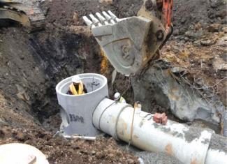
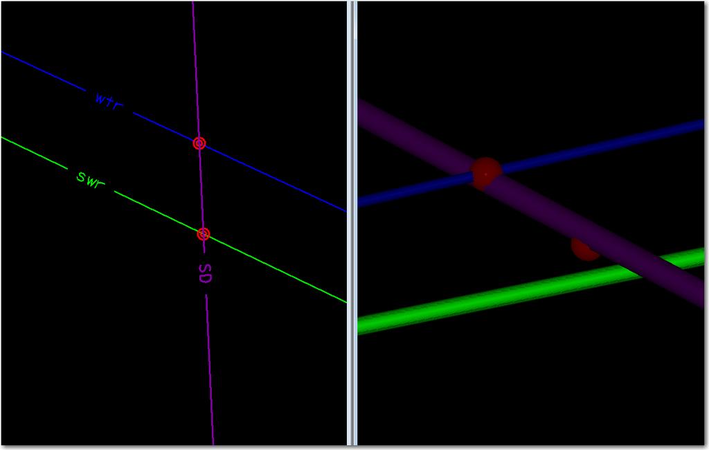
53 Premont Relief Route CRP District Clash Detection 3-D SUE can be incorporated into the 3-D Roadway Design file Clash Detection Allows the user to identify 2 separate sets (Set A and Set B) of 3-D graphical elements and detect clearance and physical clashes between the 3-D elements sets. Allows the user to interactively and graphically review these clashes, annotate particular clashes and assign the clashes as a conflict. Criteria Tab Specifies clearance window around 3-D elements in either of the 2 sets Example, if the elements in Set B get closer than the 6 inches or within the clearance window from Set A, then a clash will be reported, this is considered a clearance clash If elements in Set B physically touch elements in Set A, the clash is considered a hard clash Feb. 5,

54 SUDA Clash Detection Tool Feb. 5,

55 Clash Detection Nodes Feb. 5,
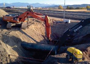
56 Premont Relief Route CRP District 3-D Deliverable Consultant 3-D Deliverable Feb. 5,

57 Premont Relief Route CRP District 3-D Deliverable Consultant 3-D Deliverable with road overlay Feb. 5,
 Feb.")
58 Premont Relief Route CRP District 3-D Deliverable Consultant 3-D Deliverable (Conflict Identified) Feb. 5,

59 Premont Relief Route CRP District 3-D Deliverable Consultant 3-D Deliverable Level A Test Holes Feb. 5,


60 Premont Relief Route CRP District Clash Detection Deliverable Design Division - Clash Detection Deliverable Feb. 5,
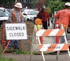
61 Lessons Learned Execute PEPS WA as early as possible schematic phase or 30% PS&E Scope additional Quality Level A Test Holes Utilize Level A Test Holes in initial investigation in areas of high conflict (ditches, bridges, channels, areas of cut, etc.) Minimum Level B on crossing utilities/utilities in high conflict areas For 3-D Deliverables, using electronic locating devices depths, checking elevations with Level A potholes. Scope in the WA, survey grade/as-built data on utility adjustments. Feb. 5,


62 Implementation of Bentley SUDA Bob Peterson, PE Methods Engineer
63 Implementation
64 Implementation Timeline September 2014 UDOT Implements InRoads SS3 February 2015 UDOT moves to SS4 version with SUE functionality July 2017 UDOT slowly (cautiously) moves to Open Roads Designer Reasons for Implementing Development of statewide utility Oracle database SUE integration with Oracle database Want to use as 3D graphic display Clash detection functionality
65 Workspace Development
66 Workspace Development Used resources (3D cell, feature definitions) from Bentley workspace Created cells for drainage boxes and manholes Drainage features developed but don t have prototype values assigned for drainage design Design in SS2 version and either display as solids or import the SDB file into SS4/ORD and assign features Consultant firm on project establishing prototype values that will be incorporated Using program for placing non-utility objects (sign posts, signals, delineators, etc) Places object at surface elevation (design or existing) Created objects that go below grade for clash detection
67 Challenges
 Challenges Generic 3D representation vs.")
68 Cells loose symbology/materials when placed with SUDA (cell has multiple material assignments element template only has one available) Challenges Generic 3D representation vs. realistic visual (power poles, hydrants)
 Database compacting message that dgn graphic didn t match database")
69 Challenges ORD Problems Slowness, limitation of profiles cut 3D cells may be too detailed What level of detail is needed? Product releases changing schema/functionality Cell rotation problem (just fixed) Database compacting message that dgn graphic didn t match database elements removed (what elements?)
70 Challenges Connecting to database securities, format SUE providers giving 3D data (only accurate at pothole location) Concern of liability if elevation incorrect Learn 3D layout tools
71 Future

72 Future Dgnlib that contains clash detection scenarios (soft clearance values for different utilities, testing criteria setting) Connectivity with Oracle database that is refreshed when new data I updated define feature mapping with SUDA Fully functioning drainage design workspace
73
74 For More Information Julie A Johnston, Utility & Value Engineering Program Manager FHWA Office of Infrastructure Preconstruction Team, HICP-10, MI Julie.johnston@dot.gov Cesar Quiroga, Sr. Research Engineer Texas A&M Trans. Institute - Reseach & Implementation, San Antonio C-Quiroga@tamu.edu Ross Gray, Project Manager Jacobs Ross.Gray@Jacobs.com AASHTO Web Page: FHWA Web Page: 74
Civil Product Update. Derricke Gray, Product Manager Bentley Civil Americas
 Civil Product Update Derricke Gray, Product Manager Bentley Civil Americas 1 WWW.BENTLEY.COM 2016 Bentley Systems, Incorporated 2016 Bentley Systems, Incorporated Agenda Civil Update o Where we are at
Advantages of Implementing StormCAD for OpenRoads (SUDA)
") Advantages of Implementing StormCAD for OpenRoads (SUDA) Robert Garrett, Bentley Systems Inc. WWW.BENTLEY.COM I 2015 Bentley Systems, Incorporated What is Subsurface Utility Design and Analysis? What is
Advantages of Implementing StormCAD for OpenRoads (SUDA) Robert Garrett, Bentley Systems Inc. WWW.BENTLEY.COM I 2015 Bentley Systems, Incorporated What is Subsurface Utility Design and Analysis? What is
Bentley s MicroStation Hydraulic Design/Analysis Software
 Bentley s MicroStation Hydraulic Design/Analysis Software October 17, 2018 Update on SUDA Development from 2017 SUDA Implementation Schedule SUDA/StormCAD Tools Management Tools Scenarios vs Alternatives
Programme TOC. CONNECT Platform CONNECTION Client MicroStation CONNECT Edition i-models what is comming
 Bentley CONNECT CONNECT Platform MicroStation CONNECT Edition 1 WWW.BENTLEY.COM 2016 Bentley Systems, Incorporated 2016 Bentley Systems, Incorporated Programme TOC CONNECT Platform CONNECTION Client MicroStation
3D DESIGN IN ALTERNATIVE DELIVERY Innovation, Savings, and Supplementing TxDOT Resources
 3D DESIGN IN ALTERNATIVE DELIVERY Innovation, Savings, and Supplementing TxDOT Resources Brief History 2 Conveying the Design Old Way Reviewing Changes Schematic Intent Design Change 3 4 Conveying the
3D Modeling Demonstration
 2014 Bentley Systems, Incorporated 3D Modeling Demonstration Derricke Gray, Product Manager Bentley Civil Americas ESS Statewide Rollouts: 3D Modeling Engineering Content Management (ProjectWise) 2 WWW.BENTLEY.COM
What's the Latest with InRoads Storm & Sanitary SS1?
 What's the Latest with InRoads Storm & Sanitary SS1? Joe Waxmonsky, Bentley Civil Why implement S&S? To avoid this: 2 WWW.BENTLEY.COM Single-source it 3 WWW.BENTLEY.COM StormCAD reads S&S files! StormCAD
OpenRail SELECTseries 4 - Managing Geometry and Corridor Modeling
 2015 Bentley Systems, Incorporated OpenRail SELECTseries 4 - Managing Geometry and Corridor Modeling Robert Nice Senior Application Engineer Agenda: Why work in SELECTseries 4? Moving to SELECTseries 4
Design, Drawing and Sheet Composition
 Design, Drawing and Sheet Composition Tools, Technologies and Concepts 1 WWW.BENTLEY.COM 2018 Bentley Systems, Incorporated 2018 Bentley Systems, Incorporated 2 WWW.BENTLEY.COM 2018 Bentley Systems, Incorporated
Ohio Department of Transportation, VBA Documentation
 Contents 1.1 Current Versions... 2 1.2 Overview... 3 1.3 Supporting Files and Standards... 4 1.3.1 ODOT_Drainage.cel... 4 1.3.2 ODOT2013.ddb... 5 1.4 ODOT_StormSewerPlan2013.mvba... 6 1.4.1 Mode: Place
OpenBridge Modeler: What is it and how can I use it today?
 2015 Bentley Systems, Incorporated OpenBridge Modeler: What is it and how can I use it today? Steve Willoughby, Senior Application Engineer Agenda: Introducing OpenBridge Modeler OpenBridge Modeler Features
Geospatial Keynote Nordic Civil konference I Vejle Bentley Systems, Incorporated 2016 Bentley Systems, Incorporated
 Geospatial Keynote Nordic Civil konference 07.11.2016 I Vejle 1 WWW.BENTLEY.COM 2016 Bentley Systems, Incorporated 2016 Bentley Systems, Incorporated Introduction Johannes Klick Senior Support Manager
Sustaining Water Infrastructure using Bentley Water Solutions
 Sustaining Water Infrastructure using Bentley Water Solutions February 2010. Slavco Velickov, PhD Water Industry Director, EMEA Agenda 1.Bentley at a Glance 2.Bentley Water Solutions 3.Water Products Overview
2014 NCLUG Summer Conference. Workshops
 Workshops [CM Workshop] NCDOT Corridor Modeler (CM) Delta Training (3 Day) [SS2] Oak Thammavong, NCDOT Creating & Customizing templates presented by NCDOT, Oak Thammavong. The Advanced OpenRoads Technology
8.1 Control. 8.2 Sheet Setup
 8.1 Control Responsibility for development of the pipe data sheets is in the hands of the project s drainage or roadway designer. Pipe data sheets should be developed after the drainage design is fairly
What s New in Bentley Civil SELECTseries 3
 What s New in Bentley Civil SELECTseries 3 Introducing OpenRoads Technology Ian Rosam Product Manger, Bentley Civil 1 WWW.BENTLEY.COM 2013 2013 Bentley Bentley Systems, Incorporated Bentley Civil/Transportation
Any student may retake any class at any time and for any reason without additional charge.
 1 ENVISIONCAD ABOUT US Guaranteed Training 1 ENVISIONCAD ABOUT US EnvisionCAD is a provider of training solutions for MicroStation and select InRoads products. We also use our expertise to assist organizations
OpenPlant. Hayley Brown Industry Consultant, Bentley Plant Bentley Systems, In
 OpenPlant Hayley Brown Industry Consultant, Bentley Plant tley Systems, In co Introduction What is OpenPlant? OpenPlant is the branding for the next generation of applications and tools based on ISO 15926
Full Contents. InRoads Essentials
 Section 1: Overview Essentials 1.1 Introduction... 3 Learning InRoads... 3 Basic Rules... 3 How to Use This Guide... 4 Section Breakdown... 5 Section 1: Overview Essentials... 5 Section 2: Production Essentials...
Integrated Life Cycle Management for Design, Modeling, and Operation of Stormwater Drainage Systems
 Integrated Life Cycle Management for Design, Modeling, and Operation of Stormwater Drainage Systems Robert Mankowski, P.E. Vice President, Water Infrastructure Asset Performance 1 WWW.BENTLEY.COM 2017
Using Dynamic Views. Module Overview. Module Prerequisites. Module Objectives
 Using Dynamic Views Module Overview The term dynamic views refers to a method of composing drawings that is a new approach to managing projects. Dynamic views can help you to: automate sheet creation;
How to Design and Submit a DOT Project with Civil 3D
 11/30/2006-5:00 pm - 6:30 pm Room:San Polo - 3503 (ISD Campus) How to Design and Submit a DOT Project with Civil 3D Seth Cohen - ProSoft NET CV35-2 This lab will delve into the workflows and processes
Full Contents. Essentials, Workbook
 Section 1: Overview Essentials 1.1 Introduction... 3 Learning InRoads... 3 Basic Rules... 3 How to Use This Guide... 4 Section Breakdown... 5 Section 1: Overview Essentials... 5 Section 2: Production Essentials...
Best Practice: Corridor Modeling
 2014 Bentley Systems, Incorporated Best Practice: Corridor Modeling Presented by: Joe Waxmonsky PE, Bentley Civil 2 WWW.BENTLEY.COM 2014 Bentley Systems, Incorporated Best Practice: Corridor Modeling Agenda
APPENDIX 1: CONSTRUCTION PLAN CHECKLIST
 APPENDIX 1: CONSTRUCTION PLAN CHECKLIST October 2017 APPENDIX A APPENDIX 1: CONSTRUCTION PLAN CHECKLIST ALL PLANS Plans on 24-inch by 36-inch paper (Originals shall be transmitted on a CD as an electronic
Plant & Process Electrical Design Introduction to I&W, promis e & BRCM
 2014 Bentley Systems, Incorporated Plant & Process Electrical Design Introduction to I&W, promis e & BRCM Rick Black- Industry Sales Director - Electrical Group EMEA 3 WWW.BENTLEY.COM 2014 Bentley Systems,
Improving efficiency of water utilities: practical examples
 Improving efficiency of water utilities: practical examples Slavco Velickov, PhD - Water Industry Director EMEA Geospatial Forum, Rotterdam, 23-26 May 2016 1 WWW.BENTLEY.COM 2016 Bentley Systems, Incorporated
D&C-LI. CADD Specification Manual. Version 1.3. Technical Services City of Toronto
 D&C-LI CADD Specification Manual Technical Services City of Toronto Version 1.3 Design & Construction Linear Infrastructure CADD Specification Manual Version 1.3 September 2012 The Design & Construction
Stream Design: From GEOPAK to HEC-Ras
 10 Stream Design: From GEOPAK to HEC-Ras OBJECTIVES Provide you with a general understanding of GEOPAK Cross Section Reports and their capability to generate geometric information for the HecRas program.
Implementing BIM for infrastructure: a guide to the essential steps
 Implementing BIM for infrastructure: a guide to the essential steps See how your processes and approach to projects change as you adopt BIM 1 Executive summary As an ever higher percentage of infrastructure
Bentley Civil Update and Direction
 www. bentley. com Bentley Civil Update and Direction Mike Wilson Director, Software Development, Bentley Civil The cast of characters this year Bentley Civil Mike Wilson that would be me Director, Software
CHAPTER 15. Cross Section Sheets. None, except batch processing of an input file.
 CHAPTER 15 Cross Section Sheets 15.1 Introduction Objectives Project Manager Menu Bar Application Learn the procedures for laying out cross section sheets. Cross Section Sheets None, except batch processing
X11-Using the New Civil Geometry Tools
 X11-Using the New Civil Geometry Tools Joe Waxmonsky, PE Bentley Civil 2010 Bentley Systems, Incorpo ora 2010 Bentley Systems, Incorpora 2010 Nordic Civil Geometry 2 WWW.BENTLEY.COM Roads and Bridges 2010
OpenRoads Designer Best Practices Project Management
 OpenRoads Designer Best Practices Project Management Presented by: Ian Rosam, Director Civil Product Management, Bentley Systems, Inc. 1 WWW.BENTLEY.COM 2017 Bentley Systems, Incorporated 2017 Bentley
GEOPAK V8i SELECTseries 1, Road 2
 GEOPAK V8i SELECTseries 1, Road 2 Ohio Department of Transportation October, 2012 Ohio Department of Transportation GEOPAK Road Training Guide for MicroStation V8i SELECTseries 1, October, 2012 The information
Guidelines for the Preparation of ITS & Signal Plans by Private Engineering Firms
 Guidelines for the Preparation of ITS & Signal Plans by Private Engineering Firms INTRODUCTION Use the following Guidelines in conjunction with the ITS & Signals Scope of work provided in the Project Scoping
Full Contents. Survey V8.08 Essentials
 Section 1: Overview Essentials 1.1 Introduction... 3 Learning InRoads Survey... 3 Basic Rules... 3 How to Use This Guide... 4 Section Breakdown... 5 Section 1: Overview Essentials... 5 Section 2: Production
Minimum Drawing & Electronic Submittal Requirements For Record Drawings /As-Builts
 Minimum Drawing & Electronic Submittal Requirements For Record Drawings /As-Builts PUBLIC WORKS ENGINEERING DEPARTMENT Revised: February 1, 2017 MINIMUM DRAWING REQUIREMENTS A. GENERAL PLAN REQUIREMENTS:
AECOsim Building Designer. Quick Start Guide. Chapter 2 Making the Mass Model Intelligent Bentley Systems, Incorporated.
 AECOsim Building Designer Quick Start Guide Chapter 2 Making the Mass Model Intelligent 2012 Bentley Systems, Incorporated www.bentley.com/aecosim Table of Contents Making the Mass Model Intelligent...3
AECOsim Building Designer. Quick Start Guide. Chapter A08 Space Planning Bentley Systems, Incorporated
 AECOsim Building Designer Quick Start Guide Chapter A08 Space Planning 2012 Bentley Systems, Incorporated www.bentley.com/aecosim Table of Contents Space Planning...3 Sketches... 3 SpacePlanner... 4 Create
Agenda 2 Bentley Overview. Solutions. Bridges. Buildings 4 Bentley Overview
 Agenda Attendees will learn about how to improve efficiencies by transferring AutoPLANT, PlantSpace, PDS and 3D CAD models to engineering analysis piping and structural models. A demonstration will be
2014 Bentley Systems, Incorporated. Bentley Rail Track SELECTseries2 Maintenance Release
 2014 Bentley Systems, Incorporated Bentley Rail Track SELECTseries2 Maintenance Release Topics Look back What's in the latest release What's next 2 WWW.BENTLEY.COM 2014 Bentley Systems, Incorporated Previous
Bentleyuser.dk Årsmøde 2010 Nordic Civil 2010
 Bentleyuser.dk Årsmøde 2010 Nordic Civil 2010 8.-10. November 2010, Munkebjerg Hotel, Vejle Workshop - X9 Resurfacing and Overlay Tools InRoads V8i Presenter: Joe Waxmonsky, P.E., Bentley Systems USA Bentley
Subsurface Utility Engineering and 3D Utility Mapping
 Subsurface Utility Engineering and 3D Utility Mapping Subsurface Utility Engineering: A branch of engineering practice that involves managing certain risks associated with utility mapping and appropriate
Please See NEXT PAGE for Class Selection
 SoCal Bentley Bash 2019 - January 11th - FRIDAY REGISTRATION FORM PLEASE PRINT - Use a separate form for each person registering For Admin Use Only *First Name *Last Name Company/School* *Address *City
Design of Sanitary Sewer Network using Sewer GEMS V8i Software
 IJSTE - International Journal of Science Technology & Engineering Volume 2 Issue 01 July 2015 ISSN (online): 2349-784X Design of Sanitary Sewer Network using Sewer GEMS V8i Software Murugesh Katti Krishna
CHAPTER 11 SURVEY CADD
 CHAPTER 11 SURVEY CADD Chapter Contents Sec. 11.01 Sec. 11.02 Sec. 11.03 Sec. 11.04 Sec. 11.05 Sec. 11.06 Sec. 11.07 Sec. 11.08 Sec. 11.09 Sec. 11.10 General Description of Survey File Contents of Survey
3. The PAC (Permit Application Center) will notify the design professional of plan review results.
 will notify the design professional of plan review results.") Planning and Development Dept. Infrastructure Division P.O. Box 11706, or 155 Johnston Street Rock Hill, South Carolina 29731-1706 Phone: 803-329-5515 FAX: 803-329-7228 www.cityofrockhill.com AS-BUILT
Planning and Development Dept. Infrastructure Division P.O. Box 11706, or 155 Johnston Street Rock Hill, South Carolina 29731-1706 Phone: 803-329-5515 FAX: 803-329-7228 www.cityofrockhill.com AS-BUILT
Bentley Substation 2010 Bentley Systems, Incorporated Håkan Norling Bentley Professional Services
 www.bentley.com Bentley Substation Håkan Norling Bentley Professional Services Agenda, 12 th of November 2010 Bentley s Substation design solution Integration of primary- and secondary design based on
Ohio Department of Transportation. CADD Engineering Standards Manual (ODOTcadd)
") Ohio Department of Transportation CADD Engineering Standards Manual (ODOTcadd) 4/21/2017 Table of Contents Table of Contents... i 100 GENERAL... 1 101 Introduction... 1 101.1 Software... 2 102 Distribution...
Ohio Department of Transportation CADD Engineering Standards Manual (ODOTcadd) 4/21/2017 Table of Contents Table of Contents... i 100 GENERAL... 1 101 Introduction... 1 101.1 Software... 2 102 Distribution...
LA DOTD Electronic Plans Breaking New Ground
 LA DOTD Electronic Plans Breaking New Ground Louisiana Transportation Engineering Conference Baton Rouge River Center February 13, 2007 Presented by Hollis Ward Electronic Plans - A Team Effort Bridge
AGENDA: BIM Introduction. Large-Scale Value. Value for Architects. Conceptual BIM / Small BIM. All-Out BIM. BIM Introduction
 From Conceptual BIM to All-Out BIM Brent Mauti, Architect BARCH, OAA, MAA, SAA, AAA, MRAIC, NCARB, AIA, LEED-AP CH2M HILL CANADA ARCHITECTS INC. brent.mauti@ch2m.com Member of the Manitoba Association
Bentleyuser.dk ÅRSMØDE 2011 Vejle,
 2011 Bentley Systems, Incorporated Bentleyuser.dk ÅRSMØDE 2011 Vejle, 14.+15.11.2011 Bentley OpenPlant Update Carsten Gerke Senior Sales Director Bentley Plant EMEA Today s Agenda 2010 Bentley Systems,
PDS V8 SE Training Course Highlights
 PDS V8 SE Training Course Highlights Course Number Title Est. No of Days Per Enrollment (US $) On-Site Excl. Travel (US $) TPDS3113 PDS 3D Theory 4 2000 10000 TPDS3100 PDS Project Administration 4 2000
9 LAND SURVEYING. 9.1 General. 9.2 Administrative Requirements Standards Meetings Survey Data Provided to the Design-Builder
 9 LAND SURVEYING 9.1 General The Design-Builder shall conduct all Work necessary to meet the requirements associated with land surveying, including Project and supplemental horizontal and vertical control
Bentley Rail Track Update
 Bentley Rail Track Update Robert Nice Bentley Systems UK Recent Past and Near Future Today, I will discuss recent enhancements to Bentley Rail Track. Some of these enhancements you may be very familiar
OpenRoads Best Practice - Civil Cells
 OpenRoads Best Practice - Civil Cells Presented by: Ian Rosam, Director Civil Product Management, Bentley Systems, Inc. 1 WWW.BENTLEY.COM 2017 Bentley Systems, Incorporated 2017 Bentley Systems, Incorporated
SECTION 2.0 PREPARATION OF MASTER PLANS, CONSTRUCTION PLANS, AND RECORD DRAWINGS
 SECTION 2.0 PREPARATION OF MASTER PLANS, CONSTRUCTION PLANS, AND RECORD DRAWINGS 2.1 MASTER PLAN 2.1.1 A Master Plan for water, wastewater, and/or reclaimed water is required for all residential or commercial
Field Asset Data Collection and Integration with the Enterprise Database
 Incorporated Field Asset Data Collection and Integration with the Enterprise Database Marc Kratzschmar & Ian Martin 2011 GIS-T Overview British Columbia asked for help Needed asset data collection application
Guidelines for the Preparation of Traffic Signal & Intelligent Transportation System Plans on Design-Build Projects August 2007
 Guidelines for the Preparation of Traffic Signal & Intelligent Transportation System Plans on Design-Build Projects August 2007 INTRODUCTION Use the following Guidelines in conjunction with the Traffic
Practice Workbook. Cross Sections: Creating, Annotating, and Volumes. SELECTseries 4 ( ) or newer
 or newer") Practice Workbook This workbook is designed for use in Live instructor-led training and for OnDemand self study. The explanations and demonstrations are provided by the instructor in the classroom, or
Practice Workbook This workbook is designed for use in Live instructor-led training and for OnDemand self study. The explanations and demonstrations are provided by the instructor in the classroom, or
Wholly Sheets, Batman - Plotting in AutoCAD Civil 3D Seth Cohen Advanced Technologies Solutions Inc.
 Seth Cohen Advanced Technologies Solutions Inc. CV637 Are you confused about how to plot all the different views (plan, profile, and cross sections) in AutoCAD Civil 3D software? Then this class is for
ACSA PLAN REVIEW CHECKLIST (Guideline Only) (4) Standard water and sewer general plan notes (attached).
 (4) Standard water and sewer general plan notes (attached).") ACSA PLAN REVIEW CHECKLIST (Guideline Only) Revised: December 3, 2015 General (1) Proper Title (2) Vicinity map on first sheet. (3) Date and latest plan revision. (4) Standard water and sewer general plan
ACSA PLAN REVIEW CHECKLIST (Guideline Only) Revised: December 3, 2015 General (1) Proper Title (2) Vicinity map on first sheet. (3) Date and latest plan revision. (4) Standard water and sewer general plan
Survey Data and TOPO Checklist
 Checklists Survey Data and TOPO Preliminary Plan Field Review Plans o Field Review Erosion Control Right-of-Way and Utility Meeting Plans Final Plan Field Review Plans Methods of Plan Markups Plan-in-Hand
Practice Workbook. Cross Sections: Creating, Annotating, and Volumes
 Practice Workbook This workbook is designed for use in Live instructor-led training and for OnDemand selfstudy. The explanations and demonstrations are provided by the instructor in the classroom, or in
Essential Skills: Reading and Interpreting Maps and Plans
 Essential Skills: Reading and Interpreting Maps and Plans Prepared for: NEW YORK STATE PLANNING FEDERATION April 14, 2015 Prepared by: BME ASSOCIATES Peter G. Vars, P.E. Stages of Plan Review Concept /
Project Overview Mapping Technology Assessment for Connected Vehicle Highway Network Applications
 Project Overview Mapping Technology Assessment for Connected Vehicle Highway Network Applications AASHTO GIS-T Symposium April 2012 Table Of Contents Connected Vehicle Program Goals Mapping Technology
BC Ministry of Transportation and Infrastructure Civil 3D Terms of Reference
 BC Ministry of Transportation and Infrastructure Civil 3D Terms of Reference BC Supplement to TAC Section 1280 [January 2017 - Provisional] BLANK PAGE Contents 1280.01 General... 1 1280.02 Terms of Reference:
Sheet Metal OverviewChapter1:
 Sheet Metal OverviewChapter1: Chapter 1 This chapter describes the terminology, design methods, and fundamental tools used in the design of sheet metal parts. Building upon these foundational elements
Public Projects Plan Submittal Guidelines Revised August 4, 2017 Plan submittal Process: 10% Plans 25% Plans 30% Plans 60% Plans 90% Plans
 Plan submittal Process: 10% Plans - Based on survey and include detailed horizontal geometry per Public Project Checklist. 25% Plans - Plans include profiles, typical sections, phasing & cross sections
MINIMUM DRAWING REQUIREMENTS FOR WATER AND SEWER LINE PROJECTS
 Public Works Department Water & Wastewater Services WATER & WASTEWATER ENGINEERING DIVISION 2555 West Copans Road Pompano Beach, Florida 33369 954-831-0745 FAX 954-831-0798/0925 MINIMUM DRAWING REQUIREMENTS
Work Type Definition and Submittal Requirements Work Type: Subsurface Utility Engineering (SUE)
") MUST be qualified under Minnesota Department of Transportation Prequalification Program - Work Type 15.1 Subsurface Utility Engineering The first section, Work Type Definition, provides a detailed explanation
MUST be qualified under Minnesota Department of Transportation Prequalification Program - Work Type 15.1 Subsurface Utility Engineering The first section, Work Type Definition, provides a detailed explanation
AutoPLANT Product Update
 AutoPLANT Product Update DK User Meeting 15 th November 2011 Chris Binns AutoPLANT Product Manager Agenda Introduction to me... Where we are today... AutoPLANT V8i (SELECTseries 3) Where we are going...
SECTION 3 IMPROVEMENT PLAN REQUIREMENTS
 SECTION 3 IMPROVEMENT PLAN REQUIREMENTS CONTENTS Page 3-1 Digital Submittals 3-2 3-2 Paper Size and Scale 3-2 3-3 Drafting Standard 3-2 3-4 Title Sheet 3-2 3-5 Title Block 3-3 3-6 Drainage, Sewer, Water,
Exercise 1: The AutoCAD Civil 3D Environment
 Exercise 1: The AutoCAD Civil 3D Environment AutoCAD Civil 3D Interface Object Base Layer Object Component Layers 1-1 Introduction to Commercial Site Grading Plans AutoCAD Civil 3D Interface AutoCAD Civil
i-models Kansas City Revit Users Group September, 2013
 i-models Kansas City Revit Users Group September, 2013 Agenda i-model Definition Creation of i-models from Revit Reading an i-model Bentley Users collaborating with Revit Users Bentley View free Bentley
Detail Design for State Project
 Introduction and Project Information Detail Design for State Project 4210-49 Introduction This contract includes detailed design to letting for the shoulder widening of Trunk Highway (TH) 68 between the
State of Florida Department of Transportation. FDOT Traffic Plans. Signing & Pavement Markings (CE ) Signalization (CE ) Lighting
 Signalization (CE ) Lighting") State of Florida Department of Transportation FDOT Traffic Plans Signing & Pavement Markings (CE-11-0117) Signalization (CE-11-0119) Lighting (CE-11-0118) User Training Manual October 2017 PRODUCTION SUPPORT
State of Florida Department of Transportation FDOT Traffic Plans Signing & Pavement Markings (CE-11-0117) Signalization (CE-11-0119) Lighting (CE-11-0118) User Training Manual October 2017 PRODUCTION SUPPORT
Introducing Bentley Map VBA Development
 Introducing Bentley Map VBA Development Jeff Bielefeld Session Overview Introducing Bentley Map VBA Development - In this session attendees will be provided an introductory look at what is required to
Future of Bentley Plant applications: AutoPLant and OpenPlant
 1 WWW.BENTLEY.COM 2013 Bentley Systems, Incorporated Future of Bentley Plant applications: AutoPLant and Magnus Cullberg 2 WWW.BENTLEY.COM 2013 Bentley Systems, Incorporated AutoPLANT Modeler AutoPLANT
SD DEPARTMENT OF TRANSPORTATION OFFICE OF ROAD DESIGN
 SD DEPARTMENT OF TRANSPORTATION OFFICE OF ROAD DESIGN CADD Procedures Manual Section B - Design 1 Table of Contents InRoads Master Workflow... 3 Getting Started... 3 Open InRoads Files... 3 Create and
3D Technologies Implementation - SE Freeways Design Wisconsin Department of Transportation
 3D Technologies Implementation - SE Freeways Design Wisconsin Department of Transportation Bob Gutierrez, P.E. Chief Southeast Freeways Design, WisDOT $1.7 b reconstruction of Zoo IC-Corridor WisDOT SE
Existing and proposed contours at 1-foot intervals. The fill and/or excavation quantities in cubic yards.
 PLAN REQUIREMENTS The plans for street design shall conform to the requirements of Sections 3 and 4. The following requirements shall also be shown on the plans where applicable. Road and Storm Plans:
GIS-Based Plan and Profile Mapping
 GIS-Based Plan and Profile Mapping ESRI International User Conference 2010 July 12-16, 2010 Maik Flanagin U.S. Army Corps of Engineers, MVN New Orleans, Louisiana maik.c.flanagin@usace.army.mil Sam Falchook
A selection of files of content to give the out of the box experience of a local product. Local standards in drawing production, design and reporting
 A t CAD Civil AutoCAD Ci il 3D 2011 UK and Ireland Country Kit Jack Strongitharm Application Engineer What is a Country Kit? A selection of files of content to give the out of the box experience of a local
Crashing into Field to Finish in one (1) hour. Let s see what we can do!
 hour. Let s see what we can do!") Crashing into Field to Finish in one (1) hour Let s see what we can do! Using the term Field to Finish For todays purpose, we will be using the term field to finish as a generic term for using codes, to
Crashing into Field to Finish in one (1) hour Let s see what we can do! Using the term Field to Finish For todays purpose, we will be using the term field to finish as a generic term for using codes, to
STATE UNIVERSITY CONSTRUCTION FUND
 DIRECTIVE 1C-12 Issue date: August 2012 1. General SURVEY, MAPPING AND UTILITY LOCATING This Directive has been developed as a general guide for the survey and mapping effort required for Fund projects.
TABLE OF CONTENTS 1200 PLAN PREPARATION
 1200 PLAN PREPARATION TABLE OF CONTENTS PAGE 1201 General Plan Sheet Information... 12-1 1201.1 Introduction... 12-1 1201.2 Unit of Measure... 12-1 1201.3 Plan Sheet Materials and File Format... 12-1 1201.4
Maintenance of Traffic sequence of operations including any phasing and detour maps;
 All Local-let projects are required to have a Stage 2 submittal to the LPA Manager for review. The only exceptions are 2-lane resurfacing, striping, guardrail, and raised pavement markers, unless otherwise
AutoCAD Civil 3D 2013 South African Country Kit
 AutoCAD Civil 3D 2013 South African Country Kit Contents 1 General... 3 1.1 Introduction from the author and creator... 3 1.2 Overview... 4 2 Drawing Settings... 8 2.1 Edit Drawing Settings... 8 3 Layers...
AVEVA PDMS. Business Benefits. Accurate and clash-free 3D plant design
 AVEVA PDMS Accurate and clash-free 3D plant design With ever increasing global demand for products from process and power plants, AVEVA PDMS enables companies to design, construct and maintain high quality
HVAC in AutoCAD MEP: New and Improved. David Butts Gannett Fleming MP3724-L. Learning Objectives. At the end of this class, you will be able to:
 David Butts Gannett Fleming MP3724-L In the Building Information Modeling (BIM) world, there are still many users who have AutoCAD MEP but aren't ready to make the move to Autodesk Revit for a variety
PART XII: TOPOGRAPHIC SURVEYS
 PART XII: TOPOGRAPHIC SURVEYS 12.1 Purpose and Scope The purpose of performing topographic surveys is to map a site for the depiction of man-made and natural features that are on, above, or below the surface
Smart 3D Plant/Outfitting Curriculum Path & Training Guidelines
 Smart 3D Plant/Outfitting Curriculum Path & Training Guidelines Intergraph PPM recommends that new Smart 3D plant/outfitting users select one of the following training tracks described below. 1. System
CADD & Civil 3D User Guidelines
 THURSTON COUNTY PUBLIC WORKS DEPARTMENT Design and Construction Division CADD & Civil 3D User Guidelines V4.0_06_10_15 1 THURSTON COUNTY PUBLIC WORKS DEPARTMENT DESIGN AND CONSTRUCTION DIVISION CADD &
Port of Long Beach Engineering. CADD Standards Manual
 Port of Long Beach Engineering CADD Standards Manual Port of Long Beach CADD Standards Manual June 10, 2010 Current Standards Version: 1.3 Revision History: 1.2 Draft released December, 2009 1.1 Draft
CHAPTER 2C - PRELIMINARY DESIGN. General... 2C-1. Review of Work Load... 2C-2 Establishing Priorities... 2C-2
 SECTION 2C - 1 - PROJECT REVIEW CHAPTER 2C - PRELIMINARY DESIGN General... 2C-1 SECTION 2C - 2 - COORDINATING TIME SCHEDULES Review of Work Load... 2C-2 Establishing Priorities... 2C-2 SECTION 2C 3 - REVIEW
SURVEYING THE UNDERGROUND
 SURVEYING THE UNDERGROUND An Introduction to the Practice of Subsurface Utility Engineering Maryland Society of Surveyors Maryland Society of Professional Engineers Joint Conference October 8, 2015 Michael
Dowel Bar Standardization. NC^2 Fall Meeting St. Louis, MO
 Dowel Bar Standardization 2001 Universal Basket Continuation of discussion from NC^2 Spring meeting Results of Dowel Bar Questionnaire Results of Dowel Bar Questionnaire Dowel Bar Diameters 6.0" 6.5" 7.0"
Plan Preparation Checklist
 Appendix D Plan Preparation Checklist It is the responsibility of the Designer to complete and submit this checklist along with all required drawings for OUC (EFP) Review. All drawings submitted for OUC