Geospatial Keynote Nordic Civil konference I Vejle Bentley Systems, Incorporated 2016 Bentley Systems, Incorporated
|
|
|
- Earl Lang
- 5 years ago
- Views:
Transcription

1 Geospatial Keynote Nordic Civil konference I Vejle Bentley Systems, Incorporated 2016 Bentley Systems, Incorporated

2 Introduction Johannes Klick Senior Support Manager Surveying Engineer and works since over 20 years in the Utility GIS Industry of which 15 years for Bentley Specialist in Utilities, responsible for managing and implementing Bentley Utility products like Bentley sisnet at customers. Manages the EMEA Application Engineer team who provide the Account and Product Advancement teams with mapping and utilities expertise; support Bentley s Asset Advancement Solutions, including BentleyOpenUtilities, Bentley Map, Mobile Apps, H&H, AssetWise Applications etc Bentley Systems, Incorporated

3 Mapping, 3D Modeling and Infrastructure Trends? Bentley Systems, Incorporated


4 Bentley Systems, Incorporated

5 Bentley Systems, Incorporated

6 Bentley Systems, Incorporated


7 Reality Modeling High resolution, high accuracy Bentley Systems, Incorporated


8 Mobility Bentley Systems, Incorporated
9 Bentley Systems, Incorporated Quite a challenge
10 Bentley Map for Your Customer Add the best value in workflows that require accurate modeling of 2D and 3D assets. Roads Rail Utilities Cadastre 3D city models Strong interoperability with GIS formats and spatial databases SHP, MapInfo, GML Oracle Spatial, SQL Server Spatial Analytical tools mean the user does not require GIS for common tasks Buffers, overlays, labeling, thematic mapping Strong ecosystem of complimentary products AssetWise ContextCapture, LumenRT Bentley SELECT Bentley Systems, Incorporated
11 Bentley Map for Your Business Many opportunities for value add Project customization through the geospatial administrator Custom applications using the Bentley Map SDK to support local standards and language Cost effective application delivery Bentley Map PowerView No application license required Bentley Systems, Incorporated

12 Who buys Bentley Map? Municipalities Mapping Cadastre Utilities Electric and gas utilities Campuses airports university army bases Surveyors Departments of Transportation Bentley Systems, Incorporated
13 Bentley Map Capabilities Bentley Systems, Incorporated 2016 Bentley Systems, Incorporated


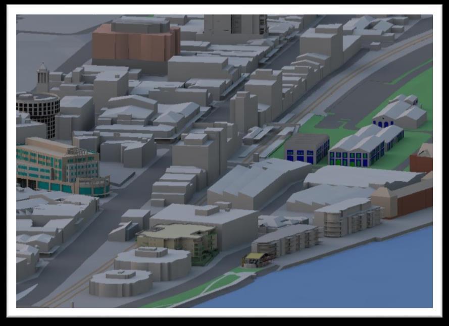
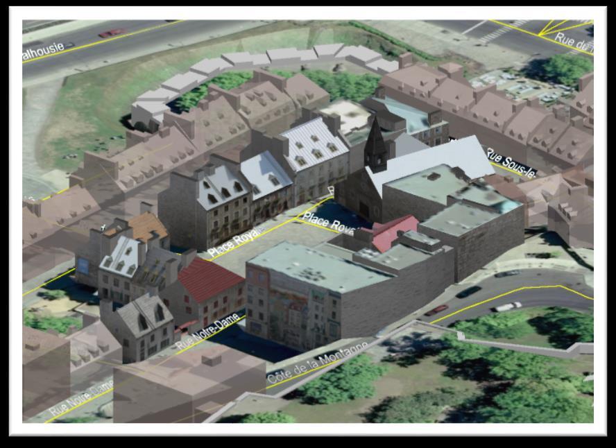
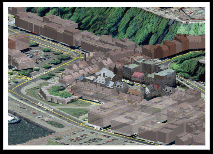
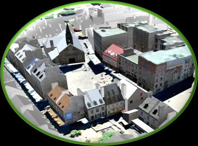
14 Bentley Map GIS with the Power of MicroStation Engineering-grade quality Interoperability Spatial Databases Image, Point Clouds and Scalable Terrain Models Spatial Analysis Map Finishing and Printing Tools Model courtesy of City of Quebec Bentley Systems, Incorporated

15 The Power of MicroStation Engineering Accuracy AccuDraw AccuSnap Excellent feature creation and editing Raster Management Geographic Coordinate System Reference other geolocated designs and raster data Displaying and entering latitude and longitude Interfacing with a GPS device Full 3D Modeling Animations, Visualizations, Shadow Studies Model courtesy of City of Quebec Bentley Systems, Incorporated

16 Interoperability Import, export and directly reference a variety of common geospatial formats SHP, MapInfo, GML, CSV, ODBC, Esri FGDB WFS (Web Feature Service) Query and import, Spatial Data Streaming Remap feature and property names and assign symbology Save settings for reuse and bulk operations Interface to FME for many more formats Bentley Systems, Incorporated

17 Spatial Database Support Oracle Spatial and SQL Server Spatial Vector Query, Lock, Edit, Post Spatial Data Streaming and Direct Data Access Oracle Spatial Long and short transaction Textures and Raster Non Top View Queries of 3D Data Oracle 12c - B-Spline Curves and Non- Circular Arcs Composite Primary Key, Support Views As Sub-Features Bentley Systems, Incorporated

18 Thematic Maps Thematic maps Communicate a topic or theme Features resymbolized based on associated non-graphical attributes Represents spatial distribution of data Scientific, statistical or informational data Can emphasize spatial variations and interrelationships in the data being mapped Bentley Systems, Incorporated

19 Spatial Analysis Buffers and Overlays Performs analytical operations on Bentley Map features Buffers define areas around features Overlays combine two layers Used to provide answers to questions such as: Which parcels are within 5km of a sour gas well? Which properties are within 400m of a park and 500m away from a busy road? Which manholes are within 5 meters of sidewalks? Bentley Systems, Incorporated

20 Imaging and Point Clouds Advanced Processing Platform for 3D Imagery Efficient display of point clouds Flexible presentation modes Advanced point cloud tools: Clip and Section Manager, Model by Section, and geometry extraction tools Advanced image editing for binary and color images Support for hybrid environments Bentley Systems, Incorporated


21 Scalable Terrain Models Display terrain models with billions of points Create models from a variety of sources: DEM, DGN, Point cloud Automatically detect when source file has been changed to trigger rebuild of STM Real-time display of contours, triangles, elevation, aspect and hill shading as well as draped imagery Bentley Systems, Incorporated

22 Clash Detection Compare solids against point clouds Point clouds used in their native format Eliminates the need to extract geometry Find hard and soft clashes Anticipate future clashes Generate reports Bentley Systems, Incorporated


23 ContextCapture Integration Display Reality Mesh in Bentley Map Local attachment URL attachment Fast, real time display Clipping, masking Snapping for modeling and measuring Bentley Systems, Incorporated


24 Geospatial Developers Geospatial Developer Extranet Bentley Map Development Guide Code samples Development Support No special license requirements Bentley Systems, Incorporated

25 150 Geospatial Partners and Developers Bentley Systems, Incorporated
26 Sample Geospatial Developers Company Country Applications Geodezy Poland Surveying Verizon United States Telecommunications LE34 Denmark Surveying Crotec Netherlands Cadastral HSI Czech Republic Telecommunications Terrasolid Finland 3D modeling Bentley Systems, Incorporated

27 Bentley Map API Key Benefits high-level geospatial functionality to increase application performance and reduce development time. an object-oriented interface which encapsulates feature geometries and business properties. leverage the same core geospatial functionalities and data modeling capabilities used by other Bentley applications. The Bentley Map API contains ~3,200 additional functions Bentley Systems, Incorporated

28 Other Geospatial Products Bentley Systems, Incorporated 2016 Bentley Systems, Incorporated


29 Bentley Map Mobile take your geospatial data to the field Easy to Use Pinch to zoom, touch to select AccuSnap capabilities Advanced tools Query tool Detailed measuring tools Coordinate read-outs GPS integration (Google Maps or Apple Maps) Redlines and Markups Delta change updates Disconnected operation Bentley Systems, Incorporated

30 Hydraulic modeling applications Hydraulic modeling as decision support: Water Distribution Wastewater Collection Stormwater Conveyance Site Design <pictures> Bentley Systems, Incorporated
31 Utility Lifecycle Needs Planning and Design Evaluate long-term master planning considerations Study the impact of population shifts, conservation efforts, etc. Prioritize capital planning to balance service needs Meet regulatory requirements Improve public safety Increase system reliability and reduce failure risks Operations and Maintenance Perform maintenance with minimal service disruptions Predict performance to improve operational planning Increase pumping efficiency and reduce energy costs Evaluate different operational strategies Respond quickly and effectively to emergencies Bentley Systems, Incorporated

32 Improve the Performance of Urban Water Infrastructure Comprehensive water solution to: Address the entire water lifecycle Map, analyze, design, operate, and manage water infrastructure Mitigates risks of poorly coordinated project information Bentley Systems, Incorporated

33 Improve the Performance of Urban Water Infrastructure Master plan preparation tools, to: Enable intelligent planning Deliver clean water safely with the least possible disruption Ensures system reliability Bentley Systems, Incorporated


34 Rehabilitation Existing Infrastructure Evaluation of capacity Find/fix bottlenecks Improve overall system Lower capital investments Bentley Systems, Incorporated


35 Design New Infrastructure Automated constraintbased design Minimize design costs and capital investments Maximize performance Bentley Systems, Incorporated


36 Operations Engineering support of operations Pump modeling Criticality and flushing analysis Plan operations Reduce energy use Track water quality Plan shutdowns Reduce energy costs Reduce customer complaints Bentley Systems, Incorporated


37 Operations Emergency response Fire flow, transient, water quality, flushing and criticality analyses Increase knowledge and understanding of system operations Reduce emergency response time Improve decision making Bentley Systems, Incorporated


38 Hydraulics and Hydrology Product Line Potable Water Distribution and Transmission WaterGEMS WaterCAD HAMMER Wastewater Collection Stormwater Systems CivilStorm StormCAD PondPack CulvertMaster FlowMaster SewerGEMS SewerCAD Bentley Systems, Incorporated

39 Efficient Operations Objectives Limiting water losses, including leakage Optimizing pump scheduling System efficiency Outcomes Reduced operating costs Reduced carbon footprint Bentley Systems, Incorporated


40 Improved Emergency Response Objectives Detecting and alerting abnormal behaviors in a timely manner Presenting short-term planning results to non-specialist staff Outcomes Increased public safety Faster emergency response Bentley Systems, Incorporated

41 Site Engineering Needs Design and analysis for: Stormwater management Wastewater collection Water distribution Bentley Systems, Incorporated


 47 WWW.BENTLEY.")
42 Site Engineering Capabilities Balance performance and cost Accurate analysis and automated design Easily compare alternative designs Streamline regulatory approval process Design to local guidelines and constraints Customize report templates to meet reviewer requirements Work more efficiently Choose any interface to work within (Stand-Alone, MicroStation, AutoCAD, ArcGIS) Bentley Systems, Incorporated
43 WaterObjects.NET Programming API Means of extending the capabilities of the model to do: Pre-processing Calculations Post-processing Graphical Editor Windows Forms, Trees, etc. Tables, Charts, Reports Data Management Scenario Management Numerical Engines Undo/Redo, Event Channels Bentley Systems, Incorporated

44 Utilities Networks Challenges and Opportunities Infrastructure sustainment Aging assets at or past lifetime Integration new technology Aging workforce Experienced workers retiring Difficulty attracting and training new workers Regulatory compliance Reporting and change management requirements Time consuming audits and costly fines Financial pressure Reduce cost without sacrificing reliability or safety Offset increases in cost of labor, construction, compliance Bentley Systems, Incorporated
45 Who buys Bentley OpenUtilities Solutions? Municipal water and waste water departments Electric and gas utilities Campuses airports university army bases District Heating Bentley Systems, Incorporated


46 OpenUtilities A utility network design tool Standard data models for electric, gas, water, wastewater and district heating On-the-fly cost estimation with breakdowns of labor, materials and equipment Configurable workflow engine Integration with Bentley s network modeling and analysis products Increases productivity, accelerates projects, and reduces software costs Bentley Systems, Incorporated


47 OpenUtilities Benefits Data will be precise as well as reliable and robust Engineering will have no duplication or data loss Quick implementation No additional license costs for adding network types Affordable Capex and Opex Can be offered as Cloud Service Costs Project Duration Regulatory Risks Reliability Bentley Systems, Incorporated

48 Bentley OpenUtilities Versions Bentley OpenUtilities Designer Enterprise GIS for design and management of utility networks Bentley OpenUtilities Map Utilities-specific GIS for network mapping and decision support Bentley OpenUtilities PowerView Streamlined, cost-effective application to review, explore, and markup utility network designs and maps Bentley Systems, Incorporated


49 Communications Business Challenges and Opportunities Recruit and Retain Customers Timely offerings Superior customer service Competitive pricing Increase Capacity and Reliability Rapid fulfillment of service orders Expand service areas Network monitoring and predictive maintenance Optimize Budget and Delivery Reducing costs while improving service Apply investment funds effectively Deliver projects on time, on budget Bentley Systems, Incorporated


50 While Change Continues to Accelerate TIME-TO-SERVICE COMPETITION Define new and better service offerings Shorten time-to-market Cloud, Internet of Things, Industrial, Energy Automation of service fulfillment processes Timely network builds and upgrades Speedy outage restoration BUDGET Too much to do not enough money Network technology quickly becomes obsolete Replacement of legacy plant in the field Bentley Systems, Incorporated

51 Who buys Bentley Communications Solutions? Cable and Telecom Providers Communications Contractors Departments of Transportation Mining Railroad Utilities Anyone who runs a communication network Bentley Systems, Incorporated


52 Bentley Communications Solution...is a suite of communications network design and management software capabilities for professionals to design and manage as-built records of outside and inside plant. Engineer Fiber Networks Engineer HFC Networks Engineer Inside Plant Engineer POTS Networks Engineer Communications Towers Manage Inside Plant Manage Outside Plant Publish Network Model Mobile mapping and analysis for communications field workers Emergency Preparedness and Response applications for the field Bentley Systems, Incorporated


53 Communications GIS and Network Engineering Network engineering to drive your bottom line Bentley Coax Bentley Fiber Bentley Inside Plant Bentley Expert Designer Communications Bentley Communications PowerView Bentley Geo Web Publisher for Communications Bentley Systems, Incorporated

54 Bentley Geospatial Server Federated approach to managing spatial and nonspatial information Find data spatially Access multiple data types Manage user-level access Edit in spatial databases Integrate with ArcMap/MapInfo Spatial Views provide quick reports on the state of projects Bentley Systems, Incorporated


55 ProjectWise Connectors for Oracle (Spatial) /ArcGIS Access ArcSDE and Oracle Spatial databases via ProjectWise Complement engineering data with GIS features and attributes Select region to extract via the ProjectWise background map Read-only or Update Engineering and GIS data via one interface Support for multi-user access ProjectWise security and audit trail Bentley Systems, Incorporated


56 Bentley Geo Web Publisher Author and Deploy Web GIS Applications Integrate graphical & non-graphical data Tools for navigation, querying, analysis, reporting, mark-up, and editing Access CAD, GIS, Raster and Spatial databases Share geospatial data with other GIS clients via WMS/WFS View and interrogate 3D Panoramas Bentley Systems, Incorporated

57 Bentley Systems, Incorporated
Sustaining Water Infrastructure using Bentley Water Solutions
 Sustaining Water Infrastructure using Bentley Water Solutions February 2010. Slavco Velickov, PhD Water Industry Director, EMEA Agenda 1.Bentley at a Glance 2.Bentley Water Solutions 3.Water Products Overview
Improving efficiency of water utilities: practical examples
 Improving efficiency of water utilities: practical examples Slavco Velickov, PhD - Water Industry Director EMEA Geospatial Forum, Rotterdam, 23-26 May 2016 1 WWW.BENTLEY.COM 2016 Bentley Systems, Incorporated
Programme TOC. CONNECT Platform CONNECTION Client MicroStation CONNECT Edition i-models what is comming
 Bentley CONNECT CONNECT Platform MicroStation CONNECT Edition 1 WWW.BENTLEY.COM 2016 Bentley Systems, Incorporated 2016 Bentley Systems, Incorporated Programme TOC CONNECT Platform CONNECTION Client MicroStation
Civil Product Update. Derricke Gray, Product Manager Bentley Civil Americas
 Civil Product Update Derricke Gray, Product Manager Bentley Civil Americas 1 WWW.BENTLEY.COM 2016 Bentley Systems, Incorporated 2016 Bentley Systems, Incorporated Agenda Civil Update o Where we are at
Services Overview. Northeast Blueprint
 Services Overview 2D CAD Conversions Paper to CAD 2D CAD Conversions Construction Engineering / CAD Services Construction Markups Consultant Drawings Coordinated Drawings As -Builts Steel Structural Detailing
Bentley Cloud Computing Strategy Present and Future
 Bentley Cloud Computing Strategy Present and Future Francois Valois MBA, Senior Product Manager Agenda Cloud Computing Bentley present Bentley future 2 WWW.BENTLEY.COM An analogy to the Cloud Computing
Integrated Life Cycle Management for Design, Modeling, and Operation of Stormwater Drainage Systems
 Integrated Life Cycle Management for Design, Modeling, and Operation of Stormwater Drainage Systems Robert Mankowski, P.E. Vice President, Water Infrastructure Asset Performance 1 WWW.BENTLEY.COM 2017
2014 Bentley Systems, Incorporated. Industry Futures Dean Bowman, PE Bentley Fellow Bentley Systems
 2014 Bentley Systems, Incorporated Industry Futures Dean Bowman, PE Bentley Fellow Bentley Systems Capital Project Lifecycle Built Environment Inspection Design Operations & Maintenance Drawings Redline
BIM FOR INFRASTRUCTURE THE IMPACT OF TODAY S TECHNOLOGY ON BIM
 BIM for Infrastructure The Impact of Today s Technology on BIM 1 BIM FOR INFRASTRUCTURE THE IMPACT OF TODAY S TECHNOLOGY ON BIM How Technology can Transform Business Processes and Deliver Innovation 8
Introducing Bentley Map VBA Development
 Introducing Bentley Map VBA Development Jeff Bielefeld Session Overview Introducing Bentley Map VBA Development - In this session attendees will be provided an introductory look at what is required to
DATA AT THE CENTER. Esri and Autodesk What s Next? February 2018
 DATA AT THE CENTER Esri and Autodesk What s Next? February 2018 Esri and Autodesk What s Next? Executive Summary Architects, contractors, builders, engineers, designers and planners face an immediate opportunity
Optimizing wind farms
 Optimizing wind farms We are Uniper We are a leading international energy company with operations in more than 40 countries and around 13,000 employees. We combine a balanced portfolio of modern assets
Esri and Autodesk What s Next?
 AN ESRI VISION PAPER JANUARY 2018 Esri and Autodesk What s Next? Copyright 2018 Esri All rights reserved. Printed in the United States of America. The information contained in this document is the exclusive
GEOGRAPHIC INFORMATION SYSTEMS Lecture 22: Field Mapping with GPS
 GEOGRAPHIC INFORMATION SYSTEMS Lecture 22: Field Mapping with GPS GPS Receivers - there are many GPS receivers on the market today - some receivers are relatively inexpensive (recreational grade receivers)
SHRP2 R15B Identifying and Managing Utility Conflicts
 SHRP2 R15B Identifying and Managing Utility Conflicts SHRP2 Peer Exchange Webinar February 5, 2019 Welcome and Agenda Introduction and Opening Remarks Overview and Status of R15B Product IAP State Challenges
2010 Bentley Systems, Incorporated. Point Clouds in MicroStation V8i
 Point Clouds in MicroStation V8i LiDAR Challenges Working with many forms of LiDAR (light detection and ranging) Laser Scanning Airborne LiDAR Mobile Mapping Systems All forms produce large data sets that
Agenda 2 Bentley Overview. Solutions. Bridges. Buildings 4 Bentley Overview
 Agenda Attendees will learn about how to improve efficiencies by transferring AutoPLANT, PlantSpace, PDS and 3D CAD models to engineering analysis piping and structural models. A demonstration will be
Sharing Data Between CAD and GIS Systems. Lien Alpert Phil Sanchez
 Sharing Data Between CAD and GIS Systems Lien Alpert Phil Sanchez Session Overview Discuss current CAD strategies Outline ESRI s CAD support Demonstrate techniques for working with CAD data CAD Strategies
Integrating Survey, CAD and GIS into a Single Solution
 Pete KELSEY, USA Keywords: Engineering survey;geoinformation/gi;gps;photogrammetry;remote sensing; GIS; CAD; Civil 3D SUMMARY Any enterprise, public or private, that acquires, edits, or provides surveying,
Railway Training Simulators run on ESRI ArcGIS generated Track Splines
 Railway Training Simulators run on ESRI ArcGIS generated Track Splines Amita Narote 1, Technical Specialist, Pierre James 2, GIS Engineer Knorr-Bremse Technology Center India Pvt. Ltd. Survey No. 276,
New Realities Facing the Mining and Metals Industry
 New Realities Facing the Mining and Metals Industry The business of sustainability 2 ERM New Realities Facing the Mining and Metals Industry Working within the new realities in mining Changing global geo-political
2014 NCLUG Summer Conference. Workshops
 Workshops [CM Workshop] NCDOT Corridor Modeler (CM) Delta Training (3 Day) [SS2] Oak Thammavong, NCDOT Creating & Customizing templates presented by NCDOT, Oak Thammavong. The Advanced OpenRoads Technology
Plant & Process Electrical Design Introduction to I&W, promis e & BRCM
 2014 Bentley Systems, Incorporated Plant & Process Electrical Design Introduction to I&W, promis e & BRCM Rick Black- Industry Sales Director - Electrical Group EMEA 3 WWW.BENTLEY.COM 2014 Bentley Systems,
SMART PLACES WHAT. WHY. HOW.
 SMART PLACES WHAT. WHY. HOW. @adambeckurban @smartcitiesanz We envision a world where digital technology, data, and intelligent design have been harnessed to create smart, sustainable cities with highquality
Speech during the 12 th Esri Eastern Africa Users Conference at the Hyatt Regency, Dar es Salaam, Tanzania
 Speech during the 12 th Esri Eastern Africa Users Conference at the Hyatt Regency, Dar es Salaam, Tanzania By Dr. Eng. Maria Sasabo(PhD), Permanent Secretary, for Communication Sector, Ministry of Works,
Looking into the Future Bentley Systems, Incorporated
 OPTRAM Looking into the Future Universal Truisms of Rail Too much of: Not Enough of: Infrastructure Problems Maintenance Budget 2 WWW.BENTLEY.COM Highest Priority Issues How Do You: 1) Know where to work
COMOS Walkinside 10.2
 COMOS Walkinside 10.2 Why Immersive Training? Knowledge retention through learning Leverage the power of: Human graphic memory from 3D contextual simulations Repetition of scenario-driven work tasks Time-scale
Bentley Civil Update and Direction
 www. bentley. com Bentley Civil Update and Direction Mike Wilson Director, Software Development, Bentley Civil The cast of characters this year Bentley Civil Mike Wilson that would be me Director, Software
Bentley Substation 2010 Bentley Systems, Incorporated Håkan Norling Bentley Professional Services
 www.bentley.com Bentley Substation Håkan Norling Bentley Professional Services Agenda, 12 th of November 2010 Bentley s Substation design solution Integration of primary- and secondary design based on
OpenRoads Designer Best Practices Project Management
 OpenRoads Designer Best Practices Project Management Presented by: Ian Rosam, Director Civil Product Management, Bentley Systems, Inc. 1 WWW.BENTLEY.COM 2017 Bentley Systems, Incorporated 2017 Bentley
MicroStation CONNECT Edition - Information Modeling for Infrastructure Professionals
 MicroStation CONNECT Edition - Information Modeling for Infrastructure Professionals Urmas Jüriorg, CAD-süsteemide OÜ, Estonia 1 WWW.BENTLEY.COM 2016 Bentley Systems, Incorporated 2016 Bentley Systems,
3D Modeling Demonstration
 2014 Bentley Systems, Incorporated 3D Modeling Demonstration Derricke Gray, Product Manager Bentley Civil Americas ESS Statewide Rollouts: 3D Modeling Engineering Content Management (ProjectWise) 2 WWW.BENTLEY.COM
OpenBridge Modeler: What is it and how can I use it today?
 2015 Bentley Systems, Incorporated OpenBridge Modeler: What is it and how can I use it today? Steve Willoughby, Senior Application Engineer Agenda: Introducing OpenBridge Modeler OpenBridge Modeler Features
MicroStation V8i Intrinsically Geo-Coordinating Content for Project Design and Documentation
 MicroStation V8i Intrinsically Geo-Coorinating Content for Project Design an Documentation Chris Bober Bentley 2008 Bentley Intrinsic Geo-Coorination in V8i Priorities, Pressures an Solutions MicroStation
Analysis and Geoprocessing Sessions and Demo Theater Presentations
 Esri User Conference 2018 Analysis and Geoprocessing Sessions and Demo Theater Presentations TUESDAY 7/10 -------------------------------------------------------------------------------------------------------------------------------------------
GIS-Based Plan and Profile Mapping
 GIS-Based Plan and Profile Mapping ESRI International User Conference 2010 July 12-16, 2010 Maik Flanagin U.S. Army Corps of Engineers, MVN New Orleans, Louisiana maik.c.flanagin@usace.army.mil Sam Falchook
SkylineGlobe 6.5 Technology Overview
 SkylineGlobe 6.5 Technology Overview w w w. S k y l i n e G l o b e. c o m Contents SKYLINEGLOBE PRODUCTS... 4 SKYLINEGLOBE ENTERPRISE... 5 SKYLINEGLOBE ENTERPRISE BUNDLE COMPONENTS... 6 TERRABUILDER...
Esri UC 2014 Technical Workshop
 Introduction to Parcel Fabric Amir Plans Parcels Control 1 Points 1-1 Line Points - Lines Editing and Maintaining Parcels using Deed Drafter and ArcGIS Desktop What is a parcel fabric? Dataset of related
SkylineGlobe 6 Technology Overview
 SkylineGlobe 6 Technology Overview w w w. S k y l i n e G l o b e. c o m Contents SKYLINEGLOBE PRODUCTS... 3 TERRAEXPLORER... 7 TERRAEXPLORER FAMILY... 7 TERRAEXPLORER PRODUCTS - MAIN FEATURES... 8 C2MP
Going Digital: Reality Modeling Advances Surveying, and Engineering
 Going Digital: Reality Modeling Advances Surveying, and Engineering Greg Bentley, CEO, Bentley Systems May 30, 2017 1 WWW.BENTLEY.COM 2017 Bentley Systems, Incorporated 2017 Bentley Systems, Incorporated
FOREST PRODUCTS: THE SHIFT TO DIGITAL ACCELERATES
 FOREST PRODUCTS: THE SHIFT TO DIGITAL ACCELERATES INTRODUCTION While the digital revolution has transformed many industries, its impact on forest products companies has been relatively limited, as the
DocuSign for ios: For Field Sales & Field Services
 DocuSign for ios: For Field Sales & Field Services How DocuSign for ios enables field sales and field services to transact business anytime, anywhere on ios devices Key Challenges FOR FIELD SALES AND SERVICES
Scalable geospatial 3D client applications in X3D - Interactive, online and in real-time
 Scalable geospatial 3D client applications in X3D - Interactive, online and in real-time Dipl.Inform.Univ Peter Schickel CEO Bitmanagement Software Vice President Web3D Consortium, Mountain View, USA OGC/Web3D
BIM, CIM, IOT: the rapid rise of the new urban digitalism.
 NEXUS FORUM BIM, CIM, IOT: the rapid rise of the new urban digitalism. WHAT MATTERS IN THE GLOBAL CHALLENGE FOR SMART, SUSTAINABLE CITIES AND WHAT IT MEANS NEXUS IS A PARTNER OF GLOBAL FUTURES GROUP FOR
Discovering the source of smart:
 Discovering the source of smart: Intelligent decisions, intelligent infrastructure... How we need to integrate different ways of creating and managing information to support better decision making through
Analysis & Geoprocessing: Case Studies Problem Solving
 Analysis & Geoprocessing: Case Studies Problem Solving Shawn Marie Simpson Federal User Conference 2008 3 Overview Analysis & Geoprocessing Review What is it? How can I use it to answer questions? Case
What s New in Bentley Civil SELECTseries 3
 What s New in Bentley Civil SELECTseries 3 Introducing OpenRoads Technology Ian Rosam Product Manger, Bentley Civil 1 WWW.BENTLEY.COM 2013 2013 Bentley Bentley Systems, Incorporated Bentley Civil/Transportation
Improving Airport Planning & Development and Operations & Maintenance via Skyline 3D Software
 Improving Airport Planning & Development and Operations & Maintenance via Skyline 3D Software By David Tamir, February 2014 Skyline Software Systems has pioneered web-enabled 3D information mapping and
Methods for Mapping Stormwater Infrastructure
 Methods for Mapping Stormwater Infrastructure GIS Day 2018 Rebecca Talamini Applied Geographics Project Manager Rebecca Talamini Project Manager - AppGeo rtalamini@appgeo.com 860-339-4255 Who is? Boston
Best practices in product development: Design Studies & Trade-Off Analyses
 Best practices in product development: Design Studies & Trade-Off Analyses This white paper examines the use of Design Studies & Trade-Off Analyses as a best practice in optimizing design decisions early
Project samples. our Vision. Digital Land Scale Model. digital scale model of the territory. contact :
 our Vision Simplify and automate the modelling of towns and countryside, make the digital model available to all professionals involved in project evaluation, development, and education to the population.
Advantages of Implementing StormCAD for OpenRoads (SUDA)
") Advantages of Implementing StormCAD for OpenRoads (SUDA) Robert Garrett, Bentley Systems Inc. WWW.BENTLEY.COM I 2015 Bentley Systems, Incorporated What is Subsurface Utility Design and Analysis? What is
Advantages of Implementing StormCAD for OpenRoads (SUDA) Robert Garrett, Bentley Systems Inc. WWW.BENTLEY.COM I 2015 Bentley Systems, Incorporated What is Subsurface Utility Design and Analysis? What is
Customer Showcase > Defense and Intelligence
 Customer Showcase Skyline TerraExplorer is a critical visualization technology broadly deployed in defense and intelligence, public safety and security, 3D geoportals, and urban planning markets. It fuses
Implementing BIM for infrastructure: a guide to the essential steps
 Implementing BIM for infrastructure: a guide to the essential steps See how your processes and approach to projects change as you adopt BIM 1 Executive summary As an ever higher percentage of infrastructure
OpenRail SELECTseries 4 - Managing Geometry and Corridor Modeling
 2015 Bentley Systems, Incorporated OpenRail SELECTseries 4 - Managing Geometry and Corridor Modeling Robert Nice Senior Application Engineer Agenda: Why work in SELECTseries 4? Moving to SELECTseries 4
ArcGIS Runtime SDK for Java: Building Applications. Eric
 ArcGIS Runtime SDK for Java: Building Applications Eric Bader @ECBader Agenda ArcGIS Runtime and the SDK for Java How to build / Functionality - Maps, Layers and Visualization - Geometry Engine - Routing
AGENDA. NEI Overview. Mobile platforms with the new R1 / R2 GNSS receiver. High Accuracy Cloud Based Data Collection. Geo 7X Higher Accuracy Option
 AGENDA NEI Overview Mobile platforms with the new R1 / R2 GNSS receiver High Accuracy Cloud Based Data Collection Geo 7X Higher Accuracy Option Selecting - the Right Tool for the Right Job Field to Finish.
LA DOTD Electronic Plans Breaking New Ground
 LA DOTD Electronic Plans Breaking New Ground Louisiana Transportation Engineering Conference Baton Rouge River Center February 13, 2007 Presented by Hollis Ward Electronic Plans - A Team Effort Bridge
Information & Communication Technology Strategy
 Information & Communication Technology Strategy 2012-18 Information & Communication Technology (ICT) 2 Our Vision To provide a contemporary and integrated technological environment, which sustains and
Design of Sanitary Sewer Network using Sewer GEMS V8i Software
 IJSTE - International Journal of Science Technology & Engineering Volume 2 Issue 01 July 2015 ISSN (online): 2349-784X Design of Sanitary Sewer Network using Sewer GEMS V8i Software Murugesh Katti Krishna
Executive Summary Industry s Responsibility in Promoting Responsible Development and Use:
 Executive Summary Artificial Intelligence (AI) is a suite of technologies capable of learning, reasoning, adapting, and performing tasks in ways inspired by the human mind. With access to data and the
Autodesk for the Transportation Industry. Experience It Before It s Real
 Autodesk for the Transportation Industry Experience It Before It s Real Get Your Products Moving Easier and Faster Improve collaboration and productivity with the Autodesk solution for Digital Prototyping.
Designing a WebGIS architecture for aviation impact assessment
 UNCLASSIFIED Nationaal Lucht- en Ruimtevaartlaboratorium National Aerospace Laboratory NLR Executive summary Designing a WebGIS architecture for aviation impact assessment Problem area In aviation a lot
Partnering to to Build Better Infrastructure
 October 11, 2006 Radio Frequency Interference Application Jon Olenski Utilities GIS Project Manager Partnering to to Build Better Infrastructure Presentation Outline Basin Electric Operations Problem Definition
Make Your Local Government A Lean, Green, Constituent-Centric Machine
 Make Your Local Government A Lean, Green, Constituent-Centric Machine Best Practices for Local Government Entities WEBINAR SUMMARY Make Your Local Government A Lean, Green, Constituent-Centric Machine
Best Practice: Corridor Modeling
 2014 Bentley Systems, Incorporated Best Practice: Corridor Modeling Presented by: Joe Waxmonsky PE, Bentley Civil 2 WWW.BENTLEY.COM 2014 Bentley Systems, Incorporated Best Practice: Corridor Modeling Agenda
Bentleyuser.dk ÅRSMØDE 2011 Vejle,
 2011 Bentley Systems, Incorporated Bentleyuser.dk ÅRSMØDE 2011 Vejle, 14.+15.11.2011 Bentley OpenPlant Update Carsten Gerke Senior Sales Director Bentley Plant EMEA Today s Agenda 2010 Bentley Systems,
GPCD Calculations. Process Steps for SAWS Calculation
 GPCD Calculations Process Steps for SAWS Calculation Introduction GPCD refers to the number of gallons produced for sale or use, per person (capita), per day for a utility. GPCD can also be calculated
ACCELERATING TECHNOLOGY VISION FOR AEROSPACE AND DEFENSE 2017
 ACCELERATING TECHNOLOGY VISION FOR AEROSPACE AND DEFENSE 2017 TECHNOLOGY VISION FOR AEROSPACE AND DEFENSE 2017: THROUGH DIGITAL TURBULENCE A powerful combination of market trends, technology developments
UNIGIS University of Salzburg. Module: ArcGIS for Server Lesson: Online Spatial analysis UNIGIS
 1 Upon the completion of this presentation you should be able to: Describe the geoprocessing service capabilities Define supported data types input and output of geoprocessing service Configure a geoprocessing
SmartZone Rack Energy Kits. Power and Environmental Monitoring for Small Data Centers
 SmartZone Rack Energy Kits Power and Environmental Monitoring for Small Data Centers 3 Simple Steps to Success Step 1: Order + Step 2: Install + Step 3: Monitor = Simple To Order All necessary hardware
Brief to the. Senate Standing Committee on Social Affairs, Science and Technology. Dr. Eliot A. Phillipson President and CEO
 Brief to the Senate Standing Committee on Social Affairs, Science and Technology Dr. Eliot A. Phillipson President and CEO June 14, 2010 Table of Contents Role of the Canada Foundation for Innovation (CFI)...1
Spatial Analysis with ArcGIS Pro. Krithica Kantharaj, Esri
 Spatial Analysis with ArcGIS Pro Krithica Kantharaj, Esri What is analysis? Analysis transforms raw data into information or knowledge Spatial analysis does this for geographic or spatial data Who? What?
OpenPlant. Hayley Brown Industry Consultant, Bentley Plant Bentley Systems, In
 OpenPlant Hayley Brown Industry Consultant, Bentley Plant tley Systems, In co Introduction What is OpenPlant? OpenPlant is the branding for the next generation of applications and tools based on ISO 15926
INTERNATIONAL OIL AND GAS CONFERENCE IN CHINA OPENING PLENARY SESSION OPPORTUNITIES AND CHALLENGES IN A VOLATILE ENVIRONMENT, BEIJING, JUNE 2010
 Thank you very much for that kind introduction Mr. Chairman it s an honour to be here today at this International Oil & Gas Conference and Exhibition in China. My fellow panel members have described the
ACCENTURE INDONESIA HELPS REALIZE YOUR
 ACCENTURE INDONESIA HELPS REALIZE YOUR POTEN TIAL ACCENTURE IN INDONESIA Accenture is the largest consulting services company in Indonesia Close to 50 years of experience in Indonesia, and have consistently
AECOsim Building Designer. Quick Start Guide. Chapter 2 Making the Mass Model Intelligent Bentley Systems, Incorporated.
 AECOsim Building Designer Quick Start Guide Chapter 2 Making the Mass Model Intelligent 2012 Bentley Systems, Incorporated www.bentley.com/aecosim Table of Contents Making the Mass Model Intelligent...3
Our Quality Promise WHITE PAPER
 Our Quality Promise www.digitalglobe.com Corporate (U.S.) +1.303.684.4561 or +1.800.496.1225 London +44.20.8899.6801 Singapore +65.6389.4851 To ensure your success, we put quality at our core At DigitalGlobe,
Top 10 Questions About Aspen HYSYS Dynamics FAQ
 Top 10 Questions About Aspen HYSYS Dynamics FAQ 1. I already have my equipment modeled in steady state with Aspen HYSYS. Do I need to recreate it from scratch in Aspen HYSYS Dynamics? No, Aspen HYSYS Dynamics
USING THE INDUSTRIAL INTERNET OF THINGS TO TRANSFORM HUMAN SAFETY AND ENERGY CONSUMPTION IN THE MINING INDUSTRY
 INNOVATION INVESTIGATION USING THE INDUSTRIAL INTERNET OF THINGS TO TRANSFORM HUMAN SAFETY AND ENERGY CONSUMPTION IN THE MINING INDUSTRY NTT INNOVATION INSTITUTE, INC. TRANSFORMING IDEAS INTO MARKETPLACE
Are you ready for ISO 15926?
 Are you ready for ISO 15926? Glen Worrall Solutions Team Menu Bentley Systems ISO 15926 Semantic Web Federated Reference Data iring An Engineering Workflow An ISO 15926 Solution Review Click on button
Instrumentation and Control
 Program Description Instrumentation and Control Program Overview Instrumentation and control (I&C) and information systems impact nuclear power plant reliability, efficiency, and operations and maintenance
WELCOME TO CHEMIONIX. Chemionix e-solutions Pvt Ltd Mumbai India
 WELCOME TO CHEMIONIX Mumbai CHEMIONIX: YOUR OUTSOURCING PATNER Companies have been outsourcing since time began. It is only recently that business processes can be outsourced across countries and continents.
Building Java Apps with ArcGIS Runtime SDK
 Building Java Apps with ArcGIS Runtime SDK Vijay Gandhi, Elise Acheson, Eric Bader Demo Source code: https://github.com/esri/arcgis-runtime-samples-java/tree/master/devsummit-2014 Video Recording: http://video.esri.com
International Collaboration Tools for Industrial Development
 International Collaboration Tools for Industrial Development 6 th CSIR Conference 5-6 October, 2017 Dan Nagy Managing Director IMS International dnagy@ims.org U.S. DEPARTMENT OF COMMERCE (NIST) 28 Countries
Chemionix Solutions. Outsourcing. Engineering. Drafting
 Chemionix Solutions. Outsourcing. Engineering. Drafting Chemionix Your Outsourcing Partner Companies have been outsourcing since time began. It is only recently that business processes can be outsourced
Building and Managing Clouds with CloudForms & Ansible. Götz Rieger Senior Solution Architect January 27, 2017
 Building and Managing Clouds with CloudForms & Ansible Götz Rieger Senior Solution Architect January 27, 2017 First Things First: Where are We? Yes, IaaS-centric, but one has to start somewhere... 2 Cloud
Autodesk Inventor LT. Easy as 1, 2, 3D.
 Autodesk Inventor LT Easy as 1, 2, 3D. Model Your Part Designs in 3D With parametric 3D solid part modeling in Autodesk Inventor LT software, you can model your part designs in 3D instead of simply drawing
Methodologies and IT-tools for managing and monitoring field work using geo-spatial tools and other IT- Tools for monitoring
 Methodologies and IT-tools for managing and monitoring field work using geo-spatial tools and other IT- Tools for monitoring Janusz Dygaszewicz Central Statistical Office of Poland Jerusalem, 11-14 July
Find and analyse the most relevant patents for your research
 Derwent Innovation Find and analyse the most relevant patents for your research Powering the innovation lifecycle from idea to commercialisation The pace of technology change is unprecedented with new
MARITIME IN THE NEW BRINGING THE POWER AND CONNECTIVITY OF INDUSTRY X.0 TO THE NAVAL SHIPBUILDING INDUSTRY
 MARITIME IN THE NEW BRINGING THE POWER AND CONNECTIVITY OF INDUSTRY X.0 TO THE NAVAL SHIPBUILDING INDUSTRY 2 MARITIME IN THE NEW MARITIME IN THE NEW EXECUTIVE SUMMARY Today s naval shipbuilders must innovate
million people connected to wastewater systems Water million people supplied with water Waste
 ForCity 1 Veolia approach to sustainable and smart city Today, natural resources are becoming increasingly scarce while our needs are growing in an ever more densely populated and urbanized world facing
Any student may retake any class at any time and for any reason without additional charge.
 1 ENVISIONCAD ABOUT US Guaranteed Training 1 ENVISIONCAD ABOUT US EnvisionCAD is a provider of training solutions for MicroStation and select InRoads products. We also use our expertise to assist organizations
Food Agility CRC SHARING DATA TO BUILD BRAND, MARKETS, JOBS AND EXPORTS. Bid Summary
 Food Agility CRC SHARING DATA TO BUILD BRAND, MARKETS, JOBS AND EXPORTS Bid Summary 1 EXECUTIVE SUMMARY Empowering Australia s food industry to grow its comparative advantage through digital technologies.
EverBlu. Wireless fixed data collection system
 Solution EverBlu Wireless fixed data collection system > Automatic daily meter reads > Graphical data analysis > Reliable self-healing wireless mesh network > Suitable for urban, suburban and rural environments
About us. What we do at Envrmnt
 W W W. E N V R M N T. C O M 1 About us What we do at Envrmnt 3 The Envrmnt team includes over 120 employees with expertise across AR/VR technology: Hardware & software development 2D/3D design Creative
Issues in the translation of online games David Lakritz, Language Automation, Inc.
 Issues in the translation of online games David Lakritz, Language Automation, Inc. (dave@lai.com) This whitepaper discusses important issues to consider when translating an online video game: How the translation
THE INTELLIGENT REFINERY
 THE INTELLIGENT REFINERY DIGITAL. DISTILLED. DIGITAL REFINING SURVEY 2018 THE INTELLIGENT REFINERY SURVEY explained This deck provides highlights from the second annual Accenture Digital Refining Survey,
Cross Linking Research and Education and Entrepreneurship
 Cross Linking Research and Education and Entrepreneurship MATLAB ACADEMIC CONFERENCE 2016 Ken Dunstan Education Manager, Asia Pacific MathWorks @techcomputing 1 Innovation A pressing challenge Exceptional
2011 Bentley Systems, Incorporated Implementing GML, WMS and WFS in practice a software provider s viewpoint
 2011 Bentley Systems, Incorporated Implementing GML, WMS and WFS in practice a software provider s viewpoint Kimmo Soukki, Bentley Systems Finland Oy GI Norden 2011 Bentley and OGC Bentley is an active