Partnering to to Build Better Infrastructure
|
|
|
- Priscilla Holt
- 5 years ago
- Views:
Transcription

1 October 11, 2006 Radio Frequency Interference Application Jon Olenski Utilities GIS Project Manager Partnering to to Build Better Infrastructure
2 Presentation Outline Basin Electric Operations Problem Definition Application Requirements Key Application Design Concepts Demonstration Business Process Improvements Lessons Learned
3 Basin Electric Operations Core business is generating and delivering electricity to wholesale customers, primarily member systems. One of the nations largest electric generation and transmission cooperatives (G&T) in United States Generates and Distributes power to 120 member systems Very large service area - Provides power and services to 1.8 million consumers located in 9 states
4 Other Basin Operations Natural Gas Dakota Gas Coal Wind Energy

5 Service Area Map
6 Problem Definition Over 80 Radio Towers in place used for General Communication via Microwave SCADA data transmission Telephone circuits Management of remote communication devices Mobile Radio Control of member's Mobile radio Basin has experienced radio frequency interference with new tower locations (by outside companies, Coal Companies etc)
7 Problem Definition New radio communication towers requires FCC approval. Public comment period used to determine possible conflicts is short Comsearch and other companies that were approved to do search failed with accuracy Existing system required GIS Analyst to be available to determine where existing Basin facilities are located and determine spatially that a conflict is possible conduct analysis. Engineers unable to do their own analysis and waited for GIS Analyst information.
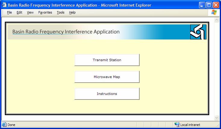
8 Application Requirements Check new tower locations for Radio frequency interference/ conflicts with existing Basin Towers Electrical engineers get FCC notification for new tower locations (latitude and longitude) Engineers conduct spatial analysis using web application - ArcGIS Server 100, 125 Mile Spatial Buffer (with bearing/azimuths) Frequency conflict values (+-10 MHz) Complete two different levels of analysis Transmission Stations Microwave Maps PDF maps produced to file documentation to the FCC
9 Key Application Design Concepts ESRI ArcGIS Server Platform Why Server? Distributable over Intranet (IIS 6.0, WS 2003,.NET 1.1) Server Based GIS (ArcGIS Server 9.1 ) Focused Spatial Analysis Operations Available Used EDN for quick turn around Application must be available to Engineers Removed bottleneck in GIS Staff Resources Interface must be simple and easy to use Key input parameters only (lat, long, frequency etc.) Map Tools (Zoom In, Zoom Out, Pan, Measure etc.) Enterprise GIS data to run spatial Analysis ArcSDE on Microsoft SQL Server Map output must be clear and easy to read

10 Key Application Design Concepts Transmit Station Input Parameters (validated on entry) Lat, Long Frequency Frequency Adjustment Site Name Azimuth 1 Azimuth 2 Creates Station Map/Report 125 Mile Buffer Highlights potential interference/conflict Export/Print Map to.pdf
11 Key Application Design Concepts Microwave Towers Input Parameters (validated on entry) Lat, Long Frequency Site Name Frequency Adjustment Creates Map/Report 100 and 125 Mile Buffer (merged if necessary) Highlights potential interference/conflict Export/Print Map to.pdf

12 Key Application Design Concepts Simple Mapping Tools Zoom In Zoom Out Pan Measure Line Distance Clear Line Toggle Site Labels On/Off
13 Application Demonstration
14 Business Process Improvements End users do not need GIS experience Runs on a central server against a GIS repository to allow for standard spatial analysis and modification of the code Creates a quick study of the new tower locations to determine if a problem exists then do detail studies/analysis Expedite conflict/interference checking process it is a great tool and she (an electric engineer) had done 25 different checks that morning. That is more than I (a GIS analyst) could do in a full day. BASIN electric
15 Lessons Learned ArcGIS Server provides for quick deployment of the application Total development time one month Code Adjustments easy to make Quick analysis and simple map products run great in ArcGIS Server Add-on Possibilities Select new tower site on screen Closest tower distances Multiple and Flexible Buffer Distances
16 Questions and Thank You!
17

18 Partnering to to Build Build Better Infrastructure
19 Partnering to to Build Build Better Infrastructure

20

21
22

23

24

25
26
Wind Power GeoPlanner. GPS Study
 Prepared on Behalf of Eight Point Wind, LLC Table of Contents 1. Introduction - 1-2. Project Overview - 1-3. Line-of-Sight Analysis - 2-4. Impact Assessment - 5-5. Contact - 5 - Comsearch Proprietary -
Wind Power GeoPlanner. Land Mobile Report - UPDATE
 Prepared on Behalf of Iberdrola Renewables, LLC December 13, 2012 Table of Contents 1. Introduction - 1-2. Summary of Results - 1-3. Impact Assessment - 3-4. Conclusions - 4-5. Recommendations & Mitigation
Wind Power GeoPlanner. Microwave Study
 Prepared on Behalf of Baron Winds LLC Table of Contents 1. Introduction - 1-2. Project Overview - 1-3. Two-Dimensional Fresnel Zone Analysis - 2-4. Conclusion - 6-5. Contact - 6 - Comsearch Proprietary
Wind Power GeoPlanner. AM and FM Radio Report
 Prepared on Behalf of Eight Point Wind, LLC April 4, 2017 Table of Contents 1. Introduction - 1-2. Summary of Results - 1-3. Impact Assessment - 5-4. Recommendations - 5-5. Contact - 5 - Comsearch Proprietary
THE LIST USABILITY PUG 2007
 THE LIST USABILITY PUG 2007 Layer/Map Management Working with many layers, maps and data sets Direction that ESRI is taking with the Geodatabase Information Model Direction that ESRI is taking with GIS
ARCGIS DESKTOP DEMO (GEOCODING, SERVICE AREAS, TABULAR & SPATIAL JOINS)
") ARCGIS DESKTOP DEMO (GEOCODING, SERVICE AREAS, TABULAR & SPATIAL JOINS) Indiana State GIS Day Conference: September 22, 2015 ASHLEY SUITER GIS Data Analyst Epidemiology Resource Center Indiana State Department
ARCGIS DESKTOP DEMO (GEOCODING, SERVICE AREAS, TABULAR & SPATIAL JOINS) Indiana State GIS Day Conference: September 22, 2015 ASHLEY SUITER GIS Data Analyst Epidemiology Resource Center Indiana State Department
Wind Power GeoPlanner. Communication Tower Study
 Prepared on Behalf of EDP Renewables January 30, 2015 Table of Contents 1. Introduction - 1-2. Summary of Results - 1-3. Discussion of Separation Distances - 4-4. Conclusions - 5-5. Contact Us - 5 - Comsearch
Wind Power GeoPlanner. AM and FM Radio Report
 Prepared on Behalf of Baron Winds LLC August 24, 2017 Table of Contents 1. Introduction - 1-2. Summary of Results - 1-3. Impact Assessment - 6-4. Recommendations - 6-5. Contact - 8 - Comsearch Proprietary
An ESRI White Paper May 2009 ArcGIS 9.3 Geocoding Technology
 An ESRI White Paper May 2009 ArcGIS 9.3 Geocoding Technology ESRI 380 New York St., Redlands, CA 92373-8100 USA TEL 909-793-2853 FAX 909-793-5953 E-MAIL info@esri.com WEB www.esri.com Copyright 2009 ESRI
Wind Power GeoPlanner. Microwave Study
 Prepared on Behalf of EDP Renewables Table of Contents 1. Introduction - 1-2. Project Overview - 1-3. Fresnel Zone Analysis - 2-4. Conclusion - 5-5. Contact - 5 - Comsearch Proprietary - 0 - 1. Introduction
GEOGRAPHIC INFORMATION SYSTEMS Lecture 22: Field Mapping with GPS
 GEOGRAPHIC INFORMATION SYSTEMS Lecture 22: Field Mapping with GPS GPS Receivers - there are many GPS receivers on the market today - some receivers are relatively inexpensive (recreational grade receivers)
Wind Power GeoPlanner. Licensed Microwave Report
 Prepared on Behalf of Environmental Design and Research September 5, 2012 Table of Contents 1. Introduction - 1-2. Summary of Results - 2-3. Tables and Figures - 4-4. Contact Us - 8 - Comsearch Proprietary
Analysis & Geoprocessing: Case Studies Problem Solving
 Analysis & Geoprocessing: Case Studies Problem Solving Shawn Marie Simpson Federal User Conference 2008 3 Overview Analysis & Geoprocessing Review What is it? How can I use it to answer questions? Case
Methods for Mapping Stormwater Infrastructure
 Methods for Mapping Stormwater Infrastructure GIS Day 2018 Rebecca Talamini Applied Geographics Project Manager Rebecca Talamini Project Manager - AppGeo rtalamini@appgeo.com 860-339-4255 Who is? Boston
GIS-Based Plan and Profile Mapping
 GIS-Based Plan and Profile Mapping ESRI International User Conference 2010 July 12-16, 2010 Maik Flanagin U.S. Army Corps of Engineers, MVN New Orleans, Louisiana maik.c.flanagin@usace.army.mil Sam Falchook
ENGINEERING REPORT CONCERNING THE EFFECTS UPON FCC LICENSED RF FACILITIES DUE TO CONSTRUCTION OF THE (Name of Project) WIND PROJECT Near (City, State)
 WIND PROJECT Near (City, State)") ENGINEERING REPORT CONCERNING THE EFFECTS UPON FCC LICENSED RF FACILITIES DUE TO CONSTRUCTION OF THE (Name of Project) WIND PROJECT Near (City, State) for (Name of Company) January 3, 2011 By: B. Benjamin
ENGINEERING REPORT CONCERNING THE EFFECTS UPON FCC LICENSED RF FACILITIES DUE TO CONSTRUCTION OF THE (Name of Project) WIND PROJECT Near (City, State) for (Name of Company) January 3, 2011 By: B. Benjamin
Wind Power GeoPlanner. Microwave Study
 Prepared on Behalf of Eight Point Wind, LLC Table of Contents 1. Introduction - 1-2. Project Overview - 1-3. Two-Dimensional Fresnel Zone Analysis - 2-4. Conclusion - 7-5. Contact - 7 - Comsearch Proprietary
A Web Application That Can Save You Money
 Esri Southwest Conference December 2-4, 2014 Santa Fe, NM A Web Application That Can Save You Money Colleen Swain, Swain GIS Services, LLC Brian Zheng, East Bay Municipal Utility District Problem Background
City of Orlando Alpha Test July 10, 2000
 City of Orlando Alpha Test July 10, 2000 Submitted by Naztec, Inc. Naztec, Inc. installed local intersection equipment and StreetWise control system under the City of Orlando s Alpha Test to replace existing
Part 9: Application Procedures and Rules for Terrestrial S-DARS Undertakings (Satellite Digital Audio Radio Service)
") Issue 2 January 2009 Spectrum Management and Telecommunications Broadcasting Procedures and Rules Part 9: Application Procedures and Rules for Terrestrial S-DARS Undertakings (Satellite Digital Audio Radio
Issue 2 January 2009 Spectrum Management and Telecommunications Broadcasting Procedures and Rules Part 9: Application Procedures and Rules for Terrestrial S-DARS Undertakings (Satellite Digital Audio Radio
TRACER. Wireless License-free Digital Microwave Radios. Easy Steps to Wireless Solutions. Experts choose ADTRAN. QUICK REFERENCE GUIDE
 TRR Wireless License-free igital Microwave Radios QUIK RRN UI 4 asy Steps to Wireless Solutions xperts choose TRN. TRR Systems Wireless License-free igital Microwave Radios TRN s TRR is a license-free
Improving Airport Planning & Development and Operations & Maintenance via Skyline 3D Software
 Improving Airport Planning & Development and Operations & Maintenance via Skyline 3D Software By David Tamir, February 2014 Skyline Software Systems has pioneered web-enabled 3D information mapping and
ZapForum Webcast The Great Debate: ESBs, Fabrics, or Something Else. How to Use Spiderphone
 ZapForum Webcast The Great Debate: ESBs, Fabrics, or Something Else May 4, 2005 Take Credit Code: ZFMAYESB 1 How to Use Spiderphone First: Turn off any pop-up blockers! If you have a question, raise your
FREQUENCY COORDINATION PROCEDURES & DATABASE MAINTENANCE RESPONSIBILITIES MANUAL
 FREQUENCY COORDINATION PROCEDURES & DATABASE MAINTENANCE RESPONSIBILITIES MANUAL July 2016 TABLE OF CONTENTS 1.0 INTRODUCTION 3 1.1 GENERAL 3 1.2 COORDINATION BETWEEN CANADIAN COMPANIES 5 1.3 TRANSBORDER
REQUEST FOR PROPOSAL. Record Drawing Production and GIS Data Capture
 REQUEST FOR PROPOSAL Record Drawing Production ADDENDUM A Questions and Answers, Attendance from Pre-Proposal Conference and Supplemental Information April 9, 2010 1. PURPOSE The purpose of this addendum
Basic SCADA Communication Design
 Gas Well De-Liquification Workshop February 28 - March 2, 2005 Basic SCADA Communication Design Jim Gardner Business Development Manager FreeWave Technologies Defining the System: 6 Key Questions Volume
Spatial Analysis with ArcGIS Pro. Krithica Kantharaj, Esri
 Spatial Analysis with ArcGIS Pro Krithica Kantharaj, Esri What is analysis? Analysis transforms raw data into information or knowledge Spatial analysis does this for geographic or spatial data Who? What?
Operator s Manual for Your Wireless Leash Guidance Trainer Series
 Operator s Manual for Your Wireless Leash Guidance Trainer Series Congratulations! The Unleashed Technology Wireless Leash Guidance Trainer Series you have purchased is a step forward in technology and
Wind Power GeoPlanner. Land Mobile & Emergency Services Report
 Prepared on Behalf of Wind LLC February 27, 2015 Wind LLC Table of Contents 1. Introduction - 1-2. Summary of Results - 2-3. Impact Assessment - 8-4. Recommendations - 8-5. Contact - 9 - Comsearch Proprietary
ArcGIS 9 Using ArcGIS StreetMap
 ArcGIS 9 Using ArcGIS StreetMap Copyright 2001 2004 ESRI All Rights Reserved. Printed in the United States of America. The information contained in this document is the exclusive property of ESRI. This
SF C-Series. 900 MHz Wireless Switch Follower/Remote Control Receiver (with On-Board 10-Amp Relays) Typical Applications
 Typical Applications") Long Range Wireless Applications 900 MHz Wireless Switch Follower/Remote Control Receiver (with On-Board 10-Amp Relays) The SF900C Series Remote Control/Switch Followers are a twoway system designed to
Long Range Wireless Applications 900 MHz Wireless Switch Follower/Remote Control Receiver (with On-Board 10-Amp Relays) The SF900C Series Remote Control/Switch Followers are a twoway system designed to
Networking Devices over White Spaces
 Networking Devices over White Spaces Ranveer Chandra Collaborators: Thomas Moscibroda, Rohan Murty, Victor Bahl Goal: Deploy Wireless Network Base Station (BS) Good throughput for all nodes Avoid interfering
Canada C3 Expedition
 Canada C3 Expedition CG3EXP, WSPR, Canada C3 Expedition Award Presented to the Kingston Amateur Radio Club by Cliff Chip Chapman, VA3KGB 5 September 2017 Canada C3 The Polar Prince Canada C3 A Canada 150
Attachment C to Modification # 6 to VA HSMM. Schedule of Fees
 Task A. Perform radio asset inventory, needs assessment, and project expected growth. B. Document existing radio frequency authorizations. Devise a frequency reuse strategy. Determine the capacity of the
Using the ModelBuilder of ArcGIS 9 for Landscape Modeling
 Using the ModelBuilder of ArcGIS 9 for Landscape Modeling Jochen MANEGOLD, ESRI-Germany Geoprocessing in GIS A geographic information system (GIS) provides a framework to support planning tasks and decisions,
New Upgrade Choices: Aligning Your Strategy to Microsoft
 New Upgrade Choices: Aligning Your Strategy to Microsoft Introduction David Kaupp Jon Long Senior Upgrade Advisor ArcherPoint Upgrades Director ArcherPoint Upgrades Session Objectives What will you learn
Upper 700 MHz A Block Spectrum
 Upper 700 MHz A Block Spectrum A Wireless Solution for Utilities & Critical Infrastructure Industry Access Spectrum, LLC Q3 2015 Upper 700 MHz A Block 2x1 MHz paired (2 MHz total) Block 52 Major Economic
Reducing deployment cost and time with Yagi and parabolic grid antennas
 July 212, issue 1.2. 4RF White Paper Reducing deployment cost and time with Yagi and parabolic grid antennas Contents 1. Overview 2 2. Reduced weight and wind force 3 3. Reduced operational cost 7 Page
User Manual Information and Product Description. of the. Flap Key Family BOSCH. with Chevy, GMC and GM Logo
 User Manual Information and Product Description of the Flap Key Family BOSCH with Chevy, GMC and GM Logo Page 1 of 7 General Description of the RF transmitter: The RF remote control system consists of
Geocoding Techniques and Options for US and International Locations. Thomas Oaks Tosia Shall
 Geocoding Techniques and Options for US and International Locations Thomas Oaks Tosia Shall Agenda Geocoding Overview and Requirements Geocoding in Desktop Geocoding with a Service What is Geocoding? A
Upper 700 MHz A Block Spectrum
 Upper 700 MHz A Block Spectrum A Wireless Solution for Utilities & Critical Infrastructure Industry Access Spectrum, LLC Q3 2015 RED: Sold/Under Contract PGE NWE GRE NWE SRP GREY: Access Spectrum Geography
EverBlu. Wireless fixed data collection system
 Solution EverBlu Wireless fixed data collection system > Automatic daily meter reads > Graphical data analysis > Reliable self-healing wireless mesh network > Suitable for urban, suburban and rural environments
An Approach to Integrating Modeling & Simulation Interoperability
 An Approach to Integrating Modeling & Simulation Interoperability Brian Spaulding Jorge Morales MÄK Technologies 68 Moulton Street Cambridge, MA 02138 bspaulding@mak.com, jmorales@mak.com ABSTRACT: Distributed
Capability Statement. Brisbane. Dalby. Mackay. Moranbah
 Capability Statement Brisbane Dalby Mackay Moranbah Who we are RCS Telecommunications was created in 2013 through the merger of Queensland Communications and Networking (QCN) and Radio Communications Solutions
GIS and Remote Sensing BIO8014. Data acquisition
 GIS and Remote Sensing BIO8014 Data acquisition Introduction Data can be manually created Data can be obtained from a wide range of providers both free and at cost Acquisition is key and must be accounted
SALE OF UPPER 700 MHZ A BLOCK SPECTRUM
 SALE OF UPPER 700 MHZ A BLOCK SPECTRUM A Wireless Solution for Utilities and Critical Infrastructure Enterprises John Vislosky, Access Spectrum, LLC Q2 s2015 UPPER 700 MHZ A BLOCK The Upper 700 MHz A Block
Esri and Autodesk What s Next?
 AN ESRI VISION PAPER JANUARY 2018 Esri and Autodesk What s Next? Copyright 2018 Esri All rights reserved. Printed in the United States of America. The information contained in this document is the exclusive
Licensed vs Unlicensed Microwave Technology. Overview of Wireless John Dolmetsch
 Licensed vs Unlicensed Microwave Technology Wireless Topics Common licensed and unlicensed frequencies Frequencies and Ranges Indoor Wireless Technologies Licensed vs. Unlicensed Frequencies Mobile Applications
Qt Developing ArcGIS Runtime Applications. Eric
 Qt Developing ArcGIS Runtime Applications Eric Bader @ECBader Agenda Getting Started Creating the Map Geocoding and Routing Geoprocessing Message Processing Working Offline The Next Release What s Coming
Wyoming s Statewide Public-Safety Interoperable Radio Communications System WyoLink Frequently Asked Questions (FAQ)
") Wyoming s Statewide Public-Safety Interoperable Radio Communications System WyoLink Frequently Asked Questions (FAQ) Goals... 2 1. What is WyoLink supposed to accomplish?... 2 2. Who will oversee WyoLink
Wyoming s Statewide Public-Safety Interoperable Radio Communications System WyoLink Frequently Asked Questions (FAQ) Goals... 2 1. What is WyoLink supposed to accomplish?... 2 2. Who will oversee WyoLink
EDUCATION GIS CONFERENCE Geoprocessing with ArcGIS Pro. Rudy Prosser GISP CTT+ Instructor, Esri
 EDUCATION GIS CONFERENCE Geoprocessing with ArcGIS Pro Rudy Prosser GISP CTT+ Instructor, Esri Maintenance What is geoprocessing? Geoprocessing is - a framework and set of tools for processing geographic
PALMETTO 800 History Project Cost
 PALMETTO 800 South Carolina has implemented the largest statewide emergency communications radio system in the nation. With over twenty thousand users, the system is available to federal, state, and local
Super Switch Indoor Wireless Remote Control Wall Outlets
 Super Switch Indoor Wireless Remote Control Wall Outlets The Remote Control for Living Room, Kitchen & Bedroom Lights, Lamps, Fans and More Item/Art. 770742 Model #: SSW2-3-3322 Set of (3) Indoor Outlets
Presentation Skills Workshop
 Presentation Skills Workshop Rudy Prosser GISP CTT+ Instructor, Esri Keera Morrish CTT+ Instructor, Esri No interaction Left the session Confident Engaged Read from the slide Waste of time Dynamic Interested
HFCC 2018 Bratislava Product Launch: Low Power Solid-State Shortwave
 HFCC 2018 Bratislava Product Launch: Low Power Solid-State Shortwave 27.08.2018 1 Our Mission Science MedTech Ampegon designs and delivers high power systems for world-class research facilities. «We offer
CIC SASKPOWER SMART METER REVIEW
 CIC SASKPOWER SMART METER REVIEW TERMS OF REFERENCE DATE)AUGUST 15, 2014 1. PURPOSE SMART METER REVIEW Terms of Reference The Government of Saskatchewan has requested that Crown Investments Corporation
Simulcast Radio Network Design. Jay M. Jacobsmeyer, P.E. Pericle Communications Co Vindicator Drive, Suite 100 Colorado Springs, CO 80919
 Simulcast Radio Network Design Jay M. Jacobsmeyer, P.E. Pericle Communications Co. 1910 Vindicator Drive, Suite 100 Colorado Springs, CO 80919 Outline Company Overview Background Information Needs Analysis
Geocoding An Introduction
 2013 Esri International User Conference July 8 12, 2013 San Diego, California Technical Workshop Geocoding An Introduction Miriam Schmidts Agatha Wong Esri UC2013. Technical Workshop. Agenda What is geocoding?
Communicator II WIRELESS DATA TRANSCEIVER
 Communicator II WIRELESS DATA TRANSCEIVER C O M M U N I C A T O R I I The Communicator II is a high performance wireless data transceiver designed for industrial serial and serial to IP networks. The Communicator
Lesson Plan 1 Introduction to Google Earth for Middle and High School. A Google Earth Introduction to Remote Sensing
 A Google Earth Introduction to Remote Sensing Image an image is a representation of reality. It can be a sketch, a painting, a photograph, or some other graphic representation such as satellite data. Satellites
Modeling & Simulation Capability for Consequence Management
 Modeling & Simulation Capability for Consequence Management Vic Baker Advanced Systems Technologies Mid-Atlantic Technology, Research & Innovation Center (MATRIC) Morgantown, WV, USA vic.baker@matricresearch.com
MOE125 Offshore Well Construction
 MOE125 Offshore Well Construction H.H. Sheikh Sultan Tower (0) Floor Corniche Street Abu Dhabi U.A.E www.ictd.ae ictd@ictd.ae Course Introduction: This five-day course provides a fundamental understanding
Building Java Apps with ArcGIS Runtime SDK
 Building Java Apps with ArcGIS Runtime SDK Vijay Gandhi, Elise Acheson, Eric Bader Demo Source code: https://github.com/esri/arcgis-runtime-samples-java/tree/master/devsummit-2014 Video Recording: http://video.esri.com
Minimum Drawing & Electronic Submittal Requirements For Record Drawings /As-Builts
 Minimum Drawing & Electronic Submittal Requirements For Record Drawings /As-Builts PUBLIC WORKS ENGINEERING DEPARTMENT Revised: February 1, 2017 MINIMUM DRAWING REQUIREMENTS A. GENERAL PLAN REQUIREMENTS:
I m Dreaming of a Wireless Building
 I m Dreaming of a Wireless Building AIA Convention presentation June 11, 2004 Presented by Elert & Associates Frank Dolejsi Minnesota Bureau of Criminal Apprehension (BCA) Mark Hoekstra Skyline Exhibits
RADARSAT-2/RCM Synthetic Aperture Radar data exploitation for military geomatics via ArcGIS
 RADARSAT-2/RCM Synthetic Aperture Radar data exploitation for military geomatics via ArcGIS Presented by: Greg Barrie, Defence Scientist, DRDC Ottawa October 17, 2018 Defence R&D Canada (DRDC) What we
Blue Point Engineering
 Overview Blue Point Instruction Board 2-CH Boards, Terminal Block and Ribbon Cable I Type: RF Radio (315 MHz) 1-2 Channels (FCC Part 15 Compliant Components). Operating Voltage: 6-15 VDC @ 1 Amp (Wall
GPS and GSM Based Transmission Line Monitoring System with Fault Detection Introduction:
 GPS and GSM Based Transmission Line Monitoring System with Fault Detection Introduction: Electricity is an extremely handy and useful form of energy. It plays an ever growing role in our modern industrialized
O NEILL SUBSTATION STAGE 02 CALIFORNIA
 SECTION C DESCRIPTION/SPECIFICATIONS Spec. No. 769 O NEILL SUBSTATION STAGE 02 CALIFORNIA O NEILL SUBSTATION STAGE 02 PROJECT DRAWINGS A. GENERAL: CONSTRUCTION STANDARD DRAWINGS: A complete set of standard
SECTION GEOGRAPHIC INFORMATION SYSTEM (GIS)
") PART 1 - GENERAL 1.1 DESCRIPTION SECTION 11 83 01 A. Provide all labor, materials, manpower, tools and equipment required to furnish, install, activate and test a new Geographic Information System (GIS).
PART 1 - GENERAL 1.1 DESCRIPTION SECTION 11 83 01 A. Provide all labor, materials, manpower, tools and equipment required to furnish, install, activate and test a new Geographic Information System (GIS).
Small Cell Infrastructure in Denver
 September 2017 Small Cell Infrastructure in Denver The City and County of Denver is receiving growing numbers of requests from wireless providers and wireless infrastructure companies to construct small
ArcGIS Runtime: Analysis. Lucas Danzinger Mark Baird Mike Branscomb
 ArcGIS Runtime: Analysis Lucas Danzinger Mark Baird Mike Branscomb ArcGIS Runtime session tracks at DevSummit 2018 ArcGIS Runtime SDKs share a common core, architecture and design Functional sessions promote
Lesson 3: Working with Landsat Data
 Lesson 3: Working with Landsat Data Lesson Description The Landsat Program is the longest-running and most extensive collection of satellite imagery for Earth. These datasets are global in scale, continuously
EMERGENCY COMMUNICATIONS
 EMERGENCY COMMUNICATIONS FY2004-2010 1. BACKGROUND ISSUES The Emergency Communications element of the capital plan is comprised of three projects concerning emergency radio communications, computer aided
Location, Location, Location
 Location, Location, Location Larry Rudolph 1 Outline Positioning Technology GPS and others Location Specifiers Privacy Issues Universal Location On earth, we need three piece of information: latitude,
FREQUENTLY ASKED QUESTIONS ABOUT ALLOWABLE USES OF 911 FEES Updated January, 2018
 FREQUENTLY ASKED QUESTIONS ABOUT ALLOWABLE USES OF 911 FEES Updated January, 2018 Statute governing the use of 911 fees received by PSAPs from the LCPA: K.S.A. 12-5375(a) The proceeds of the 911 fees imposed
Technical publication. Path alignment and cross polarization procedure for parabolic microwave antennas
 Technical publication Path alignment and cross polarization procedure for parabolic microwave antennas Contents 1.0 Introduction 3 2.0 Path alignment procedure 3 2.1 Setting azimuth marker 3 2.2 Test equipment
TRAINING BULLETIN. EFFECTIVE DATE: 05/06 DOC NO: TB198 CROSS REF: Communications Checklists
 INTRODUCTION Communications Support 131 (CS131) is an important asset of the District and plays a significant role in the county and region. The unit has many communications assets, including radios on
SATELLITE RADIO/TELEPHONE
 A Unique and Powerful Communications System NETWORK INNOVATIONS SATELLITE RADIO/TELEPHONE (FORMERLY SKYTERRA, MSV, LIGHT SQUARED ) Secure Communications 1. The network employs the IMBE (Improved Multi-Band
Accelerator management with
 Accelerator management with Web-based based GIS A.Yamashita,Y.Ishizawa, M.Takeuchi and T.Ohata SPring-8, Japan PCaPAC 2006@JLab Outline Google map What is GIS? What we want to with GIS for SPring-8 MapServer
TAP 6 Demo Quick Tour
 TAP 6 Demo Quick Tour Sales Contact: Curt Alway P.O. Box 7205 Charlottesville, VA 22906 Voice: 303-344-5486, Ext 1 Fax: 303-265-9399 Email: sales@softwright.com Technical Contact: Todd Summers, Ph.D. P.O.
SF C-Series. 900 MHz Wireless Switch Follower/Remote Control Receiver (with On-Board 10-Amp Relays) Typical Applications
 Typical Applications") Long Range Wireless Applications 900 MHz Wireless Switch Follower/Remote Control Receiver (with On-Board 10-Amp Relays) The SF900C Series Remote Control/Switch Followers are a twoway system designed to
Long Range Wireless Applications 900 MHz Wireless Switch Follower/Remote Control Receiver (with On-Board 10-Amp Relays) The SF900C Series Remote Control/Switch Followers are a twoway system designed to
TRBOnet Guard Tour Configuration and Operation Guide
 TRBOnet Guard Tour and Operation Guide Version 5.0 World HQ Neocom Software 8th Line 29, Vasilyevsky Island St. Petersburg, 199004, Russia US Office Neocom Software 15200 Jog Road, Suite 202 Delray Beach,
Minimal form factor Multi system MIMO technology ANTENNA SITE SOLUTION
 Minimal form factor Multi system MIMO technology ANTENNA SITE SOLUTION Optimal. Multiple. MIMO Given the prodigious increase in the applications that utilize wireless local area network technology and
TRBOnet Enterprise/PLUS
 TRBOnet Enterprise/PLUS Guard Tour User Guide Version 5.2 World HQ Neocom Software 8th Line 29, Vasilyevsky Island St. Petersburg, 199004, Russia US Office Neocom Software 15200 Jog Road, Suite 202 Delray
RFI & Motorola. Program Partnership
 RFI & Motorola Program Partnership RFI Technology Solutions. Your Proven Partner. We understand that choosing your antenna systems is not something that is a game of chance. Transitioning to a different
Map Direct Lite. Contents. Quick Start Guide: Drawing 11/05/2015
 Map Direct Lite Quick Start Guide: Drawing 11/05/2015 Contents Quick Start Guide: Drawing... 1 Drawing, Measuring and Analyzing in Map Direct Lite.... 2 Measure Distance and Area.... 3 Place the Map Marker
BreezeACCESS VL. Beyond the Non Line of Sight
 BreezeACCESS VL Beyond the Non Line of Sight July 2003 Introduction One of the key challenges of Access deployments is the coverage. Operators providing last mile Broadband Wireless Access (BWA) solution
An Automated Operational System for Collating Field and Satellite Data for Grassland Curing Assessment. Presented by: Alex Chen and Danielle Martin
 An Automated Operational System for Collating Field and Satellite Data for Grassland Curing Assessment Presented by: Alex Chen and Danielle Martin Outline Rationale Background Automated Web-Based System
ArcGIS Runtime SDK for Java: Building Applications. Eric
 ArcGIS Runtime SDK for Java: Building Applications Eric Bader @ECBader Agenda ArcGIS Runtime and the SDK for Java How to build / Functionality - Maps, Layers and Visualization - Geometry Engine - Routing
Canopy Backhaul Portfolio. Motorola s flexible MOTOwi4 backhaul solutions
 Canopy Backhaul Portfolio Motorola s flexible MOTOwi4 backhaul solutions MOTOwi4 Backhaul Solutions Engineered for Simple-to-Complex Applications in Challenging Environments With the introduction of its
Rulemaking Hearing Rules of the Tennessee Department of Health Bureau of Health Licensure and Regulation Division of Emergency Medical Services
 Rulemaking Hearing Rules of the Tennessee Department of Health Bureau of Health Licensure and Regulation Division of Emergency Medical Services Chapter 1200-12-01 General Rules Amendments of Rules Subparagraph
Designing a WebGIS architecture for aviation impact assessment
 UNCLASSIFIED Nationaal Lucht- en Ruimtevaartlaboratorium National Aerospace Laboratory NLR Executive summary Designing a WebGIS architecture for aviation impact assessment Problem area In aviation a lot
3. GPS receiver instruction cards GPS receivers
 Subject: GPS (& how its applications with Agriculture) Date: June 10, 2010 Lesson Title: Where exactly are we? Grade Level: Upper Elementary/Middle School Time period: 60-90 minutes Lesson Objectives:
Unit 1 - Surveying the Landscape
 Creative Coding through Games and Apps Unit 1 - Surveying the Landscape Instructional Day: Unit 1, Lesson 4 Topic Description In this lesson, students make connections between the code for a game and the
DESCRIPTION OF INTENDED SINGLE SOURCE PURCHASE (PUR 7776)
") DESCRIPTION OF INTENDED SINGLE SOURCE PURCHASE (PUR 7776) AGENCY Department of Management Services TITLE Mutual Aid Communication Microwave Short description of the commodity or service desired: Microwave
DESCRIPTION OF INTENDED SINGLE SOURCE PURCHASE (PUR 7776) AGENCY Department of Management Services TITLE Mutual Aid Communication Microwave Short description of the commodity or service desired: Microwave
University of Kansas. The University of Kansas Libraries
 University of Kansas The University of Kansas Libraries Finding Common Ground The University of Kansas Libraries Approaches to building Digital Libraries from Strategic to Tech Cool Deborah Ludwig, Assistant
Geospatial Keynote Nordic Civil konference I Vejle Bentley Systems, Incorporated 2016 Bentley Systems, Incorporated
 Geospatial Keynote Nordic Civil konference 07.11.2016 I Vejle 1 WWW.BENTLEY.COM 2016 Bentley Systems, Incorporated 2016 Bentley Systems, Incorporated Introduction Johannes Klick Senior Support Manager
Director General Engineering, Planning and Standards Branch (JETN, Room 1943B) Industry Canada 235 Queen Street, Ottawa, Ontario, K1A 0H5
 Industry Canada 235 Queen Street, Ottawa, Ontario, K1A 0H5") 340 Albert St Suite 1300 Ottawa, ON K1R 7Y6 BY EMAIL to Spectrum.engineering@ic.gc.ca Director General Engineering, Planning and Standards Branch (JETN, Room 1943B) Industry Canada 235 Queen Street, Ottawa,
340 Albert St Suite 1300 Ottawa, ON K1R 7Y6 BY EMAIL to Spectrum.engineering@ic.gc.ca Director General Engineering, Planning and Standards Branch (JETN, Room 1943B) Industry Canada 235 Queen Street, Ottawa,
Summary of All Costs Table
 Page 1 of 13 800 MHz Reconfiguration (RFPF) Form Sample: Large and Medium System Please refer to RFPF Process section of the Resources by Category section of the TA website (http://www.800ta.org/content/resources/processes.asp),