Geocoding An Introduction
|
|
|
- Suzan Sullivan
- 5 years ago
- Views:
Transcription


1 2013 Esri International User Conference July 8 12, 2013 San Diego, California Technical Workshop Geocoding An Introduction Miriam Schmidts Agatha Wong Esri UC2013. Technical Workshop.
2 Agenda What is geocoding? Overall workflow of geocoding Geocoding with ArcGIS Online Geocoding with ArcGIS
3 What is Geocoding? Geocoding: A GIS operation to transform a description of a location such as a pair of coordinates, an address, or a name of a place to a location on a map.
4 What is a locator / geocode service? Table of Addresses Geocode services Address Locator Geocoded features
5 Address Locators in ArcGIS Defines the process for geocoding Stored in a File folder or geodatabase Can be published as a service


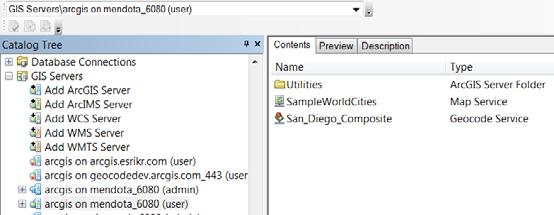
6 Ways to find geocode services for geocoding ArcGIS Online Geocode Services StreetMap Premium Products from Esri Geocoding can be done with locators or geocode services from various sources Users locators shared at Arcgis.com Build your own locators with ArcGIS Desktop


7 Demo Finding an address Esri UC2013. Technical Workshop.
8 I am an analyst working in an insurance company, please just show me how to geocode my addresses.


9 Geocoding addresses Address Tables Geocode Service / Locator Geocoded Result Geocode IIS Esri UC2013. Technical Workshop.


10 Ways to do Geocoding Reverse Batch Interactive
11 Demo Geocoding with ArcGIS Online Esri UC2013. Technical Workshop.

12 Geocoding with ArcGIS.com ArcGIS Online

13 Geocoding with World service ArcMap
14 I am a GIS specialist working in the county government, please show me how to use my data to create address locators or services.


15 Workflow of ge ocoding ArcGIS for Desktop ArcGIS for Server Reference features Create locator / service Address Tables Geocode Geocode Service / Locator Geocoded Result IIS Esri UC2013. Technical Workshop.
16 Geocoding with a locator Build or obtain reference data Determine address locator style Build an address locator Locate addresses
17 Reference Data Many sources - StreetMap data - Government data - Data vendors - Data shared on ArcGIS.com

18 Geocoding Work Flow Build or obtain reference data Determine address locator style Build an address locator Locate addresses

19 What is an Address Locator Style Template containing geocoding properties Choose style based on properties of: - Address data: address information to geocode - Reference data: geometry and attribute values Locator styles can be customized to support international addresses


20 Locator Style Example US Address - Single House Reference Data = Points or Polygons
21 Geocoding Work Flow Build or obtain reference data Determine address locator style Build an address locator Locate addresses
22 Demo Create an address locator Geocode addresses Esri UC2013. Technical Workshop.
23 Geocoding Work Flow Build or obtain reference data Determine address locator style Build an address locator Locate addresses


24 Composite Locator Combines multiple locators - Geocode against multiple datasets - Cascade/Fallback geocoding - Spatially disjointed datasets
25 Demo Create a composite locator Esri UC2013. Technical Workshop.

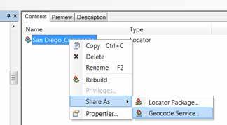
26 Publishing locator as a geocode service


27 Recap ArcGIS for Desktop ArcGIS for Server Reference features Create locator / service Address Tables Geocode Geocode Service / Locator Geocoded Result IIS Esri UC2013. Technical Workshop.
28 Summary Geocoding with ArcGIS 10.2 What is geocoding? Geocoding work flow Table of Addresses Geocode services Address Locator Geocoded features

29 Resources and References Esri Resource Centers ding
30 Additional Geocoding Presentations Esri Showcase Software Island Demo Theater Tuesday Geocoding with ArcGIS.com (3:30-4:00 PM) Hall C, Online GIS Wednesday Geocoding Services (12 PM 1:30 PM) Hall C, Online GIS What is new in Geocoding (3:30-4:00 PM) Hall F, Room 1 Thursday What is new in Geocoding (3:30-4:00 PM) Hall G, Room 2 Visit the Spatial Analysis Island in the Exhibit Hall
31 Thank you for attending Have fun at UC2013 Open for Questions Please fill out the evaluation: First Offering ID: 1176 Second Offering ID: 1293


32
Network Analyst: Automating Workflows with Geoprocessing
 Esri International User Conference San Diego, California Technical Workshops July 25, 2012 Network Analyst: Automating Workflows with Geoprocessing Deelesh Mandloi Patrick Stevens Introductions Who are
Geocoding Techniques and Options for US and International Locations. Thomas Oaks Tosia Shall
 Geocoding Techniques and Options for US and International Locations Thomas Oaks Tosia Shall Agenda Geocoding Overview and Requirements Geocoding in Desktop Geocoding with a Service What is Geocoding? A
ModelBuilder Getting Started
 2013 Esri International User Conference July 8 12, 2013 San Diego, California Technical Workshop ModelBuilder Getting Started Matt Kennedy Esri UC2013. Technical Workshop. Agenda Geoprocessing overview
ARCGIS DESKTOP DEMO (GEOCODING, SERVICE AREAS, TABULAR & SPATIAL JOINS)
") ARCGIS DESKTOP DEMO (GEOCODING, SERVICE AREAS, TABULAR & SPATIAL JOINS) Indiana State GIS Day Conference: September 22, 2015 ASHLEY SUITER GIS Data Analyst Epidemiology Resource Center Indiana State Department
ARCGIS DESKTOP DEMO (GEOCODING, SERVICE AREAS, TABULAR & SPATIAL JOINS) Indiana State GIS Day Conference: September 22, 2015 ASHLEY SUITER GIS Data Analyst Epidemiology Resource Center Indiana State Department
ArcGIS Online Content
 Esri International User Conference San Diego, California Technical Workshops July 25, 2012 ArcGIS Online Content Deane Kensok Sarah Osborne Today s Agenda Overview Esri Content Portfolio - What s Available,
Analysis and Geoprocessing Sessions and Demo Theater Presentations
 Esri User Conference 2018 Analysis and Geoprocessing Sessions and Demo Theater Presentations TUESDAY 7/10 -------------------------------------------------------------------------------------------------------------------------------------------
Creating Geoprocessing Services
 Esri International User Conference San Diego, California Technical Workshops July 25, 2012 Creating Geoprocessing Services Kevin Hibma, Scott Murray Analysis and Geoprocessing Resource Center Quick Links:
Geocoding with ArcGIS FedGIS 2017 (2/14/2017)
") Geocoding with ArcGIS FedGIS 2017 (2/14/2017) Michael Rink, Esri Nick Patel, Esri Agenda Introduction Building a Robust Global Geocoding Experience Overview of Esri s Geocoding products Road Ahead Demo
Geocoding with ArcGIS FedGIS 2017 (2/14/2017) Michael Rink, Esri Nick Patel, Esri Agenda Introduction Building a Robust Global Geocoding Experience Overview of Esri s Geocoding products Road Ahead Demo
Geocoding Techniques and Options for US and International Locations. Brady Hoak, Tosia Shall
 Geocoding Techniques and Options for US and International Locations Brady Hoak, Tosia Shall Agenda What is geocoding? Requirements for Geocoding Preparing Your Data Selecting a Locator Geocoding Process
Presentation Skills Workshop
 Presentation Skills Workshop Rudy Prosser GISP CTT+ Instructor, Esri Keera Morrish CTT+ Instructor, Esri No interaction Left the session Confident Engaged Read from the slide Waste of time Dynamic Interested
Upgrading Common Workflows from 10.2.x to 100.x with ArcGIS Runtime SDK for.net. Melanie Whalen & Lauren Boyd
 Upgrading Common Workflows from 10.2.x to 100.x with ArcGIS Runtime SDK for.net Melanie Whalen & Lauren Boyd Agenda Architectural Overview Maps Editing Analysis Resources Q&A Architectural Overview Architecture:
Working with Geocoding APIs
 Working with Geocoding APIs Sergey Ivanenko Agatha Wong ESRI Developer Summit 2008 1 Outline Overview of Geocoding and ArcObjects Geocoding APIs Geocoding with Desktop and Engine Simple geocoding (single
Esri UC 2014 Technical Workshop
 Introduction to Parcel Fabric Amir Plans Parcels Control 1 Points 1-1 Line Points - Lines Editing and Maintaining Parcels using Deed Drafter and ArcGIS Desktop What is a parcel fabric? Dataset of related
Analysis & Geoprocessing: Case Studies Problem Solving
 Analysis & Geoprocessing: Case Studies Problem Solving Shawn Marie Simpson Federal User Conference 2008 3 Overview Analysis & Geoprocessing Review What is it? How can I use it to answer questions? Case
ArcGIS Geocoding What s New and the Road Ahead. Jeff Rogers Brad Niemand
 ArcGIS Geocoding What s New and the Road Ahead Jeff Rogers Brad Niemand Agenda Overview - ArcGIS Platform Geocoding - ArcGIS Geocoding Solutions What s New - On-Premises Geocoding Solutions - Desktop Geocoding
ArcGIS Pro: What s New in Analysis
 Federal GIS Conference February 9 10, 2015 Washington, DC ArcGIS Pro: What s New in Analysis James Sullivan What is analysis? Analysis transforms raw data into information or knowledge. Spatial analysis
Geocoding and Address Matching
 LAB PREP: Geocoding and Address Matching Environmental, Earth, & Ocean Science 381 -Spring 2015 - Geocoding The process by which spatial locations are determined using coordinate locations specified in
How to put the Image Services in the Living Atlas to Work in Your GIS. Charlie Frye, Chief Cartographer Esri, Redlands
 How to put the Image Services in the Living Atlas to Work in Your GIS Charlie Frye, Chief Cartographer Esri, Redlands Image Services in the Living Atlas of the World Let s have a look: https://livingatlas.arcgis.com
Qt Developing ArcGIS Runtime Applications. Eric
 Qt Developing ArcGIS Runtime Applications Eric Bader @ECBader Agenda Getting Started Creating the Map Geocoding and Routing Geoprocessing Message Processing Working Offline The Next Release What s Coming
ArcGIS 9 Using ArcGIS StreetMap
 ArcGIS 9 Using ArcGIS StreetMap Copyright 2001 2004 ESRI All Rights Reserved. Printed in the United States of America. The information contained in this document is the exclusive property of ESRI. This
Chapter 10. What is geocoding?
 Chapter 10 Geocoding 10-1 Copyright McGraw-Hill Education. Permission required for reproduction or display. What is geocoding? The process of assigning a location, usually in the form of coordinate values
UNIGIS University of Salzburg. Module: ArcGIS for Server Lesson: Online Spatial analysis UNIGIS
 1 Upon the completion of this presentation you should be able to: Describe the geoprocessing service capabilities Define supported data types input and output of geoprocessing service Configure a geoprocessing
Using Imagery for Intelligence Analysis. Jim Michel Renee Bernstein
 Using Imagery for Intelligence Analysis Jim Michel Renee Bernstein Deriving Value from GIS and Imagery Capabilities Evolved Along Separate but Parallel Paths GIS Imagery brings value Imagery Contextual
AGENDA. Effective Geodatabase Management. Presentation Title. Using Automation. Mohsen Kamal. Name of Speaker Company Name
 AGENDA Effective Geodatabase Management Presentation Title Using Automation Mohsen Kamal Name of Speaker Company Name Agenda Introducing the geodatabase What is a Schema? Schema Creation Options Geoprocessing
Sharing Oblique and Oriented Imagery. Cody Benkelman Cristelle D Souza UC2018
 Sharing Oblique and Oriented Imagery Cody Benkelman Cristelle D Souza UC2018 Image Orientation Image Orientation Mosaic Dataset Image Orientation Oriented Imagery Oblique Imagery Oblique imagery modes
ArcGIS Pro: Tips & Tricks
 ArcGIS Pro: Tips & Tricks James Sullivan Solution Engineer Agenda Project Structure/Set Up Data Visualization/Map Authoring Data/Map Exploration Geoprocessing Editing Layouts Sharing Working with the Ribbon
An ESRI White Paper May 2009 ArcGIS 9.3 Geocoding Technology
 An ESRI White Paper May 2009 ArcGIS 9.3 Geocoding Technology ESRI 380 New York St., Redlands, CA 92373-8100 USA TEL 909-793-2853 FAX 909-793-5953 E-MAIL info@esri.com WEB www.esri.com Copyright 2009 ESRI
Building Java Apps with ArcGIS Runtime SDK
 Building Java Apps with ArcGIS Runtime SDK Vijay Gandhi, Elise Acheson, Eric Bader Demo Source code: https://github.com/esri/arcgis-runtime-samples-java/tree/master/devsummit-2014 Video Recording: http://video.esri.com
Geocoding Techniques and Options for US and International Locations
 Federal GIS Conference February 9 10, 2015 Washington, DC Geocoding Techniques and Options for US and International Locations Tosia Shall Esri, Washington, DC James Tedrick Esri, Washington, DC Chris Sheldrick
ArcGIS Online: World Geocoding. Bruce Harold, Esri
 ArcGIS Online: World Geocoding Bruce Harold, Esri bharold@esri.com Nick Patel, Esri npatel@esri.com Agenda Introduction Benefits of Esri World Geocoding Overview of Esri s World Geocoding products What
Using the ModelBuilder of ArcGIS 9 for Landscape Modeling
 Using the ModelBuilder of ArcGIS 9 for Landscape Modeling Jochen MANEGOLD, ESRI-Germany Geoprocessing in GIS A geographic information system (GIS) provides a framework to support planning tasks and decisions,
Lecture 8 Geocoding. Dr. Zhang Spring, 2017
 Lecture 8 Geocoding Dr. Zhang Spring, 2017 Model of the course Using and making maps Navigating GIS maps Map design Working with spatial data Geoprocessing Spatial data infrastructure Digitizing File geodatabases
Geocoding Techniques and Options for US and International Locations
 Federal GIS Conference 2014 February 10 11, 2014 Washington DC Geocoding Techniques and Options for US and International Locations Tosia Shall, Esri Doug Geverdt, Census Chuck Whittington, Census Types
Copyright The McGraw-Hill Companies, Inc. Permission required for reproduction or display.
 Chapter 16. GEOCODING AND DYNAMIC SEGMENTATION 16.1 Geocoding 16.1.1 Geocoding Reference Database 16.1.2 The Address Matching Process 16.1.3 Address Matching Options Box 16.1 Scoring System for Geocoding
Public Safety Geocoding Using ArcGIS Online and HERE Data
 Public Safety Geocoding Using ArcGIS Online and HERE Data I. Knowledge, Skills, and Abilities (KSAs) Supported This training module aids in the development of several KSAs that are fundamental to using
Packaging Projects, Maps and Layers. Shilpi Jain Melanie Summers
 Packaging Projects, Maps and Layers Shilpi Jain Melanie Summers What can be packaged Layer Map Project Layer package (.lypkx) Tile package (.tpk) Scene layer package (.slpk) Map package (.mpkx) Mobile
White paper brief IdahoView Imagery Services: LISA 1 Technical Report no. 2 Setup and Use Tutorial
 White paper brief IdahoView Imagery Services: LISA 1 Technical Report no. 2 Setup and Use Tutorial Keith T. Weber, GISP, GIS Director, Idaho State University, 921 S. 8th Ave., stop 8104, Pocatello, ID
Lab Assignment 5 Geoprocessing Service. Due Date: 01/24/2014
 Lab Assignment 5 Geoprocessing Service Due Date: 01/24/2014 Overview Geoprocessing is one of the original purposes or functions when GIS was invented. It provides tools and a framework for performing analysis
ArcGIS Runtime: Analysis. Lucas Danzinger Mark Baird Mike Branscomb
 ArcGIS Runtime: Analysis Lucas Danzinger Mark Baird Mike Branscomb ArcGIS Runtime session tracks at DevSummit 2018 ArcGIS Runtime SDKs share a common core, architecture and design Functional sessions promote
THE LIST USABILITY PUG 2007
 THE LIST USABILITY PUG 2007 Layer/Map Management Working with many layers, maps and data sets Direction that ESRI is taking with the Geodatabase Information Model Direction that ESRI is taking with GIS
Spatial Analysis with ArcGIS Pro. Krithica Kantharaj, Esri
 Spatial Analysis with ArcGIS Pro Krithica Kantharaj, Esri What is analysis? Analysis transforms raw data into information or knowledge Spatial analysis does this for geographic or spatial data Who? What?
VGIN Geocoding Service
 VGIN Geocoding Service What is Geocoding? Geocoding is the process of assigning geographic coordinates (e.g., latitude and longitude) to data records such as street addresses. With geographic coordinates,
Provides the data analysis, management and
 Leveraging g the Geoprocessing Framework in ArcGIS Engine in.net (Best Practices) Jason Pardy Corey Tucker UC 2006 Tech Session 1 Workshop Outline What is Geoprocessing Accessing and Running Geoprocessing
Using Geoprocessing Services with ArcGIS Web Mapping APIs
 Using Geoprocessing Services with ArcGIS Web Mapping APIs Monica Joseph, Scott Murray Please fill session survey. What is a Geoprocessing Service? A geoprocessing service is a set of geoprocessing tools
Managing Imagery Using ArcGIS
 Managing Imagery Using ArcGIS Copyright 2010-2011 Esri All rights reserved. Course version 1.2. Version release date June 2011. Printed in the United States of America. The information contained in this
ArcGIS Runtime SDK for Java: Building Applications. Eric
 ArcGIS Runtime SDK for Java: Building Applications Eric Bader @ECBader Agenda ArcGIS Runtime and the SDK for Java How to build / Functionality - Maps, Layers and Visualization - Geometry Engine - Routing
Implementing Analysis in ArcGIS Runtime
 Esri Developer Summit March 8 11, 2016 Palm Springs, CA Implementing Analysis in ArcGIS Runtime Mike Branscomb Eric Bader David Lednik Analysis Understand Places Determine relationships Find locations
INTRODUCTION TO GEOPROCESSING CONFLATION TOOLS AND WORKFLOWS. Dan Lee and Silvia Casas
 INTRODUCTION TO GEOPROCESSING CONFLATION TOOLS AND WORKFLOWS Dan Lee and Silvia Casas dlee@esri.com; scasas@esri.com Agenda What is Conflation? Geoprocessing Conflation Tools Conflation Workflows Conceptual
ArcGIS Tutorial: Geocoding Addresses
 U ArcGIS Tutorial: Geocoding Addresses Introduction Address data can be applied to a variety of research questions using GIS. Once imported into a GIS, you can spatially display the address locations and
ArcGIS Pro: What s New in Analysis. Rob Elkins
 ArcGIS Pro: What s New in Analysis Rob Elkins ArcGIS Pro Welcome ArcGIS Pro: Analysis Rob Elkins ArcGIS Pro 1.0 Now Available = + Includes the complete ArcGIS Platform Application fusion Single, always
Fundamentals of ModelBuilder
 Fundamentals of ModelBuilder Agenda An Overview of Geoprocessing Framework Introduction to ModelBuilder Basics of ArcToolbox Using ModelBuilder Documenting Models Sharing Models with Others Q & A Geoprocessing
Realigning Historical Census Tract and County Boundaries
 Realigning Historical Census Tract and County Boundaries David Van Riper Research Fellow Minnesota Population Center University of Minnesota Twin Cities dvanriper@gmail.com Stanley Dallal ESEA dallal@esea.com
2014 Release 1 27 March 2014
 RELEASE NOTES These release notes highlight some general information about SMP for ArcGIS Australia and New Zealand Navteq 2014 Release 1 as well as the changes between 2014 Release 1 and 2012 Release
EDUCATION GIS CONFERENCE Geoprocessing with ArcGIS Pro. Rudy Prosser GISP CTT+ Instructor, Esri
 EDUCATION GIS CONFERENCE Geoprocessing with ArcGIS Pro Rudy Prosser GISP CTT+ Instructor, Esri Maintenance What is geoprocessing? Geoprocessing is - a framework and set of tools for processing geographic
Street Canyon Tool. User Guide CERC
 Street Canyon Tool User Guide CERC ADMS Street Canyon Tool Version 2.0 User Guide August 2018 Cambridge Environmental Research Consultants Ltd. 3, King s Parade Cambridge CB2 1SJ UK Telephone: +44 (0)1223
A Web Application That Can Save You Money
 Esri Southwest Conference December 2-4, 2014 Santa Fe, NM A Web Application That Can Save You Money Colleen Swain, Swain GIS Services, LLC Brian Zheng, East Bay Municipal Utility District Problem Background
An Introduction to Geoprocessing
 An Introduction to Geoprocessing 1 Geoprocessing What is Geoprocessing What are Geoprocessing Models 2 What is Geoprocessing? Geoprocessing is the processing of geographic information, one of the basic
GIS Programming Practicuum
 New Course for Fall 2009 GIS Programming Practicuum Geo 599 2 credits, Monday 4:00-5:20 CRN: 18970 Using Python scripting with ArcGIS Python scripting is a powerful tool for automating many geoprocessing
Introduction to Geoprocessing Scripts Using Python. Student Edition
 Introduction to Geoprocessing Scripts Using Python Student Edition Copyright 2013 Esri All rights reserved. Course version 6.0. Version release date August 2013. Printed in the United States of America.
Managing Imagery and Raster Data. Peter Becker
 Managing Imagery and Raster Data Peter Becker ArcGIS is a Comprehensive Imagery Platform Empowering you to make informed decisions System of Engagement System of Insight Extract Information from Imagery
Standing Up NAIP and Landsat Image Services as a Processing Resource. Andrew Leason
 Standing Up NAIP and Landsat Image Services as a Processing Resource Andrew Leason NAIP and Landsat services Differences Different general uses - Landsat - Available from USGS - Designed as an analytical
in ArcMap By Mike Price, Entrada/San Juan, Inc.
 Interactively Create and Apply Logarithmic Legends in ArcMap By Mike Price, Entrada/San Juan, Inc. This exercise uses the dataset for Battle Mountain, Nevada, that was used in previous exercises. The Geochemistry
Public Safety Routing Using ArcGIS Online and HERE Data
 Public Safety Routing Using ArcGIS Online and HERE Data Knowledge, Skills, and Abilities (KSAs) Supported This training module develops several KSAs that are fundamental to using GIS to support public
ArcGIS Pro: Scripting with Python. John Jennifer Duerr:
 ArcGIS Pro: Scripting with Python John Yaist: jyaist@esri.com @TheMaphaps Jennifer Duerr: jduerr@esri.com Target Audience Experienced ArcGIS Desktop Users Experienced with Python Scripting Curious about
GPS Pathfinder Office Software or the GPS Analyst Extension for ESRI ArcGIS Software: Resolving the NAD 83 Datum Transformation Issue
 Mapping & GIS Support Note 5 May 2005 GPS Pathfinder Office Software or the GPS Analyst Extension for ESRI ArcGIS Software: Resolving the NAD 83 Datum Transformation Issue Summary The current realizations
2017 Release 1 16 August 2017
 RELEASE NOTES These release notes highlight some general information about SMP for ArcGIS Asia Pacific HERE (APHR) 2017 Release 1 as well as the changes between 2017 Release 1 and 2016 Release 1. See the
ArcGIS Apps and GPS GNSS Connections. By: Colin Lawrence and Kiersten Hudson
 ArcGIS Apps and GPS GNSS Connections By: Colin Lawrence and Kiersten Hudson Agenda ArcGIS Apps and high accuracy data The importance of high accuracy data Making connections to external receivers Bringing
Sharing Data Between CAD and GIS Systems. Lien Alpert Phil Sanchez
 Sharing Data Between CAD and GIS Systems Lien Alpert Phil Sanchez Session Overview Discuss current CAD strategies Outline ESRI s CAD support Demonstrate techniques for working with CAD data CAD Strategies
Session 3: Python Geoprocessing
 Session 3: Python Geoprocessing In this session we use ArcGIS geoprocessing tools in the Python window. Typically you first set your environment and extensions. For example, copy (Ctrl-C) following from
Geocoding Address Data & Using Geocoded Data
 Geocoding Address Data & Using Geocoded Data This document located at /geocoding.pdf Using this Document & Terms of Use Copyright 2014. ProximityOne. All Rights Reserved. Geocoding Address Data Terms of
Objectives Learn how to import and display shapefiles in GMS. Learn how to convert the shapefiles to GMS feature objects. Required Components
 v. 10.3 GMS 10.3 Tutorial Importing, displaying, and converting shapefiles Objectives Learn how to import and display shapefiles in GMS. Learn how to convert the shapefiles to GMS feature objects. Prerequisite
Reverse geocoding and implica1ons for geospa1al privacy. Paul Zandbergen Department of Geography University of New Mexico
 Reverse geocoding and implica1ons for geospa1al privacy Paul Zandbergen Department of Geography University of New Mexico Outline Geospatial privacy Geocoding / reverse geocoding Experimental design Results
ArcGIS Online: What s New with ArcGIS Online World Geocoding. Jeff Rogers and Brad Niemand
 ArcGIS Online: What s New with ArcGIS Online World Geocoding Jeff Rogers and Brad Niemand What s New Resources Bullet points here https://blogs.esri.com/esri/arcgis/2017/06/28 /big-enhancements-geocoding/
Geocoding DoubleCheck: A Unique Location Accuracy Assessment Tool for Parcel-level Geocoding
 Measuring, Modelling and Mapping our Dynamic Home Planet Geocoding DoubleCheck: A Unique Location Accuracy Assessment Tool for Parcel-level Geocoding Page 1 Geocoding is a process of converting an address
Central Cancer Registry Geocoding Needs
 Central Cancer Registry Geocoding Needs John P. Wilson, Daniel W. Goldberg, and Jennifer N. Swift Technical Report No. 13 Central Cancer Registry Geocoding Needs 1 Table of Contents Executive Summary...3
Influence of street reference data on geocoding quality
 Geocarto International Vol. 26, No. 1, February 2011, 35 47 Influence of street reference data on geocoding quality Paul A. Zandbergen* Department of Geography, University of New Mexico, Bandelier West
A Server-Based Tool for Automating MODFLOW Simulations for Well Permitting Decision Support
 Brigham Young University BYU ScholarsArchive All Theses and Dissertations 2012-07-09 A Server-Based Tool for Automating MODFLOW Simulations for Well Permitting Decision Support David J. Jones Brigham Young
White paper brief IdahoView Imagery Services: LISA 1 Technical Report no. 1 Processing and Evaluation
 White paper brief IdahoView Imagery Services: LISA 1 Technical Report no. 1 Processing and Evaluation Keith T. Weber, GISP, GIS Director, Idaho State University, 921 S. 8th Ave., stop 8104, Pocatello,
GIS-Based Plan and Profile Mapping
 GIS-Based Plan and Profile Mapping ESRI International User Conference 2010 July 12-16, 2010 Maik Flanagin U.S. Army Corps of Engineers, MVN New Orleans, Louisiana maik.c.flanagin@usace.army.mil Sam Falchook
Geography 281 Map Making with GIS Project Ten: Mapping and Spatial Analysis
 Geography 281 Map Making with GIS Project Ten: Mapping and Spatial Analysis This project introduces three techniques that enable you to manipulate the spatial boundaries of geographic features: Clipping
Destination Branding: GIS Shows All Your Community Has to Offer
 Destination Branding: GIS Shows All Your Community Has to Offer Strengthen Your Identity A web search is typically the way citizens, investors, and visitors begin their journey into discovering a region.
Design Tool Bag: Adding an ipad Pro to Your Toolset
 Design Tool Bag: Adding an ipad Pro to Your Toolset Jim LaPier IMPACT Designs, LLC Join the conversation #AU2016 Class summary With the introduction of the Apple ipad Pro and Apple Pencil, an incredibly
Objectives Learn how to import and display shapefiles with and without ArcObjects. Learn how to convert the shapefiles to GMS feature objects.
 v. 10.1 GMS 10.1 Tutorial Importing, displaying, and converting shapefiles Objectives Learn how to import and display shapefiles with and without ArcObjects. Learn how to convert the shapefiles to GMS
ARC HYDRO GROUNDWATER TUTORIALS
 ARC HYDRO GROUNDWATER TUTORIALS Subsurface Analyst Creating ArcMap cross sections from existing cross section images Arc Hydro Groundwater (AHGW) is a geodatabase design for representing groundwater datasets
Designing a WebGIS architecture for aviation impact assessment
 UNCLASSIFIED Nationaal Lucht- en Ruimtevaartlaboratorium National Aerospace Laboratory NLR Executive summary Designing a WebGIS architecture for aviation impact assessment Problem area In aviation a lot
GIS Tips and Tricks. Jennifer Harrison President, Inner Corridor Technologies, Inc. ESRI Certified Training Partner (CTP) Let s talk about chocolate
 Let s talk about chocolate") GIS Tips and Tricks Jennifer Harrison President, Inner Corridor Technologies, Inc. ESRI Certified Training Partner (CTP) 1-1 Let s talk about chocolate 1-2 Revised 04/11 1 Tips and Tricks for working with
GIS Tips and Tricks Jennifer Harrison President, Inner Corridor Technologies, Inc. ESRI Certified Training Partner (CTP) 1-1 Let s talk about chocolate 1-2 Revised 04/11 1 Tips and Tricks for working with
GIS Lecture 8: Geocoding
 GIS Lecture 8: Geocoding 100 Elm Street 198 101 199 GIS 1 Outline Geocoding Overview Linear (Street) Geocoding Problems and Solutions Polygon Geocoding Geocoding in ArcGIS GIS 2 Geocoding Overview GIS
GPS Pathfinder Office Software or GPS Analyst Extension for ESRI ArcGIS Software: Resolving the NAD 83 Datum Transformation Issue
 13 June 2011 GPS Pathfinder Office Software or GPS Analyst Extension for ESRI ArcGIS Software: Resolving the NAD 83 Datum Transformation Issue Summary The current realizations of the North American Datum
Daniel Sasso William E. Biles. Department of Industrial Engineering University of Louisville Louisville, KY 40292, USA
 Proceedings of the 28 Winter Simulation Conference S. J. Mason, R. R. Hill, L. Mönch, O. Rose, T. Jefferson, J. W. Fowler eds. AN OBJECT-ORIENTED PROGRAMMING APPROACH FOR A GIS DATA-DRIVEN SIMULATION MODEL
Hitchhiker s s Guide Global Position System. Global Position System
 Hitchhiker s s Guide Global Position System Myles Sutherland Craig Greenwald Mike Shaw John Rogers Hitchhiker s s Guide Global Position System (GPS) Myles Sutherland - ESRI Craig Greenwald ESRI John Rogers
Remote Sensing in an
 Chapter 6: Displaying Data Remote Sensing in an ArcMap Environment Remote Sensing Analysis in an ArcMap Environment Tammy E. Parece Image source: landsat.usgs.gov Tammy Parece James Campbell John McGee
May Chicago June London
 May 24-25 Chicago June 27-28 London April 6, 2017 Very, very informative and fun! Great to see so many familiar faces! imanage is back! Legal Customer Announcing imanage User Conference The imanage user
Mapping Criminal Justice Data with ArcGIS June 15, 2017
 All right, welcome, everybody. Good afternoon. We're going to get started. My name is Erin Farley, and I'm one of JRSA's research associates. For those of you who may be less familiar with JRSA, it stands
SPONSORSHIP PROSPECTUS. October 2-3, 2018 JW Marriott 110 E 2nd St, Austin, TX 78701
 SPONSORSHIP PROSPECTUS October 2-3, 2018 JW Marriott 110 E 2nd St, Austin, TX 78701 WHAT IS ANSIBLEFEST? AnsibleFest is the annual user conference for the Ansible community and Red Hat Ansible Automation
Afghanistan EIRP Emergency Irrigation Rehabilitation Project Islamic Republic of Afghanistan Ministry of Energy & Water
 Public Disclosure Authorized Public Disclosure Authorized Public Disclosure Authorized Public Disclosure Authorized World Bank/ IDA Afghanistan EIRP Emergency Irrigation Rehabilitation Project Islamic
Data Preparation. Warren Vick Europa Technologies Ltd.
 Data Preparation Warren Vick Europa Technologies Ltd. What s your poison? We use a variety of methods and technologies Straw poll Hand drawn Non-GIS software (whole process) Esri PB / MapInfo Open source
Pilot Project Ross Valley Watershed Geomorphology GIS Database Final Report August 30, 2010
 Pilot Project Ross Valley Watershed Geomorphology GIS Database Final Report August 30, 2010 Prepared by: Gerhard Epke 2010 Watershed Intern (831) 332-1324 24 Bolinas Ave San Anselmo, CA 94960 Supervised
LAX Development Program: Customizing a SharePoint GIS to provide Construction Information to the LAWA community
 LAX Development Program: Customizing a SharePoint GIS to provide Construction Information to the LAWA community 2018 ESRI Conference San Diego, CA July 12, 2018 Don Chinery, Los Angeles World Airports
MODULE 1 HAZARDOUS EMERGENCY DECISIONS
 MODULE INTRODUCTION Accidents, natural disasters, and terrorism produce chaotic homeland security situations that require a coordinated response based on sound information. GIS, when applied to these emergencies,
GIS Module GMS 7.0 TUTORIALS. 1 Introduction. 1.1 Contents
 GMS 7.0 TUTORIALS 1 Introduction The GIS module can be used to display data from a GIS database directly in GMS without having to convert that data to GMS data types. Native GMS data such as grids and